Showing 2832 items
matching victoria valley
-
 Victoria Police Museum
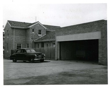
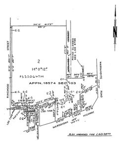
Police Stations (Ararat)
... Ararat is a city in south-west Victoria, Australia, about...Victoria Police Museum 313 Spencer Street Docklands ...Ararat is a city in south-west Victoria, Australia, about 198 kilometres west of Melbourne, on the Western Highway on the eastern slopes of the Ararat Hills and Cemetery Creek valley between Victoria's Western District and the Wimmera. It is named after Mount Ararat 10 kilometres south-west of the town. A police station opened in Ararat in 1859, though there was a police presence in the area formerly known as Cathcart, Canton Lead and later Mount Ararat. In 1861 staff consisted of 1 Superintendent, 2 Mounted Constables, 1 Sergeant 2nd class, 1 Senior Constable, 8 Constables. The police reserve was on land bounded by Ligar Street, Barkley Street, Ingor Street and High Street. In 1930 the police station was described as a six-room brick dwelling with a slate roof, situated on one quarter acre of land. There was also a bathroom, wash-house, pantry, office, muster room and quarters for a single constable, stables with three stalls, and a lock-up consisting of two six-person cells. Later residences were located at 3 Ligar Street (brick veneer with a tile roof); 32A High Street (brick veneer with tile roof); and 3 Tobin Street (wood with an iron roof). A new, purpose built police station was opened in October 2010 at 77 Barkly Street. The Ararat Police District was reformed into the Wimmera Police District in 1870. Ararat Police Station became part of "R" (Glenelg) District in January 1948 and "M" (Highlands/Wimmera) District from March 1990. A list of police stationed at Ararat from 1903 - 1930 is available from the Victoria Police Museum8 photos comprising: 7 black & white photos 1 colour photopolice stations; ararat police station -
 The Beechworth Burke Museum
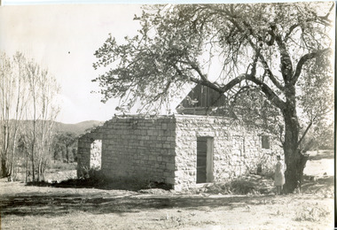
Photograph, Approximately 1930
Taken in approximately 1930, this photograph depicts the ruins of Rosehill Dairy. A woman stands beside the ruins, observing them solemnly. The owner of this once prominent dairy, John Brewer, was born in Cornwall, England in 1832. After coming to Australia in 1849, Brewer worked in various forms of livestock transportation. Upon hearing of the vast discovery of gold in Victoria's north-east, he engaged in mining in the Ovens Goldfield district before starting his own dairy on Wooragee road (now Old Wooragee road). The Wooragee Valley, approximately five kilometres north of Beechworth, was used extensively during the nineteenth century to build farming practices in the area, possessing eighteen farms by 1860. Brewer enjoyed a prosperous career in the dairy industry, personally delivering milk to the residents of Beechworth. He died on the thirteenth of August 1915, a few weeks shy of his eighty-third birthday. As this photograph is dated approximately fifteen years later, it can be assumed that the dairy fell into neglect following his death. This photograph is historically significant as it provides insight the development of the dairy industry in Beechworth in the second half of the nineteenth century.Black and white square photograph printed on matte photographic paper Reverse: 1997.2912 / John Brewers / Rosehill / Dairy / top of the 'rising sun' /john brewer, 1930 beechworth, rosehill dairy, dairy industry beechworh, dairy factories beechworth, dairying, dairy farm beechworth, wooragee road, wooragee valley, old wooragee road, dairy farm ruins -
 The Beechworth Burke Museum
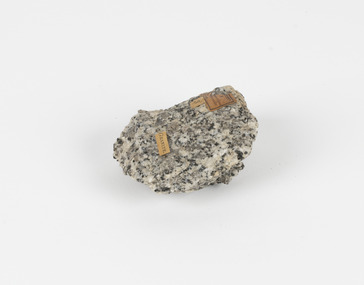
Geological specimen - Granodiorite, Unknown
This specimen was found in Harcourt, Victoria. Harcourt is a small historic gold rush town located in a valley at the foot of Mount Alexander (741 m) in the Central Highlands of Victoria. In recent times the goldrush origins of the town have been replaced by a district known for apples, cider and wine. The Traditional owners of Harcourt are The Dja Dja Wurrung people. Granodiorite is a coarse-grained intrusive igneous rock similar to granite, but containing more plagioclase feldspar than orthoclase feldspar. Granodiorite has greater than 20% quartz by volume, and between 65% and 90% of the feldspar is plagioclase. This piece is of significance due to its provenance in Harcourt, Vic. Granodiorite is commonly produced in volcanic arcs, and in mountain buildings where it emplaces as large batholiths in mountain roots. Granodiorite is the plutonic equivalent of dacite. This specimen is part of a larger collection of geological and mineral specimens collected from around Australia (and some parts of the world) and donated to the Burke Museum between 1868-1880. A large percentage of these specimens were collected in Victoria as part of the Geological Survey of Victoria that begun in 1852 (in response to the Gold Rush) to study and map the geology of Victoria. Collecting geological specimens was an important part of mapping and understanding the scientific makeup of the earth. Many of these specimens were sent to research and collecting organisations across Australia, including the Burke Museum, to educate and encourage further study.Granodiorite is a coarse-grained intrusive igneous rock similar to granite, but containing more plagioclase feldspar than orthoclase feldspar. According to the QAPF diagram, granodiorite has a greater than 20% quartz by volume, and between 65% and 90% of the feldspar is plagioclase.GRANDIORITE. / Locality: / Harcourt, Victoria / Other label: Geological survey / R S / Loc Harcourt quarries [?] Alexander / 1/4 Sheet. | 4 | Granite /granodiorite, granite, burke museum, harcourt, coarse-grained, igneous, plagioclase feldspar, orthoclase feldspar, quartz, mount alexander, the dja dja wurrung people, the traditional owners, central highlands of victoria, gold rush -
 The Beechworth Burke Museum
Photograph, Unknown c.1930s
This image shows Bethanga Bridge, which was constructed between 1927 and 1930 in Albury, NSW. The bridge was a necessity due to the building of the Hume Dam (Wier), 1919-1936. Bethanga Bridge is a long, nine-span, riveted-steel, variable depth, Pratt Truss road bridge of nine principal spans of 82 metres and a total length of 752 metres over the flooded valley of the Murray River, now part of Hume Reservoir. Because of its unique location, over the waters of a dam with the border running down the centre of the body of water, the Bethanga bridge is the only built structure shared by both New South Wales and Victoria. It was built 1.6 kilometres upstream of the dam and in 1961 was raised 300mm, with a concrete deck replacing the original wooden deck. The State Rivers and Water Supply Commission of Victoria and the New South Wales Department of Public Works were responsible for the construction works for the Hume Weir under the River Murray Waters Agreement. It is apparent that a similar joint arrangement was made for the construction of the Bethanga Bridge as part of the Hume Weir works.This photograph of the Bethanga Bridge is of historical significance as it showcases the architectural skills of Percy Allen and Vincent Packer. Additionally, it reveals the environmental landscape of the 1920s-1930s, is linked to the Hume Dam and both New South Wales and Victorian heritage. Unmounted black and white rectangular photograph. Reverse: 1997.3196 84-20-3bethanga, bethanga bridge, hume dam, pratt truss, murray river, hume weir, transportation -
 The Beechworth Burke Museum
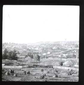
Photograph - Lantern Slide, c1900
Miners from Snake Valley lobbied the Victorian Government in 1855 to make land available for sale for farming purposes as an alternative occupation and income for people who wished to stay in the region but move away from gold mining. A secondary motivation was to increase the supply of fresh produce and decrease prices of items that otherwise needed to be transported from Melbourne or other regions. Forty-three country lots were initially offered in the Three Mile area, ranging in size from two to ninety acres and costing from £1 to £3 per acre. An additional eighty-five country lots were auctioned later in the year, in addition to many smaller suburban lots. More lots were offered than sold, initially, but this represented conditions of sale requiring the total purchase cost up front which many people interested in purchasing could not afford, especially as land purchased for farming would accrue substantial additional costs for clearing and labour before becoming productive. Further lobbying activities and the election of parliamentary members sympathetic to the cause took place through the 1850s. Ovens Parliamentary Member, Daniel Cameron, was re-elected in 1856 on a platform of surveying the land for public selection with deferred payment options. Land reform remained an issue in the area through the 1850s and early 1860s, impacting broader decisions in the new State of Victoria relating to voting rights, use of Crown land and the farming of land that wasn't always suitable for the purpose. This photograph depicts Beechworth in approximately 1900, after several waves of land sales resulted in increasingly levels of development. Lantern slides, sometimes called 'magic lantern' slides, are glass plates on which an image has been secured for the purpose of projection. Glass slides were etched or hand-painted for this purpose from the Eighteenth Century but the process became more popular and accessible to the public with the development of photographic-emulsion slides used with a 'Magic Lantern' device in the mid-Nineteenth Century. Photographic lantern slides comprise a double-negative emulsion layer (forming a positive image) between thin glass plates that are bound together. A number of processes existed to form and bind the emulsion layer to the base plate, including the albumen, wet plate collodion, gelatine dry plate and woodburytype techniques. Lantern slides and magic lantern technologies are seen as foundational precursors to the development of modern photography and film-making techniques.This glass slide is significant because it provides insight into Beechworth's built environment and infrastructure in the early Twentieth Century, around the time of Australia's Federation. It is also an example of an early photographic and film-making technology in use in regional Victoria in the time period.Thin translucent sheet of glass with a square-edged image printed on the front and framed in a black backing. It is held together by metal strips to secure the edges of the slide.burke museum, beechworth, lantern slide, slide, glass slide, plate, burke museum collection, photograph, monochrome, indigo shire, north-east victoria, farming, squatters, miners, agriculture, land-clearing, land reform, daniel cameron, land sales, three mile, snake valley, tarrawingee -
 Orbost & District Historical Society
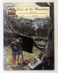
journal, E-Gee Printers, Voice of the mountains, 1993
"The Association was officially launched in November 1967 with the aim of preserving and maintaining good relations and understanding within the cattle industry and between that industry and all bodies and organisations with which the industry is associated in the spheres of Government, and land use and marketing." (ref Mountain Cattlemen's Association web-site) Since 1972, the Mountain Cattlemen’s Association of Victoria, have produced a journal, “The Voice of the Mountains”. This journal commemorates the activities and history of the previous twelve months and bygone years of cattlemen and their families. This item was used in the library of Orbost Secondary College. The journals form a part of Victoria’s history and are a useful research tool.A 64 pp book covered in clear contact. On the front cover is a coloured photograph of two boys reading an unveiled plaque for Wally Ryder at Pretty Valley. It is titled :"Voice of the Mountains, Journal of the Mountain District Cattlemen's Association of Victoria Inc, 1993 No 16" and is priced at $4.50.journal-voice-of-the-mountains cattle-industry cattlemen-history -
 The Beechworth Burke Museum
Photograph - Photograph - Reproduction
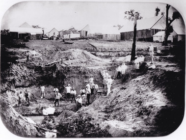
After gold was discovered to be deposited "for miles along Woolshed Valley" in the early 1850s, the Woolshed became a major site of mining activity in the north-east . This region was divided into large claims of 80 yards long, one of which was the one depicted in this photograph, called 'Big Johnson's Claim'. Claims such as this utilised a range of technology, including water wheels, steam engines, sluices and toms, most of which would not arrive until after 1856 when this photograph was taken. The Woolshed initially became prosperous in 1855, and labourers, such as the ones depicted in this photograph, engaged in sinking work for 7 pounds a week, whilst other mining labourers could earn up to nine. The search for gold is ingrained into the history of Victoria and therefore, images like this one which portray an open cut sluicing site can reveal important information for society and technology for the date when the photograph was taken. This image is of important historical significance for its ability to convey information about the operations of mining claims, particularly of the Woolshed Valley area that this photograph documents. This image is important for current research into the history of Woolshed, which was a major site of mining significance and operations. Therefore, this image has the capacity to be beneficial for research into society and the motivations of those living and working in this region during this period and therefore, has social significance. The Beechworth Burke Museum has additional images relating to gold sluicing and the Woolshed area which can be analysed and studied alongside images like this one. A black and white rectangular photograph printed on matte photographic paper.Reverse: 7791 / page 34. / 52% / Big Johnstone / Claim on Woolshed Goldfields / 1856 / Note canvas [illegible] building / Burke Museum /woolshed, mining, claims, mining claims, big johnson, gold -
 The Beechworth Burke Museum
Photograph - Photograph - Reproduction, c1920
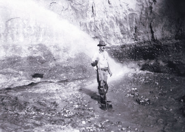
This photograph depicts mining operations (in particular, hydrolic sluicing) at Three Mile Mine, Barramutha, during the later periods of mining, 1920s-1950s. Three Mile Mine was a major site of mining activity sating back to the 1850s, although was often not as prosperous as other sites such as those situated on the Woolshed Valley. Many miners would leave Three Mile Mine for better prospects on other claims. The main, most successful 'rush' at Three Mile Mine occurred during and immediately following September 1855. This photograph, however, depicts a much later period.The search for gold is ingrained into the history of Victoria and therefore, images like this one which portray a miner at a sluicing site can reveal important information for society and technology for the date when the photograph was taken. This image, and its related images, it important for its historical significant of labour and mining extraction used for gold during the latter gold rushes in the 1900s. The Beechworth Burke Museum has additional images relating to gold mining in the region which can be analysed and studied alongside images like this one.A black and white rectangular photograph printed on matte photographic paperreverse: 7597.4 / copied from original on loan from Webb (Qld) / Donated Nov 2009 / Baarmutha Three Mile Mine 1920-1950 / Owned by Plain Bros then Parkinsons / John Weir or Jack Cox / Sluicing /mining, barramutha, three mile mine, sluicing, mine, beechworth -
 The Beechworth Burke Museum
Photograph - Carte de Visite, James Bray, 1870
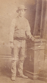
This photograph was taken in c.1870 and depicts Aaron Sherrtt who is best known for his involvements with, and eventual assassination by, the Kelly gang. He stands upright in the image with his arm leaning on a podium which reaches his hip. He is wearing an outfit for which he was infamous. Richard Warren, son of the proprietor of the Ovens and Murray Advertiser once stated that “anyone seeing [Aaron] coming down Ford Street would ask, “Who the hell’s this? Some advance agent for the circus?”’. The outfit Aaron wore for this particular photoshoot is reminiscent of this quote. He wears an unusual spotted shirt with a waistcoat and a sash is tied at his waist. He wears boots which turn up slightly at the toes. The hat is a “pork pie” hat which is worn in the typical “Greta Mob” style with the chinstrap under the nose. Aaron Sherritt was born in 1854 in Prahran, Melbourne, to Irish Protestant parents John and Anne. Sherritt stood at 5 foot 10. He had hazel eyes, dark brown hair and pale olive skin. Sherritt was childhood friends with Kelly Gang member, Joe Byrne, having previously attended the same school. Both men had a reputation for stealing horses and on one occasion, after stealing and butchering a cow, Sherritt and Byrne were convicted to six months in Beechworth Gaol (1876). Sherritt, along with Byrne, were reportedly recruited by Ned Kelly in 1877 in stealing stock; however, Sherritt never became a fully-fledged member of the Kelly Gang. Nevertheless, Sherritt scouted for the Kelly Gang in 1878. He later struck a deal with the police (specifically, with Chief Commissioner Standish) to save Joe Byrne's life in exchange for leading the police to the other members of the Gang. From then on, Aaron Sherritt lived the dangerous life of a double agent, providing police with what is assumed today to have been outdated or incorrect information in return for money. On the 26th of June 1880, Aaron Sherritt was murdered in the Woolshed Valley. He was approximately 23-25 years old at death. This event marked the start of the Kelly gang’s last days. Sherritt was murdered by Byrne in front of his wife, 15 year old and heavily pregnant Ellen “Belle” Sherritt and her mother Ellen Barry. Also in the Sherritt dwelling on this particular night were four policemen. The intention behind Sherritt’s murder was for the police to send word to Melbourne that the Kelly gang had murdered Sherritt and a police train would be sent to Glenrowan where the rest of the Kelly gang were waiting. This plan did not go as predicted and ultimately the Kelly gang fell at Glenrowan in 1880. This photograph was taken by James Bray who worked as a professional photographer in Camp Street Beechworth from 1870-1891. He was one of four men who photographed the Kelly Gang after the siege in Glenrowan in 1880. He is also renowned for his previous work photographing members of the Kelly gang. This photograph is part of the Burke Museum "Kelly album" which includes a significant collection of photographs and artefacts connected to Ned Kelly and the Kelly Gang. Ned Kelly and his gang have become ingrained in Australian popular culture and thus many museums, art galleries and private collections house material connected to the Kelly story which allows the events and people to be researched and interpreted. Artefacts and photographs pertaining to the Kelly gang are particularly valuable for Australian museums. This particular photograph is significant for its connection to Beechworth photographer James Bray who is responsible for many images depicting members of the Kelly Gang. The photograph is also of artistic significance as an example of a Carte de Viste dating to 1880 and it's connection to Aaron Sherritt.Sepia rectangular photograph printed on card. Obverse: J.E.Bray./ Photo/ Beechworth Reverse: Portrait & Landscape/ Photographer 5/ Aaron Sherritt J E Bray Signature Beechworth/ Victoria Beware (almost erased out) Negatives Kept. Copies 5I/.Each May/ Be Had By Forwarding Name And Address/ Accompanied With Remittance To/ The Amount Of Order/ Photographs Coloured In Water Colours 10237. kelly album, woolshed valley, 1870s, kelly gang, joe byrne, ned kelly, aaron sherritt, james bray, beechworth, burke museum -
 The Beechworth Burke Museum
Photograph, 1907-8
The photo from 1907-8 is a sepia print, depicting a small valley with building at base. There are flumes visible above areas of water, trees on hills and a few small cottages on the hillside. Cock's Pioneer Gold & Tin Sluicing Co NZ No 2 Site. The photo was taken of Matthews Gully looking west. Sluicing was undertaken in the area from 1900 to 1942 with some short breaks between these periods. The image depicts a location mined by Cocks Pioneer Gold and Tin Sluicing Company (as recorded on the annotation on the card mount) The Cocks Pioneer Gold and Tin Mines N.L was one of El Dorado's two largest open cut sluicing mines of the 20th Century. The other was named the Cocks El Dorado Gold Dredging Company. The Cocks Pioneer Mines operated from 1901 until 1941 and found a total of 117,378 ounces of Gold and 1,673 tones of tin concentrates over these years. The Cocks company was formed in 1898 and operated until 1941. Open cut sluicing involved the use of high-powered hoses which used the centrifugal sand pump system (known as hydraulic sluicing) which broke down the soil which was then processed for gold and other precious metals. From 1914 , four years after this image was captured, the company reformed to Cocks Pioneer Gold and Tin Mines NL (previously it was known as Cocks Pioneer Sluicing Co) and undertook large scale sluicing operations until 1929 and then 1934-1941. El Dorado is located on Reedy Creek and is surrounded by forested country to the north and east. It is 20 km east of Wangaratta in Victoria's regional north-east. John Cock was the son of a Cornish minor who arrived in El Dorado in 1858. Cock founded his gold and tin mining company which ran successfully for many years in the El Dorado region. It was an open cut sluicing company because of the abandonment of underground mining after this was deemed too dangerous. In 1935 Cock's El Dorado Company commissioned the floating dredge which is still visible in El Dorado today. The dredge was built by the Thompson engineering works, Castlemaine, and weighed over 2,000 tones and today has a place on the Victorian Registers of historic buildings. Interestingly, the name El Dorado does not derive from the gold in the region, but from the Barambogie pastoral run completed by William Baker in 1840-1841. Gold was discovered in El Dorado 1854 but the gold was too deep for individual prospectors to find, it required the use of heavy machinery.The search for gold is ingrained into the history of Victoria and therefore, images like this one which portray an open cut sluicing site can reveal important information for society and technology for the date when the photograph was taken. This image is of important historical significance for its ability to convey information about sluicing and the methods used to find gold in 1910. It also shows a location where sluicing was undertook which provides insight into the impact of sluicing on the environment at a time when it was done. This image is important for current research into the history of El Dorado, a small regional location near Wangaratta in Victoria's North East. Therefore, this image has the capacity to be beneficial for research into society and the motivations of those living and working in this region during this period and therefore, has social significance. The Beechworth Burke Museum has additional images relating to gold sluicing and El Dorado which can be analysed and studied alongside images like this one.Sepia coloured rectangle photograph printed on gloss photographic paper Reverse: 1997. 2613/ A02613/ No2 site/ Matthews Gully/ Cocks Pioneer G&T. ?? Co NZ/ No2 Site looking West/ 1907-8/ (7)sluicing, hydraulic sluicing, 1907, 1908, mining, cock's pioneer gold & tin sluicing co nz, nz, site no 2, matthews gully, west, valley, building, cottages, hillside, trees, water, gold and tin mine -
 Ringwood and District Historical Society
Newspaper, Scrapbook Clipping, Library Collection, Ringwood, Victoria
Newspaper Clipping from the ""Mail", 29 October 96, P 26. "Schools mourn".Cancer has claimed two of Maroondah's school principals in recent weeks. Yarra Valley Anglican School principal Margaret Peters died last Sunday. She was appointed principal of Yarra Valley in 1994. Meanwhile, the principal at Tinternvale Primary School, Gary Hooper died of cancer on October 11. He was 54. A new principal, Martin Winfield, had been appointed to replace Mr Hooper, who had retired due to ill health -
 Ringwood and District Historical Society
Document - Folder, Commercial and Retail Property Sales Information, Civic Place and Melbourne Street, Ringwood - 1998
45 photocopied pages including - Plan of Subdivision No.LP80718, Parish of Ringwood, Victoria, Crown Portion 12(Part) and part of a former government road Ref Vol 8668 Fol 745. - Vendors Statement, Planning Certificate and Heritage Council (Victoria) Certificate issued for 20 Melbourne Street, Ringwood. - Maroondah City Council Land Information Certificate for 149 149A and 149B Maroondah Highway; number 8 Civic Mall; and numbers 16, 20, 22 & 24 Melbourne Street Mall. - Yarra Valley Water statements relating to encumbrances for Shop 11, 149 Maroondah Highway; Shop 10, 149A Maroondah Highway; Shop 9, 149B Maroondah Highway; numer 8 Civic Place; Unit 3, 20 Melbourne Street; Office 4, 20 Melbourne Street; Shop 7, 22 Melbourne Street; and Shop 8, 24 Melbourne Street. - Land Tax Certificate pertaining to Commonwealth Bank, Civic Place, Ringwood. - Certificate of Title Vol 8892 Fol 906, Lot One on Plan of Subdivision No. 80718, Parish of Ringwood - Hanover Developments P/L - 29th June, 1971. -
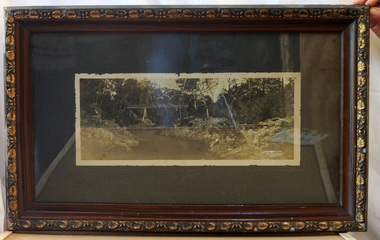 Orbost & District Historical Society
framed black and white photograph, C1920
Boggy Creek Bridge was built in 1916 as part of the Bairnsdale to Orbost extension to the main Gippsland Railway, and is situated in the middle of the township of Nowa Nowa, crossing a steep-sided and well-timbered creek-valley. This section of the line closed in 1987. This item is a pictorial record of the Boggy Creek railway bridge on the East Gippsland line. This bridge plays a major part in the identity and history of the town of Nowa Nowa, since Boggy Creek’s steep sided valley divides the township into two components.A black / white photograph of a bridge across a river in the bush. It is under glass in a brown wooden frame which has gold decorated edges. There appears to be a man sitting on rocks in the right front foreground.on front of photograph - "Nowa Nowa Creek, Gippsland, Victoria, Sears, Copyright"boggy-creek-nowa-nowa east-gippsland-railway bridge-rail -
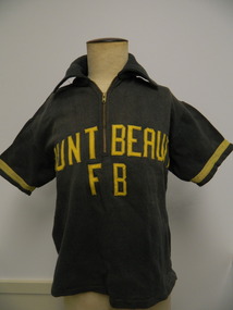 Kiewa Valley Historical Society
T-Shirt - Mt Beauty Fire Brigade x2
Mt Beauty rural fire brigade was established in 1948 by the State Electricity Commission of Victoria as an industry brigade. When Mt Beauty was handed over to the Shire in 1961, the fire brigade became a member of the Country Fire Authority (C.F.A.). Today it is an urban fire brigade. The t-shirt would have been used when members were together during fire drills, competitions, meetings etc. The black shirt was used prior to 1950 and the Red shirt was used after March 1950 The red t-shirt was used in the following yearThe t-shirt was part of the Mt Beauty fire brigade uniform indicating that the fire fighters were part of a team and were able and wanted to be recognised. It also indicates a strong and popular organisation. Black thick cotton t-shirt with collar and short sleeves. A zip is at the top front. Sleeves have yellow strip near their opening. "Mount Beauty F B" has been zig zagged stitched onto the front, also in yellow. Red thick cotton t-shirt with collar and short sleeves. 2 buttons at the top front. Sleeves have a yellow strip near their opening."Mount / Beauty" has been zig zagged stitched onto the front, also in yellow.Tag inside back under collar - "Sportswear / Simpson / of Melbourne / Mr - then P.A.B. handwritten in space provided. also '36' and 'All cotton' tags attached. Tag inside back under the collar - "Haworth Knit / Glen Iris, Melb./ 100% Cotton"mt beauty; fire brigade; clothing; state electricity commission of victoria -
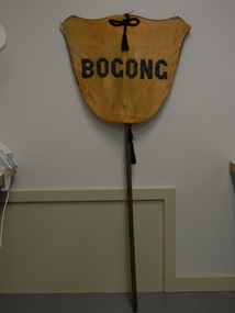 Kiewa Valley Historical Society
Banner - Bogong
Banners were used at schools on sports days to identify the school and/or the team. Bogong is a local town between Mt Beauty and Falls Creek and was established by the State Electricity Commission of Victoria during the construction of the Kiewa Hydro Electric Scheme. The school was opened on 28th Jan. 1941 and closed c1986. The banner probably belonged to the Bogong school and was used for sport carnivals and other events that included mixing with other schools.Wooden pole with yellow/orange satin shield cover on top. Black satin cord with tassels on top and bottom front and back. Black satin letters hand stitched on to form 'Bogong'. Fine black cord around outer edge also hand sewn.Bogongbanner; bogong state school; sport carnivals -
 Kiewa Valley Historical Society
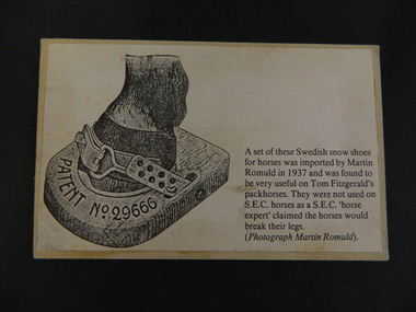
Card - Swedish Snow Shoes for Horses
Swedish snow shoes for horses were imported by Martin Romuld in 1937. They were used by Tom Fitzgerald's packhorses but not on the State Electricity Commission of Victoria's horses as a S.E.C.V. 'horse expert' claimed the horses would break their legs.Tom Fitzgerald lived on the Omeo Highway near Shannonvale and brought cattle up to the Bogong High Plains. He would have travelled in the snow during the year visiting his hut and maintaining his equipment. The S.E.C.V. worked on the Bogong High Plains all year round during the construction of the Kiewa Hydro Electric Scheme. Copy of a black and white photo glued onto cardboard showing a "Swedish snow shoe for horses" followed by further information re their uses on the Bogong High Plains. On the back stamped in blue 'Rescent'swedish snow shoes; horses; bogong high plains -
 Kiewa Valley Historical Society
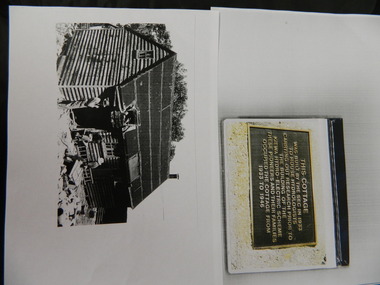
Wilkinson Lodge - copies of 6 photos, 1 plaque, 1 article
Wilkinson's Hut was built for the State Electricity Commission of Victoria in 1932 as a permanent residence for the snow research program manager, who was the resident engineer of the Kiewa Hydro Electric Scheme. The hut was sold in 1948 to the Ski Club of Victoria / Victorian Alpine Club and renamed Wilkinson Lodge. In 1958 it was sold to the Melbourne Bushwalkers Club. It was burnt down on 17th January 2004.Wilkinson Lodge was located at Wallace Gap on the Bogong High Plains and was the first S.E.C.V. permanent residence for the workers of the Kiewa Hydro Electric Scheme. It is also an early built lodge owned briefly 1946 - 1958 by the Ski Club of Victoria / Victorian Alpine Club and used by skiers before other lodges were built at Falls Creek. It was used by bushwalkers until it was burnt down thus in itself depicting part of the history of the area.5 pages of copies of photos of Wilkinson Lodge, 1 page of a copy of the destruction of Wilkinson Lodge (6 small photos), 1 page of a copy of a plaque titled 'This cottage' and 1 page of an article from the Border Mail (newspaper) dated 19th Jan. 2004.wilkinson hut; secv; ski club of victoria; melbourne bushwalkers club; fire -
 Kiewa Valley Historical Society
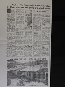
Newspaper Article Copy - Sale of Mt Beauty Town, 1960's
Mt Beauty township was sold in the 1960's after the State Electric Commission of Victoria had finished the construction of the Kiewa Hydro Electric Scheme. The sale of Mt Beauty township signified the end of construction of the Kiewa Hydro Electric Scheme and the beginning of Mt Beauty under the Bright Shire (now Alpine Shire). Many of the workers for the State Electricity Commission of Victoria remained in Mt Beauty and many returned to retire in the town in later years.An A3 sized Photocopy of the newspaper article regarding the sale of the Mt Beauty township with a photo of George Rosen and two houses and an A4 newspaper photocopy of the headline newspaper; mt beauty sale; secv; bright shire -
 Kiewa Valley Historical Society
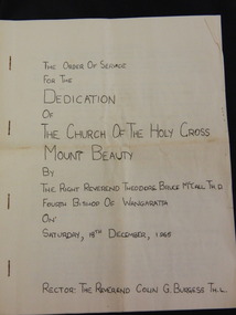
Booklet - The Church of the Holy Cross Mount Beauty, The Order of Service for the Dedication of the Church of the Holy Cross Mount Beauty, December 1965
The Anglican Church of the Holy Cross was situated in Maddison St., Mt Beauty. It was dedicated on Saturday 18th December 1965. The Rector was The Reverend Colin G. Burgess Th.L.Mt Beauty was created by the State Electricity Commission of Victoria during the construction of the Kiewa Hydro Electric Scheme. During the late 1960's the town was handed over to the Bright Shire and its building sold. A plaque was unveiled in the porch to commemorate the Dedication of the Church by Mr H. H .Williams, the chief engineer of the Kiewa Scheme.5 page hand made book with white pages and black typing stapled together with 4 staples. The book includes the Order of Service, The Procession to the Altar, The dedication of the Church, The dedication of the Furniture, At the Prayer Desk, At the Lectern At the Pulpit, At the Chancel Step, At the Altar, The Dedication Mass, The Collect, The Epistle, The Gospel, Proper Preface and is written by the Right Reverend Theodore Bruce McCall, Fourth Bishop Of Wangaratta on Saturday, 18th Dec., 1965mt beauty; anglican church; religion; -
 Kiewa Valley Historical Society
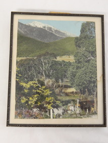
Photo Framed - Tawonga South, c1940's
Tawonga South was situated between the rural township of Tawonga and the State Electricity Commission of Victoria's construction town of Mt Beauty. The building in the fore ground of the photo was built before the Mt Beauty township was built as the occupier was working on the Kiewa Hydro Electric Scheme.The Barters came to work on the State Electricity Commission of Victoria's Kiewa Hydro Electric Scheme before housing in the town of Mt Beauty was built. The Barters rudimentary dwelling was probably not a legal building. The photo was taken by Vera Hore (nee Ryder), the publican at the Bogong Hotel near Tawonga South where the photo was taken. Vera, 1909 - 2000, was a keen amateur photographer.Colored photo of Tawonga South with a dwelling in the bottom of the right hand corner and Mt Bogong, covered in snow, at the top. Framed with cream card board 1 cm wide and a metal decorated frame surrounding it.On the back - "Vera Hore"tawonga south; vera hore; mt beauty -
 Kiewa Valley Historical Society
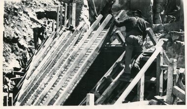
Photo - Junction Dam, September 1941
Junction Dam was part of the Hydro Electric Scheme during the 1940'sState Electricity Commission of Victoria construction of the Kiewa Hydro Electric SchemeBlack & white photo of Junction Dam constructionjunction dam, secv, bogong -
 Kiewa Valley Historical Society
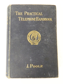
Book - Technical on Telephones / Switchboards, The Practical Telephone Handbook by J. Poole, 1912
This book includes "Guide to the Telephone Exchange". As the State Electricity Commission of Victoria had a telephone exchange on the Kiewa Hydro Electric Scheme at Mt Beauty, this book is of interest. The first telephone exchange was established in the U.S.A. in 1877. In 1912 most civilised countries had one. Improvements continued as outlined in the book explaining how they work.The State Electricity Commission of Victoria constructed the Kiewa Hydro Electric Scheme and communicated using a switchboard based in Mt Beauty. This book belonged Roy F. Leibig, the grandfather of a local electrician.Black hard cover book with gold embossing of title, author and emblem "The Specialists Series" on the front cover. 630 pages with some black and white diagramsInside: "W. Kerr Newmann / 89 Moreland Grove / Coburg" written in pencil "S. Dunkerton / 8 Horne St / E. Brunswick / Oct. 7th 1913" crossed out with pencil (over handwriting with pen) "R.F. Leibig / "Orama" / Stafford St / West Preston" written in inkinstructional book; technical; telephones; switchboards; telephone exchange; state electricity commission of victoria -
 Kiewa Valley Historical Society
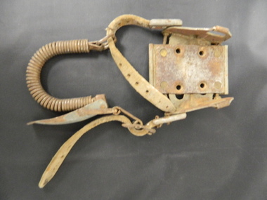
Ski Binding
Skiers used this binding to hold their foot onto the ski.The Bogong High Plains has been a skiing destination for Cross Country and Downhill skiers since the 1930's and especially during and after the State Electricity Commission of Victoria's construction of the Kiewa Hydro Electric Scheme. The steel plate indicates it is for the Bogong High Plains area.Dirty metal binding with a leather adjustable strap on each side and a flexible coil joining the two straps at the back. There are 4 holes on the steel plate allowing for attaching it to the ski.Inscribed on the metal plate at the front. "Bogong / toe iron / pat app for / Australia"ski binding; bogong high plains; cross country skiing -
 Kiewa Valley Historical Society
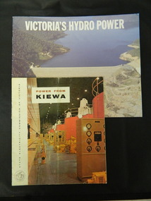
Booklets - Kiewa Hydro Electric Scheme, 1. "Power From Kiewa" and 2. "Victoria's Hydro Power", 1. Made in July 1968 and 2. Made in Aug. 1985
1. The State Electricity Commission of Victoria built the Kiewa Hydro Electric Scheme from the 1930's to the 1960's. This booklet was to inform visitors and to promote tourism. 2. The State Electricity Commission built several hydro power stations from 1928 - 1981. This booklet names each with a summary and explanation.The State Electricity Commission of Victoria built the Kiewa Hydro Electric Scheme establishing infrastructure such as the Bogong and Mt Beauty townships and the opportunity for tourism in the area.1. Colored soft cover with photo of McKay Creek Power Station on the front and Mt Beauty township on the back. Published by the SECV 2. Colored soft cover with Rocky Valley Dam on the front and inserted photo of a stream and snow on the back. Published by the SEC.state electricity commission of victoria; kiewa hydro electric scheme; victoria's hydro electric power; kiewa; mckay creek power station; clover power station; west kiewa power station -
 Kiewa Valley Historical Society
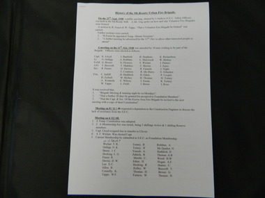
Papers - History of the Mt Beauty Fire Brigade
The Mt Beauty Fire Brigade commenced under the State Electricity Commission of Victoria in 1948. It was a (Country Fire Authority) C.F.A. Brigade from December 1961 and later an Urban Fire Brigade. The Fire Brigade and its Ladies Auxillary provided many community activities as well as protecting the population.The State Electricity Commission of Victoria established the Mt Beauty Fire Brigade during the construction of the Kiewa Hydro Electric Scheme. Its Ladies Auxillary was very active and involved, serving the community by raising money for the brigade and providing social occasions such as 'Deb' balls.One set of two pages and one set of eleven pages of the History of the Mt Beauty Fire Brigade and Mt Beauty Urban Fire Brigade respectively. Typed and photocopies.mt beauty fire brigade; ladies auxillary; deb balls -
 Kiewa Valley Historical Society
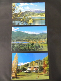
Postcards - Mt Beauty x3
Mt Beauty is an all year tourist destination. Mt Beauty Chalet no longer exists as it was burnt down. It was a landmark in the town especially during the State Electricity Commission of Victoria construction days.Mt Beauty is a construction town built in the 1940's and 1950's by the State Electricity Commission of Victoria during the construction of the Kiewa Hydro Electric Scheme.Three colored postcards created for tourism 1. Mt Beauty Chalet 2. Mt Beauty Township 3. Mt Beauty Township with Pondage and Mt Bogongmt beauty chalet; mt beauty township; postcards -
 Kiewa Valley Historical Society
Folder - History of Mt Beauty Township, 1980's
'The Kiewa Story' by Graham Napier requested submissions by residents of Mt Beauty for inclusion in his book. The submissions give a lot of detail and cover many subjects.An in-depth history as remembered by people who lived and worked on the Kiewa Hydro Electric Scheme from the 1940's onwards. Many lived locally in the construction towns of Mt Beauty and Bogong.A collection of papers in a white folder with submissions by locals as requested for the book "The Kiewa Story" by Graham Napier, Geoff Easdown in 1986. There is an Index and also included a note that' submissions tell the story of the community involvement in Mt Beauty's development.kiewa story; graham napier; mt beauty; kiewa hydro electric scheme; state electricity commission of victoria; communities -
 Kiewa Valley Historical Society
Folder - Bogong High Plains and Falls Creek, 1960's and 1970's
Tourism on the Bogong High Plains developed after/during the State Electricity Commission of Victoria construction of the Kiewa Hydro Electric Scheme.With the completion of the power stations on the Bogong High plains, tourism has created a new focus and different infrastructure/lifestyle for the community.A blue folder with a collection of papers & booklets on: 1. Discovery of Bogong High Plains 1962 2. SECV Discovery of Bogong High Plains 1968 3. SECV Kiewa Hydro Electric Scheme 1911 - 1961 4. Newspaper cutting - Mt Beauty 1974 5. McKay Creek Power Station and Clover Power Station 6. Falls Creek and Mt Beauty Tourist Map & brochures 7. Bogong High Plains Tour 1973bogong high plains; falls creek; tourism; -
 Kiewa Valley Historical Society
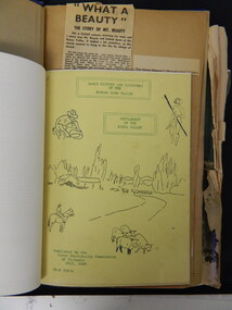
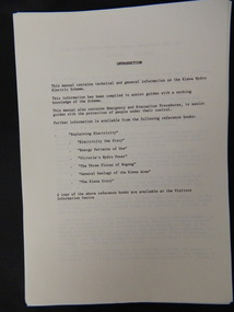
Folder - The Kiewa Hydro Electric Scheme
Kiewa Hydro Electric Scheme covering the years 1911 -1961 was constructed by the State Electricity Commission of Victoria.Technical and general information on the Kiewa Hydro Electric Scheme 1911 - 1961In a clear plastic envelope shaped folder are photocopied papers covering the Kiewa Hydro Electric Scheme. The Index includes twelve headings.kiewa hydro electric scheme; state electricity commission of victoria; -
 Kiewa Valley Historical Society
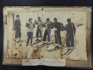
Photo - Skiers 1946, August 1946
During winter skiers skied on the Bogong High Plains. During the 1940's the State Electricity Commission of Victoria was constructing the Kiewa Hydro Electric Scheme and skiing was part of their employees recreation. Skippy St Elmo won ski races during the 1940's practising on the High Plains where she and her husband lived. Her husband worked for the S.E.C.V..Employees of the State Electricity Commission of Victoria were early skiers on the Bogong High Plains. The area is a well known tourist centre for skiers, bush walkers and bike riders.Black and cream photo glued onto thick cardboard with a label glued on at the bottom.L to R Wally Baldwin, Joyce Fisher, Dick Moore, / Chas Armada, Skippy St Elmo, Toni St Elmo / August 1946snow skiers; bogong high plains; state electricity commission of victoria; kiewa hydro electric scheme; skippy st elmo