Showing 2842 items
matching wests road
-
 Surrey Hills Historical Society Collection
Photograph - Aerial view Riversdale Heights Estate area, c1923
... of the area near the corner of Warragul and Riversdale Roads looking... and Riversdale Roads looking west towards the city. Some features have ...This was probably part of a real estate promotion for the sale of the Riversdale Heights Estate. This was subdivided by Messrs. Duncan and Weller. Of the allotments offered, 30 were sold and realised £4600. Date of this sale was c December 1923. This suggests that the date This are was one of the last pieces of former rural land to be sub-divided for housing in Surrey Hills.The land between it and South Surrey Park was sub-divided post WW1, hence the naming of the streets after sites of WW1 battles.A black and white reproduction of an aerial photo of the area near the corner of Warragul and Riversdale Roads looking west towards the city. Some features have been identified by name including the Riversdale Heights Estate, which was being sub-divided. North and South Courts are shown. Other roads (unmarked) in the foreground are Graham Street, Allie Street, Thistle Street, Lille Street, Amiens Street, and Marne Street. Beyond these is the area marked 'PARK' (South Surrey Park), which is devoid of vegetation. Areas of Camberwell and Canterbury are also shown. The area covered extends to beyond St Dominic's Church. The original is mounted on a cream deckle-edged paper.Beneath the original on the mount: "SOUTH SURREY HILLS LOOKING WEST c. 1936" [The reference to the sale in the Box Hill Reporter of December 1923 found on Trove suggests that this date is not accurate.] Rear top LH corner of original in Jocelyn Hall's handwriting: "For Centre / from Mr James Long"riversdale heights estate, riversdale road, allie street, south surrey park, lille street, thistle street, amiens street, marne street, south court, north court, duncan and weller, real estate sales, graham street, st dominics church, highfield park, canterbury primary school, aerial photo -
 Victoria Police Museum
Police Stations (Armadale)
... was incorporated into Malvern Sub-district and west of Orrong Road... was incorporated into Malvern Sub-district and west of Orrong Road ...Armadale is an inner suburb of Melbourne, Victoria, Australia, 7 km south-east of Melbourne's Central Business District, located within the City of Stonnington local government area. Armadale Police Station opened, in Melbourne Police District, on 11 May 1885. Its original location is unknown, but in 1890 it is listed in the Sands & McDougall directory as at 295 Hight Street. From 1985-1920 it was located at 20/22 Auburn Grove, 1925-1930 at 769 High Street and 1935-1946 at 3 Cheel Street. The station closed on 28 January 1946. The sub-division east of Orrong Rd was incorporated into Malvern Sub-district and west of Orrong Road into Prahran Sub-district. In a special 1930 issue of the Victoria Police Gazette the Armadale Police Station was described as a seven-roomed brick dwelling with a tiled roof on land measuring 127' x 104' x 98'. There was also a bathroom and W.C., a wash-house, office, and a lock-up (one cell). This is probably a description of the Cheel Street police station. It was staffed by one senior constable and three foot constables.12 photographs comprising 8 coloured images and 4 black and white images 1 sketch plan of Old Armadale Police Stationpolice stations; armadale police station -
 Melbourne Tram Museum
Postcard, Rose Stereograph Co, "Princes Bridge and St Kilda Road Melbourne", late 1930s
... is the Shrine of Remembrance. To the west of St. Kilda Road running... tram in the view at the intersection of City Road to the west ...Rose Series postcard No. P 10649, titled "Princes Bridge and St Kilda Road Melbourne", looking south from Flinders St station clock tower showing Princess Bridge and St. Kilda Road with a W2 class tram in the view at the intersection of City Road to the west and Alexandra Avenue to the east. In the background is the Shrine of Remembrance. To the west of St. Kilda Road running in parallel from City Road to Mafra Street is Sloss Street, it was removed in the late 1960' for the construction of the National Arts Center. The former "Green Mill" dance hall built in 1926 become the "Forty Club" in 1933 and evolved to being the "Trocadero Palais" by the late 1930's can be seen on the right of the photo. The road on the south side of the Yarra River, at the bottom of the photo, is Riverside Avenue. Yields information about St Kilda Road, late 1930s.Postcard - printed real photograph with Rose Stereograph Co. name on the rear.trams, shrine of remembrance, st kilda road, princes bridge, w2 class, tramways -
 Stawell Historical Society Inc
Photograph, Great Western 1866
... of road, looking west. ... of road, looking west. Stawell Great Western 1866 Photograph ...Great Western. Part of a collection of Photographs by Mr. O.G. Armstrong as commissioned by the Shire of Stawell for the Inter-colonial and Paris Exhibition in Melbourne in 1866. Great Western began as a changing station on Concongella, northeast of the present Township. The gold rush in Great Western began in 1858 and soon after a post office and store opened. A Township was surveyed and lots sold in October 1858. The gold soon passed and the diggers went on, leaving a small settlement. In 1863 Jean Pierre Trouette and Emile Bampied, his brother-in-law, planted the first vines and build the first winery, thus setting a firm foundation upon which the present wine industry has been built. Telegraph poles and wires visible. Bakery visible in distance on right of road, looking west. stawell -
 Wodonga & District Historical Society Inc
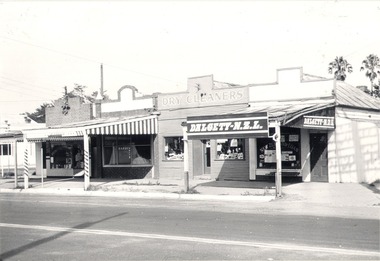
Photograph - Mann Collection Album - DALGETY N.Z.L, High Street West - corner of Melbourne Road to Railway, C. 1960s
... Mann Collection Album - DALGETY N.Z.L, High Street West...Mann Collection Album - DALGETY N.Z.L, High Street West...Dalgety-N.Z.L in High Street West - corner of Melbourne... N.Z.L, High Street West - corner of Melbourne Road to Railway ...Elaine Mann was married to David Mann, a successful Wodonga businessman and community leader who passed away in Wodonga in June 2012. David was a member of the Mann family who began their business in Wodonga in 1920. Elaine was a teacher in Wodonga for many years and an active member of the community.This photo collection is of significance as it documents how the businesses and buildings in Wodonga have evolved and contributed to community throughout the late 20th century.Dalgety-N.Z.L in High Street West - corner of Melbourne Road to the railway line. Businesses include a barber, dry cleaners and Dalgety-N.Z.L. Dalgety and Company Limited merged in November 1961 with New Zealand Loan and Mercantile Agency Company Limited, one of its principal competitors in Australia's eastern states and New Zealand. As of 30 June 1970, the business name Dalgety New Zealand Loan was delisted, with the company becoming Dalgety Limited. This information dates the photo as being taken between 1961 and June 1970. This site later became Wodonga Home Furnishers. The building was demolished in November 1998 to make way for the realignment of Elgin Street to join what was then Jack Hore Place. wodonga businesses, high st wodonga, railway crossing, dalgety -
 Orbost & District Historical Society
black and white photograph, first half 20th century
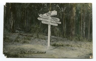
... Prior to the sealing of the Princes Highway west of Orbost... gippsland Prior to the sealing of the Princes Highway west of Orbost ...Prior to the sealing of the Princes Highway west of Orbost, the road surface was anything but good, even by C1917 when cars started to use the road. From Orbost the old road via Marlo to Sydenham was abandoned for the new location which traversed more rugged country via Cabbage Tree, Bell Bird and Club Terrace to Cann River, and the reason for this diversion was on account of settlements being established at Murrungowar and Club Terrace, at which latter place there was a temporary rush to obtain gold. This road was constructed by the Public Works department and a maximum grade of 1 in 19 was adopted, and as speed was not to be catered for the grade followed in and out round the spurs and gullies, resulting in a maze of turns and twists which required a good deal of skill on the part of the horse driver to negotiate." - Bairnsdale Advertiser, Friday, May 2, 1947. (More information from Newsletter February 2010)This is a pictorial record of an early road distance sign on a major highway through East Gippsland. The distances are indicated in miles, a measurement standard no longer in use.A black / white photograph postcard of the signpost at the Victorian - New South Wales border. It shows distances to Sydney and Eden on one arrow and distances to Melbourne and Genoa on another. on front - Vic - NSW Borderprinces-highway-east-gippsland road-transport road-sign -
 Orbost & District Historical Society
black and white photograph, late 19th century - early 20th century
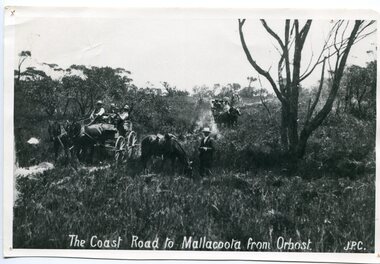
... Prior to the sealing of the Princes Highway west of Orbost... gippsland Prior to the sealing of the Princes Highway west of Orbost ...Prior to the sealing of the Princes Highway west of Orbost, the road surface was anything but good, even by C1917 when cars started to use the road. From Orbost the old road via Marlo to Sydenham was abandoned for the new location which traversed more rugged country via Cabbage Tree, Bell Bird and Club Terrace to Cann River, and the reason for this diversion was on account of settlements being established at Murrungowar and Club Terrace, at which latter place there was a temporary rush to obtain gold. This road was constructed by the Public Works department and a maximum grade of 1 in 19 was adopted, and as speed was not to be catered for the grade followed in and out round the spurs and gullies, resulting in a maze of turns and twists which required a good deal of skill on the part of the horse driver to negotiate." - Bairnsdale Advertiser, Friday, May 2, 1947. (More information from Newsletter February 2010)n the late 1800's early 1900's transporting goods by road was difficult and at times impossible because roads as thoroughfares did not exist.The means of travelling along the roads in the 1800's was by bullock wagon, horse pulled dray, pack horse or simply by foot. This road is still in use in East Gippsland as a part of many four-wheel-drive touring routes.A large black / white photograph of two horse - drawn wagons on a narrow sandy bush track. It is surrounded by scrub. There is one man standing beside a horse not harnessed to a wagon.on front - "The Coast Road to Mallacoota from Orbost JPC" -
 Wodonga & District Historical Society Inc
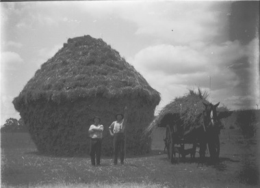
Negative - Haeusler Glass Negatives Collection - Two men in front of a haystack, Parker's Farm, Wodonga West
... the location of the Wodonga Golf Club in Parkers Road, West Wodonga.... the location of the Wodonga Golf Club in Parkers Road, West Wodonga ...The Wodonga Historical Society Haeusler Collection provides invaluable insight into life in late nineteenth and early twentieth century north east Victoria. The collection comprises manuscripts, personal artefacts used by the Haeusler family on their farm in Wodonga, and a set of glass negatives which offer a unique visual snapshot of the domestic and social lives of the Haeusler family and local Wodonga community. This digital image was produced from one of the glass negatives that form part of the collection, probably taken by Louis Haeusler (b.1887) with the photographic equipment in the Wodonga Historical Society Haeusler Collection. Parker Family - Samuel Skelton Parker, Jack Parker’s father, migrated to Australia from Ballymena, Country Antrim, Ireland in 1884. He married Bridget Cusack from County Clare in 1883. They had children William, James, Jack, Samuel and Rachel. After working on a station in northern NSW, they moved to Barnawartha and set up a butchery and later a bakery. In 1890 the family moved to Wodonga, buying a property in West Wodonga, which he called “Park Hall” after his home in Ireland. The property is now the location of the Wodonga Golf Club in Parkers Road, West Wodonga.This item is unique and has well documented provenance and a known owner. It forms part of a significant and representative historical collection which reflects the local history of Wodonga. It contributes to our understanding of domestic and family life in early twentieth century Wodonga, as well as providing interpretative capacity for themes including local history and social history.Digital image created from the Haeusler Glass negative collection. Two men in front of a haystack, working on the Parker family farm in Wodonga West. C. 1910wodonga pioneers, haeusler family, glass negatives, dry plate photography, parkers wodonga -
 Ringwood and District Historical Society
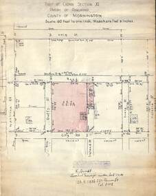
Document, 1926 Land Survey drawing of the area surrounding 1-5 City Road, Ringwood
... Road in the west and Victoria Road in the east. The Good... Road in the south, Wantirna Road in the west and Victoria Road ...Drawing on parchmentHand-drawn survey of what is now 1-5 City Road, Ringwood. Drawn by K Arndt, licensed surveyor, 237 Queen Street, Melbourne Tel 5118 on 25 September 1926. The block of land in question was 2 roods, 21 and 8/10 perches in size. The location was between Haig Street in the north, City Road in the south, Wantirna Road in the west and Victoria Road in the east. The Good Shepherd Retirement Village (Lutheran) now occupies the land. The drawing shows a number of existing weatherboard houses, fences and frontage sizes. A number of named roads were defined but no longer exist, these were Duffy Street (to the west), Evans Street (east) and Victoria Street (further east). Ireland Street still exists in the south. -
 Orbost & District Historical Society
black and white photograph, 1918
... to the sealing of the Princes Highway west of Orbost, the road surface... to the sealing of the Princes Highway west of Orbost, the road surface ...Tonghi Creek is 66km north - west of Orbost. Prior to the sealing of the Princes Highway west of Orbost, the road surface was anything but good, even by C1917 when cars started to use the road. From Orbost the old road via Marlo to Sydenham was abandoned for the new location which traversed more rugged country via Cabbage Tree, Bell Bird and Club Terrace to Cann River, and the reason for this diversion was on account of settlements being established at Murrungowar and Club Terrace, at which latter place there was a temporary rush to obtain gold. This road was constructed by the Public Works department and a maximum grade of 1 in 19 was adopted, and as speed was not to be catered for the grade followed in and out round the spurs and gullies, resulting in a maze of turns and twists which required a good deal of skill on the part of the horse driver to negotiate." - Bairnsdale Advertiser, Friday, May 2, 1947. (More information from Newsletter February 2010)This item is a pictorial record of roads in the early 20th century in East Gippsland.A large black / white photograph of a bridge over a small creek, surrounded by bush. The photograph is mounted on a thick cream coloured card.on back - "Bridge at Tonghi Creek 1918"tonghi-creek-bridge country-roads-east-gippsland -
 Melton City Libraries
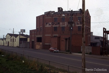
Photograph, Schutt and Barrie Flour Mills, 1969
... a chaff mill at the corner of Williamstown and Geelong Roads... a chaff mill at the corner of Williamstown and Geelong Roads ...Arthur Henry Schutt. Born 18th July 1912 at Spotswood He was the third child of John Ralph and Mary Jane Schutt. His grandfather was the first librarian of the Victorian Law Courts and his uncle, William Schutt, was a lawyer who later became the Chief Justice Sir William Schutt. His mother was born a Clutha House, stony Creek Yarraville, a was one of ten children. John Schutt opened a chaff mill at the corner of Williamstown and Geelong Roads at West Footscray. The mill was placed on in an old quarry below the ground which saved much of the backbreaking labour of heaving sheaves of hay up into the machinery, the below ground location enable the hay to be fed directly into the railway trucks into the cutters. An elevator then carried the chaff up from the ground directly into the waiting transport, at a great saving in manpower. The chaff mill became on of the largest in Victoria employing more than forty men, and later moved into flour milling.Schutt and Barrie Flour Mills, Melton South site. Opposite this Mill was a Public Weighbridge. A rail siding crossed Brooklyn road to serve chaff mill. The rail line crossed west of the Methodist Churchlocal identities, agriculture -
 Eltham District Historical Society Inc
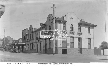
Photograph, The Rose Stereograph Company, Greensborough Hotel, Greensborough, c.1938
... View looking west across Main Road towards... melbourne View looking west across Main Road towards ...View looking west across Main Road towards the Greensborough Hotel built 1925 and adjoining shops. A Ford Model Y 4dr Saloon Registration 83-961 is parked in Main Road outside the shops. Visible are Ryan Bros Butchers, State Electricity Commission of Victoria, Dispensing Chemist, Ray Trinham Grocer & Ironmonger Ryan Bros Butchers sold their shop to new owners in December 1938. This glass plate negative was used to manufacture postcards (1:1 printing) for commercial sale by the Rose Sterograph Company and its subsidiaries. George Rose founded the Rose Stereograph Company in 1880 and was joined by Herbert (Bert) Cutts in the early 20th Century. The pair formed a lifetime working partnership and strong personal friendship. Assisted by George’s two sons, Herbert George and Walter, and later by Neil Cutts, the Rose Stereograph Company continued its operations for more than 140 years. The company was initially built on stereographs, but as cinema took over and stereographs fell out of fashion, the Rose Stereograph Company developed Australia’s first commercially viable photographic postcard business. Specialising in postcards of iconic historical moments and significant landmarks, The Rose Stereograph Company became a staple of the Australian travel industry.This remarkable collection of glass plate negatives, transparencies, and postcards – arguably Australia’s most significant photography collection outside of public hands – has been passed down through the generations, surviving war, relocation, and the harsh Victorian climate. The historic Rose Stereograph collection is the culmination of George Rose’s dream of capturing and preserving precious moments in time and remains the legacy of the Rose and Cutts families. It is with great sadness that the Cutts family says goodbye to a collection that spans five generations and 140 years. The Cutts family understands that for these historically important pieces to rest with one family is to deny others the pleasure of their custodianship.Glass Plate Negative Size: 9 x 13.9 cmGreensborough Hotel, Greensborough, Published by W. M. Butterworth No. 5postcard, travel, rose stereograph company, glass plate negative, greensborough, main road, w. m. butterworth, greensborough hotel, ford model y 4 dr saloon, dispensing chemist, grocer and ironmonger, ray trinham, ryan bros butchers, state electricity commission of victoria, peter and elizabeth pidgeon collection -
 Sunshine and District Historical Society Incorporated
Photograph - Three Old Sunshine Factories, Pratt, Charles Daniel, (1892 - 1968), Photographed circa late 1920's to early 1930's
... on the west side of McIntyre Road and Spalding on the east. Phoenix... on the west side of McIntyre Road and Spalding on the east. Phoenix ...These three factories clustered together and close to Albion Station provided manufacturing type of employment for several decades. All the factories have now disappeared and have been replaced by retail or service businesses. Spalding has been replaced by a Bunnings Hardware store, while the main retail outlet on the Nettlefolds site is Harvey Norman. Ironically part of the Phoenix Fireworks site is now occupied by the Metropolitan Fire Brigade, as well as other small businesses including a smash repair business, and a tyre retailer.The photograph provides a historical record of some of the types of manufacturing industries that existed in Sunshine, before retail or service industries began to replace them. Many of the younger generation do not know that fireworks, screws, or some sports items were manufactured in Sunshine not so long ago, and where the factories existed.The image depicted in this photographic copy is believed to be from circa late 1920's to early 1930's, and shows the NETTLEFOLDS, SPALDING, and the PHOENIX FIREWORKS factories. These factories were located in North Sunshine on the north side of Ballarat Road near Albion Station. Nettlefolds and Spalding are on the corner of Ballarat Road and McIntyre Road, with Nettlefolds being on the west side of McIntyre Road and Spalding on the east. Phoenix Fireworks factory is composed of small huts, and is situated on the north side of Phoenix Street at the rear of the Spalding factory. The photograph also shows a row of residential houses on Garnet Street which is on the east side of the Phoenix factory. Ballarat Road is still an undivided road and on the south side is a plantation of trees that once stretched from near Albion Station to Anderson Road. Other roads visible are Suffolk Road and Westmoreland Road.Nettlefolds Screw Worksnettlefolds, spalding, phoenix fireworks, screw works, ballarat road, mcintyre road, phoenix street, garnet street, westmoreland road, suffolk road. -
 Bendigo Historical Society Inc.
Document - Hustlers, Sheepshead and Deborah lines of reef
... yards west of Holmes Road, near Comet Creek, steel poppet legs... 2,588 feet, 60 yards west of Eaglehawk Road, California Gully ...Albert Richardson was a mining historian who wrote widely on the mines of the Bendigo Goldfield. The park opposite the Goldmines Hotel in Marong Road, is named in his honour. Five page document, hand written by Albert Richardson on lined foolscap and edited with cross-outs and insertions, . The mines along the Hustlers line of reef and the Sheepshead line of reef are described. Mines listed on Hustlers line of reef: Fortuna Hustlers (1888 - 1913), shaft 2,240 feet at rear of Buckell and Jeffrey's offices; Royal Hustlers Reserve No. 2 - two shafts 'City" 860 feet, now covered by R.S.L. building Pall Mall, steel poppet legs 60 ft high and 'Park Shaft" at rear of Camp Hill School, 1,775 feet, steel poppet legs 60 feet high; Hustlers Hill Group first worked by Jonathan Harris in 1853 and bounded by Valentine, Anderson and Ironbark Creek to the north and Milroy Street to the east, one of first areas worked for quartz reefing. It with Garden Gully line west and Victoria Hill Ironbark, formed by far the richest cross section of the Bendigo Goldfield. Great Extended Hustlers (1865-1921) close to intersection of Anderson Street and Hustlers Road, mullock heap against road and shored up around shaft, steel poppet legs now at Wattle Gully mine, Chewton, large winding machine, air compressor south of shaft and 36 head crushing battery. Hustlers Reef (Old Hustlers) and Hustlers Reef No. 1, two shafts, main 2,210 feet, about 220 yards east of Moran Street and against Fenton Street. , No. 1 shaft 1,140 feet and about 155 yards east of Moran Street. Lansell's Comet, Lightining Hill line, 2.100 feet, on Comet Hill approx 70 yards west of Holmes Road, near Comet Creek, steel poppet legs. United Hustlers and Redan (1876-1918), main Redan, 1,830 feet about 155 yards west of Sandhurst Roead, in line with Comet Hill State School, this hill known as Redan Hill. North, or New Hustlers, once known as Agnew Hustlers, wooden poppet legs, south side, Kneebone Street, Eaglehawk. Derby line, Johnson's No. 3, South Johnson's (east shaft of Collman and Tacchi) 439 feet on west wide of Woods Street, south of Wetherall Street. Paddy's Gully Line, south to north, some shafts - Lansell's 'Sandhurst" ('Needle") Eaglehawk Road shaft 2,425 feet, about 50 yards east of Needle Loops, a brick square sided chimney with Cleopatra Needle top. British American, 789 feet, just south of Holdsworth Road. Collman and Tacchi, main shaft 2,588 feet, 60 yards west of Eaglehawk Road, California Gully. Deborah Line of Reef, The Deborah (1932-1954) shaft 2.017 feet, west of Adams Road and south of Abel Street, Quarry Hill. North Deborah (1937 - 1954) shaft 1,151 feet, Breen Street, Quarry Hill, steel poppet legs. Central Deborah (1939-1954) shaft 1,347 feet Sheepshead line of reef, Lansell's South Red, White and Blue, shaft 2,124 feet, north east of Bellevue Road and 220 yards east of Adams Road. The New Red, White and Blue Consolidated (Big Blue) main shaft 2,416 feet. Lansell's Bendigo Battery 105 head, north of 'Big Blue" on his freehold lease, commenced crushing on 24th February 1895. After closing was erected as the Showground's Industrial Hall, July 1926. North Red, White and Blue, burnt down February 1926, new company 1934, closed 1938. Document is part of the Albert Richardson Collection of Bendigo mining history. bendigo, gold mining, deborah line of reef, sheepshead line of reef, hustlers line of reef, royal hustlers reserve mine, hustlers hill group of mines, great extended hustlers, hustlers reef no. 1, lightning hill line, old comet, collman and tacchi, lansell's comet, north deborah, central deborah, dhrrpdhrsf linr og trrg, new red, white and blue consolidated mine, big blue, lansell's bendigo battery, north red, white and blue mine, albert richardson collection -
 Yarrawonga and Mulwala Pioneer Museum
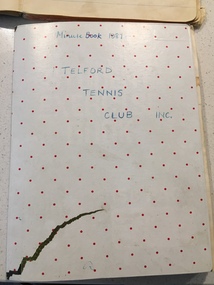
Telford Tennis Club minute books and records, 1920's to 2019
... Yarrawonga Road, west of the railway line, Telford station and silos... Yarrawonga Road, west of the railway line, Telford station and silos ...Telford Tennis courts were situated on the Telford Yarrawonga Road, west of the railway line, Telford station and silos. A thriving club existed from early 1920's with players from surrounding areas in early times. balls and tournaments were held as fundraisers. Prominent family names included Stevenson, Chappell, Mulquiney, Thom, Inchbold, Connell. Quinn. There were three teams during the 1960's playing in the Wilby and District Tennis Association ( WDTA) competition. Opponents included Wilby, Almonds, St Mary's, Bundalong, Savernake, Rennie, Roseneath, Burramine. Being in a low lying area the Telford dirt courts were often flooded. At the beginning of the season working bees were held to remove the weeds. mow the surrounds and line the courts During the early 1980's the courts were abandoned and home matches were played at the Yarrawonga Lawn Tennis courts. The club still has a team in the WDTA in 2019. A number of B grade Premierships have been won over the years however A grade premierships have been non existent. The club has always encouraged juniors to play and now the players mostly originate from Yarrawonga. Current President (2019) is Richard Inchbold, Secretary/Treasurer Joan Thom. The Bank account is held at the CMCU. The club is no longer IncorporatedCountry tennis teams provided a social outlet from the farming pursuits of the districtall enclosed in a cardboard box. Minute books 1927 to 2014 (not all complete). Includes photos, paper cuttings, Wilby and District Tennis Association draws, subs books, list of names of those who have played for Telford. Consumer Affairs returns, Incorporation papers, receipt books, some correspondence (later years)see photos -
 Eltham District Historical Society Inc
Negative - Photograph, Rose Stereograph Company, View at Eltham, Vic, c.1920
... . Henry Street road reserve on west side of Main road.... Henry Street road reserve on west side of Main road ...View at Eltham, Vic. Looking from Main Road near Henry Street towards Montmorency showing the railway trestle bridge. Henry Street road reserve on west side of Main road in foreground. c.1920 Copy of Rose Series Postcard P. 4348. (The Rose Stereograph Company) George Rose founded the Rose Stereograph Company in 1880 and was joined by Herbert (Bert) Cutts in the early 20th Century. The pair formed a lifetime working partnership and strong personal friendship. Assisted by George’s two sons, Herbert George and Walter, and later by Neil Cutts, the Rose Stereograph Company continued its operations for more than 140 years. The company was initially built on stereographs, but as cinema took over and stereographs fell out of fashion, the Rose Stereograph Company developed Australia’s first commercially viable photographic postcard business. Specialising in postcards of iconic historical moments and significant landmarks, The Rose Stereograph Company became a staple of the Australian travel industry. This photo forms part of a collection of photographs gathered by the Shire of Eltham for their centenary project book,"Pioneers and Painters: 100 years of the Shire of Eltham" by Alan Marshall (1971). The collection of over 500 images is held in partnership between Eltham District Historical Society and Yarra Plenty Regional Library (Eltham Library) and is now formally known as 'The Shire of Eltham Pioneers Photograph Collection.' It is significant in being the first community sourced collection representing the places and people of the Shire's first one hundred years.Digital image 4 x 5 inch B&W Negbridge street, eltham, eltham railway trestle bridge, postcard, rose stereograph company, shire of eltham pioneers photograph collection, trestle bridge -
 Melbourne Tram Museum
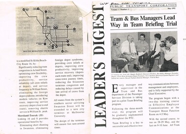
Document - Photocopy, Public Transport Corporation (PTC), "Leader's Digest", May. 1992
... , Moonee Ponds - West Maribyrnong, Kew Cotham Road - William St..., Moonee Ponds - West Maribyrnong, Kew Cotham Road - William St ...Photocopy of a newsletter to Public Transport Corporation staff, May 1992, titled "Leader's Digest", Vol 1 and No. 1 (unknown if any more published), with a photo of a group of five people undergoing a team briefing. Original document 16 pages, but only a few copied, principally about the proposed Tram Cross - Linking and Route Restructure proposals. Follows the Tram and Bus Strategic Review Committee of April 1991. Looks at West Coburg - Carnegie, West Preston - South Melbourne, Bundoora - East Brunswick, Mont Albert to Port Melbourne, North Balwyn - City - East Burwood, Footscray - West Maribyrnong to Glen Iris via Swan St St, Moonee Ponds - West Maribyrnong, Kew Cotham Road - William St - St Kilda and Moreland - Toorak. Has a map of the routes remaining unchanged. See Also Reg Items 344, 1545 and 2332 for related materials.trams, tramways, w class, reports, melbourne, ptc, tram depot, operations -
 Wodonga & District Historical Society Inc
Negative - Haeusler Glass Negatives Collection - Jack Parker and the pony he taught to do tricks
... of the Wodonga Golf Club in Parkers Road, West Wodonga.... of the Wodonga Golf Club in Parkers Road, West Wodonga. This item ...The Wodonga Historical Society Haeusler Collection provides invaluable insight into life in late nineteenth and early twentieth century north east Victoria. The collection comprises manuscripts, personal artefacts used by the Haeusler family on their farm in Wodonga, and a set of glass negatives which offer a unique visual snapshot of the domestic and social lives of the Haeusler family and local Wodonga community. The Haeusler family migrated from Prussia (Germany) to South Australia in the 1840s and 1850s, before purchasing 100 acres of Crown Land made available under the Victorian Lands Act 1862 (also known as ‘Duffy’s Land Act’) in 1866 in what is now Wodonga West. The Haeusler family were one of several German families to migrate from South Australia to Wodonga in the 1860s. This digital image was produced from one of the glass negatives that form part of the collection, probably taken by Louis Haeusler (b.1887) with the photographic equipment in the Wodonga Historical Society Haeusler Collection. Parker Family - Samuel Skelton Parker, Jack Parker’s father, migrated to Australia from Ballymena, Country Antrim, Ireland in 1884. He married Bridget Cusack from County Clare in 1883. They had children William, James, Jack, Samuel and Rachel. After working on a station in northern NSW, they moved to Barnawartha and set up a butchery and later a bakery. In 1890 the family moved to Wodonga, buying a property in West Wodonga, which he called “Park Hall” after his home in Ireland. The property is now the location of the Wodonga Golf Club in Parkers Road, West Wodonga.This item is unique and has well documented provenance and a known owner. It forms part of a significant and representative historical collection which reflects the local history of Wodonga. It contributes to our understanding of domestic and family life in early twentieth century Wodonga, as well as providing interpretative capacity for themes including local history and social history.Digital image created from the Haeusler Glass negative collection. Jack Parker and his pony in the centre front of the image. Jack taught this pony to perform several tricks. The Parker family home and some outbuildings are visible in the background. This is a substantial brick house with corrugated iron roof.wodonga pioneers, haeusler family, glass negatives, dry plate photography, parker family wodonga -
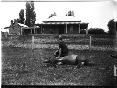 Wodonga & District Historical Society Inc
Negative - Haeusler Glass Negatives Collection - Jack Parker with the pony he taught to do tricks
... of the Wodonga Golf Club in Parkers Road, West Wodonga.... of the Wodonga Golf Club in Parkers Road, West Wodonga. This item ...The Wodonga Historical Society Haeusler Collection provides invaluable insight into life in late nineteenth and early twentieth century north east Victoria. The collection comprises manuscripts, personal artefacts used by the Haeusler family on their farm in Wodonga, and a set of glass negatives which offer a unique visual snapshot of the domestic and social lives of the Haeusler family and local Wodonga community. The Haeusler family migrated from Prussia (Germany) to South Australia in the 1840s and 1850s, before purchasing 100 acres of Crown Land made available under the Victorian Lands Act 1862 (also known as ‘Duffy’s Land Act’) in 1866 in what is now Wodonga West. The Haeusler family were one of several German families to migrate from South Australia to Wodonga in the 1860s. This digital image was produced from one of the glass negatives that form part of the collection, probably taken by Louis Haeusler (b.1887) with the photographic equipment in the Wodonga Historical Society Haeusler Collection. Parker Family - Samuel Skelton Parker, Jack Parker’s father, migrated to Australia from Ballymena, Country Antrim, Ireland in 1884. He married Bridget Cusack from County Clare in 1883. They had children William, James, Jack, Samuel and Rachel. After working on a station in northern NSW, they moved to Barnawartha and set up a butchery and later a bakery. In 1890 the family moved to Wodonga, buying a property in West Wodonga, which he called “Park Hall” after his home in Ireland. The property is now the location of the Wodonga Golf Club in Parkers Road, West Wodonga.This item is unique and has well documented provenance and a known owner. It forms part of a significant and representative historical collection which reflects the local history of Wodonga. It contributes to our understanding of domestic and family life in early twentieth century Wodonga, as well as providing interpretative capacity for themes including local history and social history.Digital image created from the Haeusler Glass negative collection. Jack Parker sitting on his pony which is lying down on the ground. Jack taught this pony to perform several tricks. The Parker family home and some outbuildings are visible in the background. This is a substantial brick house with corrugated iron roof.wodonga pioneers, haeusler family, glass negatives, dry plate photography, parker family wodonga, horsemanship -
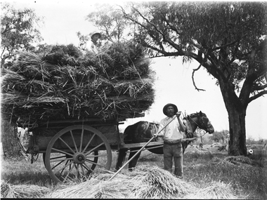 Wodonga & District Historical Society Inc
Negative - Haeusler Glass Negatives Collection - Sam Parker's Farm c1910
... of the Wodonga Golf Club in Parkers Road, West Wodonga.... of the Wodonga Golf Club in Parkers Road, West Wodonga. This item ...The Wodonga Historical Society Haeusler Collection provides invaluable insight into life in late nineteenth and early twentieth century north east Victoria. The collection comprises manuscripts, personal artefacts used by the Haeusler family on their farm in Wodonga, and a set of glass negatives which offer a unique visual snapshot of the domestic and social lives of the Haeusler family and local Wodonga community. The Haeusler family migrated from Prussia (Germany) to South Australia in the 1840s and 1850s, before purchasing 100 acres of Crown Land made available under the Victorian Lands Act 1862 (also known as ‘Duffy’s Land Act’) in 1866 in what is now Wodonga West. The Haeusler family were one of several German families to migrate from South Australia to Wodonga in the 1860s. This digital image was produced from one of the glass negatives that form part of the collection, probably taken by Louis Haeusler (b.1887) with the photographic equipment in the Wodonga Historical Society Haeusler Collection. Parker Family - Samuel Skelton Parker, Jack Parker’s father, migrated to Australia from Ballymena, Country Antrim, Ireland in 1884. He married Bridget Cusack from County Clare in 1883. They had children William, James, Jack, Samuel and Rachel. After working on a station in northern NSW, they moved to Barnawartha and set up a butchery and later a bakery. In 1890 the family moved to Wodonga, buying a property in West Wodonga, which he called “Park Hall” after his home in Ireland. The property is now the location of the Wodonga Golf Club in Parkers Road, West Wodonga.This item is unique and has well documented provenance and a known owner. It forms part of a significant and representative historical collection which reflects the local history of Wodonga. It contributes to our understanding of domestic and family life in early twentieth century Wodonga, as well as providing interpretative capacity for themes including local history and social history.Digital image created from the Haeusler Glass negative collection. A man spreading hay with a rake in the foreground. A horse and cart loaded with hay is behind him.wodonga pioneers, haeusler family, glass negatives, dry plate photography, wodonga families, early farming -
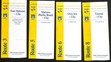 Melbourne Tram Museum
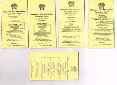
Ephemera - Timetable - The Met - set of 16, The Met, 1993
... 55 - West Coburg - Domain Road interchange - with a note...Melbourne Tram Museum 8 Wallen Road Hawthorn melbourne SSet ...SSet of 16 The Met timetables, diagrammatic map, major stops and contact details. All dated May 1993 unless noted otherwise. 1 - Route 3 - East Malvern - City with a note that route 377 bus service replaces trams on Sunday. 2 - Route 5 - Malvern (Burke Rd) - City 3 - Route 6 - Glen Iris - City 4 - Route 8 - Toorak - City 5 - Route 10 - Sth Melbourne Beach and St Kilda Beach - West Preston 6 - Route 19 - North Coburg - City with a note that route 319 bus service to Gowrie and Upfield was included - ran Saturday afternoons and Sundays only. 7 - Route 42 - Mont Albert - City 8 - Route 48 - North Balwyn - City 9 - Route 55 - West Coburg - Domain Road interchange - with a note that route 68 operates via Elizabeth St on Sunday. 10 - Route 57- West Maribyrnong - City - with a note that route 357 bus services replaces trams on Sunday 11 - Route 59 - Airport West - City 12 - Route 64 - East Brighton - City 13 - Route 69 - Kew (Cotham Rd) - St Kilda Beach via Glenferrie Road 14 - Route 70 - Wattle Park - Princes Bridge 15 - Route 72 - Camberwell - City 16 - Route 82 - Moonee Ponds - Footscray and that route 223 bus replaces trams on Saturday afternoons and all day Sunday,Yields information about some of The Met tram services May 1993Set of 16 The Met timetables, DL size, printed in two colours.timetables, the met, route 8, route 3, route 5, route 6, route 10, route 19, route 42, route 48, route 55, route 57, route 59, route 64, route 69, route 70, route 72, route 82 -
 Eltham District Historical Society Inc
Photograph - Digital Photograph, Marguerite Marshall, Alan Marshall by Marcus Skipper (1995) outside Eltham Library, Panther Place, Eltham, 11 October 2006
... of a house at Park West Road, Eltham, owned by his older sister... of a house at Park West Road, Eltham, owned by his older sister ...Sculture in bronze of Alan Marshall by Marcus Skipper, 1995 Alan Marshall, AM., O.B.E., Hon.LL,D. (1902-1984) was born at Noorat, Victoria and became one of Australia's most famous authors. His association with the Eltham area began in 1920 when he started his first job as a junior clerk at the Eltham Shire Offices, Kangaroo Ground. In the 1940's he spent some time living at Research. From 1955 he lived in Eltham for nearly 20 years. Disabilities resulting from polio as a young child did not prevent a wide range of experiences. Alan's occupations have been listed as clerk, night watchman, fortune teller, freelance journalist and author. He has been patron of many disadvantaged Children's Societies. Alan's books are numerous and include novels, short stories, children's books, history and travel. Among the best known are his autobiographies "I Can Jump Puddles" and "This is the Grass". Others include "These are My People", "Ourselves Writ Strange", "People of the Dreamtime"; "The Gay Provider" and "Wild Red Horses". In 1971 he wrote the Centenary History of the Shire of Eltham, "Pioneers and Painters". Covered under National Trust of Australia (Victoria), State significance. Published: Nillumbik Now and Then / Marguerite Marshall 2008; photographs Alan King with Marguerite Marshall.; p159 Outside the Eltham Library a bronze figure of a short one-legged man with a crutch invites people to the world of literature. The bronze statue, by Marcus Skipper, is of author Alan Marshall, who is famed for his autobiography I Can Jump Puddles, about growing up and overcoming the effects of polio. That plucky little boy later lived in the Nillumbik district for more than 50 years, and on his death in 1984, was buried in the Nillumbik Cemetery at Diamond Creek. Although a hugely successful author, his grave is modest with only a tiny boulder and simple bronze plaque on a grassed plot. From 1955 to 1972 Marshall lived in a tiny fibro-cement bungalow at the rear of a house at Park West Road, Eltham, owned by his older sister, Elsie McConnell. It was there that he wrote most of his autobiographical trilogy and his history of the former Eltham Shire, Pioneers and Painters. His long association with Eltham Shire began in 1918 when his family moved to Diamond Creek. Then in 1920 he began work as a junior clerk at the Eltham Shire Offices on Main Road, Kangaroo Ground near the Yarra Glen Road, while boarding at the hotel next door. Marshall later bought a block of land in Research, which had three bark huts. In one of these he wrote his first book These Are My People. He later sold the land but lived in a caravan there and in 1955 wrote I Can Jump Puddles.1 Proud of its citizen, the Eltham Shire named a park after Marshall at the corner of Main Road and Leanne Drive, Eltham. In 1985 the Shire initiated the Alan Marshall Short Story Award. It was Marshall’s early life in the country that taught him to live courageously in spite of his crippling polio, and he inspired many. This informed his writing – full of courage, championing the battler and love of the bush. Alan Marshall was born in 1902 at Noorat in Western Victoria, as the only son of Billy a drover, horse breaker, hawker and then general store owner. At the age of six, Marshall contracted infantile paralysis and was later hospitalised in Colac for 18 months. With his father’s encouragement, Marshall learnt to swim, wrestle and box, ride a bicycle (downhill), ride a horse and drive a car. Marshall won a scholarship to Stott’s Correspondence College to study accountancy. To help him continue his studies and find employment, his family bought 12 acres (4.8ha), in Ryans Road, Diamond Creek, opposite Windmill Court. There they ran cows, some poultry and an orchard. But life with a disability and during the Depression was hard for Marshall, who for 20 years, endured long periods of unemployment and loneliness and was often exploited at work.2 However, life improved in the 1930s, when he published short stories and articles in newspapers and magazines, including a column of advice to the lovelorn, which he wrote for nearly 20 years. At age 42 Marshall published his first book and in the next 30 years he published more than 20. His most successful book was I Can Jump Puddles, which sold more than three million copies internationally. It was made into a film, released in 1971, by Czechoslovakian director Karel Kachyna. Marshall was one of the first Australians to write about Aborigines who called him Gurrawilla - teller of tales - when he lived with them in Arnhem Land for eight months.3 In 1941 Marshall married Olive Dixon, with whom he had two daughters, Catherine and Jennifer. Marshall and Olive divorced in 1957. In 1972 Marshall was awarded an OBE for his work with the handicapped. He was also awarded an Honorary Doctor of Laws by Melbourne University, an Order of Australia for services to literature and the Soviet Order of Friendship of Peoples.This collection of almost 130 photos about places and people within the Shire of Nillumbik, an urban and rural municipality in Melbourne's north, contributes to an understanding of the history of the Shire. Published in 2008 immediately prior to the Black Saturday bushfires of February 7, 2009, it documents sites that were impacted, and in some cases destroyed by the fires. It includes photographs taken especially for the publication, creating a unique time capsule representing the Shire in the early 21st century. It remains the most recent comprehenesive publication devoted to the Shire's history connecting local residents to the past. nillumbik now and then (marshall-king) collection, alan marshall, art in public places, eltham, eltham library, marcus skipper, panther place, public art, sculpture -
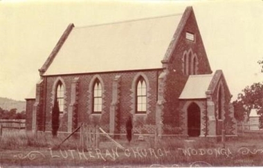 Wodonga & District Historical Society Inc
Photograph - Saint John's Lutheran Church, Wodonga
... Lutheran College in Drage Road, West Wodonga. The new Saint John’s... Lutheran College in Drage Road, West Wodonga. The new Saint John’s ...From the mid-1860s families of German ancestry arrived in the Wodonga district, travelling in groups from South Australia. The majority of these people were of the Lutheran religion. At first there was no Lutheran pastor or church in the area and they held services under the gum trees or in their homes once they had been built. The early arrivals included the Haeusler, Klinge, Bartel, Rothe and Paech families. They were later joined by members of the Muller, Lange, Pumpa, Lobbe, Heckendorf, Zeinert, Schubert, Schuster, Schubert and Terlich families amongst others. The first Lutheran Church was built in Havelock Street, Wodonga and was dedicated in 1875. This building was used for approximately 90 years until it was demolished and replaced by a temporary building and then a second church which was dedicated in 1978. The Ovens and Murray Advertiser on 4th August 1874 reported "The Rev. Goessling pastor of the German Lutheran Church, Gerogery has laid the foundation stone of the new church for the members of his denomination residing at Wodonga, in accordance with the rights of the church. The building was to be 30 feet by 20 feet and 14 feet high, of brick with white facings and Gothic windows. There was to be a porch and vestry, one at either end, measuring 8 feet by 10 feet". Plans were initiated to build a new church from the late 1990s. After many years of planning and hard work, the last service in the Saint John’s Lutheran Church in Havelock Street was held on Sunday 7th May 2023 and a new Church was constructed. From 14th May 2023 the Parish held its worship services in Luther Hall at Victory Lutheran College in Drage Road, West Wodonga. The new Saint John’s Church was consecrated on 18 August 2024.This photo is significant because it depicts the original Lutheran Church in Wodonga.A black and white photograph of an old stone church building.Lutheran Church Wodongawodonga churches, lutheran church wodonga -
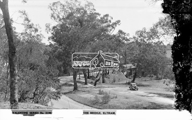 Eltham District Historical Society Inc
Negative - Photograph, The Rose Stereograph Company, The Bridge, Eltham, c.1939
... Looking west across the Main Road Bridge over the Diamond... melbourne Looking west across the Main Road Bridge over the Diamond ...Looking west across the Main Road Bridge over the Diamond Creek at Eltham, c.1939. The car in the foreground, possibly the photographer's, is a Ford Model C Ten built by Ford UK between 1934 and 1937. The Model C was released in Australia in 1935. The Ford Model C Ten is a car that was built by Ford UK between 1934 and 1937. The Model C was released in Australia in 1935 https://en.wikipedia.org/wiki/Ford_Model_C_Ten This glass plate negative was used to manufacture postcards (1:1 printing) for commercial sale by the Rose Sterograph Company and its subsidiaries. George Rose founded the Rose Stereograph Company in 1880 and was joined by Herbert (Bert) Cutts in the early 20th Century. The pair formed a lifetime working partnership and strong personal friendship. Assisted by George’s two sons, Herbert George and Walter, and later by Neil Cutts, the Rose Stereograph Company continued its operations for more than 140 years. The company was initially built on stereographs, but as cinema took over and stereographs fell out of fashion, the Rose Stereograph Company developed Australia’s first commercially viable photographic postcard business. Specialising in postcards of iconic historical moments and significant landmarks, The Rose Stereograph Company became a staple of the Australian travel industry.This remarkable collection of glass plate negatives, transparencies, and postcards – arguably Australia’s most significant photography collection outside of public hands – has been passed down through the generations, surviving war, relocation, and the harsh Victorian climate. The historic Rose Stereograph collection is the culmination of George Rose’s dream of capturing and preserving precious moments in time and remains the legacy of the Rose and Cutts families. It is with great sadness that the Cutts family says goodbye to a collection that spans five generations and 140 years. The Cutts family understands that for these historically important pieces to rest with one family is to deny others the pleasure of their custodianship.Glass Plate Negative Size: 9 x 13.9 cmThe Bridge, Eltham, Valentine Series No. 3196, Copyrightpeter and elizabeth pidgeon collection, bridge, cars, diamond creek (creek), eltham, eltham south, ford model c ten, glass plate negative, main road, main road bridge, motor vehicles, postcard, rose stereograph, rose stereograph company, valentine series postcard -
 Bendigo Historical Society Inc.
Document - BOARD OF WORKS, MELBOURNE: CONTRACTS ACCEPTED & LAND SALES FOR 1860
... ; Removal of Toll-gate from Mount Alexander Road and re-erection...; Construction of 2870 chains of Lower Western Road, west of Camperdown ...Page 2223 titled Contracts Accepted - (Series 1860). Contracts accepted are for Raising and removing sunken ship Marilla; Removal of Toll-gate from Mount Alexander Road and re-erection of same at Middle Gully; Erection of toll-house on Melbourne/Ballarat Road near Ballan; Erection of toll-house on Bendigo Road at Kangaroo Flat; Castlemaine to Ballarat - Erection of toll-house at Campbell's Creek; Construction of 2870 chains of Lower Western Road, west of Camperdown; Erection of two bridges and other improvements on the Clunes to Amherst Road; Erection of timber bridge, & c., over Two-mile Creek - Beechworth to Bowman Forest; Formation of roadway at head of Buckland Gap - Beechworth to Bowman Forest; Construction of culvert, & c., Rowe's Creek - Beechworth to Bowman Forest; Ararat and South-western sea-board road - erection of bridge over Dennicull Creek and other improvements. Land Sales - 4 Lots - Elsternwick, parish of Prahran, County of Bourke; 2 Lots - Dandenong, County of Bourke; 20 Lots - Lillydale, Parish of Yering, County of Evelyn, 1 suburban Lot - County of Evelyn, Parish of Yering; 1 Allotment - Romsey, County of Bourke, Parish of Lancefield; 5 Lots - County of Mornington, Parish of Langwarrin, and 2 Lots - County of Mornington, Parish of Fingal. Lots to be sold at the Auction Rooms of Mr. William Perry, Great Collins Street, Melbourne. A F A Greaves, President, Office of the Board of Land and Works, Melbourne.bridge, construction, timber bridges, board of works, melbourne - contracts accepted & land sales, 'marilla', f m pingree, jno r bailey, robert heron, john gray, donald ross, hector mclean, c j glynn and co, john nicholls and co, michael cleary, thomas cairncross, brown and gibson, queen victoria, mr william perry, mr de castella, willoughby, barker, a f a greeves, board of land and works melbourne -
 Melbourne Tram Museum
Ephemera - Timetable, Melbourne & Metropolitan Tramways Board (MMTB), "Running Timetable and Locations of Recording Clocks", Jun. 1973
... Maribyrnong Moreland - St Kilda Beach West Coburg - Domain Road... Maribyrnong Moreland - St Kilda Beach West Coburg - Domain Road ...Set of photocopies of timetable information titled "Running Timetable and Locations of Recording Clocks" for various tram and bus routes - dated June 1973, signed R. C. Drummond Traffic Manager. Gives running times for sections during various parts of the day, early am, am peak, mid period, pm peak, weekdays, Saturdays and Sundays, and evening and the location of Bundy Clocks. Photocopied or retyped by donor 2016. 1442.1 - two sheets copied onto A4 paper and scanned to a pdf file. East Brighton - City via Swanston Carnegie - City East Malvern - City East Brighton - City - Dudley St Glen Iris -City Malvern Burke Road - City Camberwell - City via William St Camberwell - City via Swanston St Burwood - Spencer St Toorak - City Weekdays North Balwyn - City Wattle Park - Princes Bridge East Preston - City West Preston - St Kilda Beach Essendon Aerodrome - City West Maribyrnong Moreland - St Kilda Beach West Coburg - Domain Road North Coburg - City East Coburg - South Melbourne Beach. On A5 sheets - one large scan Carnegie - City - June 1973 Bulleen to Garden City - 18 June 1972 Bulleen to Garden City - Nov. 1963 East Brighton - City - Dudley St - Nov. 1968 East Brighton - City - via Swanston St - June 1973.trams, tramways, timetables, schedules, bundy clock, mmtb -
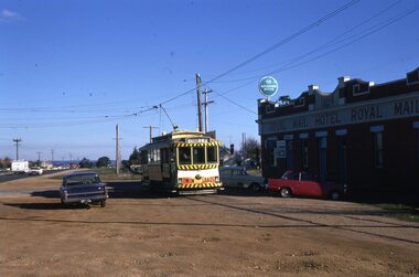 Ballarat Tramway Museum
Slide - 35mm slide/s - set of 6, Noel Simons, 22/05/1971 12:00:00 AM
... a motor cyclist stopped for tram and shows tram stop on the west... a motor cyclist stopped for tram and shows tram stop on the west ...Set of 6 Kodachrome transparencies taken on 22/5/1971. 1171.1 - Tram 33 at Sebastopol terminus, showing destination of Lydiard St. Nth, with Royal Mail Hotel in the background and three parked cars. Tram has "Twin Lakes" sign on front dash. 1171.2 - as for 1171.1 but taken from other side of tram, has hotel in part of photo. Shows arrangement of tram terminus signs on a pole in the background. 1171.3 - Tram 26 just after arrival at the Lydiard St. terminus, with passengers getting off and driver about to swap ends. Destination has been changed to Sebastopol. Has Lydiard St. shelter in the right edge of the photo. 1171.4 - as for 1171.3 - but with pole turned and looking back along street towards city. Shows the undulating nature of the street. 1171.5 - Tram 26 outbound in Albert St. for Sebastopol, crossing the street near Ophir St. Has a motor cyclist stopped for tram and shows tram stop on the west side of the road. 1171.6 - Tram 26, close up of tram at the Sebastopol terminus with two cars parked along side. Tram has destination of Lydiard St. Nth.1171.1 - "No. 33 at Sebastopol Terminus" and initials "BC" in bottom left hand corner. 1171.2 - "No. 33 at Sebastopol Terminus" and initials "BC" in bottom left hand corner. 1171.3 - "No. 26 at Lydiard St. North terminus" and initials "BC" in bottom left hand corner. 1171.4 - "No. 26 at Lydiard St. North terminus" and initials "BC" in bottom left hand corner. 1171.5 - "No. 26 crossing from left side of Albert St. Sebastopol to right side near Ophir St." and initials "BC" in bottom left hand corner. 1171.6 - No. 26 at Sebastopol Terminus" and initials "BC" in bottom left hand corner. All slides have date stamp of "22 May 1971" in purple ink and Kodak developing date of "Jun 71M7" in red ink. tramways, trams, sebastopol, lydiard st nth, royal mail hotel, tram stops, tram 33, tram 26 -
 Melbourne Tram Museum
Ephemera - Timetable/s, Melbourne & Metropolitan Tramways Board (MMTB), "MMTB Tram Timetables", 1975
... .5 - Route 55, 56, 68 - West Coburg - City - Domain Road... 55, 56, 68 - West Coburg - City - Domain Road - May 1975 .6 ...Set of 9 MMTB Tram timetables, folded sheets, generally 10 sections, providing timetables for specific routes, day of week giving information on tram times at specific time points, route map, sections and fares and organisation address - 616 Little Collins St. Melbourne. All printed on yellow paper unless noted otherwise. .1 - Route 3 - East Malvern 3 - Bus Route Sundays Only, Feb. 1975 .2 - Route 5, 35 - Malvern - City .3 - Route 6, 7, 36 - Glen Iris - City .4 - Route 19, 18, 20 - North Coburg - City and Sundays only - Fawkner to Gowrie, Upfield - May 1975 .5 - Route 55, 56, 68 - West Coburg - City - Domain Road - May 1975 .6 - Route 57, 54, 60, 58 and 50 - West Maribyrnong - City - Feb. 1975 .7 - Route 64, 65, 62, 61 - East Brighton - City - June 1975 .8 - Route 66, 67 and 37 - Carnegie - City - June 1975 .9 - Route 82 - Footscray - Highpoint West - Moonee Ponds (Bus service Saturday afternoons and Sundays - November 1975. See Reg Item 2886 for a tramway check ticket for use on the Upfield line.trams, tramways, mmtb, timetables, melbourne, fares, upfield, bus replacement, route 3, route 5, route 6, route 7, route 18, route 19, route 20, route 35, route 36, route 37, route 50, route 54, route 55, route 56, route 57, route 58, route 60, route 61, route 62, route 64, route 65, route 66, route 67, route 68, route 82 -
 Ballarat Tramway Museum
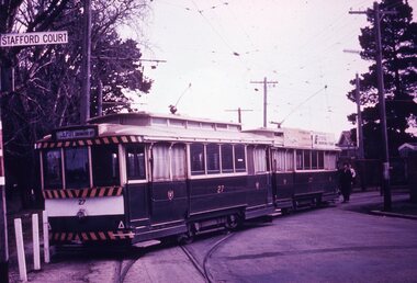
Slide - 35mm slide/s - set of 7, Noel Simons, 1970's
... closure as a bus stop sign has been positioned on the west side... of the road. No. 39 showing destination of "Gardens via Sturt St. West ...Set of 7 transparencies taken undated (appear to be 1970 or 71) on PAKON mounts. Also possibly copy slides as quality is poorish. 1175.1 - No. 27 has derailed at Depot, across Wendouree Parade, and No. 33 appears to be about to try and tow it back on. Wendouree Parade totally blocked. Adjacent pole has tram stop sign and has "Stafford Court" street sign mounted on it. 1175.2 - No. 43 at corner of Drummond St. South and Dana Street, with destination Lydiard St. North. 1175.3 - No. 42 (Mt Pleasant) and 21 (Gardens via Sturt St. West) crossing at Gardens Loop. 1175.4 - No. 42 bound for Lydiard St. Nth at intersection with Macarthur St. Shows the retaining wall for the cutting on the east side of Lydiard St. Nth. 1175.5 - No. 43 at corner of Lydiard St and Sturt St., at city terminus showing "Special" and tram 35 adjacent to Post Office in Lydiard St. Nth. Photo shows the small tram stop pole at this location and Post Office building. 1175.6 - No. 39 and 26 and 27 at the Mt Pleasant terminus. Near closure as a bus stop sign has been positioned on the west side of the road. No. 39 showing destination of "Gardens via Sturt St. West" 1175.7 - Nos 21 and 34 crossing at the Grant St. loop in Barkly St. 21 has destination of Mt Pleasant, while 34, - Gardens via Sturt St. West"All information on typed small white labels, on the top of the slides using black ink. 1175.1 - "27 derailed and 33 at depot" 1175.2 - "43 at cnr Drummond & Dana Sts" 1175.3 - "21 and 42 Gardens Terminus" 1175.4 - "42 at cnr Macarthur & Lydiard" 1175.5 - "43 & 35 at Post Office" 1175.6 - "39, 26 and 27 at Mt Pleasant" 1175.7 - "21 & 34 at Grant St"tramways, trams, wendouree parade, depot, accidents, derailments, drummond st. sth, gardens loop, post office, mt pleasant, grant st., tram 21, tram 26, tram 27, tram 33, tram 35, tram 42, tram 43 -
 Eltham District Historical Society Inc
Photograph (Item) - Print, Craig Price, Old Bootmakers Shop in Main Road, Eltham - Eltham's history worth preserving, 1988
... of the Dalton Street road reserve west of Main Road (now present-day... of the Dalton Street road reserve west of Main Road (now present-day ...701 Main Road, Eltham Situated originally on the corner of the Dalton Street road reserve west of Main Road (now present-day Wingrove Park Trail), the former Jarrold Cottage (White Cloud) was purchased by Lena Skipper following Thekla Jarrold's death in 1943. It was built by William Jarrold in the early 1850s and was here that he married Hannah Coleman in 1856. The Bootmaker's shop was built by Thekla Jarrold in 1930 for use by her friend, John Clark, a local photographer who had boarded with the Jarrold family since about 1910. In 1930 he changed profession to a bootmaker and leather worker. The shop is one of only three remaining early 20th century shops in what was Little Eltham, the others being present-day San Antionio Barber Shop at 820 Main Road and Cafe Zen Den at 736 Main Road. Craig Price 1988 Entrant No. 148 Ref: Series 34, Items 37, 38, 109, 110 SHIRE OF ELTHAM COMMUNITY PHOTOGRAPHIC SURVEY Photography is an artform which many of us practice, sometimes purely for artistic pursuit, sometimes to record the people and events in our lives. In 1988, as part of a local Bicentennial project, the Shire of Eltham conducted the Eltham Community Photographic Survey. Up to 100 entries were to be selected by a panel of photographers for entry into the Eltham Photographic Survey Exhibition. Entries had to be submitted by May 13, 1988. Entrants whose images were selected for the exhibition were contacted and requested to further submit an entry form providing entrant’s name, area of residence, age, and proposed captions. These details were then used to produce labels for the exhibition mounts. Where negatives had not been supplied, these were requested to support the display of printed enlargements mounted on 10” x 8” cardboard. The mounted prints were made available post exhibition for sale at $8.50 each for colour prints and $7.00 for B&W prints. Residents in the Shire were invited to collect a free roll of film and take a photograph of what they either liked or did not like about the area. A total of 160 entrants submitted multiple entries for the exhibition. Of those selected for exhibition, entrants ranged in age from 9 to 70 years. All custom colour and black and white printing for the exhibition was completed by Wattle Studios of Eltham. The Eltham Photographic Survey was jointly auspiced by the Shire of Eltham and Wattle Studios, of 953 Main Road, Eltham. The project was greatly assisted by: • David McRitchie, Media Studies Lecturer Victoria College, Rusden Campus. • Ian and Annette Toohill of Wattle Studios • Tracy Naughton, Eltham Community Arts Officer • Neville Emerson Pty. Ltd. • Superior Press, Eltham • Kodak Australasia Pty. Ltd. • Agfa Gevaert Ltd. • Townsend Colourtech Pty. Ltd. • The Australian Bicentennial Authority • Eleanor Bowers, Secretary, Eltham Arts Council The exhibition was placed on display in the Woolworths Arcade, Eltham between Monday June 6th and Saturday June 11, 1988. It was also intended to hold the exhibition at a venue in the Shire’s North Riding from Monday, June 20 to Friday June 24. It was then displayed at the Were Street Theatre, Montmorency from Friday, June 24 to Thursday, July 7. Series 34: Eltham Community Photographic Survey 1988 - Prints & Documentation Series consists of 117 photographs of Shire scenes taken by members of the community. Items I - 41 are larger photographs mounted on card, which were exhibited. Items 42 - 117 are unmounted copies, alternative takes and other entries. Corresponding negatives contained in Series 35: Eltham Community Photographic Survey 1988 – Negatives which consists of 267 colour and B&W negatives and one colour slide of Shire scenes taken by members of the community. The negatives are arranged by the entrant number of the photographer. The Eltham Community Photographic Survey collection is significant to the local community as it was curated by the local community - ordinary people of all ages - representing what they liked and did not like in the area where they lived. It represents an unfiltered representation of the Shire of Eltham as it was in 1988. It also represents one of many projects as part of the national programme of events and celebrations to commemorate the bicentenary. It is a time capsule of life in the 1980s of this urban and rural municipality in Melbourne's north. Front: Entrant No. and name on printed label Rear: Entrant No., name and address on printed label; also 'Series 34' and the 'Item No.' in pencilshire of eltham archives, bicentennial project, eltham, eltham community photographic survey, eltham photographic survey exhibition, series 34, series 35, bootmaker's shop, craig price, film - kodak ga 100 5095, main road, scan - 35mm negative