Showing 3520 items
matching beaches
-
 Port Melbourne Historical & Preservation Society
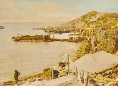
Photograph - Sandridge Beach, 1871
Photographed in 1872 by William PATERSON as one of a series for the Melbourne Exhibition of 1873; original mount hanging in Engineering Department at Port Melbourne Town Hall at 19-9-1994 but now in Port Phillip,City Collection. This set of original prints belonged to Town Clerk Syd ANDERSON, then to his daughter-in-law Phyllis ANDERSON (donor). Accompanied by list of captions, both hand written and typed (the latter a partial listing).View of Beach and piers from Sugar Works, c1871, showing Railway and Town Piers and two jetties in between (caption refers to Donaldson's Jetty), Pier Hotel, gates and some of the yard of the Victorian Sugar Works, and site where Morley's Coal Depot will soon be built, its timber stable and workshop occupied at the time by Carl SEISMAN, mail contractor and owner of the Royal Mail Hotel next door (unseen). The first curved roofed shed can be seen at Town Pier; this remained until demolition in the 1950s. The Post Office Boat House is also visible just before the first small jetty (which is at the place where Alfred LINGHAM's Marine Hotel - the first in the area, 1840 - had its jetty). In the extreme distance Watson's Baths are just visible."P. Anderson" ink, on back.:"7" ink, on face, upper left.piers and wharves - town pier, piers and wharves - railway pier, piers and wharves - donaldson's jetty, sydney sims anderson, town clerks, carl frederick julius seismann, bay street, business and traders - hotels -
 Lara RSL Sub Branch
Framed Photograph of Anzac cove, Anzac Cove 1915
Gallipoli Campaign 1915-6[edit] The first objective for soldiers coming ashore in enemy-held territory was to establish a beachhead, that is a safe section of beach protected from enemy attack where supplies and extra troops could be safely brought ashore. Anzac Cove was always within 1 kilometre (3,300 ft) of the front-line, well within the range of Turkish artillery though spurs from the high ground of Plugge's Plateau, which rose above Arıburnu, provided some protection. General William Birdwood, commander of Anzac, made his headquarters in a gully overlooking the cove, as did the commanders of the New Zealand and Australian Division and the Australian 1st Division. It was on 29 April that General Birdwood recommended that the original landing site between the two headlands be known as "Anzac Cove" and that the surrounding, hitherto nameless, area occupied by his corps be known as "Anzac". Anzac Cove is a small cove on the Gallipoli peninsula in Turkey. It became famous as the site of World War I landing of the ANZACs (Australian and New Zealand Army Corps) on 25 April 1915. The cove is 600 metres (2,000 ft) long, bounded by the headlands of Arıburnu to the north and Little Arıburnu, known as Hell Spit, to the south. Following the landing at Anzac Cove, the beach became the main base for the Australian and New Zealand troops for the eight months of the Gallipoli campaign. Rectangular shaped glass covered picture frame showing Anzac Cove.world war 1,gallipoli,anzac cove,lara r.s.l. ww1 -
 Warrnambool and District Historical Society Inc.
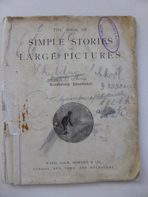
Book, Simple stories & large pictures, Late 19th century
This book was given as a prize to William Giles in the late 19th century. It came from the Skiddaw Sunday (or Sabbath) School. Skiddaw was the home of the Batterbee family and was situated on the old Princes Highway in East Warrnambool near Simpson Street today. The corner here was known as ‘Batterbees Corner’ and there is a Skiddaw Street in the locality today. George Batterbee had a ham and bacon business in Warrnambool. For 36 years his wife, Mary, conducted a Sunday School at Skiddaw (from 1882 to 1918). This Sunday School was under the auspices of St. John’s Presbyterian Church in Warrnambool. Mrs Batterbee was assisted by her daughter Florinda and other teachers. Florinda and her brother Rex were both artists of note. William Giles and his family lived on the Allansford Road. The Logan family farm was in the vicinity of where Logans Beach is today. This book, though tattered and stained, is most important as the only item we have in our collection that is associated with the Skiddaw Sunday School. Situated in a family home, this Presbyterian-sponsored Sunday School operated for 36 years under the direction of Mary Batterbee. This is a book of 32 pages with the cover and perhaps some of the pages missing. It has been stapled but the staples have been removed. The book has large print and illustrations on all the pages. The illustrations have been coloured in by hand. The first page is loose and scribbled on. The pages are very stained and torn in places. The inscription is handwritten in black ink. ‘Skiddaw S. School, Second Prize, Awarded to William Giles for diligence in class, S. Logan, Teacher’. skiddaw, east warrnambool, batterbee family, giles family, logan family, history of warrnambool -
 Bayside Gallery - Bayside City Council Art & Heritage Collection
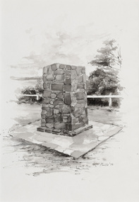
Work on paper - ink and watercolour, Annette Meikle, Moysey Memorial, 1977
In 1977, artist Annette Meikle undertook a commission to illustrate a book recording stories of places and people in the Bayside area. It was published in 1978 as Sandringham Sketchbook, with text by Elizabeth Waters. The sketches were intended to record remaining examples of Bayside’s early architecture and environment, as well as reflect newer architectural changes. Meikle went on to donate 22 of these sketches to Bayside City Council in 2003. Erected in 1964, this stone cairn on Beach Road in Beaumaris marks the site of the wattle and daub cottage of James and Susannah Moysey. James, Susannah and their cousin Nicholas arrived in Victoria in 1844 and leased land on the cliff-top. They built a cottage, cleared the land for sheep and cattle and established vegetable gardens. They later purchased the land and named it Beaumaris Park, derived from the name of the Welsh coastal resort where Edward I built Beau Marais castle.Annette Meikle, Moysey Memorial 1977, ink and watercolour, 35 x 23.5 cm. Bayside City Council Art and Heritage Collection. Donated by the artist, 2003annette meikle, sandringham sketchbook, elizabeth waters, port phillip bay, moysey memorial, coastline, stone cairn, james and susannah moysey, beaumaris -
 Bayside Gallery - Bayside City Council Art & Heritage Collection
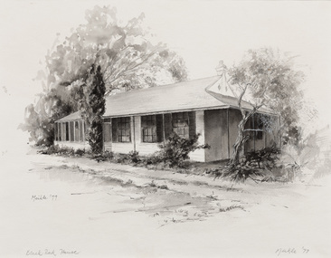
Work on paper - ink and watercolour, Annette Meikle, Black Rock House, 1977
In 1977, artist Annette Meikle undertook a commission to illustrate a book recording stories of places and people in the Bayside area. It was published in 1978 as Sandringham Sketchbook, with text by Elizabeth Waters. The sketches were intended to record remaining examples of Bayside’s early architecture and environment, as well as reflect newer architectural changes. Meikle went on to donate 22 of these sketches to Bayside City Council in 2003. Black Rock House was built in 1858 by wealthy land dealer and politician Charles Hobson Ebden as a holiday home on 112 acres of virgin scrub, taking in the area of present day Balcombe Road, Beach Road and the line of Keating Street. The house included four bedrooms, a cellar, stables and a courtyard enclosed in castle-like sandstone walls. It was named Black Rock House after Black Rock Castle near Dublin, associated with Mrs Ebden’s childhood.Annette Meikle, Black Rock House 1977, ink and watercolour, 33 x 53.5 cm. Bayside City Council Art and Heritage Collection. Donated by the artist, 2003annette meikle, sandringham sketchbook, elizabeth waters, black rock house, black rock, charles hobson ebden, architecture, historic house -
 Vision Australia
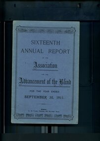
Administrative record - Text, Sixteenth Annual Report of the Association for the Advancement of the Blind 1911, 1911
Annual report of the Association for the Advancement of the Blind outlined activities and events over the year, including membership of 299, 1000 visits were paid during the year, the Public Works department erected a set of steps from the top of the cliff to the sands so that Home residents may be able to access the beach, Railway Permits will now also be honoured on the Prahran-Malvern Electric Tramway and Bay Excursion Steamers, a concert party toured to Egerton, Ballan, Bacchus Marsh, Myrniong and Toolern Vale for the dual purpose of raising awareness and funds for the Association, Mr A Solomon has been appointed as a second Collector to visit Country Towns and with the support of the wife of the Minister for Public Works, Miss Aston and Miss Munce waited on the Lady Mayoress of Melbourne, gave her full support to organise a fund to purchase the land and buildings in Mair Street for the Association.1 volume of printed material with some illustrationsassociation for the advancement of the blind, annual reports -
 Orbost & District Historical Society
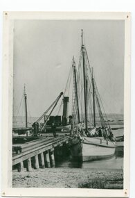
black and white photograph, before 1912
This photo shows the Storm Bird at the end of the jetty and the Wangrabelle in the foreground. Both ships were well known traders. the Wangrabelle became beached and wrecked in 1916 and the Storm Bird became obsolete when the railway from Bairnsdale to Orbost arrived in 1916. (ref. Story of Gippsland Shipping - J.C. Bull) At the start of the river trade goods were shipped from Marlo to Melbourne but when the railway reached Bairnsdale this became unprofitable and the ships plied only between Marlo and Cunninghame. Eventually river transport became economically unviable. The Wongrabelle is still buried in the sands of the entrance of the Snowy River (albeit where the entrance used to be). It took from April 11th 1912 to August 12th 1912 for the loss of the Wongrabelle to be complete, the final entry in the Orbost Shipping Co. records reads:- "The Wongrabelle is completely covered in sand." (ref River, Road, Railway Newsletter O.D.H.S.) This is a pictorial record of a time when the water highways were the only feasible transport mode in sending goods from Orbost and Marlo to Melbourne.A black / white photograph of a ship, sails down, anchored at the Marlo jetty.on back - "M. Gilbert, Wangrabelle at Marlo"storm-bird wangrabelle shipping transport- marlo -
 Warrnambool and District Historical Society Inc.
Document, Map: Lady Bay 1853, 1853
This is one of the earliest surveys and maps of Warrnambool harbor, Lady Bay. Being done in 1853, it shows the depths of the bay area marked in fathoms, currents and directions and areas of rocks around mouth of the Merri and the Western side of the bay as well as a large sand spit to the middle right of the beach region.. It also marks the large areas of seaweed and fuci in the outer bay area. It has the area of Pertobe Lagoon marked and shows the early tracks to the town. The engraving work was done by Tulloch and Brown, with Tulloch being one of the earliest engravers and lithographers in the state of Victoria. He arrived in Melbourne in 1849 and set up business with James Davie Brown in 1853 with Brown being a map engraver. They were awarded bronze and silver medals for their work at the Victorian Industrial Exhibition. He also worked in the vignettes on the Proeschel Map of Victoria.This map is of high historical and comparitive significance as it shows the Lady Bay area prior to the changes that have occurred in the last 160 years with the building of the breakwater. The issue regarding access to Lady Bay remains a current one. The engraver D Tulloch engraved some of the earliest scenes of the goldfields in Ballarat and as such has left a record of a very early and important era in Australian history. Rectangular cream paper with black text. Map area is outlined by fine black lined border. Key in top right hand corner and scale at bottom middle of map.Map is labelled Town of Warrnambool printed at top of map. Small logo at top right corner which has “Hydrographic Department” in circle around an anchor. Lady Bay Warrnambool Surveyed by John Barrow assistant surveyor Engraved by Tulloch & Brown in bottom right corner. Melbourne engraved by order of the legislative Council of Victoria in middle bottom.map, warrnambool, town of warrnambool map 1853, tulloch & brown map 1853, lady bay warrnambool,, warrnambool harbour, warrnambool breakwater, warrnambool beach -
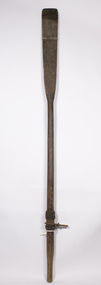 Queenscliffe Maritime Museum
Equipment - Oars
Just off Port Phillip Heads on April 12 1936, a strong wave struck the Nairana, tipping her over for two minutes before she righted herself again. During the horrifying two minutes, four people were drowned, and eight people were injured. The ship was reportedly carrying roughly one tonne of concrete in the hull when she tipped. Reports from the local papers said that it was a tidal wave meanwhile others were saying it was either an earthquake or a total lie. A later paper said that the ship had been caught in a rip at the mouth of the bay, causing the tragedy. The S.S Nairana, was sold for £4,000 (over $170,200 in today’s money!) in 1951 after two years of being stranded on the beach at Port Melbourne, when the moorings broke one night during a storm and drifted ashore, causing her to wreck.After WWI in 1920 she was decommisioned as a seaplane carrier and returned to her Australian owners crossing Bass Strait until she was laid up in 1948.Pair of oars from the Nairanaoars, ss nairana -
 Melbourne Legacy
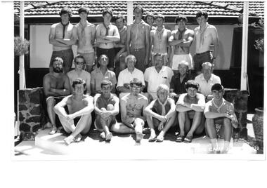
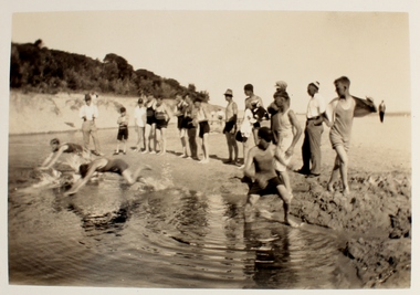
Photograph - Junior legatee outing, Big Camp 1970 at Somers Camp, 1970
A photo of a large group of teenage boys and men from Big Camp, January 1970. Big camp was for older junior Legatees. One of the men appears to be Sir Rohan Delacombe, the Governor of Victoria and patron of Legacy (fourth from the left centre road). Melbourne Legacy provided camps for junior legatees - the children of deceased servicemen. It started with outings to the property of Legacy founder, Legatee Stan Savige, who had a place in Balnarring. Permanent camp buildings were built and with an association with Lord Somers (Governor of Victoria) it was called Somers Camp. The camps gave the children an opportunity of a summer beach holiday with other Legacy children. It came from an envelope with other Big camp photos. The Legacy envelope was marked "P5 Power House" in red pen, and Box 15 in blue pen. The contents will be items 00427 to 00430.A record of Junior Legatee camps.Black and white photo of Legatees and senior boys at Big Camp 1970.Front of photo has text over the photo: "Big Camp Jan___ 1970". On reverse "P5 Legacy / 1970 Big Camp" written in blue pen.somers camp, junior legatee outing, big camp -
 Phillip Island Conservation Society Inc.
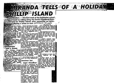
Work on paper - Photocopy of newspaper cutting, Herald and Weekly times, "MIRANDA TELLS OF A HOLIDAY ON/ PHILLIP ISLAND"
Miranda was a very popular journalist of this era, whose homely style appealed to many readers, especially women, her main audience in her writing. Here she talks about renting a new demonstration holiday home (probably a Coldon Home), which, although small, had a 'dream kitchen'. She describes the birds and walk through the wattle to the beach, but also the many blocks for sale and wonders what the island will be like in 10 years time from their visit. Her son drove them to Pyramid Rock where they almost got bogged on the road. They visit the usual spots, which she describes with a combination of curiosity and enjoyment. She also mentions another block fenced off on the main road which was a gift from the ratepayers of Phillip Island, and which the Young Farmers were to plant out for koala trees.This article is significant because thousands of Weekly Times newspaper readers read Miranda’s letter article without fail each edition. She describes renting a house for a holiday, which indicates the move away from family holidays in guest houses. She also describes some of the rough roads in parts of the island at the time. She concentrates on the island’s natural attractions rather than man- made tourist attractions, which is also significant in letting us see why people would visit Phillip Island in that era. Miranda also predicts the explosion of the holiday home owner market which took place soon after, and continues today though in a more controlled way.Photocopy of newspaper article cut out from full page. Cutting has three columns of text, no images. Black text on white paper. Dark areas due to poor photocopyingWEEKLY TIMES / 2/9/65phillip island, miranda, weekly times newspaper, holiday home, phillip island flora and fauna, pyramid rock, phillip island pengiun parade, young farmers, phillip island beaches, cuddly koala bears, phillip island housing estate land sales -
 Melbourne Legacy
Article, Bulletin VALE Legatee Cecil Ernest Waters, 1986
A Vale notice that was published in the Bulletin in 1986 on the death of Legatee Cecil Waters. After the death of his father in WW1 Cecil Waters became a junior legatee from 1926. So he was among the first batch of Junior Legatees. He joined the Intermediate Legacy Club and served a term as President of the ILC. During WW2 he served in the Middle East and South West Pacific area from 1941 to 1946, completing his service as a Captain with the 2/1st Aust Beach Detachment. After his war service he was eligible to join Legacy as a Legatee. He was proposed by Legatee Len Frazer and seconded by Legatee Frank Doolan. He married Stan Savige's daughter, Gwen in 1954 and they had a son Stanley Waters. Ill health caused him to be placed on Reserve in 1962. Gwen died in 1980.A record of the life and service of Legatee Cecil Waters.White A4 paper of a photocopy from the Bulletin of the notice about Legatee Waters.vale, cecil waters -
 Melbourne Legacy
Photograph, Legacy camp, Balnarring East, 1929
One of the earliest camps held for Junior Legatees, showing tents, charabancs and fashions of the day. Legatee Stan Savige had a property in the Balnarring area and some camps were held on his property. Names noted on the back of the photos include: Pat Hanna, Aaron Beattie, Stan Savige, Sandy Lowe, Bill Pearce, Lyn Rule, Donovan Joynt, Carl Carleton, George Collins, Bill Pearce, Rupert Hely, Norman Stafford. Some of these were founding legatees. Melbourne Legacy provided camps for junior legatees - the children of deceased servicemen. It started in the early years of Legacy with outings to the property of Legacy founder, Legatee Stan Savige, who had a place in Balnarring. Permanent camp buildings were built in the 1930s. The camps gave the children an opportunity of a summer beach holiday with other Legacy children.A visual record of a camp run for Junior Legatees, with founder Stan Savige in one of the photographs, showing the accommodation and activities.Folding wallet, brown and cream with black printing, set of sepia photos varying sizes, 1 negative for 00061.7Wallet: 00061.1 “77283” (pencil), Kodak (Australasia) marketing text Photos: 00061.2 “Legacy Camp, Balnarring Xmas 1930/Taken by Aaron Beattie/Pat Hanna rear/Bill Pearce Lfront Lyn Rule/Donovan Joynt Centre Front/Carl Carlton Right Front/Child unknown/extreme left 2 unknown poss. from Bendigo Club” 00061.3 “N 481” 00061.5 “N 481” 00061.6 “Legacy Club Camp Hut/Balnarring East/ 7. Dec 1929” 00061.7 “N 481” 00061.8 “L to R/Stan Savige, George Collins, Bill Pearce/Sandy Lowe Rupert Hely/Norman Stafford/413” 00061.9 “738” 00061.10 “N 481” 00061.11 “N 481” 00061.12 “ Printer Harringtons/4 43” 00061.13 “738”camp, stan savige, founding legatee, somers camp -
 Melbourne Legacy
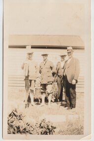
Photograph, Legacy Somers Camp, c1930
A black and white photo of a group of four men, most likely at Somers camp, probably in the 1930s. Second from left is Legatee Stan Savige. One man is holding rowing oars. It shows a building that had been built on Legatee Stan Savige's property. In the early years, Legacy organised outings to the property of Legacy founder, Legatee Stan Savige, who had a place in Balnarring close to the beach. Permanent camp buildings were built in 1930. In 1930 Lord Somers (Governor of Victoria) also started a camp at a nearby property and the area was renamed Somers. Legacy Somers Camps continued intermittently at Stan's property until it was decided in 1951 to make other arrangements for holidays. This photo was with a group of photos from around the 1930s from the early days of Legacy, including cricket team, football team, and camps at Balnarring/Somers (saved as 01915 to 01934).Legatee Savige's property at Balnarring became very important for Legacy providing outings and camps for junior legatees.Black and white photo of four men, including Stan Savige.Stamped on reverse with 'Kodak print' and 'X 657' in grey ink. Velox paper.legacy somers camp, savige property -
 Melbourne Legacy
Photograph, Legacy Somers Camp, c1930
Three black and white photos of junior legatee Jim McGregor at Somers camp, probably in the 1930s. In two of them he appears to be holding a pick axe. It could be when work was being done at Somers camp in the early 1930s. In the early years, Legacy organised outings to the property of Legacy founder, Legatee Stan Savige, who had a place in Balnarring close to the beach. Permanent camp buildings were built in 1930. In 1930 Lord Somers (Governor of Victoria) also started a camp at a nearby property and the area was renamed Somers. Legacy Somers Camps continued intermittently at Stan's property until it was decided in 1951 to make other arrangements for holidays. These photos were with a group of photos from around the 1930s from the early days of Legacy, including cricket team, football team, and camps at Balnarring/Somers (saved as 01915 to 01934).Legatee Savige's property at Balnarring became very important for Legacy providing outings and camps for junior legatees.Black and white photo x 3 of a junior legatee called Jim McGregor.Handwritten on 01930.1 'x x Jim McGregor' in blue pen. Stamped 'E63' in purple ink. Handwritten on 01930.2 'Jim McGregor' in blue pen and stamped '39' in black ink. Stamped on 01930.3 'E63' so same film as the first one.junior legatee outing, tents, legacy somers camp, savige property, camps -
 Melbourne Tram Museum
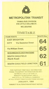
Ephemera - Timetable, Metropolitan Transit Authority (MTA), "Metropolitan Transit Timetables", Jan. 1984
Set of 13 Metropolitan Transit Tram timetables, folded sheets, 8 to 10 sections, providing timetables for specific routes, day of week giving information on tram times at specific time points, route map, sections and fares and Transport Information Centre telephone number. All printed on yellow paper. .1 - Route 64 (65 via William St), 62 and 61 - dated January 1984. .2 - Route 3 (Darling Road via Swanston St) with route 377 bus on Sundays via Batman Ave. - July 1984 .3 - Route 5 - Malvern Burke Road - City - July 1984. Cover was printed showing route 35 via William St, but has been crossed out in pencil. .4 - Route 6 (Glen Iris - City) and Route 7 (Malvern Town Hall) - July 1984. Cover was printed showing route 36 via William St, but has been crossed out in pencil. .5 - Route 8 - Toorak - City - June 1984. Cover was printed showing route 38 via William St, but has been crossed out in pencil. .6 - Route 10 and 11 West Preston via Collins St and Route 13 via Latrobe St - March 1985. .7 - Route 10 and 12 - South Melbourne and St Kilda Beach - City (Brunswick St) via Collins St and route 17 - Park and Clarendon Sts. - Sept 1984 .8 - Route 15 and 22 - Moreland to City, July 1983 .9 - Route 15, 16 and 55 - St Kilda Beach to City via Swanston St - July 1983. Cover was printed showing route 53 via William St, but has been crossed out in pencil. .10 - Route 19 (Coburg), 18 (Brunswick) and 20 (Bell St) - City - August 1984 .11 - Routes 59 (Airport West), 49 (Niddrie), 52 (Bulla Road), 51 (Essendon Station) and 81 (Essendon Depot) - April 1985. .12 - Route 69 - Kew Cotham Road to St Kilda Beach - Sept. 1984 .13 - Route 72 (Camberwell - City), 32 via William St and route 73 (Camberwell Junction) - August 1984. .14 - Route 1 and 21 - East Coburg - City - August 1983. Full Image of .10 added 9/4/17 following a query about route 19 timetables - see image i6trams, tramways, the met, timetables, melbourne, latrobe st, la trobe st, mta, buses, route 64, route 65, route 3, route 5, route 6, route 8, route 10, route 11, route 12, route 13, route 17, route 15, route 22, route 16, route 55, route 19, route 18, route 20, route 59, route 49, route 52, route 51, route 81, route 69, route 72, route 32, route 73, route 1, route 21 -
 Flagstaff Hill Maritime Museum and Village
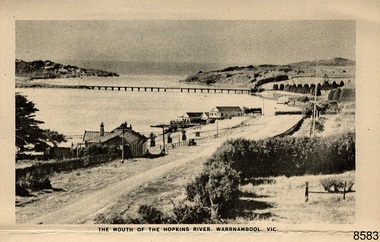
Postcard - Postcard Folder - scenes, George Rose, Rose Stereographic Company, Rose Series Picturesque Views of Warrambool Australia [Warrnambool], 1880-1942
This postcard folder contains lithographs of photographs taken locally by Georg Rose between 1880 and 1942. He reproduced them at his company's premises, the Rose Stereographic Company at Armadale, Victoria. The postcard folder was purchased as a Warrnambool souvenir by the donor's parents around 1945 to 1950. Interestingly, the city on the cover is printed as "Warrambool", which is a location in New South Wales, but the postcards within all have the locations and text of Warrnambool. The photographs include the 'new' concrete bridge, built in 1922 to replace the original bridge, built in 1872. The boathouses belonging to Proudfoots and to Flett/Fanny Nelson are also pictured on the Hopkins River mouth. The twelve photographs included locations connected to other items in our Collection. The photographs are titled: - b. The Avenue and War Memorial. Warrnambool. Vic. c. The Blow-hole. Thunder Point. Warrnambool. Vic. d. Botanical Gardens. Warrnambool. Vic. e. Eagle Rock. Warrnambool. Vic. f. The New Concrete Bridge and Breakwater. Warrnambool. Vic. g. Liebig Street. Warrnambool. Vic. h. Looking to Thunder Point. Warrnambool. Vic. i. The Beach. Warrnambool. Vic. j. Hopkins Falls. Warrnambool. Vic. k. Shelly Beach. Warrnambool. Vic. l. The Mouth of the Hopkins River. Warrnambool. Vic. m. Panorama of Warrnambool. Vic. [Kepler Street towards Presbyterian Church on Spence St] George Rose, 1861-1942: - famous for his Late 19th and early 20th century photography. He was born in Clunes, Victoria, and was in his 20th year when he founded Rose Stereograph Company in 1880. He took the opportunity of a popular trend of the times to produce stereographs, pairs of almost duplicate photographs which appeared to be in 3D when viewed in a handheld stereo viewer. By the 1920s these lost their popularity, so he used his photographic skills to produce cards and postcards of scenes and people. The photographs in this postcard folder were taken between 1880 and 1942 by the renowned Victorian photographer George Rose. The locations match photographs and postcards in our collection that were taken at different times. A comparison between them shows the changes over time in the land and bay, the buildings and other structures, transportation and even the fashions of the times, building the story of our local history.The postcard folder has a blue-grey textured rectangular card cover with a sketch of a rose on the front along with the name of the postcard series. the location of the series' focus, the producer's details and lines for adding an address. The folded cover contains a long, concertinaed page with six titled photographs on each side, totalling twelve in all. Interestingly, the cover has the location name of "Warrambool", a place in NSW, instead of Warrnambool, the location of all of the photographs inside. The folder contains scenes from Warrnambool and nearby popular areas including Lady Bay, Port of Warrnambool, Warrnambool Breakwater, Viaduct, Merri River Footbridge, the Hopkins River Mouth, with Proudfoot’s and the Fanny Nelson/Flett boathouses. The cover has a sketch of a rose and inscriptions. The photographs for the lithographs were taken prior between 1880 and 1942 by well-known Victorian photographer, George Rose, Rose Stereograph Company of Armadale, Victoria.Image: [Rose with rosebud and leaves] Printed: "Rose Series / Picturesque Views of / WARRAMBOOL / AUSTRALIA" [correct spelling is WARRNAMBOOL] "PUBLISHED BY / ROSE STEREOGRAPH CO / ARMADALE. VIC." Printed lines (3) for an address. Printed rectangle [ ] for attaching a stamp.flagstaff hill maritime museum and village, great ocean road, shipwreck coast, warrnambool, flagstaff hill, flagstaff hill maritime museum, flagstaff hill maritime village, warramble, postcard, postcard folder, warrnambool scenes, picturesque views of warrnambool, picturesque views of warramble, lady bay, port of warrnambool, breakwater, warrnambool breakwater, viaduct, merri river footbridge, merri river suspension bridge, suspension footbridge, merri river mouth, hopkins river mouth, proudfoot's, fanny nelson, nelson's boatsheds, nelson's boathouse, boathouse, hopkins river boathouses, flett's boathouse, flett, george rose, image of a rose, rose series, rose stereograph co, rose stereographic company, lighograph, armadale victoria, lady bay beach, beach scene, lower light, concrete footbridge, 1922 footbridge, viaduct road, rose postcard, new concrete bridge, 1945, 1890, 1922, small footbridge, 1872 footbridge, 1872, merri river estuary, stingray bay -
 Clayton RSL Sub Branch
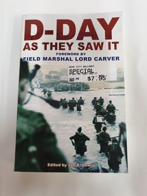
soft cover non-fiction book, D-Day As They Saw It, 1994
The extraordinary and compelling story of June 6, 1944 and the battle for Normandy is told here through first-hand testimonies from civilians and soldiers on both sides. D-Day: As They Saw It features classic accounts by soldiers such as Rommel and Bradley, together with frontline reports by some of the world's finest authors and war correspondents, including Ernest Hemingway and Alan Melville. Published to celebrate the 60th anniversary of the Normandy landings, highlights of this unique collection include the break-out from Omaha beach as told by the GI who led it, a French housewife's story of what it was like to wake up to the invasion, German soldiers' accounts of finding themselves facing the biggest seaborne invasion in history, a view from the command post by a member of Eisenhower's staff, combat reports, diaries and letters of British veterans of all forces and services, and accounts of the follow-up battle for Normandy, one of the bloodiest struggles of the warForeword by Field Marshall Lord Carversoft cover book -
 Orbost & District Historical Society
plan, before 1948
Drainage infrastructure was developed and maintained in this region by the Snowy River Improvement Trust. The Trust was administered by a local committee and its activities funded by a local rate charged on the farmers and land owners in the Trust’s designated district. The level of the rate charged by the Trust was designed to be proportionate to the benefit derived from the works undertaken. Financial assistance was provided by the State Government from time to time for specific projects such as post flood repairs but not for new capital works. The Trust undertook new drainage and river management works including tree planting, rock beach construction and servicing of the drains and flood gates. The Trust also provided a personal flood warning service to the farmers in its district. The Trust ceased to operate in 1997 with the advent of the East Gippsland Catchment Management Authority. The infrastructure developed by the Trust continues to provide a service to the farmers in the region. (ref. 4 East Gippsland CMA Submission to Inquiry into Flood Mitigation Infrastructure in Victoria) This plan is significant as a historical document. The Snowy River Improvement Trust was vital to the Orbost district because of its ability to apply local knowledge and to engage the local farming community.A large plan of divisions of land for the purpose of levying the Snowy River Improvement District - Bete Bolong, Orbost, Waygara, Newmerella and Orbost East. The properties are coloured according to levy amount. The scale is 1" - 20 chains. snowy-river-improvement-trust -
 Orbost & District Historical Society
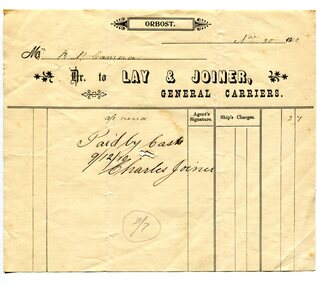
receipt docket, November 30, 1910
Mr Fred Lay, along with his father and brothers, owned the local carrier business with Mr Charlie Joiner as a business partner. They used a horse and cart to transport goods from the railway station into Orbost . In about 1907-08 Mr. Charles Joiner and Mr. Alf Lay came together and conducted a regular service — Mr. Lay at Lakes with a five horse team (because he had to travel the beach at Lake Tyers) and Mr. Joiner, at Orbost, with four horses. The two met half way and changed wagons. Asked why they did this it was said they met every boat and were at the jetty every day. This was why they cornered most of the inward loadings. (ref. River Trading on the Snowy, John Phillips) Later the business was sold to Mr David Williams. Robert Pullar Cameron was a Shire Councillor for many years. He married Penuel Hossack and had a family of James, Flora, Penuel and Alex.This item is an example of a book keeping document used by an early Orbost Business. It is a useful research item.A white receipt docket with black lines and print from Lay & Joiner, General Carriers to R. Cameron.on front - "Paid by Cash"cameron-robert-pullar lay-&-joiner-carriers transport document-receipt -
Bialik College
Document (series) - Drama and musical production programs and promotional material, 1980s-2010s
1990s, 2000s, 2010s1990s, 2000s, 2010s -
 Melbourne Legacy
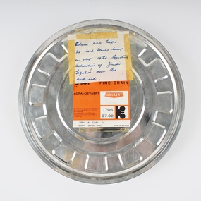
Film, Lord Somers Camp - Nov 1972, 1972
16mm colour film with no sound - the second B&W workprint not digitised. 13 min 24 sec. Begins with the flag raising ceremony at Somers Camp and then moves to Westernport Airfield where the boys are seen going for flights in Cessnas whilst others learn archery and play volleyball. Moves on to beach activities and dinghy sailing supervised by Legatees. Back at Somers there is a comic performance of Goldilocks in front of a large audience of younger Junior Legatees and the supervising Legatees, which ends with a bearded Goldilocks being taken away in a police car. A service in the bush chapel is then shown before we see the older boys throwing one of their number off a jetty. A volleyball game completes the film. There is no indication of date, but the clothes seem to be 1960s/70s. This film has been digitised to preserve its content. Melbourne Legacy gratefully acknowledges the support of the Victorian Government and Public Record Office Victoria for making this possible.Depicts the work done by Legacy volunteers in helping Legacy families of the time. Volunteer groups such as Legacy supported those in need at a time when government assistance was much less than it is today.Two 16mm black and white films. One film is wrapped in brown paper. Under the wrapping the film is enclosed in a plasic wrap.Canister - patterned Agfa _ Gefaert Fine Grain. / Key No. 170627_02 'Not to be screened under any circumstances! Only to be handled by an expert with the approprate facilities for handling this type of film' on the brown wrapping paper, probably to keep a good copy.somers camp, camp -
 Melbourne Legacy
Newsletter, Camp Savige Newsletter
Undated but stapled to a further copy of 00130 which was dated 'Xmas 1932'. Pages headed 'Camp Savige, Wednesday' indicate that it was created for a camp at Stan Savige's property, recounting the cricket competition between the Dark Blues, Light Blues, Green and Orange teams. Written and illustrated by Pat Hanna in a satirical style it was clearly intended to entertain as much as to inform, but the humour would be seen to be heavy handed or not funny at all today. Nevertheless it demonstrates that campers enjoyed their stay. See also 01290 and 01289. In the early years, Legacy organised outings to the property of Legacy founder, Legatee Stan Savige, who had a place in Balnarring close to the beach. Permanent camp buildings were built in 1930. In 1930 Lord Somers (Governor of Victoria) also started a camp at a nearby property and the area was renamed Somers. Legacy Somers Camps continued intermittently at Stan's property until it was decided in 1951 to make other arrangements for holidays.Illustrates the sort of activities considered appropriate to occupy camp participants, and the amateur enthusiasm of the newsletter producers in the early half of the twentieth century.2 typed foolscap sheets black on cream, pencilled correction newsletter, legacy somers camp, savige property, camps -
 Melbourne Legacy
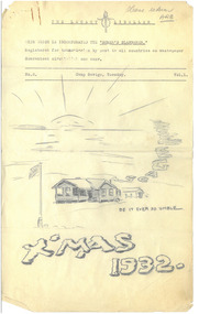
Newsletter, The Legacy Libeller: with which is incorporated "The Somers Slanderer", 1932
Dated 'Xmas 1932'. Pages headed 'Camp Savige, Tuesday' indicate that it was created for a camp at Stan Savige's property. It recounts the cricket competition between the Dark Blues, Light Blues, Green and Orange teams. Written and illustrated by Pat Hanna in a satirical style it was clearly intended to entertain as much as to inform, but the humour would be seen to be heavy handed or not funny at all today. Nevertheless it demonstrates that campers enjoyed their stay at Somers. See also 01289 and 01291. In the early years, Legacy organised outings to the property of Legacy founder, Legatee Stan Savige, who had a place in Balnarring close to the beach. Permanent camp buildings were built in 1930. In 1930 Lord Somers (Governor of Victoria) also started a camp at a nearby property and the area was renamed Somers. Legacy Somers Camps continued intermittently at Stan's property until it was decided in 1951 to make other arrangements for holidays.Illustrates the sort of activities considered appropriate to occupy camp participants, and the amateur enthusiasm of the newsletter producers in the early half of the twentieth century.Foolscap sheets x 3 pages, black on cream, penciled drawings, corrections and linesLegacy symbol hand drawn in pencil. Penciled 'please return ARB'newsletter, camp savige, legacy somers camp, savige property -
 Melbourne Legacy
Newsletter, The Legacy Libeller: with which is incorporated "The Somers Slanderer"
Undated but stapled to a further copy of 00130 which was dated 'Xmas 1932'. Pages headed 'Camp Savige, Monday' indicate that it was created for a camp at Stan Savige's property. It recounts the cricket competition between the Dark Blues, Light Blues, Green and Orange teams. Written and illustrated by Pat Hanna in a satirical style it was clearly intended to entertain as much as to inform, but the humour would be seen to be heavy handed or not funny at all today. Nevertheless it demonstrates that campers enjoyed their stay at Somers. See also 01290 and 01291. In the early years, Legacy organised outings to the property of Legacy founder, Legatee Stan Savige, who had a place in Balnarring close to the beach. Permanent camp buildings were built in 1930. In 1930 Lord Somers (Governor of Victoria) also started a camp at a nearby property and the area was renamed Somers. Legacy Somers Camps continued intermittently at Stan's property until it was decided in 1951 to make other arrangements for holidays.Illustrates the sort of activities considered appropriate to occupy camp participants, and the amateur enthusiasm of the newsletter producers in the early half of the twentieth century.3 typed foolscap sheets black on cream, pencilled corrections and linesLegacy symbol hand drawn in pencilnewsletter, savige property, legacy somers camp, camps -
 Melbourne Legacy
Photograph, Somers Camp, c1930
A black and white photo of a group of people holding camping items in the garden of a house. From other photos it appears to be a house often used for gatherings and may be on Stan Savige's Balnarring property. In the early years, Legacy organised outings to the property of Legacy founder, Legatee Stan Savige, who had a place in Balnarring close to the beach. Permanent camp buildings were built in 1930. In 1930 Lord Somers (Governor of Victoria) also started a camp at a nearby property and the area was renamed Somers. Legacy Somers Camps continued intermittently at Stan's property until it was decided in 1951 to make other arrangements for holidays. This photo was with a group of photos from around the 1930s from the early days of Legacy, including cricket team, football team, and camps at Balnarring/Somers (saved as 01915 to 01934). Mention has been found that the Savige holiday house at Balnarring was next to the campsite and sometimes provided support to the campers.A photo of a group of founding legatees or some of the first junior legatees. Legatee Savige was an important figure in Legacy's history and his property at Balnarring became very important for Legacy providing outings and camps for junior legatees.Black and white photo of a group of people at a house with camping items.Stamped 'Kodak print S 856' on back in grey ink.camp, junior legatee, legacy somers camp, savige property -
 Flagstaff Hill Maritime Museum and Village
EPIRB Transmitter, c. 1970
This distress EPIRB unit (Emergency Position Indication Radio Beacon) was found on the beach at Levy's Point, Warrnambool, in December 2000 by a Warrnambool resident. Local police were alerted at the time. This distress signal unit is a world-wide COSPAS/SARSAT, satellite assisted, SAR (Search and Rescue) system for location of distress transmissions emitted by an EPIRB. Offshore cruising vessels must have such a unit as part of its essential safety equipment. This model EPIRB relies on four satellites with orbit times of approximately 100 minutes. The earlier units relied solely on aircraft flying overhead to detect and forward on the EPIRB’s location to Search And Rescue authorities, whereas this new system utilises satellites. The Lokata Company was established in 1970, designing and manufacturing marine products including communications. The company no longer makes products with the “Lokata” brand. In 2001 Sartech Engineering Ltd. took over the support for the Lokata EPIRB beacons. EPIRB unit; “Emergency Position Indication Radio Beacon” Distress communication unit for sending a distress location transmission in an emergency at sea. The EPIRB is a yellow, rectangular box with dials, buttons, indicator lights and instruction, plus an antenna protruding from the top of the unit. This unit sends a 406P (X) EPIRB, with 406M-Hz frequency, 48 hour duration signal. Made by LOKATA Ltd in England. Remnants of a white label remain on the side. Circa 1970“LO-KATA” moulded into the body. “Model 406” printed on the identifying pane (other required information is undecipherable) flagstaff hill, warrnambool, shipwrecked-coast, flagstaff-hill, flagstaff-hill-maritime-museum, maritime-museum, shipwreck-coast, flagstaff-hill-maritime-village, emergency position indicating radio beacon, epirb, lokata ltd, marine safety equipment, satellite transmitting beacon -
 Australian Commando Association - Victoria
Medal - War Medal- William Alsop 2/10 Commando Squadron, c. 1945
This object was issued to William Donald Alsop for his service in the 2/10 Commando Squadron during the Second World War.This object displays Historic Significance through its connection with William Donald Alsop, his service in the 2/10 Command Squadron and World War Two.The War Medal 1939-45 is cupro-nickel with the crowned effigy of King George VI on the obverse. The reverse has a lion standing on a fallen dragon. The top of the reverse shows the dates 1939 and 1945. The riband is 32 millimetres wide with a 5½ millimetres wide Army red band, a 3 millimetres wide navy blue band, a 6 millimetres wide dark green band, a 3 millimetres wide yellow band, a 6 millimetres wide dark green band, a 3 millimetres wide Royal Air Force blue band and a 5½ millimetres wide Army red band. The forests and beaches of the Pacific are represented by the dark green and yellow bands respectively, while the Royal Navy and Merchant Navy, the Armies and the Air Forces are represented by the dark blue, red and light blue bands respectively.On front of medal, above the lion: 1939/1945 On reverse of medal, in a circle around the outside: GEORGIVS VI G. BR. OMN. REX ET INDIAE IMP:alsop, second world war, ww2, wwii, world war two, australian commando -
 Phillip Island and District Historical Society Inc.
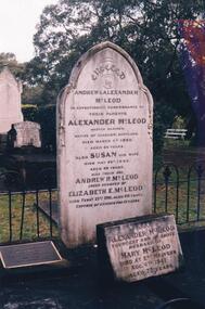
Photograph Album, Kodak, Phillip Island Cemetery, c 1889
The Album was compiled by Nancy McHaffie late 1990's, with the assistance of Edith Jeffery's, with her book "Garden of Memories" and extensive knowledge of Phillip Island. The Cemetery lies back from the road and is surrounded by Manna Gums, rare Peppermint Gums, Blackwoods and other native trees. In all 25 acres of land were set aside as Crown Land in the land settlement of 1868. There are 6.2 acres of wetlands near the cemetery entrance.Captain McLeod: Captain McLeod and family kept the Post Office at Newhaven. He also built a boat called old "Trusty" and launched it almost opposite Churchill Island. Unfortunately, at a later date, the "Trusty" was the cause of a tragedy. The bottom of the boat had become so encrusted with marine growth that the owner decided to beach her between the jetties at Griffiths point, now San Remo. Before the job was completed the soring gave way and allowed the boat to tip over on her side, causing Captain McLeod to be crushed to death. Died March 3rd 1880 aged 64 years. Also buried in this grave is his wife Susan - died May 24th 1882 aged 62 years. Their son Andrew McLeod died February 21st 1916 aged 60 - loved husband of Elizabeth E McLeod. Alexander was Captain of the "Genista" for 12 years.phillip island cemetery, captain alexander mcleod, susan mcleod, andrew mcleod, nancy mchaffie, edith jeffery -
 Ballarat Tramway Museum
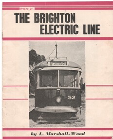
Book, Leon Marshall -Wood, "The Brighton Electric Line", 1956, 1958
.1 - Twenty page booklet on the history of the Brighton Electric Line by Leon Marshall-Wood, published 1956. Gives a brief history of the electric tramway operated by the Victorian Railways between St. Kilda Station and the Brighton Beach railway station, that commenced operation in 1905. The booklet was priced 2/-, published by the Traction Publications. Has 18 photographs, map 1905 and present day (when printed), rolling stock roster and notes and on the rear cover has details of the AETA. Front cover has horizontal crimson stripes. Has details of the AETA on the back cover and listing of some publications. Second copy from Ian Stanley added 24-1-2016. .2 - as for above - second edition, 1958, similar text, different photo layout and different front cover photo. See Reg Item 7631i for a scan of the 1966 edition.On front cover of first copy of .1 - top right hand corner; "N.Z.R.L.S / with compliments" and initials. Under title of book, "Price to Society 18/- Aust. per doz. / Retails 2/-" On page 3 of second copy of .1 - "Ian J Stanley 28 Park Road, South Camberwell, SE6, BK3746" On page 3 of .2 - "Ian J Stanley" in ink.trams, tramways, vr, melbourne, brighton, st kilda