Showing 32039 items
matching buildings
-
 Orbost & District Historical Society
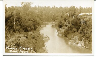
black / white photograph, late 19th - early 29th century
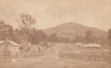
The building in this photograph of Boggy Creek is probably the first Nowa Nowa Hotel built by Moses Faithfull, in 1890. Moses Faithful came to Australia from England with his parents on the Royal Consort in 1844. After living at Bulla, Pakenham and Wurruk he and his wife moved to Hospital Creek in about 1885 where he took up the first selection of land at Upper Hospital Creek. As well as farming he built the first hotel at Nowa Nowa in 1890. He had charge of the hotel until 1895 when he sold to Mary Stirling. Moses died on 8th July 1901, aged 66, at the residence of his son-in-law, David Price, at Newmerella, and buried in the Orbost cemetery.This hotel was built in 1890 and doubled as a coaching stop on the inland route. Settlement grew up around the hotel. It was sold 1895 to Mary Stirling who husband own the land the hotel stood on. The hotel burned down on 29 July 1955. This is a pictorial record of Nowa Nowa in the late 19th century.A black / white photograph / postcard of a creek with a building on the rightside. a windmillis to the left. The banks of the creek are well-vegetated.on front - bottom left -"BOGGY CREEK NOWA NOWA"boggy-creek-nowa-nowa -
 Glenelg Shire Council Cultural Collection
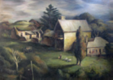
Painting - Oil Painting, Kenneth Jack, Captain Blair's House, n.d
Image showing three stone buildings in a country scene. In the foreground there is man and child and two goats. There is a car with three people surrounding it. The weather looks dark, dark clouds. A large Norfolk Pine behind the building. The middle building is two storey with an outhouse attached. A chimney and two spires at each end of the house. The building to the right of the main building is weatherboard with a fence. To the left of the main building is a ruined stone building with the roof fallen in. Trees and hills surround. Gold painted frame.Bottom right - Kenneth Jack - July 1952 -
 Port Melbourne Historical & Preservation Society
Photograph - Relocated and damaged cornerstone, Missions to Seamen, Port Melbourne, Bob Gooding, Jul 2015
During demolition of the 1937 Missions to Seamen building in October 1995, this stone was removed intact by developers Mirvac Victoria, and placed in the care of the PMH&PS.Photograph taken by member Bob Gooding showing severe damage to the stone on July 2015 Cornerstone laid at the Missions to Seamen building, Beach Road and Swallow Street, in 1937. Now located in the seawall surrounding the carpark at the foot of Nott Stmissions to seamen, harry a norris, lord huntingfield -
 Bacchus Marsh & District Historical Society
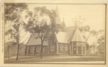
Photograph, Holy Trinity Church Bacchus Marsh 1883
The Holy Trinity Anglican Church in this location was first opened in 1877. An earlier nearby prefabricated Church building known as the 'Iron Church' had served as the Anglican place of worship in Bacchus Marsh from around 1855 until 1877. The 1877 sandstone Church with a slate roof was intended as a permanent structure for Anglican worship in Bacchus Marsh and still stands in 2024 and continues to function as an Anglican Church. The building was designed by Frederick Wyatt and is described as early English Gothic in style. It was opened on 5 June 1877 by Bishop Moorhouse of Melbourne. The sandstone was acquired from Grant's quarry at Maddingley.Small sepia unframed photograph on card with gold border framing photograph. Housed in the Jeremeas Family Album, which contains photographs of Bacchus Marsh and District in 1883 by Stevenson and McNicoll. The photograph depicts the recently constructed Anglican Holy Trinity Church in Gisborne Road, Bacchus Marsh. The view of the building is from Gisborne Road looking west. From this angle the rear and southern side of the building can be seen. A picket fence along the entrance to the Church grounds can be seen in the foreground.On the front: Stevenson & McNicoll. Photo. 108 Elizabeth St. Melbourne. COPIES CAN BE OBTAINED AT ANY TIME. On the back: LIGHT & TRUTH inscribed on a banner surmounted by a representation of the rising sun. Copies of this Portrait can be had at any time by sending the Name and Post Office Money Order or Stamps for the amount of order to STEVENSON & McNICOLL LATE BENSON & STEVENSON, Photographers. 108 Elizabeth Street, MELBOURNE churches bacchus marsh, holy trinity anglican church bacchus marsh, holy trinity church of england bacchus marsh, stevenson and mcnicoll 1883 photographs of bacchus marsh and district -
 Eltham District Historical Society Inc
Photograph, View looking up 'Policeman's Hill' on Main Road from Dalton Street showing Police Residence, c.1906, 2010c
For original image see EDHS_00533 This photo was originally mounted on 3mm MDF fibre board with notes and stickers applied as part of a display on the former Police Residence and now present day Local History Centre, home to Eltham District Historical Society; possibly put together by Harry Gilham during his time as president of the society. Eltham Police Station and Residence: A brief history 1860 Eltham Courthouse built in Main Road, together with an adjoining police residence, office, lock–up and stables. 1959 Police Department purchases a house in Pryor Street to be refurbished as Eltham Police Station 1961 Police in Eltham move into Pryor Street refurbished buildings and office. c.1961-1981 Occupied by Vermin and Noxious Weeds Destruction Section of the Department of Crown Lands and Survey. Former Police Station dragged around to rear of Police Residence (prior to August 1967) to make way for the construction of a driveway and access from Main Road. The building was placed on the site of a former Scullery and modified for Lands Department use. 1981 Shire of Eltham take over management of old Police Residence in Eltham. It remains unoccupied for a period of time whilst its future is discussed in Council. 1981-1985 Used for community job creation scheme 1985 Shire of Eltham Parks and Environment occupy the residence. Council improve the driveway but later add a second rear access from Brougham Street due to the dangerous nature of the Main Road entrance. Also add a rear toilet facility between the Police Residence and former Police Station, which was doubling up as a lunch room. Council also commence discussions to re-establish a replica Police Station. c.1986 November. Former Police Station demolished; believed to have been suffering termite damage. c.1989 After some years of discussion a replica Police Station is built, based on photographs, to act as a lunch room and meeting room for Parks and Environment staff and volunteers doing community service. 1996 Eltham District Historical Society in discussions with Nillumbik Shire Council commisioners throughout the year regarding a home for the Society. A proposal put forward by the Society in October to occupy the former Police Residence. 1997 March. Eltham District Historical Society gains access to former Police Residence. 1998 July 12th. Eltham District Historical Society Inc moves into its Local History Centre, 728 Main Road Eltham (the former Police Residnce built in 1860). 2018 July. Eltham District Historical Society gains access to the replica Police Station for use as part of regular heritage tours for schools and community based groups.Black and white photocopyLabels and handwriting in pencil and ink identifying various buildings. Also highlighted is the acetylene gas lamp and on reverse is written "Lamplighter Jimm Saville"728 main road, eltham, local history centre, parks and environment, police residence, police station, shire of eltham -
 Sunbury Family History and Heritage Society Inc.
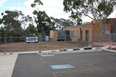
Photograph, Rosa McCall, 2nd January 2018
The former Sunbury Library was demolished and the empty site is ready for the construction of the new library. The existing building housed the George Evans Museum. A more modern Global Learning Centre is planned to be built on the site.A coloured photograph of a fenced site with a flat-roofed cream brick building adjacent to an area that has a been cleared in preparation for construction. A demolition sign is attached to the wire fence. Gum trees are growing in three background.libraries, global learning centre, sunbury, hume city council, macedon street, sunbury library -
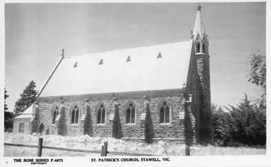 Stawell Historical Society Inc
Photograph, St. Patrick’s Catholic Church 1920 -- Postcard
Rose series postcard c1920 of St. Patrick’s Catholic Church Side view of church with wooden sanctuary at back of building. Later the sanctuary was built onto this side of the Church in 1927.Post card of St Patrick's Church Stawell and a photographic enlargement. Both photos are black & white, showing a side view of the church with a wooden sanctuary at the back of the building. Pine trees can be seen front and back of the church.The rose series P. 4873 St Patrick's Church Stawell, Vic. on the back POST Card A Real Photograph Produced in Australiastawell -
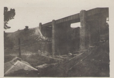 Sunbury Family History and Heritage Society Inc.
Photograph, Rupertswood Viaduct
The stone bridge is one of the many bridges built along the Bendigo Rail Line. This one along with four others ar in Sunbury which were built in the late 1850s. his bridge spans the Ruoertswood Viaduct which is north of the Sunbury Station. The building in the LH corner was a pump house where water was pumped and taken to the water tower on Sunbury Station where the steam trains stopped to replenish the water tanks. The Bendigo Rail Line was the first Government owned and operated to be constructed in Victoria. Along the railway a number of famous bridges and tunnels were built and are of historical significance. The bridge spanning the Rupertswood Viaduct is one of them. A black and white photograph with a cream border of a high bridge spanning a deep valley. The roof of a small building is visible in the bottom LHS corner of the photograph.bridges, railways, rupertswood viaduct -
 Kew Historical Society Inc
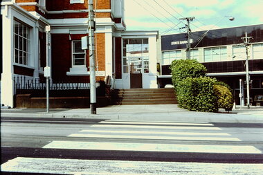
Slide - Kew Post Office, 1980
A civic campaign for new public offices developed in Kew in the 1880s. After much deliberation, the location chosen was the junction of Bulleen and Cotham Roads. The buildings were designed by George Watson and John Henry Harvey, architects within the Department of Public Works (Victoria). Building was commenced in 1887, and after one year, the buildings were opened. The Post Office was transferred to the new Commonwealth Government in 1901. The Police Station and Court House, sold by the Victorian Government to the City of Boroondara in 2007, are now a community cultural centre and performing arts venue.The buildings were listed on the Victorian Heritage Register Register (HO885) in 1991. They are historically and architecturally significant to the State of Victoria because Watson and Harvey's designs exhibit diversity in integrating civil offices, they accommodate the apex of road junctions, and they demonstrate a departure from the contemporaneously favoured High Victorian Classical to the Queen Anne style in the design of civic buildings. 35mm colour transparency of the front of the Kew Post Office showing the State Bank on the other side of Cotham Road. The Post office is a significant example of the English Queen Anne Revival style. The photograph was taken as part of a series by Ralph Andrews (Department of Building, RMIT) in April 1980.kew post office, khs - slides, new public offices -- kew (vic.), architectural styles -- english queen anne revival -
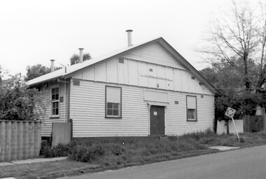
Streatham and District Historical Society
Picture, Streatham Hall
... buildings ...Shows the structure and building mateials of the time. Demonstrats the need for social acivities and the need for a venue for that to happen.Demonstrates the buildings that were lost during the 1977 fires the burnt most of Streatham down.A square Black & white photo of the Streatham Hall taken from the front incluing a side angle as well. Itis a single story weatherboard structure with two doors and four windows in view.In green ink stamped on back "317"weatherboard, buildings, hall, community, streatham, structures, social, activities -
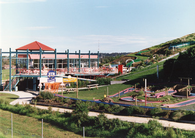 Lakes Entrance Historical Society
Photograph - Kinkuna, 2009
Kinkuna Amusement Park was opened 19 December 1987, closed 2002, building demolished or removed, land sold and subdivided into residential allotments.Copy colour photographic print showing Kinkuna Amusement Park on Princes Highway, owned by Joe and Shirley Walters. Photo shows main building and restaurant, mini golf, long taboggan on hill, garden and other attractions. Lakes Entrance Victoriaentertainment, recreation -
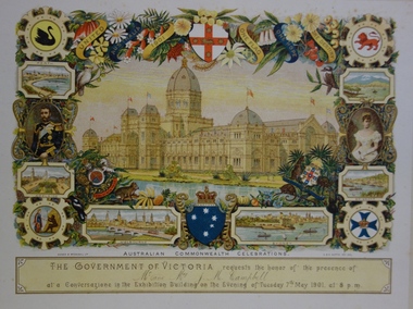 Kew Historical Society Inc
Document - Invitation to a ‘Conversazione’ in the Exhibition Building, George Austin, 1901
A report in the Ballarat Star on 8 May 1901 recorded that: "THE CONVERSAZIONE. A GREAT SUCCESS. The conversazion given by the Government of Victoria at the Exhibition was very largely patronised. the guests includ ing the Prime Minister and a goodly proportion of the distinguished personages now in Melbourne. A programme of high-class music was gone through, and refreshments were served during the evening. Australian wines were very prominent."The document design has artistic and aesthetic merit. While it is not rare, it is representative of the kinds of formal designs used for the Australian Commonwealth celebrations at the time of Federation, and is in excellent condition. Such items as this invitation have local, state and national historic significance as mementoes of a key moment in Australia's history. Locally, the invitation is part of a group of Federation-related items issued to James Maitland Campbell (and his wife). Campbell was three times mayor of Kew in the second half of the 19th Century and the owner of Ramornie in Pakington Street, one of the significant extant mansions in Kew.Colour lithograph mounted on card to an evening event, a conversazione, held in the Exhibition Building on the evening of Tuesday 7th May 1901, as part of the Australian Commonwealth Celebrations. The recipients of the invitation were Mr and Mrs James Maitland Campbell of Kew. The Government of Victoria hosted the event. The invitation shows an etching of the Exhibition Building, surrounded by an ornate border of heraldic shields, portraits of the Duke and Duchess, views of Perth, Adelaide, Melbourne, Sydney, Brisbane and Hobart, and native flora (including wattle, waratah, pink heath, Sturt’s desert pea, and flannel flower), and native fauna (kookaburra, possum, lyre bird, cockatoo and koala). The royal crest ‘Dieu et mon droit’ and the Australian crest, ‘Advance Australia’ are also included.Printed: UNITED AUSTRALIA 1901 / ONE FLAG / ONE HOPE / ONE DESTINY; AUSTRALIAN COMMONWEALTH CELEBRATIONS / THE GOVERNMENT OF VICTORIA requests the honour of the presence of / / at a Conversazione in the Exhibition Building on the Evening of Tuesday 7th May 1901 at 8 P.M. Handwritten: Mr & Mrs J. M. Campbell.sands & mcdougall ltd, documents - invitations, first commonwealth parliament 1901, james maitland campbell (1847-1930), ramornie, ramornie - pakington street -
 Mt Dandenong & District Historical Society Inc.
Photograph, View of the Kalorama Valley c1905
John Lundy-Clarke grew up in the Kalorama/Mt Dandenong area and later in life (1972-74) began to write a comprehensive history of the area working from an original settlement map in an effort to cover all areas. This photograph c1905 is looking up from George Barber's house 'Forest Edge' on Barbers Road. 'Forest Edge' was built c1898 and was the home of George Barber and his wife Sarah Ann (nee Richardson). The buildings in the foreground are the stables and hayshed.Black and white photograph showing two small buildings in the foreground with cleared hills behind. Handwritten decription on back by John Lundy-ClarkeA 1905 view of the Kalorama Valley towards the Gap. Barbers stables in foreground with hayshed on left. Tait’s house in centre of picture with Logans in the same fold above the hayshed. “Kalorama” is centre of Gap with Paynter’s “Iona” on its left with stables to its left. It was from one of these trees on the top left that the runaway log was cut that leaped over Barbers Road (at the top edge of the cleared land) then over Logan’s house in one bound in 1930.george barber, sarah ann barber, john lundy-clarke, forest edge -
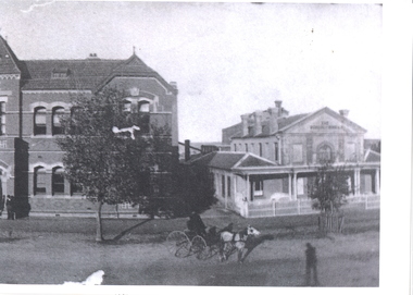
 Orbost & District Historical Society
black and white photograph, C1900
The 19th of March 1886 proved an important day in the lives of many early settlers in the Orbost area, because on this day the Orbost State School opened. The fact that the school had first operated temporarily in a leased building, and on a half-time basis with SS2745 Jarrahmond, did not dampen the enthusiasm of the local inhabitants as they saw their offspring commence their education under the guidance of HT Campbell Mackay. However he remained in charge only until 12th of May 1886. The second HT, John Rowe, served until 1908. On 30th of June 1887, a portable room was provided; it being brought to the area by schooner. The school now had accommodation for 30 pupils; the teacher's welfare was considered because quarters of two rooms were attached. As the population increased so did the needs of the school. This was reflected in the provision of a larger classroom in 1898. During 1910-11 the first approaches were made to the Department for the establishment of a HES in Orbost and this became a reality in 1912. Orbost HES supplied post-primary education in the district until a high school was built in 1948. When fire destroyed the school in 1941 local halls were used as classrooms until a new school was built. Work was quite rapid and a new brick structure was opened by the Hon. A. E. Lind, MLA, on 13th of February 1942. This new building was a fine type of school of which both the pupils and the HT Leslie Collins were indeed proud. But Orbost continued to develop and the new school was soon overtaxed. This resulted in the erection of two Bristol classrooms in 1947. By 1950, when the school population had reached 500 pupils the opening of the new school at Orbost North was welcomed by all concerned. In 1963 the Department purchased land diagonally opposite the school and developed it as a playing area. In 1965 two LTCs were opened in November, and in October 1968 the Brodribb School building was moved to SS2744 Orbost for use as a general purpose room. ( info. Schools East Gippsland) This item is associated with the history of education in Orbost.A black / white photograph framed by a grey buff card. It shows grade three students standing in front of a wooden school building.education-orbost orbost-state-school -
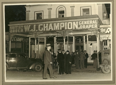 Clunes Museum
Photograph, RIALTO, BALLARAT (ORIGINAL)
... buildings ...W.J. CHAMPION OWNED A GENERAL DRAPER SHOP IN FRASER STREET, CLUNES FOR MANY YEARS. TWO STOREY BUILDING, THREE SHOP WINDOWS, IRON VERANDAH POSTS, ORNATE CAST IRON DECORATION ON TOP OF POSTS..1 SEPIA PHOTOGRAPH MOUNTED ON CARDBOARD OF W. J. CHAMPION SHOP, FRASER STREET, CLUNES, GROUP OF GENTLEMEN IN FOREGROUND. .2 BLACK AND WHITE COPY OF THE ABOVE PHOTOGRAPH PRINTED ON GLOSS PHOTOGRAPHIC PAPERlocal history, photography, photographs, shops, w.j. champion.[ 2 storey building], buildings -
 Federation University Historical Collection
Photograph - Photograph - Black and White, School of Mines Ballarat; c1910, c1910
The former Ballarat Circuit Courthouse was used as the first site of the Ballarat School of Mines in 1870.Black and white photograph of two buildings at the Ballarat School of Mines. The one on the right is the former Ballarat Circuit Court House which was demolished to make way for the Ballarat Technical Art School (Gribble Building). The building on the left was orginally known as the New Classrooms and were opened in 1901. It is now known as the Administration Building (A-Building).ballarat school of mines, administration building, new classrooms, ballarat circuit court house, lydiard street south -
 Bendigo Historical Society Inc.
Slide - BENDIGO VIEWS, May 1961
Slide. Bendigo Views. Two story grey building with white window frames, a smaller cream brick building to the left and another three story building on the right. This building has scaffolding around it. Two tradesman's vehicles are in front of the buildings. Trees on the right of the picture. In the foreground is grass and weeds. The first Mt Alvernia Hospital.slide, bendigo, bendigo views, bendigo views -
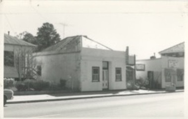
 Charlton Golden Grains Museum Inc
Photograph, Bourke's Butcher Shop High St Charlton c. 1987, c.1987
Corner of High St and Williams St (now Curtin Dve). Formerly the site of Wingfield's Hides and Wool agent and Frank O'Grady's solicitors office. In 1971 Jim Bannon moved his butcher business from the eastern end of High St to this newly built shop. He sold to Weirs in 1986 who sold to Frank Bourke in 1987. Part of a streetscape series taken for the Shire of Charlton in 1987. Bourke's butchers shop built 1971 for J Bannon. Shows area now occupied by the Travellers Rest complex.Colour photograph of single storey brick building with large glass window and door. Tree in front of building and a man walking past. Two storey white building to the right and a street and old single storey building on the left. Car parked in street on the LH side of the photo. Signage on the old building on the left reads STATES. jim bannon, frank bourke, wingfield's hides, frank o'grady, business, industry, charlton, butcher -
 Surrey Hills Historical Society Collection
Photograph, W J Vine, timber merchant and ironmonger, c1899
Vines Timber yard was established in 1897 after the timber yard established by Donald Douglas in 1887 was acquired by William James Vine in 1896. Vines Timber yard was managed by William and his son Albert Ernest (Ernie) until the 1950s when there were no vacant blocks of land in Surrey Hills and less requirement for building materials. William Vine is listed in the 1893 directory as living in Albany Crescent. He married Sarah Elizabeth Gunner in 1881. The business was badly affected by a large fire in 1920. Albert Vine (1903-1968) was a Camberwell councillor from 1926-1934. He was also Mayor of Camberwell in 1940/41 and a councillor from 1937-1944. His son Ernest Albert also becoming a Councillor and Mayor of Camberwell. Exterior of building of W J Vine timber merchant and ironmonger in 1899. There are 5 men standing outside. 'Year 1899' in lower LH cornerbusinesses, timber merchant, ironmonger, vine's timber yard, donald douglas, william james vine, ernie vine, albert ernest vine, sarah elizabeth gunner, sarah elizabeth vine -
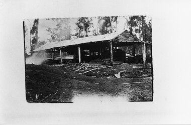 Halls Gap & Grampians Historical Society
Photograph - B/W, C 1910
Unknown timber mill in the Grampians.The photo shows an open sided building. In the building there is cut wood stacked on a trolley to the left with further, further cut wood in front of it. A steam engine can be seen in the far side of the building. Off-cuts and saw dust are visible in front of the building.timber industries, logging, sawmilling -
 Kilmore Historical Society
Photograph, 19 Sydney Street
14cm x 9cm black and white photograph of 19 Sydney Street. Small, light coloured, rendered, single story building between and private resident and another commercial building. There is a sign on the building advertising Kilmore Garden Nursery inside the building. Written on the back: 19 Sydney 601shopfronts, nurseries, retail stores -
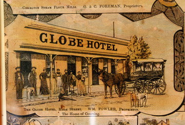 Charlton Golden Grains Museum Inc
Photograph - Lithograph, Rider & Mercer, Views of Charlton, c.1988
The Globe Hotel built 1874-75 for John Walsh was destroyed by fire and rebuilt in ?. Leased by William Fowler in 1891 who had been in Charlton since 1877. Copy of Lithograph of Charlton buildings. Large sign on building 'GLOBE HOTEL'. Eight men and women and three children standing in front of building, a horse and wagon also in front of the building with a man standing in the wagon holding the reins. Two greyhounds on the road.The Globe Hotel, High Street. WM. Fowler, Proprietor. The Home of Coursing.lithograph, globe hotel, fowler william, walsh john -
 Surrey Hills Historical Society Collection
Photograph, Scout Hall at 7 Robinson Road, Surrey Hills in 1990
The Box Hill Reporter noted on 22 January 1926 that at the monthly meeting of the Surrey Hills Progress Association the Secretary reported that “the ground had been purchased for the Boy Scout Hall, that plans had been prepared, and accepted by the building committee. As soon as the timber was available the work would be proceeded with. The Boy Scout Hall movement has been taken up by the association to try to secure a permanent meeting place for the boys of the district. Up till now they have no fixed place, nor have they had a qualified scout master. Mr. Bert Chenu, one of the committee, has been appointed to that position, and is carrying out his duties energetically. Having raised enough money to purchase the land (situated in Robinson's road, Surrey-Hills near the Drill Hall) the association's committee is now about to erect the building by means of properly organised working bees.” The Association organised markets, card evenings and dances to raise necessary funds. The volunteer labour included the parents of boys who had become scouts, led by builder Robert Hayes of 186 Union Road and his son, who was also a builder. Early ownership is unclear as it is believed that it was not purchased by the scouting movement until 1955. The hall was used by other groups as well as the scouts. Benmont Kindergarten operated on the site from c1930. This is confirmed by oral testimony, Sands & McDougall entries and the Alan Hold property register (part of the SHNC Heritage Collection.) It was also used as a ballet school and for local dances. The hall was situated on a small block of land, just 410 sq m, and in late 2019 it was put up for sale by Scouts Victoria. Most recently home to 1st Boroondara Scout Group and previously 11th Camberwell Scouts, it was sold for something near $1.3M. During May 2020 the modest hall was demolished. Items of significance were removed before the sale by Scout Heritage. A black and white photograph of a building with a small sign identifying it as 11th Camberwell Central Scout Group.robinson road, surrey hills, scout halls, scouts, buildings, structures and establishments, (mr) robert hayes, union road, builders, surrey hills progress association, benmont kindergarten, dances, ballet schools -
 Old Gippstown
Building - School
2903 SUNNY CREEK formerly YARRAGON EAST. Sunny Creek State School, first called Yarragon East, was situated on Sunny Creek Road between Yarragon and Trafalgar and was opened in 1888. It was generally served by two teachers or a Head Teacher assisted by a Sewing Mistress. Edwin Mann taught there for 35 years, with his wife, Mrs Mann, as the Sewing Mistress for some years. [Extracted from Vision and Realisation: A Centenary History of State Education in Victoria, Vol. 3, 1973. This does not contain any details of the actual construction of the school, which is a typical Education Department building, and may date from later than 1888]High local historic significance, with some social significance: reunions of old students still held. (Dr Linda Young, Deakin University, significance assessment July 2009)Single-classroom State School. It is a rectangular-shaped timber building with weatherboard walls, timber frame and corrugated iron roof. An outside verandah is situated along the side of the building. Inside there is a small entry porch, a blackboard the length of the room (with fireplace) and a small store-room/cloak room. Built in 1888Has a name board above the front window that reads " SUNNY CREEK SCHOOL SS2903".school, sunny creek, old gippstown, west gippsland, gippsland, gippsland heritage park, goldfields, coal mines, victorian era, moe, historical village, education, sunny creek road, baw baw shire, yarragon east, latrobe valley, old gippsland heritage park, latrobe city council, board of education -
 Federation University Historical Collection
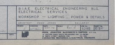
Plan, Ballarat School of Mines M.B. John Workshop Building, c1979
... buildings ...Ewan Jones and Associates were the architect of this building on the SMB Campus. Two plans for new workshops along Albert Street. Later to be refurbished for Ballarat Tech. The first level was designed for Fitting and Machining. The second level for Art, Ceramics, painting and decorating.m.b. john building, workshops, trades, ceramics, ballarat tech, buildings, ewan jones and associates, smb campus, ballarat school of mines -
 Phillip Island and District Historical Society Inc.
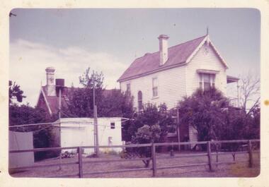
Photograph, Anderson Family Homestead, 1960
... buildings ...Side aspect of Glen Isla from street, wooden rail fence, double story section of building on right. To left single story building.Side view of Glen Isla Homesteadlocal history, photography, photographs, slides, film, buildings, historic, glen isla homestead, phillip island, coloured photograph, mrs emma anderson jacobs -
 The Beechworth Burke Museum
Photograph - Carte de Visite
In July of 1880, Ann Jones' successful hotel in Glenrowan burnt to the ground during the Kelly siege. She had opened her business in the year prior having been unsuccessful in her attempt to run a tea-room business in Wangaratta. The first building on this particular site was the home Ann Jones had built for herself and her family. Two years later she converted the home and added the hotel to the rear of the structure. One year later it was burnt to the ground. This image depicts the streetscape of Glenrowan in 1883, three years after the siege. Importantly, it reveals the appearance of several buildings which can reveal information for how Glenrowan (as a small town) might have stood during the siege. These buildings are of typical Australian colonial "miner's cottage" style. On what would have been the site of Ann Jones' hotel, to the far left of the photograph, a police station stands. This police station was built before April 1883. This image was captured by an unknown photographer. This Carte-de-viste (CdV) previously belonged to the donor's grandfather, Daniel Mullins who was a Police Officer stationed at Glenrowan soon after the Kelly gang siege. Today, the siege has become an important part of Australian culture and Ned Kelly and the Kelly Gang (comprising of Ned Kelly, Dan Kelly, Steve Hart and Joe Byrne) has become ingrained in Australian history and mythology. A CdV is a sepia toned photograph mounted on card and is generally of a small size. This particular style was first patented by Andre Adolphe Eugene Disdéri (1819-1889) in 1854. In 1857, the CdV was introduced to England and after photographs of Queen Victoria, Prince Albert and their family were taken using CdV in 1860 the popularity of this method reached a peak.This photograph is part of the Burke Museum "Kelly album" which includes a significant collection of photographs and artefacts connected to Ned Kelly and the Kelly Gang. Ned Kelly and his gang have become ingrained in Australian popular culture and thus many museums, art galleries and private collections house material connected to the Kelly story which allows the events and people to be researched and interpreted. Artefacts and photographs pertaining to the Kelly gang are particularly valuable for Australian museums. This particular photograph is significant for its connection to the Glenrowan Siege and Ann Jones' Hotel which burnt down during the siege in June 1880. Taken in 1883, this photograph (taken by an unidentified photographer) has the opportunity to provide information about the townscape of Glenrowan shortly after the siege. It also provides important insight into the architecture and layout of the town. To the far right of the image, the photograph depicts the police station which was built on the site of Ann Jones' Hotel which can provide important information for the Kelly story and how the town evolved following 1880. It is also interesting to emphasise that the police station was built on the site of Ned Kelly and the Kelly gang's last stand.This photograph is a sepia image of the Glenrowan streetscape depicting several buildings. The newly built police station (in 1883) stands on the far right of the image on the site of the former Ann Jones Hotel. On the left are several buildings built in typical 'miner's cottage' Australian colonial style. This includes the gable roof with the skillion at rear. An unidentifiable individual stands next to the chimney of the front left building. Numerous paddocks appear in the image, particularly in the front right and the rear of the houses contain many trees. To the rear of the image, there is a mountain. A street runs through the centre of the photograph.Glenrowan / taken 1.4.83 ... / BMM 8086kelly album, ned kelly, glenrowan, police history, police, australian architecture, streetscape, glenrowan 1883, 1883, dan kelly, steve hart, joe byrne, carte-de-viste, james bray, daniel mullins, william e barnes, colonial australia, police station, photograph -
 Kew Historical Society Inc
Document, Sands & McDougall Ltd, Invitation to a ‘Conversazione’ in the Exhibition Building, 1901
A report in the Ballarat Star on 8 May 1901 recorded that: "THE CONVERSAZIONE. A GREAT SUCCESS. The conversazion given by the Government of Victoria at the Exhibition was very largely patronised. the guests includ ing the Prime Minister and a goodly proportion of the distinguished personages now in Melbourne. A programme of high-class music was gone through, and refreshments were served during the evening. Australian wines were very prominent."The document design has artistic and aesthetic merit. While it is not rare, it is representative of the kinds of formal designs used for the Australian Commonwealth celebrations at the time of Federation, and is in excellent condition. Such items as this invitation have local, state and national historic significance as mementoes of a key moment in Australia's history. Locally, the invitation is part of a group of Federation-related items owned and displayed by Mrs Grace Tabulo, the owner of 'Fairyland', 57 Malmsbury Street, Kew.Colour lithograph mounted on card to an evening event, a conversazione, held in the Exhibition Building on the evening of Tuesday 7th May 1901, as part of the Australian Commonwealth Celebrations. The Government of Victoria hosted the event. The invitation shows an etching of the Exhibition Building, surrounded by an ornate border of heraldic shields, portraits of the Duke and Duchess, views of Perth, Adelaide, Melbourne, Sydney, Brisbane and Hobart, and native flora (including wattle, waratah, pink heath, Sturt’s desert pea, and flannel flower), and native fauna (kookaburra, possum, lyre bird, cockatoo and koala). The royal crest ‘Dieu et mon droit’ and the Australian crest, ‘Advance Australia’ are also included.Printed front: UNITED AUSTRALIA 1901 / ONE FLAG / ONE HOPE / ONE DESTINY; AUSTRALIAN COMMONWEALTH CELEBRATIONS / THE GOVERNMENT OF VICTORIA requests the honour of the presence of / [name deleted] / at a Conversazione in the Exhibition Building on the Evening of Tuesday 7th May 1901 at 8 P.M. Reverse [handwritten]: Mrs G. Tabulo, 57 Malmsbury St.sands & mcdougall ltd, documents - invitations, first commonwealth parliament 1901, grace tabulo -- fairyland -- 57 malmsbury street -- kew (vic.) -
 Falls Creek Historical Society
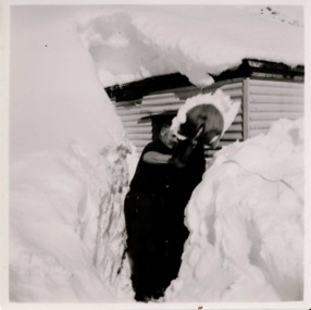
Photograph - Bogong 12 July 1953
This photo is part of the Fred Griffith Photographic Collection documenting his time with the Australian Alpine Club and the formation of the Albury Ski Club. Frederick Charles “Fred” Griffith was born in Albury, NSW on 2 March 1910. Educated in Albury and Geelong Grammar. Beginning in 1927 he spent many years working first as a jackeroo and on a range of prominent pastoral and merino stud properties in NSW and Queensland. In 1935 he repurchased his former family property “Toonallook", Bowna, NSW and developed it to be the largest Romney Marsh stud in the world, exporting rams to Argentina. He introduced many innovative practices on his property including rabbit control measures and aerial crop dusting. He was an active member of the Albury Show Society and in 1949 established the Albury Sheep Show. Fred was also the Albury representative on the Graziers’ Association Council for over 30 years. He became a life member of both the Albury and Commercial Clubs. Fred’s greatest hobby was snow skiing. His first visit to the snow was to Kosciusko in 1919. The Albury Ski Club was formed in 1935 and Fred was an inaugural member. In 1949 they were granted a site at Falls Creek to build their own lodge. Fred guaranteed the Club for finance from the Bank of NSW. The first portion of the prefabricated building was constructed in Albury. It was transported to Falls Creek on the back of Fred’s truck and erected in one day. This was the bathroom section and the rest was completed in 1950. The original lodge was burned down in 1952 and a new one built the following year. In 1955, Fred also built the Bowna Lodge for his family in partnership with David Fairbairn. He became head of the North Eastern District Skiing Association (N.E.D.S.A.) and successfully applied to run the Australian Ski Championships. Fred also inaugurated children’s races at Falls Creek and ran them for about 20 years. He also formed the company “Falls Creek Ski Tows”. In 1956 Fred along with a group of key people selected the site for Thredbo Village. Fred and his brother sold Toonallook in sections between 1951 and 1974. He moved to Albury and set up as a landscape gardener and fencing contractor. After a serious work accident, Fred retired in 1985 and moved to Rosebud, Victoria where he died on 19 August 1992. This image is from the Fred Griffith collection which documents the early development of Falls Creek.Black and white square photograph of man shovelling snow in front of himself. There are high levels of snow either side of man and building in the background. Snow is on top of building. Stamped - SUPER / G & D . SERVICE Pencil - 61bogong, falls creek, snow, snowfields -
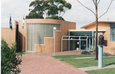 Sunbury Family History and Heritage Society Inc.
Photograph, c1985
The photograph shows the extensions that were built on to the former Shire of Bulla offices in the mid 1980s. The building with the curved wall and glass tiles was where the Shire of Bulla held their council meetings. The Victorian state flag and the Shire of Bulla flags are hoisted on the poles and the bust of George Evans, an early European settler in the district is on the RHS of the image. The extensions completed in the 1980s to the former Shire of Bulla offices were the last major works to be undertaken on the building before Bulla Shire became part of Hume City Council in 1994.A coloured photograph of a brick paved path leading to a cream brick community building with two flags hoisted on flagpoles near the entrance . The bust of a man is visible on the RHS of the image. shire of bulla, council offices, shire of bulla council offices., george evans