Showing 3205 items
matching 1948
-
 Kew Historical Society Inc
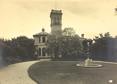
Photograph - 84 Princess Street (Kew), c. 1935
An item forming part of a collection of costumes, photographs and documents relating to the Weir family who lived in a mansion, originally named Illapa, at 84 Princess Street, Kew, from c.1917 to 1950. This historically significant collection includes items relating to both George Weir (1866-1937), his wife Edith Mary Weir (1867-1948) and their children. George Weir attained national prominence in the mining industry, becoming General Manager of the North Broken Hill Silver Mining Company in 1903 (later renamed North Broken Hill Mining Company 1905-12, and North Broken Hill Ltd 1912-1988), and subsequently President of the Mine Owners Association. He was to remain General Manager of North Broken Hill Ltd until his retirement in 1926.Sepia-toned photograph of 84 Princess Street, Kew during the occupation of the house by the Weir family during the years 1918-1950. The house and garden had formerly been named Illapa and then Parcnacilla. In 1950 the family sold the house to a religious order who renamed the house 'The Towers'. It now forms part of 'Rylands'.illapa -- 84 princess street -- kew (vic.), george weir, edith mary weir (nee betteridge), weir collection -
 Kew Historical Society Inc
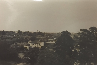
Photograph - Studley Park (Kew), c.1949
An item forming part of a collection of costumes, photographs and documents relating to the Weir family who lived in a mansion, originally named Illapa, at 84 Princess Street, Kew, from c.1917 to 1950. This historically significant collection includes items relating to both George Weir (1866-1937), his wife Edith Mary Weir (1867-1948) and their children. George Weir attained national prominence in the mining industry, becoming General Manager of the North Broken Hill Silver Mining Company in 1903 (later renamed North Broken Hill Mining Company 1905-12, and North Broken Hill Ltd 1912-1988), and subsequently President of the Mine Owners Association. He was to remain General Manager of North Broken Hill Ltd until his retirement in 1926.Small black and white photograph of a panoramic view from the tower of 84 Princess Street, Kew during the occupation of the house by the Weir family during the years 1918-1950. The house and garden had formerly been named Illapa and then Parcnacilla. In 1950 the family sold the house to a religious order who renamed the house 'The Towers'. It now forms part of 'Rylands'.illapa -- 84 princess street -- kew (vic.), aerial photographs -- kew (vic.), studley park (kew) -1930s -
 Kew Historical Society Inc
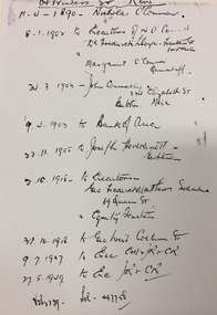
Document - Manuscript [copy], List of Owners, 84 Princess Street (Kew), 1890-1949, c.1949
An item forming part of a collection of costumes, photographs and documents relating to the Weir family who lived in a mansion, originally named Illapa, at 84 Princess Street, Kew, from c.1917 to 1950. This historically significant collection includes items relating to both George Weir (1866-1937), his wife Edith Mary Weir (1867-1948) and their children. George Weir attained national prominence in the mining industry, becoming General Manager of the North Broken Hill Silver Mining Company in 1903 (later renamed North Broken Hill Mining Company 1905-12, and North Broken Hill Ltd 1912-1988), and subsequently President of the Mine Owners Association. He was to remain General Manager of North Broken Hill Ltd until his retirement in 1926.Handwritten register of owners of 84 Princes Street, Kew. Built for John Hedderwick, the house was variously known throughout its history as Illapa and Parcnacilla. The list, compiled for the Weir family before they sold the house in 1950, includes the names of owners between 1890 and 1949.84 princess street -- kew (vic.), george weir -
 Kew Historical Society Inc
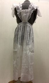
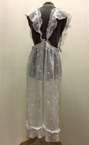
Clothing - Cream Voile Pinafore, c. 1898-1904
An item forming part of a collection of costumes, photographs and documents relating to the Weir family who lived in a mansion, originally named Illapa, at 84 Princess Street, Kew, from c.1917 to 1950. This historically significant collection includes items relating to both George Weir (1866-1937), his wife Edith Mary Weir (1867-1948) and their children. George Weir attained national prominence in the mining industry, becoming General Manager of the North Broken Hill Silver Mining Company in 1903 (later renamed North Broken Hill Mining Company 1905-12, and North Broken Hill Ltd 1912-1988), and subsequently President of the Mine Owners Association. He was to remain General Manager of North Broken Hill Ltd until his retirement in 1926.This garment is part of a collection of women’s clothing, owned and worn by Edith Mary Weir (nee Betteridge) - born in Clare, South Australia 1867, died Kew 1948 - and also by her daughter. The garments date from the 1880s to the 1930s. The collection includes day dresses, evening dresses, evening coats, capes, and undergarments. As the wife and daughter of a mine manager, the collection includes representative examples of clothing worn by upper middle class Australian women in domestic circumstances, and at social and civic events. A number of the costumes from the 1920s to the 1930s are of a particularly fine quality, being both rare, representative and intact examples of Australian fashion of the period. The garments in the Weir Collection were donated to the Kew Historical Society by a granddaughter of Edith Weir in 2017.Full-length decorative, spotted cream voile pinafore, designed to be worn over a full long dress. The pinafore has ruffled shoulder straps and a band of ruffle above the hem. This is one of two pinafores in the Weir Collection. This example, in contrast to the other pinafore, includes a small bodice.pinafores, women's clothing, edith mary weir, weir collection, aprons, protective wear -
 Kew Historical Society Inc
Clothing - Cream Voile Pinafore, c. 1898-1904
An item forming part of a collection of costumes, photographs and documents relating to the Weir family who lived in a mansion, originally named Illapa, at 84 Princess Street, Kew, from c.1917 to 1950. This historically significant collection includes items relating to both George Weir (1866-1937), his wife Edith Mary Weir (1867-1948) and their children. George Weir attained national prominence in the mining industry, becoming General Manager of the North Broken Hill Silver Mining Company in 1903 (later renamed North Broken Hill Mining Company 1905-12, and North Broken Hill Ltd 1912-1988), and subsequently President of the Mine Owners Association. He was to remain General Manager of North Broken Hill Ltd until his retirement in 1926.This garment is part of a collection of women’s clothing, owned and worn by Edith Mary Weir (nee Betteridge) - born in Clare, South Australia 1867, died Kew 1948 - and also by her daughter. The garments date from the 1880s to the 1930s. The collection includes day dresses, evening dresses, evening coats, capes, and undergarments. As the wife and daughter of a mine manager, the collection includes representative examples of clothing worn by upper middle class Australian women in domestic circumstances, and at social and civic events. A number of the costumes from the 1920s to the 1930s are of a particularly fine quality, being both rare, representative and intact examples of Australian fashion of the period. The garments in the Weir Collection were donated to the Kew Historical Society by a granddaughter of Edith Weir in 2017.Full-length decorative, spotted cream voile pinafore, designed to be worn over a full long dress. The pinafore has ruffled shoulder straps. This is one of two pinafores in the Weir Collection. This example, in contrast to the other pinafore, does not include a bodice.pinafores, weir collection, edith mary weir, women's clothing, aprons, protective wear -
 Kew Historical Society Inc
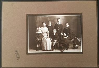
Photograph - The Weir family of Broken Hill, Sykes Studio, c.1914
An item forming part of a collection of costumes, photographs and documents relating to the Weir family who lived in the mansion originally named Illapa, 84 Princess Street, Kew, from c.1917 to 1950. This historically significant collection includes items relating to both George Weir (1866-1937) and his wife Edith Mary Weir (1867-1948). George Weir attained national prominence in the mining industry, becoming General Manager of the North Broken Hill Silver Mining Company in 1903 (later renamed North Broken Hill Mining Company 1905-12, and North Broken Hill Ltd 1912-1988), and subsequently President of the Mine Owners Association. He was to remain General Manager of North Broken Hill Ltd until his retirement in 1926.Important group family photograph, taken in Broken Hill, of Edith Mary Weir and her children. Another aspect of the photograph is that it is revealing about fashion and the tastes of the period.Studio portrait of Edith Mary Weir and her five children, taken by a photographer of the Sykes Studio in Broken Hill, New South Wales. The members of the family are from left to right: John Rigby Weir (1910-1971), Edith Mary Weir (nee Betteridge), Cecil Rigby Weir (1904-1983), Horace Rigby Weir (1907-1988), George Rigby Weir (1901-1927), and Edith Rigby Weir (1899-1981). [John Rigby Weir was the donor's father].Stykes Studio / Broken Hillweir collection, george weir, horace rigby weir, george rigby weir, john rigby weir, edith rigby weir, edith mary weir (nee betteridge), sykes studio -- broken hill -
 Kew Historical Society Inc
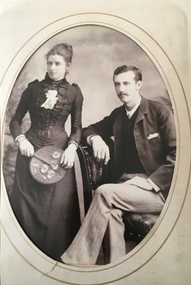
Photograph - George and Edith Weir, Yeomans Studio, 1891
An item forming part of a collection of costumes, photographs and documents relating to the Weir family who lived in the mansion originally named Illapa, 84 Princess Street, Kew, from c.1917 to 1950. This historically significant collection includes items relating to both George Weir (1866-1937) and his wife Edith Mary Weir (1867-1948). George Weir attained national prominence in the mining industry, becoming General Manager of the North Broken Hill Silver Mining Company in 1903 (later renamed North Broken Hill Mining Company 1905-12, and North Broken Hill Ltd 1912-1988), and subsequently President of the Mine Owners Association. He was to remain General Manager of North Broken Hill Ltd until his retirement in 1926.An early studio portrait of Edith Mary Weir (nee Betteridge) & George Weir c. 18/11/1891. The family story is that the photograph was taken by Yeomen photographers, of Burke St East, Melbourne about the time of their wedding prior to sailing on a ketch to Strachan, Tasmania.Print copy of an oval studio portrait of George Weir and Edith Mary Betteridge. In the portrait, George is seated while Edith stands to his right, holding a cockade fan.weir collection, george weir, horace rigby weir, george rigby weir, john rigby weir, edith rigby weir, edith mary weir (nee betteridge) -
 Kew Historical Society Inc
Photograph - Yarra Valley Floods: Kew East, 1916
Flooding of the Yarra Valley, including that section of the Yarra bordering Kew and Kew East in the north and west of the municipality, was a regular occurrence. Extreme flood events of the Yarra River are recorded to have occurred in 1891, 1901, 1916, 1923 and 1934. The Municipality of Kew's response to these floods was to enact planning decisions restricting residential development in flood prone areas following the floods of 1916, 1921 and 1934. While floods continued after the development of the Upper Yarra Reservoir (construction 1948-57), the regularity and extent of these inundations diminished. During the nineteenth century, the land abutting the south side of the Yarra in Kew was devoted to dairy farming. In the twentieth century, before and after the construction of the Eastern Freeway, much of this low-lying area was used as golf courses and public parks.One of a collection of photographs of flooding in the Kew section of the Yarra Valley which are in important research resource for the location and extent of flooding in the first half of the twentieth century. Flooding of the Yarra Valley at East Kew in 1916. The view is taken from the intersection of Kilby Road with what is believed to be Birdwood Street, looking across the flood waters to Ivanhoe. The extensive flooded area shown in the photograph would have included the Kew Golf Club. Verso: "Floods along Kilby Road / near Birdwood St? & Kilby Road / 1917? / 87yarra river, yarra valley, floods -- kew, kilby road -- kew (vic.), kew golf club -
 Kew Historical Society Inc
Photograph - Yarra Valley Floods: Kew East, 1916
Flooding of the Yarra Valley, including that section of the Yarra bordering Kew and Kew East in the north and west of the municipality, was a regular occurrence. Extreme flood events of the Yarra River are recorded to have occurred in 1891, 1901, 1916, 1923 and 1934. The Municipality of Kew's response to these floods was to enact planning decisions restricting residential development in flood prone areas following the floods of 1916, 1921 and 1934. While floods continued after the development of the Upper Yarra Reservoir (construction 1948-57), the regularity and extent of these inundations diminished. During the nineteenth century, the land abutting the south side of the Yarra in Kew was devoted to dairy farming. In the twentieth century, before and after the construction of the Eastern Freeway, much of this low-lying area was used as golf courses and public parks.One of a collection of photographs of flooding in the Kew section of the Yarra Valley which are in important research resource for the location and extent of flooding in the first half of the twentieth century. Flooding of the Yarra Valley at East Kew in 1916. The view is taken from a street (maybe Birdwood Avenue) intersecting with Kilby Road looking northeast across the flood waters to Ivanhoe and Heidelberg. The extensive flooded area shown in the photograph would have included remnant dairy farms and the Kew Golf Club. Verso: "Floods / Yarra River / East Kew / Kilby Road / 1917? / 87"yarra river, yarra valley, floods -- kew, kilby road -- kew (vic.), kew golf club -
 Kew Historical Society Inc
Photograph - Flooding of the Yarra Valley at Kew East, 1974
Flooding of the Yarra Valley, including that section of the Yarra bordering Kew and Kew East in the north and west of the municipality, was a regular occurrence. Extreme flood events of the Yarra River are recorded to have occurred in 1891, 1901, 1916, 1923 and 1934. The Municipality of Kew's response to these floods was to enact planning decisions restricting residential development in flood prone areas following the floods of 1916, 1921 and 1934. While floods continued after the development of the Upper Yarra Reservoir (construction 1948-57), the regularity and extent of these inundations diminished. During the nineteenth century, the land abutting the south side of the Yarra in Kew was devoted to dairy farming. In the twentieth century, before and after the construction of the Eastern Freeway, much of this low-lying area was used as golf courses and public parks.Late example of the capacity of the Yarra Valley at Kew to flood, even though drainage works and the Upper Yarra Reservoir had reduced their regularity.Original black and white print photograph of the low-lying land at East Kew under floodwater on 16 May 1974. The vantage point of the photographer is Lister Street. In the photo, the fences of the Kilby Farm can be seen. Flooding was caused by overflowing water in Glass' Creek and the River Yarra. Annotation verso: "Hay's Paddock op No.30 Lister Street / 16 May 1974 11.50am / R.L. 46.04"hays paddock, floods, yarra river, glass' creek, lister street -
 Kew Historical Society Inc
Photograph - Flooding of the Yarra Valley at Kew East, 1974
Flooding of the Yarra Valley, including that section of the Yarra bordering Kew and Kew East in the north and west of the municipality, was a regular occurrence. Extreme flood events of the Yarra River are recorded to have occurred in 1891, 1901, 1916, 1923 and 1934. The Municipality of Kew's response to these floods was to enact planning decisions restricting residential development in flood prone areas following the floods of 1916, 1921 and 1934. While floods continued after the development of the Upper Yarra Reservoir (construction 1948-57), the regularity and extent of these inundations diminished. During the nineteenth century, the land abutting the south side of the Yarra in Kew was devoted to dairy farming. In the twentieth century, before and after the construction of the Eastern Freeway, much of this low-lying area was used as golf courses and public parks.Late example of the capacity of the Yarra Valley at Kew to flood, even though drainage works and the Upper Yarra Reservoir had reduced their regularity.Original black and white print photograph of the low-lying land at East Kew under floodwater on 16 May 1974. The vantage point of the photographer is Lister Street. Flooding was caused by overflowing water in Glass' Creek and the River Yarra. Annotation verso: "Lister Street looking north / Flood level / 16 May 1974 11.30am / R.L. 46.04"hays paddock, floods, yarra river, glass' creek, lister street -
 Kew Historical Society Inc
Photograph - Flooding of the Yarra Valley at Kew East, 1974
Flooding of the Yarra Valley, including that section of the Yarra bordering Kew and Kew East in the north and west of the municipality, was a regular occurrence. Extreme flood events of the Yarra River are recorded to have occurred in 1891, 1901, 1916, 1923 and 1934. The Municipality of Kew's response to these floods was to enact planning decisions restricting residential development in flood prone areas following the floods of 1916, 1921 and 1934. While floods continued after the development of the Upper Yarra Reservoir (construction 1948-57), the regularity and extent of these inundations diminished. During the nineteenth century, the land abutting the south side of the Yarra in Kew was devoted to dairy farming. In the twentieth century, before and after the construction of the Eastern Freeway, much of this low-lying area was used as golf courses and public parks.Late example of the capacity of the Yarra Valley at Kew to flood, even though drainage works and the Upper Yarra Reservoir had reduced their regularity.Original black and white print photograph of Hay's Paddock under floodwater on 16 May 1974. The vantage point of the photographer is Keystone Crescent looking east. Flooding was caused by overflowing water in Glass' Creek and the River Yarra. Annotation verso: "Keystone Cr looking east / 16 May 1974 11.50am"hays paddock, floods, yarra river, glass' creek -
 Kew Historical Society Inc
Photograph - Flooding of the Yarra Valley at Kew East, 1974
Flooding of the Yarra Valley, including that section of the Yarra bordering Kew and Kew East in the north and west of the municipality, was a regular occurrence. Extreme flood events of the Yarra River are recorded to have occurred in 1891, 1901, 1916, 1923 and 1934. The Municipality of Kew's response to these floods was to enact planning decisions restricting residential development in flood prone areas following the floods of 1916, 1921 and 1934. While floods continued after the development of the Upper Yarra Reservoir (construction 1948-57), the regularity and extent of these inundations diminished. During the nineteenth century, the land abutting the south side of the Yarra in Kew was devoted to dairy farming. In the twentieth century, before and after the construction of the Eastern Freeway, much of this low-lying area was used as golf courses and public parks.Late example of the capacity of the Yarra Valley at Kew to flood, even though drainage works and the Upper Yarra Reservoir had reduced their regularity.Original black and white print photograph of the low-lying land at East Kew under floodwater on 16 May 1974. The vantage point of the photographer is Lister Street. Flooding was caused by overflowing water in Glass' Creek and the River Yarra. Annotation verso: "Lister St looking same as No.3 / 16 May 1974 11.30"floods, yarra river, glass' creek, lister street -
 Kew Historical Society Inc
Photograph - Flooding of the Yarra Valley at Kew East, 1974
Flooding of the Yarra Valley, including that section of the Yarra bordering Kew and Kew East in the north and west of the municipality, was a regular occurrence. Extreme flood events of the Yarra River are recorded to have occurred in 1891, 1901, 1916, 1923 and 1934. The Municipality of Kew's response to these floods was to enact planning decisions restricting residential development in flood prone areas following the floods of 1916, 1921 and 1934. While floods continued after the development of the Upper Yarra Reservoir (construction 1948-57), the regularity and extent of these inundations diminished. During the nineteenth century, the land abutting the south side of the Yarra in Kew was devoted to dairy farming. In the twentieth century, before and after the construction of the Eastern Freeway, much of this low-lying area was used as golf courses and public parks.Late example of the capacity of the Yarra Valley at Kew to flood, even though drainage works and the Upper Yarra Reservoir had reduced their regularity.Original black and white print photograph of the low-lying land at East Kew under floodwater on 16 May 1974. The vantage point of the photographer is at Willsmere Road. The road itself is underwater.Annotation verso: "Willsmere Rd / Same as No.7 / 16 May 1974 11.15am"floods, yarra river, willsmere road -
 Kew Historical Society Inc
Photograph - Flooding of the Yarra Valley at Kew East, 1974
Flooding of the Yarra Valley, including that section of the Yarra bordering Kew and Kew East in the north and west of the municipality, was a regular occurrence. Extreme flood events of the Yarra River are recorded to have occurred in 1891, 1901, 1916, 1923 and 1934. The Municipality of Kew's response to these floods was to enact planning decisions restricting residential development in flood prone areas following the floods of 1916, 1921 and 1934. While floods continued after the development of the Upper Yarra Reservoir (construction 1948-57), the regularity and extent of these inundations diminished. During the nineteenth century, the land abutting the south side of the Yarra in Kew was devoted to dairy farming. In the twentieth century, before and after the construction of the Eastern Freeway, much of this low-lying area was used as golf courses and public parks.Late example of the capacity of the Yarra Valley at Kew to flood, even though drainage works and the Upper Yarra Reservoir had reduced their regularity.Original black and white print photograph of the low-lying land at East Kew under floodwater on 16 May 1974. The photograph is of Hyde Park looking north-east.Annotation verso: "Hyde Park looking nth-east / Flood Level / 16 May 1974 11.15am / R.L. 46.61"floods, yarra river, hyde park -
 Kew Historical Society Inc
Photograph - Flooding of the Yarra Valley at Kew, 1974
Flooding of the Yarra Valley, including that section of the Yarra bordering Kew and Kew East in the north and west of the municipality, was a regular occurrence. Extreme flood events of the Yarra River are recorded to have occurred in 1891, 1901, 1916, 1923 and 1934. The Municipality of Kew's response to these floods was to enact planning decisions restricting residential development in flood prone areas following the floods of 1916, 1921 and 1934. While floods continued after the development of the Upper Yarra Reservoir (construction 1948-57), the regularity and extent of these inundations diminished. During the nineteenth century, the land abutting the south side of the Yarra in Kew was devoted to dairy farming. In the twentieth century, before and after the construction of the Eastern Freeway, much of this low-lying area was used as golf courses and public parks.Late example of the capacity of the Yarra Valley at Kew to flood, even though drainage works and the Upper Yarra Reservoir had reduced their regularity.Original black and white print photograph of the low-lying land at East Kew under floodwater on 16 May 1974. The photograph is taken from 43 Kellett Grove.Annotation verso: "Kellett Gve No.43 / Flood Level / 16 May 1974 11.40am"floods, yarra river, kellett grove -
 Federation University Art Collection
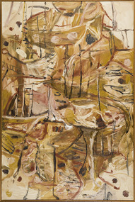
Painting, 'Wattamalla Scrub' by David Rankin, 1985
David RANKIN (1946- ) Born Plymouth, Devon, England Arrived Australia 1948. Leaving rural New South Wales David Rankin arrived in Sydney in 1967. A largely self taught artist he taught art between 1966 and 1974, with his first exhibition was held in 1968. During the 1970s he established Port Jackson Press publishing fine art prints. In 1983 David Rankin won the Wynne Prize for Australian landscape painting. Rankin lives and works in New York, New York., United States of America. His abstract work is distinguished by its loose, expressionistic use of line. This item is part of the Federation University Art Collection. The Art Collection features over 1000 works and was listed as a 'Ballarat Treasure' in 2007.Abstract paintingart, artwork, david rankin, landscape, available, oils, oil on linen -
 Falls Creek Historical Society
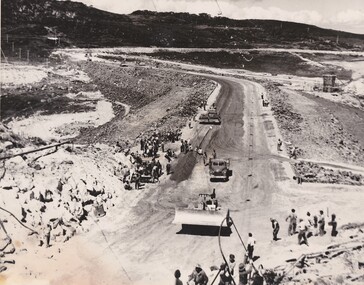
Photograph - Building Rocky Valley Dam Wall
The Rocky Valley Dam is located on the Bogong High Plains, near Falls Creek, Victoria. The dam is man-made and has a capacity of 28,000 megalitres (990×106 cu ft). At an elevation of 1600m, Rocky Valley Dam is the highest significant body of water in Australia. The dam was created for the Kiewa Hydroelectric Scheme. Just a short distance from the heart of the village, the lake provides a playground for a range of aquatic activities. It is also utilised in snow making for the Falls Creek ski resort. Work began on the Rocky Valley Dam site in early 1947 and continued until May. It resumed in October after the winter and a camp for the accommodation of workmen was commenced at this time. Work continued in 1948 with the establishment of work facilities, including the erection of two large excavators. The Rocky Valley Dam was completed in 1959.These images are significant as they capture work carried out to build the wall at Rocky Valley near Falls Creek, VictoriaThree black and white images showing work on the Rocky Valley Dam, Victoriarocky valley dam, kiewa hydroelectric scheme, falls creek -
 Melbourne Tram Museum
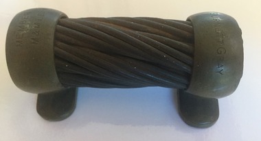
Decorative object - Memento, Melbourne & Metropolitan Tramways Board (MMTB), Melbourne cable tram cable, 1930's
Produced as a gift recording service to the MMTB Board as a Member - presented to Cr. Burnett Gray. Stamped at either end of the object with his name and "MMTB Member" Vic. Parliamentary Website gives details of Cr. Gray, Vic MP - though does not list being a MMTB Board Member. MP for St Kilda 1927 to 1932, Cr for St Kilda 1920 to 1948 - see http://www.parliament.vic.gov.au/re-member/details/1103-gray-alfred-charles-burnett. MMTB Annual Reports: Appointed 1936 (first appearance), until 1954, when the size of the Board was reduced - Order in Council 25/5/1954. The Annual Report for 1936 has a photo of all the Board Members and a listing. See images 1887i2 and i3. See item 7682 for a sample of asection of rope.Demonstrates a MMTB produced gift to thank a Board member for his service.Memento - comprising a section or short length of Melbourne cable tram cable contained or mounted within two cast brass sections as a gift.trams, tramways, mmtb, st kilda, councillors, cables, cable ropes, cable trams -
 4th/19th Prince of Wales's Light Horse Regiment Unit History Room
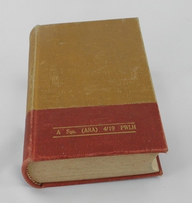
Book, Australian Army, Australian Edition of Manual of Military Law 1941
Law manual applicable to Australian Army personnel from 1941. This effectively applied British military law. In 1982 the Defence Force Discipline Act of the Australian Parliament established a framework of military law for Australia's circumstances. Hard cover bookOn front cover in gold lettering- "A Sqn (ARA) 4/19 PWLH" On fly leaf, rubber stamps - "A SQN 1 CAV REGT. Inscription in red ink - "This book is the personal property of ; -J.B.Larkman" and rubber stamp - "WO2 SSM A SQN" On title page - Rubber stamps - "A Sqn (ARA) 4/19 PWLH" and "A SQN 1 CAV REGT" Detailed records of amendments entered in red ink on Amendments pages from Serial 1, 30 Nov 41 to Serial 9, 31 July 1948 military law, world war 2 -
 Ringwood and District Historical Society
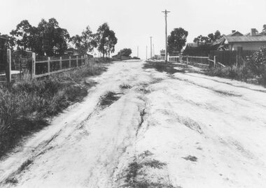
Photograph, Barkly Street, Ringwood - c1948
Black and white photograph of unmade road in poor condition. Houses in background.Typed below photograph, "Barkly St., Ringwood c.1948". Catalogue card states, "Taken about 100 yards down from Wantirna Road. Car probably going south along Wantirna Road. House far right now block of flats (Sept. 1975) but next two houses up street are there. Haig St. just behind car. Fence on house to left still there and curved front path. Shop visible corner Haig St. to left of big pole still there." -
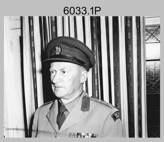 Bendigo Military Museum
Photograph - Directors of Survey Army Headquarters, c1942-1967
This is a set of two photographs of Directors of Survey Army Headquarters circa 1942 to 1967. COL Lawrence FitzGerald OBE was Director from 1942 to 1960. He received the Order of the British Empire in 1948 for his service in WW2. Although it is not known when BRIG Lawrence FitzGerald OBE was promoted to Brigadier, it is possibly an honorary promotion on his retirement in 1960. He served in the Australian Army from 03 September 1923 to 05 January 1960. COL Lawrence FitzGerald OBE was succeeded by COL Donald Macdonald AM, whose appointment to Director was from 1960 to 1967. COL Macdonald AM was promoted to Brigadier on his retirement before assuming the honorary position of Colonel Commandant of the Royal Australian Survey Corps. He served in the Australian Army from 01 January 1936 to 22 March 1960.This is a set of two photographs of Directors of Survey Army Headquarters circa 1942 to 1967.The photographs were printed on photographic paper and are part of the Army Survey Regiment’s Collection. They were scanned at 300 dpi. .1) - Photo, black and white, c1950s. D-SVY COL Lawrence FitzGerald OBE. .2) - Photo, black and white, c1960s. D-SVY COL Don Macdonald AM, MID. .1P to .2P – no annotationsroyal australian survey corps, rasvy, army survey regiment, army svy regt, fortuna, asr -
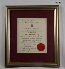 Bendigo Military Museum
Certificate - CERTIFICATE, LIFE MEMBERSHIP 1956, National HQ RSSAILA, C.1956
William John TURNER served on the Committee of the Bendigo Sub Branch from 1948 - 1951, 1953, 1955 - 1958, he was Jnr Vice President during the 1953 - 1958 years. His fund raising and other positions are well documented in Cat No 8029 re the submission for the Life Membership. William Turner had pre WW1 military service in the 67th BN Bendigo area as a Cpl in the Machine Gun section for 2 years. He enlisted in the AIF No 3627 in the 8th Reinforcements 21st BN age 19 years 6 months on 10.7.1915, embark for Eygpt 29.12.1915, transfer to 60th Bn 26.2.1916, promoted Cpl 25.3.1916, embark for France 29.6.1916, WIA 24.4.1918 GSW right wrist, rejoin unit 23.7.1918, promoted Sgt, transfer to 59th Bn 25.9.1918, RTA 15.5.1919, discharged from the AIF 22.8.1919. Certificate framed, frame is timber gold colour, certificate backing is maroon, certificate has ornate edge, all print in blue and black with a red seal at the bottom RH corner. At the top is R.S.S.A.I.L.A followed by the RSL logo then the details of the person receiving and signed.Main points; “This is to certify that Mr W.J. Turner has been awarded Life membership of the Returned Sailors, Soldiers & Airman’s Imperial League of Australia for services rendered as a member of Bendigo Sub Branch Vic” “Dated Canberra 21st Day of November 1956, ................Federal President J Neagle General Secretary”brsl, smirsl, life membership -
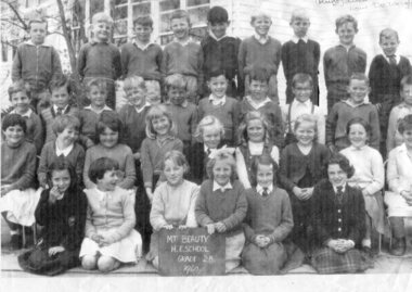 Kiewa Valley Historical Society
Photograph – Mt Beauty Higher Elementary School Grade 2B, 1960 – Black and white photocopy of original photograph
On Feb 3rd 1948, the Mt Beauty State School was opened with 28 pupils in all grades up to VII. Classes began in the SECV Recreation Hall, which was converted to classrooms during the school week and returned to a recreation hall on weekends for motion pictures and social occasions for SECV workers and their families. A new school building was opened in 1950 on the current school site, with an enrolment of 170 primary and secondary students. A further extension of 4 buildings was added in 1951 with a population increase to 303 students. In May 1953, the status of the school was raised to Higher Elementary School with a total of 403 students. In 1958, the school population rose to a high of 617 students with 436 in primary and 181 in secondary. In 1964, the status of the secondary section of Mt Beauty HES was raised to a High School and was moved to separate facilities in the west of town in September 1964 Pictorial history of children who attended Mt Beauty Higher Elementary School in 1960. Many of the students would have had parents working on the Hydro-Electric Scheme in and around Mt Beauty. Many of the children would also have been the descendants of parents who immigrated to Australia as foreign workers on the Hydro Electric Scheme such as Alex Van De Ruijt, whose parents were Dutch. Photocopy of a black and white class photograph of Mt Beauty H E School Grade 2B, 1960 Back row: Lawrence Woods, John Wayne, Terry Hertzog, Phillip Jervies, ?, Alex Van De Wright , ?John Sigmund, Wayne Shoebridge, Brian Harkin 3rd row: Doug Newbound, Roy Hetherington, ? Kevin Hills, Peter Renshaw, ? Grenville Gerecke, ?, Ken Thomas, Detlef Rueff, ?, not in picture Berndt Homfeld 2nd Row, ?, Lyn Plant, ?, Gabrielle Sigmund, ? Pauline Gerecke, Christine Harmer, ?, Lesley McDonald, not in picture, Jenny Richardson Front Row, ? Christine Pennery, Robyn Symons, ?, ?, Sue Mckendrick, ?, ? with a name may not be correct Chalk Board at front of children in photograph – MT BEAUTY H.E.SCHOOL GRADE 2B. 1960 Handwritten in top right hand corner of photograph, with arrow pointing to the boy 4th from the right Alex Van De Auigh (Ruijt) dutch now De Wright Handwritten on back of photograph – Top row: 6 from left (4th from Right) mt beauty school -
 Kiewa Valley Historical Society
Photographs –Collection of 10 copies and original black and white photographs and printed articles relating to skiing on the Bogong High Plains
After World War II, the Kiewa Hydro-Electric Scheme was started in the Kiewa River Valley by the State Electricity Commission of Victoria. On land previously used only for summer cattle grazing in the natural alpine grasslands, the first ski lodge was built in 1948 by workers from the hydro scheme as skiing was a popular recreation. Many of the hydro employees were of European background and had grown up enjoying skiing and snow sports in their homelands and were keen to continue to pursue their winter sports interests. The first lift, a rope tow, was built in 1951 at Falls Creek and the first chairlift in Australia was constructed there in 1957. Two T-Bars were opened in 1961. In 1964, the Victorian Municipal Directory recorded that Falls Creek had 29 ski club lodges and 16 commercial lodges. The area became a popular tourist destination for both winter and summer sports.: Employees of the State Electricity Commission of Victoria in the Kiewa River Valley were the earliest skiers on the Bogong High Plains and built one of the first ski lodges at Falls Creek. They were amongst those pivotal in the development of the skiing and tourist industry at Falls Creek and on the Bogong High Plains. Collection of 10 copies and original black and white photographs and printed articles relating to skiing on the Bogong High Plains. Some pieces have been enlarged to A3 poster size copies for display purposes 1. Copy of black and white photograph of group of skiers at Falls Creek 2. Copy of photograph of early skier on Bogong High Plains with temporary buildings and tents in the background 3. Copy of photograph of 3 skiers on Mt McKay 4. Copy of SECV photograph of Rocky Valley Camp under snow 5. Early sepia photograph of Falls Creek village with skiers in the foreground 6. Copy of a page from booklet (SECV?) promoting the benefits of owning a holiday home in the Bogong Village area 7. Copy of a page from booklet (SECV?) promoting the benefits of holidaying in and around Falls Creek/Mt Beauty 8. Panoramic view of ski fields with skis in the foreground 9. Photograph of young skier (identity unknown) 10. Photograph of 2 male skiers (identity unknown) performing a small jump 1. Bogong Ski Club Members & Friends 1944 2. Jack Neve – electrician. Rocky Valley 3. 17.5.55 Skiers ascending Mt McKay 4. State Electricity Commission of Victoria. Date:17.8.55 No:K8132 Kiewa Hydro Electric Works. Rocky Valley Camp – From Engineering Office 5 & 9 No markings 6 & 7 Short article relating to photos on each page 8. Handwritten signature on rear of photo (Sandra Conea) 10 Faded unreadable photographers stamp and handwritten numbers 6875 on rear secv; bogong high plains; skiers; falls creek; tourism -
 Kiewa Valley Historical Society
Photographs – Bogong High Plains - Set of 16 black and white photographs mounted back and front on 3 pieces of heavy black card likely removed from a photograph album
After World War II, the Kiewa Hydro-Electric Scheme was started in the Kiewa River Valley by the State Electricity Commission of Victoria. On land previously used only for summer cattle grazing in the natural alpine grasslands, the first ski lodge was built in 1948 by workers from the hydro scheme as skiing was a popular recreation. Many of the hydro employees were of European background and had grown up enjoying skiing and snow sports in their homelands and were keen to continue to pursue their winter sports interests. The first lift, a rope tow, was built at Falls Creek in 1951 and the first chairlift in Australia was constructed there in 1957. Two T-Bars were opened in 1961. In 1964, the Victorian Municipal Directory recorded that Falls Creek had 29 ski club lodges and 16 commercial lodges. The area became a popular tourist destination for both winter and summer sports.Employees of the State Electricity Commission of Victoria in the Kiewa River Valley were the earliest skiers on the Bogong High Plains and built one of the first ski lodges at Falls Creek. They were amongst those pivotal in the development of the skiing and tourist industry at Falls Creek and on the Bogong High Plains. Black and white photographs of varying sizes mounted decoratively on heavy black Card. Some pages display a brief description printed in white ink 1. 4 photographs- displayed diagonally across page. 2 pictures of a group of men standing in the snow in front of a car with a loaded trailer behind. 1 photo of skiers. 1 photo of show hanging in tree branches. 2. 2 photographs- showing Upper Kiewa Road with snow in the background 3. 3 photographs- of skiers and 1 photo of 2 of men posing in the snow & 1 photo of 2 men posing shirtless in warmer weather. 4. 2 photographs- arranged diagonally on page showing early buildings and construction at Bogong Village 5. 2 photographs- 1 showing view of Bogong Village from higher up the mountain. 1 showing early Bogong High Plains road 6. 1 photograph- showing view down along Kiewa Valley from higher up in the mountains 1. Handwritten in white ink – A TRIP TO THE PLAINS 2. Handwritten in white ink – UPPER KIEWA ROAD MT FAINTER IN BACKGROUND 3 – 6. No markings bogong village; upper kiewa road; bogong high plains; falls creek; skiers -
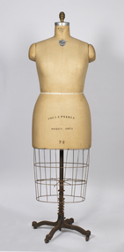 Warrnambool and District Historical Society Inc.
Functional object - Dressmaker's model, Wolf Form and Co. (New York), 1971
This dressmaker's model has been made by a New York firm (1971 model) and comes from the Fletcher Jones Factory in Warrnambool. It would have been used for making and displaying ladies' clothing made at the factory. David Fletcher Jones (1895-1977) served in World War One and in the 1920s set up as a travelling hawker selling drapery in Western Victoria. In 1924 he opened a men's wear shop in Warrnambool and manufactured in sute. In 1946 a Fletcher Jones shop opened in melbourne and in 1948 a factory was established in Warrnambool with a new company, Fletcher Jones and Staff begun in 1951. The company initially specialized in men's trousers but later expanded into both men's and women's clothing. It became an Australia-wide company known throughout the country until it ceased in 2011 and the Warrnambool factory buildings were sold.This dressmaker's model is of considerable interest as a memento of the Fletcher Jones and Staff Company, founded in Warrnambool, employing many local people for a great number of years and known throughout Australia for its quality products and pioneering business model as a founder and staff co-operative.This is a dressmaker's model with the body section (bust and torso) having a fabric cover over a wooden core. The top section is bronze-coloured with a silver rim. Beneath the body section is a wire frame and a metal base on castors. The castors are rusty and the fabric is broken in places. Collapsible model 1971 22 WOLF FORM Registered perfect model forms N Y 140 5th Avefletcher jones and staff, fletcher jones factory warrnambool, warrnambool history -
 Warrnambool and District Historical Society Inc.
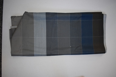
Textile, Fletcher Jones, Mid 20th century
This piece of cloth came from the Fletcher Jones factory in Warrnambool. David Fletcher Jones (1895-1977) served in the First World War and in the 1920s set up as a travelling hawker selling drapery in the Western District of Victoria. In 1924 he leased three shops in Liebig Street, Warrnambool and in 1928 he moved to the Koroit/Liebig Streets intersection with his Man’s Shop. He manufactured men’s clothing on site. In 1931 he moved the business into a new two-storeyed building on the site. He opened a Fletcher Jones shop in Melbourne in 1946 and in 1948 a factory was established in Warrnambool. In 1951 the business of Fletcher Jones and Staff was established. The company expanded and became known Australia- wide, firstly for the production of men’s trousers and later both men’s and women’s clothing. By 2011 the Warrnambool factory was sold and the company was dissolved. This piece of material is of interest as an example of the cloth used in the Fletcher Jones factory in Warrnambool. The Fletcher Jones clothing company, known Australia-wide, was one of the important industries based in Warrnambool in the 20th and early 21st centuryThis is a bolt of check corded material in grey and blue tonings. It is stained in various places.fletcher jones clothing stores, warrnambool, history of warrnambool -
 Warrnambool and District Historical Society Inc.
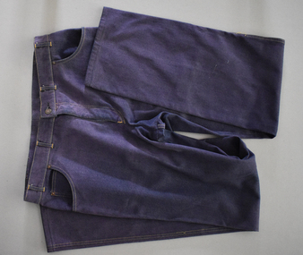
Textile, Fletcher Jones, Men's Fletcher Jones Jeans, Early 21st century
This pair of jeans comes from the Fletcher Jones factory in Warrnambool. David Fletcher Jones (1895-1977) served in World War One and in the 1920s set up as a travelling hawker selling drapery in the Western District of Victoria. In 1924 he leased three shops in Liebig Street Warrnambool and in 1928 he moved the business to the corner of Koroit and Liebig Streets with his Man’s Shop. He manufactured men’s clothing on site. In 1931 a new set of buildings was erected on the site and Fletcher Jones moved into the new building. In 1946 a Fletcher Jones shop was opened in Melbourne and in 1948 a factory was opened in Warrnambool with a new company Fletcher Jones and Staff established in 1951. This company became known Australia-wide, firstly for the production of men’s trousers and later for both men’s and women’s clothing. By 2011 the factory was sold and the company dissolved. These jeans are retained as an example of the clothing made at the Warrnambool Fletcher Jones factory. The Fletcher Jones clothing company was one of the most important businesses in Warrnambool in the 20th century. This is a pair of blue cotton jeans pants with yellow stitching and a metal zip The garment has four pockets. The back pocket has the maker’s label and there are two labels attached to the inside. The front inside top section is lined with white material. ‘Fletcher Jones Australia’fletcher jones clothing company, history of warrnambool -
 Federation University Historical Collection
Document - Document - Course Outline, E J Barker: Ballarat School of Mines; Course Outlines for Applied Mechanics IIIB, - Fluid Mechanics and Machines
Collection of papers used by E J (Jack) Barker when he was teaching at Ballarat School of Mines. They are Applied Mechanics courses - Fluid mechanics and Machines. Jack chose to do Engineering while still at Footscray Technical School as it gave access to Diploma Courses and tertiary studies. This enabled him to enter the University of Melbourne and do a Bachelor in Mechanical Engineering - 1945, 1946, and 1947. In 1948 he did a Diploma in Education at Melbourne University. From this path he was able to follow a career in teaching and his first appointment was at the School of Mines in Ballarat, (SMB) 1949. He became the first Vice Principal of SMB in 1960 and then Principal in 1964 to 1976. From 1976 to his retirement in 1987, he was the Foundation Director of Ballarat College of Advanced Education (BCAE). The Library building at Mount Helen Campus is named after him.Lined pages - hand written Printed pages .1: Applied Mechanics IIIB Fluid Mechanics .2: Applied Mechanics IIIB Machinese j barker, jack barker, footscray technical school, melbourne university, engineering, diploma of mechanical engineering, diploma of electrical engineering, school of mines ballarat, smb, diploma in education, vice principal, principal, foundation director, ballarat college of advanced education, bcae, bachelor of mechanical engineering, library, mount helen campus, applied mechanics - fluid mechanics, applied mechanics - machines, course material