Showing 2789 items
matching george road
-
 Hume City Civic Collection
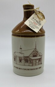
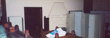
Container - Port Crock, Jeff Cossum, Sunbury Court House 1885
This is a port crock with No. 89 of a special edition of 150 crocks commemorating the restoration of the Old Sunbury Court House. The restoration of the old courthouse which was built in 1885 with an extension to the front and right hand side added in 1965 before the courthouse closed in 1989. The courthouse was restored and reopened in February 1993 as the Visitor Information Centre.The Sunbury Court of Petty Sessions building was built in 1885. Extensions were added in 1965 with the courthouse closing in 1989. After the closure local residents formed a committee to save the courthouse and for it to be used for the benefit of the community this was achieved and with the Shire of Bulla council help was restored and the building reopened as the Sunbury Visitor Information Centre in 1993. The Visitor Information Centre closed and shifted across the road to the Hume Global Learning Centre.A cream and brown stoneware port crock with a small handle that has a paper tag tied to the handle with raffia. There is a broken cork in the neck of the flagon."SUNBURY COURTHOUSE 1885"sunbury court house, goonawarra vineyard, shire of bulla, cossum, jeff, sunbury, george evans collection -
 Mission to Seafarers Victoria
Slide - Glass slide, Black and white, circa 1921
This image provides an additional later modified building view to that of the image of the original single storey building image published on back page of the 1910 MTS Annual Report. According to the Annual Report of 1915 the plans to build a residence on top ( the 2nd storey ) of the Port Melbourne building got the go ahead to commence and opened 1916. Originally designed by architect, Frederick Williams, who built the first brick Mission at Port Melbourne in the 19th C. Walter Butler was commissioned for the second storey.The Port Melbourne building in the image established in the 19th C., still survives. It was a key centre of operations for the Mission prior to the building of the Mission near Australian Wharf in 1907 and prior to the eventual opening of the current "Central Mission" in 1917. NB operations of The Port Melbourne Branch Mission were eventually transferred to the King George V memorial Building, dedicated in December 1937 but demolished in 1995. The Mission depicted here still survives as part of an apartment complex on the corner of Nott st.Positive photograph on medium format glass slide ; b & w image of brick building taken from a corner street level view, with upper storey at one end on glass transparency with a flagpole and flag (Flying Angel) just discernible. The slide is edged with adhesive tape.missions to seamen institute, mission building, frederick williams, walter butler, port melbourne, beach road, mission to seafarers, nott street -
 Mission to Seafarers Victoria
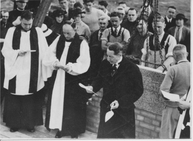
Photograph - Photograph, Black and white, Herald Sun, 18 May 1937
On 18 May 1937, Lord Huntingfield, Governor of Victoria (14 May 1934 – 4 April 1939) layed the foundation stone of the last of the missions built in Melbourne. The Mission to Seamen, Port Melbourne opened in December 1937, superceded the original 19th C building and service point in Port.Demolished in the late 20th C by developers the building was of architectural significance and funded originally by Alfred Nicholas who gifted 18,000 pounds. An indicator of the importance of shipping and seafarer welfare as regarded by Industry and business during the interwar years of the 1930s. This photograph is a record of the founding of the building. The stone is now part of the bluestone wall on Beach Road, Port Melbourne. The Mission was given the name: George V Memorial Institute, and the concert hall was given the name Huntingfield Hall.A black and white photograph depicting the laying of a foundation stone. Photograph of two clergymen standing to one side of the Governor of Victoria (1934-1939), Lord Huntingfield, who is holding a trowel in his left hand. A foundation stone, resting on a low brick wall is thought to be the granite foundation stone of the Port Melbourne Mission. A small crowd of approximately 21 people are gathered behind the wall. Back of photograph stamped, "Herald Feature Service Melbourne".port melbourne, beach road, lord huntingfield, art deco, alfred nicholas, foundation stone, trowel, harry a. norris, george v memorial institute, port melbourne mission, 1937 -
 Lorne Historical Society
Plaque - Spotters Plaque, Tribute plaque to the local Members of the Volunteer Air Observers Corps ( spotters)
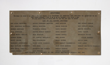
In World War 2 residents of Victoria were concerned about enemy attack so a series of Spotters Huts were established along the coast. In Lorne the Spotters Hut was at Queenspark in the old recreation building. Many locals volunteered their time. The plaque was made by the Lorne Historical Society to honour these people who volunteered to join the Air Observers Corp. A rectangular thin Metal sheet , with black printing. This plaque was made in 1997 as a project of the Lorne Historical Society to pay tribute to the Spotters who worked in the spotters cabin at Queens Park Lorne during the Second World War. It listed all the names of the know Spotters, Win Allen, Nita Armistead, George Armitage, Olga Armitage, Grace Brown, George Crabbe, Monty Craig’s, Margaret Cunningham, Marj Gaylord, Marj Grant, Annie Stirling, Margie Fairbairn, Sheila McIntyre, Wilhemena Morris, Murray Morton, Nick Murnane, Eva Norton, Miss Pethabridge, Eileen Quick, Chas Read, Rev Ken Robert’s, Jack Stirling, Fred Harlock, Nellie Harlock, Cleve Herbert, Joyce Herbert, Hubert Howell, Bert Hughes, Helen Hughes, Enid Jarrett, Alice Kendrick, Marion Kendrick, Rowley Valentine, Mrs G Schram, Don Stewart , Hector Stribling, Cyril Barcoe, Rev Wilson, Kevin Dare, Cliff Green, Shirley Heathcote, Murray Milne. The plaque was placed on the Spotters Hut in 1997 but removed when the hut was remodeledspotters, world war 2, queens park, second world war -
 Kew Historical Society Inc
Photograph - Former Kew Police Station : Carpark, 1996
A civic campaign for new public offices developed in Kew in the 1880s. After much deliberation, the location chosen was the junction of Bulleen and Cotham Roads. The buildings were designed by George Watson and John Henry Harvey, architects within the Department of Public Works (Victoria). Building was commenced in 1887, and after one year, the buildings were opened. The Post Office was transferred to the new Commonwealth Government in 1901. The Police Station and Court House, sold by the Victorian Government to the City of Boroondara in 2007, are now a community cultural centre and performing arts venue.The buildings were listed on the Victorian Heritage Register Register (HO885) in 1991. They are historically and architecturally significant to the State of Victoria because Watson and Harvey's designs exhibit diversity in integrating civil offices, they accommodate the apex of road junctions, and they demonstrate a departure from the contemporaneously favoured High Victorian Classical to the Queen Anne style in the design of civic buildings.View of the carpark at the rear of the Kew Police Station which faces Cotham Road. The garage is a twentieth century addition.Nilkew police station, kew court house, public office - kew (vic.) -
 Kew Historical Society Inc
Photograph - Former Kew Court House : Court Room, 1996
A civic campaign for new public offices developed in Kew in the 1880s. After much deliberation, the location chosen was the junction of Bulleen and Cotham Roads. The buildings were designed by George Watson and John Henry Harvey, architects within the Department of Public Works (Victoria). Building was commenced in 1887, and after one year, the buildings were opened. The Post Office was transferred to the new Commonwealth Government in 1901. The Police Station and Court House, sold by the Victorian Government to the City of Boroondara in 2007, are now a community cultural centre and performing arts venue.The buildings were listed on the Victorian Heritage Register Register (HO885) in 1991. They are historically and architecturally significant to the State of Victoria because Watson and Harvey's designs exhibit diversity in integrating civil offices, they accommodate the apex of road junctions, and they demonstrate a departure from the contemporaneously favoured High Victorian Classical to the Queen Anne style in the design of civic buildings.View of south wall of the former Kew Court House, which when the photo was taken had been converted into a section of the Kew Police Station, and used as a briefing and locker room.kew court house, kew police station -- high street -- kew (vic.), public offices -- kew (vic) -
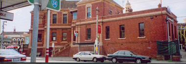 Kew Historical Society Inc
Photograph - Former Kew Post Office : Cotham Road elevation, 1996
A civic campaign for new public offices developed in Kew in the 1880s. After much deliberation, the location chosen was the junction of Bulleen and Cotham Roads. The buildings were designed by George Watson and John Henry Harvey, architects within the Department of Public Works (Victoria). Building was commenced in 1887, and after one year, the buildings were opened. The Post Office was transferred to the new Commonwealth Government in 1901. The Police Station and Court House, sold by the Victorian Government to the City of Boroondara in 2007, are now a community cultural centre and performing arts venue.The buildings were listed on the Victorian Heritage Register Register (HO885) in 1991. They are historically and architecturally significant to the State of Victoria because Watson and Harvey's designs exhibit diversity in integrating civil offices, they accommodate the apex of road junctions, and they demonstrate a departure from the contemporaneously favoured High Victorian Classical to the Queen Anne style in the design of civic buildings.View of the Kew Post Office, opened in 1888 which sits at the intersection of High Street and Cotham Road.The extension of the building at right was constructed in circa 1941. This view is of of the Cotham Road elevation.kew post office, cotham road -- kew (vic.), public offices -- kew (vic.) -
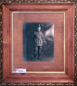 City of Moorabbin Historical Society (Operating the Box Cottage Museum)
Photograph - Alonzo Box in Army Uniform c1915, Unrecorded, c1915
Alonzo Box was the nephew of William and Elizabeth Box who resided in the Cottage 1865 - 1913. He was the 9th child of John Box 1841 - 1913 and Martha Sheldrake Box who lived in Oakleigh, Alonzo enlisted in the Army and landed at Gallipoli 25/41915. After the evacuation to Egypt he served in France and Flanders and returned to Melbourne February 1918. Alonzo was a pavier / pitcher who was employed to lay the bluestone drains for the roads and sewerage channels in Moorabbin Shire - a skilled and well paid occupation. Alonzo Box was the 9th child of John Box ,who emigrated to Australia in 1854 with his parents, George and Mary Box , and siblings who included William Box. Alonzo enlisted in the 1st AIF and landed at Gallipoli 25/4/1915. After the evacuation to Egypt he served in France and Flanders before returning to Melbourne in February 1918. He married Mary Closter in June 1918. His elder sister Rebecca, who was a missionary in China, sent a bolt of hand embroidered Chinese silk to Mary for her Wedding Dress. This unique dress is on display at Box Cottage Museum and is recorded on the Australian Dress Register 2015.A large photograph in a wooden frame of Alonzo Box 1881-1958 in 1st AIF Army Uniform c 1915box william, box elizabeth, box alonzo, box mary, closter mary, moorabbin, brighton, bentleigh, ormond, mckinnon, market gardeners, pioneers, early settlers, paviers, roads, sewers, world war 1914-1918, anzac, gallipoli, uniforms australian army, box john, sheldrake martha -
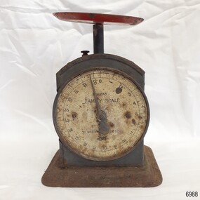 Flagstaff Hill Maritime Museum and Village
Instrument - Scale, George Salter & Co, Circa 1921
The Hughes’ Family Scale No. 48 is a spring balance scale. It uses the Imperial measurements of ounces and pounds. There are 16 ounces (OZ) in one pound (LB), and each pound equals approximately 454 grams in Metric measurements. Scales have been used to measure and compare items for value for centuries. A weight was placed on one side of a balance and the object was placed on the other. Adjustments were made to either the weight or the object until the balance was horizontal, which meant that each side was the same weight. The Salter family business began in 1760 with spring makers, Richard and William Salter. In the late 18th century, Richard Salter invented the spring scale, where the weight of an object on the tray of the scale causes pressure on a spring in the scale. The pressure caused by gravity was then measured to calculate the weight of an object. Spring scales are still used today along with the more recent and accurate digital scales. The company began manufacturing in West Bromwich, England, in 1770. The firm was taken over by William’s sons, John and George. In 1824, after the death of John, the firm became George Salter & Co. The company produced a wide variety of products, including Britain’s first bathroom scale and the first English typewriter. In 1884 the Salter Trademark of a Staffordshire knot pierced by an arrow was registered. After over 100 years of manufacturing, the company was bought out by Staveley Industries, which was bought by Weigh-Tronix, and then that company was bought by HoMedics Company in 2004.This scale was made by Salter, the company that invented the balance scale, the first British bathroom scale and the first English typewriter. The scale represents the domestic equipment used for measuring in food preparation over 100 years ago. Modern kitchen scales are still using the same principal, along with scales used in business and industry.Scale; a domestic spring balance scale for measuring weight from 0 to 20 pounds. The scale’s grey metal case has a round white dial on the front with black markings, an arrow indicator and a round shallow metal bowl on a pedestal at the top. The scale is raised on a rectangular metal base with outward-sloping sides. An adjustable screw is on the dome top. The scale is marked from 0 to 20 pounds, with each pound marked in 1-ounce increments. The scale is named the Hughes Family Scale No. 48 and was made in Britain by Salter.“HUGHES’ / FAMILY SCALE / No. 48” “BRITISH MADE” “TO WEIGH 20 LBS BY 1 OZ” “SALTER” above logo [knotted rope with an arrow through loops]flagstaff hill, warrnambool, maritime museum, maritime village, great ocean road, shipwreck coast, hughes, salter, british made, family scale, no. 48, spring balance, scale, weighing instrument, weights and measures, weighing machine, kitchen utensil, baking accessory, domestic equipment, cookware, bakeware, kitchen scale, kitchen accessory, food preparation, recipes, cooking, measuring -
 Eltham District Historical Society Inc
Photograph, Jim Connor, Former CBA branch, 810 Main Rd, Eltham, 6 January 2000
The little yellow and orange brick at 810 Main Road, Eltham, just in front of the Uniting Church (formerly Methodist Church) on the corner of John Street in more recent times has been used as an Opportunity Shop by the Eltham Uniting Church however the operations outgrew the tiny building and the shop moved to inside the Church hall. This building was once the Eltham agency of the Commercial Bank of Australia. Measuring just 3.6 x 4.5 m inside, it was built in 1878 by George Stebbing and is said to have stored gold in the early Eltham-Research mining days. It was also once the scene of an armed hold-up. Thursday, December 15, 1949, the quiet little bank was embroiled in an infamous wild shoot-out between a daring thief and two bank officers. Today, the building still carries the scars ; a bullet hole remains visible in a cedar bench testifying to the events that played out that day.jim connor collection, uniting church, main road, eltham, cba bank, opportunity shop, 2020-01-06 -
 Eltham District Historical Society Inc
Photograph, Jim Connor, Former CBA branch, 810 Main Rd, Eltham, 10 July 2023
The little yellow and orange brick at 810 Main Road, Eltham, just in front of the Uniting Church (formerly Methodist Church) on the corner of John Street in more recent times has been used as an Opportunity Shop by the Eltham Uniting Church however the operations outgrew the tiny building and the shop moved to inside the Church hall. This building was once the Eltham agency of the Commercial Bank of Australia. Measuring just 3.6 x 4.5 m inside, it was built in 1878 by George Stebbing and is said to have stored gold in the early Eltham-Research mining days. It was also once the scene of an armed hold-up. Thursday, December 15, 1949, the quiet little bank was embroiled in an infamous wild shoot-out between a daring thief and two bank officers. Today, the building still carries the scars ; a bullet hole remains visible in a cedar bench testifying to the events that played out that day.jim connor collection, uniting church, main road, eltham, cba bank, opportunity shop, 2023-07-10 -
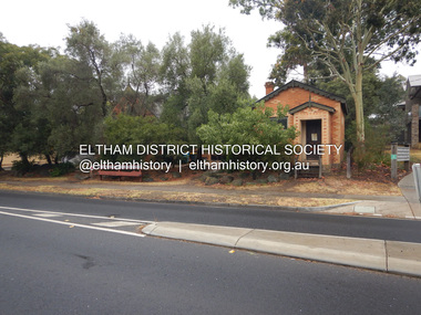
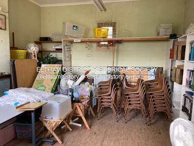
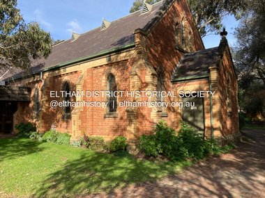 Eltham District Historical Society Inc
Photograph, Jim Connor, Eltham - Montmorency Uniting Church, 810 Main Rd, Eltham, 10 July 2023
Located on the corner of Main Road and John Street, the church first served the community as the Eltham Wesleyan Church since 1881. It became the Eltham Methodist Church in 1902, the year it united with the Primitive Methodists. Eltham Wesleyans first worshipped together in the home of William and Mary Crozier, on 24 acres bounded by Mount Pleasant Road and Pitt Street. From there they moved to a slab and bark hut in 1855 (this later served as the first school run by David Clark prior to the building of a new school in Dalton Street) and the members then built a chapel in 1858 on Lot 20, Henry Street (later to become the Rechabite Hall and Eltham Public Hall). The present church on John Street was designed by architects Crouch and Wilson in the Early English Gothic style with biochrome brick window frames, buttress heads and pinnacle. Church member George Stebbing built the church, the foundations were constructed with stone from the walls of the first Eltham State Primary School (No. 209) building which collapsed in 1874 and were purchased by Robert David Taylor. Stebbing was also responsible for building St Margaret’s Church and Shillinglaw Cottage. The Roll of Honour, which presently hangs in the church hall (which also doubles as the Opportunity Shop) lists 27 members of the congregation who served in the First World War, 11 of whom never returned. The red-brick Church Hall was opened in 1931 and in 1971 further additions linked the hall and church, including a foyer, vestry, meeting room and toilets reflecting the Eltham style of that time with its simplicity, extensive clear glass, reused baked clay-bricks from the 1881 church, heavy ceiling beams and compressed straw ceiling. On June 26, 1977, the church became part of the new Uniting Church in Australia consisting of the former Methodist and Congregational and most of the Presbyterian Churches. Following of declining numbers of worshippers, the church merged with the Montmorency Uniting Church on June 23, 1996. In 2023 the Uniting church approved a plan to renovate the church. It is understood that the historic church and the hall will be retained, and the building added in 1971 is to be demolished, to make way for a new purpose-built Opportunity shop. The proposed areas to be demolished include the current foyer, toilets, crèche, etc, including the area between the hall and the former RSL. Works are expected to commence mid to late July 2023. The Society was invited by a church member to take photographs of these areas to document them prior to demolition works commencing. Ref: “Nillumbik Now and Then” by Marguerite Marshall (2008)jim connor collection, 2023-07-10, eltham-montmorency uniting church, john street, methodist church, opportunity shop, uniting church, uniting church hall -
 Hume City Civic Collection
Photograph, c1960s
The photograph overlooks former railway land along Vineyard Road which is now a commercial and light industrial estate. It was taken before curbing and footpaths were laid and Vineyard Road was narrow strip of asphalt with the sides of the road unmade.A black and white photograph of Vineyard Road with the Sunbury Railway line visible across the middle distance and the former Sunbury Asylum site in the background.vineyard road, sunbury asylum, sunbury railway line, george evans collection -
 Eltham District Historical Society Inc
Document - Folder, Ness family
James Johnston settled at Kangaroo Ground in 1849. His nephew James Mess joined him and a descendant Robert James Mess changed his surname to Ness. The family became active in all aspects of Kangaroo Ground life. Contents Text (handwritten and transcribed): "The Ness Family, Kangaroo Ground", Joy Ness, 1989. Newspaper article: "True pioneer stock", Diamond Valley News, 2 March 1982. History of the Mess/Ness family Newspaper article: "Ness family are keepers of 140 years of historical knowledge", Diamond Valley News, 4 February 1986. History of Joseph Stephenson and descendants. Newspaper article: "Joy Ness paints native flowers for posterity". Diamond Valley News, 21 October 1986. Life and career of Joy Ness as painter. Newspaper article: "His Cup runneth of with Joy", ?Diamond Valley Leader, 6 December 2000. Bruce and Joy Ness celebrate 60th wedding anniversary. Pencil sketch by Joh Ebeli no date but pre 2004: Portrait of Joy Ness dressed for the Historical Society Parade. Order of Service: Thanksgiving service for the life of Robert Bruce Ness 22 January 1917 / 28 June 2004. Eltham District Historical Society newsletter no date: "Robert Bruce Ness 1917-2004", obituary and extract from Joy Ness's history of the family. Copy of letter from Joh Ebeli to Gwen Orford, no date but ~2004: Describes drawings he made of Robert Bruce Ness when taking part in Diamond Valley Arts Society float and enclosed 3 drawings and a photograph of drawing of the bakers (corner Main Road and York Street Eltham). Eltham District Historical Society newsletter September 2013: "Vale Joy Ness", obituary and extract from Diamond Valley News article of 6 December 2000.Newspaper clippings, A4 photocopies, etcness family kangaroo ground, james johnston, kangaroo ground, pretty hill farm, wellers hotel, betsy sadler, ingleside kangaroo ground, james mess, jane stevenson, ness lane kangaroo ground, view hill kangaroo ground, stte savings bank agency, ruth lettice gosling nee mess, kangaroo ground state school, garden hills kangaroo ground, william mess, joseph mess, isabella mess, james johnson mess, ruth ettie mess, george mess, alexander mess, janes mess, robert david mess, heidelberg agricultural show, diamond creek agricultural show, rober james ness, pearl ness nee mills, william mills, sabina mills, robert bruce ness, beryl ness, vera ness, donald ness, kangaroo ground presbyterian church, kangaroo ground cemetery trust, kangaroo ground tennis club, professor osborne, doctor osborne, joseph stevenson, joy ness, kangaroo ground fire brigade, bruce ness, country fire authority, ship wellington 1837, diamond creek, david christmas, christmas hills, andres harkness, samuel furphy, andrew ross, caledonian gold fields, queenstown now st andrews, mother coleman of kangaroo ground, diamond valley arts society, winifred joy ness, andrew ross museum, eltham art show -
 Glen Eira Historical Society
Album - Album page, Kambrook Road, Circa 1972
This photograph is part of the Caulfield Historical Album 1972. This album was created in approximately 1972 as part of a project by the Caulfield Historical Society to assist in identifying buildings worthy of preservation. The album is related to a Survey the Caulfield Historical Society developed in collaboration with the National Trust of Australia (Victoria) and Caulfield City Council to identify historic buildings within the City of Caulfield that warranted the protection of a National Trust Classification. Principal photographer thought to be Trevor Hart, member of Caulfield Historical Society. Most photographs were taken between 1966-1972 with a small number of photographs being older and from unknown sources. All photographs are black and white except where stated, with 386 photographs over 198 pages. https://vhd.heritagecouncil.vic.gov.au/places/43737 - re 26 Kambrook Road and 345 Balaclava Road corner building: A prominently situated two-storeyed complex of late Victorian buildings consisting of "Wybar's Buildings" occupying the Balaclava Road/ Kambrook Road corner and the "Caulfield Bakery" facing Kambrook Road, separated by a driveway from a single storeyed shop. The main building has a comer splay and balustraded parapet with curved pediments, the words "Wybar's Buildings 1887" having been obliterated but "Caulfield Bakery 1887" with the characteristic wheatsheaf surviving in raised cement work. The walls are stuccoed and richly ornamented with bracketed cornices and keystones with masks extending to the Bakery. The main building is further distinguished by the Masonic symbol of the mason's dividers in the pediment whilst the upper level of the bakery is in overpainted brickwork. The single storeyed shop incorporates the bracketed cornice and consoles characteristic of the main buildings and is in other respects a utilitarian structure. https://vhd.heritagecouncil.vic.gov.au/places/35413 - re 16 Kambrook Road A small late Victorian Italianate villa distinguished by its parapeted window bays either side of a small verandah with encaustic tiled floor. The parapets are balustraded with console enrichment and glazed tiles, the stuccoed surfaces being unpainted. Ornamentation is in other respects undistinguished. https://www.gleneira.vic.gov.au/services/planning-and-building/heritage/heritage-management-plan - re 9-11 Kambrook Road ... they demonstrate most of the commonly employed aesthetic devices characteristic of the Italianate Style including patterned brickwork, patterned slate roofs, cast iron lace verandahs, ornamental stucco work and ashlar boards...https://vhd.heritagecouncil.vic.gov.au/places/43737 - 345 Balaclava and 26 Kambrook Roads HO91 in City of Glen Eira "Wybar's Buildings" at the corner of Balaclava Road and Kambrook Road are important as a prominent late Victorian commercial development incorporating a variety of activities including a bakery and possibly a coffee palace, the latter understood to be unique within the municipality, but characteristic of the period. It is a rare complex of its type in Caulfield and is important also as evocative evidence of the late Victorian Land Boom and the creation of a small now defunct commercial centre at this location by the George Wybrow. https://vhd.heritagecouncil.vic.gov.au/places/35413 - 16 Kambrook Road HO121 in City of Glen Eira ''Hollywood'' at 16 Kambrook Road is of architectural interest for its pavilions which retain their unpainted parapets and ornamental tiles in the manner of other less imposing examples in the immediate locality possibly linked with the builder George Wybar and his son, who undertook substantial projects nearby. Its association with James Yorston, presumably is Yorston of Dickson and Yorston, important builders and estate developers at Caulfield during the Inter war period is of interest. https://www.gleneira.vic.gov.au/services/planning-and-building/heritage/heritage-management-plan - re 9-11 Kambrook Road HO152 Normanby Road/Kambrook Road, Caulfield North Statement of Significance: The Precinct is historically significant for its capacity to demonstrate standards of design and building construction in this part of the municipality during the late Land Boom years and especially just prior to the bank collapse of 1891. The housing stock is representative of the standards of amenity excepted by the middle classes of Melbourne society at the time, including artists, (horse) trainers, jockeys, managers, travellers, journalists and the like, also having a functional link with the activities of the Caulfield Racecourse which forms an important element in the history of the Municipality. The row of attached pairs at 5-11 Kambrook Road and 53-67 Kambrook Road is especially significant in this respect in that the narrow allotments are indicative of the owner/developer’s determination to maximise profits at the height of the Land Boom in 1891...Page 104 of Photograph Album with four photographs (landscape) of three different properties on Kambrook Road.Handwritten: Kambrook Road [top right] / WYBAR'S BUILDING 1887/ INC CAULFIELD BAKERY / [under top right photo] / 16 KAMBROOK ROAD / 1970 HIRST MRS J.N.[under bottom left photo] / 11-9 KAMBROOK ROAD / 1970 9-BUCKLAND MRS L.A / 11- ATKINS MRS N.E. [under bottom right photo] / 104 [bottom right]trevor hart, kambrook road, victorian, caulfield north, parapets, wybar's buildings 1887, caulfield bakery 1887, architectural features, painted bricks, balaclava road, victorian italianate style, houses, bay windows, verandahs, glazed tiles, shops, george wybar, builders, james yorston, dickson and yorston, j n hirst, l a buckland, n e atkins, patterned slate roofs, patterned bricks, cast iron work, attached houses -
 Glen Eira Historical Society
Album - Album page, Bureel (Kooyong Road), Circa 1972
This photograph is part of the Caulfield Historical Album 1972. This album was created in approximately 1972 as part of a project by the Caulfield Historical Society to assist in identifying buildings worthy of preservation. The album is related to a Survey the Caulfield Historical Society developed in collaboration with the National Trust of Australia (Victoria) and Caulfield City Council to identify historic buildings within the City of Caulfield that warranted the protection of a National Trust Classification. Principal photographer thought to be Trevor Hart, member of Caulfield Historical Society. Most photographs were taken between 1966-1972 with a small number of photographs being older and from unknown sources. All photographs are black and white except where stated, with 386 photographs over 198 pages. From: Glen Eira Heritage Management Plan 1996 by Andrew Ward In 1856, John Allee, a builder from Brighton, purchased C.A. 37 on the south-west corner of Glenhuntly and Kooyong Roads. The land comprised just over 45 acres. By 1863, Francis John Sidney Stephen, a lawyer and cousin of J. Wilberforce Stephen, owned most of lot 37. By 1866, Stephen had a built a "small mansion" named ''Burreel". It was a brick house and Stephen lived there until 1882. By 1884, Mrs Buxton of Hillside Terrace, East Melbourne, had purchased the property. Richard Buxton, a gentleman was listed as occupant and the house described as "brick, eight rooms". NAV was £300. Richard Buxton continued residency in 1887 however in 1888, George Allen, music seller, became occupant. At that time the house had thirteen rooms on twenty-three acres of land. Twelve people lived there and NAV was £920. In 1900, Daniel Luxton, stock and sharebroker and the Honourable John Taverner, M.H.A. leased the property. Fourteen people lived there. Mrs Buxton continued as owner. By 1910, ownership had passed to Mrs Mary Neate, who converted the house to a nursing home. The land had been subdivided by 1913 and sold by ''Buxtons Estate". Burreel Avenue, Baxter, Buxton and Hoddle Streets were created. "Burreel" was rated to Burreel Avenue and stood on lot 13 with frontages to Burreel Avenue and Kooyong Road of 198' and 214'. The house had ten rooms. NAV was £60. Mary Neate, a nurse, continued as owner/ operator of ''Burreel" nursing home in 1927. At that time there were sixteen rooms and fourteen residents. NAV was £100. Mrs Neat remained there until 1947. In 1948, the house was turned into apartments. In the 1980's, the Alexander family purchased it and restored it to a private residence.Burreel 331 Kooyong Road, ELSTERNWICK VIC 3185 - Property No B4950 National Trust https://vhd.heritagecouncil.vic.gov.au/places/65648 This is a large and substantially intact example of the grand villas of nineteenth century Melbourne. The bulk of the house most probably was built in 1866-1868 for Francis John Sidney Stephen, a prominent and highly regarded Melbourne solicitor and a member of an illustrious legal family. Stephen conducted a lucrative private practice and in 1845 was appointed first solicitor to the City of Melbourne; a position he held until his death in 1895. He took an active part in the development of Caulfield and was Shire President in 1874 and 1877. He was a resident at Burreel from 1868 to 1882. The house has evolved in stages, the rear wings possibly remaining from a house built during the 1850s. The existing ornate cast iron verandah was probably built between 1882 and 1888 during the residence of Richard Buckhurst Buxted, a notable boom period auctioneer and real estate agent. George Allan, the founder of Allan's music store, was another important occupier from 1888 to 1991. Bureel's essentially residential quality has been retained and the interior has been well preserved. The significance of this building does not rest in any single unusual outstanding architectural feature, or in its association with a particularly prominent member of society in the past, but rather in the consistent integrity of both the interior and exterior, which results in the survival of an outstanding example of this type of residential building and its associations with two notable citizens. Classified:11/08/1990Page 113 of photograph album with 1 photograph of Burreel in its garden.Handwritten: Bureel [top left] / 113 [bottom left]trevor hart, caulfield, caulfield north, kooyong road, thomas king, mansion, 1860's, bureel, burreel, francis john sidney stephen, city of melbourne, shire president, 1850's, verandah, nursing home, john allee, ornamented corner stones, new orleans manner, plaster rendered, mrs luxton, vincent willis, alexander family, victorian architectural style, ornate cast iron work, lawyers, brick houses, richard buxton, richard buckhurst buxton, george allen, george leavis allan, allans music, daniel luxton, john taverner, mary neate, buxtons estate, land subdivision, mary neat, gardens -
 Glen Eira Historical Society
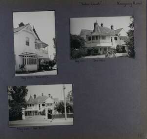
Album - Album page, Tudor Court, Kooyong Road, Dec 1972
This photograph is part of the Caulfield Historical Album 1972. This album was created in approximately 1972 as part of a project by the Caulfield Historical Society to assist in identifying buildings worthy of preservation. The album is related to a Survey the Caulfield Historical Society developed in collaboration with the National Trust of Australia (Victoria) and Caulfield City Council to identify historic buildings within the City of Caulfield that warranted the protection of a National Trust Classification. Principal photographer thought to be Trevor Hart, member of Caulfield Historical Society. Most photographs were taken between 1966-1972 with a small number of photographs being older and from unknown sources. All photographs are black and white except where stated, with 386 photographs over 198 pages. Sands & McDougalls directory of Victoria : 1970 gives address as 141 Kooyong Road, Caulfield North. "Caulfield's Building Heritage" p67 includes that this mansion was originally called Fairhaven, built for George Hope, a dairy farmer. He changed the name to Tudor Court in 1915 when he moved his dairy to Cranbourne.Page 116 of Photograph Album with three photographs (one portrait and two landscape) of different views of Tudor Court in its garden. Handwritten: "Tudor Court" Kooyong Road [top right] / Neg 252 Dec 1972 [under top left photo] / Neg 251 Dec 1972 [under top right photo] / Neg 253 Dec 1972 [under bottom left photo] / 116 [bottom right]trevor hart, caulfield north, kooyong road, mansion, verandah, tudor court, george hope, terracotta tiles, terracotta roof, arched windows, port cochere, square bay window, timber balustrade, columned balcony, receptions, fairhaven, arcare caulfield aged care, 1910's, spire, ridge capping, conical roof, verandahs, victorian architectural style, tudor style, queen anne style, lead lights windows, shingle roofs -
 Glen Eira Historical Society
Album - Album page, 31 Nepean Highway, Circa 1972
... Hawthorn Road and "Glenmoore" (1870) at 1 St Georges Road. trevor ...This photograph is part of the Caulfield Historical Album 1972. This album was created in approximately 1972 as part of a project by the Caulfield Historical Society to assist in identifying buildings worthy of preservation. The album is related to a Survey the Caulfield Historical Society developed in collaboration with the National Trust of Australia (Victoria) and Caulfield City Council to identify historic buildings within the City of Caulfield that warranted the protection of a National Trust Classification. Principal photographer thought to be Trevor Hart, member of Caulfield Historical Society. Most photographs were taken between 1966-1972 with a small number of photographs being older and from unknown sources. All photographs are black and white except where stated, with 386 photographs over 198 pages. Victorian Heritage Database - HO48 - 31 Nepean Highway Elsternwick https://vhd.heritagecouncil.vic.gov.au/places/35531 (at 15/08/2021) "Roseneath" at 31 Point Nepean Road is a bi-chromatic Italianate villa built for William Millar in 1874. It is aesthetically and historically important. "Roseneath's aesthetic value derives from its survival as a substantially intact bi-chromatic brick villa, distinguished by the symmetrical north and south facing bays and by its spacious grounds. Its historical value rests on its comparatively early date and link with Shire councillor William Millar. The choice of bi-chromatic brick, which was highly fashionable at the time, is also of note. "Roseneath" compares with "Cumbernauld" (pre 1872) at 504 Hawthorn Road and "Glenmoore" (1870) at 1 St Georges Road.Page 140 of Photograph Album with three (landscape) photographs of Roseneath on Nepean Highway. Handwritten: 31 Nepean Highway [top right] / 140 [bottom right]trevor hart, verandah, chimneys, porch, decorative brackets, single storey, cast iron columns, return verandah, garden, nepean highway, roseneath, italianate, 1870's, elsternwick, cast iron work, victorian style, polychrome bricks, william millar, slate roofs, brick houses, house names -
 Glen Eira Historical Society
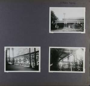
Album - Album page, Heatherbrae, 73 Neerim Road, Circa 1972
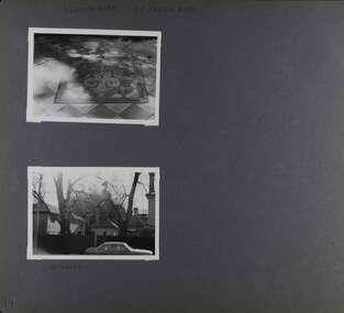
This photograph is part of the Caulfield Historical Album 1972. This album was created in approximately 1972 as part of a project by the Caulfield Historical Society to assist in identifying buildings worthy of preservation. The album is related to a Survey the Caulfield Historical Society developed in collaboration with the National Trust of Australia (Victoria) and Caulfield City Council to identify historic buildings within the City of Caulfield that warranted the protection of a National Trust Classification. Principal photographer thought to be Trevor Hart, member of Caulfield Historical Society. Most photographs were taken between 1966-1972 with a small number of photographs being older and from unknown sources. All photographs are black and white except where stated, with 386 photographs over 198 pages.From Victorian Heritage Database citation for Heatherbrae HO46 https://vhd.heritagecouncil.vic.gov.au/places/120933 (as at 28/10/2020) "Heatherbrae" at 73 Neerim Road, Glenhuntly, is a substantial Victorian residential complex made up of two principal construction stages (pre 1876 and c. 1890) and outbuildings including stables. It is aesthetically, historically and socially significant. Its aesthetic value is demonstrated by the manner in which the two periods of construction survive, the earliest being of greater architectural interest on account of its tower and facade treatment, the latter phase adopting a common villa form. The importance of the complex is heightened by its intact state and surviving outbuildings. "Heatherbrae's" historical significance lies in its link with locally known business man and Shire of Caulfield councillor, John Charles Holland. Its social value rests on its ability to demonstrate a past lifestyle.Page 142 of Photograph Album with four photographs (three landscape, one portrait) of Heatherbrae on Neerim Road.Handwritten: "Heatherbrae" 73 Neerim Road [top right] / 142 [bottom right]trevor hart, verandah, chimneys, decorative brackets, cast iron columns, return verandah, garden, 1870's, intricate lacework, neerim road, booran road, 1880's, 1890's, mansion, john c. holland, bluestone foundations, italianate, iron roofed balcony, cast iron balustrade, balcony, ornamented pediment, mosaic tiles, cast iron lookout, flagpole, george f griffiths, mcgowan, tower, caulfield, heatherbrae, cast iron work, victorian style, john holland, porte-cochere porches, lead lights, george griffiths, mansions, stables, councillors, outbuildings -
 Glen Eira Historical Society
Album - Album page, Heatherbrae, 73 Neerim Road, Circa 1972
This photograph is part of the Caulfield Historical Album 1972. This album was created in approximately 1972 as part of a project by the Caulfield Historical Society to assist in identifying buildings worthy of preservation. The album is related to a Survey the Caulfield Historical Society developed in collaboration with the National Trust of Australia (Victoria) and Caulfield City Council to identify historic buildings within the City of Caulfield that warranted the protection of a National Trust Classification. Principal photographer thought to be Trevor Hart, member of Caulfield Historical Society. Most photographs were taken between 1966-1972 with a small number of photographs being older and from unknown sources. All photographs are black and white except where stated, with 386 photographs over 198 pages.From Victorian Heritage Database citation for Heatherbrae HO46 https://vhd.heritagecouncil.vic.gov.au/places/120933 as at (28/10/2020) "Heatherbrae" at 73 Neerim Road, Glenhuntly, is a substantial Victorian residential complex made up of two principal construction stages (pre 1876 and c. 1890) and outbuildings including stables. It is aesthetically, historically and socially significant. Its aesthetic value is demonstrated by the manner in which the two periods of construction survive, the earliest being of greater architectural interest on account of its tower and facade treatment, the latter phase adopting a common villa form. The importance of the complex is heightened by its intact state and surviving outbuildings. "Heatherbrae's" historical significance lies in its link with locally known business man and Shire of Caulfield councillor, John Charles Holland. Its social value rests on its ability to demonstrate a past lifestyle. Page 143 of Photograph Album with 2 landscape photographs of Heatherbrae on Neerim Road - paving insignia and side view.Handwritten: "HEATHERBRAE" 73 NEERIM ROAD [top] / STABLE [under bottom photo] / 143 [bottom left]trevor hart, chimneys, cast iron columns, return verandah, garden, 1870's, neerim road, booran road, 1880's, 1890's, mansion, john c. holland, bluestone foundations, italianate, iron roofed balcony, cast iron balustrade, mosaic tiles, cast iron lookout, flagpole, george f griffiths, residential villa, caulfield, heatherbrae, victorian style, cast iron work, stables, outbuildings, john holland, george griffiths, councillors, mansions -
 Glen Eira Historical Society
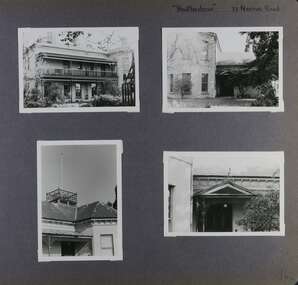
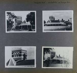
Album - Album page, Fairfield Hall, 225 North Road, Circa 1972
This photograph is part of the Caulfield Historical Album 1972. This album was created in approximately 1972 as part of a project by the Caulfield Historical Society to assist in identifying buildings worthy of preservation. The album is related to a Survey the Caulfield Historical Society developed in collaboration with the National Trust of Australia (Victoria) and Caulfield City Council to identify historic buildings within the City of Caulfield that warranted the protection of a National Trust Classification. Principal photographer thought to be Trevor Hart, member of Caulfield Historical Society. Most photographs were taken between 1966-1972 with a small number of photographs being older and from unknown sources. All photographs are black and white except where stated, with 386 photographs over 198 pages. Glen Eira Heritage Management Plan 1996 by Andrew Ward https://www.gleneira.vic.gov.au/media/4777/heritage_mment_plan_vol_3b.pdf (as of 27/01/2021) - p90 An imposing single storeyed Italianate bi-chromatic brick villa with three staged tower surmounting the entry and facetted corner bay with conical roof. White tuckpointed black body bricks are relieved with reds and stucco work. Gable ends are fretted and there is a concave cast iron verandah to the principal elevations.Victorian Heritage Database (as of 27/10/2020) - HO49 225 North Road Caulfield South https://vhd.heritagecouncil.vic.gov.au/places/42426 "Maniar" (?) is a substantial late Victorian Italianate villa with tower and extensive grounds built for Frederick Curwan, an inspector of the National Bank, in 1890. It is aesthetically and historically important. An imposing single storeyed ltalianate bi-chromatic brick villa with three staged tower surmounting the entry and facetted comer bay with conical roof. White tuckpointed black body bricks are relieved with reds and stucco work. Gable ends are fretted and there is a concave cast iron verandah to the principal elevations. It is aesthetically important as an imposing and substantially intact villa residence demonstrating the changing architectural fashions of the 1890's, evidenced by the use of face brickwork and fretted gables in the Queen Anne manner. It is historically important for the manner in which it demonstrates the lifestyle to which a businessman could aspire during the boom period.Page 150 of Photograph Album with four landscape photographs of Fairfield Hall on North Road.Handwritten: "Fairfield Hall" 225 North Rd cnr Younger Ave [top right] / 150 [bottom right]trevor hart, jenny o'donnell, verandah, porch, tower house, tower, mansion, three storey tower, bichromatic brickwork, fairfield hall, 1890's, george jobbins, conical roofed projecting corner bay, conical roofed bay, timber ceilings, north road, younger avenue, frederick wallis curwan, curwan, italianate, queen anne, australian homestead, arched windows, curved windows, columned parapet, return verandah, fairfield estate, fairfield street, slate roofed, red brick, polychrome bricks, victorian style, cast iron work, caulfield south, maniar, house names -
 Glen Eira Historical Society
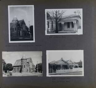
Album - Album page, Orrong Road, Circa 1972
This photograph is part of the Caulfield Historical Album 1972. This album was created in approximately 1972 as part of a project by the Caulfield Historical Society to assist in identifying buildings worthy of preservation. The album is related to a Survey the Caulfield Historical Society developed in collaboration with the National Trust of Australia (Victoria) and Caulfield City Council to identify historic buildings within the City of Caulfield that warranted the protection of a National Trust Classification. Principal photographer thought to be Trevor Hart, member of Caulfield Historical Society. Most photographs were taken between 1966-1972 with a small number of photographs being older and from unknown sources. All photographs are black and white except where stated, with 386 photographs over 198 pages. Victorian Heritage Database H0704 FORMER UNION CHURCH 84-86 ORRONG ROAD ELSTERNWICK https://vhd.heritagecouncil.vic.gov.au/places/428 The Former Union Church, Elsternwick, designed by the architect George de Lacy Evans, and erected in 1889-90 is a building of historical and architectural significance for the following reasons:- (1) it is a rare and well- developed example of the early French Gothic manner as popularised through the muscular Victorian re-interpretation of English architect William Burgess, which in turn were derived from the publications of EE Viollet-le-Duc. Other Victorian cases of detailing derived from Viollet-le-Duc include Barwon Park (1868), the Presbyterian Church at Skipton (1871), the Bourke Street West Police Station by Bindley and Brittingham (PWD) dating from 1888-9 and the Lutheran Manse, East Melbourne by JAB Koch (1890). However, none of these buildings relates closely in form to the Union Church, Elsternwick. The only building which has been identified as closely comparable is The Bairnsdale Court House by AJ Macdonald (PWD) which dates from 1892. (2) the use of bright red brickwork is of significance, as the Former Union Church is believed to be only the second church building in Victoria to employ this material as a matter of conscious choice. Amongst red brick churches, it is thought to be preceded only by Reed, Henderson And Smart's Sacred Heart (1884), a Renaissance inspired design. (3) the building is believed to be a rare, possibly unique, surviving example of a church building erected for dual use by the Congregationalists and Baptists. In 1894 it was bought by the Congregationalists and continued as a Congregational Church until the formation of the Uniting Church.Page 165 of Photograph Album with four photographs, two of a church with the other two of houses on Orrong Road.Handwritten: ELSTERNWICK CONGREGATIONAL CHURCH [under top left photo] / 82 ORRONG ROAD [under top right photo] / 663-1 ORRONG ROAD / SEMI - DETACHED PAIR / 165 [bottom left]trevor hart, elsternwick congregational church, king street, orrong road, church, elsternwick, red brick, former union church, early french gothic style, architects, george de lacy evans, baptist church, conical towers, houses -
Glen Eira Historical Society
Document - CUMBERNAULD
... Hall St. George’s Road Haverfield Frank Haverfield Mrs ...This file contains nine pages about people related to this property: 1/Copy and pasted eight pages taken from Census Records and Trove items. Articles include the death of Thomas Livingstone Cleland during WWI. Various social notes regarding his family up to 1953. There are articles on the W.J. Mathieson family, who also resided there, as well as residing in Benalla. 2/Print from Trove of an article from the 23/11/1934 edition of The North Eastern Ensign (Benalla, Vic) about the wedding anniversary of Mr and Mrs W.J. Mathieson, held at Cumbernauld on 27/10/1934.cumbernauld, thornleigh grange, house names, cleland thomas livingstone, cleland annie, gardeners market, clayton road, ‘hillside’, caulfield, anderson street, cleland sydney, cleland margaret, cleland james, cleland adelaide, cleland robert, cleland bessie adelaide, cleland agnes, cleland lily, cleland alick douglas milkman, cleland aggie, cleland tom h.s. draftsman, cleland kenneth malcolm, cleland ethel, cleland hector, cleland edna may, mathieson w.j., mathieson isabel, burrows f.a. lieut., east st. kilda, hawthorn road, ‘thornleigh grange’, south caulfield progress association, south caulfield junction, caulfield court, jenkins harry, giles alfred, grafton street, elsternwick, dawes john, chloris crescent, st. john’s presbyterian church, mathieson evelyn mary, marks theodore leslie, mathieson kitty, masonic hall, st. george’s road, haverfield frank, haverfield mrs, haverfield robert ross, rynn mary buckley, cyclists, cycling, donald alexander, martin lottie, whitelaw joan, trinity hall, brighton road, gilmore patricia phyllis, brooklyn ave., point nepean road, north road, brighton court, cleland nora, seaview drive, cleland john stuart, mathieson isabella cristina, kalymna grove, mathieson catherine m., tailor, mathieson william james, councillors, social events and activities, births deaths and marriages, anniversaries, world war 1914-18, soldiers -
Glen Eira Historical Society
Ephemera - ROSENEATH, NEPEAN HIGHWAY, 31, ELSTERNWICK
This file contains 8 pages and one property notice. The file contains: 1/descriptions from Andrew Ward’s Heritage Planning Report. Notes on residents of ‘Roseneath’ from 1866 to 1963. Articles include household goods sale, public notices, wills and estate notices from Trove and census record. Details from Ancestry.com 2016. 2/Property sale notice of ‘Roseneath’ dated 04/03/2016 from Leader newspaper.‘roseneath’, house names, point nepean road, elsternwick, bogle andrew esq., auctions, wragge william, wragge mary, wragge william charles, miller william, councillors, rusden street, mcmillan street, subdivision, boyle andrew, merchants, shire of caulfield, east st kilda riding, breckinhill lodge, bogle andrew mrs., wragge w mrs, st kilda cemetery, cemeteries, kirkham councillor, long councillor, riddell councillor, lempriere councillor, ilberry concillor, worthington george, judges, tulloch annie, st kilda ladies benevolent society, worthington mrs, wheeldon isaac, tulloch w.g., breweries, elsternwick, madame berry west company, tulloch and son, mccracken’s brewery, elsternwick station, ‘elderslie’, glenhuntly road, wheeldon sarah, cross anastacia, brick houses, meek alexander charles, meek una eveline, meek david, meek jane, meek james, meek alexander, meek kathleen, meek william, lloyd i. captain, lloyd mary, lloyd nova, lloyd eileen, meek anastasia mary, meek william john, meek monica venus, engineers, marine surveyors, social events and activities, wills and estates, real estate, advertisements -
Glen Eira Historical Society
Article - SHELFORD GIRLS’ SCHOOL AND KINDERGARTEN
... Dora Miss Allison Road school committees mansions stables Hood ...This file contains 9 items relating to the purchase of ‘Helenslea’ for Shelford Girls’ School and its early years there. 1/1 photocopy of a notice advertising a public meeting on 04/12/1922 concerning fundraising for the purchase of ‘Helenslea’ for Shelford Girls’ School, dated 29/11/1922, publication unknown. 2/1 leaflet requesting donations and gifts for the purchase and fitting out of ‘Helenslea’ for Shelford Girls’ School, dated 04/12/1922, publication unknown. 3/1 photocopy of 2 pages from the ‘St Mary’s Church Chronicle’ dated 16/12/1922., describing Shelford’s history, the purchase of ‘Helenslea’ and related fundraising efforts. 4/1 photocopy of an invitation to Mr & Mrs Reeves to attend the dedication of ‘Helenslea’ for use by Shelford Girls’ School on 22/02/1923. 5/1 photocopy of an article and 5 photographs in ‘Punch’, 01/03/1923, about the dedication of ‘Helenslea’ for use by Shelford Girls’ School. The photographs are of various visitors, staff and students with one showing the front of ‘Helenslea’. 6/1 photocopy of a one-page prospectus including rules for Shelford Girls’ School and Kindergarten with a photograph of the school dated approximately 1922-23. Date and publication unknown. The photograph shows ‘Helenslea’ prior to the alterations done for the school. 7/1 Photocopy of a photograph titled ‘Retrospect’ of the staff of Shelford Girls’ School in 1923 including E.H. Naylor, Rev. James Townsend, A.M. Thomas, D. Champion, P.M. Evans, and L. Fulton. Another photocopy of a second photograph of the school approx. 1923 and a list of teaching staff. Date and publication unknown. 8/2 photocopies of an article from an unknown, undated publication containing an extract from the ‘The Argus’, December 1928 describing the Shelford Speech Night. Also contains several notes about Shelford events and a photograph of the school in 1929. 9/1 photocopy of an undated photograph of Shelford Girls’ School from an unknown publication. Development of the gardens indicates a later date than 1929.st mary’s church, caulfield, shelford girls’ school and kindergarten, glen eira road, ‘helenslea’, hood crescent, hayman archdeacon, eggleston f.w., fundraising events, public meetings, schools, st mary’s school hall, blundell dora miss, allison road, school committees, mansions, stables, hood justice mr, views, churches, clergy residences, classrooms, halls, langley h.t., st mary’s church of england, moffit graham j, swale. d.h. mr, children, kindergartens, smith ogg and serpell (architects), smith sydney, dodgson miss, falls councillor, prendergast a.i. (churchwarden), slaney f miss, dumas mr, thomas miss, pollard mr, gill miss, beggs f.g. miss, beggs c miss, hollow s mr, irwin t mr, lloyd m.c. mr, graham j.m. mr, fredrickson mrs, langley canon, askew a.j. mr, scales a.w. mr, dixon emily miss, seymour road, stephen george sir, douglas sholto mr, ludbrook e.c. mr, langley mrs, reeves mr, reeves mrs, openings (events), lees harrington mrs, brookes mrs (mayoress), mayors, crotty c reverend, crotty mrs, wells j.s. reverend, wells mrs, scheiger c.p. reverend, scheiger mrs, cole t. reverend, cole mrs, gumas g. mr, gumas mrs, creswick h.e. mr, creswick mrs, askew mr, askew mrs, falls mrs, mowle councillor, mowle mrs, scales mr, scales mrs, welshford smithers t mr, welshford smithers mrs, walker h.k. mrs, lansell clarke mrs, head mrs, slaney miss, moffit graham mrs, whittington mrs, horsley a. mrs, townsend l. reverend, britten a.e. reverend, burns h. reverend, burns mrs, crockett reverend, crockett mrs, mclennan mr, mclennan mrs, mclellan miss, schofield reverend, brain reverend, wagg reverend, reeves reverend, archer f.h., archer mrs, akehurst miss, hoggart mrs, mcgowan mr, mcgowan mrs, chalk a.s. mr, chalk mrs, godley mrs, nattrass miss, gill miss, farmer mrs, biggs mrs, fulton mrs, armstrong mrs, thompson g.h. mr, thompson mrs, hall councillor, hall mrs, murray councillor, murray mrs, robertson h.j. mrs, thomas a.m. miss, education, naylor e.h. miss, townsend james reverend, champion d. (female), evans p.m. miss, fulton l. (female), davidson m.j. miss, allen e miss, smart m mrs, giderson h mrs, dunstan g mrs, forte e mrs, morres t miss, pollard e miss, varley m miss, tuckwell charles, howden l miss, massey ella miss, mitchell m miss, mollison f miss, lascelles k miss, england s.p. mr, miller e miss, smith m miss, speech nights, baker donald bishop, patton councillor (mayor), old girls association, dances and balls, green bishop, scarlett captain, king frank reverend, choirs, hayman archdeacon, awards -
Glen Eira Historical Society
Article - SHELFORD GIRLS’ SCHOOL AND KINDERGARTEN
... Lorraine St Georges Road Elsternwick Guala Lynne Parke Lynne ...This file contains 2 items relating to school magazines and publications: 1/1 photocopy of a page from the school magazine ‘Quaerite’, 1968, with a photograph of many students in front of the assembly hall and an article about the opening of the assembly hall on 05/06/1968 author unknown. 2/1 copy of the Shelford Old Grammarians publication ‘GOSSIP’ (Grammarians of Shelford Social Interest Paper) issue no. 85, dated 1st quarter of 1988. The publication includes details about the running of and events held by the Shelford Old Grammarians as well as details about the lives of former Grammarians. Written by David Waxman.shelford girls’ school and kindergarten, schools, openings (events), delacombe rohan sir, woods dr. archbishop, choirs, orchestras, musical events and activities, dances and balls, stevenson nan, henderson margot, pianos, old grammarians association, shelford old grammarians, ‘grammarians of shelford social interest paper’, ‘gossip’, anderson jean mrs, olinda street, caulfield south, thompson debbie mrs, rome lorraine, wilson lorraine, st georges road, elsternwick, guala lynne, parke lynne, halstead simone, barrington street, bentleigh east, kendall debbie, webb jean, deller lynne, franzoni lynne, brown nola, jenkinson nola, nelms jenny, bond jenny, waite janine, brown helen, clubs and associations, meetings, events and activities, sport, gleadell linda, koch linda, barbecues, dawson sally, richards sally, richards bronwyn, barnacle bronwyn, crocker susan, waxman susan, hosford margaret, hoult margaret, francis dyanne , franzoni dyanne, baxter dorothy, scott maureen, ahearne robyn, summer louise, ballantyne robyn, hill robyn, painsh elizabeth, mayne lyn, eshelby shirlene, looker margaret, hunter dale, martin colleen, evans julie, froomes vicki, plaisted leonie, leah leonie, pull lisa, patxy godby, currer liz, crawshaw pam, shaw debbie, milner cheryl, hopkings wendy, tietgens jenny, gill janet, edwards leigh, hannon lisa, folley melinda, sport, bray jennifer, birch jennifer, graham sally, smith sally, bosquet rue, masters anne, dalton anne, murray michele, brown michele, sutton kaye, griffiths kaye, faragher sue, butterfield anne, thompson anne, cassidy julie, lynes yvonne, van buuren vanessa, vanselow elizabeth, hall elizabeth, riley vicki, rowed elizabeth, strugnell peter, caulfield grammar school, graham andrew, murray peter, hoad ian, amos emma, carr vanessa, mallaby kirstienne, valentine karen, calderwood jan, perkins jan, perkins jan, humphries karen, asher kim, hannon lisa, mardardy mischel, sanford belinda, sherlock natalie, barklamb kate, levy sally, mathew jennifer, stahmer sally, gray mrs, australia day, howell marilyn, harley robyn, elms liz, johnston liz, mcilveen bronwyn, calderwood simone, zacharin pat, williamson pat, waite pamela, wilson pamela, perkins jan, woodburn bettina, bromley bettina, stuchbury leanne, dalton sue, dalton leigh, myers jean, sligo pam, gibson pam, collins sue, baddams miss, limb lois, rice lois, bishop myra, planner betty, planner pam, smart arlie, lambert dorothy, goode sandra, harris margaret, chamberlain margaret, elms elizabeth, johnston elizabeth, rome lynne, waxman dawn, clements dawn, weddings, halls -
Glen Eira Historical Society
Article - COANE, JOHN MONTGOMERY
This file contains one item about Coane and his family: 1/A one page extract from The Australian Dictionary of Biography Vol. 8 page 35 on John Montgomery Coane, Surveyor and Consulting Engineer, his partnership with George Hudson and later when his two sons joined the business. It details many of the projects he designed for rural Victoria and New South Wales and his other areas including Consulting to The Pacific Phosphate Co. Ltd of London and to the City of Brighton where he lived.coane john montgomery, blacker’s orchard & cannery co., victorian institute of surveyors, county donegal, ireland, mordialloc, ballyshannon, mines department sludge abatement board, coane henry edward, surveyors, engineers, land surveyors board, coane henry james, j.m. and h.e. coane, coane jane nee montgomery, coane john montgomery junior, victorian education department, australian roads, collas emma anna hunt, books, grant george hudson, coutie b.m., state electricity of victoria, melbourne, epsom racecourse, racecourses, brighton, city of brighton, brighton re-adaptation society, brighton cemetery, cemeteries, southern roger j, australian dictionary of biography vol. 8, early settlers -
Glen Eira Historical Society
Document - LECHTE, WILLIAM LUDWIG SAMUEL SEBASTION
... . ‘Glenfern’ St. Georges road Glen Huntly Road Cedar Street Hunt Bill ...3 items about this person: 1/Two twelve page carbon copied documents, purportedly written by William Letchte, son of George, written in c1935/36. He writes of his jobs as a dairyman, cow minder at the age of ten tears. He recollects streets, people, residences, business and general landscape in the area, as he takes you on a tour of the area. 2/Photocopied photo of Katrina Lechte (nee Bolch?) donated by Ian Lechte, 15 Adrian Street, East Bentleigh. 3/Photocopied copy of first pages and cover of William Lechte’s booklet on ‘Caulfield 1869 – 1935 Memories of the Past’, published by the City of Caulfield, 1992. The Society has the full booklet in its book collection (not yet catalogued as of 07/07/2015).grange road, glenhuntly, glen huntly station, alma road, dairies, caulfield park, swamp, queens avenue, station street, cross street, racecourse, heywood j. g., turf club hotel, dandenong road, royal hotel, koornang road, north road, murrumbeena road, mclaurin archibald, crosbie j. w., poath road, newton mr., hooker mr., peck family robert farmer, dairies, ross murray, rosstown, hansen hans, arnott family, peppin family, ormond station, malane family, fraser simon, overtons, shepherds, spring road, mohlers, brighton cemetery, mall kim, market gardeners, long john farmer, fiedler mr., booran road, reservoir, summers mr., maddocks mr., holland mr., caulfield council, glen eira road, harriman benjamin c., kambrook road, bambra road, princess park, marriott john, hawthorn road, brickworks, hyam mr., cottages, jasmine street, sycamore street, paddy o’briens swamp, arnold tom, london tavern hotel, guess john-grocer, topp mr., poath road, pine trees, colonel le marehand, balaclava junction, chemist shop, bell mr., nicholls mr. william h., wine shop, orme mr., pepperorn mr. john, balaclava road, orchards, harvey mr. robert tailor, schubert mr., blew charlie – gardener, philpott mr. richard b., farquhar mr. william farmer, newing t. r., glen eira road, payne john, brockhoft mr., dickson mr. james, snipe t., bevan mr., mckean family john, murray family, francis mr., hart mr., mcdougall james, brady peter, cad, elsternwick station, webb mr., masters mr. samuel, master street, ford mr., anderson mr. joseph gardener, slaney mr., boxhill mr. richard, post office, newsagent, hotham street, service james, bunn mr., sargood mr., orrong road, arnold tom – dairy, officer mr., grimwade mr., alexandra street, oakleigh hall, degraves mr., wilson samuel, ‘manifold’, house names, miller septimus, alma road, knox mr. james gardener, smith mr., coachman, ‘cumloden’, lange mr., holyrood justice mr., cronin mrs. mary, mcgivenys dairy, ‘belle vista’, lloyd c. d., caulfield council, hughes mr., armstrong j. a., tom healey’s market garden, kooyong road, inkerman road, tom roe’s market garden, mcleod captain, daish captain, plumridger mr. frederick, gardeners, tester mr. thomas, kent mr., kent g., fiddes mr., billings mr., semple mr., fosberry mr., howitt or., merrett mr., orchards, hawthorn road, hines mr., ‘rosecraddock’, langdon h. j., ‘crotonhurst’, webb justice mr., renwick s., ‘garrell’, barry mr., drinsdale family, st. mary’s church, sunday school, newing miss, teachers, stephen justice mr., stephen wilberforce, mount l., grimwade’s, ‘grimwade house’, danby’s, spence mr., venables family, mr. moss’ congregational church, barnhill mrs., porter miss, webb’s, ferguson, orange, police stations, kooyong road, pennington mr., health inspectors, engineers, inkley mr., farriers, mckeon mr., ‘sylverly’, dixon mr. edward, turner mr., marriott robert, ‘ravenhurst’, thompson j. j., wott t., architects, perrin mr. francis, tennis courts, royal parade, sayce mr. joseph j. p., ricketson h., ‘glen eira’, mansions, hospitals, turner mr., evans family, stephens miss, registers, mcculloch lady, convalescent homes, prentice street, edward street, strickland, keany pat, brentwood charlie, fordham lewis, hopetoun gardens, higgins mr. joseph f. engineer, railway construction bill, evans mr., beavis mr., twycross family john, medina captain, cowderoy mr. benjamin, murray mr., moore mr., ‘glenfern’, st. georges road, glen huntly road, cedar street, hunt bill – ‘bandy hunt’, jessamine street, alder street, le page’s store, post offices, balaclava junction, stephens frank, solicitors, parkside street, robinson j., ilbery mr. and family, mclennan mrs., victoria street, savings bank, riddell parade, elworthy mr. richard, butchers, shaw mr. william, armstrong mr., guess’ hotel, sycamore street, bagshaw mr., clack joe, wawn alex, sisson family, north road, younger mr., kooyong road, sheridan joseph, anketell family – john, wren john – carpenter, wills mr. peter, attrills arnold, heffernan family, cox peter, ilbery john, hotham street, glen huntly road, page j. w., bakeries, forests, godfrey mr., blacksmiths, thompson j. j., olive street, cedar street, letchte w., tierney richard, alma road, st. kilda east, murray peter, letchte’ cows – grazing, holland grove, eskdale road, lechte katrina, lechte ian, lechte catherine, lechte warren, lechte stuart, lechte elaine -
National Vietnam Veterans Museum (NVVM)
Memorabilia, Memorabilia of George Venables titled, Reflections of a conscript: my journey - the long road to Vietnam, 40 years too late?
An essay written by a Vietnam Veteran, George Herbert Venables, about his memories from the War and also his trip back to Vietnam 40 years later including photos.vietnam war, 1961-1975 - veterans - australia, 709 signal troop -
Surrey Hills Historical Society Collection
Document - Contract of sale, Contract of sale for 33 Kingston Road, Surrey Hills
No 33 Kingston Road is a red brick attic-style house which was built c1920. Edward Edwards (1880-1963) was a blacksmith and the first owner. The house was named 'Berwyn' (Ref: 1931 electoral roll). Edward's wife was Mary Kennedy Stewart (1873-1931). They had 7 children, all born before the family came to Surrey Hills: 1. Hazel Margaret Kennedy Edwards (1896-1966) - dressmaker in 1931 electoral roll 2. Edward Alexander Edwards (1898-1988) 3. Mary Gwendolyn Edwards(1899-1942) 4. Gladys Annie Edwards (1902-1988) - hairdresser in 1931 electoral roll 5. Clarence Edwards (1906-1988) - plumber in 1931 electoral roll 6. Alan Stewart Edwards (1909 - 1996) 7. Geoffrey Ellis Edwards (1910-1985). The property passed to Edward Henderson Redpath after Edward Edward's death. He was a mechanic. (Ref: 1963 electoral roll). He was born in Shilbottle England on 3 December 1904 and married Gladys Annie Edwards in 1932 (#8417). He served in the Australian Airforce during WW2. Thus, the property was owned by the same family for over 40 years. Edward Henderson Redpath sold the property to David Murray Flynn and Heather Rosemary Flynn of 18 Kingston Road, Surrey Hills in 1965. Associated records: 1. Letter from George Henderson P/L to T Redpath, 1965 2. Letter re estate of E H Redpath, 1969. A standard folded real estate contract of sale for 33 Kingston Road, Surrey Hills, dated 14 August 1965edward edwards, berwyn, 33 kingston road, mary stewart kennedy, mary stewart edwards, houses, real estate contracts, legal documents, hazel margaret kennedy edwards, edward alexander edwards, mary gwendolyn edwards, gladys annie edwards, clarence edwards, alan stewart edwards, geoffrey ellis edwards, edward henderson redpath, gladys annie redpath, david murray flynn, heather rosemary flynn, house names