Showing 5859 items
matching farms
-
 Wooragee Landcare Group
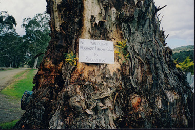
Photograph, 5 September 2004
Wooragee Landcare was formed in 1989 to promote sustainable conservation and land-use practices in the North-East region of Victoria. The organisation's work has included public awareness and education campaigns to control invasive, introduced species and protect native wildlife, such as campaigns to replant native plant species to improve soil integrity and restore habitat for flora and fauna. The organisation has drawn on the work of a variety of Government and academic experts to ensure best practice approaches are utilised. This photograph was taken at Riverview Farm, Victoria on Sunday the 5th of September as part of a day trip by the Wooragee Landcare Group. The event was about looking at land use on small farms and as a social get-together for the Group. Wooragee was also researching how small landholders could run some enterprises around the time of the trip. This photograph is a great example of the type of events that Wooragee Landcare Group has organized, while educating the public about the importance of land use management.Landscape colour photograph printed on gloss paper. Reverse: WAN NA E0NA2N2. NNN+ 4 4240/ [PRINTED] (No. 24) / 377wooragee, wooragee landcare group, wooragee landcare's collection, land use, social, riverview farm, animals, pests, indigo shire, tatong, samaria, north-east victoria -
 Kew Historical Society Inc
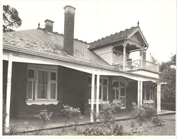
Photograph, Willsmere, circa 1965, c. 1965
The historian Dorothy Rogers records (A History of Kew, p.5) that "In 1888 he [Arthur Wills] took over his estate, 'Willsmere', and conducted it as a dairy farm. He was an architect by profession, and having established the farm he rented it, and returned to live in Barry Street, Kew, where his only child, Dorothy was born in 1889. He entered Kew Council in 1891, and three years later built a new house in Fellows Street, on land that Thomas had purchased at the 1846-47 sales. He became Mayor of Kew in 1896-97, and during his term of office sold this house and built the present 'Willsmere' [pictured] on the corner of Willsmere and Belford Roads. ... Never a house of great distinction, it has now been demolished to make way for a freeway."This work forms part of the collection assembled by the historian Dorothy Rogers, that was donated to the Kew Historical Society by her son John Rogers in 2015. The manuscripts, photographs, maps, and documents were sourced by her from both family and local collections or produced as references for her print publications. Many were directly used by Rogers in writing ‘Lovely Old Homes of Kew’ (1961) and 'A History of Kew' (1973), or the numerous articles on local history that she produced for suburban newspapers. Most of the photographs in the collection include detailed annotations in her hand. The Rogers Collection provides a comprehensive insight into the working habits of a historian in the 1960s and 1970s. Together it forms the largest privately-donated collection within the archives of the Kew Historical Society.Willsmere, the home of the Wills family of Kew, designed by the architect Arthur Wills, circa 1896. arthur wills, willsmere, belford road, willsmere road, dorothy rogers, kew, wills family -
 Eltham District Historical Society Inc
Photograph, Tess Justine (Nillumbik Shire Council), Construction work on replacement of Murray's Bridge over the Diamond Creek, Eltham North, 31 Mar 2022
Construction work on replacement of Murray's Bridge over the Diamond Creek on the Diamond Creek Trail Mary (Sweeney) Murray and John Wright Murray selected 80 acres, Lot C Section 16 and Lot 5 Section 17 Parish of Nillumbik, under an occupation license in 1866. John died in 1867 and freehold was granted to his son John in 1873. The farm was known as ‘Laurel Hill’. John Junior was an Eltham Shire councillor and sometime president from 1887 up until 1897. He added Lot A Section 16 to the farm in ca1888. John and his younger brother James arranged to rent/purchase Lot B Section 17, across Diamond Creek to the west, in ca1900. It appears that John and James farmed separately for a few years, with a new homestead built for James ad family on the high point of Lot B Section 17 in ca1910. John sold off Lot 5 Section 17 in 1912. When John died in 1912 James took over the land on both sides of the Diamond Creek. The old homestead on the west side of the Creek disappeared. A farm bridge over Diamond Creek from this period may have been located close to the northern boundary of the farm. John Langlands, owner of the farm known as ‘Ihurst’ on the west side of Diamond Creek to the south of the Murray’s land, died in 1907. In 1909 his land was then subdivided into 100 lots to become the ‘Glen Park Estate’. Other similar subdivisions of nineteenth century farms around Eltham in this period included the ‘Franktonia (or Beard’s) Estate’ to the northeast and ‘Bonsack’s Estate’ between Eltham and Greensborough. Soon after the opening of the railway extension line from Eltham to Hurstbridge in 1912, Glen Park and nearby residents including James Murray agitated for a railway station or siding to be located half-way between Eltham and Hurstbridge, so that the Glen Park residents who used the railway daily did not have to walk into the Eltham or Hurstbridge stations. Some believed Coleman’s Corner (opposite Edendale Farm) was an appropriate spot for the platform. James Murray was among those who thought the railway should be located on his land, closer to half-way between Eltham and Hurstbridge stations. The Railways Commissioners warned that the locals would have to fund these works themselves. The Glen Park Estate residents initially had difficulty accessing Eltham by road, with only an old low-level bridge over Diamond Creek at the south end of their estate. A new timber trestle bridge across the creek, now on Wattletree Road, was opened in 1915. Road access to the north was gained in 1927 when the new Murray’s Road, which crossed the Murray’s land, was built. Residents continued to agitate for a Glen Park station. By 1926 the Railways Commissioners’ preferred site was on the Murray’s land. They arranged an estimate of cost of a full-length platform. The estimate was too much for the locals, who in 1928 argued unsuccessfully for a shorter and hence cheaper platform. By 1929 Murray had agreed to donate the land, but the locals would still have to fund the works. Murray decided, unilaterally it would appear, to commence work on a timber trestle road bridge over Diamond Creek to link the new Murray Road to the proposed station. Late in 1929 he stopped work on the bridge, for reasons unknown, but started work again and completed the bridge in 1931. There is no further newspaper evidence of the campaign for the Glen Park station until 1939, when Murray and another local, Mr Maxwell, met the Railways Commissioner. The Glen Park locale now included 45 homes on the west side of the creek and 20 on the Eltham side. Most of the residents used the train every day. The Commissioner remained adamant that only a full-length platform could be built for safety reasons. It appears the campaign dissolved at this point. The increasing move to cars may have had an impact. There is no evidence of Murray’s bridge ever being connected to Murray’s Road, or of it having wide use for any purpose by locals. James Murray died in 1947 and the farm was taken over by his son James (Jim). Jim started to sell off parts of the farm in the 1980s, retaining a few acres around the ca1910 homestead and building a new house there. Recreation reserves were established along the creek. In ca1990 Murray’s bridge was renovated with steel girders as part of a bike/pedestrian path in the reserve. The old farmhouse was demolished in ca2014. Born digital image (5)diamond creek (creek), diamond creek trail, murrays bridge, ‘laurel hill’, john wright murray, mary (sweeney) murra, john murray jnr, james murray, john langlands, ‘ihurst’, ‘glen park estate’, beard's estate, franktonia, bonsack's estate, glen park estate, glen park railway station -
 Eltham District Historical Society Inc
Photograph - Digital Photograph, Jim Connor, Edendale Farm Homestead, 11 December 2014
Edendale Farm is Nillumbik Shire Council's environment centre situated in Gastons Road, Eltham between the railway and the Diamond Creek. The homestead on the property was built in 1896 and is of historical significance, being the subject of a Heritage Overlay under the Nillumbik Planning Scheme. The Edendale property was originally part of an extensive land purchase in 1852 from the Crown by pioneer Eltham farmer Henry Stooke. He initially purchased 51 acres and later expanded his holdings by purchasing another three adjacent Crown allotments extending northerly from Josiah Holloway's Little Eltham subdivision. Despite clearing the land, Stooke did not build on this property, choosing to live on his property "Rosehill" at Lower Plenty. In 1896 Thomas Cool, Club Manager of the Victoria Coffee Palace in Melbourne purchased 7 acres of the original Stooke land and built the house now known as Edendale. Cool did not farm the land, instead using it as a gentleman’s residence, retiring to Eltham at weekends. In 1918 he purchased an additional 7 acres but in 1919 he sold the property. Later owners included J.W. Cox, the Gaston family and D. Mummery. In the 1980s the Eltham Shire Council purchased the site for use as a Council depot, but this use did not proceed. Subsequently, it was used as the Council pound. The Edendale Farm Pet Education and Retention Centre was established in the summer of 1988/1989 and was set up to replace the existing dog kennels with a high standard pet retention centre. The design style of the building was established to compliment the features of the existing house. It was equipped with 10 retention pens, a veterinary room and a pet education area where school children and other interested parties learnt about pet care procedures. It was later developed into a community farm and was run by an advisory committee and in 2000 it became an Environment Centre. In early 2006 an advisory committee was established for the development of a master plan for future development at Edendale Farm. The committee included Russell Yeoman, a former long-time shire planner and founding member of the Eltham District Historical Society. At the time of filming the Master Plan and future for Edendale was about continuing to develop Edendale as a centre of environment learning and looking at expanding displays and school program, running a lot more of life-long learning and workshops around sustainable living.jim connor collection, edendale community farm, edendale farm, eltham, gastons road -
 Greensborough Historical Society
Photograph - Digital image, John McLaughlin's Eltham farm, 1934, 1934_
Part of a collection of photographs owned by Dorris McLaughlin who was born in Greensborough, in 1899 to John McLaughlin and Rosalie Ellen Whatmough. The collection contains photographs of friends and relatives from the Greensborough and Eltham areas. This photograph shows a view of John McLaughlin's Eltham farm house. The McLaughlin family never lived in this house.Digital copy of black and white photograph.dorris mclaughlin, john mclaughlin -
 Kiewa Valley Historical Society
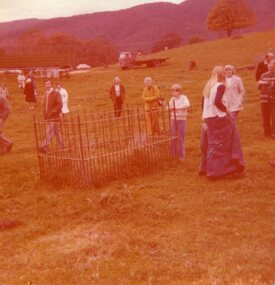
Photograph of pioneer grave, 29th May, 1977
Pictorial record of the grave of pioneer woman Mrs Mary Hollonds, who passed away in 1862. The grave is located at Mullagong Station (farm) in Tawonga, five miles south of Keegan's Bridge. Miss Hobbs, formerly of Running Creek, mentioned that twin babies of the Brigg's family are buried at Mary Holland's feet.Pictorial record of pioneer gravesites in the Kiewa Valley. Social history of people in 1977 showing interested in local historyColour photograph of group visiting the grave of pioneer woman Mrs Mary Hollands at Mullagong on 29th May, 1977Handwritten in faint blue ink on back of photograph: Mrs Mary Holland's grave. Died 1862 Mullagong. 29th May, 1977kiewa valley, mullagong station, tawonga, hollonds family, brigg's family -
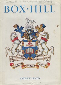 Surrey Hills Historical Society Collection
Book, Box Hill, 1978
This book looks at Box Hill as it grew from a rural backwater to a country town amid farms and orchards, then to an outer suburb, and then to an almost inner suburb. It covers the rural depression in the 1860s, the land boom of the 1880s and the collapse in the 1890s, the bitter days of two World Wars and the Depression, and the 'dry' suburb of Box Hill.Hardback book of 270 pages, indexed and footnoted, with some photos and plans; it is divided into chronological periods rather than themes."SURREY HILLS / NEIGHBOURHOOD CENTRE - HISTORY" on top of title page; "Surrey Hills Neighbourhood Centre" on top of front of jacket.box hill, dry area, temperance movement, mayors, councillors, agriculture, railways -
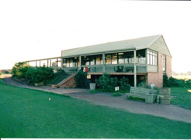 Hume City Civic Collection
Photograph, early 1980s
The series of photographs were taken shortly after the opening of the newly established Goona Warra Golf Club in the early 1980s. The golf club was part of the Goonawarra Housing Estate which was developed on the area previously known as Goonawarra Farm. The new golf club replaced 'The Pines' which was part of the Caloola complex.A coloured photograph of the front view of Goonawarra Golf Club's clubrooms. The building is on 2 levels with a large balcony across the front. Native plants have been planted around the building and a gravel path leads to the building.goona warra golf club, george evans collection -
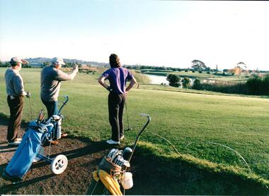 Hume City Civic Collection
Photograph, early 1980s
The series of photographs were taken shortly after the opening of the newly established Goona Warra Golf Club in the early 1980s. The golf club was part of the Goonawarra Housing Estate which was developed on the area previously known as Goonawarra Farm. The new golf club replaced 'The Pines' which was part of the Caloola complex.A coloured photograph of 3 men who are looking towards the lake at the Goonawarra Golf Club. Their golf buggies are behind them.goona warra golf club, george evans collection -
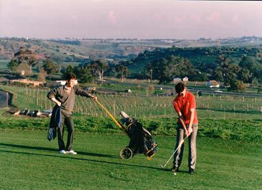 Hume City Civic Collection
Photograph, early 1980s
The series of photographs were taken shortly after the opening of the newly established Goona Warra Golf Club in the early 1980s. The golf club was part of the Goonawarra Housing Estate which was developed on the area previously known as Goonawarra Farm. The new golf club replaced 'The Pines' which was part of the Caloola complex.A coloured photograph of two golfers. One is preparing to hit off while the other is standing in the background with the golf buggy. They are standing overlooking the Goonawarra and Craiglea vineyards and the Jacksons Creek valley.goona warra golf club, george evans collection -
 Halls Gap & Grampians Historical Society
Photograph - B/W, C 1900
In early 1900, three Emmett brothers, with support from George Mason, set about following up a report of gold in the area. Confirmation of gold led to a gold rush in June 1900. Traffic from Ararat and Willaura passed Mason's Farm and it was on Mason's land that the first settlement, Ladysmith, sprang up.Road leading to Mt William goldfield 1900. George Mason's farmhouse on right hand side of road.access routes, roads, mining, ladysmith -
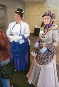 Churchill Island Heritage Farm
Photograph - Colour photograph of two women posing
Churchill Island Heritage Farm has a large photograph collection dating from the nineteenth century. This series shows the volunteers dressed in late nineteenth/early twentieth century style costumes, attending the Museums Victoria conference, held hosted by Flagstaff Hill Maritime Village and held at the Lighthouse Theatre in Warrnambool. Colour photograph of two women in period costume, standing together in group.FLAGSTAFF HILL VOL GUIDE IN/COSTUME AT MUS AUS VIC/STATE CONFERENCE 2/4/2014 [written on reverse in pen] [catalogue number on reverse in pencil]churchill island, museums victoria, flagstaff hill, warrnambool -
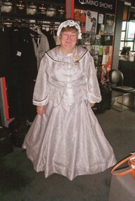 Churchill Island Heritage Farm
Photograph - Colour photograph of woman in costume
Churchill Island Heritage Farm has a large photograph collection dating from the nineteenth century. This series shows the volunteers dressed in late nineteenth/early twentieth century style costumes, attending the Museums Victoria conference, held hosted by Flagstaff Hill Maritime Village and held at the Lighthouse Theatre in Warrnambool. Colour photograph of a woman in a white period costume and mob cap, standing in front of a sign for 'Coming Shows'FRONT OF COSTUME OF FLAGSTAFF/HILL VOL GUIDE AT MUS AUS VIC/STATE CONFERENCE 2/4/14 [written on reverse in pen] [catalogue number on reverse in pencil]churchill island, museums victoria, flagstaff hill, warrnambool, photograph -
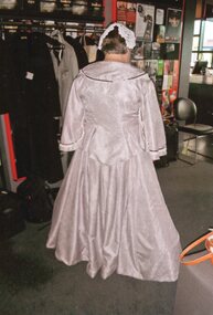 Churchill Island Heritage Farm
Photograph - Colour photograph of woman in costume
Churchill Island Heritage Farm has a large photograph collection dating from the nineteenth century. This series shows the volunteers dressed in late nineteenth/early twentieth century style costumes, attending the Museums Victoria conference, held hosted by Flagstaff Hill Maritime Village and held at the Lighthouse Theatre in Warrnambool. Colour photograph of a woman in a white period costume and mob cap. Photograph taken from back.BACK OF COSTUME OF FLAGSTAFF/HILL VOL GUIDE AT MUS AUS VIC/STATE CONFERENCE 2/4/14 [written on reverse in pen] [catalogue number on reverse in pencil]churchill island, museums victoria, flagstaff hill, warrnambool, photograph -
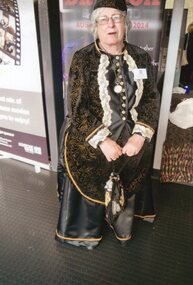 Churchill Island Heritage Farm
Photograph - Colour photograph of woman in costume
Churchill Island Heritage Farm has a large photograph collection dating from the nineteenth century. This series shows the volunteers dressed in late nineteenth/early twentieth century style costumes, attending the Museums Victoria conference, held hosted by Flagstaff Hill Maritime Village and held at the Lighthouse Theatre in Warrnambool. Colour photograph of a woman in a black period costume, carrying a small bagFRONT OF COSTUME OF FLAGSTAFF/HILL VOL GUIDE WHO MADE HER/OWN COSTUME. MUS AUS VIC/CONFERENCE 2/4/14 [written on reverse in pen] [catalogue number on reverse in pencil]churchill island, museums victoria, flagstaff hill, warrnambool, photograph -
 Churchill Island Heritage Farm
Photograph - Colour photograph of woman in costume
Churchill Island Heritage Farm has a large photograph collection dating from the nineteenth century. This series shows the volunteers dressed in late nineteenth/early twentieth century style costumes, attending the Museums Victoria conference, held hosted by Flagstaff Hill Maritime Village and held at the Lighthouse Theatre in Warrnambool. Colour photograph of a woman in a black period costume, carrying a small bag, facing to the right of frameSIDE VIEW OF BUSTLE. FLAGSTAFF/HILL VOL GUIDE AT MUS AUS VIC/CONFERENCE 2/4/14 [written on reverse in pen] [catalogue number on reverse in pencil]churchill island, museums victoria, flagstaff hill, warrnambool, photograph -
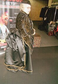
 Churchill Island Heritage Farm
Photograph - Colour photograph of woman in costume
Churchill Island Heritage Farm has a large photograph collection dating from the nineteenth century. This series shows the volunteers dressed in late nineteenth/early twentieth century style costumes, attending the Museums Victoria conference, held hosted by Flagstaff Hill Maritime Village and held at the Lighthouse Theatre in Warrnambool. Colour photograph of a woman in a black period costume, carrying a small bag and facing away from the camera.BACK OF COSTUME. BEADED BLACK/VELVET COST $30P/M!/FLAGSTAFF HILL VOL GUIDE AT/MUS AUS VIC CONFERENCE/2/4/2014 [written on reverse in pen] [catalogue number on reverse in pencil]churchill island, museums victoria, flagstaff hill, warrnambool, photograph -
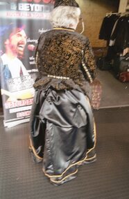
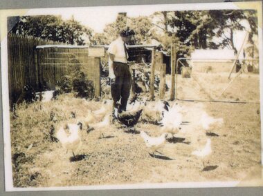 Churchill Island Heritage Farm
Photograph - Photograph of a woman and chickens
Churchill Island Heritage Farm has a large photographic collection dating from the nineteenth century. This series showcases photographs taken in the 1930s and 1940s and shows people who lived and worked on the Island during the Jenkins period. This photograph was taken in December 1939 and shows Ted Jenkins' carer, Margaret Campbell.Sepia photograph white narrow white border of a woman standing among a flock of white chickens, with a fence and gate visible in the background. Digitised from a high resolution copy (original Polaroid is in poor and fragile condition)nilchurchill island, photograph, arthur evans, margaret campbell -
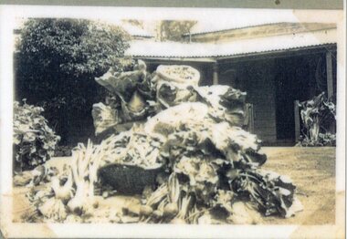 Churchill Island Heritage Farm
Photograph - Photograph of pile of vegetables
Churchill Island Heritage Farm has a large photographic collection dating from the nineteenth century. This series showcases photographs taken in the 1930s and 1940s and shows people who lived and worked on the Island during the Jenkins period. This photograph shows the harvest from Churchill Island taken from the vegetable gardenSepia photograph of a large mound of vegetables in front of Rogers Cottages. Digitised from a high resolution copy (original Polaroid is in poor and fragile condition)nilchurchill island, photograph, arthur evans, vegetable -
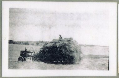 Churchill Island Heritage Farm
Photograph - Photograph of hay on tractor
Churchill Island Heritage Farm has a large photographic collection dating from the nineteenth century. This series showcases photographs taken in the 1930s and 1940s and shows people who lived and worked on the Island during the Jenkins period. This photograph provides an insight into some of the farming work that took place on Churchill Island.Black and white photograph with white border of a small tractor pulling a wagon loaded with a large pile of hay. A man in a hat sits on the top of the hay, and the tractor is stationary in a large paddock. Digitised from a high resolution copy (original Polaroid is in poor and fragile condition)nilchurchill island, photograph, arthur evans, hay, tractor -
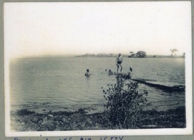 Churchill Island Heritage Farm
Photograph - Photograph of people swimming in the water
Churchill Island Heritage Farm has a large photographic collection dating from the nineteenth century. This series showcases photographs taken in the 1930s and 1940s and shows people who lived and worked on the Island during the Jenkins period. This photograph shows three people swimming off the old jetty on Churchill Island.Black and white photograph of three people: one standing on a jetty, and two in the water. Taken from the shoreline with a small bush in the foreground, and treeline visible in the background. Digitised from a high resolution copy (original Polaroid is in poor and fragile condition)nilchurchill island, photograph, arthur evans, swimming -
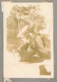 Churchill Island Heritage Farm
Photograph - Photograph of man and dog
Churchill Island Heritage Farm has a large photographic collection dating from the nineteenth century. This series showcases photographs taken in the 1930s and 1940s and shows people who lived and worked on the Island during the Jenkins period. This photograph shows Ted Jenkins - the son of the owner of Churchill Island, Harry Jenkins.Sepia photograph with white border showing a man in a wheelchair leaning over to pat a black and white dog sitting in a bucket. Digitised from a high resolution copy (original Polaroid is in poor and fragile condition)nilchurchill island, photograph, arthur evans, ted jenkins -
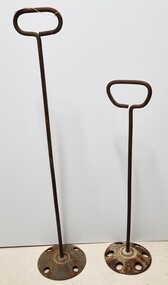 Wodonga & District Historical Society Inc
Functional object - Cream Stirrers, 1940s
These stirring rods with long handles and base referred to as a dasher were common in the dairy industry. They were made to agitate milk or cream in milk cans and were used on dairy farms and in old creameries. They helped to cool the milk and stop it from separating. They were used on the properties of the Conway and Lemke families in Wodonga.These items are significant as they are representative of tools used in the early dairy industry and were owned by families in Wodonga.Milk / cream stirrers made from steel with a circular blade attached to enable milk to flow through.dairy industry wodonga, dairy tools, dairy machinery -
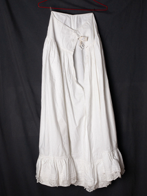 City of Moorabbin Historical Society (Operating the Box Cottage Museum)
Clothing, Lady's white, long, half petticoat cotton c1900, c1900C
A Lady's white, long, cotton half petticoat with a gathered flounce and lace insert at hem. The petticoat has a placket on the side seam and is fastened with bone buttons, The pioneer families had to be self sufficient making their own tools, clothing, while developing their market gardens, fruit orchards and dairy farms in Moorabbin Shire The pioneer women in Moorabbin Shire had to make and repair the clothes for themselves and their families and were accomplished in dressmaking, needlework , craftwork and knitting A Lady's white, long, cotton half petticoat with a wide flounce lace edging and bone buttons at side seam clothing, brighton, moorabbin, pioneers, dressmaking, market gardeners, early settlers, craftwork , bentleigh, lacework, moorabbin shire blackburn nance, dairy farms, fruit orchards -
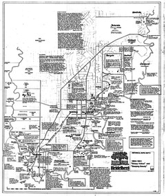 Greensborough Historical Society
Map, Heidelberg: Historic River Landscape Assessment. Historical maps. Map D 1864 -1901 "Sleepy Hollow" and "Sleeping beauty", 1985c
Geographical area of c. 35 sq. kilometres marked with physical features such as major roads, rivers, vegetation and properties, with locations and notes on the increasing number of farms, orchards and vineyards that had been developed in addition to pastoral runs. Bounded by Shire of Diamond Valley to the North, Darebin Creek to the West, and Plenty River to the East.Black and white sketch on white paper. Second copy 600 x 430 cm printed in black on semi-opaque paperheidelberg, heidelberg - maps -
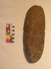 Bunjil Park Aboriginal Education & Cultural Centre
stone axehead
This stone was held by a European family for 200 years and was found on the family farm. It was gifted to Uncle Brien Nelson in Castlemaine. This implement could be many thousands of years old. This unusually large axe head would not have been carried from place to place and was probably hidden for occasional use crafting large objects.This stone axe head is shaped to a sharpened rounded edge at one end and is broad and blunt at the other end. It is an elongated teardrop shape in cross section. It has a distinctive waist in the middle where the haft was attached using hide and or fibre.This axe displays grooves caused by a disk plough.jaara, heavy stone axe head -
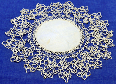 Orbost & District Historical Society
doily, late 19th -early 20th century
This doily was handmade by Penuel Cameron (nee Hossack). The Hossack family farmed land on the Marlo Road. Like the Camerons they were staunch Presbyterians. Robert Cameron was one of earliest settlers on Orbost flats and ran the paddlesteamer "Cheviot". He served many years on shire council and built the first Presbyterian. church in Orbost.This item is an example of a handcrafted item and reflects the needlework skills of women in the families of the early settlers.Hand tatted medium sized doily. Small round linen piece in centre and large tatted border.doily handcrafts needlework linen lace cameron-robert -
 Tatura Irrigation & Wartime Camps Museum
Photograph, Presbyterian Boys
Photos copied from Superintendent Hannan's album. Presbyterian Boys Training Farm. Dhurringile Mansion. 7 Photos. Pipe Band c.1955. Jock Lawrie, Pipe Major. Photo2- Adam Katinis, top left; Jim Brown right. Photo 4- Left Nigel Stewart; Right Les Ferguson.photograph, people, presbyterian boys training farm, dhurringile mansion, pipe band, jock lawrie, adam katinis, jim brown, nigel stewart, les ferguson -
Churchill Island Heritage Farm
Photograph of a shoreline on Churchill Island, Unknown
Churchill Island Heritage Farm has a large photograph collection dating from the mid-nineteenth century to the last decade. This series of photographs show events and people from the Churchill Island precinct and the enormous amount of collaboration and work that went into the development of the heritage area and making it accessible and interactive for visitors of all ages.Black and white photograph of the shoreline on Churchill Island. Photograph has been printed on a type of card and has a matte finish applied.Catalogue number written in pencil on reverse.churchill island, photograph, cannon -
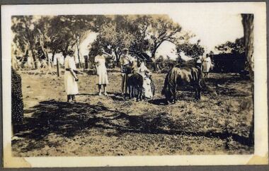 Churchill Island Heritage Farm
Photograph - Photograph of group of people
Churchill Island Heritage Farm has a large photographic collection dating from the nineteenth century. This series showcases photographs taken in the 1930s and 1940s and shows people who lived and worked on the Island during the Jenkins period. This photograph was taken in January 1940 and shows the son of the owner of Churchill Island, Ted Jenkins.Sepia photograph white narrow white border of a group of four women wearing white dresses standing in a pasture with a horse, a man in a wheelchair in front of a group of trees. Digitised from a high resolution copy (original Polaroid is in poor and fragile condition)nilchurchill island, photograph, arthur evans, ted jenkins