Showing 4792 items
matching heritage properties
-
 Kew Historical Society Inc
Archive (Sub-series) - Subject File, Kew Court House 1986-1989, 1986
... announced its intention to sell the properties comprising ...Various partiesReference, Research, InformationSecondary Values (KHS Imposed Order)Subject file containing information relating to the Kew Post Office complex, including the Kew Court House and the Police Station. The correspondence between parties included the City of Kew, the Kew Historical Society, and the Victorian Government. Initially the correspondence related to the proposed use of the Court House as a Centre for the Society as it was being forced to vacate the Copy Shop (q.v) in Walpole Street due to its impending demolition. Later correspondence relates to the proposed sale of the Court House by the Victorian Government.kew - history, kew court house, kew police station, heritage campaigns - kew (vic)kew - history, kew court house, kew police station, heritage campaigns - kew (vic) -
Kew Historical Society Inc
Archive (Sub-series) - Subject File, Kew Court House - 2000-2005, 2000
... announced its intention to sell the properties comprising ...Various partiesReference, Research, InformationSecondary Values (KHS Imposed Order)Subject file containing information about the heritage significance of the Kew Court House (and Police Station) in High Street, Kew. Most of the file contains correspondence between a number of interested parties including the Kew Historical Society which was leading the campaign to have the building/precinct preserved and used for community purposes. Letters and submissions include those from the Department of Treasury & Finance, Ray Tonkin (Heritage Victoria), Dr. Robert Dean MLA, Judith Voce, Hon David Davis MLC, John Lenders MP, Hon John Thwaites, Andrew McIntosh MLA and officers of the Kew Historical Society. The file also contains records of interview and memos and meeting minutes relating to the campaign.kew - history, kew court house, kew police station, heritage campaigns - kew (vic)kew - history, kew court house, kew police station, heritage campaigns - kew (vic) -
 Kew Historical Society Inc
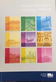
Booklet, Heritage Victoria, Victoria Framework of Historical Themes, 2010
... cultural property -- victoria heritage -- victoria history ...Guidelines for administering the Victorian Framework of historical themes75 p. : ill. ; 30 cmnon-fictionGuidelines for administering the Victorian Framework of historical themescultural property -- victoria, heritage -- victoria, history -- themes -
 Kew Historical Society Inc
Photograph - Lalla Rookh : 41 Fellows Street, Progress Press, 1978
The National Trust (Victoria) citation on the Heritage Victoria Database describes Lalla Rookh as charming and rare example of a substantial domestic building from the depths of the depression of the 1890s. It was Classified by the Trust on 22/04/1971. The first Kew Urban Conservation Study established that the house was built in 1897 for John Duncan, civil servant. By 1910 William Robert Frayne, chemist, had purchased the property. When the building was listed by the National Estate the building was described as: '... Single-storied, the symmetrical, stuccoed house features a central porch with an arched opening and pedimented consoles and a bull-nose verandah which returns down both sides and is constructed with cast iron columns and friezes. A balustraded parapet crowns the main walls of the house. The encaustic tiled verandah is distinctive.'"Lalla Rookh", 41 Fellows Street, Kew, is of architectural interest as a representative example of a villa house of the period and also forms pan of the townscape of Kew. In a late version of Boom Style Classicism, the basically modest and conventionally planned house is proportioned to emphasise the porch and heavy balustrade, contrasting with the verandah and plain wall surfaces. The parapet may have had urns originally. The encaustic tiled verandah is of note. ... Of local significance.'Photographic print positive of the facade of Lalla Rookh at 41 Fellows Street, Kew.lalla rookh, houses -- fellows street -- kew (vic.), boom style architecture, architecture -- melbourne -- 1890s -
Kew Historical Society Inc
Journal, Kewriosity : May 1989
Canadian visitors to Wallenberg Garden / p1. Bringing up kids in the nineties / p1. Dates for May / p2. Useful advice on Property Numbering / p2. Kew Living 1988 / p2. Commentary [Kew Conservation Study] / Cr Allen Marshall p3. Kew Conservation Study / p3. Heritage advice for local homeowners / p3. Why we should think again [Kew Conservation Study] / Keith Lodge p4. Books for sale [Friends of Kew Library] / p4. 1629 on the AM Band / p4. [Kew] Festival meeting / p5. Community health visit to Kew / p5. Craig will keep the wheels turning [Meals on Wheels] / p5. New Co-ordinator for People with Disabilities [Jan Bottcher] / p5. Canterbury move for Care-Force [Care-Force Inner East] / p5. CWA not just for country women / p5. Notices / p5. Kew Community House / Judy Price p6. A welcome haven [Kew Community House] / p6. Second chance at reading and writing [adult literacy] / p6. A place where young people can feel at home [Kew Youth Resource Centre] / p7. Music for children / p7. CALM speaker for Kew [Citizens’ Against Lawlessness Movement] / p7. New courses focus on business skills / p7. A letter to the editor / Charles Ng p7. Small group support for family caregivers / p7. Footy News [Kew Football Club] / p8. Kew's "Eagles" need caretaker [Kew Eagles Soccer Club] / p8. Not just for the boys [Hays Paddock Junior Football Clinic] / p8. Keeping you informed [Citizens Advice Bureau] / p8.Kewriosity was a local newsletter combining Kew Council and community news. It was published between November 1983 and June 1994, replacing an earlier Kewriosity [broad] Sheet (1979-84). In producing Kewriosity, Council aimed to provide a range of interesting and informative articles covering its deliberations and decision making, together with items of general interest and importance to the Kew community and information not generally available through daily media outlets.non-fictionCanadian visitors to Wallenberg Garden / p1. Bringing up kids in the nineties / p1. Dates for May / p2. Useful advice on Property Numbering / p2. Kew Living 1988 / p2. Commentary [Kew Conservation Study] / Cr Allen Marshall p3. Kew Conservation Study / p3. Heritage advice for local homeowners / p3. Why we should think again [Kew Conservation Study] / Keith Lodge p4. Books for sale [Friends of Kew Library] / p4. 1629 on the AM Band / p4. [Kew] Festival meeting / p5. Community health visit to Kew / p5. Craig will keep the wheels turning [Meals on Wheels] / p5. New Co-ordinator for People with Disabilities [Jan Bottcher] / p5. Canterbury move for Care-Force [Care-Force Inner East] / p5. CWA not just for country women / p5. Notices / p5. Kew Community House / Judy Price p6. A welcome haven [Kew Community House] / p6. Second chance at reading and writing [adult literacy] / p6. A place where young people can feel at home [Kew Youth Resource Centre] / p7. Music for children / p7. CALM speaker for Kew [Citizens’ Against Lawlessness Movement] / p7. New courses focus on business skills / p7. A letter to the editor / Charles Ng p7. Small group support for family caregivers / p7. Footy News [Kew Football Club] / p8. Kew's "Eagles" need caretaker [Kew Eagles Soccer Club] / p8. Not just for the boys [Hays Paddock Junior Football Clinic] / p8. Keeping you informed [Citizens Advice Bureau] / p8. publications -- city of kew (vic.), kewriosity, council newsletters, community newsletters -
 Kew Historical Society Inc
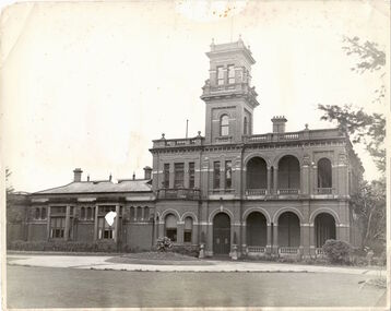
Photograph - 'Raheen', Studley Park Road (Kew), c.1965
"The first section of Raheen was commenced in 1870 with an extension added in 1884. It was designed by William Salway and built for Edward Latham of the Carlton Brewery. Sir Henry Wrixon, prominent Melbourne barrister and solicitor, later owned and resided at the property. In 1917 Raheen was purchased by the Catholic Church and became the official residence of Archbishop Mannix, as well as four other Catholic archbishops of Melbourne. In 1981 the Church sold the property and it again reverted to a private residence." (Victorian Heritage Database, 2023)This work forms part of the collection assembled by the historian Dorothy Rogers (1905-1973), donated to the Kew Historical Society by her son in 2015. The manuscripts, photographs, maps, and documents were sourced by her from both family and local collections or produced as references for her print publications. Many were directly used by Rogers in writing ‘Lovely Old Homes of Kew’ (1961) and 'A History of Kew' (1973), or the numerous articles on local history that she produced for suburban newspapers. Most of the photographs in the collection include detailed annotations in her hand. The Rogers Collection provides a comprehensive insight into the working habits of a historian from the 1960s to the 1970s. Original, monochrome print copy of a photograph of Raheen in Studley Park Road (Kew). The unrendered red brick house with tower has a toe story section at right with a double colonnade and a single story section at left. The photographs predates the restoration of the gardens and house by te. Pratt family. Annotation verso: "Raheen. R. C. Archbishops Palace, Studley Park Road, Kew".reheen, mansions -- kew (vic.), studley park road -
 Kew Historical Society Inc
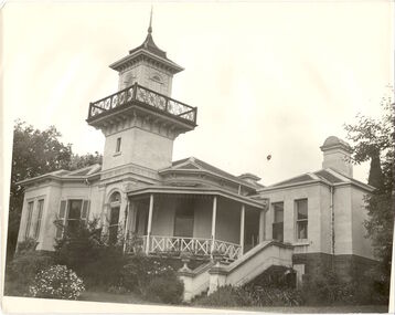
Photograph, J E & B L Rogers, 'Swinton', Swinton Avenue, c.1960
'The land on which 'Swinton'was later built was first purchased by John Bakewell in 1851 and later sold to Edmund Laskey Splatt in 1858. Splatt was a member of the first provisional committee of the National Bank of Australia in Melbourne and built the first house on the land naming it 'Laskey Villa'. By 1863 the house was occupied by Herbert Henty. The Johnson family connection with the property began with the marriage in 1858 of Annabella Johnson to David Syme, owner of the Áge' newspaper and owner of the adjacent property 'Blytheswood'. Annabella's brother, Francis Johnson, bought the villa in 1876 and renamed it 'Swinton' after his birthplace in Yorkshire. The property was later owned by the artistic Colquhoun family. The house is one of the earliest examples of the Italianate style in Victoria - the outstanding element being the tower with its cantilevered walkway and heavily bracketed pryamidal tower.' Source: Victorian Heritage RegisterThis work forms part of the collection assembled by the historian Dorothy Rogers, that was donated to the Kew Historical Society by her son John Rogers in 2015. The manuscripts, photographs, maps, and documents were sourced by her from both family and local collections or produced as references for her print publications. Many were directly used by Rogers in writing ‘Lovely Old Homes of Kew’ (1961) and 'A History of Kew' (1973), or the numerous articles on local history that she produced for suburban newspapers. Most of the photographs in the collection include detailed annotations in her hand. The Rogers Collection provides a comprehensive insight into the working habits of a historian in the 1960s and 1970s. Together it forms the largest privately-donated collection within the archives of the Kew Historical SocietySwinton in Kew and its tower. This side of the house faces the Yarra River.swinton, laskey villa, swinton avenue, kew, dorothy rogers -
 Kew Historical Society Inc
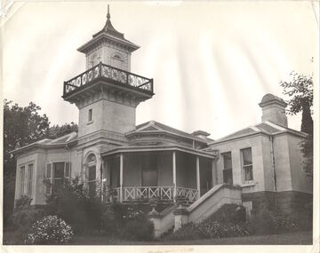
Photograph, J E & B L Rogers, 'Swinton', Swinton Avenue, c.1960
This work forms part of the collection assembled by the historian Dorothy Rogers, that was donated to the Kew Historical Society by her son John Rogers in 2015. The manuscripts, photographs, maps, and documents were sourced by her from both family and local collections or produced as references for her print publications. Many were directly used by Rogers in writing ‘Lovely Old Homes of Kew’ (1961) and 'A History of Kew' (1973), or the numerous articles on local history that she produced for suburban newspapers. Most of the photographs in the collection include detailed annotations in her hand. The Rogers Collection provides a comprehensive insight into the working habits of a historian in the 1960s and 1970s. Together it forms the largest privately-donated collection within the archives of the Kew Historical Society."The land on which Swinton was later built was first purchased by John Bakewell in 1851 and later sold to Edmund Laskey Splatt in 1858. Splatt was a member of the first provisional committee of the National Bank of Australia in Melbourne and built the first house on the land naming it Laskey Villa. By 1863 the house was occupied by Herbert Henty. The Johnson family connection with the property began with the marriage in 1858 of Annabella Johnson to David Sym - owner of The Age newspaper and owner of the adjacent property Blytheswood. Annabella's brother, Francis Johnson, bought the villa in 1876 and renamed it Swinton after his birthplace in Yorkshire. The property was later owned by the artistic Colquhoun family. The house is one of the earliest examples of the Italianate style in Victoria - the outstanding element being the tower with its cantilevered walkway and heavily bracketed pyramidal tower. (Source: Victorian Heritage Database)"Swinton. Built about 1959-60. Chap.20 Swinton. Johnson - Col"swinton, swinton avenue (kew) -
 Kew Historical Society Inc
Plan - Subdivision Plan, Shop Sites, East Kew, c.1927
Subdivision plans are historically important documents used as evidence of the growth of suburbs in Australia. They frequently provide information about when the land was sold on which a built structure was subsequently constructed as well as evidence relating to surveyors and real estate and financial agents. The numerous subdivision plans in the Kew Historical Society's collection represent working documents, ranging from the initial sketches made in planning a subdivision to printed plans on which auctioneers or agents listed the prices for which individual lots were sold. In a number of cases, the reverse of a subdivision plan in the collection includes a photograph of a house that was also for sale by the agent. These photographs provide significant heritage information relating house design and decoration, fencing and household gardens.This is one of a small number of subdivision plans for commercial property in the collection. The subdivision proposed to create six shop sites in High Street between the Harp of Erin and Station Street. The plan shows this stretch of High Street, East Kew already lined with shops that include the hotel on the corner, the new State Savings Bank, a dentist’s surgery and Lambert’s Store. The High Street Tram was to reach Burke Road in 1925, so the proposed subdivision must postdate that event, and the opening of the Bank in 1926.subdivision plans - east kew, high street - east kew -
 Kew Historical Society Inc
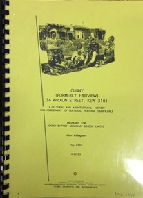
Document, Allan Willingham, Cluny (Formerly Fairview) 34 Wrixon Street, Kew 3101: A cultural and architectural history and assessment of cultural heritage significance / Allan Willingham, 2006
Research Report on Fairview, Cluny, held in the KHS Reference Files. Research report, prepared by Allan Willingham for Carey Baptist Grammar School in 2006, into Cluny (formerly Fairview) 34 Wrixon Street, Kew 3101. The cultural and architectural history and assessment of cultural heritage includes a summary of the building's current heritage status, a history of the property, biographical portraits of the principal owners, an architectural history, an assessment of its cultural heritage significance, a statement of conservation policy and appendices.fairview -- wrixon avenue -- kew (vic.) -
 Kew Historical Society Inc
Album - Photographs of heritage sites in Victoria, Eva Grant, 1964-66
... of John Furlonge 1835. Important record of significant heritage ...Eva Grant was a member of the Kew Historical Society. Three albums in the collection were created by her, this one, the third created between 1964 and 1966. They were donated to the Society by her daughter in 2010. Each of the albums includes photographs and newspaper cuttings collected on her travels to historic places in South East Australia in the 1950s and 1960s. Particular structures photographed in this album include: Barnawatha (Vic.) - The Hermitage | Beveridge (Vic.) - Stone cottage where Ned Kelly was born. | Brighton - St Andrew’s Church graveyard. | Chiltern (Vic.) - lake view [missing] | Cowes (Vic.) - ‘Broadwater’ [originally home of Henty-Wilson family], demolished 1965; Bell of the Speke wreck; Edward’s tree. | Euroa (Vic.) - Habbies Howe | Fairfield (Vic.) - Dight’s Falls; John Dight. | Fernshawe (Vic.) - Queen Mary tree. | Jolimont (Vic.) - Old railway tunnel linking the first Government House (1964); Sign identifying location of first Government House. | Kew (Vic.) - Cairn at Dight’s Falls; Canoe tree, Bowyer Avenue. | Kyneton - De Grave’s Flour Mill - “C”. | Maldon (Vic.) - Chinese oven; Macarthur’s House; Maldon’s oldest resident; Chinese graves x 2; [Beehive Chimney]. | Marysville (Vic.) - Centenary cairn | Mitcham (Vic.), Mud brick house x 2, Deep Creek Road. | Melbourne (Vic.) - St Paul’s Cathedral [renovation] (1964); Wreckers at Damman’s Corner, cnr Bourke and Collins Streets (1964); Princess Gate project x 2 (1964); Colonial Storekeeper’s building on cnr King and Bourke Streets (1966); Early observatory 1861-3; the Honey Memorial. | Mt Oberon (Vic.) - [obsolete] radio telephone dish. | Seymour (Vic.) - Habres (sic) House x 3.| Swan Hill (Vic.) - Major Mitchell’s Cairn (12/1964); Headstone of Andrew Beverage AM (12/1964). | Templestowe (Vic.) - Finn’s Hotel. | Thornton (Vic.) - Eildon Station. | Werribee (Vic.) - Chirnside Memorial [Presbyterian] Church; gaslight beside church | Location unknown, but possibly Swan Hill - Brick house; Wooden bullock dray. | Location unknown - Headstone of John Furlonge 1835.Important record of significant heritage properties in Victoria, many of which have since been demolished.30 page spirex bound drawing book including photographs and newspaper articles of historic buildings in Victoria. The front cover has a picture of a steam boat. The cover is encased in plastic. A number items in the album are annotated with written commentary by Eva Grant who compiled the album. Annotations and transcriptions by Eva Grant on most imageseva grant, photograph albums, heritage places - victoria -
 Kew Historical Society Inc
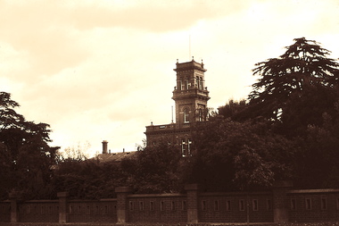
Slide - 'Raheen', Studley Park Road, 1976
Colour transparency (slide) created in June 1976 during a tour by the Junior National Trust, which was led by members of Kew Historical Society. The collection of 21 slides reveals that the tour covered all parts of Kew, but focused understandably on heritage buildings and sites.Image of an historic place in Kew that can be dated to an exact time and place. The images, albeit amateurish in composition, frequently reveal aspects of important buildings and sites that have changed over time.35mm colour transparency of Raheen in Studley Park Road, Kew in 1976. The building of the house commenced in 1870, while major additions were made in 1884. The view is of the fence and tower. Presumably the photograph was taken from Studley Park Road. The property was still during this period the palace of the Catholic Archbishop of Melbourne. The colour of the slide has degraded over time. historic houses -- kew (vic.), raheen -- studley park road -- kew (vic.) -
 Kew Historical Society Inc
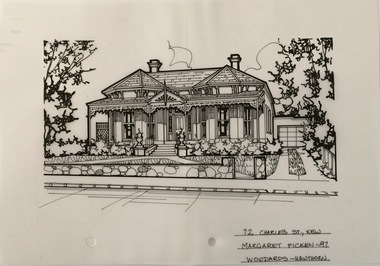
Drawing - Property Illustration, Margaret Picken, 72 Charles Street, Kew, 1997
After training as a Cartographic Draftsman within the mining industry, I worked as a property illustrator for real estate firms in the eastern suburbs of Melbourne for 23 years from 1983. I initially photographed houses with a Polaroid camera and made a 'thumbnail' sketch while there. The photos were used to scale off a sketch in pencil and then that sketch was overlaid with drafting film and the 'pen and ink' completed. The pens I used were the Rotring ‘Rapidigraph’ drafting pens. The ink was also made by Rotring (German).The film was ‘Rapidraw’, polyester drafting film, double matte. It takes a very fine line and doesn’t bleed. As well as house sketches, there were often floor plans and site plans ordered. Aerial sketches were ordered when the property needed an overall view. (Margaret Picken, 2020)This drawing is one of a series created by Margaret Picken for a range of real estate agents in Melbourne between c.1983 and c.2005. Each work is signed and dated by the artist.Gift of Margaret Picken, 2020Victorian villa of Hawthorn brick. Built in 1890 and with Grade B heritage listing by the City of Boroondara. Rear additions and alterations in 1999. Replacement verandah roof and floor in 2020. Stone fence has been replaced with a palisade fence. The pen and ink architectural drawing on drafting film of 72 Charles Street, Kew was made by Margaret Picken in 1997.72 CHARLES ST., KEW / MARGARET PICKEN ~97 / WOODARDS ~ HAWTHORNartist -- margaret picken 1950-, architectural drawings -- houses -- kew (vic.), 72 charles street -- kew (vic.) -
 Kew Historical Society Inc
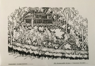
Drawing - Property Illustration, Margaret Picken, 82 Molesworth Street, Kew, 2001
After training as a Cartographic Draftsman within the mining industry, I worked as a property illustrator for real estate firms in the eastern suburbs of Melbourne for 22 years from 1983. I initially photographed houses with a Polaroid camera and made a 'thumbnail' sketch while there. The photos were used to scale off a sketch in pencil and then that sketch was overlaid with drafting film and the 'pen and ink' completed. The pens I used were the Rotring ‘Rapidigraph’ drafting pens. The ink was also made by Rotring (German).The film was ‘Rapidraw’, polyester drafting film, double matte. It takes a very fine line and doesn’t bleed. As well as house sketches, there were often floor plans and site plans ordered. Aerial sketches were ordered when the property needed an overall view. (Margaret Picken, 2020)The R Haughton James House (former) was built to a design by Robin Boyd in 1956-57. With its unusual plan form, this is one of Robin Boyd’s most important residential commissions of the period. The house was identified in heritage study as being of architectural significance at the state level. Alterations to the house were made in 1967, 1989, and 1999. This drawing is one of a series created by Margaret Picken for a number of real estate agents in Melbourne between 1983 and 2005. Each work is signed and dated by the artist.Gift of Margaret Picken, 2020Pen and ink architectural drawing on drafting film of 82 Molesworth Street, Kew by Margaret Picken.MARGARET PICKEN © 2001 / 82 MOLESWORTH ST, KEW ~ HOCKING STUARTartist -- margaret picken 1950-, architectural drawings -- houses -- kew (vic.), 82 molesworth street - kew (vic) -
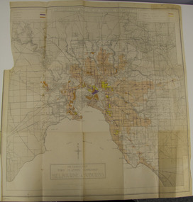 Glen Eira City Council History and Heritage Collection
Map - Map, zoning, Metropolitan Town Planning Commission, "DISTRIBUTION AND USE OF EXISTING PROPERTY. MAP NO. 6.", 1929
The map titled: “Distribution and use of Existing property map No. 6” (Metropolitan Town Planning Commission Melbourne and Suburbs) is of historical significance. It is listed on page 168 of Chapter 4 the Zoning section of the "Plan of General Development Melbourne Report of the Metropolitan Town Planning Commission 1929" - Melbourne's first strategic plan. Map No. 6 is mentioned throughout Chapter 4 of the 1929 Report. It states on page 156 that this Map was created to graphically illustrate the data collected by the Planning Commission. The Map illustrates the general distribution of uses of existing property throughout the metropolitan area. The coloured sections show the areas which were developed or were in the process of development in 1929. The colours indicate the distribution of uses in the developed areas. The pink coloured areas, which include Caulfield, were almost completely residential.1929, metropolitan town planning commission, melbourne, suburbs -
 Glen Eira City Council History and Heritage Collection
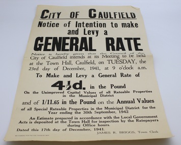
Flyer, The Craftsman Press Pty. Ltd, 1941
This flyer is entitled "City of Caulfield / Notice of Intention to make and Levy a General Rate" and served to notify residents that the Council of the City of Caulfield intended to "make and levy a General Rate of four and a half pence in the pound on the unimproved Capital Values of all Rateable Properties in the Municipal District and of 1/11.65 in the pound on the Annual Values of all Special Rateable Properties in the Municipal District for the Year ending the 30th September, 1942" at its meeting to be held at the Town Hall of Caulfield on Tuesday 23rd of December, 1941. The flyer bears the name of the Town Clerk, James R. Briggs. The flyer was printed by The Craftsmen Press for City of Caulfield, and is dated 17th December, 1941.Single page flyer printed on buff paper with black ink. Entitled "City of Caulfield / Notice of Intention to make and Levy a General Rate" -
 Glen Eira City Council History and Heritage Collection
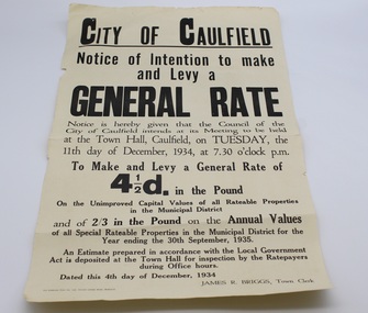
Flyer, 1934
This flyer is entitled "City of Caulfield / Notice of Intention to make and Levy a General Rate" and served to notify residents that the Council of the City of Caulfield intended to "make and levy a General Rate of four and a half pence in the pound on the unimproved Capital Values of all Rateable Properties in the Municipal District and of 2/3 in the pound on the Annual Values of all Special Rateable Properties in the Municipal District for the Year ending the 30th September, 1935" at its meeting to be held at the Town Hall of Caulfield on Tuesday 11th of December, 1934. The flyer bears the name of the Town Clerk, James R. Briggs. The flyer was printed by The Craftsmen Press for City of Caulfield, and is dated 4th December, 1934.Single page flyer printed on buff paper with black ink. Entitled "City of Caulfield / Notice of Intention to make and Levy a General Rate" -
Surrey Hills Historical Society Collection
Archive - Vertical file, Armitstead family
The Armitstead family's first woodyard in Surrey Hills was located in Croydon Road but later they moved to 153-157 Union Road, Surrey Hills. The business delivered timber and briquettes for heating to homes in the local area but also blocks of ice in the days before refrigerators were a usual household appliance. The timber was unloaded from railway trucks at a siding at Surrey Hills station; some came from the Armitstead's property of 130 acres of timbered land near Killara. They also sold mallee roots and briquettes.A vertical file containing the following documents: 1. Land Victoria map of Surrey Hills including Union Road from Bedford Street to Montrose Street, showing location of woodyard (undated) (1 A3 page). 2. Possibly ‘Sun’ article ‘When Surrey Hills ran short of wood’, Michael Sefton (undated) (1 page). 3. Plaque for the red mechanism of the weighbridge at Centre, by convenor, Surrey Hills Heritage Group, 12.11.2002 (1 page). 4. Pooley and Sons weighbridge, notes by Dennis Armstrong, in email to Sue Barnett, 4.4.2013 (2 pages). 5. Laminated diagram and notes by Ken Hall re weighbridge from Armitstead’s woodyard, and photocopy, undated (3 pages). 6. ‘Armitstead’s woodyard’ 153-7 Union Road (now Neighbourhood Centre), typed Progress Leader article, 13.1.1982 (2 pages). pooley and sons weighbridge, armitstead family, woodyard, armitstead's woodyard, union road -
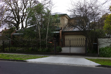
 Surrey Hills Historical Society Collection
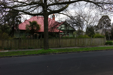
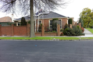
Photograph - 2 Weybridge Street, Surrey Hills, On The Street Where You Live Project
... risk were properties not covered by heritage overlays ...Photos documenting this address as part of a photographic series undertaken by volunteer photographers during 2013 and 2014 for The Street Where You Live Project. This was organised through the Surrey Hills Neighbourhood Centre and covered the postcode 3127 in the cities of Boroondara and Whitehorse.These photos provide a snapshot of real estate in the suburbs of Mont Albert and Surrey Hills during a period of rapid change with many properties on large blocks demolished to create higher density residential development or renewal of single dwellings. At particular risk were properties not covered by heritage overlays, especially interwar housing and post 1950's housing. -
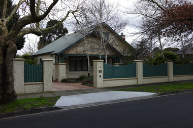
 Surrey Hills Historical Society Collection
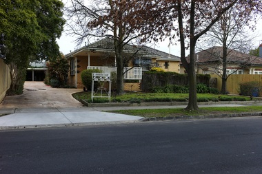
Photograph - 2A Weybridge Street, Surrey Hills, On The Street Where You Live Project
... risk were properties not covered by heritage overlays ...Photos documenting this address as part of a photographic series undertaken by volunteer photographers during 2013 and 2014 for The Street Where You Live Project. This was organised through the Surrey Hills Neighbourhood Centre and covered the postcode 3127 in the cities of Boroondara and Whitehorse.These photos provide a snapshot of real estate in the suburbs of Mont Albert and Surrey Hills during a period of rapid change with many properties on large blocks demolished to create higher density residential development or renewal of single dwellings. At particular risk were properties not covered by heritage overlays, especially interwar housing and post 1950's housing. -
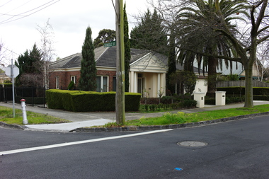
 Surrey Hills Historical Society Collection
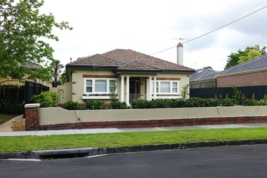
Photograph - 3 Weybridge Street, Surrey Hills, On The Street Where You Live Project
... risk were properties not covered by heritage overlays ...Photos documenting this address as part of a photographic series undertaken by volunteer photographers during 2013 and 2014 for The Street Where You Live Project. This was organised through the Surrey Hills Neighbourhood Centre and covered the postcode 3127 in the cities of Boroondara and Whitehorse.These photos provide a snapshot of real estate in the suburbs of Mont Albert and Surrey Hills during a period of rapid change with many properties on large blocks demolished to create higher density residential development or renewal of single dwellings. At particular risk were properties not covered by heritage overlays, especially interwar housing and post 1950's housing. -
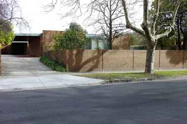
 Surrey Hills Historical Society Collection
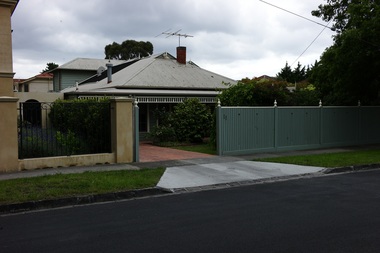
Photograph - 4 Weybridge Street, Surrey Hills, On The Street Where You Live Project
... risk were properties not covered by heritage overlays ...Photos documenting this address as part of a photographic series undertaken by volunteer photographers during 2013 and 2014 for The Street Where You Live Project. This was organised through the Surrey Hills Neighbourhood Centre and covered the postcode 3127 in the cities of Boroondara and Whitehorse.These photos provide a snapshot of real estate in the suburbs of Mont Albert and Surrey Hills during a period of rapid change with many properties on large blocks demolished to create higher density residential development or renewal of single dwellings. At particular risk were properties not covered by heritage overlays, especially interwar housing and post 1950's housing. -
 Surrey Hills Historical Society Collection
Photograph - 5 Weybridge Street, Surrey Hills, On The Street Where You Live Project
... risk were properties not covered by heritage overlays ...Photos documenting this address as part of a photographic series undertaken by volunteer photographers during 2013 and 2014 for The Street Where You Live Project. This was organised through the Surrey Hills Neighbourhood Centre and covered the postcode 3127 in the cities of Boroondara and Whitehorse.These photos provide a snapshot of real estate in the suburbs of Mont Albert and Surrey Hills during a period of rapid change with many properties on large blocks demolished to create higher density residential development or renewal of single dwellings. At particular risk were properties not covered by heritage overlays, especially interwar housing and post 1950's housing. -
 Surrey Hills Historical Society Collection
Photograph - 6 Weybridge Street, Surrey Hills, On The Street Where You Live Project
... risk were properties not covered by heritage overlays ...Photos documenting this address as part of a photographic series undertaken by volunteer photographers during 2013 and 2014 for The Street Where You Live Project. This was organised through the Surrey Hills Neighbourhood Centre and covered the postcode 3127 in the cities of Boroondara and Whitehorse.These photos provide a snapshot of real estate in the suburbs of Mont Albert and Surrey Hills during a period of rapid change with many properties on large blocks demolished to create higher density residential development or renewal of single dwellings. At particular risk were properties not covered by heritage overlays, especially interwar housing and post 1950's housing. -
 Surrey Hills Historical Society Collection
Photograph - 7 Weybridge Street, Surrey Hills, On The Street Where You Live Project
... risk were properties not covered by heritage overlays ...Photos documenting this address as part of a photographic series undertaken by volunteer photographers during 2013 and 2014 for The Street Where You Live Project. This was organised through the Surrey Hills Neighbourhood Centre and covered the postcode 3127 in the cities of Boroondara and Whitehorse.These photos provide a snapshot of real estate in the suburbs of Mont Albert and Surrey Hills during a period of rapid change with many properties on large blocks demolished to create higher density residential development or renewal of single dwellings. At particular risk were properties not covered by heritage overlays, especially interwar housing and post 1950's housing. -
 Surrey Hills Historical Society Collection
Photograph - 8 Weybridge Street, Surrey Hills, On The Street Where You Live Project
... risk were properties not covered by heritage overlays ...Photos documenting this address as part of a photographic series undertaken by volunteer photographers during 2013 and 2014 for The Street Where You Live Project. This was organised through the Surrey Hills Neighbourhood Centre and covered the postcode 3127 in the cities of Boroondara and Whitehorse.These photos provide a snapshot of real estate in the suburbs of Mont Albert and Surrey Hills during a period of rapid change with many properties on large blocks demolished to create higher density residential development or renewal of single dwellings. At particular risk were properties not covered by heritage overlays, especially interwar housing and post 1950's housing. -
 Surrey Hills Historical Society Collection
Photograph - 9 Weybridge Street, Surrey Hills, On The Street Where You Live Project
... risk were properties not covered by heritage overlays ...Photos documenting this address as part of a photographic series undertaken by volunteer photographers during 2013 and 2014 for The Street Where You Live Project. This was organised through the Surrey Hills Neighbourhood Centre and covered the postcode 3127 in the cities of Boroondara and Whitehorse.These photos provide a snapshot of real estate in the suburbs of Mont Albert and Surrey Hills during a period of rapid change with many properties on large blocks demolished to create higher density residential development or renewal of single dwellings. At particular risk were properties not covered by heritage overlays, especially interwar housing and post 1950's housing. -
 Surrey Hills Historical Society Collection
Photograph - 10 Weybridge Street, Surrey Hills, On The Street Where You Live Project
... risk were properties not covered by heritage overlays ...Photos documenting this address as part of a photographic series undertaken by volunteer photographers during 2013 and 2014 for The Street Where You Live Project. This was organised through the Surrey Hills Neighbourhood Centre and covered the postcode 3127 in the cities of Boroondara and Whitehorse.These photos provide a snapshot of real estate in the suburbs of Mont Albert and Surrey Hills during a period of rapid change with many properties on large blocks demolished to create higher density residential development or renewal of single dwellings. At particular risk were properties not covered by heritage overlays, especially interwar housing and post 1950's housing. -
 Surrey Hills Historical Society Collection
Photograph - 11 Weybridge Street, Surrey Hills, On The Street Where You Live Project
... risk were properties not covered by heritage overlays ...Photos documenting this address as part of a photographic series undertaken by volunteer photographers during 2013 and 2014 for The Street Where You Live Project. This was organised through the Surrey Hills Neighbourhood Centre and covered the postcode 3127 in the cities of Boroondara and Whitehorse.These photos provide a snapshot of real estate in the suburbs of Mont Albert and Surrey Hills during a period of rapid change with many properties on large blocks demolished to create higher density residential development or renewal of single dwellings. At particular risk were properties not covered by heritage overlays, especially interwar housing and post 1950's housing. -
 Surrey Hills Historical Society Collection
Photograph - 12 Weybridge Street, Surrey Hills, On The Street Where You Live Project
... risk were properties not covered by heritage overlays ...Photos documenting this address as part of a photographic series undertaken by volunteer photographers during 2013 and 2014 for The Street Where You Live Project. This was organised through the Surrey Hills Neighbourhood Centre and covered the postcode 3127 in the cities of Boroondara and Whitehorse.These photos provide a snapshot of real estate in the suburbs of Mont Albert and Surrey Hills during a period of rapid change with many properties on large blocks demolished to create higher density residential development or renewal of single dwellings. At particular risk were properties not covered by heritage overlays, especially interwar housing and post 1950's housing.