Showing 1077 items
matching country towns
-
 The Beechworth Burke Museum
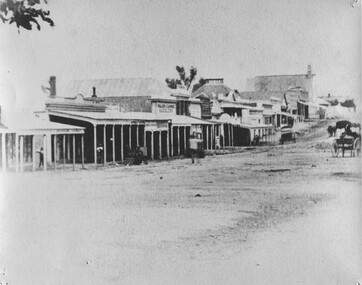
Photograph, 1859
Taken in Beechworth 1859, this photograph depicts the south side of Ford street looking towards the Methodist Church. The Methodist Church was built in 1857, and was the first permanent church building on the Ovens goldfields. It was one of the first permanent churches built on the Victorian goldfields, and the first on the Ovens goldfield. It demonstrates the rapid development which occurred in the goldfield towns following the discovery of gold in the early 1850s. It reflects the importance of Methodism in Victoria at this time, and the early activities of the Wesleyan Methodist Church in taking their religious message to the gold miners. [https://vhd.heritagecouncil.vic.gov.au/places/104] The buildings ceased being used as a church in 1966 when the Methodist and Congregational churches in Beechworth amalgamated.Black and white rectangular photograph. Image is printed on matte photographic paper. Obverse: NO INSCRIPTION Reverse: 7775 Ford St Looking Southwest 1859 Burke Museum Beechworth beechworth, ford street, methodist church, 1859 -
 The Beechworth Burke Museum
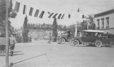
Photograph, 1928
Taken in Beechworth 1928, this photograph depicts Camp Street with an array of cars lined up and and people walking among them with a row of flags hung up across the street. The Back to Beechworth celebrations were held from Thursday 5th April 1928 until the following Wednesday. An estimate 750 people returned to Beechworth for the events that included church services, a ball, a picture show, cricket march, special dinner and a band recital. The event was planned to celebrate Beechworth winning the Sun News Pictorial Ideal Town Competition. Black and white rectangular photograph. Obverse: Back to Beechworth 1928 Reverse: BMM7782 56 burke museum, camp street, 1928, beechworth -
 The Beechworth Burke Museum
Photograph
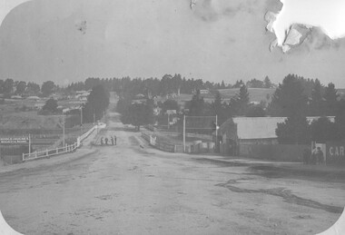
Taken in Beechworth, this photograph depicts Albert Road looking towards the Ovens and Murray Benevolent Asylum. In the center of the image are figures standing of a bridge. The Ovens Benevolent Asylum (or the Ovens and Murray Hospital for the Aged) was constructed in 1862 on an elevated site overlooking the township of Beechworth. This Asylum was built in response to boom in population due to the discovery of Gold in Beechworth in 1852. This period also saw the development of additional administration buildings such as; the Court house, the Town Hall, and offices. The original Benevolent Asylum building was designed in an unusual Flemish Gothic Revival style. The single storey building is of red brick on a dressed granite base, and the main facade is dominated by four curved, Flemish gable ends, those at the extremities being added to the original central section in 1867. This facade incorporates paired windows of pointed Gothic form and dark brick diaperwork patterning. The adjacent J. A. Wallace Wing of 1899 was designed by Donald Fiddes as a separate building. Also constructed of red brick, Fiddes adopted a conservative approach, designing a simple domestic scale building with central projecting gable porch and flanking bull nosed verandahs. The Benevolent Asylum was renamed the Ovens Benevolent Home in 1935 and The Ovens and Murray Home in 1954. Many buildings have been added to this site, particularly since the 1960s, including a poorly sited addition to the front of the original building. Extensive internal renovations have also been made to the original buildings. [https://vhd.heritagecouncil.vic.gov.au/places/118]Black and white rectangular photograph. The image is printed on matte photographic paper. Obverse: NO INSCRIPTION Reverse: BMM7590 1997.2848 AO2848 beechworth, albert road, benevolent, asylum, burke museum, photograph, black and white -
 The Beechworth Burke Museum
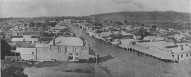
Photograph, 1876
Taken in Beechworth 1876, this panoramic photograph depicts Ford Street looking North. Black and white rectangular photograph printed on gloss photographic paper. Obverse: NO INSCRIPTION Reverse: 84-215-1 Panorama Streets Beechworth 1876 Town viewsbeechworth, ford street, town views, panorama -
 The Beechworth Burke Museum
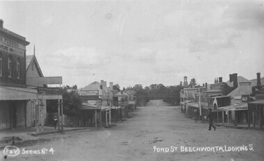
Photograph - Postcard
Taken in Beechworth, this photograph was taken from from close to Church Street intersection with Ford.Black and white rectangular post card.Obverse: F & V Series No 4 FORD ST BEECHWORTH, LOOKING.S Reverse: 1997.2753 AO2753 POST CARDbeechworth, ford street, town views -
 The Beechworth Burke Museum
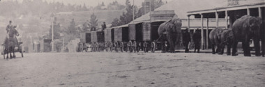
Photograph
The photograph is a reproduction of a lantern slide produced in 1880. The image depicts a circus arriving in town. The wagons are being pulled by an elephant.Black and white rectangular photograph printed on matte photographic paper.Reverse: 3291 / A03291 /entertainment album, circus, beechworth, 1800s, lantern slide, elephants, animals, performance, entertainment -
 The Beechworth Burke Museum
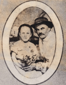
Photograph, Before 1918
Depicted is James Ashton (also known as Jim Ashton), a circus proprietor, crouched beside a seated small girl (or a lady with dwarfism). The two are dressed in formal attire, James is wearing a wide-brimmed hat, and together with the girl holding a small bouquet of flowers.James Ashton was the son of James Henry Ashton. James Henry Ashton founded Ashton Circus in the early 1800s, well before Federation. For over 160 years Ashton Circus has travelled to both regional towns and big cities, bringing joy to the people of Australia. Generations of the Ashtons crossed desserts and flooded rivers, drove over snow-covered mountains, fended off bushrangers, and even ventured where there were no roads to reach the communities that have loved and inspired our family of performers for over a century. People came from all around to enjoy Ashton Circus. In the 1800s, Ned Kelly watched our show on a number of occasions and even enjoyed tea with the performers after the show. The Ashton Family has grown and changed over eight generations since James Henry Ashton started his circus. Our family continues this great tradition, proud that we still bring affordable family entertainment to our fellow Australians. Today, the 4th, 5th, 6th, 7th and 8th generations of the Ashton family are still on tour, operating three individual circuses throughout Australia- each of having grown from the same roots.Black and white oval reproduced photograph printed on rectangular paper mounted on cardboardObverse: Jim Ashton was the first generation in Aus-/ tralia. His father came out in the 1840's and/ established a circus that toured the country. (printed)/ Reverse: 1997.2560 (in pencil)/ about 1860 (in blue pen)/ A02560 (in pencil)/entertainment album, burke museum, beechworth, circus, ashton circus, james ashton, jim ashton -
 The Beechworth Burke Museum
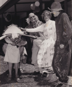
Photograph
Depicted are five unidentified performers. Two of them are guiding a prop. One of the male performers is wearing a mask. A sign in the background reads "Rayner Myrtleford", referring to Rayner St in Myrtleford; a town located approximately 28km south of Beechworth.The photograph provides insight into entertainment, performance and recreation in Beechworth during the 1950s. The item's interpretive capacity is enhanced by its strong relationship to other photographs in the catalogue. Collectively, these records enrich the community's understanding of how the arts have developed in Beechworth since the mid-twentieth century.Black and white rectangular photograph printed on matte photographic paper.Reverse: 5667 /entertainment, entertainment album, performance, arts, theatre, play, theatrical group, myrtleford, beechworth, rayner st -
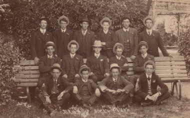 The Beechworth Burke Museum
Postcard
Taken in c. 1912-13, depicted are fifteen young men dressed in suits and hats. They are posing around a park bench located in the Town Hall Gardens, Beechworth.Sepia rectangular photograph printed on card.Reverse: Beechworth boys / 97.2333 / POST CARD / KODAK CORRESPONDENCE / ADDRESS ONLY / AUSTRAL / AUSTRAL / BR / - / - / - / 4 George Alexander / KODAK / 1912 - 13? /entertainment album, entertainment, beechworth, town hall gardens, postcard, 1910s -
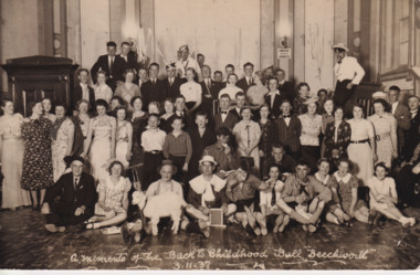 The Beechworth Burke Museum
Postcard
The postcard depicts a large group of young men and women posing inside the Beechworth Town Hall. They are attending the Back to Childhood Ball in Beechworth on 3 November 1937. Joining them is a small goat in the front row.The postcard provides insight into entertainment, leisure and recreation in Beechworth during the 1930s. It enriches the community's understanding of how entertainment has developed in Beechworth since the early twentieth century.Black and white rectangular postcard printed on card.Obverse: a memento of the Back To Childhood Ball "Beechworth" / 3.11.37 / Reverse: 3708 / POST CARD / KODAK / CORRESPONDENCE / ADDRESS ONLY / AUSTRAL / A / AUSTRAL / KODAK / N. R. McGEEHAN, (Flashlight Specialist.) / 154 HOTHAM ST., ST. KILDA. S. 2. /entertainment, entertainment album, beechworth, 1930s, goat, recreation, performance, leisure, back to childhood ball, social -
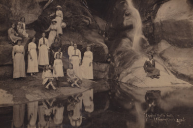 The Beechworth Burke Museum
Photograph, 1910
Taken in 1910, the photograph depicts a group of young, unidentified women attending a picnic in Bright; a town located in Victoria's high country.The photograph provides insight into the types of leisure activities enjoyed by residents living in Beechworth and surrounding towns. Its historical significance is strengthened by its production in 1910. Consequently, the record can be used as a resource to study the state of the natural environment in Bright at this time.Black and white rectangular photograph printed on matte photographic paper mounted on board.Obverse: "Ladies Bath" Falls / F. Foxcroft photo / Bright. / Reverse: 1997.2636 / Vera + Dorrie / Picnic at Bright area / 1910 / x / x /entertainment album, picnic, beechworth, bright, victoria, high country, 1900s, leisure -
 The Beechworth Burke Museum
Photograph, 1910
Lord Kitchener visited Seymour as part of his review of Australia's military capabilities. Lord Kitchener was Commander-in-Chief of the British Army at the time of his visit. At the invitation of Prime Minister Alfred Deakin, Kitchener visited Australia in 1909 to inspect the existing state of defence preparedness of the Commonwealth, and advise on the best means of providing Australia with a land defence. Kitchener’s report, submitted in February 1910, recommended the introduction of compulsory military training which was immediately adopted, as was the establishment of the Military College, Duntroon: It has been definitely decided that Seymour will be the site of the Kitchener camp. The troops which will make the strongest muster at the camp will be the Light Horse. This being so, the suitability of the chosen area for cavalry operations has necessarily had to be considered in selecting the site, and an additional factor is that Seymour is practically in the centre of the Light Horse districts. The country round Seymour is also suitable for artillery manoeurves, and there is no available area in the vicinity of Melbourne where these could be so well carried out. As it is considered that Field-Marshal Lord Kitchener will desire to see the troops on the move, the reason for choosing such a district as Seymour is apparent. The eight days to be devoted to the camp will be mainly occupied in moving the troops over a considerable area, and in carrying out certain tactical operations. Many of the sites recommended have been inspected by officers of the head quarter staff, and all that now remains is that the exact situation for the main camp should be selected, Major Luscombe will visit Seymour on Saturday to inspect the surround country, and select the most suitable places. The intention will be directed to sites closer to the town. Yea Chronicle (Yea, Vic), 9 December 1909. Black and white rectangular photograph printed on matte photographic paper and mounted on board.Obverse: Beechworth Light Horse (pen) / Kitchener Camp / Seymour / 1910 / Reverse: 8743 / Mrs R Scott / military album, burke museum, burke, beechworth, beechworth light horse, light horse, world war one, wwi, 1910 -
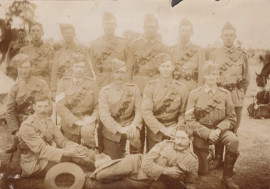
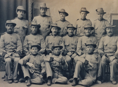 The Beechworth Burke Museum
Photograph
It is believed that the photograph was taken between 1899 - 1903. Depicted is a group of fourteen unidentified young men dressed in Australian military uniforms. A few of them are holding swords. This group were part of the Beechworth Mounted Rifles; a voluntary detachment of the Australian Light Horse Militia. This unit consisted of soldiers from the Euroa, Longwood, Violet Town, Benalla, Thoona, Wangaratta, Rutherglen, and Beechworth Detachments of Victorian Rifles, and subsequently formed into the 8th Australian Light Horse Regiment (Victorian Mounted Rifles). The Victorian Mounted Rifles was gazetted as a volunteer formation on 2 December 1885 with the aim of consolidating all the disparate calvary units dispersed across Victoria into a coordinated and single administrative and military unit. Two contingents of the Victorian Mounted Rifles fought during the Second Boer War (11 October 1889 - 31 May 1902). This conflict was fought between the British Empire and two independent Boer states; the South African Republic and the Orange Free State, over the Empire's influence in South Africa.The photograph is historically significant due to its connection to the Second Boer War and Australian Light Horse Regiment. This significance is enhanced by Australia's involvement in this war, specifically of the Victorian Mounted Rifles. This unit retains a special significance within Victorian culture, as there is a memorial and monument - erected in 1903 - honouring their service on St. Kilda Road in Melbourne. The record has strong research potential. This is due to the ongoing scholarly and public interest in war, military history, and the ANZAC legend. The historic context of this record can provide insight into Australia's history, military and defence policies. Lastly, as the Victorian Mounted Rifles remain a largely unexplored topic in comparison to other military units and divisions, the record presents a unique opportunity for further and important study and research.Sepia rectangular photograph printed on matte photographic paper.Reverse: BMM2638 / 071 1NA211 22JAN98 FOTOSUPPLIES........ ........................................ /military album, beechworth mounted rifles, australian light horse militia, second boer war, victorian mounted rifles, australian light horse regiment, military, war, british empire, south africa, 1800s, 1900s, australian army -
 The Beechworth Burke Museum
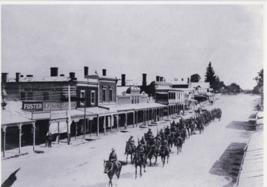
Photograph, 1908
Taken in 1908, the photograph depicts a long line of Australian soldiers riding atop horses. They marching down Ford St, Beechworth. This group were part of the Beechworth Mounted Rifles; a voluntary detachment of the Australian Light Horse Militia. This unit consisted of soldiers from the Euroa, Longwood, Violet Town, Benalla, Thoona, Wangaratta, Rutherglen, and Beechworth Detachments of Victorian Rifles, and subsequently formed into the 8th Australian Light Horse Regiment (Victorian Mounted Rifles). The Victorian Mounted Rifles was gazetted as a volunteer formation on 2 December 1885 with the aim of consolidating all the disparate calvary units dispersed across Victoria into a coordinated and single administrative and military unit. The Victorian Mounted Rifles fought in the Second Boer War (1889 - 1902), although it is unknown if the group depicted in this image were involved in the conflict.The photograph is historically significant due to its connection to the Australian Light Horse Regiment, specifically of the Victorian Mounted Rifles. This unit retains a special significance within Victorian culture, as there is a memorial and monument - erected in 1903 - honouring their service on St. Kilda Road in Melbourne. The record has strong research potential. This is due to the ongoing scholarly and public interest in war, military history, and the ANZAC legend. The historic context of this record can provide insight into Australia's history, military and defence policies. Lastly, as the Victorian Mounted Rifles remain a largely unexplored topic in comparison to other military units and divisions, the record presents a unique opportunity for further and important study and research.Black and white rectangular photograph printed on matte photographic paper.military album, military, war, wwi, world war i, beechworth, ford st, parade, horses, mounted rifles, soldiers, victorian mounted rifles, australian light horse militia -
 Ballarat Fire Brigade
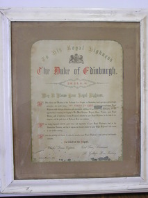
Certificate, just prior to December 10th, 1867
Certificate is of the pledge that the brigade made to His Royal Highness the Duke of Edinburugh at a dinner that the Duke attended at the Ballarat Fire Station on 10th December 1867 during a royal visit to the district. White timber framed pledge from the Ballarat Fire Brigade to His Royal Highness the Duke of Edinburugh during his royal visit in December 1867. Pledge is on white paper with a coat of arms near the centre at the top of the page. Lettering is mainly in black ink with some red coloured letters being used. Certificate has a light brown coloured border around it with a hand drawn scrolled decorative edge made in gold colour. To His Royal Higness / The Duke of Edinburugh / May It Please Your Royal Highness / We Othe fficers and Members of the Ballaarat Fire Brigade, an institution based upon pure philanthropic / principles, our motto being "We Strive to Save" bear to approach your Royal / Highness with feelings of devotion and attachment, and deep felt gratitude to the Almighty, for this / opportunity of envicingour loyalty to Her Most Gracious Majesty Queen Victoria, your Royal / Mother: and, of tendering a hearty Firemans welcome to Your Royal Highness, in the land of our / adoption, and the good town of Ballaarat East, our residence. / We are deeply impressed with the great honor and importance of your Royal Higness's visit to the / Australian Colonies, and beg to express our fervent wishes for your Royal Highness's safe return / to our mother country. / We have the privilege and honor, to subscribe ourselves your Royal Higness's most obedient and humble / servants. / On behalf of the Brigade / Charles Dunn, Captain Carl Franz, Lieutenant / R. Geilhofer, Hon. Secretary / Ballaarat, December, 1867ballarat fire brigade, queen victoria, his royal higness, the duke of edinburugh, december 1867, 1867, captain charles dunn, captain dunn, lieutenant carl franz, lieutenant franz, honourary secretary r geilhofer, his royal highness the duke of edinburugh -
 Ringwood and District Historical Society
Map - Public Land Sale by Thomas Ham, 2000 Acres for Sale - Crown Sections 20, 23, 24 - Ringwood, Victoria - 1855
Two 1850s surveyor's maps on cardboard backing showing area from Melbourne extending East beyond Bulleen and Nunawading. Detailed description of lots for sale and navigational directions to the property from Richmond by Thomas Ham, Victorian public servant, map maker, publisher, lithographer and original Ringwood land owner. Inset map enlarging area between Yarra River and Dandenong Creek, with southern boundary of allotments later forming part of Oban Road, North Ringwood.TRANSCRIPT: "This really valuable Property is now offered to the public for sale, in lots to suit purchasers at the Iow rate of £1 per Acre for 80 acres and upwards, and £1.10s per Acre for any smaller portion. Terms of payment Half Cash, Balance in 6 and 12 months, bearing 8 per cent interest. The Estate is well wooded with Gum, Cherry Tree and Stringy Bark, with Wattle in the valleys of the several creeks. Every lot is Staked and Trenched at the corners marked on the Plan thus - The Surveyor has carefully sub-divided the Property, in order to give every Farm a Creek for Water, Valley for Cultivation, and Hills for House and Grass Paddock. The ROADS have been very carefully laid out so as to give a firm, well drained, and nearly level road to each Homestead. Intending purchasers can readily find the property by the following directions, viz: Start from Richmond Bridge, at Hawthorne, then take the left-hand road to KEW. When at the "Woodman Inn", take the Cotham Road to the right, bearing due east, keep this Road, passing Trainor's "White Horse" Inn, and before you leave the fences, you will see calico bills (see margin) nailed to the Trees on the bush track leading to the Upper Yarra country, follow the Bills till you come to the SOUTH boundary line of the Property, which bears East and West (see Plan) where you will see Bills nailed up "THIS PROPERTY FOR SALE, etc." The Bills from Town lead direct to where Mr. Jull is erecting his Store, and arrangements have been made with him to show the lots to intending purchasers free of charge. At the respective corners of the lots the Bills are nailed up double, with numbers to denote the lot, and that the corner stake is adjacent. Any parties wishing to proceed to the property by way of BULLEEN will find Bills nailed on the Trees, commencing at the NEW INN, at "Wilson's Slip Rail." Keep this Track till you come to the Log Bridge, over the Deep Creek at Bloxhome's Paddock; go through the land now being cleared; keep the track over the hill till you come to an Iron House, you will then be on the property, which Iies to the North and East as per Plan. Follow the Bills till you come to Mr. Jull's Store, etc. etc. Further particulars can be had from the Agent for the Property. THOMAS HAM. " -
 Mission to Seafarers Victoria
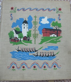
Album - Photographic album, Ports of call with the M/S Mongabarra from December 1st 1949 to July 23rd 1950, 1949
The album tells the story of ports visited by Allan Charles Quinn during his service on board the M/S "Mongabarra". He signed on in San Francisco on December 1, 1949. Note this trip overlapped with the Album (00278) which documents the next trip Quinn made to Africa out of Gothenburg. The album preserves a 1950s perspective of a Merchant Seaman and his experience of the respective Ports at that time. The Collection is especially useful when viewed along with contemporary Quinn family correspondence.Album with metal Metal binder rings at spine and beige fabric cover with gouache printed colour design featuring scandinavian buildings. The album contains 25 pages of b/w mounted photographs. Some are missing. The cover is illustrated with colour screenprinted pictures of a white tower on the left and a brown Barn-like building on the right. There are stylised canoe boats containing rowers in the foreground.. On the inside front cover is a handwritten itinerary of the places visited.On front cover possible designer printed signature in black: "Grane"; On inside front cover on adhered sheet of paper in aqua ink lists intinerary/ index of 20 Ports visited: Title (see above) / "Signed on in San Francisco December 1st 1949 / " then a header line for 4 columns: " PORT COUNTRY ARRIVED DEPARTED / 1. San Francisco U.S.A 10-10-49 4-12-49 / ... / 10. ADELAIDE ... 11-4-50 19-4-50 / .../ 20. HALDEN NORWAY 23-7 - 50 25-7-50" ; Most of the photographs in the Album also annotated and dated ; inside back cover has an embossed letter R.album, photograph, ms mongbarra, san francisco, dunkirk, voyages, allan quinn, barbara quinn, seafaring life, ww2, seafarer, melbourne, sydney, brisbane, san pedro, newcastle, adelaide, port pirie, port lincoln, cape town, las palmas, australia, south africa, canary islands, usa, united states, france, antwerp, belgium, hull, england, hamburg, germany, copenhagen, denmark, gothenburg, norway, sweden, halden, malmö -
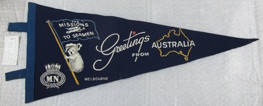 Mission to Seafarers Victoria
Flag - Pennant, The Missions to Seamen - Greetings From Australia, 1940-1949
This pennant was donated to the Mission by June Muirhead (nee Richardson) who visited the Mission on two occasions: on the 13 November 2014 and then in 2016. She lived from age 3 to 8, with her parents, Cuthbert (Bert) Richardson and Jane (Jenny) Richardson, and her sister, Edna, in the Cottage at 717 Flinders Street. Her father, was the caretaker of the Flinders Street building between 1943-1949. . In 1943 her father was hired to work at the Mission as a caretaker. The family moved from Wonthaggi. When she lived in the Mission, she would sometimes sneak into the club to look at books and pictures. Some seafarers would give her badges, tokens. One of them gave her this felt pennant. In 1949, the family moved back to Wonthaggi and June started year 5 over there.A number of souvenir gifts and small boxes were apparently available through the Mission To Seamen in the 1940s. This acquisition adds to the small collection of items from the period which could be used to form the core of an informative exhibition. Similar flags were made in other countries depicting an animal (kiwi bird in New Zealand, springbox in South Africa) and other Australian towns.A triangular felted, dark blue pennant with printed cursive inscription and motifs including: the Mission to Seamen Flying Angel flag, an outline of Australia; a Koala wearing a captain's hat; an insignia emblem for the Merchant Navy. A looped cotton binding along left edge of the triangle to thread the flag on a stick or cord support. The printed inscription reads: Greetings from Australia.pennant, flags, koala, flying angel club, merchant navy, d. june muirhead, marketing, caretaker, cottage, bert richardson, june muirhead nee richardson, edna richardson, ww2 -
 Orbost & District Historical Society
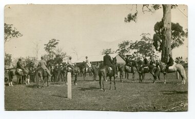
black and white photograph, 1907
... are an important part of cultural life in small country towns ...This photograph shows the show ring at the Orbost Annual Agricultural Show in 1907. The first meeting to form an Agricultural society in Orbost was convened by the then Orbost Progress Association and held in the Mechanics Hall on Saturday, 10th October 1891. Its first show was held on 3rd March 1904...on a site alongside the Bonang Road where the present Golf Club stands. It is currently held at the Recreation Reserve at Newmerella. (Ref: In Times Gone By-Deborah Hall) This item is associated with the Orbost Agricultural Society 's Annual Show which has been a major event in Orbost for over a century. Agricultural shows are an important part of cultural life in small country towns and the Orbost Show is an integral part of Orbost 's agricultural history. A black / white photograph of a large group of riders on horseback. They are in a paddock. In the background is a wooden building.on back - "Orbost Agric. Show Ring, 1907, Mrs A M Marshal East Bairnsdale"orbost-agricultural-show-event -
 Orbost & District Historical Society
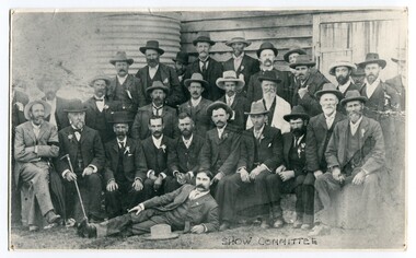
black / white photograph, early 20th century
... in small country towns and the Orbost Show is an integral part ...This photograph shows an early Orbost Agricultural Show committee. Included in the photograph are: Phil Nixon; John Johnston; Percy Morris; Harry Richardson; Arthur Saunders; Archie Rodwell; Geo. Nixon; J. Warren; John Draffin; W. Fisher; D.R. Norris; Paul Hocking; Waller; JasHossack; Jim Cameron; John Cameron. The first meeting to form an Agricultural society in Orbost was convened by the then Orbost Progress Association and held in the Mechanics Hall on Saturday, 10th October 1891. Its first show was held on 3rd March 1904...on a site alongside the Bonang Road where the present Golf Club stands. It is currently held at the Recreation Reserve at Newmerella. (Ref: In Times Gone By-Deborah Hall) This item is associated with the Orbost Agricultural Society 's Annual Show which has been a major event in Orbost for over a century. Agricultural shows are an important part of cultural life in small country towns and the Orbost Show is an integral part of Orbost 's agricultural history. A large black / white photograph of a large group of men outside a wooden building. There is a tank on the left side. Some men are standing, some sitting and the man if front is lying , leaning on his elbow. There is a smaller copy of same photograph.on front - "show committee"orbost-agricultural-show-committee -
 Orbost & District Historical Society
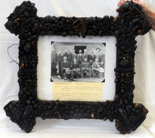
framed photograph, C 1904
... of cultural life in small country towns and the Orbost Show ...The first meeting to form an Agricultural society in Orbost was convened by the then Orbost Progress Association and held in the Mechanics Hall on Saturday, 10th October 1891. Its first show was held on 3rd March 1904...on a site alongside the Bonang Road where the present Golf Club stands. It is currently held at the Recreation Reserve at Newmerella. (Ref: In Times Gone By-Deborah Hall) This frame was made by Mary Lynch, wife of Matt Lynch. Pictured in the photograph are: Back: W. Fisher, Archie Rodwell, Mat Lynch, Rupert Mosley, George Granter, Arthur Saunders, Arther Pardew, John Bird, John Gilbert. Front: Bill Ginning, George Perry (secretary) John Johnston (president), Carl Dreverman.This item is associated with the Orbost Agricultural Society 's Annual Show which has been a major event in Orbost for over a century. Agricultural shows are an important part of cultural life in small country towns and the Orbost Show is an integral part of Orbost 's agricultural history. It is also an example of the craft skills of women in the early 20th century.A black / white photograph of a group of thirteen men, some standing, some sitting in front of a wooden shed. The photograph is in an ornate frame made of dried seeds.on front - "Orbost Agricultural Show Committee probably 1904"orbost-agricultural-society lynch-mary orbost-show -
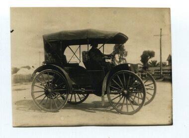 Orbost & District Historical Society
black and white photograph, 1910
... , farmers, doctors, and town and country salesmen. It was said ...Alan Richardson was born in 1853 and died in 1936. He was a sawmiller at Tabbara who built and held the ticket for the Paddle Steamer Curlip. PS Curlip was registered in 1893 and the Passenger Certificate issued on 30th January 1903 to Captain Alan Richardson by the Marine Board of Victoria entitled her to carry 25 passengers and only 10 passengers when engaged in towage service. Two children under 12 years of age to be reckoned as one passenger. He had the first horseless motor buggy in Orbost. Alan Richardson was married to Emily Dawson and had two children - Alan Jnr and Ruth.Before the First World War, few people in Australia owned or knew how to drive cars before they bought them. This International auto buggy was promoted as a useful vehicle for station owners, farmers, doctors, and town and country salesmen. It was said to be the cheapest automobile in Australia (at one third the cost of a conventional car), required much less maintenance, had durable solid rubber tyres rather than troublesome pneumatic ones, and didn’t need a chauffeur. This is a pictorial record of a "horseless buggy" which would have been a novelty in the early 20th century in Orbost. The item is associated with the Richardson family, early Orbost settlers.A small black / white photograph of a motor vehicle with a man seated at the steering wheel. The vehicle has large buggy wheels with mud guards. It is open with no windows.transport motor-vehicle horseless-buggy richardson-alan -
 Orbost & District Historical Society
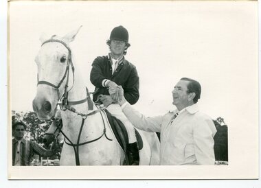
black and white photographs, Snowy River Mail, March 12 1980
... country towns and the Orbost Show is an integral part of Orbost 's ...These photographs were taken at the 1980 annual Orbost Show. The first photograph is of Mr Frank Rourke congratulating Combienbar rider, Gavin Chester, East Gippsland Olympian ( a member of the 1980 Australian team which did not compete in Moscow). He won the title of Champion Show Jumper riding his mount "Blue Trick" on Monday March 10 1980. The second photograph shows Mr Frank Rourke placing the winning ribbon around the neck of Gavin Chester's winning mount, "Blue Trick" The third photograph is the winner of the coveted R.L.Fisher Memorial Plate won by Eric Musgrave being congratulated by Mr Frank Rourke. Frank Rourke was the Gippsland and Northern manager. G. & N. sponsored the event which carried a prize of $500. On the left in this photograph is Mr J. Horstman, ring four judge.This is a pictorial record of a significant event in Orbost. This item is also associated with the Orbost Agricultural Society 's Annual Show which has been a major event in Orbost for over a century. Agricultural shows are an important part of cultural life in small country towns and the Orbost Show is an integral part of Orbost 's agricultural history.Three black / white photographs of a rider on horseback receiving congratulations. There are details on labels on the back of each photograph.orbost-show equestrian chester-gavin musgrave-eric show-jumping -
 Orbost & District Historical Society
black and white photographs, March 13 1978
... shows are an important part of cultural life in small country ...3084.1 is titled "Ready For Launching" and is of Mr Lachlan Macalaster on the left and Mr Jim Holden preparing to release two roosters for a competition - The Rooster Chase,. 3084.2 was taken at the 1978 annual Orbost Show in a new division for goats. the photograph was taken during the judging. Linda and Val Donald are in the photograph' 3084.3 and 3084.4 are of the new pavillion at Newmerella Recreation Ground,This is a pictorial record associated with the annual Orbost Show which has been a major event in Orbost for over a century. Agricultural shows are an important part of cultural life in small country towns and the Orbost Show is an integral part of Orbost 's agricultural history.Four black / white photographs. 3084.1 shows two men each holding a rooster. 3084.2 shows a group of five people standing near some goats. 3084.3 and 3084.4 are of the construction of a large metal shed.Each photograph has a label on the back with detailed information.orbost-show macalaster-lachlan holden-jim donald-val agriculture -
 Orbost & District Historical Society
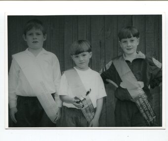
black and white photographs, second half 20th century - 1980's?
... country towns and the Orbost Show is an integral part of Orbost 's ...These photographs are of winners in the Orbost Agricultural Show's Show Boy and Show Girl competitions. The first photograph is of Peter? Joiner and Jarod Forrester in the Master Show Bow Competition. The second is of Pauline Bommer (Weston) and her daughter at the Nowa Nowa Gymkhana. The third has Chloe Kenny on the left. in the fourth photograph are Dianna Munn with Laura; Sharon Chambers with Jessica and Sharon Cook with Tayla. These photographs are pictorial records of a social event in Orbost. They are associated with the Orbost Agricultural Society 's Annual Show which has been a major event in Orbost for over a century. Agricultural shows are an important part of cultural life in small country towns and the Orbost Show is an integral part of Orbost 's agricultural history. Four black / white photographs related to the Orbost Show. 3086.1 is of three young boys wearing sashes. The middle boy is holding a trophy. 3086.2 shows a woman bending over a young girl wearing a sash. 3086.3 has three girls, one one right wearing a hat, one on left has a sash. 3086.4 is of three women holding babies. All babies have sashes and the one in the middle has a trophyOn the back of each photo are the details and names. -
 Orbost & District Historical Society
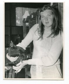
photographs, Snowy River Mail, C1968
... are an important part of cultural life in small country towns ...These photographs were probably published in the Snowy River Mail. Some of the Orbost identities in the photographs are: Jim Holden; Brian Morgan; Clarrie Ingram; Jeffrey Fecondo; David Holden; Brian Holden; Richard Morgan; Sue Joiner and Charlie Owen. They were taken in the Poultry Shed at the Orbost Show at the Newmerella Showground. The first meeting to form an Agricultural society in Orbost was convened by the then Orbost Progress Association and held in the Mechanics Hall on Saturday, 10th October 1891. Its first show was held on 3rd March 1904...on a site alongside the Bonang Road where the present Golf Club stands. It is currently held at the Recreation Reserve at Newmerella. (Ref: In Times Gone By-Deborah Hall)These photographs are associated with the Orbost Agricultural Society 's Annual Show which has been a major event in Orbost for over a century. Agricultural shows are an important part of cultural life in small country towns and the Orbost Show is an integral part of Orbost 's agricultural history.Twenty-two black / white photographs and four coloured photographs. all are related to the Orbost Agricultural Show.poultry agriculture-show-orbost -
 Orbost & District Historical Society
black and white photographs, Snowy River Mail, 1960s
... in small country towns and the Orbost Show is an integral part ...These photographs were taken at the annual Orbost Agricultural Show at the Newmerella Showground. They were probably published in the Snowy River Mail newspaper. Some of the Orbost identities pictured include : Russell Crofts, Kevin McDonald, Brian McDonald, Gail & Lee Winchester, Julie & Lisa Drummond, Marion Russell, Sylvia MurrayRod Kleinitz, Rober Morgan, Trevor Perry, Brian Woodlands, anna light, Louella Brunt, Colin Weir, Wendy Pinnock, Raeleen Reed, Margaret Joiner and Jo-anne Mundy. The first meeting to form an Agricultural society in Orbost was convened by the then Orbost Progress Association and held in the Mechanics Hall on Saturday, 10th October 1891. Its first show was held on 3rd March 1904...on a site alongside the Bonang Road where the present Golf Club stands. It is currently held at the Recreation Reserve at Newmerella. (Ref: In Times Gone By-Deborah Hall)These photographs are associated with the Orbost Agricultural Society 's Annual Show which has been a major event in Orbost for over a century. Agricultural shows are an important part of cultural life in small country towns and the Orbost Show is an integral part of Orbost 's agricultural history. Seventeen black / white phootgraphs which were taken at the Orbost Agricultural Show.orbost-agricultural-show -
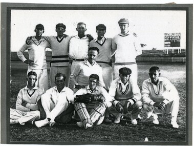 Orbost & District Historical Society
black and white photograph, 1931 - 1932
This photograph was taken during the Country Week Cricket Team 1932-33 championships. This carnival was established in 1922. Back: L-R: Jack Ralston, Royce Andrews, Harry Perry, ? ? Middle:? Front: ? ? , Frank Meehan, Dr. Nettleton. Cricket has been played in Australia for over 210 years and is one of the most popular sports in Australia at international, domestic and local levels. Sport in small towns is an integral part of community life contributing to community identity, sense of place, social interaction and good health. This item is a pictorial record of cricketing in Orbost.A laminated black / white photograph of a cricket team. Five men are standing in the back row, one kneeling in the middle row and five seated on the grass at the front. All are dressed in cricket whites. The man in the middle front is wearing leg guards. In the background on the right is a score board.on back on a label - "Doc Nettleton"cricket-orbost sport-cricket country-week-cricket-team-1932-1933 ralston-jack andrews-royce perry-harry meehan-frank nettleton-dr -
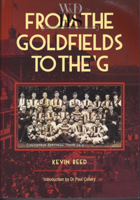 Warrnambool and District Historical Society Inc.
Book, Kevin Reed, From the Goldfields to the G, 2014
... of Australian football in country towns and cities warrnambool kevin ...An account of the development of Australian Rules football in both rural and suburban Victoria.This is a paper back book with a red and gold cover with a photograph of Costerfield Football Team, 1919 on the cover (335 pages) The book is signed inside by Kevin Reed non-fictionAn account of the development of Australian Rules football in both rural and suburban Victoria.warrnambool, kevin reed, dr john douglas, warrnambool cricket 1980's, warrnambool football 1970's 1980's -
 Warrnambool and District Historical Society Inc.
Financial record - Journal Town of Warrnambool 1906-1914, Circa 1906
This journal contains entries which relate to the expenses of the administration of the town in the early 20th Century. It contains entries which relate to items such as public works, kerbing and channelling, library and museum, abattoir fees, pure food act, limestone and bluestone road metal and salaries.The entries in this journal provide an overview of expenses and administration costs in early 20th century. There is much information contained in the costs which states when works were completed.Green cloth covered card journal with light brown leather spine and corners. Scrolled brown pattern down edges of spine cover. Edges of pages coloured in green, pink and yellow. Inside front and back covers is coloured light and dark blue. 103 pages. Maroon label on front cover with gold lettering and border. It contains three loose sheets of paper. One dated November 1912 written by H E Lawson calling on subscriptions to support a group to lobby for country interests. A second sheet refers to a poll for a new High School for Warrnambool. The other two sheets refer to voting rights. Journal Town of Warrnambool on front cover. Arnall and Jackson engravers and lithographers, Printers and manufacturing stationers 478 Collins St Melbourne No 96927 9/6/06.town of warrnambool1906-1914, warrnambool history, warrnambool town expenses 1910