Showing 4978 items matching " dandenong road"
-
 Ringwood and District Historical Society
Document - Folder, Land Sale, Parkhaven Estate, Heathmont, Victoria - 1968
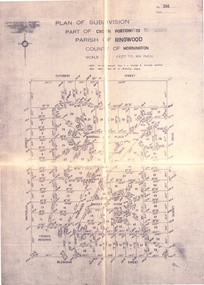
... Home Industries Limited, Lower Dandenong Road, Braeside, Vic... - Consolidated Home Industries Limited, Lower Dandenong Road, Braeside ...Manilla folder containing 2-page foolscap size typewritten summary of Parkhaven Estate Heathmont multiple release allotment prices and two maps headed Plan of Subdivision - Part of Crown Portion 13, Parish of Ringwood. Subdivision includes Cuthbert Street, Waterloo Street, Sunset Drive, Markhill Place, Parkhaven Drive, Bayley Close and Blenheim Street. Agents - Consolidated Home Industries Limited, Lower Dandenong Road, Braeside, Vic., Phone 91-9791. Rep - Bruce Grant.Accompanying handwritten sales note researched in 2024 by Richard Carter - Carter Real Estate - "Generally $2500 to $4000 per lot". -
 Melbourne Tram Museum
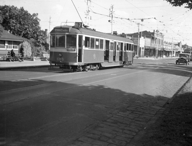
Administrative record - Depot Table Sheet or Block, Melbourne & Metropolitan Tramways Board (MMTB), "Sunday 14-1-1968 - Glenhuntly - North Fitzroy - Kew - Malvern - Doncaster", Jan. 1968
... . The block was prepared for the track work to realign Dandenong Road.... The block was prepared for the track work to realign Dandenong Road ...Depot table sheet or block - roneo or spirit duplicated, printed on light card - for - "Sunday 14-1-1968 - Glenhuntly - North Fitzroy - Kew - Malvern - Doncaster" shows the various runs and crew tables for the day, has an index and notes. The block was prepared for the track work to realign Dandenong Road and the Chapel St intersection as part of the St Kilda Junction project. See page 96 of Timeline History of Melbourne's Government Cable and Electric Trams - Barry George et al.trams, tramways, table cards, glenhuntly tram depot, kew depot, north fitzroy depot, doncaster depot, malvern depot, drivers, conductors, st kilda junction -
 Melbourne Tram Museum
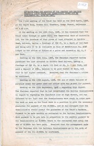
Document - Notice, Melbourne & Metropolitan Tramways Board (MMTB), Tramway Board (MMTB), Fares Caufield Racecourse, Sept. 1948
... Racecourse, via Dandenong Road on Showday 30-9-1948. Gives the fares... Racecourse, via Dandenong Road on Showday 30-9-1948. Gives the fares ...Notice No. D6406 and D6407, issued to advise Drivers and Conductors of the through trams from St Kilda Beach to Caulfield Racecourse, via Dandenong Road on Showday 30-9-1948. Gives the fares to be charged for each section for both the forward and return journeys. Second page gives the fares for special trams from the Racecourse to Cotham Road Kew - minimum fare for 4d. Issued to crews at Malvern and Kew Depots.Yields information the tram fare arrangements for the Caulfield Races Show Day in 1948.Document two foolscap duplicated sheets, pinned in top left hand corner.tramways, caulfield races, special trams, fares, tickets, notices to staff -
 Ringwood and District Historical Society
Flyer, Land Sale Advertisement - East Ringwood Township Estates, East Ringwood, Victoria - circa 1920
... Subdivision plans include Mount Dandenong Road, Grey Street... Dandenong Road, Grey Street, Eastfield Road, King Street, Everard ...The date of the flyer as circa 1920 can be estimated from the references to the (decision on) "electrification of the Croydon Railway Line" which eventually occurred in 1923, letting of tenders for the state school building which opened in 1924, and the "proposed new railway station" (East Ringwood) which opened in 1925, Advertisement for three retail and residential allotment land sales in East Ringwood Township including maps showing layout of subdivisions. Township Estate, State School Estate, and East Ringwood Station Estate.Subdivision plans include Mount Dandenong Road, Grey Street, Eastfield Road, King Street, Everard Road, Holland Road, Purser Avenue, and Charles Street. (Agents) Spencer Jackson, Subdivider & Homebuilder, 341 Collins Street, Melbourne, Phones: M2327 (3 lines), also at Dromana, Phone 65. -
 Whitehorse Historical Society Inc.
Photograph - B/W Photograph, East Burwood Public Hall East Burwood, 1971
... Black and White Photo of Area North of Burwood Road near... of Area North of Burwood Road near Dandenong Creek East Burwood ...Black and White Photo of Area North of Burwood Road near Dandenong Creekeast burwood public hall, halls -
 Ringwood and District Historical Society
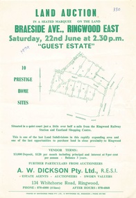
Flyer - Land Auction, Guest Estate, Ringwood East - 1974
... Subdivision layout includes Mount Dandenong Road, Braeside...Subdivision layout includes Mount Dandenong Road, Braeside ...Two copies of single page with green print advertising auction of ten home sites on Saturday 22nd June (1974). Details include subdivision map and vendor terms. Second copy of flyer includes handwritten notation of allotment sale prices.Subdivision layout includes Mount Dandenong Road, Braeside Avenue and Guest Close, Ringwood East. Agent: A.W. Dickson, 136 Whitehorse Road, Ringwood, Phone 870-6000, after hours 870-6868. Printed by Whitehorse Press Pty. Ltd., 14 Whitehorse Road, Ringwood, Phone 870-7855. -
 City of Kingston
Photograph - Black and white, 17 January 1951
... Road, Moorabbin (bottom left), Centre Dandenong Road Cheltenham... Dandenong Road Cheltenham (top left), Park Road, Cheltenham (top ...Moorabbin, Cheltenham and Highett are suburbs in the City of Kingston with a diverse mix of development and zoning. This 1954 image shows the market gardens, farms and paddocks of the Moorabbin and Cheltenham area. which have gradually been sub-divided into The Highett Gas Works is visible and Cheltenham Park and Victoria Golf Club.The suburbs of Cheltenham and Moorabbin were originally developed with extensive market gardens. Over time the district has been transformed with the farms and paddocks replaced by housing, factories and shopping centres. The Highett Gas Works on the Nepean Highway was a significant feature of the landscape and has now been demolished. and the site has undergone remediation.Aerial photograph of Cheltenham, Moorabbin and Highett within the City of Kingston. The area depicted in this 1951 aerial view includes Wickham Road, Highett (bottom right), Keys Road, Moorabbin (bottom left), Centre Dandenong Road Cheltenham (top left), Park Road, Cheltenham (top right), Nepean Highway (left section), Graham Road and Middleton Street, Highett (bottom right). Cheltenham Park and Victoria Golf Club are visible. Nepean Highway and the Frankston railway line run centrally through the image.White type: 1416-37 538 RUN239 LENS 5312" MELBOURNE METROPOLITAN 12150 17-1-51 ↆ M539 Black pencil: N [arrow]cheltenham, highett, highett gas works, market gardens -
 Ringwood and District Historical Society
Flyer, Land Sale Advertisement - Sunbeam Estate, East Ringwood, Victoria - circa 1930
... Avenue, Mount Dandenong Road, and Lilydale Road (later Old... Road, Everard Road, Sunbeam Avenue, Mount Dandenong Road ...Folded double-sided page advertising private sale of 48 residential allotments, with location map, terms of sale, and details of local features and services. Locality plan includes Holland Road, Everard Road, Sunbeam Avenue, Mount Dandenong Road, and Lilydale Road (later Old Lilydale Road). (Agents) Phillips & Nicholson, 59 Swanston Street, Melbourne, (Phone) Central 10907, in conjunction with C.E. Carter, Bank Chambers, Main Street, Ringwood, Telephone Ringwood 24. -
 Ringwood and District Historical Society
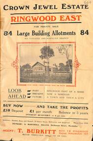
Flyer, Subdivisional Land Sale Brochure, Crown Jewel Estate, Ringwood East, Vic. - c.1925
... Subdivision includes Mount Dandenong Road, Valda Avenue... in Ringwood East pdf) Subdivision includes Mount Dandenong Road, Valda ...In May 1884, George Smart of Bulleen Road Kew, brickmaker, bought the 23 acres one rood and twenty nine and three tenths perches, or 9.4834 hctares from Arthur Bailey Clements of Ringwood for the sum of 600 pound sterling. (Extract from The Story of the Crown Jewel Estate in Ringwood East pdf)Double sided folded page with black and red print on both sides advertising auction sale of residential and business sites and highlighting local facilities, services and layout of the estate.Subdivision includes Mount Dandenong Road, Valda Avenue, Evon Avenue, Mirabel Avenue, and Velma Grove. (Agent) T. Burkitt, Box 12 Ringwood, Phone Ringwood 157. Vendor: A. Marshall Miller, McDonald Street, Mordialloc. Solicitors: Russell, Bona and Russell, 19 Queen Street Melbourne, and Ringwood - Phone Cent. 4308. -
 Ballarat Heritage Services
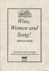
Programme - Program, Wine Women and Song!, c1999
... MONTROSE TOWN CENTRE Mt Dandenong Tourist Road, Montrose SHIRE... and Song! Programme MONTROSE TOWN CENTRE Mt Dandenong Tourist Road ...Black ink on cream card bookletMONTROSE TOWN CENTRE Wine, Women and Song! Programme MONTROSE TOWN CENTRE Mt Dandenong Tourist Road, Montrose SHIRE of YARRA RANGESjacqueline dark, jacqui dark, wine, women and song, music, yarra ranges, montrose -
City of Kingston
Photograph - Black and white, 3 March 1954
... aerial view includes Warrigal Road and Centre Dandenong Road... and Centre Dandenong Road intersection (top left); Charman Road ...Cheltenham and Moorabbin are suburbs within the City of Kingston that were originally established as rural market gardening communities The area is bordered by Highett and Mentone. The market gardens, farms and paddocks have gradually been sub-divided into housing and industrial estates. Highett is developed with residential homes but was also the site of major facilities such as the Highett Gas Works. This aerial image covers a diverse section of the City of Kingston, taking in the suburbs of Moorabbin, Cheltenham, Highett and Mentone Residential housing development is prominent along the Frankston Railway line and the area still retains extensive market gardens and paddocks yet to be converted to a large industrial and commercial zone.Aerial photograph of Mentone, Cheltenham and Moorabbin within the City of Kingston. The area depicted in this 1954 aerial view includes Warrigal Road and Centre Dandenong Road intersection (top left); Charman Road, Patty Street, Bourke Street, Collins Street Mentone (top right); Keys Road Moorabbin (bottom left); Bay Road, Cheltenham (bottom right), Friendship Square, Cheltenham Park, Victoria Golf Club and Jack Barker Oval are visible. Nepean Highway and the Frankston railway line run centrally through the image. Highett Gasworks is also evident.White handwriting and type [indecipherable]. White image of clockface White image of compass White type 42956 Black handwriting 3/3/54 Williams [indecipherable] Black pencil: S [arrow] Black ink: 3/3/1954cheltenham, moorabbin, mentone, highett, market gardens -
 Melbourne Tram Museum
Photograph - Black & White Photograph/s, early to mid 1940's
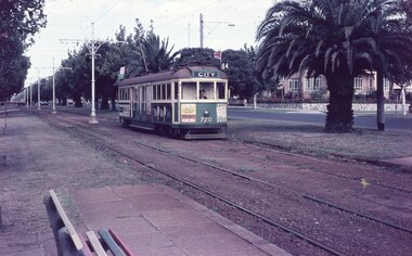
... Kilda, Acland St via Dandenong Road. Ceased in 1955. See Reg... Kilda, Acland St via Dandenong Road. Ceased in 1955. See Reg ...Black and white photograph of CW5 685 in Hawthorn Road with Caulfield Park in the background, just before Balaclava Junction. Tram has white strips on the bumper and under the cab windows. Photo during the early to mid 1940's. Tram has an Auxiliary board "Via Dandenong Rd" and showing, Route 67. At the time, Route 67 ran from St Kilda ran from Balaclava Junction to St Kilda, Acland St via Dandenong Road. Ceased in 1955. See Reg item 815 for details. See 6791 for a copy negative.trams, tramways, cw5 class, balaclava junction, hawthorn rd, route 67, tram 685 -
 Ballarat Tramway Museum
Album, Brian Andrews, UR1 - 300 Photo - Bendigo, Ballarat trams, 1968
... , the Hump, Royal Park, route 82, Dandenong Road, Glenferrie Road... - featuring Queensway, the Hump, Royal Park, route 82, Dandenong Road ...Album compiled by the photographer containing generally 89 x 124mm of: • Bendigo – 151 black and white prints • Ballarat – 119 black and white prints and some colour • Melbourne – 20 colour and black and white prints - featuring Queensway, the Hump, Royal Park, route 82, Dandenong Road, Glenferrie Road, Barkers Road and Hawthorn Bridge. • Rome, Hong Kong and Toronto – 14 prints See items 8638 to 8642 for negatives of the Ballarat and Bendigo photos and related image files held on the BTM Demonstrates the work of the photographer.Album - heavy plastic covered covers, with 100 sewn and glued paper sheets each side with three plastic sleeves for photographs with a negative pocket page at the rear. See list of btm8637 - Ballarat list.doc for a location listing of the Ballarat photographs.trams, tramways, ballarat, bendigo, melbourne, hong kong, toronto, rome, brian andrews -
 Melbourne Tram Museum
Negative - Copy - CW5 685 Hawthorn Road, Balaclava Junction, early to mid 1940s
... Kilda, Acland St via Dandenong Road. Ceased in 1955. See 3599... Kilda, Acland St via Dandenong Road. Ceased in 1955. See 3599 ...Black and white photograph of CW5 685 in Hawthorn Road with Caulfield Park in the background, just before Balaclava Junction. Tram has white strips on the bumper and under the cab windows. Photo during the early to mid 1940's. Tram has an Auxiliary board "Via Dandenong Rd" and showing, Route 67. At the time, Route 67 ran from St Kilda ran from Balaclava Junction to St Kilda, Acland St via Dandenong Road. Ceased in 1955. See 3599 for a poor print.Yields information about the use of L class trams.Copy negative of a black and white photographtramcars, tramways, caulfield, hawthorn road, cw5 class, balaclava junction, route 67., tram 685 -
 Melbourne Tram Museum
Document - Research Notes, H. S. McComb, "Extracts from the Minutes of the Prahran and Malvern Tramways Trust which was constituted under Act of Parliament No. 21030 in 1907", 1940's
... ., Dandenong Road lines, railway bridges, extension of High St to St...., Dandenong Road lines, railway bridges, extension of High St to St ...Original and carbon copy of "Extracts from the Minutes of the Prahran and Malvern Tramways Trust which was constituted under Act of Parliament No. 21030 in 1907", 10 foolscap sheets. Includes depot purchase, regrading of High St, extension to Burke Road, relocation of water mains, surveys, starting of construction, tenders for track and buildings, opening, extension, F. A. McCarty & Co., Dandenong Road lines, railway bridges, extension of High St to St Kilda Road, MMBW, finances. Items 2041 to 2052 within box 72.3 in a brown folder marked "PMTT" in red pencil.trams, tramways, pmtt, malvern, routes, track, surveys, malvern rd, tenders, construction, opening, dandenong rd, mmbw, finances -
 Ringwood and District Historical Society
Map, Plan of Country Lands in the Parishes of Nunawading Ringwood and Scoresby - circa 1855
... Mount Dandenong Road. (*Cemetery did not eventuate.)... and Sawmill Road, later Mount Dandenong Road. (*Cemetery did ...Blueprint copy of Survey Map detailing original Selectors' names and property locations. List of Parish map references including property bearings, distances in Links, and markings on trees. Descriptive remarks include areas marked "Farmer's Common", "Poor soil thickly/moderately timbered with stringy bark", and location of water and firewood reserves."Surveyed and plotted by N.M. Bickford, Superintendant of Mr. Hodgkinson's Field Party". "The land comprised in this survey is of inferior quality, moderately undulating, and thickly wooded. It is watered by Dandenong Creek and Deep Creek." Inset map showing location of (*proposed) cemetery on southern corner of Lillydale Road from Melbourne and Sawmill Road, later Mount Dandenong Road. (*Cemetery did not eventuate.) -
 Mt Dandenong & District Historical Society Inc.
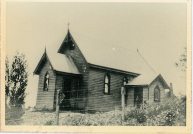
Photograph, Church of England, Olinda
... on to the main Mt Dandenong Road but the road was deviated... Dandenong Road but the road was deviated in and the main road ...Church of England. Monash Avenue, Olinda. The descriptive text on the reverse of this photograph was hand written by John Lundy-Clarke.Church of England Olinda When the church was built it faced on to the main Mt Dandenong Road but the road was deviated in and the main road section in front of the Village Settlement blocks was named Monash Avenue. The chapel built on Mrs Warner’s land on Mernda Road (later Coonara Road) was shifted in 1936 by Dick Mitlan using Jack Clarkes Ford truck as traction plant. church of england, olinda, monash avenue -
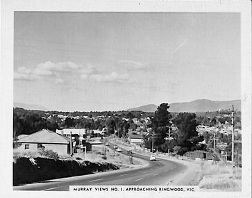 Ringwood and District Historical Society
Photograph/Postcard, Souvenir photograph - Murray Views No.1 - Approaching Ringwood, Vic
... towards Mt. Dandenong from Heatherdale Road along Maroondah... Road Ringwood North melbourne Black & white "Murray Views ...Black & white "Murray Views" souvenir photograph - View towards Mt. Dandenong from Heatherdale Road along Maroondah Highway, Ringwood. Circa 1950s. -
 Whitehorse Historical Society Inc.
Photograph, Jones Flower Farm
... the Dandenongs with Mitcham Road in middle distance.... the Dandenongs with Mitcham Road in middle distance. Jones Flower Farm ...Jones Family Collection - NP2565 to NP2606. See also ND3831.Black and white photograph of daffodils growing on Jones' Flower Farm in Mt Pleasant Road, Nunawading, looking towards the Dandenongs with Mitcham Road in middle distance.jones, bette, walter, rolf, geoffrey, arthur, keith, lionel, muriel, jones flower farm, mount pleasant road nunawading -
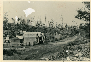 Mt Dandenong & District Historical Society Inc.
Photograph, Main Street Olinda c1908
... the picture right, Mt Dandenong Road goes down left. Range Road... Community Hall 42 Falls Road Mt Dandenong yarra-valley ...c1908 view of Main Street Olinda with Dodd's store in foreground and Olinda State School up on the hill. Reverse of photograph has handwritten description by John Lundy-Clarke.Photo of Olinda taken about 1908 showing State School on skyline. Dodd’s store in foreground. Hodges blacksmith shop on roadside right. Coonara Road, then Mernda Road leads up out the picture right, Mt Dandenong Road goes down left. Range Road (the bullock track) is in immediate foreground and Sassafras turns to the right before the visible tracks on Mernda Road.olinda, jack dodd, general store, school -
 Ringwood and District Historical Society
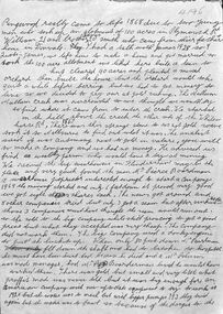
Document - Recollection, Unknown, Story of William and James Smith - Ringwood from 1868 to 1920, c.1950
... the corner of Mt Dandenong Road and Maroondah Highway, with the main... near the corner of Mt Dandenong Road and Maroondah Highway ...Single page handwritten notes by unknown author briefly outlining family history of William and James Smith in Ringwood from 1868 to 1920. Page ends mid-sentence however no trace of subsequent page/s. Further information on the William and James Smith and family (expanding on these notes?), is contained in the book " A History of Croydon - Second Volume" by Muriel McGivern (pages 170-176) +Additional Keywords: Smith, William / Smith, James / Boardman / Pierce / Robason / antimony William and James Smith were credited for discovering antimony ore near the corner of Mt Dandenong Road and Maroondah Highway, with the main mine later developed by Pierce Boardman. -
 Ringwood and District Historical Society
Document - Subdivision Map, Part of Crown Portion 22 Parish of Ringwood, County of Mornington. Vol 1915 Fol 827 - LP2427
... Road), Wandin Road (later Mount Dandenong Road), and Joseph... Road), Wandin Road (later Mount Dandenong Road), and Joseph ...LANDATA Land Victoria 4-sheet plan dated January 2003 - copy of original 1889 subdivision, amended with 1947 amendments by Assistant Registrar of Titles.Sheet 1 includes Main Lilydale Road (later Old Lilydale Road), Wandin Road (later Mount Dandenong Road), and Joseph Street, Ringwood East. Additional Plan markings SP30844, SP32804, LP144251, PS332061, PS305232. Sheet 2 includes Main Lilydale Road (later Old Lilydale Road), Wandin Road (later Mount Dandenong Road), and Dynes Street, Ringwood East. Additional Plan markings LP43708, LP44231, LP124702. Sheet 3 includes Main Lilydale Road (later Old Lilydale Road), Dynes Street, Albert Street (later Wyrunga Street), and Carcoola Road, Ringwood East. Additional Plan markings LP114181, LP114180, LP18261, LP214030, LP67300, PS354509, PS335500. Sheet 4 includes Main Lilydale Road (later Old Lilydale Road), Albert Street (later Wyrunga Street), and Carcoola Road, Ringwood East. Additional Plan markings PS315494, PS319495. -
 Whitehorse Historical Society Inc.
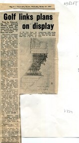
Article, Golf links plans on display, 1973
... Road and Dandenong Creek Vermont displayed at Nunawading... between Morack Road and Dandenong Creek Vermont Plans for the 145 ...Plans for the 145 acre South Vermont course between Morack Road and Dandenong Creek VermontPlans for the 145 acre South Vermont course between Morack Road and Dandenong Creek Vermont displayed at Nunawading LibraryPlans for the 145 acre South Vermont course between Morack Road and Dandenong Creek Vermontmorack golf course, south vermont -
 Bendigo Historical Society Inc.
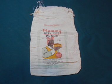
Textile - FLOUR BAG COLLECTION: WATSON MILLING, 1900-1950
... . Manufactured by WATSON Milling Co. Pty. Ltd. 1097 Dandenong Road, East.... Pty. Ltd. 1097 Dandenong Road, East Malvern, Se5 Phone UL3131 ...Textiles.Calico flour bag with the following printed on one side; ''Mammy'' oven puff, creamed self raising flour large bags, 25 lb net weight. When packed. Contains Vita-phos. The only creamed flour. Prepared with phosphate aerator. Manufactured by WATSON Milling Co. Pty. Ltd. 1097 Dandenong Road, East Malvern, Se5 Phone UL3131''. Centre front is a picture of an African-American lady holding a cake. Picture has a border of wheat sheaves. The boy has remnants of stitching used to close the top of the bag. Collection holds two other uncatalogued samples. 7lb bag has picture of three scones on one side.textiles, domestic, watson milling flour bag -
 Ringwood and District Historical Society
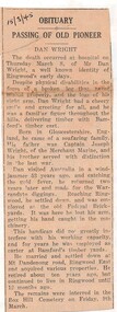
Newspaper - Obituary, Death of Ringwood resident, Dan Wright on March 8, 1945
... married and settled down at Mt Dandenong Road, Ringwood East... married and settled down at Mt Dandenong Road, Ringwood East ...Local newspaper clipping - 15/3/1945 - Passing of Old Pioneer.Born in Gloucestershire, England ... Settled in Ringwood and was employed at the old Federal Brickyards. It was here that he lost his arm, getting his hand caught in machinery. This handicap did not greatly interfere with his working capacity, and for years he was employed as carter at Bamford's timber yards. He married and settled down at Mt Dandenong Road, Ringwood East and acquired various properties. Interred Box Hill Cemetery on Friday, 9th March. -
 Melbourne Tram Museum
Slide - Set of 15 - Railway MMTB Tram shelters, Robert Green, 2/1990
... Streets 12 - Cnr Dandenong Road and Wattletree Road 13 - Victoria... - Cnr Dandenong Road and Wattletree Road 13 - Victoria ...Set of 15 colour slides of Tramway Board and MMTB tramway shelters, by Robert Green Feb1990. 1 - Macarthur St and St Andrews Place (Tramway Board) 2 - Macarthur St and St Andrews Place (Tramway Board) 2A - Macarthur St and St Andrews Place (Tramway Board) - logon on the shelter 3 - SW Corner of St Kilda Road & High St 4 - Cnr St Kilda Road and Dorcas St 5 - Batman Ave and St Kilda Road - removed with Batman Ave closed, now at the TMSV Bylands 6 - ditto 7 - ditto - shows the Bundy clock on the office wall. 8 - Victoria and Brunswick Streets 9 - ditto 10 - Cnr St Kilda Road and Bromby St 11 - Victoria and Brunswick Streets 12 - Cnr Dandenong Road and Wattletree Road 13 - Victoria and Brunswick Streets 14 - Bourke and Spencer Streets - note the Bundy clock. Behind is the MTOCo Offices and Carlyons Hotel.Yields information about Melbourne tramway shelters.Set of 14 Kodak colour slides in plastic mounts and one unmounted phtographAll slides have their location marked on them in black ink.tramways, shelters, tramway board, mmtb, macarthur st, st kilda road, brunwick st, batman ave, victoria parade, wattletree road, bourke st -
 Uniting Church Archives - Synod of Victoria
Award badge, Wittenbach & Co, Methodist Sunday School Windsor
... , then a small wooden building in Dandenong Road. In 1998 she..., then a small wooden building in Dandenong Road. In 1998 she ...Awarded to Mrs Eva Snow. Mrs Snow was born Eva Williams, on 5 August 1901, in Octavia Street, St Kilda. As a girl she attended the Windsor Methodist Church in Upton St with her parents, her sisters and brother. She also went to the Sunday School there. Her grandfather, Mr Kingham, was the Superintendent. If a student attended Sunday School for a full year without missing once, they were awarded a silver star. For 4 years perfect attendance the gold star with laurel wreath was awarded. Eva was awarded hers when she was about 11 years old. Eva moved to Murrumbeena with her family and joined the Methodist Church, then a small wooden building in Dandenong Road. In 1998 she was a member of St Giles Uniting Church, Murrembeena.B066 Star shaped with wreath behind award."METHODIST SUNDAY SCHOOL WINDSOR"methodist sunday school windsor, eva williams, eva snow -
 Melbourne Tram Museum
Slide - Set of 6, Keith Caldwell, 11/03/1960 12:00:00 AM
... Caldwell - all dated 11 March 1960 .1 - W5 720 inbound Dandenong...Melbourne Tram Museum 8 Wallen Road Hawthorn melbourne ...Set of six Agfa Colour slide, cardboard mount, by Keith Caldwell - all dated 11 March 1960 .1 - W5 720 inbound Dandenong Road, route 64, City, with advertisements for Tek toothbrushes, Bridge and Webster, auto electrical and Band aids. .2 - W2 573, showing St Kilda Junction, no route number. Tram has adverts but not easily read. .3 - SW6 947, showing route 62, city. Has adverts for Qantas and ? soap. .4 - W5 816, showing route 5, city, with adverts for Ducklings, Champion Spark plugs and Ferris car radios. .5 - W2 398, as for .4, with adverts for Remy Martin Brandy and 3AW. .6 - SW6 958, as for .1, followed by 833?. The first tram has adverts for Persil soap powder? and 3AWhand stamped "11 Mar '60". .5 has "W2" in ink.trams, tramways, dandenong rd, w5 class, route 64, w2 class, st kilda junction, sw6 class, route 62, route 5, tram 720, tram 573, tram 947, tram 816, tram 398, tram 958 -
 Phillip Island and District Historical Society Inc.
Memorabilia, Phillip Island Memorabilia
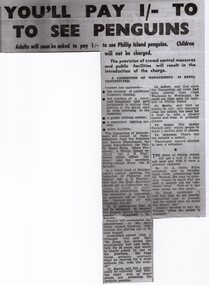
... & 2 - Cowes - Dandenong Road Service showing Daily Road Route... House, Phillip Island 1162-05 Pg 1 & 2 - Cowes - Dandenong Road ...Items used in Research for Book - "Penguin Land" by Gregor BuchananHistorical1162-01 Article from the Wonthaggi Express - Penguin Parade Admission 1162-02 Brochure called "The Short Way to Cowes" detailing taking the train from Flinders Street Railway Station, Melbourne to Stony Point then by Ferry to Cowes 1162-03 Pg 1 & 2 - Souvenir Programme "Music for the People" to be held weather permitting on the Cowes Foreshore at 2pm February 20th, 1955 1162-04 - Card - Drawing of a Fur Seal - one of the 5000-odd Seals on Seal Rocks, as seen from The Nobbies Road House, Phillip Island 1162-05 Pg 1 & 2 - Cowes - Dandenong Road Service showing Daily Road Route and connection from Dandenong to Flinders St. Melbourne. Time Table to and from Cowes to Dandenong"penguin land" book, gregor buchanan, seals, ferry, stony point to cowes, cowes to dandenong, penguin parade, variety concert ticket, tourism -
 Mt Dandenong & District Historical Society Inc.
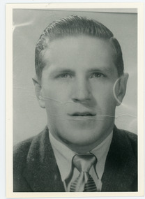
Photograph, Alan Price
... Dandenong Road.... Community Hall 42 Falls Road Mt Dandenong yarra-valley ...John Lundy-Clarke grew up in the Kalorama/Mt Dandenong area and later in life (1972-74) began to write a comprehensive history of the district working from an original settlement map in an effort to cover all areas. Alan Price was the son of Edward John Price and Myra (nee Wilson) Price. He had a brother Edward Joseph 2nd (Teddie). Alan and Teddie were the grandsons of early settlers Edward Joseph and Annie (nee Ross) Price. Alan Price worked at his brother's depot in Ringwood, in charge of mechanical equipment. He rode to and from work on his motorbike. Alan was killed in a motorbike accident on his way home from work in 1971. Alan married Patricia Guerin in 1960. They had five daughters and one son. The family had a house on part of Lot 5 facing Mt Dandenong Road.Black and white close up of man in suit and tie. Reverse of photograph has handwritten description by John Lundy-Clarke. Alan Price 1969. Son of Edward John Price and Myra nee Wilson. alan price, patricia guerin, edward joseph (teddie) price, edward john price, myra price, myra wilson, edward joseph price, annie price, annie ross, kalorama, accident