Showing 518 items
matching early settlement.
-
 Flagstaff Hill Maritime Museum and Village
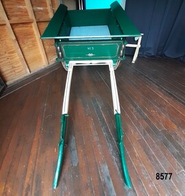
Vehicle - Tip Dray, Prior to 1930s
... the early days of settlement. In Australia in the early 1900's... the early days of settlement. In Australia in the early 1900's ...A Dray is a type of dead axle wagon that was used to transport heavy loads or objects. They had a flat level floor and while some had no sides, others had box bodies and sides. Tip Drays (also known as Tip Carts, Muck Cart, Scotch Cart, Tumbrel or Putt in different parts of England) were smaller than other drays as their loads were heavy and usually only pulled by one horse. Their basic design included two wheels, a tipping body and shafts. The Tip Dray has a unique mechanism that allows the top to tip backwards to tip the load out of the back of the dray. The tipper was activated by a handle at the front allowing the driver to operate it while still having control over the horse. A Tip Dray was an indispensable piece of equipment in the days before tractors and mechanical trucks. They were used by farmers and carters to transport hay, rocks, bricks, gravel and rubbish etc. and because they were useful for dumping loads, they were favoured for use in road and railway construction. A photo in the collection of the Lorne Historical Society shows a tipping dray being used during the construction of the Great Ocean Road. They were part of the daily street traffic in towns and cities around Australia from the early days of settlement. In Australia in the early 1900's, carters began to join unions to protect their jobs and pay. N.S.W. had a "Trolley, Draymen and Carters Union", Queensland had a "Tip Dray Men's Association" and in W. A. the "Top Dray Driver's Union" had a "cessation of work" in 1911 when they were fighting for an increase in their day's wages. In 1910 a meeting of Tip Carters was held in Geelong at the Trades Hall to discuss the formation of a union (The Geelong Tip Dray Carters) which was a success and a schedule of rates for all carting, whether by contract or day labor, was fixed. By 1912 they had "labelled" more than 50 drays and had representatives on the "Trades Hall and Eight Hours Committee". By the mid 1930's and early 1940's, tip drays were being superseded by mechanical trucks and utes. However tip drays continued to be used in some circumstances. They were a practical solution to the problem of petrol rationing during W. W. 2. It was noted in a letter to the editor in the "Sunshine Advocate" in 1938 that a positive argument for continued use of Tip Drays for rubbish collection related to the idea that a horse drawn vehicle involved with lots of stops and starts at different houses (very like a milkman's delivery route) often involved the horse "driving itself" while the driver picked up the rubbish - something a motor truck was unable to do! Another article written in August 1935 and published in the Age in a parliamentary report into the rubber industry noted "tip drays had almost disappeared and in their place, metal was carted in 5 ton motor trucks" but the report went on to say that as a part of the Government relief work (during the Great Depression) the Government had "to some extent reintroduced the tip drays so that a greater number of men would be employed". This particular tip dray was owned by Mr. Oswald (Jack) Bourke. He used it to deliver dry goods from Sunbury to the Queen Victoria Market in Melbourne several times a week in the 1930's and then (between 1945 and 1962) Mr. Bourke used it on the garbage round in Springvale Victoria for the Springvale Council. The Council owned three drays and the "No. 3" painted on this dray is in recognition of its original number. After the death of Mr. Bourke in 1990, one of Mr. Bourke's sons (Andy) found the dray in a shed and restored it. The sign writing on the back and side panels were added during the restoration. This Tipping Dray is a significant example of a horse drawn vehicle that was used by workers from the early days of white settlement through to the 1940's and even into the early 1960's. It was used in a range of "working class" occupations - road construction, railway construction, carting goods, rubbish collection etc. and would have been found in cities, country towns and on farms.A wooden and metal tipping dray with a box body and four sides. It has two iron and wooden wheels (with 14 spokes), two wooden shafts and a metal tipping mechanism. The back panel folds down to allow loads to be dumped out. It is painted in green and cream with sign writing on one of the sides and on the front and back panels. It features decorative painted lines and designs in burgundy, cream and light blue on most of the wooden parts. The tipping mechanism is on the front of the dray's left side and consists of a metal pin secured with a metal ring, and a lever.Front of dray - "No. 3" Side of dray - "A. & M. BOURKE / Contractors / LONGWARRY" Back of dray - "G.T. ANDREWS / QUEEN VICTORIA MARKET - Stand C23 / Phone DANDENONG 225"flagstaff hill maritime museum and village, warrnambool, shipwreck coast, tipping dray, dray, tip dray, tip cart, vehicles, horse drawn vehicle, springvale council, jack bourke, muck cart, scotch cart, tumbrel, putt, box body, oswald bourke, sunbury, queen victoria market, melbourne, no. 3 -
 Eltham District Historical Society Inc
Photograph - Digital Photograph, Alan King, Kangaroo Ground General Store, Eltham-Yarra Glen Road, 28 December 2007
... life. In the settlement’s early days a previous general store... life. In the settlement’s early days a previous general store ...The present store was built circa 1900 to replace another which had been destroyed by fire in 1898, which had replaced a predecessor on the opposite side of the road in 1865. The store was also used as a post office until early 2000s. The general store is historically significant because it has a long association with Kangaroo Ground and has been an important centre of community life for more than 120 years - Council meetings used to be conducted in the front room of the store at a time when Kangaroo Ground rivalled Eltham as the major centre of the Shire. The general store is historically and aesthetically significant as one of a group of three well preserved public buildings in the Kangaroo Ground hamlet and as a major heritage component of Kangaroo Ground which was one of the earliest settled areas of the Shire and which has the character of an English village rather than an Australian settlement. Covered under Heritage Overlay, Nillumbik Planning Scheme. Published: Nillumbik Now and Then / Marguerite Marshall 2008; photographs Alan King with Marguerite Marshall.; p77 Today the general store is an uncommon form of trade but the one at Kangaroo Ground continues a long tradition of friendliness and service. For more than 100 years it has been a centre of community life. In the settlement’s early days a previous general store, on the same site, was the meeting place for the Eltham District Road Board, precursor to the Eltham Shire Council. For years Kangaroo Ground rivalled Eltham as the shire’s major centre. It developed very differently from the rest of the shire as its rich soil attracted prosperous Presbyterian Scots who had large agricultural properties.1 The present store was built to replace another one, which had burnt down in 1898, after replacing a predecessor on the other side of the road in 1865. The store retains its outward character and its cellar, although inside it has changed considerably. It now includes a café and offers local produce, milk bar products, grocery items, gas and other fuel. Until early this century the store was also used as a post office. Kangaroo Ground’s first postmaster was Andrew Ross, who first operated from the school opposite, then from his hotel next to the present tennis court site. The first postmaster at this store was Edward Weller, followed in 1868 by James Anderson. At that time a mail coach ran three times a week between Eltham and Woods Point through Kangaroo Ground, Yarra Flats, Healesville, Fernshaw, Marysville and Matlock. Some early postmasters were Rodger, McLaughlin, Greenway and Burns.2 Burns was the only postmaster operating from the store. The others operated from Andrew Ross’s hotel. The mail service improved in 1892 when coaches ran from Melbourne to Queenstown (now known as St Andrews) and changed horses at Kangaroo Ground twice daily. The only telegraph office in the district at that time was at the Kangaroo Ground Post Office. Telegrams to outlying areas such as Queenstown and Kinglake had to be sent by hand. A local resident in the early 1900s often rode his pony to deliver telegrams and was paid one shilling a mile porterage. The store has also contributed to the lighter side of Kangaroo Ground life. During the years that Con Wraight owned the store, between 1906 and 1946, a new piano was needed for the Kangaroo Ground Hall, so monthly dances were held to raise money. When the piano was bought, a grand ball was held in the Kangaroo Ground Hall to celebrate the occasion and supper followed at Mr Wraight’s barn, cleaned especially for the occasion. Every New Year’s Eve, a Scottish piper would set off from between the store and the schoolhouse, playing his pipes, and march to Cameron’s Pigeon Bank homestead on the Kangaroo Ground-Warrandyte Road. Between 1914 and 1922, the store was a station for the Kangaroo Ground Bush Fire Brigade’s tanker. It consisted of a wooden barrel on a cart, fitted with a hand-pump, and stood on the side of the road outside the store. Joy Ness, who belonged to an early Kangaroo Ground family, moved here in 1940 and recalled her impressions of the store at that time: ‘It was a very dark shop stained in a dark colour and on the walls just below the ceiling hung hurricane lamps, ropes, kitchen utensils and other goods for sale. ‘Goods were weighed on a brass scale with weights, on which mothers also weighed their babies, because the nearest Infant Welfare Centre was at Greensborough. The bacon was cut with a hand slicer and later a pot-bellied stove warmed the store. Farmers and other locals used to gossip around it as they collected their daily mail. In those days the butter and cheese were kept in the cellar as no ice was delivered for cooling.’This collection of almost 130 photos about places and people within the Shire of Nillumbik, an urban and rural municipality in Melbourne's north, contributes to an understanding of the history of the Shire. Published in 2008 immediately prior to the Black Saturday bushfires of February 7, 2009, it documents sites that were impacted, and in some cases destroyed by the fires. It includes photographs taken especially for the publication, creating a unique time capsule representing the Shire in the early 21st century. It remains the most recent comprehenesive publication devoted to the Shire's history connecting local residents to the past. nillumbik now and then (marshall-king) collection, eltham-yarra glen road, kangaroo ground general store -
 Melton City Libraries
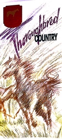
Pamphlet, Thoroughbred Country, c.1985
... and racing. Draught horses were a crucial aspect of life in the early... and racing. Draught horses were a crucial aspect of life in the early ..."Melton has a long and celebrated history of horse breeding and racing. Draught horses were a crucial aspect of life in the early days of European settlement, and were heavily depended upon for both transport and agricultural labour. Peppercorn trees at the corner of Station and Brooklyn roads have been associated with a horse trough installed there to provide a drink to workhorses carting produce to the chaff mills and railway station south of Melton.20 Breeders, trainers and harness drivers in the area later became such an influential force in the equine industry that this came to be a defining aspect of the district’s identity and reputation.Pioneer of the Victorian horse racing industry and early Rockbank squatter William Cross Yuille was one of the earliest importers of stud racehorses in the district in the 1850s. A leading sports editor and writer, Yuille established bloodstock auctioning agency W. C. Yuille & Co. and was involved in the compilation of the first Australian Stud Book, which ensures the integrity of thoroughbred breeding in Australia. According to early Melton chronicler Alexander Cameron, horse races were first organised in the area by Rockbank farmer William Keating. Keating owned racehorses of his own, and many brought horses from Melbourne for the events, which ‘drew large gatherings’.22 Melton Racing Club meetings were held on the Exford Estate with the permission of H. W. Staughton, who built a small wooden grandstand in 1882. Other early races and sports meetings are said to have been held in the vicinity of the current-day Melton golf course.23 An 1884 article reported that Melton’s ‘race programme … equals any put forth by country towns of far greater size’. Ernest Clarke was another important figure in the early horse racing industry in Melton. He established the Melton Stud in 1902, which bred numerous successful racehorses. Perhaps most notably The Welkin, one of the most famous stallions in Australian horse racing in the early twentieth century. The Welkin sired Gloaming, bred by Clarke at the Melton stud in 1915 and one of Australia’s greatest champion racehorses. During a long and prestigious career in both Australia and New Zealand, Gloaming achieved a triumphant 57 wins out of 67 starts and won a record amount of prize money. Ken Cox purchased the Stockwell Stud in Diggers Rest in 1957 and developed it into one of the largest and most renowned thoroughbred breeders in Australia. With its top-class facilities, international design standards and scientific methods, Stockwell became ‘the flagship of the Victorian breeding industry’.26 As well as racing studs, numerous trotting tracks were established on the flat plains around Melton in the 1960s.27 Other studs to play a leading role in the development of Melton as thoroughbred country were Cornwall Park and Merrywood at Toolern Vale, St John’s Lane Stud at Diggers Rest and Birchwood, Teppo Park and Dreelburn in the far north-east of the shire, near Sunbury. By 1985, thoroughbred horse breeding was such big business in Melton that the shire council adopted the slogan ‘The Heart of Thoroughbred Country’, which was used throughout its promotional material.29 But the slogan contained deeper meaning and was not just about Melton’s great equine industry and thoroughbred champions, the council explained: ‘“Thoroughbred Country” should be seen as a new concept of Melton, as a place where people can achieve the “Thoroughbred” ideal, excellence in all aspects of life’. The aim of the council in promoting ‘The Heart of Thoroughbred Country’, was ‘to instil in present and future residents the feeling that this is a place that is better than others. A place to be proud of’. In 1988, Melton’s champion reinsman Gavin Lang won his 176th race of the season, claiming the national harness racing record for the most wins in a single season.The following year, the first Melton Plate was held at Moonee Valley Racecourse, cementing the district’s importance in the harness racing industry. The inaugural winner was Victorys Phil, owned by local Danny Mullan. By the 1990s, Melton had earned the title of the ‘Home of Harness Racing in Victoria’. State-of-the-art, world-class harness racing facility and entertainment complex Tabcorp Park opened in Melton in 2009. In 2011, the Shire of Melton was home to over 140 registered trainers and over 1,200 horses. The municipality’s continuing leadership and influence in the industry today is a testament to the skills, talents and leadership of the local community over its history".Shire of Melton pamphlet of a map and information of the equine industry in Meltoncouncil -
 Federation University Historical Collection
Document, Zelda Martin, Central Victorian Goldmining towns - Boom Towns or Ghost Towns?, c1996
... , Local Government and Early Settlement. [.3] 6th item in Light..., Local Government and Early Settlement. [.3] 6th item in Light ...Zelda Martin was a PhD candidate at the University of Melbourne.[.1] 4th item in light blue display book titled Research Approach/Overview of Chapters/Confirmation of Canditure/Chapters1,2,3&4 of proposed thesis. *Twenty-seven page article on Victorian goldfields towns titled: Central Victorian Goldmining Towns - Boom Towns or Ghost Towns. The article was written during the author's PhD study. It outlines the context methodology, and resources and the chapters of the proposed thesis: (1) Central Victorian Goldmining Towns - The Context (2) Contemporary Views of the Factors Necessary for Town Growth (3) Outward Manifestations of Town Growth (4) The Trappings of Government (5-9) The Main Towns and Their Hinterland. [.2] 5th item in Light Blue display book as above item. *Chapter 1 of proposed thesis titled 'Pick, Shovel and Tin Dish Mining.' Covers in Section A: Central Victoria - Pre 1851: Aborigines in Central Victoria, Squatters, and Government. Section B: The years 1851-1854: The Early Gold Rushes, Government Reaction, Township Surveys, Legislation, Town Development, Local Government and Early Settlement. [.3] 6th item in Light Blue display book as above item. *2A of proposed thesis titled 'Contemporary Views of the Factors Necessary for Town Growth'. Similar information to Chapter 1 plus extra re towns and maps. Sections: Introduction, Context of Place - Geographical Towns Listed, The Context of Time - Pre1851 Aborigines, Governance of Port Phillip, The Squatters, The Villages of Central Victorian Highlands, Conclusion, Condensed Version of Chapter2B. [.4] 7th item in Light Blue display book as above item. *Chapter2B of proposed thesis. Sections: Area of Research, Schools, Banks, Newspapers, Progress Association, Town Development - Sandhurst (Bendigo), Ballarat, Castlemaine,, Maryborough, Ararat and Stawell. [.5] 8th item in Light Blue display book as above item. *Chapter 3 of proposed thesis titled 'Outward Manifestations of Town Growth'. Sections: Introduction, Contemporary Writing, Educationalists, The Bankers, The Townsfolk, Current Theory, General Theories of Urban Development, and Conclusion. [.6] 9th item in Light Blue display book as above item. *Chapter 4 of proposed thesis titled 'Trappings of Government' Sections: Introduction, Early Government Attitudes to Mining and Town Development, Law and Order, Township Surveys, Legislation, Local Government, Transport and Communication, The People and Lobbyists. [.7] 10th item in Light Blue display book as above item. *'The Rise and Fall of Central Victorian Goldmining Towns'. Includes a map showing main Goldfields, a table showing towns and villages at two points in time - 1857 and 1871; a Bibliography of Primary and Secondary Sources. [.8] Resource No1. Black display book titled Local Towns 1 : Alma: *Brief history *Directory *Maps Amphitheatre / Mountain Hut: *Brief History Post Office Directory Ararat: *Brief History *Post Office Directory 1869 - Alphabetical Listing by Occupation *Ararat - Prominent Citizens of 1858 *Langi-Morgala Museum Avoca: *Brief History *Excerpts from 'Avoca The Early Years', Margery and Betty Beavis; pg1 - Beginnings; pg11 - The Midas Touch; pg25 - Local Gold Escorts; pg27 - A Town is Born; pg51- The Administration of Justice; pg53 - The Ways of the Law; pg61 - News of the Day; pg65 - A Time to Play; pg72 - Land Ownership *Post Office Directory (Bailliere's) 1869 *Tourism Map and Information of area *Historic Avoca - A 5.5km Tour *Avoca & the Pyrenees Region - information pamphlet Ballarat: *Early History of Ballarat - Ballarat Historical Society, Publication No.1: origin of the name; Ballaarat - the Beginning; Fabulous Yields from the Ballaarat Goldfield; *Streetscape Lydiard Street. *Hand drawn map showing Leigh River, Old Portland Bay Road, plaque on road to Colac; etc. *Newspaper article re 'The Theatre Royal' ( which stood in the vicinity of the current Owen Williams store) - 'The News'15/04/1998 *Article - 'Ballarat's Mechanics' Institute Lives On' Ballarat Courier, 14/09/1985 *Article - Standing the Test of Time' The News 17/11/1993 re The Mechanics Institute & picture of the Reading Room *'Ballarat a Study of a City, Phyllis Reichl, pub. Nelson, 1968; no.3 place, time and people field studies series *Investigator Vol.33 No.2, 1998 Geelong Historical Society. Article on pg75 describes Ballarat in 1861 *Folded poster - 'Ballarat 100' a history of telegraph communication, pub. Telecom. Beaufort (Fiery Creek): *Brief history *Post Office Directory [.9] Resource No.2 Black Folder Titled Towns cont.No2 Bendigo (Sandhurst): *'Family & Local History at the Bendigo Library - 1851-2001 150 years of gold'. *Bendigo Government Camp in 1853 illustration; key to sketch and names of Government officers stationed there *Excerpts from 'Bendigo and Vicinity' Adolph Haman *The Bendigo Goldfield Registry - pgs 1-7 Introduction *Excerpt: 'Breaking the Grip' *Excerpt: The Most Go-Ahead Place *Excerpts from 'History of Bendigo' - anti license agitation; laying out of town; proposed railway; gold calls and dividends; the Sandhurst Municipality; journalism *Bibliography Blackwood: *Excerpts from 'Aspects of Early Blackwood - The Goldfield, the Landmarks, the Pioneers' Alan J Buckingham and Margaret F Hitchcock, JG Publishing,1980 Buninyong: *A Brief History *Investigator Vol1 No.2 Feb 1966 Geelong Historical Society. Pg3 - Article re gold escort route - Mt Alexander to Adelaide - (see a simple monument on the Western Highway a few miles out of Horsham. Pg 15 - Ballarat Excursion - re the finding of gold. *Three articles published by Buninyong and District Historical Society Inc: (Magpie Exploration; Finding Gold In The Green Hills; Magpie Exploration; Burnt Bridge to Cargarie to Mt Mercer) *Copies of newspaper articles/items *Buninyong Street Directory Carisbrook: *In the Beginning There Was Carisbrook *The History of the Carisbrook Racecourse Carngham / Snake Valley: *Brief History *Directory Castlemaine: *Directory 1865-1866 - Alphabetical and Street *Poster - Castlemaine A Contemporary Guide "The Great Centre" 1866 - A Contemporary Guide to the Fascinating Past *Pamphlet - Castlemaine District Community Hospital *Map - Castlemaine, Maldon & Surrounding Districts *Map and Information - The Dry Diggings Track - a 55kl walk among historic goldfields relics ( Castlemaine Fryerstown Vaughan Mt Franklin Hepburn Daylesford) *Postcard - Former Court House *Directory 1867 - Alphabetical, Trade [.10] Resource No.3 Grey folder Titled Towns 3 Creswick to Maryborough Creswick: *Brief History *Booklet - "Creswick Cemetery Walk" *Booklet - The Buried Rivers of Gold Heritage Trail Creswick *Creswick Historical Museum Information Sheet *Chronological History of Creswick *Alphabetical Directory of the Borough of Creswick *Creswick's Creek Directory 1856 *Historic Creswick Walking Tour *A Brief Account of the Schools of Creswick - Past and Present *100 Years of Railway Travel in Creswick *The Berry Deep Leads *The Spence Home at Jackass Gully in the Creswick State Forest ( William Guthrie Spence - Pioneer) *The New Australian Mine and the 1882 Disaster *Creswick District News, Issue 7, July August 1999 *The Creswick Miners Walk - Information and Map *Maps Chewton: *Brief History *Directory Clunes: *Brief History *Clunes Street Directory Daylesford: *Brief History *Notable Bushfires in Daylesford District Over More Than a Century - "Black Thursday" 1851; 1862; 1899; the Disastrous Hepburn Fire of 1906; 1939; 1944; 1969. *Post Office Directory -Daylesford and Hepburn Dunolly / Inkerman: *Brief History *Directory *Pamphlet - Goldfields Historical Museum *Pamphlet - Historic Dunolly - Victoria's Best Kept Secret *Map of Gold Workings at Dunolly Area - showing where the main gold rushes occurred *Brief History - Inglewood *Directory - Inglewood - Name Occupation, Dwelling Kingower: *Brief History *Directory - Name / Ocupation / Dwelling Linton / Happy Valley / Piggoreet: *Brief History *Directory - Lintons McIvor: *"A History of the Shire and the Township of Heathcote" by J.O. Randell Majorca: *Brief History *Official Post Office Directory 1869 - Name / Occupation/ Address Maldon (Tarrangower): *Brief History Part 1 *Brief History Part 2 *Post Office Directory *List - Alphabetical Order by Names plus Business and Trade (Tarrangower Times Oct/1858) *List - Alphabetical Order by Trade plus Name and Business *Directory - Name / Occupation / Dwelling Maryborough: *Worsley Cottage - built by Arthur Worsley, a contractor in stonework in 1894 [.11] Resource No. 4 Blue Display Book titled Towns 4 Moliagul to Stawell Moliagul: *Brief History *Moligul Legislative Assembly (Voting?) List - Names and Occupations *Moliagul Victorian Post Office Directory 1868 - Name / Ocupation / Address / Comments *"The Welcome Stranger" gold nugget *The Sunday School *The Welcome Stranger Discovery Walk - information and map Moonambel (Mountain Creek) Redbank *Brief History *List of names extracted from advertisments of the Pioneer and Mountain Creek Advertiser 16/02/1861. *Bailliere's Directory 1869 - Alphabetical List of Name / Occupation / Place St Arnaud: *Brief History Sebastapol: *Brief History *Directory 1869 - Alphabetical by Name; plus occupation and address. Browns and Scarsdale: *Brief History *Browns Street Directory - Name and Occupation Smythesdale: *Brief Description *Smythesdale Street Directory -Name and Occupation Stawell (Pleasant Creek) *Brief History *Victorian Official Post Office Directory - Name /Occupation / Dwelling *Chronology - 1841-1920 *Production of gold statistics - 1879 - 1900 *Big Hill *Extracts from "The Golden Years of Stawell". Chapt 1 - Stawell's Coming Out. Capt. 2 - The Gold Rush. Caapt.3 - Cradle of Democracy. Chapt.4 - The Reefs Becomes Stawell. Chapt. 5 - Rushing In. Chapt.6 - The Pioneers. Chapt 7 - The Decade of Optimism. [.12] Resource No. 5: Blue Display Book titled 'Towns Steiglitz to the The Golden Triangle. Steiglitz: Brief History Victorian Post Office Directory 1869 *Map of Steiglitz *List of maps relevant to Steiglitz history *Information 6 tables of data from "Reports of Mining Surveyors Talbot (Back Creek) Brief History Taradale: Post office Directory 1869 - Name/Occupation/Street. Also list in alphabetical order by Occupation Taradale *Chronological Reference to Taradale Mines *Water - The Coliban System of Waterworks *Joseph Brady *The Syphon Tarnagulla (Sandy Creek) *Brief History *Tarnagulla Businessmen Cameos to give depth to advertisments in 'The Tarnagulla Courier' various issues 1864-1871 *Directory - Name/Occupation /Address *List - Name/Business/Trade Wedderburn (Koorong) *Brief History *List - Name/Occupation The Golden Triangle: *The Early Rushes - Wedderburn / Moliagul / Sandy Creek - Tarnagulla / Jones Creek - Waanyarra / Kingower / Dunolly - Goldsborough / Inglweood *Census of 1857 - Population / Occupations *1858-1871 - A Time of Consolidation- Wedderburn / Moliagul / Sandy Creek- Tarnagulla / Arnold *Census 1871 - Population *Information gleaned from the census data - Demographics / Population / Occupations / marital / Birthplace / Religion / Literacy/ Occupation and Housing Cameos *Graphs - Birthplace of settlers /Male-Female Ratio / Married males / Children under 15 as Percentage of Population / Religion *Census 1857 - Statistical data *Maps *Bibliography [.13] Resource No. 6 - Black Display Book Information and Research in Central Victoria including: *Banking - Research from ANZ Bank Archives *Institutions - also includes articles listed from the Ballarat Times Newspaper *Australian mining History Association - A.M.H.A. Bibliography *Australia's Mining History * Bibliography - Land Surveys Victoria - *1853 Administration (Statistics and Other) includes: schools / ministers of religion / police / military / local administration / licences for sale of spirits / distances between various Victorian gold fields. * Victoria Government Gazette (Copy) - N0. 116, 12/12/1854 includes: Gold Felds Commission of Enquiry & No. 85, 15/09/1854 - Addresses presented to the Lieutenant Governor (Sir Charles Hotham) during his tour through the Gold Fields of Victoria,1854. Addresses on behalf of : the people of Bendigo; Members of the Church of England, Bendigo; Members of the Wesleyan Church on the Bendigo Gold Fields; Bendigo Gold District General Hospital; the Bendigo Prospecting Association; Committee of the Bendigo Local Exhibition; Bendigo District Medical Association; Coloured Americans Resident at Bendigo; German Inhabitants of Bendigo; Landowners, Inhabitants, and Miners of Castlemaine; Inhabitants of Forest Creek; Inhabitants of Heathcote and Gold Miners of McIvor; Residents and landholders of the District of Bacchus Marsh; Inhabitants of Kilmore and Vicinity. *Gold Fields Correspondence 1853: letter from Lieutenant Colonel Valiant, (Officer commanding the Troops in Victoria) to the Lieutenant Governor re threatened disturbance at Sandhurst (Bendigo) regarding the Gold License Fee. * Extracts from a book "Victoria" re Gold Fields Commission of Enquiry involving mainly Ballarat and Castlemaine and a chapter titled 'A Tour to the Victorian Gold-Fields' *Lists of central Victorian newspapers - listed by date published 1851to 1874; by first date available to State Library. *A list of cities and towns showing County, population in 1861 &1871, and municipal status. [.14] Resource no.7. Black display book. *Reference: Papers presented to Parliament Victoria - 1859-1860 4 volumes - relevant sections copied. Contains information on Branches of Government. General / Finance / Gold / Gazette / Commission and Warrant / Statistic. *Gold Fields Act. In accordance with the Act the gold fields are divided into six districts - Ballaarat, Castlemaine , Sandhurst, Avoca, Ararat, and Beechworth.. Official staff in each gold district consists of a Resident Warden, Wardens, Wardens' Clerks, Bailiffs, Chinese Protectors, Chinese Interpreters, and Mining Surveyors. *Gold Receiver *Gaols *Police magistrates and Clerks of Petty Sessions, etc. *Field Branch *Immigration and Emigration Overland - Chinese - 1859 *Population on the Goldfields *The Geological Survey - The Government Geologist is assisited by staff from four branches - the office Branch; the Publishing Branch; the Field Branch and the Museum Branch. *Commission to Enquire Into Sludge dated 10/02/1859 (Some sections copied) - Report to the Honorable Chief Commissioner of Public Works, Melbourne re the mode of carrying the sludge from the puddling mills in Sandhurst without interfering with the drainage of the town and the roads in the neighbourhood. [.15] Resource No.8: Camel display book titled Resource No. 8. Aborigines *Lists of book titles - +"Readings in Victorian prehistory" +"The Aborigines of Port Phillip" +Aboriginal languages and clans" +"A History of the Port Phillip District" +"Langi Ghiran 1: Aboriginal Rock...." +"Koorie History: sources for aboriginal studies in the State Library of Victoria", ed. Tom Griffiths, Melb. Friends of the State Library, 1989 +"The Public Lands of Australia Felix"; settlement and land appraisal in Victoria1834-91 with special reference to the Western Plains", J.M.Powell, Melb. Oxford University Press 1970 +*Bibliography of the Victorian Aborigines' from the earliest manuscripts to 31st December 1970, Massoa, Aldo, Melb. Hawthorn Press, 1971 +"Aborigines in Colonial Victoria, 1836-1886", M.F. Christie, Sydney University Press, 1979 +"Urban and Industrial Australia: readings in Human Geography" ed J.M. Powell, Melb. Sorrett Pub. 1974 *Extracts: -Processes of Pioneer Settlement - The Squatting Occupation of Victoria, 1834-60. J.M. Powell -Areal Variations in the Class Structure of the Central-Place Hierarchy. P. Scott - Volume1 and Volume 2: Notes Relating to the Habits of the Natives of Other Parts of Australia and Tasmania. Compiled from various sources for the Government of Victoria by R Brough Smyth. John Curry, O'Neil, Melb. 1st pub. Melb. 1876. p31-45 - Numbers and Distribution of the Aborigines in Victoria -Victorian Aborigines 1835-1901 - A Resource Guide to the Holdings of the Public Record Office, Victoria; published by the Government Information Centre 1984. *History of the Aboriginal Artefacts Displayed in the Daylesford Museum. F. G. Powell (4 page pamphlet) *Letter to Zelda Martin from Peter Lovett, Cultural Officer, Ballarat & District Aboriginal Co- Operative, 05/02/1997 *Map: Ian Clarke Victorian Tribunal Boundary Map - Clans of Central Victoria. *Victorian Rock Art and Mythology - Article about Mount Langhi Ghiran and myths of the Tjapwarong people. *Two Aboriginal myths relating to the Grampians - 'The Monster Emu' / 'The Aquisition of Fire', by the Aborigines in the Grampians Areas *Article titled (chapter 8) Ballarat - information re camping sites in the region. Lake Wendouree / Lake Burrumbeet (includes a myth) / Mt Bunninyong / Lal Lal / Pitfield / Mount Elephant / Mount Egerton / Meredith / Lake Goldsmith / Lake Learmonth / Ercildoune *Notes on the Aborigines of the Wider Ballarat Region plus European names=Aboriginal names. John Morris 26/07/1995 *Role of Aborigines in Town Development in Central Victoria. Mentions Native Police Force est. in Port Phillip 1842 and Central Board for Aborigines est. 1860 *The Grave of King Billy. (Frank Wilson) Pamphlet. *Camping Places in Central and Northern Victoria. Article re Lake Burrumbeet site. *Programme for the Unveiling of Memorial Cairn for Edward Stone Parker 1802-1865. Note portrait not accurate. Accurate portrait is available in the book "A Successful Failure A Trilogy The Aborigines and Early Settlers", Edgar Morrison, Graffiti Publications, 2002. * Large envelope addressed to Mr G Netherway containing newspaper cuttings regarding the life of Edward Stone Parker, the unveiling of the Memorial Cairn as mentioned above, articles titled 'Episodes from Our Early Days' (Edgar Morrison, Yandoit)- The Black's School, A School At Last and The Final years. Also a typed page titled 'Historical Background to E.S.Parker's Career. Includes an interesting tale titled 'When the cat lay doggo' re laying power leads for the unveiling ceremony at the memorial site. [.16] green display folder titled 'Research Aids' *List of references to Commissioners' & W'ardens' Reports (formerly held at La Trobe Library Archives, now at Public Records Office [PRO]). Indicates town referred to / date of report / name of camp if different to town. * Archive information re Anglican Records *Movement around the Goldfields - Miners and Storekeepers - usefulness of newspapers in providing information - areas covered - Castlemaine, Maldon, Ararat, Stawell, Tarnagulla, Dunolly. *Port Phillip /Victoria Directories 1839/1867 - Chronological list of Directories included in this series. *"Notes on the History of Local Government in Victoria" A.W. Greig Melb. University Press 1925 - Photo-copied extract p5-p40. (Source - Deakin University Library) - Introduction by W.Harrison Moore. Section 1 - Development in New South Wales Before Separation. Section 2 - Development in Victoria After Its Separation from New South Wales. Hand written notations: 'roads, markets, and local government 1855 on' ;'opportunity of squatters in parliament' and 'opportunities of matters in parliament p33' * Notes on the Establishment of Surveyor General's Department 1851and Commissioner of Crown Lands and Survey. * Newspaper articles from The Argus, 1849, re the discovery of gold in the Pyrenees region. * Excerpt - a report on schools - A.B.Orlebar, Inspector; re the need for permanent school buildings rather than tents. *Excerpt from - 'Approaches to Urban History', Sean Glynn: The Case for Caution * Except from - 'The Urban Sprinkle', Weston Bate: Country Towns and Australian Regional History *Reference- 'The History of Land Tenure in the Colony of Victoria', John Quick. References the Haines Land Bill, land tenure and Land Leagues. [.17] Light blue envelope folder titled 'Birtchnell's Ballarat, etc. Directory 1862 *Contains various directories for Smythesdale, Buninyong, Clunes, Brown's and Creswick. [.18] Red envelope folder no.2 titled Victorian Gazetteer *Selected pages from 1869 Victorian Gazetteer on A4 paper (with a handwritten note questioning if some pages are from 1868 Victorian Gazetteer as appears to be different sizes - A3 pages.) Information includes locations and descriptions of towns, hotels, banks, communications and populations. (Does not include names, residences and occupations) [.19] Red Envelope folder titled Bailliere's Official Post Office Directory 1868 (or1869 or a mixture of both?) *Preface *Contains a selection of pages of towns highlighted in yellow in the the index *Work on this directory was commenced in 1867. *Information includes: Municipalities - mayors and councilors; lists of towns naming male inhabitants and their occupations. [.20]Yellow manila folder titled Post Grad Seminar Presentation 1996 *Gives some background to Zelda Martin's proposed thesis and why she chose the topic Gold Mining Towns Boom or Bust [.21] A3 display book - No. 1A * A list of 'Relevant Newspapers collected: The Tarrangower Times and Maldon Advertiser (first published 1858) Includes dates 1858-1867. The Mount Alexander Mail. Includes dates 1854-1866 The Tarnagulla Courier. Includes dates from1864-1871 Dunolly and Burnt Creek Express. Includes dates from 1862-1871 * Selection of newspaper pages from The Mount Alexander Mail 1854 to 1856, mostly showing advertisements for businesses and services provided to that community. [.22] A3 display book - No. 1B * Selection of newspaper pages from The Mount Alexander Mail 1857 to 1866, mostly showing advertisements for businesses and services provided to that community. [.23] A3 display book -No. 2 * Selection of newspaper pages from The Tarnagulla Courier 1864 to 1871, mostly showing advertisements for businesses and services provided to that community. [.24] A3 display book - No. 3 *Selection of newspaper pages from The Tarrangower Times (and Maldon and Newstead) Advertiser 1858 to1867, mostly showing advertisements for businesses and services provided to that community. [.25] A3 display book - No.4 * Selection of newspaper pages from The Dunolly and Burnt Creek Express; and The Dunolly and Betbetshire Express 1862 to 1871, mostly showing advertisements for businesses and services provided for that community. [.26] A3 display book - No.5 Includes: * Bryce Ross's Diggings Directory. Includes instructions for using this directory. This directory was used by "all persons having connexion or desiring to communicate with 'working parties, private friends, or Stores at the Diggings." As a directory for each area wwas completed it was published in each month's issue of Bonwick's "Digger's Magazine." Years c1852/1853. This Directory commences first at the head of Forest Creek. Includes a directory for Bendigo and Ballarat. Of interest at the end of the Bendigo and Ballarat directory is a list of the number of storekeepers, butchers, doctors, smiths, eating houses, lemonade sellers and chapels. * The Castlemaine Directory and Book of General Information Comprehending Glass's Model Calendar for the Two Years 1862 and1863. "zelda martin, victorian goldfield towns, bendigo, castlemaine, ballarat, maldon, stawell, ararat, maryborough, creswick, avoca, heathcote, banks, bank of australasia, union bank of australia, government camp, sandhurst, water supply, tarnagulla, talbot, back creek, mountain creek, police court, carisbrook, dunolly, thompson's foundry, charles clacy, anthony trollope, robert cecil, mount alexander, urbanisation, national schools, education, govenrment, industry, railway, transport, settlement, land settlement in central victoria, steiglitz, joseph brady, the new australian mine, berry deep leads, william guthrie spence, creswick state forest, arthur worsley, worsley cottage, the welcome stranger, moliagul, moonambel, redbank, st arnaud, sebastapol, brown's, scarsdale, clunes, chewton, daylesford, bushfires, inkerman, inglewood, kingower, lintons, happy valley, piggoreet, mcivor, majorca, tarrangower, taradale, the coliban system, the syphon, sandy creek, wedderburn, koorong, arnold, jones creek, waanyarra, the golden triangle, census 1857, blackwood, buninyong, durham lead, magpie, carngham, snake valley, alma, amherst, daisy hill, amphitheatre, mountain hut, beaufort, fiery creek, counties, population, gold fields commission of enquiry1854, william westgarth, gold license fee, lieutenant colonel valiant, administration of the victorian gold fields, commission to enquire into sludge 1859, e.s. parker, edward stone parker, edgar morrison, mount franklin protectorate, dja dja wurrung, memorial cairn, franklinford, mt franklin memorial cairn, jajowurrong, dja dja wurung, tjaowarong, wothowurong, assistant protectors, daylesford museum, buluk, rock art - grampians, aboriginal mythology - grampians, aborigines, first nations people, mount franklin, aboriginal artifacts, lake burrumbeet, native police force, central board of aborigines, yandoit, commissioners' reports, wardens' reports, port phillip/victoria directories 1839-1867, local government - victoria 1853/1854, surveyor general's department - 1850's, victorian schools 1850's, a.b.orlebar, haines land bill, william charles haines, wilson gray, land tenure, land leagues, victorian gazetteer, the tarrangower times and maldon advertiser - 1858-1867, the mount alexander mail 1854-1866, the tarnagulla courier 1864, dunolly and burnt creek express 1862-1871, bryce rose's diggings directory, the castlemaine directory 1862-1863 -
 The Beechworth Burke Museum
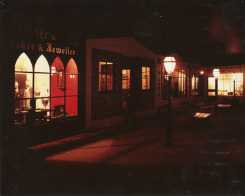
Photograph, 1990s--estimated
Taken in 1990, this photograph depicts a row of shops in Beechworth, with the shopfront of watchmaker and jewellers, William Turner and C.F. Falck, in the foreground, and newsagent and bookseller James Ingram's shop in the background.This photograph is of social significance to the Beechworth community in depicting the Street of Shops, the creation of curator, Roy Harvey, which opened in 1979 at Burke Museum. According to the Indigo Shire Council webpage for Burke Museum, this addition 'began a new period of collecting with Roy Harvey calling to the community for donations. The response resulted in an influx of material adding to the town history/ development and local identities collections. The Shops and their contents reflect another period in museology.' The historic shopfronts in this image portray those of local settlers, William Turner and CF Falck's Watchmaker and Jeweller store, and James Ingram's news agency and bookshop. William Turner was originally a goldfields official who became a commissioner on the Ovens goldfield, and later a resident warden, at times performing magisterial duties and chairing the Local Court. Charles Frederick Falck, born in Korlin, Germany, in 1833, a skilled watchmaker and jeweller, ran the jewellery business from 1862. Along with William Turner and Melbourne barrister, George Milner Stephen, he prepared a dazzling display of gems and jewellery from Beechworth for the Royal Society's Exhibition in Melbourne in 1865. This act signposted Beechworth's progress as a nineteenth-century gold rush town with a population of around 3000. In the mid-1850s, newsagent James Ingram established a newsagency and supplied papers and stationary to the goldfields. He and bookseller R.T. Vale stocked a wide range of literary, historical and religious works, textbooks, periodicals and newspapers, as well as hosting a reading and writing room on Camp Street{?}. James Ingram was a 'devoted instigator and supporter of the town's welfare institutions', who raised funds for to establish a hospital, primary school and benevolent asylum, and assisted people who'd fallen on hard times with his wife. He was also a mainstay of the early Baptist church, holding meetings in his house. He died in 1928, six weeks short of his 100th birthday. Ingram's Rock, north-west of Beechworth near where he lived in later life, was named after him. Colour rectangular photograph printed on matte photographic paper.Obverse: FALCK 1880 / maker & Jeweller/ WARDENS OFFICE/COACHING OFFICE/ EST. ??55/ ????ON HOUSE/ JAMES INGRAM/ NEWS?????? AND BOOKSELLER/ TOYS visible above shopfront in left foreground. Reverse: Catalogue item number 3305 pencilled in top right-hand corner.beechworth, beechworth historic shops, william turner, cf falck, james ingram, turner and falck watchmaker and jeweller, james ingram newsagent and bookseller, burke museum, promoting settlement, marketing and retailing, living in country towns, making regional centres, preserving traditions and commemorating, beechworth founders, victorian gold rush towns, beechworth pioneers, ingram's rock, 1860s beechworth, street of shops, roy harvey -
 The Beechworth Burke Museum
Audio - Oral History, Joyce Snow
Joyce Snow was born in Avenel and came to Beechworth at the age of twenty-three. She grew up at Bundarta, a place just out of Shepparton. Her father was a soldier who was part of the 37th Battallion while her mother's family were some of the pioneers of Beechworth--the Duracks. She finished school at about thirteen years old, did a correspondence course, and when she was old enough, she went training for nursing. Joyce was a trained nurse at the old Mooroopna Base, Hospital. She working at a Hospital in Shepparton when Manpower sent her to Beechworth. She arrived at Beechworth in 1943 at a train in Wangaratta. She had been a nurse in Beechworth for more than seven years. She got married in Beechworth and had three children, two girls and one boy. By the time of her third child, she studied a one year supplementary course on Psychy at May Day. Joyce had nursed prisoners of the First World War. She shared about the differences of medical practice back then in comparison to now. This oral history recording was part of a project conducted by Jennifer Williams in the year 2000 to capture the everyday life and struggles in Beechworth during the twentieth century. This project involved recording seventy oral histories on cassette tapes of local Beechworth residents which were then published in a book titled: Listen to what they say: voices of twentieth century Beechworth. These cassette tapes were digitised in July 2021 with funds made available by the Friends of the Burke.Joyce Snow's account of her life in the early 20th century is historically and socially significant to the cultural heritage of the region. She gave information about the settlements and life of the prisoners of First World War, the early forms of entertainment, education system and societal roles. She also mentioned changes in employment and migrant communities. This oral history account is socially and historically significant as these accounts provide a unique insight into the day-to-day life of the town's residents during the 20th century, many of which will have now been lost if they had not been preserved.This is a digital copy of a recording that was originally captured on a cassette tape. The cassette tape is black with a horizontal white strip and is currently stored in a clear flat plastic rectangular container. It holds up 40 minutes of recordings on each side.Joyce Snowburke museum, beechworth, hospital, oral history, nursing, nurse, first world war, prisoners of war, tatatura, moonrapna, peritontitis, doctors, tuck shops, largactil, rock films, victoria park, kings in grass castle, durack, duracks, glory box, d'oylies -
 Camperdown & District Historical Society
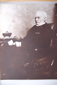
Photograph - James Dawson, Thomas Rodger, c1881
James Dawson (1806-1900), pastoralist, friend to First Nations people, environmentalist, patron of the Arts and author of "Australian Aborigines" (1881). Dawson came from Bonnytoun, near Linlithgow, Scotland and arrived in Melbourne with his wife, Joan Alexander Park, on 2 May 1840. They made their first home in the colony farming in Port Phillip, near Anderson's Creek on the Yarra River, where their daughter, Isabella was born in 1842, then from 1844, moved to 'Kangatong' station on the Moyne River, east of Macarthur. In 1866 the Dawsons left the Port Fairy district and lived in various residences in Melbourne. By 1868 the family had settled in Camperdown at 'Wuurong', on the banks of Lake Bullen Merri. Unlike most people at the time, Dawson and his daughter shared a deep interest in, and respect for First Nations people. In 1876 James Dawson was appointed local Guardian of the Aborigines in the Camperdown district. He was a prolific letter writer and an early advocate for indigenous rights and was dedicated to exposing injustice and the maltreatment of First Nations people. He had befriended Wombeetch Puyuun (Camperdown George) who was the last of the local Djargurd Wurrung living on Country when he died in February 1883. In 1885 James Dawson erected the Wombeetch Puyuun Monument at Camperdown Cemetery in his memory. His friend's remains were reburied at the foot of the obelisk and the two dates, 1840-1883, mark the 43 years it took for European settlement to displace the Djargurd Wurrung from the Camperdown District.Sepia photograph of an elderly James Dawson taken in Scotland. Front: T. Rodger St. ANDREWS N.B. Back: THOMAS RODGER Photographer ST. ANDREWS ETABLISHED 1849cdhs, isabella dawson, camperdown cemetery, djargurdwurrung, cdhsfirstnations -
 Camperdown & District Historical Society
Book - The James Dawson Scrapbook, c1881
James Dawson (1806-1900), pastoralist, friend to First Nations people, environmentalist, patron of the Arts and author of "Australian Aborigines" (1881). Dawson came from Bonnytoun, near Linlithgow, Scotland and arrived in Melbourne with his wife, Joan Alexander Park, on 2 May 1840. They made their first home in the colony farming in Port Phillip, near Anderson's Creek on the Yarra River, where their daughter, Isabella was born in 1842, then from 1844, moved to 'Kangatong' station on the Moyne River, east of Macarthur. In 1866 the Dawsons left the Port Fairy district and lived in various residences in Melbourne. By 1868 the family had settled in Camperdown at 'Wuurong', on the banks of Lake Bullen Merri. Unlike most people at the time, Dawson and his daughter shared a deep interest in, and respect for First Nations people. In 1876 James Dawson was appointed local Guardian of the Aborigines in the Camperdown district. He was a prolific letter writer and an early advocate for indigenous rights and was dedicated to exposing injustice and the maltreatment of First Nations people. He had befriended Wombeetch Puyuun (Camperdown George) who was the last of the local Djargurd Wurrung living on Country when he died in February 1883. In 1885 James Dawson erected the Wombeetch Puyuun Monument at Camperdown Cemetery in his memory. His friend's remains were reburied at the foot of the obelisk and the two dates, 1840-1883, mark the 43 years it took for European settlement to displace the Djargurd Wurrung from the Camperdown District.The James Dawson Scrapbookcdhs, isabella dawson, camperdown cemetery, djargurdwurrung, cdhsfirstnations -
 Camperdown & District Historical Society
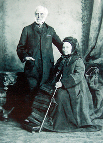
Photograph - James and Joan Dawson, studio photograph, c1878
James Dawson (1806-1900), pastoralist, friend to First Nations people, environmentalist, patron of the Arts and author of "Australian Aborigines" (1881). He married Joan Alexander Park in 1877. Joan was the niece of the famous African explorer, Mungo Park. James Dawson came from Bonnytoun, near Linlithgow, Scotland and arrived in Melbourne with his wife on 2 May 1840. They made their first home in the colony farming in Port Phillip, near Anderson's Creek on the Yarra River, where their daughter, Isabella was born in 1842, then from 1844, moved to 'Kangatong' station on the Moyne River, east of Macarthur. In 1866 the Dawsons left the Port Fairy district and lived in various residences in Melbourne. By 1868 the family had settled in Camperdown at 'Wuurong', on the banks of Lake Bullen Merri. Unlike most people at the time, the Dawson's shared a deep interest in, and respect for First Nations people. In 1876 James Dawson was appointed local Guardian of the Aborigines in the Camperdown district. He was a prolific letter writer and an early advocate for indigenous rights and was dedicated to exposing injustice and the maltreatment of First Nations people. He had befriended Wombeetch Puyuun (Camperdown George) who was the last of the local Djargurd Wurrung living on Country when he died in February 1883. In 1885 James Dawson erected the Wombeetch Puyuun Monument at Camperdown Cemetery in his memory. His friend's remains were reburied at the foot of the obelisk and the two dates, 1840-1883, mark the 43 years it took for European settlement to displace the Djargurd Wurrung from the Camperdown District.Studio portrait of James and Joan Dawson taken in Australia. cdhs, isabella dawson, camperdown cemetery, djargurdwurrung, cdhsfirstnations -
 Camperdown & District Historical Society
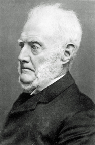
Photograph - James Dawson, c1878
James Dawson (1806-1900), pastoralist, friend to First Nations people, environmentalist, patron of the Arts and author of "Australian Aborigines" (1881). Dawson came from Bonnytoun, near Linlithgow, Scotland and arrived in Melbourne with his wife, Joan Alexander Park, on 2 May 1840. They made their first home in the colony farming in Port Phillip, near Anderson's Creek on the Yarra River, where their daughter, Isabella was born in 1842, then from 1844, moved to 'Kangatong' station on the Moyne River, east of Macarthur. In 1866 the Dawsons left the Port Fairy district and lived in various residences in Melbourne. By 1868 the family had settled in Camperdown at 'Wuurong', on the banks of Lake Bullen Merri. Unlike most people at the time, Dawson and his daughter shared a deep interest in, and respect for First Nations people. In 1876 James Dawson was appointed local Guardian of the Aborigines in the Camperdown district. He was a prolific letter writer and an early advocate for indigenous rights and was dedicated to exposing injustice and the maltreatment of First Nations people. He had befriended Wombeetch Puyuun (Camperdown George) who was the last of the local Djargurd Wurrung living on Country when he died in February 1883. In 1885 James Dawson erected the Wombeetch Puyuun Monument at Camperdown Cemetery in his memory. His friend's remains were reburied at the foot of the obelisk and the two dates, 1840-1883, mark the 43 years it took for European settlement to displace the Djargurd Wurrung from the Camperdown District.Side portrait of an elderly James Dawson. cdhs, isabella dawson, camperdown cemetery, djargurdwurrung, cdhsfirstnations -
 Orbost & District Historical Society
map/poster, Victorian Government Printer, 22.4.1926
... of early settlement history in Murrangower, between Cabbage Tree ...The Department of Crown Lands and Survey was originally established in 1857 as part of the Board of Land and Works. In 1964 it ceased to be controlled by the Board. The Department functioned for almost twenty more years before being combined with other Ministries to form the Department of Conservation, Forests and Land. It was responsible for the management of the State's Crown land and pastoral estates. This map was used by Don Mehlert after 1928. The VERMIN AND NOXIOUS WEEDS ACT 1928 was an Act to consolidate the Law relating relating to Vermin and Noxious Weeds. E. J. E. G. Pemberton who published this poster was Superintendent of Field Staff, Dept. of Lands and Survey. This map and posters are significant records of early settlement history in Murrangower, between Cabbage Tree and Orbost,A paper map of Murrangower showing settlement subdivisions. This is glued onto the back of four overlapping cloth poster of "Notices of Vermin Destruction". All print is black."DON MEHLERT" in black pen. Pike's block shaded in blue. School site marked in blue pencil. on poster "MURRANGOWAR" along side.map-murrangower poster-vermin-and-noxious-weeds murrangower-settlement -
 Orbost & District Historical Society
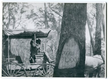
black and white photograph, 1913
... remaining physical legacies of early European land settlement ...When marking a boundary for a registered plan, a surveyor would place “Reference Marks” with a stated bearing and distance to a boundary corner. These trees were typically marked by cutting the bark of the tree in a shield or blaze. Until July 1886, surveyors were only able to use trees as reference marks to boundary corners. After July 1886 surveyors were able to use “permanent marks” which were either a glass bottle, gas pipe or iron bolt (for homestead surveys only). This photograph shows the reference tree, 83 miles from Marlo via the original surveyed road v ia Sydenham Inlet and Tamboon, south of Mount Drummer to the New South Wales border - now the Princes Highway.This is a pictorial record of an old survet tree. Knowledge of their location, abundance and condition not only provide important insights to past survey practice, but also provide a lasting legacy of a regions land-use history. Old survey trees serve as one of the few remaining physical legacies of early European land settlement history.A large black / white photograph of a horse and buggy pulled up alongside a reference tree which has notches and markings of Roman numerals.on back - " Refernce tree 83 miles from Marlo........to N.S.W. Border"survey-tree reference-tree -
 Orbost & District Historical Society
black and white photograph, 1901
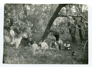
This photograph was taken at the "old station" at Corringle near Orbost. It was a popular picnic spot. Late in 1857 Mr Thomas T. Stirling took over Corringle Run ("Corringle" means "shallow water"). Mr Stirling and his family came from the wester district - Winchelsea. He settled at the Old Station. A few people were employed at the Orbost Stationb and there was settlement on the Orbost flats, Mr T. T. Stirling held the land from Lake Tyrers to Bemm River as a cattle run. About 1888 he became Secretary of the new Tambo Shire.This is a contemporary pictorial record of rural family life in Orbost in the early 20th century.A black / white photograph of a group of people sitting in a clearing under some trees having a picnic. On the left - hand side is a young boy on a horse.on back - "Old Station"old-station-orbost family-life -
 Orbost & District Historical Society
black and white photograph, 1901
The Old Station at Corringle was a popular picnic spot in 1901. Late in 1857 Mr Thomas T. Stirling took over Corringle Run ("Corringle" means "shallow water"). Mr Stirling and his family came from the wester district - Winchelsea. He settled at the Old Station. A few people were employed at the Orbost Stationb and there was settlement on the Orbost flats, Mr T. T. Stirling held the land from Lake Tyrers to Bemm River as a cattle run. About 1888 he became Secretary of the new Tambo Shire.This is a contemporary pictorial record of rural family life in Orbost in the early 20th century.A black / white photograph of a group of early settlers (it appears to be a family group) having a picnic underneath trees. There is a young boy on a horse on the left hand side.on back - "Picnic at the Old Station"family-rural-life-orbost old-station-corringle -
 Orbost & District Historical Society
black and white photograph, first half 20th century
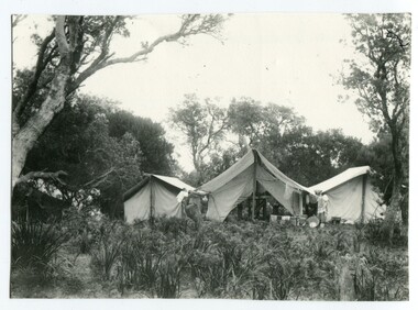
This photograph is linked with photograph 1168. Orbost locals have been taking camping holidays at East Cape since at least the early 20th century. From the mid-1940s about a dozen huts were located there, mostly by locals from the Orbost area, to establish what was known as the 'Conran Settlement' or 'Conran Community'. These huts were subject to permissive occupancy laws which were invoked by the State Labor Government to force their removal in 1986. (Wikipedia)Orbost locals have been camping at Cape Conran since at least the early 20th century. This campsite is from a time before Cape Conran Coastal Park a 11,700 hectare area was declared a coastal park under the National Parks Act in 1997 and camping areas were formalised.A black / white photograph showing three large tents side by side in a bush setting. The middle tent is open and set up as a kitchen and the outer two appear to be sleeping quarters. There is fishing equipment against the middle tent - nets and tin tubs.on back - " Camping at C. Conran"cape-conran recreation-camping -
 Orbost & District Historical Society
black and white photograph, 1916
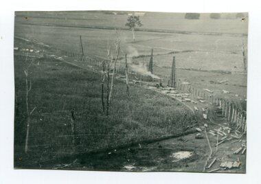
This photograph shows the pile drivers at work in the construction of the viaduct across the Snowy River flats. The Snowy River Floodplain Railway Bridges, two sequential and exceptionally long and low timber railway bridges on the Snowy River floodplain just west of Orbost, were built in 1916, and provided the original terminus point for the Bairnsdale-Orbost railway. The bridges are 770 metres and 183 metres long respectively. The shorter bridge is of uniformly 4.57 metre timber-beam construction, and has a sweeping curve in its deck. The longer bridge has a combination of 4.57 metre and 6.1 metrespans, and two 3.66 metre spans. The bridges are constructed from 'Southern Mahogany', Eucalyptus Botryoides, which grew along the coast east of Bairnsdale. The Snowy floodplain bridges were initially built in the context of an early twentieth-century interest in American-style 'Developmental Railways', designed to open remote areas to closer settlement, even if that meant running at a loss. The line was closed in August 1987. (information from Victorian Heritage Database)This item is associated with the history of the Orbost-Bairnsdale railway line and therefore reflects the role that the rail line played in the social and economic history of Orbost.A black / white photograph of the farming flats at Orbost during the construction of the East Gippsland railway.orbost-railway east-gippsland-railway viaduct-orbost transport railway -
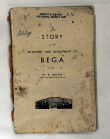 Orbost & District Historical Society
book, The Story of the Settlement and Development of Bega, 1942
After being out of print for 30 years this book has been reprinted in 1987 as a tribute to W.A. Bayley (dec.). WA Bayley had been a public school teacher and was principal of Bega Intermediate High when he researched and wrote his history in the 1940s. He wrote history books on all the towns where he worked,A 120 pp book titled "The Story of the Settlement and Development of Bega". The author is William Alan Bailey (1910-1981). it was published by Bega Intermediate High School.The book contains biographical sketches of some of the early settlers. It also includes maps, newspaper clippings of historical articles, official and handwritten correspondence. The cover title is History of Bega. bega bayley-w.a. bega-settlement -
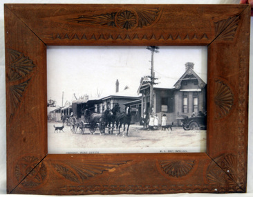 Orbost & District Historical Society
framed photograph, Vogt. W.S, 1917
This photograph was on display in the Orbost Information Centre - the Slab Hut - for many years. Originally the post office was not at Orbost at all but in the small settlement of Newmerella. The building in the photograph was completed and opened in 1898 at a cost of 1038/4/8 pounds. The post office building today is a replica of this building, opened in 2004 after a local campaign to retain a full post office in the town.The photograph of the early post office shows that it was a popular meeting place. Today's post office is a replica of this one and stands on the same site.A framed photograph of the Orbost Post Office (photocopy?) in 1917. The glass was cracked and has been removed. The frame is a wooden one with carved shell shape decorations. In the foreground of the photo is a horse and coach and an early model car. The mail coach is on its way to Cann River. In the car is the Warren family.W.S. Vogt, Bairnsdaleorbost post-office -
 The Beechworth Burke Museum
Photograph, Unknown
The A1 Gold Mine is located north of Woods Point, near Jamieson, in the Upper Goulburn region of Victoria. Gold was discovered at the A1 site in 1861 and mining operations began in 1864. The A1 Mine Settlement refers to a small township known variously as Castle Reef, Castle Point, and Raspberry Creek, which developed in the 1860s around mining industry centred on a crushing machine that worked the three gold reefs in the area. Historically, the name "A1"referred to the high quality of gold found in the quartz reefs at depths of at least two thousand feet. Along with the Morning Star mine at Woods Point, the A1 gold mine produced almost sixty percent of Victoria's gold output in the 1950s to 1970s and continued operating until 1992 when it went into administration. Operations at the site were revived in 2016 and the A1 Mine is now considered one of Victoria's premier gold mines. The A1 mine is part of the extensive and prospective Lachlan Fold Belt, a north-west trending belt of tightly folded Early Devonian sedimentary rocks extending from New South Wales to Victoria. Mineralisation is hosted within or immediately adjacent to diorite dykes. Contemporary development of the 'Queens Lode' at the A1 mine signals a move from high-grade, narrow vein airleg mining into larger scale, mechanical mining designed to increase ore production volume. This original, undated photograph of the A1 Mine appears to depict an area or phase of disuse or abandonment. The aged and humble appearance of the cottage suggests association with the historical A1 Mine Settlement, therefore the image may have been taken prior to the 1950s-1970s revival period in which the A1 mine is known to have produced high gold yields. The photograph contributes to our understanding of the A1 Gold Mine's impact on the landscape and the social, environmental impacts of mining on communities and may be compared with others in the Burke Museum's extensive collection of mining photographs to deepen our understanding of mining in the Jamieson area.Black and white rectangular photograph printed on photographic paperReverse: 5577 / A1 Mine / Near Jamieson / Vic. /burke museum, beechworth museum, beechworth, gold fields, gold rush, victorian gold rush, mining tunnels, gold ming history, colonial australia, australian gold rushes, mining technology, beechworth historic district, indigo gold trail, indigo shire, upper goulburn shire, jamieson, woods point-walhalla goldfield, a1 gold mine, victorian high country, modern mining methods, orogenic gold province, gold mineralisation, devonian, dykes -
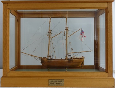 Flagstaff Hill Maritime Museum and Village
Craft - Ship Model, Port Jackson Schooner
This ship model is of a Colonial Port Jackson schooner, originally designed by the British Admiralty in 1803 as a response to the request of New South Wales' Governor Arthur Phillip. The drafts for the original plans are in Greenwich, UK, in the National Maritime Museum. The model is a Ledition edition, number 2 of 5, modelled by Bill Leonard. The model is rigged and decked in the manner of David McGregor. The flag on model of Port Jackson schooner is that of the British White Ensign which was used as the flag design of the Royal Australian Navy from 1911 - 1967. In 1785 the First Fleet arrived in the new British colony of Port Jackson (now Sydney Harbour) in New South Wales and Arthur Phillip was appointed as the first Governor. The following year Governor Phillip asked the English Royal Navy to provide drafts and materials for two ships for use in the Port Jackson colony for exploring and surveying rivers. The vessels needed a shallow draught and to be made from local cedar timber. He asked for the frames of the schooners to be provided along with shipwrights to assemble them. Many years later, in 1803, Governor Phillip’s request was fulfilled but he had already resigned from his post. The drafts titled ‘Schooner for Port Jackson’ were despatched by the Royal Navy from England to Australia. The original draft is still in the National Maritime Museum in Greenwich, UK. Meanwhile, the NSW Government had already built various other ships before 1803. In 1797 His Majesty’s Dockyard was opened at Port Jackson for building larger vessels. The Royal Navy’s 1803 design of a ‘Schooner for Port Jackson’ has been recognised on the obverse of Australia’s twenty dollar banknote since 1994. A sketch of the schooner is beside the portrait of Mrs Mary Reibey, who arrived as a convict and rose to become a respected and successful owner of a cargo shipping business. Her fleet included the Mercury, a schooner similar to the 1803 design for the Port Jackson schooner. Although the 1803 plans for a ‘Schooner for Port Jackson’ are commonly believed to be used for the first ship built in Australia, no records have been found of any ships being built according to these plans. However, it can be claimed that the plans were the ‘first Royal Navy plans made for a ship for use at Port Jackson, and to be built at Port Jackson, in Australia’. William (Bill) Leonard passed away on March 1st 1995.This ship model is significant for its representation of an early Australian colonial schooner. The 1803 Royal Navy’s plans for the colonial ‘Schooner for Port Jackson, were for the first ship specifically designed by the Royal Navy to be built and used in Port Jackson, for use in exploration and surveying of Australian ports and rivers. The plans are associated with Australia’s colonial settlement in the late 1700s. This ship model is significant for its association with the emblems of Australia’s history on the twenty dollar banknote. The colonial Port Jackson schooner is considered significant to Australian history, and represented on the 1994 twenty dollar banknote and its new version being rolled out in October 2019.Ship model of a colonial Port Jackson Schooner. Two-masted sailing ship displaying the flag named The British White Ensign. Mode of light coloured stained timberl is mounted on brass legs inside a glass case with timber frame and base. Metal engraved plaque states that the model is as designed by The Admiralty in 1803. Model is a number 2 of 5 in a limited edition, made by Bill Leonard.Engraved on metal plaque "PORT JACKSON SCHOONER / As Designed By The Admiralty. 1803"flagstaff hill, warrnambool, shipwrecked-coast, flagstaff-hill, flagstaff-hill-maritime-museum, maritime-museum, shipwreck-coast, flagstaff-hill-maritime-village, ship model port jackson schooner, sailing ship, limited edition model, model maker bill leonard, david mcgregor design, maritime trade, maritime vessel, colonial port jackson schooner, pacific island trade in early 1800s, sydney cove, governor arthur phillip, governor philip gidley king, a schooner for port jackson, national maritime museum greenwich, australian $20 banknote -
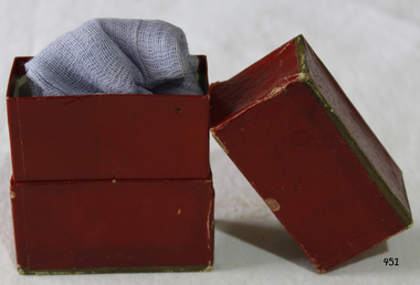 Flagstaff Hill Maritime Museum and Village
Equipment - Gauze & Box, Early - Mid 20th Century
... help in early settlement days of Victoria could take quite some ...When used as a medical dressing, woven gauze is usually made of cotton. It is especially useful for dressing wounds where other fabrics might stick to the burn or laceration. Many modern medical gauzes are covered with a perforated plastic film such as Telfa or a polyblend which prevents direct contact and further minimizes wound adhesion. Also, it can be impregnated with a thick, creamy mixture of zinc oxide and calamine to promote healing, as in Unna's boot. (An Unna’s boot is a special gauze (usually 4 inches wide and 10 yards long) bandage, which can be used for the treatment of venous stasis ulcers and other venous insufficiencies of the leg. It can also be used as a supportive bandage for sprains and strains of the foot, ankle and lower leg. The gauze is impregnated with a thick, creamy mixture of zinc oxide and calamine to promote healing. It may also contain acacia, glycerin, castor oil and white petrolatum.) Gauze is also used during procedures involving accidental tooth loss; either the gauze is used to provide pressure as the tooth is moved back into its corresponding socket, or the tooth is wrapped in gauze and placed in milk or saline to keep it alive while the tooth is being transported or prepared for reinsertion. https://en.wikipedia.org/wiki/GauzeAccess to emergency medical help in early settlement days of Victoria could take quite some time, especially in remote areas. From 1888 First Aid Kits and instructions became available for work sites, offices, community groups and individuals, helping to bridge the gap between the accident and the arrival of medical assistance. Gauze was widely used in many medical conditions.Gauze and maroon box with sliding top, purple bandage (gauze) inside. Gold rim top and bottom. None.flagstaff hill, warrnambool, shipwrecked-coast, flagstaff-hill, flagstaff-hill-maritime-museum, maritime-museum, shipwreck-coast, flagstaff-hill-maritime-village, first aid bandages, dressings, medical -
 Flagstaff Hill Maritime Museum and Village
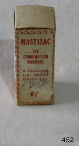
Equipment - Gauze & Box, Flexlock Products, Early - Mid 20th Century
... ://en.wikipedia.org/wiki/Gauze Access to emergency medical help in early ...When used as a medical dressing, woven gauze is usually made of cotton. It is especially useful for dressing wounds where other fabrics might stick to the burn or laceration. Many modern medical gauzes are covered with a perforated plastic film such as Telfa or a polyblend which prevents direct contact and further minimizes wound adhesion. Also, it can be impregnated with a thick, creamy mixture of zinc oxide and calamine to promote healing, as in Unna's boot. (An Unna’s boot is a special gauze (usually 4 inches wide and 10 yards long) bandage, which can be used for the treatment of venous stasis ulcers and other venous insufficiencies of the leg. It can also be used as a supportive bandage for sprains and strains of the foot, ankle and lower leg. The gauze is impregnated with a thick, creamy mixture of zinc oxide and calamine to promote healing. It may also contain acacia, glycerin, castor oil and white petrolatum.) Gauze is also used during procedures involving accidental tooth loss; either the gauze is used to provide pressure as the tooth is moved back into its corresponding socket, or the tooth is wrapped in gauze and placed in milk or saline to keep it alive while the tooth is being transported or prepared for reinsertion. https://en.wikipedia.org/wiki/GauzeAccess to emergency medical help in early settlement days of Victoria could take quite some time, especially in remote areas. From 1888 First Aid Kits and instructions became available for work sites, offices, community groups and individuals, helping to bridge the gap between the accident and the arrival of medical assistance. Gauze was widely used in many medical conditions.Gauze and box entitled "MASTISAC?. The Combination Bandage" Bandage is complete with instructions for use inside.Mastisac ‘The combination Bandage. A convenient and effective FIRST AID. Prepared and distributed by Flexlock products, 15 Mills Street, Albert Parkflagstaff hill, warrnambool, shipwrecked-coast, flagstaff-hill, flagstaff-hill-maritime-museum, maritime-museum, shipwreck-coast, flagstaff-hill-maritime-village, first aid, bandages, dressings, medical -
 Orbost & District Historical Society
black and white photograph, late 19th century - early 20th century
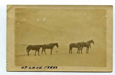
In the late 19th century in the Orbost area roads were just bush tracks which generally were unsuitable for any type of vehicular traffic so were traversed mainly by horseback. As the settlement grew, a weekly mail service from Cunninghame (Lakes Entrance) was estab-lished. The settlers had to carry the mail for three months and each took a turn as mailman during that time. The first coach was driven by Mr Alex Hall. Eventually a daily mail service was set up and many drivers included B. Sutherland, W. Middleton, Jonson Bros., J. Mitchell, F. Newport, J. Geddes, A. Coulson, Bert Cessor, H. Weekes and A. Barthile. (info. from Newletter August 2007) This photograph is one of A. Coulson’s Coach crossing the Sand Bar at Lake Tyers.This is associated with early transport in East Gippsland.A black / white postcard photograph of four horses alone on a beach.on front - At Lake Tyers on back - "Mr A. Coulson, coach driver, Orbost"lake-tyers coulson-coach-driver transport-horse-drawn -
 Orbost & District Historical Society
black and white photograph, Warren, Mrs H, first half 20th century
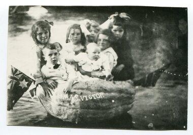
These children are the Rice family. In 1925 Walter Rice built a general store in Marlo and in 1930 built the "Ozone Picture Theatre" also in Marlo.This item is associated with a popular activity of the Orbost community in the first half of the 20th century. Pumpkins have been been part of the district's agricultural history since settlement. It is associated with Walter Rice a prominent citizen of Marlo in the early 20th century.A black / white photograph of a group of six children sitting in a pumpkin in water. there is a flag on each side and "HMAS VICTOR" on the side of the pumpkin.pumkins-orbost warren-helena rice-walter -
 Warrnambool and District Historical Society Inc.
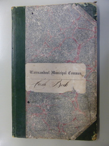
Ledger, Warrnambool Municipal Common, Circa 1865
This cash book contains entries which relate to the everyday operation of the Borough Common which predates the establishment of Warrnambool as a town. All ratepayers had the right to graze their cows on the common, with the cows being collected every morning by the herdsman and walked to the common. Entries relate to items such as eradication of thistles, repairs and erection of stock yards, burying of dead stock, purchase of bulls and clearing of waterholes. Salaries were paid to E. Margetts, D Allan, T Raingill, and M T Read. Auditors were James Dickson. After WW1 parts of the common were allocated to soldiers’ settlement blocks ranging from 18 to 30 acres. Other parts remained with the Crown for Municipal uses and part became the Warrnambool Golf Course. In 1925 the common was abolished.The entries in this book record the operations and earliest residents who were involved in the Common in the early days of WarrnamboolGrey and red mottled card cover with dark green points and spine. Paper label on front cover. Dark blue and tan mottled paper inside front and back covers. Warrnambool Municipal Common Cash Book.warrnambool borough, warrnambool common, e margetts, raingill, d allan, m t read, warrnambool common cash book -
 Warrnambool and District Historical Society Inc.
Book - Facsimile: John Mackersey 1826-1892, Stock Book 1857-1870, 2014
... in the Western District of Victoria and it dates from a period of early ...This ledger relates to the property Kenilworth which is situated near Cavendish, 16 miles from Hamilton on the Wannon River. It was taken up by Thomas Norris in 1839 and originally carried 800 cattle and 20000 sheep on 63000 acres. By 1858 it was in the hands of John Mackersey and Thomas Bostock. In 1859 it belonged outright to John Mackersey who was there until 1870. He was considered a worthy son of a Presbyterian minister and was well regarded in the district for his contributions in church, sport and sheep breeding... However he did not do well and lost the property before going to New Zealand in 1870. These journals provide a yearly record of flock, harvest and yields along with income details. It also provides details relating to rentals, selections and purchases during the era from squatting to freehold land. This journal provides a detailed view of matters relating to the business of sheep farming. It records purchases and stock sold, wool clips, lambs, sheep losses and different breeds. Kenilworth was a significant property in the Western District of Victoria and it dates from a period of early settlement in Victoria.Dark green hard cover with gold lettering. Both covers have in gold lettering: John Mackersey1826-1892 Stock Book 1857-1870. One cover has Horses and cattle and the other, sheep. It is a facsimile copy. The two sections are divided by a green sheet of paper. Acknowledgements to The State Government of Victoria, State Library of Victoria, Hamilton History Centre, Dr G Handbury AO, Margaret Gardiner, Godfrey and Margaret Mackersey, L Alan Brumley, M P Heuval. john mackersey, thomas bostock, thomas norris, kenilworth, history of warrnambool -
 Warrnambool and District Historical Society Inc.
Book - Diary Facsimile: John Mackersey, Journal 1867-75, 2014
... . This journal provides an insight into early settlement in the Western ...John Mackersey farmed the property Kenilworth which is situated near Cavendish, 16 miles from Hamilton on the Wannon River. It was taken up by Thomas Norris in 1839 and originally carried 800 cattle and 20000 sheep on 63000 acres. By 1858 it was in the hands of John Mackersey and Thomas Bostock. In 1859 it belonged outright to John Mackersey who was there until 1870. He was considered a worthy son of a Presbyterian minister and was well regarded in the district for his contributions in church, sport and sheep breeding... However he did not do well and lost the property before going to New Zealand in 1870. This diary contains entries for the latter part of that period as well as entries from his time in New Zealand.This journal provides an insight into early settlement in the Western District of Victoria.Dark green hard cover with gold lettering on front cover. 210 Pages. Title page has photograph of diarist and period of entries. 10 Mar 1867- 6 Apr 1875. The pages are a copy of handwritten entries in his original diary.Acknowledgements to The State Government of Victoria, State Library of Victoria, Hamilton History Centre, Dr G Handbury AO, Margaret Gardiner, Godfrey and Margaret Mackersey, L Alan Brumley, M P Heuval. john mackersey, thomas norris, thomas bostock, kenilworth, warrnambool history -
 Warrnambool and District Historical Society Inc.
Book, Woolsthorpe Primary School and Woolsthorpe Soldier Settlement
History of the Woolsthorpe Primary School and Woolsthorpe Soldier SettlementThis is a soft-cover book with a blue and buff- coloured front cover featuring photographs of the Woolsthorpe Primary School and the Woolsthorpe War Memorial. The back cover has photographs of the R.S.L. Badge and the Woolsthorpe Primary School. It has 160 pages. non-fictionHistory of the Woolsthorpe Primary School and Woolsthorpe Soldier Settlementwarrnambool, woolsthorpe, soldier settlement -
 Warrnambool and District Historical Society Inc.
Booklet - Booklet about Port Fairy, Life before Folkie, 2013
This booklet aims to give a brief outline of Port Fairy’s history for the benefit of visitors. Port Fairy was an early sealing and whaling town with white settlement established by 1836. As the port and shipping declined so did the town until its reinvigoration in the mid 20th century as a tourist town and the home of the annual Port Fairy Folk FestivalThe book is of use as a quick reference to Port Fairy history.This is a booklet of 48 pages. It contains printed material, black and white photographs and a map. The front cover has a black and white image of the Port Fairy lighthouse. Front Cover: ‘Life Before Folkie, A Visitors’ History of Port Fairy, David R. Jones’port fairy, david r. jones -
 Warrnambool and District Historical Society Inc.
Book, Arithmetic, 1842
This is an early school arithmetic book with the front preface indicating it is the third edition published in 1842. The book appears to have been used about the 1860s by members of the Bell family who probably lived at Cudgee. The names of the children, presumably the Bell children, are scattered throughout the book – Margaret, Walter, Sarah and William. No information is available on this Bell family though there are records of births in Warrnambool of Bell children in the 1850s to William and Jane Bell. Cudgee, a small settlement on the Cudgee Creek, is about 16 kilometres from Warrnambool. This book is of some minor interest because of its age and because it has some association with the Bell family who may have lived at Cudgee in the mid 19th century. The exercises in the book are of interest as examples of the arithmetical problems given to children in the mid 19th century. This is a hard cover book of 282 pages. The cover is dark brown with gold lettering on the spine but the front cover and part of the first few pages are missing. The pages are ragged and dog-eared and quite dirty in places. There is handwritten material in both pencil and ink on the front pages, throughout the text and on the back page. ‘Margaret’ ‘Walter’ ‘Sarah’ ‘William Bell’ ‘Cudgee’ mathematics, bell family, cudgee, warrnambool history