Showing 486 items
matching kilometres
-
![Photograph - Digital image, Willis Vale [side view], 1950c](/media/collectors/4f729f5697f83e03086015b8/items/5502a2592162f11024c32328/item-media/5502a2852162f11024c3268d/item-fit-380x285.jpg) Greensborough Historical Society
Greensborough Historical SocietyPhotograph - Digital image, Willis Vale [side view], 1950c
Willis Vale: House built by Edward Maygar, Robert Whatmough lived there mid 19th century and later sold to Partington family. It was located on the Plenty River at Partington's Flat Greensborough. Land use included farming and orchards. The derelict Willis Vale house was vandalized in 1964 and destroyed when a fire originating from North Plenty Gorge - Kurrak Road - was lit by two teenage boys and made its way several kilometres down to Partington's Flat Greensborough. This photo was taken after the Partington's moved house in 1947. across the river where Alan built their new Alwyn house that had access to electricity. Home of the Partington family Home of the Partington familyDigital copy of black and white photograph.willis vale, partington, whatmough, maygar -
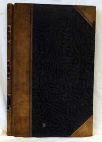
 Orbost & District Historical Society
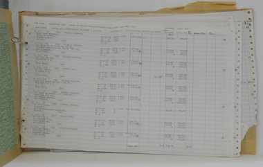
ledger, LOAN ACCOUNT CASH BOOK SHIRE OF ORBOST, 1935-1971
This ledger was used by the Shire of Orbost from 1935-1971. The item was donated to Orbost & District Historical society from P.R.O.V. as a Place of Deposit (POD) item for safe keeping by a local history group or museum. The shire covered an area of 9,347 square kilometres and existed from 1892 until 1994 when it became part of the East Gippsland Shire Council. Orbost was at first included in the Bairnsdale Shire from 1882 and was later part of the Tambo Shire. Because of travelling distances the Croajingalong Shire was created in 1892 (name changed to Orbost Shire 17.2.1893 with James Cameron as the first Shire President. In 1994 it amalgamated to become part of East Gippsland Shire Council. This item comprises records that belonged to the local government accounting system. The Shire of Orbost Council no longer exists having been absorbed by the East Gippsland Shire Council. This is a hand-written record created before the widespread use of computer accounting records.A black, hard cover ledger with light brown leather binding. it is titled "CASh BOOK LOAN ACCOUNT, SHIRE OF ORBOST". Records are hand-written. Inside the back cover is a loose-leaf typed document titled, "Shire Engineers Report 11 Sept 1970".cash-book ledger shire-of-orbost accounting -
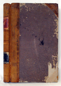
 Orbost & District Historical Society
ledger, TREASURER'S CASH BOOK, 1898 - 1912
This ledger was used by the Shire of Orbost from 1898 to 1912. The item was donated to Orbost & District Historical society from P.R.O.V. as a Place of Deposit (POD) item for safe keeping by a local history group or museum. The shire covered an area of 9,347 square kilometres and existed from 1892 until 1994 when it became part of the East Gippsland Shire Council. Orbost was at first included in the Bairnsdale Shire from 1882 and was later part of the Tambo Shire. Because of travelling distances the Croajingalong Shire was created in 1892 (name changed to Orbost Shire 17.2.1893 with James Cameron as the first Shire President. In 1994 it amalgamated to become part of East Gippsland Shire Council. This item contains handwritten accounting records of the Shire of Orbost. The Orbost Shire local government no longer exists as it was absorbed by the East Gippsland Shire Council.A black, hard cover ledger with light brown leather binding. It is titled "TREASURER'S CASH BOOK" and contains hand-written records.orbost-shire-council ledger-accounts -
 Orbost & District Historical Society
ledger, 1950's
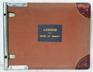
This ledger was used by the Shire of Orbost in 1959. The item was donated to Orbost & District Historical society from P.R.O.V. as a Place of Deposit (POD) item for safe keeping by a local history group or museum. The shire covered an area of 9,347 square kilometres and existed from 1892 until 1994 when it became part of the East Gippsland Shire Council. Orbost was at first included in the Bairnsdale Shire from 1882 and was later part of the Tambo Shire. Because of travelling distances the Croajingalong Shire was created in 1892 (name changed to Orbost Shire 17.2.1893 with James Cameron as the first Shire President. In 1994 it amalgamated to become part of East Gippsland Shire Council. This is a handwritten record of revenue accounts from local government. The Shire of Orbost as a local government no longer exists havinb absobed into the East Gippsland Shire Council.A heavy ledger with a brown cover and steel bindings. The covers are probably wooden. It is alphabetically indexed and the ledger is lockable. it contains revenue accounts for 1959. On the front cover is "LEDGER (underlined) SHIRE OF ORBOST" in gold print. It is an "Emu Binder".accounts-shire-of-orbost local-government -
 Orbost & District Historical Society
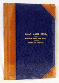
ledger, first half 20th century
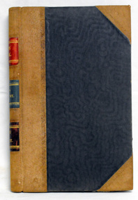
This ledger was used by the Shire of Orbost from 1927 -1940. The item was donated to Orbost & District Historical society from P.R.O.V. as a Place of Deposit (POD) item for safe keeping by a local history group or museum. The shire covered an area of 9,347 square kilometres and existed from 1892 until 1994 when it became part of the East Gippsland Shire Council. Orbost was at first included in the Bairnsdale Shire from 1882 and was later part of the Tambo Shire. Because of travelling distances the Croajingalong Shire was created in 1892 (name changed to Orbost Shire 17.2.1893 with James Cameron as the first Shire President. In 1994 it amalgamated to become part of East Gippsland Shire Council. This item is a handwritten record of the accounts of the Orbost Shire local government. It pre-dates computer records. The Orbost Shire Council no longer exists having been absorbed by the East Gippsland Shire Council.A ledger with a black cover and brown leather binding. It has marbled end pages. On the front cover in gold print is " LOAN LEDGER (underlined) NEWMERELLA DRAINAGE AREA ACCOUNT (underlined) SHIRE OF ORBOST.on spine - "Newmerella Drainage Area Loan Ledger"ledger orbost-shire newmerella-drainage-area accounts -
 Orbost & District Historical Society
ledger, first quarter 20th century
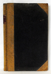
This ledger was used by the Shire of Orbost from 1910 -1925. The item was donated to Orbost & District Historical society from P.R.O.V. as a Place of Deposit (POD) item for safe keeping by a local history group or museum. The shire covered an area of 9,347 square kilometres and existed from 1892 until 1994 when it became part of the East Gippsland Shire Council. Orbost was at first included in the Bairnsdale Shire from 1882 and was later part of the Tambo Shire. Because of travelling distances the Croajingalong Shire was created in 1892 (name changed to Orbost Shire 17.2.1893 with James Cameron as the first Shire President. In 1994 it amalgamated to become part of East Gippsland Shire Council. This item is a hand-written record of the accounts of the Orbost Shire local government. It pre-dates computer records. The Orbost Shire council no longer exists having been absorbed by the East Gippsland Shire council.A ledger with ablack cover with brown leather binding.Pages have marbled edges. It contains hand-written records of transactions relating to the Bete Bolong South Drainage Area.on spine - gold lettering on red " Cash Book" and "Bete Bolong South Drainage Area" ; gold lettering on black " Shire of Orbost"ledger orbost-shire accounts bete-bolong-south-drainage-area -
 Orbost & District Historical Society
credit ledger, 1892-1909
This ledger was used by the Shire of Orbost from 1892 - 1909. The item was donated to Orbost & District Historical society from P.R.O.V. as a Place of Deposit (POD) item for safe keeping by a local history group or museum. The shire covered an area of 9,347 square kilometres and existed from 1892 until 1994 when it became part of the East Gippsland Shire Council. Orbost was at first included in the Bairnsdale Shire from 1882 and was later part of the Tambo Shire. Because of travelling distances the Croajingalong Shire was created in 1892 (name changed to Orbost Shire 17.2.1893 with James Cameron as the first Shire President. In 1994 it amalgamated to become part of East Gippsland Shire Council. This is a hand-written record of the accounts of the local government. The Orbost Shire Council no longer exists having been absorbed into the East Gippsland Shire Council.A heavy ledger with a dark brown cover and lighter brown binding. it has marbled end covers and marbled page edges. It contains accounts records hand-written in ink.on spine in gold lettering - on a red square : "Ledger" - on a black square : "Shire of Orbost"accounts ledger orbost-shire-council -
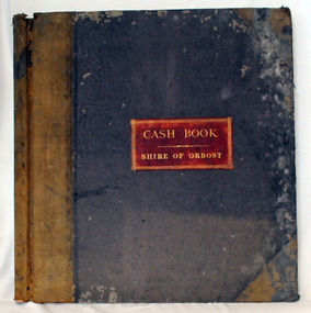 Orbost & District Historical Society
cash book, 1893-1899
This ledger was used by the Shire of Orbost from 1893-1899 . The item was donated to Orbost & District Historical society from P.R.O.V. as a Place of Deposit (POD) item for safe keeping by a local history group or museum. The shire covered an area of 9,347 square kilometres and existed from 1892 until 1994 when it became part of the East Gippsland Shire Council. Orbost was at first included in the Bairnsdale Shire from 1882 and was later part of the Tambo Shire. Because of travelling distances the Croajingalong Shire was created in 1892 (name changed to Orbost Shire 17.2.1893 with James Cameron as the first Shire President. In 1994 it amalgamated to become part of East Gippsland Shire Council This is a handwritten record of the financial transactions of the first Obost Shire Council. This council no longer exists having been absorbed by the East Gippsland Shire Council.A specially printed cash book with a brown cover and lighter brown binding. It has marbled end covers. It contains hand-written accounts of local government transactions .on front inside a red rectangle -"Cash Book Shire of Orbost"cash-book shire-of-orbost accounts -
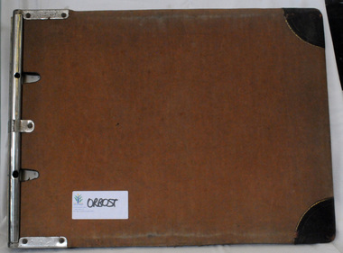 Orbost & District Historical Society
cash book, 1960
This ledger was used by the Shire of Orbost from 1960-1962. The item was donated to Orbost & District Historical society from P.R.O.V. as a Place of Deposit (POD) item for safe keeping by a local history group or museum. The shire covered an area of 9,347 square kilometres and existed from 1892 until 1994 when it became part of the East Gippsland Shire Council. Orbost was at first included in the Bairnsdale Shire from 1882 and was later part of the Tambo Shire. Because of travelling distances the Croajingalong Shire was created in 1892 (name changed to Orbost Shire 17.2.1893 with James Cameron as the first Shire President. In 1994 it amalgamated to become part of East Gippsland Shire Council This is a handwritten record of accounts for the Shire of Orbost Council. It vpredates computer records. The Shire of Orbost no longer exists having been absorbed by the East Gippsland Shire Council.A heavy cash book with wooden covers and metal hinges. It is lockable and contains handwritten records of accounts. Emu Binding.On front cover - East Gippsland Shire council logo label with "ORBOST" handwritten in black. -
 Orbost & District Historical Society
rate books, 1977 - 1984
These items were donated to Orbost & District Historical society from P.R.O.V. as a Place of Deposit (POD) item for safe keeping by a local history group or museum. The shire covered an area of 9,347 square kilometres and existed from 1892 until 1994 when it became part of the East Gippsland Shire Council. The East Gippsland Region Water Authority was constituted on January 1, 1995. The new Authority assumed responsibility for the services previously provided by the Mitchell Water Board, the Tambo Water Board, the Orbost Water Board and the Mallacoota Water Board. East Gippsland Water is the registered business name of the East Gippsland Region Water Authority. (info. from P.R.O.) These items are a historical record of Orbost Shire transactions with water management authorities which no longer exist.Seven rate books for the Shire of Orbost, Mallacoota and Cann River Water Trust. 2554.1 with records from 1977-1978 has a brown cardboard cover and string binding. 2554.2 has a brown cardboard cover with a hand-written title and green string binding. Records are from 1978 -1979. 2554.3 has a brown cardboard cover with a hand-written title and green string binding. Records are from 1919 - 1980. 2554.4 has a white cardboard cover and taped spine. In black print on the cover is 1980/1981. 2554.5 has a green cover with a metal fastening clip. Records are from 1980 -1981. 2554.6 has a white cover, taped binding and metal clips.Records are from 1982 -1983. 2554.7 has a white cover and metal rings. It is dated 1984.water-rates cann-valley-water-board -
 Victorian Interpretive Projects Inc.
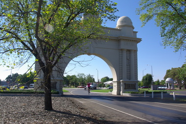
Photograph - Digital, Clare Gervasoni, Samuel Johnson and the 'Love Your Sister' team at the Ballarat Arch of Victory, 16/02/2013
Samuel Johnson is riding around Australia on a unicycle in an attempt to break a world record and raise money for the Garvan Institute (breakthrough medical research) . (www.loveyoursister.org) The Ballarat Courier (18/02/2013) reported: "Actor Samuel Johnson was humbled by the turnout and support in Ballarat for his epic unicycle ride about Australia. After an emotional farewell with sister Connie, who is terminally ill with cancer, Johnson reached Ballarat on day two of his Love Your Sister Ride – an attempt to break the Guinness World Record for the most distance travelled on a unicycle (15,000 kilometres), raise a million dollars for breast cancer research and spread the word for early detection."A unicylist in pink shirt travels under the Ballarat Arch of Victory at the entry to the Ballarat Avenue of Honour. The unicyclist is actor Samuel Johnson.ballarat avenue of honour, ballarat arch of victory, samuel johnson, love your sister, unicycle, cycle -
 Otway Districts Historical Society
Photograph, Crowes: Terminus of the railway line, 1911
The terminus of the railway, and the southern-most station on the Australian mainland, was Crowes, approximately 2 kilometres from Lavers Hill. The line ended at "The Black Stump". Crowes was designed as a fully functioning terminus and received a complete instalment of facilities. The site was laid out with three roads plus a dead end siding for a locomotive shed and ash pit. Goods sheds, a platform and livestock ramps catered for freight loadings, while on the north side was a station office, waiting room, parcels shed and passenger shelter. Three departmental residences were also provided. The resident Station Master was withdrawn in November 1916 and the station closed with the line on 10 December 1954.Photograph. Terminus of the Colac-Crowes at Crowes.crowes; terminus; "the black stump"; -
 Bendigo Historical Society Inc.
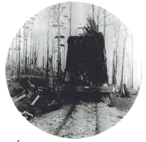
Document - Forests Commission of Victoria Northern Area Fire Protection Policy, Statement, Future Bush Fire Policy, Plan for Fire Control, 1938-1939
Fanned by powerful winds, the Black Friday fires (13 January 1939) swept rapidly across large areas of Victoria, causing widespread destruction. Flames leaped large distances, and giant trees were blown out of the ground by fierce winds. Large pieces of burning bark (embers) were carried for kilometres, starting new fires in places that had not previously been affected by flames. Almost two million hectares burned across the state. Large areas of state forest, containing giant stands of Mountain Ash and other valuable timbers, were destroyed. As a result, approximately 575,000 hectares of reserved forest and 780,000 hectares of Crown land burned.Four Files Forests Commission of Victoria Northern Area Report on the 1938-39 Fire Season; and the Fire Protection Policy in Respect of Field activities Prior to the Incidence of the 1939 Fires. history, bendigo, forests commision of victoria, 1939 bush fires -
 Wodonga & District Historical Society Inc
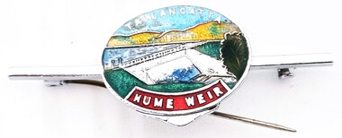
Souvenir - Tallangatta - Hume Weir Tiepin, 1980s
A wide range of items have been created as souvenirs to represent the Hume Weir on the Murray River. Work on Hume Dam started in 1919 and took 17 years to complete. Souvenir items have included chinaware, ashtrays, placemats and small jewellery items such as this tie pin. This tie pin was created as a souvenir for the town of Tallangatta. In the 1950s, the height of the Hume Weir wall was increased, resulting in a nine metre rise in the level of the water in Lake Hume. This necessitated the moving of most of the town of Old Tallangatta due to flooding. The transfer of the township by the State Rivers and Waters Supply Commission to a new site approximately 8 kilometres to the west was completed on 29 June 1956.This item is representative of many items commemorating the Hume Weir and the township of Tallangatta.A small metal and enamelled oval tie pin. It features and image of the Hume Weir.Around top edge in white: TALLANGATTA Around bottom edge" HUME WEIR"hume weir australia, tallangatta, tallangatta - the town that moved -
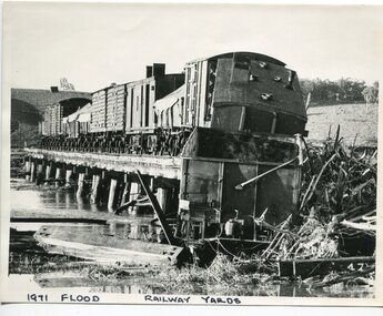 Orbost & District Historical Society
black and white photograph, February 1971
The 1971 flood was the the worst flood on record. At Jarrahmond it was at least 11 metres and up to one and a half kilometres wide on the flats causing enormous damage to the flood plain. Records say that "The brown floodwater stain in Bass Strait could be seen from passing airliners." Considerable damage was done to railway infrastructure, roads and farms. More information from the APRIL, 2008 newsletter by John Phillips. (see orbosthistory.com.au) The railway line was destroyed and was not expected to be opened for a fortnight. Orbost was cut off by 50 square miles of Snowy River floodwater. This train was being shunted across the viaduct when waters smashed through washing away several trucks sending the crew running for their lives.This is pictorial evidence of a significant local event. It is connected to the history of the railway in East Gippsland.A large black / white photograph of flooded railway yards with a train engine stranded on a small section of track surrounded by water and debris.on front - "1971 Flood, Railway Yards"floods-1971-orbost orbost-railway natural-disasters-orbost -
 Warrnambool and District Historical Society Inc.
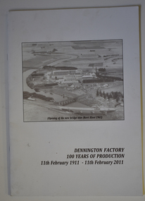
Booklet - Centenary History of Dennington Factory, Dennington Factory 100 Years of Production
Centenary History of the Dennington FactoryThis is a booklet of 24 pages. The front cover has a black and white photograph and black printing and the back cover has a colour photograph, a logo and black printing. The pages contain printed text and black and white and colour photographs. The booklet is stapled.non-fictionCentenary History of the Dennington Factorynestles factory dennington, fonterra factory dennington -
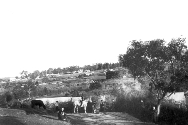 Greensborough Historical Society
Photograph - Digital Image, View of Greensborough from Willis Vale, 1906_
View of Greensborough from Willis Vale. The people in the photograph were visitors and not identified. Willis Vale: House built by Edward Maygar, Robert Whatmough lived there mid 19th century and later sold to Partington family. It was located on the Plenty River at Partington's Flat Greensborough. Land use included farming and orchards. The derelict Willis Vale house was destroyed in 1964 when a fire originating from North Plenty Gorge - Kurrak Road - was lit by two teenage boys and made its way several kilometres down to Partington's Flat Greensborough. [Ellen died on 13/10/1903 - Some think this photo is thought to have been taken shortly after, at her funeral.]Digital copy of black and white photograph.willis vale, greensborough, partington family -
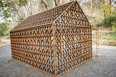 Hepburn Shire Council Art and Heritage Collection
Public Art Work, Jason Waterhouse, 'Cottage' - Jason Waterhouse. 2015, 2014 - 15
The iconic bush surrounds of Lake Daylesford are now home to a new permanent artwork titled Cottage, by artist Jason Waterhouse. The artwork has been months in the making, thousands of S-shaped pieces have been hand crafted from three kilometres of wrought iron, then joined together to form a scaled-down miners cottage. ‘Cottage’ is a highly decorative wrought iron sculpture inspired by the gates at the Convent in Daylesford, “ said Waterhouse. “This work references the rich opulence of the Victorian gold rush and pre-war spa resort era in its patterning. In its form ‘cottage’ pays homage to the miners, workers and farmers on whose backs the riches of Daylesford were built.” Cottage is the first in a series of significant public artworks to be commissioned by Hepburn Shire Council. Cottage will enhance one of Victoria’s premier tourist destinations, Lake Daylesford. Large scale wrought iron public sculpture referencing the worker's cottage of the Goldrush period in Daylesford. 203cm (height) x 382cm (width) x 353cm (depth) verandah 159.5cm (height) wrought iron 32mm x 2.5mmpublic art, sculpture, jason waterhouse, stockroom, daylesford, hepburn shire, daylesford lake, cottage, site-specific art, art, wrought iron, hepburn, hepburn shire public art collection -
 National Wool Museum
Medal ribbon, Sydney 2000 Olympic Games medal ribbon
Medal ribbon used for Olympic medals in the Sydney 2000 Olympic Games and made from fine 19.5 micron merino wool. It was made by Melbourne company TD Noone Woven Products who created the ribbon on a conventional ribbon loom. The finishing processes were undertaken by Superior Fit Australia, an Albury-based company. The pattern is an adaption of the SOCOG wave design. The ribbon was colour tested against various garment colours to confirm design suitability and colour balance and trialed for wearer comfort as it needed to be soft against the skin when carrying a medal. Durability was important as an Olympic medal is a lifelong keepsake. Woolmark supplied 5.2 kilometres of completed ribbon for medal useage.SYDNEY 2000wool - superfine, woolmark company td noone woven products superior fit australia, ribbon, sport, the woolmark company 2000 australian olympic display - exhibition (21/12/2001 - 24/05/2002) -
 Melbourne Legacy
Photograph - Photo, Pilgrimage to the Shrine, 1991
Photo of President John Sullivan holding the Legacy Torch with a group of children in yellow Legacy T shirts at the Eternal Flame at the Shrine of Remembrance on 1 September 1991. From an article in Melbourne Legacy Widows' Newsletter in September 1991 it is a photo of a special torch relay. To coincide with the Annual Pilgrimage to the Shrine of Remembrance over 50 runners covered a 25 kilometre distance from War Grave Memorial in Springvale to the Shrine. President John Sullivan accepted the Legacy torch from the young runners before leading the Legacy family into the Shrine. (From the same roll of film as the event in City Square (00491) and a Legacy dinner with President Sullivan at the head table (00492). More photos are at 01612.A record of children participating in a torch relay during Legacy week ending at the Eternal Flame.Colour photo of President Sullivan and children at the Eternal Flame in 1991. junior legatee, pilgrimage, relay -
 Otway Districts Historical Society
Booklet, Judy Simmons Publications, The Ballad of Cliff Young. Al Simmons, May 1983
At the age of sixty-one Cliff Young, an unassuming potato farmer of Beech Forest, captured the imagination of the Australian people for his record-breaking five days, fifteen hours and four minutes it took him to run the 875 kilometres from Sydney to Melbourne. The previous record was one day, eighteen hours and forty-three minutes longer. Cliff runs with a shuffling gait, his arms hanging by his side, yet he waved to well-wishers throughout the journey. He's a country man with the dry humour of the bush. He trained by herding his brother's cattle on foot, wearing gumboots, and when he needs be he bamboozles experienced comperes with his succinct and witty answers.The Ballad of Cliff Young. Al Simmons. Judy Simmons Publishing; Cheltenham (Vic); 1983. 16 p.; illus. Soft cover.cliff young; athletics; -
 Bendigo Historical Society Inc.
Slide - Bendigo College of Advanced Education - Landscaping, about 1986
Bendigo TAFE is a regional provider of vocational education, training and assessment services, located in northern and central Victoria, Australia. The institute has been in operation in various guises since 1854. The institute was known as the Loddon Campaspe Institute of TAFE from 1987 to 1990, Bendigo Regional Institute of TAFE (BRIT) from 1990 to 2009, before becoming Bendigo TAFE in 2009. Bendigo TAFE services a significant geographical area of approximately 25,000 square kilometres in central and northern Victoria, with a local population of 220,000. In May 2014, Bendigo TAFE announced that it would merge with the Melbourne-based Kangan Institute to form Bendigo Kangan Institute, however both institutes retain their existing branding.Bendigo College of Advanced Education (BCAE) early years - 24 slides of Landscaping at the new premises in Nolan Street Bendigo (Now the Bendigo Tertiary and Further Education (TAFE). history, bendigo, bendigo college of advanced education, bcae, landscaping, bendigo tafe -
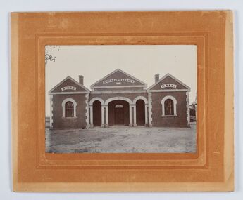 City of Greater Bendigo - Civic Collection
Photograph - Strathfieldsaye Shire Hall
The district of Strathfieldsaye was proclaimed in 1861 and named a Shire on the 17th September in 1866. It remained a shire until amalgamation in 1994 when it became part of the City of Greater Bendigo. The shire was located 8 km to the south- east of Bendigo and covered an area of 601 square kilometres and extended from the Calder Highway to the Coliban and Campaspe Rivers. The shire's administration activities were centred at the Strathfieldsaye Shire Hall which was built in 1869 at a cost of £700 based on a design by George Steane, the shire surveyor and built by George Pallett of Sandhurst. Constructed of red brick, the hall has a unique ventilation system with hollow walls open at the top and bottom to ensure a draught to cool the building in summer. Framed and mounted photograph of the Strathfieldsaye Shire Hall. Verso; W M Robinson / Photographer / Mundy Street Bendigostrathfieldsaye shire hall, shire of strathfieldsaye, strathfieldsaye shire council -
 Warrnambool and District Historical Society Inc.
Administrative record (Collection) - Grasmere cheese and Butter Factory Company Records, Grasmere Cheese and Butter Factory administrative employees, Records: Grasmere Cheese and Butter Factory, 1890-1959
Administrative Records of Grasmere Cheese and Butter Factory - source of collection unknown This collection of administrative records has been created for historical reasons and archival purposes.Items kept in two A2 size archival boxes in the Archives Room and stored in this way some years after the acquisition of these items at an unknown date.Four ledgers containing Minutes, two unbound packets of Minutes and one photographic supplement from a magazinegrasmere cheese and butter factory pty ltd, dairying in the warrnambool districtgrasmere cheese and butter factory pty ltd, dairying in the warrnambool district -
 The Beechworth Burke Museum
Photograph, Late 1800s
This photograph was taken during the late 1800s at the Chinese camp at Beechworth, Victoria. It was in camps such as these that many would-be gold miners made their home after arriving in Australia from across Asia. After arriving in South Australia where there was no poll-tax required of migrants as was the norm in Victoria and New South Wales, those looking to settle on the gold fields walked en mass overland for hundreds of kilometres before arriving in destinations such as Beechworth. Due to widespread prejudice against Chinese gold diggers they were forced to live separate from the town and developed enclaves much like the one depicted in the photograph. As the years progressed the Chinese camp began to construct more permanent structures and included temples of worship, shops and separate burial grounds. This photograph demonstrates the early multi-cultural aspects of Australia and Victoria during the late 1800s. It also showcases pressures and prejudices specific to the Chinese migrant community and the measures taken to separate them from the rest of the predominantly white community. It also reflects the gold-rush period and one of the first draws to Australia due to its mineral wealth. Black and white rectangular photograph developed on paperObverse: None Reverse: From the/Chinese Camp/84-80-1/1997-3221chinese camp, beechworth, houses, immigrants, gold mining, gold rush, late 1800s, chinese, asia -
 Warrnambool and District Historical Society Inc.
Book, The Rambler, 1942
These two items were sent in the 1940s to Tom Terrington of Framlingham ( about 28 kilometres north east of Warrnambool) from Donald Mackintosh. Tom Terrington (b. 1897) worked at various jobs until he took over the Framlingham store in the 1940s. He was a scholarly person with a wide knowledge of English literature. He wrote poetry and researched and wrote extensively on Framlingham history. Donald Mackintosh (1866-1951) was Australia’s first Olympic shooting gold medallist. He competed in trapshooting events all over the world, winning 30 gold medals, making a considerable amount of money and holding the world trapshooting championship title from 1903 to 1908. He was a keen photographer and wrote poetry under the name of ‘The Rambler’. This small folder is of great interest as it contains a poem sent to Tom Terrington by Donald Mackintosh (The Rambler). Tom Terrington is important in Framlingham’s history and his friendship with Donald Mackintosh, an Australian and world trapshooting champion and a poet is of considerable interest. The tone of the poem echoes also the despondency felt by Australians during the darkest days of World War Two. This is a piece of cream thickened paper folded in two with a typed copy of a poem pasted on the inside of the paper and a copy of a prose piece typed in ornate script and pasted on to a piece of cardboard and enclosed in the cream folder. Both of the typed items have handwritten messages at the bottom of the text. The cream folder is a little crumpled and stained. ‘The Rambler 1942-3’ ‘For T. Terrington from Dld Mackintosh with best wishes 1942-3’ tom terrington, donald mackintosh -
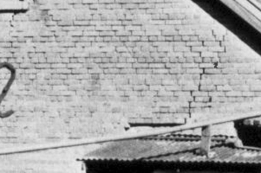 Greensborough Historical Society
Photograph - Digital Image, Brickwork, Willis Vale, 1950c
Close up photograph of a section of brickwork at Willis Vale. This is the end wall under the roof. Willis Vale built by Edward Maygar, Robert Whatmough lived there mid 19th century and later sold to Partington family. It was located on the Plenty River at Partington's Flat Greensborough. Land use included farming and orchards. The derelict Willis Vale house was vandalized in 1964 and destroyed when a fire originating from North Plenty Gorge - Kurrak Road - was lit by two teenage boys and made its way several kilometres down to Partington's Flat Greensborough. This photo was taken after the Partington's moved house in 1947 across the river where Alan built their new Alwyn house that had access to electricity.Part of Willis Vale, a pioneer home in the Greensborough area.Digital copy of black and white photograph.willis vale -
 Warrnambool and District Historical Society Inc.
Map - An Angler's map of the Hopkins River Estuary, Angler's map Hopkins River, 1980s
This is a map of the Hopkins River Estuary prepared by Dr John Sherwood for the benefit of anglers. The information on the sheet includes the location of sand banks, the water depths, boat ramp facilities and public access facilities. Some of the information has been gathered from aerial photographs. The map has been produced by the Warrnambool Institute of Advanced Education which was developed in the late 1960s from the tertiary section of the Warrnambool Technical College and with all its departments established by 1984 at the Sherwood Campus five kilometres from Warrnambool on the Princes Highway. Today the site is occupied by Deakin University, Warrnambool campus. The Warrnambool Anglers’ Club has its headquarters on the banks of the Hopkins River near the mouth of the river and the Lyndoch Aged Care facility.This map is of interest as a specialist one, providing fishermen with detailed information on all aspects of the Hopkins river estuary. Fishing has been both a profession and a popular recreational pursuit for Warrnambool residents since the early days of the city’s settlement. The Hopkins River Estuary has been a focal point for fishermen throughout Warrnambool’s history. This is a sheet of paper folded three times to produce a folded map. The front cover has a black and white photograph of two fishermen with a large fish. The map of the Hopkins River Estuary is in yellow, blue and black and covers the side of one sheet and three quarters of the other side. There is an advertisement for the Hopkins River Boathouse with a black and white sketch of the boathouse and notes on the map written by Dr John Sherwood. There are several diagrams showing the water depths. The map has some silverfish damage and some tearing at the folds. warrnambool anglers’ club, history of warrnambool, hopkins river, hopkins river estuary, john sherwood -
 Orbost & District Historical Society
cash book, first half 20th century
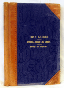
This ledger was used by the Shire of Orbost to record transactions relating bto the Newmerella Drainage Area from 1927 to 1950. The item was donated to Orbost & District Historical society from P.R.O.V. as a Place of Deposit (POD) item for safe keeping by a local history group or museum. The shire covered an area of 9,347 square kilometres and existed from 1892 until 1994 when it became part of the East Gippsland Shire Council. Orbost was at first included in the Bairnsdale Shire from 1882 and was later part of the Tambo Shire. Because of travelling distances the Croajingalong Shire was created in 1892 (name changed to Orbost Shire 17.2.1893 with James Cameron as the first Shire President. In 1994 it amalgamated to become part of East Gippsland Shire Council.This item is a hand-written record of the accounts of the Orbost Shire local government. It pre-dates computer records. The Orbost Shire Council no longer exists having been absorbed into the East Gippsland Shire Council. A ledger with a black cover and brown binding. It has marbled end covers. It contains handwritten records of transactions relating to the Newmerella Drainage Area. On the front cover in gold print is "LOAN CASH BOOK (underlined) NEWMERELLA DRAINAGE AREA ACCOUNT (underlined) SHIRE OF ORBOST". on spine - "Newmerella Drainage Area Cash Book" in gold print.orbost-shire-council ledger accounts newmerella-drainage-area -
 Federation University Historical Collection
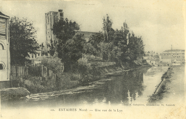
Postcard - black and white, Estaires, France, c1917, C1917
WW1 Australian soldier Holmes Famiiy memento. Estaires is a town and commune in the Department of the Nord, about 11 kilometres west of Armentieres. The Estaires Communal Cemetery and Extension is on the eastern outskirts of the town and on the east side of the road to Bailleul. Estaires town was occupied by French cavalry on the 15 October 1914, and passed at once into British hands. On the 10 April 1918 it was captured by the enemy, after an obstinate defence by the 50th (Northumbrian) Division; and it was finally retaken by British troops at the beginning of September 1918. The town was a Field Ambulance centre as early as November 1914, and later the 1st Australian Casualty Clearing Station was posted in it. (http://www.cwgc.org/find-a-cemetery/cemetery/26801/ESTAIRES%20COMMUNAL%20CEMETERY%20AND%20EXTENSION, accessed 11/07/2014)Australian soldier's WW1souvenirA black and white postcard with buildings along a river at Estaires in Northern France.estaires communal cemetery and extension, estaires, france, chatham-holmes family collection, 1st australian casualty clearing station, postcard