Showing 614 items
matching the state rivers
-
 Orbost & District Historical Society
black and white photographs, Snowy River Mail, 1990
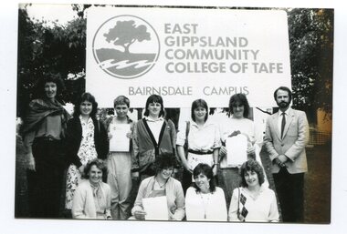
These photographs are related to adult Learning in Orbost.. They are connected to the "East Gippsland Community College of T.A.F.E. Bairnsdale Campus" The Orbost Education Centre has been in operation since 1976 and is run by a team of volunteers and paid staff. Programs and activities offered respond to the needs of the local community and the centre works closely with its community partners. It is supported by funding and goodwill from the community, state government and non-government organisations. TAFE offered adult education to those new out of school and mothers coming out of motherhood as well as others. In the photographs are: Janet Hambling; Irene Rowley; Clive Jenkins; Keith Knight; Wendy Major; Wendy Blackburn; Peter Bommer; Helen Shiels, Jeff Wilson and Peter Griebenow.These photographs are associated with Adult Learning in Orbost.Seven black / white photographs related to Adult Education in Orbost. education-adult-orbost t.a.f.e.-orbost -
 Ringwood and District Historical Society
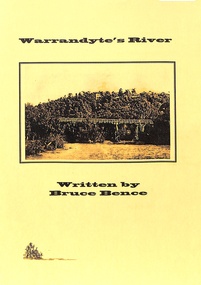
Book, Bruce Bence, Warrandyte's River, C. 1986
Historical information provided by state water, road, and metrological and local government authorities and local residents' reminicences of the Yarra River at Warrandyte. Includes table showing periodic significant flows of the river between 1863 and 1985. -
 Bendigo Military Museum
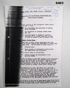
Administrative record - Use of Military maps for water supply planning, 1962
... State Rivers and water supply Commision, Division of National ...These are typed notes on the use of Military maps for water supply planning. This demonstrates the value of Military Mapping containing accurate relief information that can then be used for water supply planning.5 x A4 pages of typed notes, poorly photocopiedroyal australian survey corps, rasvy, fortuna, army survey regiment, army svy regt, asr, state rivers and water supply commission -
 Bendigo Military Museum
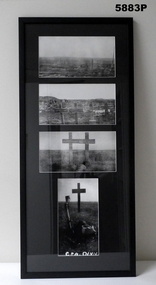
Photograph - PHOTOGRAPHS, GRINTON COLLECTION, FRAMED, 2008 - 2009
Frame 4. Photo 1. Curlu, Hem, Vaux area which can be seen written faintly at the bottom of the photo. These are 3 small villages near where Bert Grinton won his DCM. The villages are along the Somme River. The nearest towns of note are Mont St Quentin and Perrone. Photo 2. Four graves, left to right. 1. Lance Corporal George Grimshaw, No 887 38th Batt, KIA 28/8/1918 aged 24 years. He embarked with C Coy on the Runic and the embarkation rolls state that he was a farm labourer from Gasquil East Victoria. His final resting place is the Hem Farm Military cemetery, Hem Monacu. 2. Corporal Vincent Thomas Stanley Wyniat, No 709, 38th Batt, KIA 28/8/1918 aged 28 years. h embarked with D Coy on the Runic and the embarkation rolls state that he was a labourer of Edenhope, Vic. His final resting place is also Hem Farm. 3. Two graves left to right. Private W McEwan, No 7067, 38th Batt, KIA 31/8/1918 aged 36 years. He was actually William Lowrie Allison from NSW enlisting under the name McEwan. His final resting place is the Perrone Communal Cemetery Extension. he is buried there under the name "Allison". Private Norman John Warren Hoffmeyer, No 2339, 38th Batt, KIA 31/8/1918 aged 23 years. He embarked with the 4th reinforcements to the 38th per HMAT A17 Port Lincoln on 20/10/1916. The embarkation rolls state that he was a farmer from Bendigo, Victoria. His final resting place is also Perrone. 4. Single grave. Private Cyril Edmund Andrew Dunn, No 3058, 38th Batt, KIA 31/8/1918 aged 22 years. He embarked with the 7th reinforcements to the 38th Batt per the HMAT A70 Ballarat on 19/2/1917. the embarkation rolls state that he was a Bank Clerk of East St Kilda. His final resting place is Hem Farm Military Cemetery, Hem Monacu. From other negatives we have identified some 15 graves. All these soldiers were KIA over the period 26 - 31 August 1918. This was during the time Bert won his DCM. Within a month Jack and Bert's Company was down to 20 men. Refer Cat No. 5880P for exhibition details. Refer Cat No. 1280 for Jack GRINTON Service Records. Photographs - black and white on paper. Four photographs, top to bottom. 1. Scene with a village. 2. 4 graves with crosses. 3. 2 graves with crosses. 4. single grave with cross and rifle. Frame - timber with black colour paint, glass front. Mount - black colour cardboard. Backing cardboard with handwritten notation.Backing cardboard, handwritten black felt tip pen "4."framed photographs, grinton collection, ww1, 38th -
 Warrnambool and District Historical Society Inc.
Map, Soil conservation authority:plan of high water marks at Lady Bay Warrnambool, 1984
This map documents the changing state of Lady Bay from around 1870 until 1976. It depicts the changing high water mark over that period and the main outlet of the Merri River in 1872 and 1976.This map provides a useful and significant insight into the ever changing face of Lady Bay from the 1870’s through to 1980’s. Cream paper map drawn with black ink showing Lady Bay and South Warrnambool section of Warrnambool. In lower RH corner Soil conservation AuthorityPlan of High water marks at Lady Bay Warrnambool. Drawn P.D. 19.1/84. Scale 1:3600. Written on back in black pencil: Lady Bay Historical HWM lady bay map, merri river 1872- 1976, merri river 1872- 1976, history of warrnambool -
 Warrnambool and District Historical Society Inc.
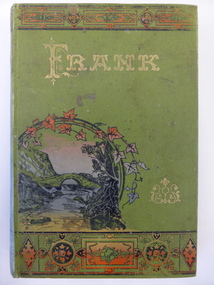
Book, Frank, Late 19th century
This book was given as a prize in 1892 to Joseph Cassady from the Cassady’s Bridge State School. This school, once located near Cassady’s Bridge on the present-day Caramut Road, was opened on 19th January 1891 and closed in December 1892. The first teacher was Janet Ada McDougall and the teacher when the school closed was J. H. Delahenty. The Cassady family had the farm, Boughton and this was established about 1845 on the Merri River near where the bridge is today. Joseph was born in 1882 to William and Elizabeth Cassady.This book is of considerable importance as it is the only memento we have of Cassady’s Bridge State School. This school only existed for two years.This is a hard cover book of 208 pages. The cover is green with coloured borders and a coloured sketch of a stream and a bridge. The lettering on the front cover and the spine is gold and the pages are gilt-edged. The cover is much faded. Some of the back pages are partly torn away. The book has two black and white sketches at the front of the book and 28 chapters of story. The inscription is handwritten in black ink and the inscription page is stained. ‘State School Cassady’s Bridge Xmas 1892 Presented to Joseph Cassady 3rd Class for Good Progress. J.H. Delahenty Head Teacher’ cassady family, boughton, history of warrnambool -
 Kiewa Valley Historical Society
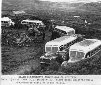
Photograph - Parlimentary Party visiting Rocky Valley Dam site, 15-4-1948
This photograph was taken during construction of the Rocky Valley Dam and wall. Work was commenced in early 1947 but had to be suspended during winter and then resumed in October. Work continued in 1948 with the establishment of work facilities and, at the dam site, the river was diverted through a temporary pipeline. Rocky Valley and associated spillway and outlet works were completed in 1959.A pictorial record of the construction of the rock and earth filled dam wall at Rocky Valley. Shows the extent of the project undertaken and the level of importance of the project as indicated by the large representation at the parliamentary party visit on 15/4/48.Photocopy of black and white photograph of parliamentary party visiting Rocky Valley Dam site 15/04/1948Typed on the bottom of photocopy - State Electricity Commission of Victoria. Date: 15-4-48 Time: 4.30pm No: K4397. Kiewa Hydro-Electric works. Parlimentary Party at Rocky Valleyrocky valley dam, parliamentary party, secv -
 Kiewa Valley Historical Society
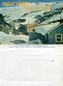
Souvenir Postcard Folder – Falls Creek Ski Village
... was started in the Kiewa River valley by the State Electricity... in the Kiewa River valley by the State Electricity Commission ...After World War II, the Kiewa Hydroelectric Scheme was started in the Kiewa River valley by the State Electricity Commission of Victoria. On land previously used only for summer cattle grazing in the natural alpine grasslands, the first ski lodge was built in 1948 by workers from the scheme. The first lift, a rope tow, was built in 1951 and the first chairlift in Australia was constructed there in 1957. Falls Creek Post Office opened on 9 June 1958 (with telegraph and telephone facilities only until 1964) .Despite strong opposition from the head of the Kiewa scheme, who didn't want tourists clogging up his roads and destroying his "dry" construction camps by bringing in booze, Falls Creek boomed as much as Hotham, partly owing to its relatively good access road. Early lodges included Bogong (c.1946), Skyline (1947), Albury (1949), Myrtleford (1949) and Dawn (c.1950).The souvenir postcard photographed and produced by an enterprising local businessman Mr S K Pearce, was produced as a memento for skiers and other visitors to the Falls Creek and Mt Beauty area to send to family and friends as a reminder of their visit to the region, or to keep as a personal souvenir. It presented an excellent promotional opportunity for enterprising local businessmen to promote the area to skiers and tourists near and far. It also presents an excellent pictorial history of the falls creek area around the late 1950’s to early 1960’sColour postcard folder (unused) containing 13 photographs of the Falls Creek ski area and surrounds. Inside cover has a brief description of the area and the services available to visitors Printed on front cover- FALLS CREEK SKI VILLAGE. Your Souvenir Folder Photo of skiing slopes of the village Inside front flap - a brief description of the Falls Creek area and the services available to visitors 1. Diana Lodge parking area and Spion Kopje 2. Winterhaven Lodge 3. Ski Hirage Centre and skiing slopes 4. Ski Lodges from main road 5. Nelse and Arundel Lodges 6. Day visitors’ shelter and parking area 7. Summit T-Bar lift 8. Spur T-bar looking towards Village and Spion Kopje 9. T-bar lower station and Snow Crystal Inn 10. ‘Akja’ rescue sled in use 11. Falls Creek road and Grand Coeur Lodge annex 12. Rope tows and beginner slopes 13. Back cover- Published by Nucolorvue Pty Ltd Mentone Vic. Printed in Australia For S.K.Pearce Pty Ltd Tawonga and Mt Beauty falls creek, snow, bogong high plains, victorian alps -
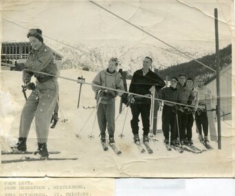 Kiewa Valley Historical Society
Photographs – Skiers at Falls Creek – Set of 10 black and white photographs
... was started in the Kiewa River valley by the State Electricity... in the Kiewa River valley by the State Electricity Commission ...After World War II, the Kiewa Hydro-Electric Scheme was started in the Kiewa River valley by the State Electricity Commission of Victoria. On land previously used only for summer cattle grazing in the natural alpine grasslands, the first ski lodge was built in 1948 by workers from the hydro scheme as skiing was a popular recreation. Many of the hydro employees were of European background and had grown up enjoying skiing and snow sports in their homelands and were keen to continue to pursue their winter sports interests. The first lift, a rope tow, was built in 1951 and the first chairlift in Australia was constructed there in 1957. Two T-Bars were opened in 1961. In 1964, the Victorian Municipal Directory recorded that Falls Creek had 29 ski club lodges and 16 commercial lodges.Employees of the State Electricity Commission of Victoria in the Kiewa River Valley were the earliest skiers on the Bogong High Plains and built one of the first ski lodges at Falls Creek. They were amongst those pivotal in the development of the skiing and tourist industry at Falls Creek and on the Bogong High Plains. Set of 10 black and white photographs of various skiers at Falls Creek Victoria1. From Left-John Robertson Myrtleford; Bill Bridgford, St Trinians; Girl not known; Roy Wolpole, Myrtleford; Fin McAuliffe, Myrtleford; Looking on foreground, Toni St Elmo 2. Falls Creek. Property of State Electricity Commission of Victoria Publicity Photo Negative No PB4046. Publicity Branch, 15 William St Melbourne. 3. Avic Lajons 4. No markings 5. Bill Bridgeford (lower person on slope) 6. Max Lawrence? Facing skiers 7. 6575. Indistinguishable red stamp on back 8. 6875. Ces Dobson on tractor 9. From left on tow. John Robertson (Myrtleford); Bill Bridgeford (St Trinians); Girl unknown; Roy Walpole (Myrtleford); Vin McAuliffe (Myrtleford); Looking on foreground Toni Beveridge. 10. From Left 1; 2; 3. Bill Bridgeford; 4. George McPherson ? (Myrtleford); 5. John Robertson (Myrtleford); 6. Elsbeth Rollenson? (Myrtleford); 7; 8; 9. 11. Bogong. Looking N.E from Big River fire track. Skiers on way to Falls Creek. Spion Kop on left. Going around Ropers Cerner near the 18 mile post falls creek, skiing, bogong high plains -
 Kiewa Valley Historical Society
Photographs –Collection of 10 copies and original black and white photographs and printed articles relating to skiing on the Bogong High Plains
... was started in the Kiewa River Valley by the State Electricity... in the Kiewa River Valley by the State Electricity Commission ...After World War II, the Kiewa Hydro-Electric Scheme was started in the Kiewa River Valley by the State Electricity Commission of Victoria. On land previously used only for summer cattle grazing in the natural alpine grasslands, the first ski lodge was built in 1948 by workers from the hydro scheme as skiing was a popular recreation. Many of the hydro employees were of European background and had grown up enjoying skiing and snow sports in their homelands and were keen to continue to pursue their winter sports interests. The first lift, a rope tow, was built in 1951 at Falls Creek and the first chairlift in Australia was constructed there in 1957. Two T-Bars were opened in 1961. In 1964, the Victorian Municipal Directory recorded that Falls Creek had 29 ski club lodges and 16 commercial lodges. The area became a popular tourist destination for both winter and summer sports.: Employees of the State Electricity Commission of Victoria in the Kiewa River Valley were the earliest skiers on the Bogong High Plains and built one of the first ski lodges at Falls Creek. They were amongst those pivotal in the development of the skiing and tourist industry at Falls Creek and on the Bogong High Plains. Collection of 10 copies and original black and white photographs and printed articles relating to skiing on the Bogong High Plains. Some pieces have been enlarged to A3 poster size copies for display purposes 1. Copy of black and white photograph of group of skiers at Falls Creek 2. Copy of photograph of early skier on Bogong High Plains with temporary buildings and tents in the background 3. Copy of photograph of 3 skiers on Mt McKay 4. Copy of SECV photograph of Rocky Valley Camp under snow 5. Early sepia photograph of Falls Creek village with skiers in the foreground 6. Copy of a page from booklet (SECV?) promoting the benefits of owning a holiday home in the Bogong Village area 7. Copy of a page from booklet (SECV?) promoting the benefits of holidaying in and around Falls Creek/Mt Beauty 8. Panoramic view of ski fields with skis in the foreground 9. Photograph of young skier (identity unknown) 10. Photograph of 2 male skiers (identity unknown) performing a small jump 1. Bogong Ski Club Members & Friends 1944 2. Jack Neve – electrician. Rocky Valley 3. 17.5.55 Skiers ascending Mt McKay 4. State Electricity Commission of Victoria. Date:17.8.55 No:K8132 Kiewa Hydro Electric Works. Rocky Valley Camp – From Engineering Office 5 & 9 No markings 6 & 7 Short article relating to photos on each page 8. Handwritten signature on rear of photo (Sandra Conea) 10 Faded unreadable photographers stamp and handwritten numbers 6875 on rear secv; bogong high plains; skiers; falls creek; tourism -
 Kiewa Valley Historical Society
Photographs – Bogong High Plains - Set of 16 black and white photographs mounted back and front on 3 pieces of heavy black card likely removed from a photograph album
... was started in the Kiewa River Valley by the State Electricity... in the Kiewa River Valley by the State Electricity Commission ...After World War II, the Kiewa Hydro-Electric Scheme was started in the Kiewa River Valley by the State Electricity Commission of Victoria. On land previously used only for summer cattle grazing in the natural alpine grasslands, the first ski lodge was built in 1948 by workers from the hydro scheme as skiing was a popular recreation. Many of the hydro employees were of European background and had grown up enjoying skiing and snow sports in their homelands and were keen to continue to pursue their winter sports interests. The first lift, a rope tow, was built at Falls Creek in 1951 and the first chairlift in Australia was constructed there in 1957. Two T-Bars were opened in 1961. In 1964, the Victorian Municipal Directory recorded that Falls Creek had 29 ski club lodges and 16 commercial lodges. The area became a popular tourist destination for both winter and summer sports.Employees of the State Electricity Commission of Victoria in the Kiewa River Valley were the earliest skiers on the Bogong High Plains and built one of the first ski lodges at Falls Creek. They were amongst those pivotal in the development of the skiing and tourist industry at Falls Creek and on the Bogong High Plains. Black and white photographs of varying sizes mounted decoratively on heavy black Card. Some pages display a brief description printed in white ink 1. 4 photographs- displayed diagonally across page. 2 pictures of a group of men standing in the snow in front of a car with a loaded trailer behind. 1 photo of skiers. 1 photo of show hanging in tree branches. 2. 2 photographs- showing Upper Kiewa Road with snow in the background 3. 3 photographs- of skiers and 1 photo of 2 of men posing in the snow & 1 photo of 2 men posing shirtless in warmer weather. 4. 2 photographs- arranged diagonally on page showing early buildings and construction at Bogong Village 5. 2 photographs- 1 showing view of Bogong Village from higher up the mountain. 1 showing early Bogong High Plains road 6. 1 photograph- showing view down along Kiewa Valley from higher up in the mountains 1. Handwritten in white ink – A TRIP TO THE PLAINS 2. Handwritten in white ink – UPPER KIEWA ROAD MT FAINTER IN BACKGROUND 3 – 6. No markings bogong village; upper kiewa road; bogong high plains; falls creek; skiers -
 Kiewa Valley Historical Society
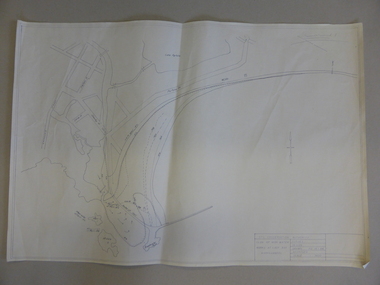
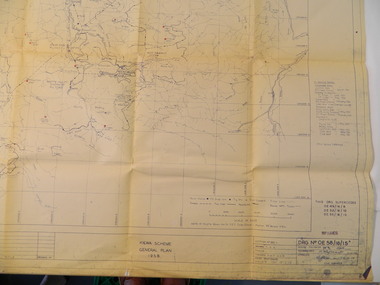
Plan - Kiewa Scheme General Plan 1958, S.E.C.V. Design & Construction Dept. Civil Branch, Dec. 1958
The Kiewa Hydro Electric Scheme was constructed by the State Electricity Commission of Victoria. Draftsmen drew up the plan of the layout as per the instructions from the engineers. The plan was drawn up on a transparency sheet and paper prints run off on a 'dyeline' copier. The 'Chief draftsman' and 'Design engineer' and 'Civil engineers recommended it and approved it. Historic: This plan gives a time line for the work on the Kiewa Hydro Electric Scheme. It is a good example of the work of a draftsman and the copying process in 1958.Large topography map of the area covered by the Kiewa Hydro Electric Scheme in 1958. Mountain peaks are marked in red and named. Rivers, roads, construction infrastructure as well as the main areas / names of construction are named. Signed and dated by employees of the S.E.C.V. working on the scheme.state electricity commission of victoria., kiewa hydro electric scheme, plan, engineer, draftsman -
 Kiewa Valley Historical Society
Four photographs of the Blue Duck Hotel and two Photos of the Glen Wills area, c1920 Post cards, c1949/50 small photographs
The Blue Duck Hotel stands at the confluence of 3 trout rivers - Cobungra, Bundarra and Mitta Mitta, called Angler's Rest. The original 1900's building was of slab construction and operated as a butcher shop, servicing miners on the track from Omeo to Mt. Wills. In 1912 it was purchased by a miner, Billy O'Connell, and he obtained a hotel license. In the early 1920's he transported 2 houses from Omeo on Horse drays. One is the main building of the Blue Duck and the other was a residence where Billy and his wife raised their nine children. The small log structure behind the pub is State School No.4286 where the children attended school. A teacher was shared with Glen Wills. By the late 1920's the hotel was discovered and patronized by keen anglers. Sir Harold Clapp (head of the railways) was one and he had the bronze blue duck cast and presented to the owners in the 1930's. This stands at the entrance to the premises.These photographs are of a building, in a remote area, that has provided a service to miners, anglers and travellers for over 100 years and continues to do so today. It also played a vital role in the history of the Mt. Wills/Omeo gold mining days.3 Post cards, Black and White photographs. 3 small black and white photographsPost Card No. 1 - "Blue Duck Hotel- Omeo-Glen wills road Ray Love Series No.2"(written on lower front) Post Card No. 2- "Looking towards Bogong High Plains. Omeo-Glen Wills road"(front, bottom, L hand) Ray Love Series No. 18 (front, lower R hand corner) On both of above photos, centre back, is stamped POST CARD and underneath this is printed "A GENUINE PHOTOGRAPH'/ Post Card No. 3 - Bottom L hand corner "Mystic Sea Australian Alps". R hand corner "(Bulmer Copyright)". Each small photograph, handwritten on back "Blue duck Hotel". All have circular stamp with "Print by Wilson White Albury" blue duck hotel; anglers rest; omeo highway; fishing; mining -
 Kiewa Valley Historical Society
Photograph - Folder of Photographs (KVHS 1150 A - F) – Photocopied set of black and white photographs from the display folder (pages 1 - 8) put together by KVHS to document life on the Kiewa Valley Hydro-electric Scheme
Although the Kiewa Hydro-Electric Scheme was first proposed in 1911, construction did not commence until 1938. As part of the push to cut electricity costs and diversify supply, the Victorian Government (circa 1930) initiated the conversion from primarily brown coal supply to hydro – electricity. Field investigations during the 1940’s resulted in a new proposal for a scheme that had more than double the capacity of the 1938 scheme. The Kiewa Hydroelectric Scheme became the largest scheme of its kind in the State Of Victoria and the second largest scheme in Australia. The number of personnel involved in the planning and construction of the scheme increased dramatically. During the late 1940’s, most activity centred around the construction of the West Kiewa Power Station, Rocky Valley Reservoir, McKay Creek Power Station and the Bogong Creek Aqueduct.A common thread across all the larger hydro scheme constructions was the need for workers, both qualified and unqualified who came from around the world seeking a new life for themselves and their families. New accommodation and facilities were required for the army of workers engaged in construction in often remote and wild areas. The SEC had a high demand for timber, and set up the first of a number of sawmills at Bogong Creek in 1939 and set up the first hardwood logging in the headwaters of the Kiewa River. These new ‘towns’ such as Mt Beauty and Bogong, survived, serving the needs of operational personnel and their families, and expanding with growth of new industries. Mount Beauty, and to a lesser extent Bogong, are among these places. Large A3 size spiral bound display folder containing 21 of 58 pages of photocopied black and white photographs of various aspects of the early days of the Kiewa Valley Hydro-electric scheme including equipment, various work sites and photographs of workers and their families. 1-Front page; 2-Security gate at Mt Beauty Camp; 3-Channel 1 on East Kiewa River; 4-Junction Dam – Diversion Tunnel Inlet; 5-Sawmill; 6- Homan’s Gap Sawmill; 7 Junction Dam: 8-Homan Dam Site-Diamond Drilling on River Buttress; 9- Homan Dam Site View Upstream 10-Homan Dam Investigation Camp 1-Windsor & Newton Visual Diary 60 sheet (120 pages) 11’ x 14’ 280 x 356mm 110 GSM Acid Free Drawing Paper 2-1940-Security Gate on Mt Beauty side of Kiewa River bridge. Part of old Mt Beauty camp and mess in background 3- STATE ELECTRICITY COMMISSION OF VICTORIA Date; 11.3.40 Time: 10.30am No K35 Kiewa Hydro Electric Works. Diverting East Kiewa River into Channel Page number 1 4-STATE ELECTRICITY COMMISSION OF VICTORIA Date: 5.4.40 Time: Noon No K58 Kiewa Hydro Electric Works. Junction Dam – Diversion Tunnel Inlet – Normal Flow Page number 2 5- STATE ELECTRICITY COMMISSION OF VICTORIA Date: 19.8.42 Time: 2.30pm No K883 Kiewa Hydro Electric Works. Sawmill – General View Page number 3 6- STATE ELECTRICITY COMMISSION OF VICTORIA Date: 12.1.42 Time: 2.00pm No K540 Kiewa Hydro Electric Works. Homan’s Gap Sawmill – General View Page number 4 7- STATE ELECTRICITY COMMISSION OF VICTORIA Date: 12.1.42 Time: 2.00pm No K540 Kiewa Hydro Electric Works. Junction Dam – General View looking upstream Page number 5 8- STATE ELECTRICITY COMMISSION OF VICTORIA Date: 16.11.45 Time: 10.32amm No K52153 Kiewa Hydro Electric Works Homan Dam Site – Diamond Drilling on River Buttress Page number 6 9-STATE ELECTRICITY COMMISSION OF VICTORIA Date: 15.1.45 Time: 4.10pm No K1781 Kiewa Hydro Electric Works Homan Dam Site – View Upstream Page number 7 10- STATE ELECTRICITY COMMISSION OF VICTORIA Date: 15.1.45 Time: 4.10pm No K1781 Kiewa Hydro Electric Works Homan Dam Investigation Camp 1944 – 1945 Page number 8 secv; kiewa hydro electric scheme; mt beauty; bogong; construction work; -
 Kiewa Valley Historical Society
Photograph - Folder of Photographs – Photocopied set of black and white photographs (pages 9 - 18) from the display folder put together by KVHS to document life on the Kiewa Valley Hydro-electric Scheme
Although the Kiewa Hydro-Electric Scheme was first proposed in 1911, construction did not commence until 1938. As part of the push to cut electricity costs and diversify supply, the Victorian Government (circa 1930) initiated the conversion from primarily brown coal supply to hydro – electricity. Field investigations during the 1940’s resulted in a new proposal for a scheme that had more than double the capacity of the 1938 scheme. The Kiewa Hydroelectric Scheme became the largest scheme of its kind in the State Of Victoria and the second largest scheme in Australia. The number of personnel involved in the planning and construction of the scheme increased dramatically. During the late 1940’s, most activity centred around the construction of the West Kiewa Power Station, Rocky Valley Reservoir, McKay Creek Power Station and the Bogong Creek Aqueduct.A common thread across all the larger hydro scheme constructions was the need for workers, both qualified and unqualified who came from around the world seeking a new life for themselves and their families. New accommodation and facilities were required for the army of workers engaged in construction in often remote and wild areas. The SEC had a high demand for timber, and set up the first of a number of sawmills at Bogong Creek in 1939 and set up the first hardwood logging in the headwaters of the Kiewa River. These new ‘towns’ such as Mt Beauty and Bogong, survived, serving the needs of operational personnel and their families, and expanding with growth of new industries. Mount Beauty, and to a lesser extent Bogong, are among these places. PHYSICAL: Large A3 size spiral bound display folder containing 21 pages of photocopied black and white photographs of various aspects of the early days of the Kiewa Valley Hydro-electric scheme including equipment, various work sites and photographs of workers and their families. 1-Bridge across Tailrace Channel 1946 2-New Mess building, Mt Beauty 3-Homan’s Gap Saw Mill 4- Diamond Drilling Plant – Big Hill 5-Rocky Valley Camp-Mess Building 6-Parlimentary Party at Rocky Valley 7-No.4 Headrace Tunnel 8- Allis-Chalmers Tractor School 9- SECV Heavy Machinery lined up by road 10- No. 5 Raceline – Balasting Track with improvised truck 1-1946 – Bridge across tailrace channel Page number 9 2-New mess building, Mt Beauty 6.4.46 Page number 10 3- STATE ELECTRICITY COMMISSION OF VICTORIA Date: 10.1.47 Time: 11.40am No K2271 Kiewa Hydro Electric Works Homan’s Gap Saw Mill – Rip Saw Page number 11 4- STATE ELECTRICITY COMMISSION OF VICTORIA Date: 5.10.47 Time: 11am No K4111 Kiewa Hydro Electric Works Diamond Drilling Plant – Big Hill Page number 12 5- STATE ELECTRICITY COMMISSION OF VICTORIA Date: 11.2.48 Time: 3pm No K4277 Kiewa Hydro Electric Works Rocky Valley Camp-Mess Building Page number 13 6- STATE ELECTRICITY COMMISSION OF VICTORIA Date: 15.4.48 Time: 4.30pm No K4397 Kiewa Hydro Electric Works Parlimentary Party at Rocky Valley Page number 14 7- STATE ELECTRICITY COMMISSION OF VICTORIA Date: 22.8.48 Time: 9am No K4668 Kiewa Hydro Electric Works General view of No.4 Headrace Tunnel Page number 15 8-STATE ELECTRICITY COMMISSION OF VICTORIA Date: 5.9.49 Time: 10am No K5180 Kiewa Hydro Electric Works Allis-Chalmers Tractor School – HD 19, Mr I Crossthwaite at Controls Page number 16 9- No markings Page number 17 10- STATE ELECTRICITY COMMISSION OF VICTORIA Date: 7,12.49 Time: 4pm No K5423 Kiewa Hydro Electric Works No. 5 Raceline – Balasting Track with improvised truck. Page number 18 secv; kiewa hydro electric scheme; mt beauty; bogong; construction area -
 Kiewa Valley Historical Society
Photograph - Folder of Photographs – Photocopied set of 10 black and white photographs (pages 19 - 28) from the display folder put together by KVHS to document life on the Kiewa Valley Hydro-electric Scheme
Although the Kiewa Hydro-Electric Scheme was first proposed in 1911, construction did not commence until 1938. As part of the push to cut electricity costs and diversify supply, the Victorian Government (circa 1930) initiated the conversion from primarily brown coal supply to hydro – electricity. Field investigations during the 1940’s resulted in a new proposal for a scheme that had more than double the capacity of the 1938 scheme. The Kiewa Hydroelectric Scheme became the largest scheme of its kind in the State Of Victoria and the second largest scheme in Australia. The number of personnel involved in the planning and construction of the scheme increased dramatically. During the late 1940’s, most activity centred around the construction of the West Kiewa Power Station, Rocky Valley Reservoir, McKay Creek Power Station and the Bogong Creek Aqueduct.A common thread across all the larger hydro scheme constructions was the need for workers, both qualified and unqualified who came from around the world seeking a new life for themselves and their families. New accommodation and facilities were required for the army of workers engaged in construction in often remote and wild areas. The SEC had a high demand for timber, and set up the first of a number of sawmills at Bogong Creek in 1939 and set up the first hardwood logging in the headwaters of the Kiewa River. These new ‘towns’ such as Mt Beauty and Bogong, survived, serving the needs of operational personnel and their families, and expanding with growth of new industries. Mount Beauty, and to a lesser extent Bogong, are among these places. Large A3 size spiral bound display folder containing 21 pages of photocopied black and white photographs of various aspects of the early days of the Kiewa Valley Hydro-electric scheme including equipment, various work sites and photographs of workers and their families. 1-Allis Chalmers Tractor School 2- Gardens outside Administrative Office – Mt Beauty 3- Mt Beauty house – 1950 4-Bridge over Pretty Valley River, Bogong 5-Rocky Valley Spillway Tunnel break through 6-Ni 1 Headrace Tunnel drilling face 7-No 4 Power Station Drilling 8-Clover Dam Flood Waters 9-No1 Head Race Tunnel Portal Building 10-Clover Dam 1-STATE ELECTRICITY COMMISSION OF VICTORIA Date: 5.9.49 Time: 10amm No K5174 Kiewa Hydro Electric Works Allis Chalmers Tractor School Page number 19 2-STATE ELECTRICITY COMMISSION OF VICTORIA Date: 22.2.50 Time: 3.30pm No K5601 Kiewa Hydro Electric Works Gardens outside Administrative Office – Mt Beauty Page number 20 3-Mt Beauty house – 1950 Page number 21 4-STATE ELECTRICITY COMMISSION OF VICTORIA Date: 23.10.50 Time: 11.15am No K6331 Kiewa Hydro Electric Works Bogong-Bridge over Pretty Valley River Page number 22 5-STATE ELECTRICITY COMMISSION OF VICTORIA Date: 23.6.50 Time: 2.30pm No K5844 Kiewa Hydro Electric Works ROCKY VALLEY SPILLWAY TUNNEL BREAK THROUGH Page number 23 6-20/3/52 – No. 1 Headrace Tunnel Drilling face (E.E.E. contract) Page number 24 7-6/6/52 – No 4 Power Station – Drilling Page number 25 8-STATE ELECTRICITY COMMISSION OF VICTORIA Date: 6/6/52 Time: No K7113 Kiewa Hydro Electric Works Clover Dam Flood Waters Page number 26 9-STATE ELECTRICITY COMMISSION OF VICTORIA Date: Oct 1952 Time: No K7239 Kiewa Hydro Electric Works No. 1 HEAD RACE TUNNEL PORTAL BUILDING. Handwritten underneath – This information from Ron White-the later Principal Hydro Engineer of the SEC. Oct 1952 Location incorrect? All work on No 1 had ceased after financial crash of 1951. This photo would refer to No 4 Headrace Tunnel? Page number 27 10-STATE ELECTRICITY COMMISSION OF VICTORIA Date: Jan 1953 Time: No K7307 Kiewa Hydro Electric Works CLOVER DAM Page number 28 secv; kiewa hydro electric scheme; bogong; mt beauty; construction area -
 Kiewa Valley Historical Society
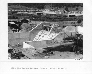
Photograph - Folder of Photographs – Photocopied set of 10 black and white photographs (pages 29 - 38) from the display folder put together by KVHS to document life on the Kiewa Valley Hydro-electric Scheme
Although the Kiewa Hydro-Electric Scheme was first proposed in 1911, construction did not commence until 1938. As part of the push to cut electricity costs and diversify supply, the Victorian Government (circa 1930) initiated the conversion from primarily brown coal supply to hydro – electricity. Field investigations during the 1940’s resulted in a new proposal for a scheme that had more than double the capacity of the 1938 scheme. The Kiewa Hydroelectric Scheme became the largest scheme of its kind in the State Of Victoria and the second largest scheme in Australia. The number of personnel involved in the planning and construction of the scheme increased dramatically. During the late 1940’s, most activity centred around the construction of the West Kiewa Power Station, Rocky Valley Reservoir, McKay Creek Power Station and the Bogong Creek Aqueduct.A common thread across all the larger hydro scheme constructions was the need for workers, both qualified and unqualified who came from around the world seeking a new life for themselves and their families. New accommodation and facilities were required for the army of workers engaged in construction in often remote and wild areas. The SEC had a high demand for timber, and set up the first of a number of sawmills at Bogong Creek in 1939 and set up the first hardwood logging in the headwaters of the Kiewa River. These new ‘towns’ such as Mt Beauty and Bogong, survived, serving the needs of operational personnel and their families, and expanding with growth of new industries. Mount Beauty, and to a lesser extent Bogong, are among these places. Large A3 size spiral bound display folder containing 21 pages of photocopied black and white photographs of various aspects of the early days of the Kiewa Valley Hydro-electric scheme including equipment, various work sites and photographs of workers and their families. 1-Mt Beauty Pondage inlet-Regulating weir 2-Langfords Gap Basalt Hill-Tunnel in quarry face.3-Rocky Valley Camp-from Engineering Office 4-Basalt Hill tunnel portal 5-No 1 Pressure Shaft Works Bench 6-No 1 Power Station 7-Overturned haulage wagons on the side of an embankment 8- Group of workers dressed in wet weather gear inside a tunnel 9-Workmen and vehicle in tunnel 10-Howman’s Gap campsite at 4,150 feet 1-1954 – Mt Beauty Pondage inlet – Regulating weir Page number 29 2-28/10/54 – Langfords Gap Basalt Hill – Tunnel in quarry face K7860 Page number 30 3-STATE ELECTRICITY COMMISSION OF VICTORIA Date: 17.8.55 Time: No K8132 Kiewa Hydro Electric Works ROCKY VALLEY CAMP – FROM ENGINEERING OFFICE Page number 31 4-28/10/54 – Basalt Hill tunnel portal K7859 Page number 32 5-No.1 Pressure Shaft Works Bench 5.7.56 Page number 33 6- No. 1 Power Station 26.4.59 Page number 34 7- No markings Page number 35 8-No markings (Wooden board on ground printed with - POLAR A.N.GELATINE DYNAMITE “75” DE 28.8.40) Page number 36 9-No markings Page number 37 10-Howman’s Gap campsite at 4,150 feet Page number 38 secv; kiewa hydro electric scheme; mt beauty; bogong; construction area -
 Kiewa Valley Historical Society
Postcard Circa 1950, Snow Plough, Bogong High Plain,5,500 Feet Kiewa Hydro-Electric Project, Circa 1950
This postcard was produced in the 1950's for the tourist trade in the Kiewa Valley and Alpine region. It encompasses the period when the State of Victoria was pressured by the ever increasing demand by industry and its population for electricity supplies. Hydro electricity was seen as an untapped natural resource to quench this demand. The Victorian Alps and the rivers flowing into its valleys was ideal for the construction of the Kiewa Hydro Electricity Scheme. The late 1940's saw the development of this scheme and the changing of sections of alpine landscape is covered by this and other postcards/pictures (tourists, construction workers, and established rural populations). This period in time was before the established wildlife and forest/nature groups became political activist who changed legislative acts to protect the environment. This rural region (Kiewa Valley/alpine plains) was at most only significant to a smaller group of winter sports, summer hikers/horse riders and rural farmers/graziers. The numbers of tourists and the increase in the local resident population was boosted by the construction of the Hydro Electricity Scheme. This influx to the regional population resulted in a corresponding diversity in services and brought about an environment that responded to a growing level of tourists and thereby permitting this industry to grow more rapidly than it would have naturally. This postcard details an attraction to the "cleaner" method of providing electricity. This postcard was purchased in 1950 by a surveyor at Landford's Gap. This item is a black and white photograph(professional) of a panoramic view of a snow plough clearing the unsealed road in 1950.This postcard is on quality paper and the reproduction of the picture is of a high standard.For other "tourist" postcards see 0480 (A) -(F) for other photos of similar postcards. kiewa valley tourism, victorian alps, alternate energy supplies, alpine population growth, secv, snow plough -
 Kiewa Valley Historical Society
Postcard Circa 1950, Road to Bogong High Plains Kiewa Hydro Electric Project, Circa 1950's
This postcard was produced in the 1950's for the tourist trade in the Kiewa Valley and Alpine region. It encompasses the period when the State of Victoria was pressured by the ever increasing demand by industry and its population for electricity supplies. Hydro electricity was seen as an untapped natural resource to quench this demand. The Victorian Alps and the rivers flowing into its valleys was ideal for the construction of the Kiewa Hydro Electricity Scheme. The late 1940's saw the development of this scheme and the changing of sections of alpine landscape is covered by this and other postcards/pictures (tourists, construction workers, and established rural populations). This period in time was before the established wildlife and forest/nature groups became political activist who changed legislative acts to protect the environment.This rural region (Kiewa Valley/alpine plains) was at most only significant to a smaller group of winter sports, summer hikers/horse riders and rural farmers/graziers. The numbers of tourists and the increase in the local resident population was boosted by the construction of the Hydro Electricity Scheme. This influx to the regional population resulted in a corresponding diversity in services and brought about an environment that responded to a growing level of tourists and thereby permitting this industry to grow more rapidly than it would have naturally. This postcard details an attraction to the "cleaner" method of providing electricity. This postcard was purchased in 1950 by a surveyor at Landford's Gap.This black and white photograph on a Valentine's postcard is from a V2 Argus photograph.. It is on a 200g/m paper density photo side gloss. See 0480 (A) - (G) for other photos of similar postcards.In white lettering " ROAD TO BOGONG HIGH PLAINS KIEWA HYDRO-ELECTRIC PROJECT", V3secv, road making, victorian alps -
 Kiewa Valley Historical Society
Postcard - Rocky Valley - Circa 1950, 1950
This postcard was produced in the 1950's for the tourist trade in the Kiewa Valley and Alpine region. It encompasses the period when the State of Victoria was pressured by the ever increasing demand by industry and its population for electricity supplies. Hydro electricity was seen as an untapped natural resource to quench this demand. The Victorian Alps and the rivers flowing into its valleys was ideal for the construction of the Kiewa Hydro Electricity Scheme. The late 1940's saw the development of this scheme and the changing of sections of alpine landscape is covered by this and other postcards/pictures (tourists, construction workers, and established rural populations). This period in time was before the established wildlife and forest/nature groups became political activist who changed legislative acts to protect the environment.This rural region (Kiewa Valley/alpine plains) was at most only significant to a smaller group of winter sports, summer hikers/horse riders and rural farmers/graziers. The numbers of tourists and the increase in the local resident population was boosted by the construction of the Hydro Electricity Scheme. This influx to the regional population resulted in a corresponding diversity in services and brought about an environment that responded to a growing level of tourists and thereby permitting this industry to grow more rapidly than it would have naturally. This postcard details an attraction to the "cleaner" method of providing electricity. This postcard was purchased in 1950 by a surveyor at Landford's Gap.This black and white photograph is from a Valentine's V2 Argus postcard. It is on a 200g/m paper density one side gloss. See also KVHS 0480 (A) to (L) for similar postcards. "ROCKY VALLEY FROM BOGONG HIGH PLAINS KIEWA HYDRO-ELECTRIC PROJECT" "V1"kiewa valley tourism, victorian alps, alternate energy supplies, alpine population growth, rocky valley, secv -
 Kiewa Valley Historical Society
Postcard - Junction Dam - Circa 1950, Circa 1950's
This postcard was produced in the 1950's for the tourist trade in the Kiewa Valley and Alpine region. It encompasses the period when the State of Victoria was pressured by the ever increasing demand by industry and its population for electricity supplies. Hydro electricity was seen as an untapped natural resource to quench this demand. The Victorian Alps and the rivers flowing into its valleys was ideal for the construction of the Kiewa Hydro Electricity Scheme. The late 1940's saw the development of this scheme and the changing of sections of alpine landscape is covered by this and other postcards/pictures (tourists, construction workers, and established rural populations). This period in time was before the established wildlife and forest/nature groups became political activist who changed legislative acts to protect the environment.This rural region (Kiewa Valley/alpine plains) was at most only significant to a smaller group of winter sports, summer hikers/horse riders and rural farmers/graziers. The numbers of tourists and the increase in the local resident population was boosted by the construction of the Hydro Electricity Scheme. This influx to the regional population resulted in a corresponding diversity in services and brought about an environment that responded to a growing level of tourists and thereby permitting this industry to grow more rapidly than it would have naturally. This postcard details an attraction to the "cleaner" method of providing electricity. This postcard was purchased in 1950 by a surveyor at Landford's Gap.This black and white photograph is a Valentine's postcard, from a V2 Argus photograph. It is on a 200g/m paper density with only the photo side gloss.Front "JUNCTION DAM & SPILLWAY, BOGONG KIEWA HYDRO-ELECTRIC PROJECT" on the flip side "VALENTINE'S POST CARD " "A GENUINE PHOTOGRAPH"kiewa valley tourism, victorian alps, alternate energy supplies, alpine population growth, junction dam, secv -
 Kiewa Valley Historical Society
Postcard - Junction Dam - Circa 1950, Circa 1950
This postcard was produced in the 1950's for the tourist trade in the Kiewa Valley and Alpine region. It encompasses the period when the State of Victoria was pressured by the ever increasing demand by industry and its population for electricity supplies. Hydro electricity was seen as an untapped natural resource to quench this demand. The Victorian Alps and the rivers flowing into its valleys was ideal for the construction of the Kiewa Hydro Electricity Scheme. The late 1940's saw the development of this scheme and the changing of sections of alpine landscape is covered by this and other postcards/pictures (tourists, construction workers, and established rural populations). This period in time was before the established wildlife and forest/nature groups became political activist who changed legislative acts to protect the environment.This rural region (Kiewa Valley/alpine plains) was at most only significant to a smaller group of winter sports, summer hikers/horse riders and rural farmers/graziers. The numbers of tourists and the increase in the local resident population was boosted by the construction of the Hydro Electricity Scheme. This influx to the regional population resulted in a corresponding diversity in services and brought about an environment that responded to a growing level of tourists and thereby permitting this industry to grow more rapidly than it would have naturally. This postcard details an attraction to the "cleaner" method of providing electricity. This postcard was purchased in 1950 by a surveyor at Landford's Gap.This black and white photograph on a Valentine's postcard is from a V2 Argus photograph. It is on a 200g/m paper density one side gloss only/. See 0480 (A) -(L) for other photos of similar postcards."JUNCTION DAM & SPILLWAY, LAKE GUY, BOGONG, KIEWA HYDRO-ELECTRIC PROJECT" "V5" on the flip side" VALENTINE'S POST CARD " "A GENUINE PHOTOGRAPH"kiewa valley tourism, victorian alps, alternate energy supplies, alpine population growth, junction dam, secv -
 Kiewa Valley Historical Society
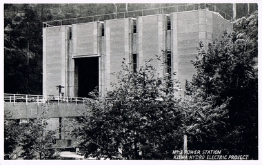
Postcard Circa 1950, No.3 Power Station Kiewa Hydro-electric Project "V.8", Circa 1950
This postcard was produced in the 1950's for the tourist trade in the Kiewa Valley and Alpine region. It encompasses the period when the State of Victoria was pressured by the ever increasing demand by industry and its population for electricity supplies. Hydro electricity was seen as an untapped natural resource to quench this demand. The Victorian Alps and the rivers flowing into its valleys was ideal for the construction of the Kiewa Hydro Electricity Scheme. The late 1940's saw the development of this scheme and the changing of sections of alpine landscape is covered by this and other postcards/pictures (tourists, construction workers, and established rural populations). This period in time was before the established wildlife and forest/nature groups became political activist who changed legislative acts to protect the environment.This rural region (Kiewa Valley/alpine plains) was at most only significant to a smaller group of winter sports, summer hikers/horse riders and rural farmers/graziers. The numbers of tourists and the increase in the local resident population was boosted by the construction of the Hydro Electricity Scheme. This influx to the regional population resulted in a corresponding diversity in services and brought about an environment that responded to a growing level of tourists and thereby permitting this industry to grow more rapidly than it would have naturally. This postcard details an attraction to the "cleaner" method of providing electricity. This postcard was purchased in 1950 by a surveyor at Landford's Gap.This black and white photograph from a Valentine's postcard is from a V2 Argus photograph postcard. It is on a 200g/m paper density photo side gloss. See 0480 (A) - (K) for other photos of similar postcards."No.3 POWER STATION KIEWA HYDRO ELECTRIC PROJECT" "V8"kiewa valley tourism, victorian alps, alternate energy supplies, alpine population growth, secv -
 Warrnambool and District Historical Society Inc.
Household, Jellie Souvenir Glass
souvenir glass was produced to commemorate the 1841 arrival in Australia from Ireland of James and Margaret Jellie . They were early settlers in the Warrnambool district, settling first at Port Fairy and then acquiring property along the Merri River in the Warrnambool area. Their children and families were prominent in the 19th and 20th centuries in the Warrnambool district as pastoralists, particularly in the Grasmere area. One son, James had an auctioneering firm in Warrnambool in the late 19th century and two of James’ and Margaret’s granddaughters, Mary and Dorcas. were well-known as teachers at the Warrnambool State School in the 20th century. This glass is of interest as a memento of the Jellie families who have been so prominent in the history of Warrnambool and district.This is a glass tumbler with a rounded base and a rounded body with a gilt rim around the top of the glass. An image of a ship and gold lettering have been impressed on both sides of the glass. ‘James & Margaret Jellie 1841-1991 150th Anniversary’ ‘To commemorate the arrival of James & Margaret Jellie and their children on the Thomas Arbuthnot at Hobson’s Bay, Port Phillip District of New South Wales on 2 October 1841 and their journey to Port Fairy in early 1842’ jellie families, warrnambool, history of warrnambool -
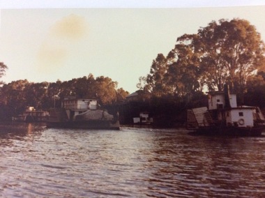 Port of Echuca
One colour photograph and one colour negative, 03/04/1984
These paddle steamers were accompanying the P.S Adelaide back to the Echuca Wharf after being re-launched on 03/04/1984. The P.S Adelaide had been displayed in the Hopwood Gardens since 1960, and the City of Echuca Mande a decision to launch the paddle steamer back into the river to be used as a working tourist attraction. This photograph relates to P000059.3, P000060.3, P000061.3, P000062.2, P000063.3, P000071.This photograph is significant as it shows the state of the Echuca Wharf in 1984. It also shows the state of the P.S Adealide after sitting idle for so many years. In 1984, the Tourism Industry was still developing in the Echuca region.Colour photograph and negative showing the P.S Adelaide heading upstream towards the Echuca Wharf, after being re-launched on 03/04/1984. The P.S Pevensey, the P.S Emmylou and P.S Etona can also be seen.On boat Pevensy, is obscured.p.s adelaide, hopwood gardens, p.s emmylou, echuca wharf -
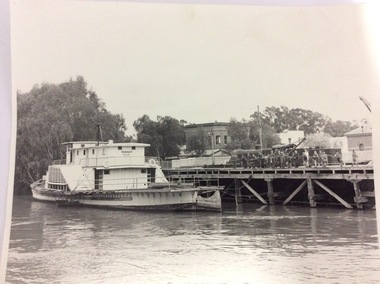 Port of Echuca
Black and white photograph, 1980? A note has been added by C.J (Claire Jackson) saying that the photo was taken about 1973-74
The photograph shows the state of the Echuca wharf in 1973 or 1974. The P.S Pevensey looks like it has just received a fresh coat of paint. There is also a train parked on the wharf behind the school students. The river also appears to be quite high. This photograph shows the state of the wharf in the early 1970's. It shows the fence between the wharf and Murray Esplande was relatively new. The tourism industry was very new to Echuca in the 1970's but the P.S Pevensey looks ready to take Tourists cruising on the Murray River. It also shows schools were using the port as a valuable resource for teaching History.A black and white photograph of the P.S Pevensey tied up to the Echuca Wharf. There is a group of school children leaning over the wire fence at the edge of the wharf. There is also one teacher supervising the children. The Steam Packet Inn and the Customs House can be seen in the background.Pevensey; Melbourne can be seen clearly written on the paddle steamer. On the back of the photograph is written "This photograph is with the compliments of the Ministry of Tourism, Government of Victoria. Please acknowledge photo; Michael Cheshire. There is also a purple Port of Echuca stamp on the back of the photograph.echuca wharf, p. s pevensey, ministry of tourism, cheshire, michael -
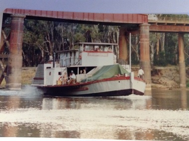 Port of Echuca
Photograph - Coloured, March 1984
This photograph was taken in February 1984 on the occasion of Cossen's visit to Echuca. P.S Pevensey with the name Philadelphia written across the wheelhouse can be seen steaming upstream under the bridge. This is significant because the P.S Pevensey played the role of the P. S Philadelphia in the movie "All The Rivers Run" which was filmed in Echuca in late 1982 and a sequel was filmed in Echuca early in 1989. Councillor Bob Snow can also be seen on the side deck. This is significant as the Cossen's visit to Echuca may have warranted this sort of attention The photograph also shows the state of the Echuca Moama bridge in the early 1980's.This photograph is significant because it shows the P.S. Pevensey showing the name P.S Philadelphia. The P.S Pevensey was used as the P.S Philadelphia in the TV Series "All The Rivers Run" based on the novel written by Nancy Cato. The TV series was filmed in Echuca in 1982. The TV series was a huge success and still draws tourists to the Port of Echuca. The fact that the P.S Pevensey was showing the Philadelphia name in 1984 is a bit of a mystery, but it has been known that she was dressed up again as the P.S Philadelphia sometimes for special occasions. The Cossen's visit to Echuca might have been such an occasion. It is also a good picture of the pylons under the Echuca Moama bridge and the actual bridge itself. The P.S Pevensey travelling upstream under the Echuca Moama bridge. There is a group of people on the lower side deck. People can also be seen in the wheelhouse and there is a man standing on the back deck as well as one standing next to the wheelhouse. The name Philadelphia can be seen written across the front of the wheelhouse. The river is low and shows the waterline at the Moama Beach. Four bridge pylons can be seen as well as the bridge itself.greenspot photography, p.s pevensey, murray river, echuca, la grue, bill, cossen's visit to echuca., all the rivers run, p. s philadelphia, echuca moama bridge, cossen family, cato, nancy -
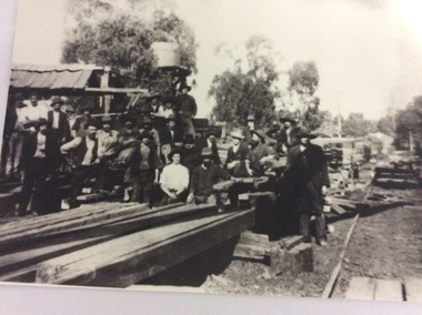 Port of Echuca
Black and white photograph
Macintosh's sawmill was on the banks of the Murray River in Echuca east where the Banyule State forest is now located. A tramway ran out to it from the main rail line near the iron bridge. Macintoshes Sawmill was one of the largest in the area. (Ref. Clare Jackson. )Macintoshes sawmill was set up by James Macintosh in 1868 in Echuca East. His sawmill prospered and in 1878 was "equal to five normal sawmills" (Ref; Coulson, Helen, "Echuca Moama On the Murray." P.158) He also owned 2 paddle steamers and 8 barges. The Macintosh Family contributed substantially to the development of Echuca East, but by 1901 the Family was in severe debt and were forced to sell the sawmill to the Nicholas Family.A black and white photograph of a large group of men outside a sawmill, reputed to be Macintoshes Sawmill in Echuca East.On the back of the photograph written in pencil are the words "Believed to be workmen at McIntosh's mill (Charlie Dowell says)macintosh's sawmill, sawmill industry, echuca east, banyule state forest, macintosh james, dowell, charlie, logging industry, jackson, clare -
 Eltham District Historical Society Inc
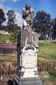
Negative - Photograph, Harry Gilham, Grave of Alfred and Margaret Armstrong, Eltham Cemetery, Victoria, Sep 2009
Alfred Patrick Armstrong was born in England in 1825 and was employed under the renowned Isambard Kingdom Brunel as a civil engineer during the construction of the Great Western Railway and the South Wales Railway. He came to Melbourne in 1852 and purchased property in Eltham. He became a mining surveyor and was Inspector of Mines and the Mining Registrar for the St Andrews Division of the Castlemaine Mining District. In 1855, he chaired a meeting calling for a bridge to be erected across the Yarra River between Eltham and Temple Stow. He was registered as an innkeeper in 1858, was a recognised collector of the £110 raised for the building of the first building of State School No. 209 (Eltham Primary) and was a Trustee for the Church of England site on the Eltham Cemetery Trust in 1860. He was elected to the Eltham District Road Board (forerunner of Eltham Shire Council) from 1867 to 1871 and then served as an Eltham Shire Councillor from 1871 to 1878 (including Shire President in 1873). Margaret Armstrong to whom he was married in 1854 at St Pauls Church, Melbourne, died on the 27th March 1887. Alfred died in 1893, having been in ill health for some time, and is buried in Eltham Cemetery with his wife Margaret. The monument features a tall pillar capped with a draped urn: a symbol of death. In Loving Memory of Alfred Armstrong Died May 27tth 1893 Aged 68 years Also of his wife Margaret Died March 27th 1887 Aged 63 years This burial site is of special interest as the monument has the tallest pillar-a vase-a draped cloth top (unfulfilled life) and additional panels of names around the sides and the base, which include: Ada Gertrude Armstrong, beloved daughter of Alfred & Margaret Armstrong, died May 30th 1878, aged 21 years Mary Armstrong, beloved mother to Alfred Armstrong, died April 10th, 1886 aged 82 years Arthur Vivian Harrison, died 4th Nov. 1899, aged 8 years Arthur Reynolds Stockwood Armstrong, son of Alfred Armstrong, died 4th Nov. 1908, aged 43 years Laura Augusta Harrison nee Armstrong, died 26th July 1921, aged 64 yearsRoll of 35mm colour negative film, 6 stripsKodak GC 400-9eltham cemetery, gravestones, alfred armstrong, margaret armstrong, ada gertrude armstrong, arthur reynolds stockwood armstrong, arthur vivian harrison, laura augusta harrison (nee armstrong), mary armstrong -
 Eltham District Historical Society Inc
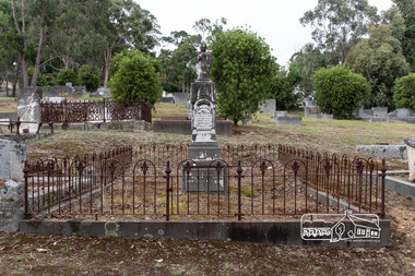
Photograph, Peter Pidgeon, Grave of Alfred and Margaret Armstrong, Eltham Cemetery, Victoria, 5 April 2021
Alfred Patrick Armstrong was born in England in 1825 and was employed under the renowned Isambard Kingdom Brunel as a civil engineer during the construction of the Great Western Railway and the South Wales Railway. He came to Melbourne in 1852 and purchased property in Eltham. He became a mining surveyor and was Inspector of Mines and the Mining Registrar for the St Andrews Division of the Castlemaine Mining District. In 1855, he chaired a meeting calling for a bridge to be erected across the Yarra River between Eltham and Temple Stow. He was registered as an innkeeper in 1858, was a recognised collector of the £110 raised for the building of the first building of State School No. 209 (Eltham Primary) and was a Trustee for the Church of England site on the Eltham Cemetery Trust in 1860. He was elected to the Eltham District Road Board (forerunner of Eltham Shire Council) from 1867 to 1871 and then served as an Eltham Shire Councillor from 1871 to 1878 (including Shire President in 1873). Margaret Armstrong to whom he was married in 1854 at St Pauls Church, Melbourne, died on the 27th March 1887. Alfred died in 1893, having been in ill health for some time, and is buried in Eltham Cemetery with his wife Margaret. The monument features a tall pillar capped with a draped urn: a symbol of death. In Loving Memory of Alfred Armstrong Died May 27tth 1893 Aged 68 years Also of his wife Margaret Died March 27th 1887 Aged 63 years This burial site is of special interest as the monument has the tallest pillar-a vase-a draped cloth top (unfulfilled life) and additional panels of names around the sides and the base, which include: Ada Gertrude Armstrong, beloved daughter of Alfred & Margaret Armstrong, died May 30th 1878, aged 21 years Mary Armstrong, beloved mother to Alfred Armstrong, died April 10th, 1886 aged 82 years Arthur Vivian Harrison, died 4th Nov. 1899, aged 8 years Arthur Reynolds Stockwood Armstrong, son of Alfred Armstrong, died 4th Nov. 1908, aged 43 years Laura Augusta Harrison nee Armstrong, died 26th July 1921, aged 64 yearsBorn Digitaleltham cemetery, gravestones, ada gertrude armstrong, alfred armstrong, arthur reynolds stockwood armstrong, arthur vivian harrison, laura augusta harrison (nee armstrong), margaret armstrong, mary armstrong