Showing 421 items matching "behind the fence"
-
 The Beechworth Burke Museum
Photograph - Carte de Visite
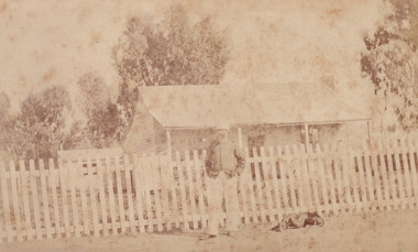
This Carte-de-viste (CdV) previously belonged to the donor's grandfather, Daniel Mullins who was a Police Officer stationed at Glenrowan soon after the Kelly gang siege. It is unclear; however, whether or not the man depicted in the photograph is Daniel Mullins or a different police officer. The Police Station at Glenrowan depicted in this CdV stood during the events of the Kelly gang's siege. Today, the siege has become an important part of Australian culture and Ned Kelly and the Kelly Gang (comprising of Ned Kelly, Dan Kelly, Steve Hart and Joe Byrne) has become ingrained in Australian history and mythology. A CdV is a sepia toned photograph mounted on card and is generally of a small size. This particular style was first patented by Andre Adolphe Eugene Disdéri (1819-1889) in 1854. In 1857, the CdV was introduced to England and after photographs of Queen Victoria, Prince Albert and their family were taken using CdV in 1860 the popularity of this method reached a peak. This photograph is part of the Burke Museum "Kelly album" which includes a significant collection of photographs and artefacts connected to Ned Kelly and the Kelly Gang. Ned Kelly and his gang have become ingrained in Australian popular culture and thus many museums, art galleries and private collections house material connected to the Kelly story which allows the events and people to be researched and interpreted. Items pertaining to the Kelly gang, including photographs like this one which depicts a police officer standing outside of the Glenrowan Police Station, are of great historical significance. Photographs like this can provide valuable information on the architecture, lifestyle and dress of colonial Australia. When studied, photographs have the ability to shed more light on the events of the Kelly gang and colonial Australia. This photograph is also of artistic significance because of the popularity of the CdV during the nineteenth century.A sepia toned photograph mounted on grey card with rounded corners. The image has been captured by an unknown photographer and depicts the outside the Glenrowan Police Station. In front of the Station stands an unidentified policeman and lying on the ground behind the policeman is a medium sized dog with dark colouring. The Police Station depicted in this photograph is a classic example of Australian country colonial architecture typically seen dating to the nineteenth century. It has the typical features of an Australian colonial 'miners' cottage' with the gable roof and a skillion at rear. A white picket fence is stands between the Station and the policeman. A small building is located at the rear of the Station which may have served as a lockup.BMM 8083kelly album, glenrowan, police, police station, photograph, ned kelly, australia, colonial australia, victoria, james bray, william e barnes, daniel mullins -
 Orbost & District Historical Society
black and white photograph, C1900
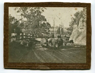
Pigs were taken to Bairnsdale by coaxing them with maize thrown from a wagonette . From Bairnsdale they were freighted to market by train. The journey to Bairnsdale took about five days . This method of transport continued until the rail line to Orbost was opened in 1916.This photograph is a pictorial record of farming practices in the early 20th century.A black / white photograph on a brown buff card showing pigs being taken to market. The photograph shows the pigs close up with men on horseback behind them. The pigs are on a gravel road with a fence on one side and and the Orbost flats can be seen in the background.on back - "Pigs being driven from Orbost to Bairnsdale. M.Gilbert, Orbost"agriculture farming-orbost pigs -
 Bendigo Military Museum
Photograph - A Section, 1st Topographic Survey Troop, Nui Dat, Vietnam, 1969
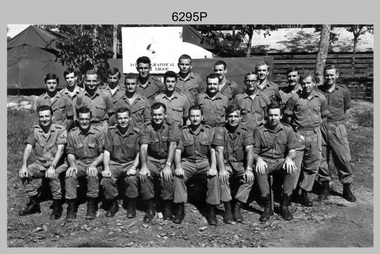
This is a photograph of A Section, 1st Topographic Survey Troop taken at Nui Dat, Vietnam in 1969. A nominal roll of personnel and their trade as of the 30th of September 1969, accompanies this photo. Their trades in this photo were as follows - Surveyors Topographic: WO1 Darby Munro, SGT Paddy Strunks, SGT Graeme Birrell, CPL Brian Knight, CPL Colin Laybutt, SPR Roderick Gilbert and SPR Rodney Offer. Draughtsmen Topographic: SGT Terrance Linz, CPL Robert Kay, SPR Peter Aukstinaitis, SPR Lloyd Patterson and SPR Ian Wark. Photographer Cartographic: CPL George Graham. Clerk Admin: CPL Oreste Biziak. Helioworker: CPL Geoffrey White, SPR Lance Percey. Cook AACC: PTE R. Johnston. The first Royal Australian Survey Corps troops arrived in South Vietnam on the 10th of June 1966. This was a detachment from 1st Topographic Survey Troop, which was to give cartographic support to the Australian Task Force. Their main tasks were to establish a Theatre Grid, map compilation and map revision. Engineer Survey Support in the camp and to the civil community and give assistance to the Cordon Search Missions by producing large scale plots from aerial photos with every house and fence etc plotted and then reproduce these by silk screening usually, within a 24-hour period. This support concluded with the withdrawal of Australian troops from Vietnam in 1972. For more information on the career of A Section’s OC MAJ Peter Constantine AM, refer to item 6159P or 6092P. He was the CO of the Army Survey Regiment from 1975 to 1976 and CO of the School of Military Survey (SMS) from 1976 to his retirement in January 1982. His memoirs of active duty in Vietnam ‘Surveyor - Printer Behind the Lines’ was published in 2022. 2IC CAPT Frank Thorogood SB St J’s career culminated at the rank of LTCOL as the CO Army Survey Regiment from 1980 to 1981. More information on the A Section, 1st Topographic Survey Troop and the Army Survey Regiment’s supporting role is provided in pages 89 to 94 of Valerie Lovejoy’s book 'Mapmakers of Fortuna – A history of the Army Survey Regiment’ ISBN: 0-646-42120-4.This is a photograph of A Section, 1st Topographic Survey Troop taken at Nui Dat, Vietnam in 1969. The black and white photograph was printed on photographic paper and is part of the Army Survey Regiment’s Collection. The photograph was scanned at 300 dpi. .1) - Photo, black & white, 1969. Back row L to R: SPR Lance Percey, SPR Bruce Grisdale, SPR Rodney Offer, SPR Roderick Gilbert, CPL Geoffrey White, PTE R. Johnston, CPL Colin Laybutt, SPR Lloyd Patterson. Centre row L to R: SPR Peter Aukstinaitis, SPR Ian Hanna, SPR Ian Wark, CPL Robert Kay, CPL George Graham, CPL Oreste Biziak, CPL Brian Knight. Front row L to R: SGT Terrance Linz, SSGT Gordon Haswell, 2IC CAPT Frank Thorogood SB St J, OC MAJ Peter Constantine AM, WO1 Darby Munro, SGT Paddy Strunks, SGT Graeme Birrell.An A4 nominal roll of personnel and their trade accompanies the photo, as of the 30th of September 1969. A torn paper identifies the personnel in the photo. Annotated on back of photo – ‘Unit Photo – 1 Topo Svy Tp 30 Sept 69’royal australian survey corps, rasvy, army survey regiment, army svy regt, fortuna, asr -
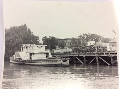
 Port of Echuca
Colour Photograph, Aug 1980
The P. S. Adelaide was positioned in the Hopwood Gardens, Echuca as a static display whilst it was waiting to be fully repairedColour photograph of back port side of the P. S. Adelaide being restored on the western side of the Hopwood Garedens, Echuca, with orange fence around it and the side of a green wooden building at its right. The park sound shell is partially visible behind the boat to the right.On reserve in pen : Adelaide in Hopwood Gardens. In red pink : Print made by Kodak M. It's Kodak for color. Aug.80. Kodakp. s. adelaide, hopwood gardens, echuca, p. s. adelaide restoration -
 Port of Echuca
Black and white photograph, 1980? A note has been added by C.J (Claire Jackson) saying that the photo was taken about 1973-74
The photograph shows the state of the Echuca wharf in 1973 or 1974. The P.S Pevensey looks like it has just received a fresh coat of paint. There is also a train parked on the wharf behind the school students. The river also appears to be quite high. This photograph shows the state of the wharf in the early 1970's. It shows the fence between the wharf and Murray Esplande was relatively new. The tourism industry was very new to Echuca in the 1970's but the P.S Pevensey looks ready to take Tourists cruising on the Murray River. It also shows schools were using the port as a valuable resource for teaching History.A black and white photograph of the P.S Pevensey tied up to the Echuca Wharf. There is a group of school children leaning over the wire fence at the edge of the wharf. There is also one teacher supervising the children. The Steam Packet Inn and the Customs House can be seen in the background.Pevensey; Melbourne can be seen clearly written on the paddle steamer. On the back of the photograph is written "This photograph is with the compliments of the Ministry of Tourism, Government of Victoria. Please acknowledge photo; Michael Cheshire. There is also a purple Port of Echuca stamp on the back of the photograph.echuca wharf, p. s pevensey, ministry of tourism, cheshire, michael -
 Port of Echuca
Colour photograph, Approx 1982
... on the Murray esplanade, Port of Echuca. Picket fence and locomotive... on the Murray esplanade, Port of Echuca. Picket fence and locomotive ...Undergrounding of the power lines took place in September 1982. Relates to "before" shots P000159, P000161, P000163 and "after" shots P000160, P000162, P000164. Interview with Helen Coulson, 27.09.1984The power lines were put under ground for the filming of "All the Rivers Run" which began in October 1982. The Port area was returned to look like it would have been in the 1870s. The roads were covered in gravel, signage was removed in an endeavour to create the appropriate era.Colour photograph featuring power poles and power lines on the Murray esplanade, Port of Echuca. Picket fence and locomotive stand behind the pole. View from across the road looking east.On the reverse:This paper manufactured by Kodakport of echuca - power lines, power lines, coulson, helen -
 Eltham District Historical Society Inc
Film - Video (VHS), Jenni Mitchell, Demolition of the Shire of Eltham Offices, 1996
Poor video quality (noise and interference), edited raw footage with music and some commentary by Merv Hanna. A video documenting the demolition of the Shire of Eltham offices at 895 Main Road Eltham under the direction of the Commissioners appointed for the new Shire of Nillumbik and some of the communities activities surrounding the event. The building was demolished exactly 25 years after the southern wing housing Engineering and Planning on the upper level and the Eltham Library on the ground level was opened in celebration of the Shire of Eltham's centenary. Video has lots of distortion and noise, and sections of clips dubbed over. Immediate initial footage of Jenni Mitchell talking about asbestos claims in the Shire Offices (Sigmund Jorgensen standing behind her) advising Council did a review of the building several years previously and had been cleared of health problems. Cuts to group of people standing outside front door of offices but possibly voice dub over not related ? Then the date 27 Jul 1996 on a scene flashes on screen immediately followed by an edited clip intro of title and credits with classical music track. It then opens with Jenni Mitchell driving to the Shire Offices on Saturday 27 July 1996 at 11.00am. Footage of Main Road past Pitt Street, Alistair Knox Park then entering Shire Office driveway which is fenced off and contractor signs hanging up. Scenes at rear of building showing some internal demolition has commenced. View of the Administration wing. More clips of road driving, Alistair Knox Park, Eltham Library and visitor car park for Shire Offices. Cuts to a group of people standing in access to visitor carpark with new Eltham Library in background, one being immediate former Shire of Eltham President, John Graves. Scenes of people looking through chain link fence and security guard checking front door. John Graves being filmed that someone informed him the Shire was offering the building to the Community Health Centre for $2.3 million and that if they had been offered a price of $1.1 for what it apparently was sold for they would have snapped it up. View of truck loaded with brick rubble literally struggling to ascend the hill of Library Place to exit into Main Road. Cuts to a scene looking at Eltham War memorial Hall through the Memorial Gate, then the Shillinglaw trees and large banner sign ‘Delta Demolitions’ hanging on office façade. Views of front door, old library and bluestone wall. Scene (31 Jul 1996) filmed at night of several white crosses with “RIP Community” and “RIP Democracy”. Scene (1 August 1996) again driving along Main Road towards the Shire Offices then scenes of the offices showing substantially more demolition to exterior, groups of people standing on footpath outside watching, Delta heavy demolition machines, woman holding sign “Democracy where have you gone …”, the odd person in full protection gear and breathing apparatus hand carrying materials out to place on rubbish pile in front of people standing on footpath watching (with no protection) and then stamping on it to break it creating dust, security person in hard hat (no other protection) wandering around, many groups standing around watching, news film crew, person standing on roadside edge holding signs facing traffic stating “Pirate Planning” and “ Grant us your ears” also sign on back of parked car “Elthams High Jacks”, another sign “Community Democracy”, views of crosses in Main Road median strip “RIP Community”, groups of people on footpaths and reporters conducting interviews, footage of unknown person standing with Jenni Mitchell and Sigmund Jorgensen advising people have the right to protest, Jenni Mitchell urging people to ask questions of local MP and Council and Sigmund Jorgensen referring to the three historic Shillinglaw trees with demolition machinery operating in background, Jenni Mitchell and others installing more crosses in median strip; demolition machines operating inside and outside the building, more views of onlookers including Sigmund Jorgensen then Police approaching on footpath, workers and machinery continuing to operate, views of the old library being demolished, the former Community Services department, security personnel. Scene (2 August 1996) more heavy demolition machinery in operation smashing building up, people standing around southern wing watching, view overlooking Eltham Library of train pulling in to Eltham station. Scene (7 August 1996) more heavy demolition and people wandering around with only hard hat protection, no dust protection, comments from one operator dumping a bin of material stating “wait till there’s a Hungry Jack’s here, you’ll be laughing, fuel, videos, hamburgers. You’ll be up with the rest of the world soon, you’ll have electricity and everything here, ha ha ha ha”, more heavy machinery demolition and breaking up of materials, view of Hitachi train going by and Administration wing, view inside the front door opening of the staircase leading to upper level, person walking around operating heavy machinery with a hose spraying rubble (no protective gear other than hard hat interspersed with edit cuts of meeting of Commissioners and independent observers on panel as well as members of the community in public gallery. Nillumbik Shire CEO Barry Rochford addressing the meeting., Chief Commissioner Don Cordell directly addressing Jenni Mitchell with respect to permission to take photographs, Barry Rochford continues to address the question asked of Council about the valuation of the former Shire of Eltham Office building/site, public gallery calling out asking why was building demolished, what was the urgency. Scene (14 August 1996) views of southern wing, previous single demolition operator again mocking people filming, operators working in and around building, Shillinglaw trees and largely demolished front, heavy demolition equipment at work, piles of building rubble, hose spraying water over rubble, large trucks arriving for rubble removal and loading of truck. Scene (21 August) more of the same, building virtually down, Shillinglaw trees standing tall and alone, water spraying on rubble and wattle in bloom. Cuts to Council meeting with public onlookers. Barry Rochford walks out, Wayne Phillips addresses meeting explaining one or two people shouting, members of the community challenging Council (Commissioners) about why due process appear to have been subverted. Former Shire President Robert Marshall in public audience, cuts back to Shire office carpark entrance site and sign hung on fence in front of library “Think Again!” and people standing around observing awaiting a protest demonstration erecting a large sign on stilts stating “Shell No!”, people singing a revised version of God Save the Queen (God Save Us All), Sigmund Jorgensen in attendance, Jenni Mitchell, Sigmund Jorgenson and others address the protest crowd, followed by people mingling, music being played then people standing around the cleared site circumference all with arms linked (video very broken up with noise) then chants “Save the Gateway” and “No Shell for Eltham” and more music and singing “Put up a parking lot”. The crowd then proceeds to walk along the footpath of Main Road. Scene (15 Sep 1996) meeting at Montsalvat in Great Hall addressed by Sigmund Jorgensen discussing a recently published list of the Commissioner’s to senior Council Officers of banned Nillumbik people, others encouraging people to view proposed plans for the site and lodge objections. Specific issues regarding asbestos claims are also addressed. Harry Gilham addresses the meeting on the subject of the Eltham War Memorial and Memorial Gardens and how Council believe a roundabout in the vicinity is of greater importance. Views of various artworks on display (for auction) and music performance in the Barn Gallery. Meeting addressed by Sigmund Jorgensen discussing an appeal against Council granting a permit to Dallas Howgate to develop the site and that the Minister has called the matter in to be decided by the governing council. This is followed by an auction of paintings.Hi-Tech Ultra High Grade Video Cassette E-180 VHS dubbing of (poor quality) edited raw footage with some music from Star Wars and commentary by Merv Hannan Converted to MP4 file format 0:30:26, 2.6GBOn label " Merv's Demolition tape No. 2 Copy"video recording, 895 main road, alistair knox park, artworks, auction, barn gallery, barry rochford, community health centre, dallas howgate, delta demolitions, demolition, don cordell, eltham, eltham library, eltham shire office, eltham war memorial, eltham war memorial gate, eltham war memorial hall, great hall, harry gilham, jenni mitchell, john graves, library place, main road, memorial gardens, mervyn hannan, montsalvat, pitt street, protest, robert marshall, roundabout, shell oil, shillinglaw trees, sigmund jorgensen, sign, wayne phillips -
 Shepparton RSL Sub Branch
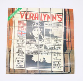
Case, Vinyl Record, Hits of the War Years, 1985
Vera Lynn was a popular artist during the Second World War, known for her wholesome and romantic songs. This record was released on the 40th anniversary of the end of the Second World War and contains twenty songs that were popular during the period, especially with serving troops. Vera Lynn was supposedly fondly referred to as the "Forces' Sweetheart." The record contains the following songs: SIDE ONE 1. (There'll be Bluebirds over) The White Cliffs of Dover 2. Harbour Lights 3. As Time Goes By 4. Beautiful Isle of Somewhere 5. Auf Wiederseh'n Sweetheart 6. Faraway Places 7. Little Sir Echo 8. Mexican Rose 9. A Nightingale Sang In Berkeley Square 10. Jealousy SIDE TWO 1. It's a Lovely Day To-morrow 2. The Bells of St. Mary's 3. A Little Rain Must Fall 4. The Anniversary Waltz 5. Yours 6. When I Grow Too Old To Dream 7. It's A Sin to Tell A Lie 8. When The Lights Go On Again 9. Drifting And Dreaming 10. We'll Meet AgainThough not rare, as a mass produced product, this record is representative of the music that was well-known during the 1940s both on the home front and by serving troops. Its release as an anniversary edition speaks to the enduring memory of the period and for some community members who lived through the Second World War, has strong social significance and ability to recall memories of the wartime period. Glossy square-shaped card sleeve printed in colour with combination of text and black and white photographs arranged as though a newspaper page. From top left corner: green stripe, red album title, union jack, photograph of a young servicewoman, photograph of the Cliffs of Dover, photograph of St Mary's and various song titles in various serif fonts. Newspaper-style page set behind metal square fencing upon brick fence, simulating a newspaper being sold. Reverse features pastel-toned photograph of Vera Lynn, with smaller collage-style image of the newspaper-style text on front, below which are song titles for Side One and Side Two in a numbered list. vera lynn, music, wartime, second world war, world war ii, world war 2, musicians, anniversary -
 Wycheproof & District Historical Society Inc.
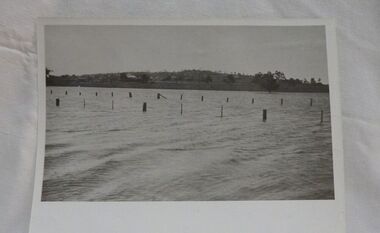
Photograph, Mr Ernie Taylor, Cooroopajerrup Creek 1923, 1923 (exact)
The semi-mythical stream, the Cooroopajerrup Creek. Before there were any channel banks and formed roads, this creek shared the Avoca flood waters with the Tyrrell Creek. In more recent times the Wycheproof channel prevented the major floods of 1956 and 1973 from following the old river course. Also there is said to have been some shifting of the sand-hills at Teddywaddy which have blocked much of the old Cooroopajerrup flow. Little is known of earlier records, but The Mount Wycheproof Ensign records flooding of the creek in 1909. 2011 saw the Cooroopajerrup flow again after 88 years. This 2011 photo was taken at about the same position as the 1923 photo. The modern steel roadway fence is submerged. see-Photograph-Record No 001997.Copy of a B&W photograph of the Cooroopajerrup-Creek in flood-1923. To the north is Mount-Wycheproof, with the hospital barely visible behind the trees just left of centre, and a few scattered dwellings. The nearer railway-fence follows the road leading to the current saleyards.The outer fence has been replaced with a modern steel fence.None1923, cooroopajerrup creek, flood, mount wycheproof -
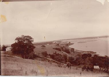 Phillip Island and District Historical Society Inc.
Photograph, Early 1900's
Donated by Jessie Smith (nee Small)Photograph of two horses grazing on hillside at Fiddlers Green, Griffiths Point (now San Remo) foreshore of Westernport. White fences dividing paddocks. School house on left behind trees and shed on right of photo. Houses and sea in background.horses grazing, phillip island, san remo, jessie smith, fiddlers green -
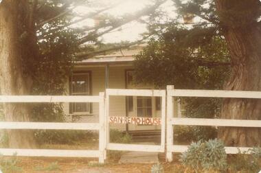 Phillip Island and District Historical Society Inc.
Photograph, 1880's
San Remo house built by Charles Grayden 1880? Possibly Miss Elms' home.Coloured photograph of front of house behind two Cypress Pines - post and rail fence across foreground.San Remo house in red on gatelocal history, photography, photographs, slides, film, san remo, local area development by europeans, housing, coloured photograph, commercial development san remo, dwellings -
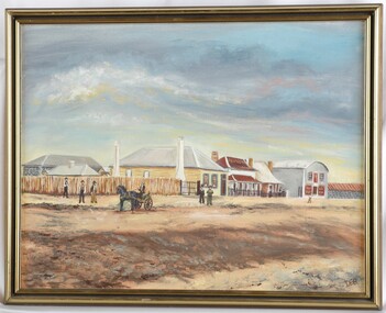 Glenelg Shire Council Cultural Collection
Painting, DEB, Percy Street, n.d
CEMA Art Collection Previously located in History HouseThe painting depicts a street scene with several buildings and people. The foreground represents a road and is depicted in shades of brown and yellow. Several men stand on the edge of the road and one sits in a horse and buggy. Behind the men are several buildings with wooden fences. The building in the centre of the work is yellow with a white roof and two white chimneys. The top half of the work is a predominately blue sky with lines of yellow, pink and white. The work has a gold and black frame and exposed canvas.Front: DEB Back: (No inscriptions) -
 Phillip Island and District Historical Society Inc.
Photograph, Bryant West, 1959
One of a collection of over 400 photographs in an album commenced in 1960 and presented to the Phillip Island & Westernport Historical Society by the Shire of Phillip IslandPhotograph of Ventnor Reserve looking north along the wire netting fence fronting Ventnor Road and showing ornamental trees with young Manna Gums behind.Notice in foreground...Planted by Phillip Island Tree Planters Association assisted by Phillip Island School Children.local history, photography, photographs, ventnor reserve, manna gums, john jenner, bryant west -
 Glenelg Shire Council Cultural Collection
Photograph - Photograph - homestead, 1920, 1920
Photographs taken by Esther Winifred Hall (nee Smallpage) - great grand-daughter of Stephen George Henty. Taken in 1934 Centenary Celebrations in Portland.Black and white photograph showing house with wide verandah of three visible sides, behind light-coloured post and wire fence with a metal gate.Front: (no inscriptions) Back: Homestead 1920. Now all creepers and trees.esther winifred hall, photography, henty, portland centenary, 1934 -
 Glenelg Shire Council Cultural Collection
Photograph - Photograph - Homestead, Side View, Esther Winifred Hill (Nee Smallpage), 1920
Photographs taken by Esther Winifred Hall (nee Smallpage) - great grand-daughter of Stephen George Henty. Taken in 1934 Centenary Celebrations in Portland.Black and white photograph of house with wide verandah, water tank (on left), behind light-coloured pole and wire fence with metal and wire gate. Donated by Ms. Mary Robinson, acting on behalf of Mrs. W.G. Hutchinson "Tellong", Blackwood River Drive, Balingup, W.A. 6253Front: (no inscriptions) Back: Homestead side view -
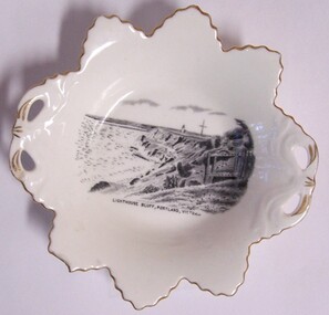 Glenelg Shire Council Cultural Collection
Souvenir - Souvenir Butter Dish - Portland Lighthouse, 1930s
Owned by James and Ada Brimblecombe, Heywood. Later owned by Merle Lewis, Mt. Gambier. R.H. Plant founded Tuscan Fine China in 1878 in Staffordshire. This area known as the Potteries, was England’s centre for the production of china. The Plant family already had a long history in producing china. Tuscan specialized in decorative fine bone china dinnerware that is very fine and light. Despite their reputation for quality, the company suffered the fate of the other potteries with lower sales and higher costs after WW2. Wedgwood purchased the company in 1967. However, Wedgwood continued producing china under the Tuscan name. However, in 1967 the new owners added the Royal prefix to the name. Despite this production ceased in 2006.Leaf-shaped butter dish of white glazed china, edged in gold. Black and white image of a lighthouse on a cliff with a tall flagpole behind it. There is a broken fence running to the edge of the cliff in the right foreground.Front: Lighthouse Bluff, Portland, Victoria (printed with image in centre of dish) Back: Tuscan China/England (stamped logo, green)souvenir of portland, portland harbour, whalers bluff, domestic item, butter dish -
 Glenelg Shire Council Cultural Collection
Photograph - Photograph - Blacknose Quarry, 29/08/1952
Port of Portland Authority ArchivesFront: 'BLACKNOSE QUARRY SITE 29 AUG 1952 SHOWING AREA STRIPPED OF OVERBURDEN' - printed in bottom frame Back: Purple PHT stampport of portland archives, blacknose quarry -
Glenelg Shire Council Cultural Collection
Negative - Negative - Portland Bird Sanctuary, 1934
Negative for a black and white photograph. Portland Bird Sanctuary. Wooden post and rail fence in water. Seagulls, cormorants, sitting on it, swans in water behindzillah maschmedt, portland bird sanctuary, wildlife -
Glenelg Shire Council Cultural Collection
Photograph - Photograph - Portland Gaol, n.d
The Gaol at Portland was in operation as early as 1852. It was reproclaimed in the Government Gazette, along with several other prisons in the colony, in October 1877. In 1892, it was proclaimed a Police Gaol, under the provisions of the Gaols Act 1890. The Police Gaol was closed by proclamation in March 1893.Black and white photo of gaol at Portland, two sides visible. High stone walls, roof of building visible behind walls. Large stone pillars either side of wooden entrance. Dilapidated wooden fence, cow grazing in foreground.Front: 'THE FIRST JAIL IN VICTORIA, PORTLAND' - white print on bottom edge of photoportland gaol, jail, incarceration, prison -
Glenelg Shire Council Cultural Collection
Photograph - Photograph - Bridgewater Hotel, Victoria, n.d
... side of door, ground floors, picket fence with gate; sand dunes... fence with gate; sand dunes behind. Photograph Photograph ...Black and white photo of the Bridgewater Hotel, front view. Double storey building, front verandah, tin roof, chimney each side of building. Three windows on first floor, window either side of door, ground floors, picket fence with gate; sand dunes behind.Back: 'BRIDGEWATER HOTEL' -printed in capitals, blue biro -
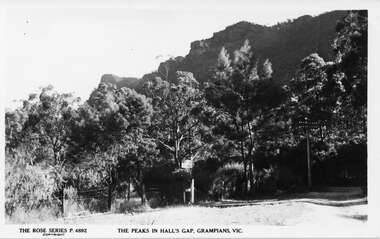 Halls Gap & Grampians Historical Society
Postcard - B/W
No. P4892 in the "Rose Series" of postcards. For information on Grampian House, refer to "Victoria's Wonderland" pp. 69-75. For information on the Wonderland Range refer to pp.41, 70, 73, 77, 84, 145-146 of "Victoria's Wonderland".Photo of the entrance to Grampian House. There is a grass are and a wire fence in the foreground. A track leads back into a bush area , there is a sign saying "Grampian House" attached to a tree. The peaks of a rocky range (the Wonderland Range) are visible behind.accommodation, guesthouses, scenery, wonderland range -
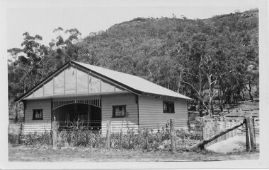 Halls Gap & Grampians Historical Society
Postcard - B/W, C 1940s
This is the Warren Street residence of the owners of the bakery, which was situated behind this building. The owners were John and Florence Warren who ran the bakery until the 1960's when it was taken over by their daughter Ida and son-in-law Robert Greer. A weatherboard house surrounded by a 'chicken wire' fence. There is a wooded hill in the background.buildings, houses -
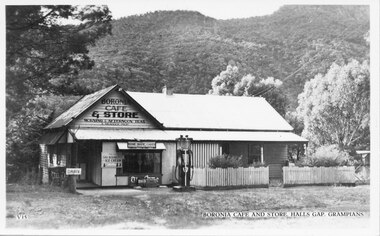 Halls Gap & Grampians Historical Society
Postcard - B/W, C 1930s
The picture is of Boronia Cafe and Store, which was situated one kilometre south of Halls Gap township.The postcard shows a building with a sign reading "Boronia Cafe & Store". The building has a picket fence at the front and a canvas awning on part of its verandah. There is a petrol pump at the front of the building and wooded hills behind.buildings, shops -
 Halls Gap & Grampians Historical Society
Postcard - Sepia, C 1930s
... . A sapling fence is behind him.... mouth. A sapling fence is behind him. Postcard Sepia ...Photo is of Augustus Knight, owner of Knight's tea-rooms. Gus was part German.Photo shows a seated man holding a pipe to his mouth. A sapling fence is behind him.people, knight -
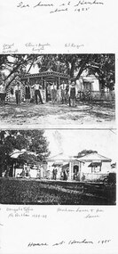 Halls Gap & Grampians Historical Society
Photograph - Photocopy, C 1925
... fence to the right. A log fence with a gap is behind the people...). There is the corner of a house and a picket fence to the right. A log fence ...The (known) people in the top photo are - boy running in background, Bert Knight; couple third & fourth from left, Ellen and Augustus Knight; 3rd from right, Gil Rogers. The bottom photo is Henham house and tea rooms and Dougal and Effie McArthur (1924 - 1929) are among the people.This is a photocopy of two photos. The first (top) image shows eight people standing in front of a building (the tea-rooms at Henham). There is the corner of a house and a picket fence to the right. A log fence with a gap is behind the people and a ninth man is running towards the gap. The second (bottom) image shows eight people standing in front of a house with a smaller building to the side (Henham house and tea-rooms).people, knight, buildings, tea rooms -
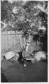
 Halls Gap & Grampians Historical Society
Photograph - Sepia, C 1921
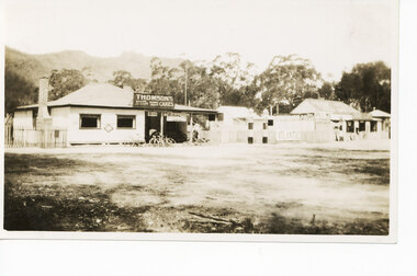
Stores in Halls Gap.The photo shows a shop (with Thomson's Cakes" on a sign on the roof) with four bicycles at the front. There is a man standing behind the bikes. To the right of the shop is a fence, with an Atlantic Petrol sign attached to it and two petrol pumps in front of it. Further to the right is another store/cafe.buildings, shops -
 Halls Gap & Grampians Historical Society
Photograph - Sepia, C 1876
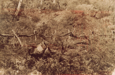
This is a photo of the fence at the side of Delley's house. The construction method is interesting; two branches crossing each other were used as uprights and branches were layed across the forks thus created at the railing. This photo is enlarged from the left hand side of Record 531.The photo shows a rough fence built from untreated branches. It runs through low scrub and some low rock can be seen in the background behind it.buildings, houses -
 Halls Gap & Grampians Historical Society
Photograph - B/W, C 1952
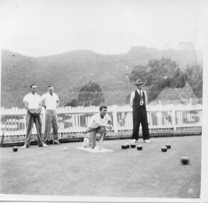
Halls Gap once boasted a fine Bowling Green, ideally situated next door to the Kookaburra Cafe. These days lawn bowling has been replaced by another bowling game, Petanque, with regular meets taking place at the club's "piste" beside the recreation centre.Three men dressed in casual clothes, two men in slacks and white shirts,another man standing to the side is dressed in dark pants and vest with a hat on. One man is kneeling after bowling. A number of bowls are on the green, behind the men is a white picket fence. The Mt.William Range is in the background.On reverse M.Mair about 1952recreation, lawn bowling -
 Halls Gap & Grampians Historical Society
Photograph - Photocopy
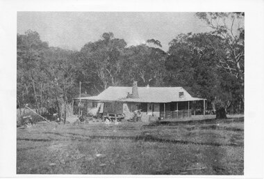
This house belonged to Walter Zumstein of the Zumsteins area. The house was burnt down in 1938. Photo was taken by Stan Parfett whose own family camped in the Zumstein area and knew Mr and Mrs Zumstein personally. c1920's This is an photocopied enlargement from a photocopied magazine article, Victoria's Heritage (see item 637)A house with veranda. A chimney (stone?) protrudes from roof at front. cleared land in foreground with old style wooden fence visible. A tank and stand situated beside house at front. Thick trees /Bush behind house.House Burnt 1938. Walter Zumstein's house. Photo by Stan Parfett. written on back.buildings, houses -
 Eltham District Historical Society Inc
Photograph, Hurstbridge shops, Heidelberg-Kinglake Road, opposite Hurstbridge Railway Station, Eltham Heritage Tour, 24 May 1992, 24/05/1992
ELTHAM HERITAGE TOUR The Society excursion on 24th May 1992 was arranged by David Bick, leader of the team carrying out the Shire's heritage study. David selected a number of sites or buildings identified in the study, some of them lesser known components of the Shire's heritage. The tour commenced at the Eltham Shire Office at 10.00 am. Travel was by private car and mini-bus with stops at about twelve locations for commentary by David.It included a short walk in Hurstbridge and lunch at Kinglake. Highlights of the tour included: - 10 am Leave from Shire Offices - 3 Important Trees - A Physical Link to Eltham's First Settlers - Toorak Mansion Gates - A Surviving Farm House - An Intact Circa 1900 Main Street - First Settlers - Gold Miners, and Timber-getters - An Early Hotel - A Pioneering Homestead - Changing Eltham Shire - 20th Century - 4 pm Afternoon Tea and Finish Tour Extract from ELTHAM CULTURAL HERITAGE TOUR (Newsletter No. 85, July 1992, by Bettina Woodburn) "Leaving the cars at Hurstbridge we walked the main street of the old village settlement, now a suburb. Near the station was a fine Edwardian house complete with palm and pines. Opposite was the Police Station, 1930-60 with a portable lock-up behind and the residence beside it. No. 794 was the Post Off1ce 3099 the-original shop-front window now has mail-boxes below. Close to the Railway entrance the butcher's shop remains unchanged, but across the road the linear shopping centre tries to keep the character of the olden times. The Fire Bell once hung on a tall gum outside No. 832. Palms in front gardens indicate the age of some of the homes, about 70 years. A corrugated iron shed still stands on the front fence line next to No. 840. Adding to the streetscape is an example of the standard timber early 20th century four veranda post suburban villa."Record of the Society's history and activities and highlighting various aspects of the Heritage Study undertaken by David Bick used to create the future heritage overlay for the Shire of Eltham and later Nillumbik Shire.Roll of 35mm colour negative film, 4 stripsKodak Gold 100 5095shire of eltham historical society, activities, heritage tour, hurstbridge, shops