Showing 439 items
matching early 1940s
-
 Eltham District Historical Society Inc
Photograph, Liz Pidgeon, Heritage Excursion; East of Eltham, 6 Sep 2014, 20 May 2017
Newsletter No. 218, September 2014 September Excursion - East of Eltham Walk In Newsletter No. 197, March 2011, there was a brief history of Crown Allotment 15 Section 5 Parish of Nillumbik (CA 15) a parcel of land of a quarter of a square mile extending from Eucalyptus Road to Reynolds Road at the eastern extremity of Eltham. From the 1940s it was known as Stokes orchard. In later years it has been subdivided for residential purposes but leaving significant areas as power line and water supply reserves and bushland reserves that are habitat for the threatened For our excursion on 6th September we intend to walk through CA 15 to a bushland reserve east of Reynolds Road. The walk will traverse the boundary between suburban Eltham and the non-urban areas to the south and east. This is a pleasant walk through residential areas and bushland. Along the way we will discuss the early and more recent history of CA 15 as well as local natural history and geology. This walk is about 3.5 km in length and will take 2 to 2.5 hours. It will start at 2pm at the corner of Eucalyptus Road, Pitt Street and Nyora Road.Born Digitaleltham east, eltham district historical society, heritage excursion, activities, nyora road, reynolds road, gum tree road reserve, diosma road, stokes orchard, eucalyptus road -
 4th/19th Prince of Wales's Light Horse Regiment Unit History Room
Transmission Assembly, Ferret Scout Car, Daimler, c 1950
The Ferret Scout Car , was developed by the British Army in the late 1940s and came into production in the 1950s. The Ferret first saw service in the British Army in 1952, and a little later in Australia. There were many series and Marks of the Ferret. In Australia two were primarily used. The Mark1, which had no turret and a crew of three, and the Mark2, with a turret and a crew of two. The Australian Army used the Ferrets as scout cars until the 1960s, they were disposed of by public auction in the early 1970s. The Ferret is a light armoured car, intended for light reconnaissance work, they are very mobile and were well suited to their role. The vehicle was designed by Daimler, as a further development on the successful Daimler Dingo of WW2. The Ferret is fully armoured and the standard model of the Ferret Mk2 was further strengthened shortly after its design and became the Mk2/3 (this is the usual model referred as the Mk2). The motor was Roll Royce B60 motor, giving the vehicle a power to weight ratio of 29.35 break horse power per tonne, the vehicle weighs 3.6 tonnes, although a combat weight would be 4.3 tonnes. It is four wheel drive, constant, and has a top speed of 93 k.p.h. (approx 50 m.p.h.). Fuel consumption is only about 34 litres per kilometer. The Ferret is 3.8 metres long by 1.9 metres wide and is 1.9 metres high, not including radio aerials. The ground clearance is .33 of a metre and the track width is 1.5 metres.Ferret Scout Car - B60 No 1 Mk 6A transmission assembly incorporating engine, fluid coupling, gear box and transfer box.Engine Number 12993 List Number 35418 Modification plate marked to Mod 3. ferret scout car, transmission -
4th/19th Prince of Wales's Light Horse Regiment Unit History Room
Transmission Assembly, Ferret Scout Car
The Ferret Scout Car Mark 2, was developed by the British Army in the late 1940s and came into production in the 1950s. The Ferret first saw service in the British Army in 1952, and a little later in Australia. There were many series and Marks of the Ferret. In Australia two were primarily used. The Mark1, which had no turret and a crew of three, and the Mark2, with a turret and a crew of two. The Australian Army used the Ferrets as scout cars until the 1960s, they were disposed of by public auction in the early 1970s. The Ferret is a light armoured car, intended for light reconnaissance work, they are very mobile and were well suited to their role. The vehicle was designed by Daimler, as a further development on the successful Daimler Dingo of WW2. The Ferret is fully armoured and the standard model of the Ferret Mk2 was further strengthened shortly after its design and became the Mk2/3 (this is the usual model referred as the Mk2). The motor was Roll Royce B60 motor, giving the vehicle a power to weight ratio of 29.35 break horse power per tonne, the vehicle weighs 3.6 tonnes, although a combat weight would be 4.3 tonnes. It is four wheel drive, constant, and has a top speed of 93 k.p.h. (approx 50 m.p.h.).Fuel consumption is only about 34 litres per kilometer. The Ferret is 3.8 metres long by 1.9 metres wide and is 1.9 metres high, not including radio aerials. The ground clearance is .33 of a metre and the track width is 1.5 metres.ferret scout car, transmission -
 Kiewa Valley Historical Society
4 Photos framed - Kiewa Hydro Electric Scheme 1940s
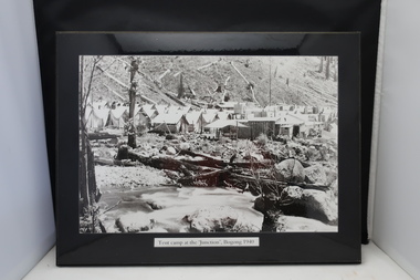
... in the early 1940s (during WW2) tell the story of fire, flood ...These 4 black and white photos are very clear and are of Bogong in the 1940s when the Kiewa Hydro electric Scheme was being constructed. Bogong was the first construction site. Bogong was a township and construction site for the Kiewa Hydro Electric Scheme built by the State Electricity Commission of Victoria. These photos in the early 1940s (during WW2) tell the story of fire, flood and living conditions with the inference of transport being horses in 1940 compared with its development in 1944.1. Tent camp at the 'Junction', Bogong 1940 2. Junction Dam September 1940: floodwaters over coffer dam 3. 'Reservoir' Camp with Bogong Stables in foreground, 1940 4. Junction Dam and Bogong village in August 1944 Each photo has string attached on the back with tape - for hangingSticker on the back of each photo: 'Framing/ Colour Magic / Shop 7, Lismore Central / Carrington Street, Lismore / Phone (02) 6621 3289'bogong township 1940, junction dam 1944, reservoir camp 1940, bogong stables 1940, tent camp at bogong -
 Kiewa Valley Historical Society
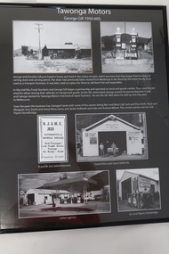
Posters - "Tawonga Remembers" x 4
The town of Tawonga is in the Kiewa Valley surrounded by farmland. It is adjacent to Mt Beauty (built in 1946), an SECV town built for the workers on the Kiewa Hydro Electric Scheme which was being constructed from 1911 to 1961. Tawonga consisted of essential amenities including a store, school, butter factory, sporting facilities, post office, hall and hotel. Activities involved sport, social get togethers eg. dances, fundraising, CWA etc.The posters are a collection of historical photos, documentation and information regarding the history of the town of Tawonga,which is the centre of a farming community in the Kiewa Valley.Poster framed with thin black plastic strip, covered, by glass. Each one has a title re "Tawonga Remembers" and includes print and phtots in black and white. Black background. 1. Tawonga SEC Depot; 2. Tawonga Service Station circa 1940s; 3. George Johnston's Taxi Service; 4. Tawonga Motors 1950-60stawonga, photos of early tawonga, kiewa valley, tawonga remembers, transport -
 Kiewa Valley Historical Society
Folder - Bogong Village in c1997
Bogong Village was constructed in the early stages of the Kiewa Hydro Electric Scheme. Employees of the SECV lived there before the town of Mt Beauty was constructed in the late 1940s. By 1997 the village was owned by Southern Hydro who didn't want a 'non-core service' and wished to sell it.The history of Bogong Village is that of a construction town that no longer has a use for its owner. However, it has an emotional significance for people in the area, especially those who worked and lived there. It is also a tourist attraction and includes the Outdoor School - Bogong Campus which was called the Bogong Outdoor Education Centre in 1992. Its history began in 1968 when the Victorian Education Department acquired the camp buildings and four houses from the SECV. Blue plastic folder with black spiral binding with 12 back-to-back pages in plastic sleeves. It includes articles relating to the future of Bogong Village c1997.bogong village sale, southern hydro c1997 -
 Kiewa Valley Historical Society
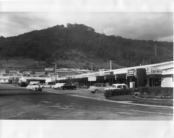
Photo - Kiewa Crescent Mt Beauty Circa 1960s
Mt Beauty was constructed by the SECV in the late 1940s. Built as a construction town for workers and their families during the construction of the Kiewa Hydro Electric Scheme. This photo shows the shops and cars in Kiewa St, Mt Beauty and the houses and Chalet in the background in the early 1960s.Large black and white photo taken from Lakeside Avenue end near the Post Office and looking towards the Chalet and Mt Beauty hill.Stamp in purple: "Please quote / No. LH1399 / when ordering / Laurie Richards / JW 1528"mt beauty township, kiewa st mt beauty, shops and cars in the 1960s mt beauty. -
 Kiewa Valley Historical Society
Dress - formal mourning
Formal mourning dress possibly worn by Mrs Vyner senior. This dress would have been made circa 1930s - 1940s. The McKendrick family came to Mt Beauty very early in the Kiewa Hydro Electric Scheme (KHES) days. Their son, Ian, worked in the Mt Beauty Post Office for 40+ years. The Vyner family also were long time employees of the SECV working on the KHES and were residents of Mt Beauty. Margaret was a nurse at the Tawonga District Hospital at the Tawonga site and the Mt Beauty site.Three quarter length black crepe dress with an 8 gored skirt and with a sash made of black crepe attached to the dress. Fitted long sleeved V neck bodice with satin applique and a pink nylon ruffle pleated around the neckline. Fitted sleeves with 2 covered buttons at the end. mourning dress, mckendrick family, vyner family -
 Kiewa Valley Historical Society
Papers - Mt Beauty Householders 1964, Mt Beauty Householders - Directory
Mt Beauty township was built in the late 1940s by the State Electricity Commission of Victoria for its workforce during the construction of the Kiewa Hydro Electric Scheme.This is a list of the early occupants of Mt Beauty township, naming the head of the household. It lists their phone numbers but not their occupations or family members.16 pages of Foolscap paper held by 2 staples in the top right hand corner. It consists of the following headings: - Name, Address, Phone No., and Sect-Allot.. The names are in alphabetical order. Commission owned houses are asterisked. All lists are as at 1st October, 1964Written in pen on top of first page "Patrol Supvr. - Info. Centre'mt beauty householders, mt beauty directory, mt beauty telephone directory, mt beauty residents 1964, mt beauty township -
 Kiewa Valley Historical Society
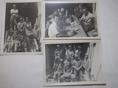
Photos - Jack Watson Collection x3
... The KHES was constructed from the late 1940s to the early... was constructed from the late 1940s to the early 1960s. Jack Watson worked ...The KHES was constructed from the late 1940s to the early 1960s. Jack Watson worked on the Kiewa Hydro Electric Scheme for 39 years. The photos show a group of men (workers) at the entrance of a tunnel.1. Jack Watson is the worker on the back right hand side with a soft Akubra type hat. 2. Jack Watson at the front on the right hand side. 3. Men not identified. When Jack retired he had been the supervisor of the patrolmen during the last 8 years.Three black and white photos of a group of men in work clothe at the entrance to a tunnel on the Kiewa Hydro Electric Scheme.jack Watson has been identified in two of the photos.jack watson, tunnel workers khes -
 Kiewa Valley Historical Society
Facit Calculator, Office Equipment
This calculator is like a modern calculator style keypad with a traditional pinwheel calculator. In operation it is similar to other Facit machines. The design from the 1930s was produced without interruption with only slight modifications until the early 1970s.This one hasn't a serial number or Model Number so date is unknown but probably the 1940s - 1950s when the SEC were constructing the Kiewa Hydro Electric Scheme.Used by the SEC Office Staff when the SECV were constructing the Kiewa Hydro Electric SchemeBox shape with grey steel top and sides on a black base. Three thin strips of stainless steel embossed with numbers on the top and clear panels beside them. Front has 3 red and 10 black knobs with arrows on the red and numbers on the black. Sides have stainless steel pedals and winders. The machine is very heavy. See on-line "mechanical calculators.wordpress.com"'Facit' on the front.calculator, facit -
 Kiewa Valley Historical Society
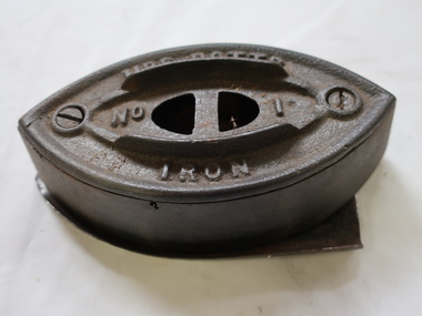
Iron - Mrs Potts No. 1
A clothes iron is used, when heated, to press clothes to remove wrinkles and creases.The early irons were heated over a stove or in a fire. Irons were used very early in time and cast-iron irons during the 18th century. Mrs. Potts invented many irons starting from an early age thus making a difference to the clothing industry. She invented clothes irons with detachable wooden handles. Her first patent was in October 1870.This iron was used in the Kiewa Valley.Vintage cast iron body invented by Mrs Mary Florence Potts 1890s to 1940s. Detachable wooden handle (not attached) was cooler than a metal handle. It is double pointed for ironing in both directions. Body is hollow the top part being held by two screws. It can be filled with a light material. The No. 1 size is for specific ironing task. compared with No. 2 or No. 3. One handle with other bases enabled some to be reheating while using one. This iron has a stand. Formerly KV88B)Mrs Potts / No. 1 / Iron"" embossed on the topmary florence potts iron, cast iron, laundry, mrs potts -
 Kiewa Valley Historical Society
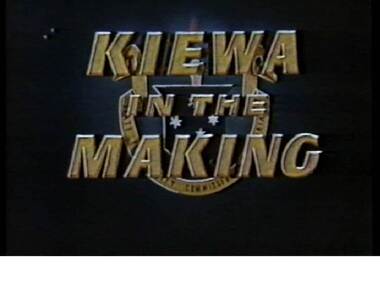
VHS Video - Kiewa, Kiewa Compile, Date compiled 25th Nov. 1998
The construction and development of the Kiewa Hydro scheme showing its construction and the people in work and play during its duration. It also shows the development of Mt Beauty and Bogong townships. The films were used as News Reels, Tourist Information and Entertainment.This item provids a snap shot in time (1990) when the Kiewa Valley was still relatively under populated and holiday houses owned by city bound workers was still relatively insignificant. As more and more holiday makers retire to a small but friendly region(Kiewa Valley and Mount Beauty) the increase in visitor numbers will affect the local rural bush scene more and more. The changes that will occur (in time) can be measured against the scenes presented in this video. The additional resources provided by the State Electricity Commission of Victoria of "alpine bush" fire control and management, together with an ongoing educational scheme for school children in learning about what constitutes the Alpine country's unique environment, are a very important offshoot, benefitting to both the communities within the Kiewa Valley and regional Victoria.This VHS tape is stored within its own plastic cover which has a front side Titled "KIEWA in the MAKING". The VHS tape is nestled within a formed inner structure which not only prevents the tape from moving to and fro but also unnecessary intrusion of foreign particles. Titled "Kiewa Compile" with 4 short films titled 1. Kiewa in the Making 2. Kiewa Capers 3. It only seems like yesterday 4. Kiewa.kiewa, hydro electricity, state electricity commission of victoria, construction towns, 1940s 1960s, mt beauty, bogong, falls creek, clover power station, mckay power station, bill sutton, news film, construction workers, early machinery -
 Eltham District Historical Society Inc
Book, St Andrews Primary School Council, St Andrews: A Village Built on Gold : the history to present day of St Andrews and District compiled by St Andrews Primary School Council, 1998
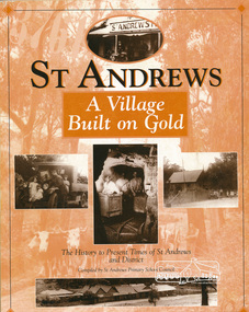
This history of the Victorian town of St. Andrews (formerly Queenstown) and its surroundings was written to celebrate the 140th anniversary of St Andrews Primary School. Describes the displacement of the Aboriginal inhabitants of the area, European settlement and the Gold Rushes and the Caledonia diggings. Discusses establishment of the school, church and cemetery and various other notable events. The school in 1998 and speculations on the future by primary school pupils. Contents: Introduction The First People Mining- What a rush! The School The Church Queenstown Cemetery The Hotels The Police Paddocks The Families Queenstown in the early twentieth century The Queenstown Bush Fire Brigade The 1st Queenstown Scout troop Queenstown, the 1940s and 1950s The Characters Odds and Sods St Andrews - The Present Times The Future St Andres Primary School in 1998This book is significant in that it documents the history of the St Andrews community from the indigenous presence through its foundation during the Victorian Gold Rush through to local bushfires and predictions of the future by local primary schools students in 1998. It remains the only significant secondary source publication written specifically on this rural community.158 p. : ill., ports ISBN 0646353756st andrews, queenstown -
 Eltham District Historical Society Inc
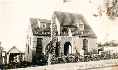
Photograph, Cooks Cottage, Arthur Street, Eltham, c.1940s, 1940s
Sepia photograph of Ernie Andrews house, Arthur Street, Eltham c.1940s (now Safeway carpark)Site: Arthur Street, Eltham Now: Part of Woolworths, formerly Safeways Car Park Was: Known as Cooks Cottage Owner: Ernie Andrews, died 1950. House was demolished early 1950s See also: 00183arthur street, eltham, cooks cottage, ernie andrews, houses -
 Emerald Museum & Nobelius Heritage Park
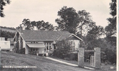
Postcard - B/W, Silver Springs Lodge, Emerald, circa 1949-50
Silver Springs Lodge, Emerald, was owned and managed in the 1940s-1950s by William and Olive Hamilton. It offered Pianola, Radio, Swimming, Tennis, Riding, Golf, Farm Produce, Home Cooking, coke fires, continuous hot water and was sewered. Weekly Tariffs were ₤4-10-0 and ₤4-15-0. Mrs Hamilton served as official photographer for Royal visits.The Lodge was an early tourist enterprise in the region, and located in a particularly admired area.B/W postcard photo issued by Valentine's, showing front gate and part profile of Silver Springs Lodge, Emerald. Caravan visible to left, and five people visible around the front door. Arch over front gate bears legend "Silver Springs Lodge".FRONT: Silver Springs Lodge, Emerald V6 REVERSE: Valentine's POST CARD A GENUINE PHOTOGRAPHsilver springs lodge, hamilton, guest houses, valentine's -
 Eltham District Historical Society Inc
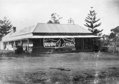
Photograph, C. Wraight's Kangaroo Ground Supply Store, c.1910
Cornelius (Con) and his wife Elizabeth ran the store and post office from about 1904. Their son Donald became involved with the store in the 1930s. A petrol bowser was added in early 1933 and a second in 1937. The Wraights ran the store till the 1940s. Elizabeth died 10 April 1952 and Cornelisu May 30, 1954.This photo forms part of a collection of photographs gathered by the Shire of Eltham for their centenary project book,"Pioneers and Painters: 100 years of the Shire of Eltham" by Alan Marshall (1971). The collection of over 500 images is held in partnership between Eltham District Historical Society and Yarra Plenty Regional Library (Eltham Library) and is now formally known as the 'The Shire of Eltham Pioneers Photograph Collection.' It is significant in being the first community sourced collection representing the places and people of the Shire's first one hundred years.Digital image (negative of original print missing)shire of eltham pioneers photograph collection, kangaroo ground, cornelius wraight, eltham-yarra glen road, general store, kangaroo ground store -
 Eltham District Historical Society Inc
Photograph, Eltham State School No. 209, Dalton Street, Eltham, c.1918
Eltham Primary School. This building is the earliest building remaining on site today. It was built in 1875 and was the second school building replacing the original 1856 building of stone walls with wooden shingles on the roof. That building needed to be replaced after the stone walls collapsed outwards. In August 1912 the school issued a requisition for remodelling of the school concerned with replacement of the existing windows with larger and wider windows to allow additional light into the school rooms and the erection of a wooden partition in the centre of the room. This work commenced in early 1914 and this photo shows the altered windows. Pre 1921 extension and skylights in roof. Only two low wooden stairs present to enter the porch. These were rebuilt by 1928. A steel mud grate was introduced 1930s/1940s and an infant shelter shed is shown on the 1945 plan. Photo most likely taken between 1914 and 1921.This photo forms part of a collection of photographs gathered by the Shire of Eltham for their centenary project book,"Pioneers and Painters: 100 years of the Shire of Eltham" by Alan Marshall (1971). The collection of over 500 images is held in partnership between Eltham District Historical Society and Yarra Plenty Regional Library (Eltham Library) and is now formally known as the 'The Shire of Eltham Pioneers Photograph Collection.' It is significant in being the first community sourced collection representing the places and people of the Shire's first one hundred years.Digital image 4 x 5 inch B&W Negsepp, shire of eltham pioneers photograph collection, eltham, dalton street, state school no. 209, eltham primary school, eltham state school, schools -
Ringwood and District Historical Society
Work on paper - Letter, Mrs Kerry Puckey (nee Jansen), early resident of Everard Road, East Ringwood, 1940s-1950s. Notes prepared by June Puckey (nee Kemp), 1940s-1950s
Mrs. Kerry Puckey, formerly Jansen, C/- Yellingbo Post Office, Yellingbo 3139, student at East Ringwood School.Notes prepared by June Puckey (nee Kemp) on early resident of Everard Road, East Ringwood. +Additional Keywords: Puckey, June / Kemp, June / Puckey, Kerry / Jansen, Kerry -
 Orbost & District Historical Society
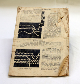
book, first half 20th century
In the early 20th century, smocking appears in women’s magazines and sewing manuals on garments, domestic textiles and children’s wear. The 1930s and 1940s were the heyday of patterns and innovative stitch development. Embroidery has always had a great appeal to women, as it needs few tools. Historically the skills were taught within the family or in primary schools. Articles to make or embroider had been available in kits since the 1850s. Fancy work, the opposite of plain sewing, enjoyed great popularity in the 19th and 20th centuries. Companies which manufactured threads often produced instruction guides and patterns. This instruction book has been well-used. A small 30pp book with no cover. It contains instructions for embroidery stitches, including smocking.book-embroidery smocking handcraft needlework -
 Flagstaff Hill Maritime Museum and Village
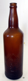
Container - Beer Bottle, Bottle Co of Victoria Pty Ltd, 1930-1940s
The subject item was produced for the Carlton and United Breweries, in Melbourne, at one time, almost all breweries in Australia had their own brand of returnable bottle or were members of bottle co-operatives that managed returnable bottles. Instead of being crushed to make new bottles, as happens in most cases today, these returnable bottles were returned to the brewery or bottle co-operative, washed, inspected for cracks and chips and returned to service. An early item giving a snapshot into social history in 1930s - 1940s AustraliaBrown glass beer bottle, 26 fluid ounce capacity, "CUB" raised motif and in small spade motif on shoulder "MBCV" (Melbourne Bottle Company of Victoria)flagstaff hill, warrnambool, flagstaff hill maritime museum, shipwreck coast, flagstaff hill maritime village, great ocean road, bottle, brown glass bottle, cub, melbourne bottle company of victoria, beer bottle 1940s, carlton united breweries