Showing 11902 items
matching geo-map
-
 National Vietnam Veterans Museum (NVVM)
Map, Relief Map of Vietnam
Detailed relief map with words XA BIN BA + XUYEN MOC titled on information heading. Map information listed on lower portion.relief map, vietnam -
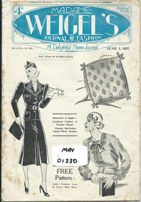 City of Moorabbin Historical Society (Operating the Box Cottage Museum)
Booklet - Madame Weigel's Journal of Fashion, A Delightful Home Journal June 1 1937, c1937
Gladys Reed was a member of the Ormond Choral Society c 1950. who performed plays and musicals the City of Moorabbin and she used these patterns to make clothes etc.for her family and the Choral Society. Madame Weigel who migrated to Melbourne in1877 with her husband Oscar; began publishing in 1878 and distributed paper patterns of the latest fashions, throughout Australia and New Zealand, She and Oscar became the first commercial manufacturers of paper patterns in Australasia, and to publish Weigel's Journal of Fashion (1880-1915) and Madame Weigel's Journal of Fashion (1915-1950). Madame Weigel had an enormous following of women who used her patterns across the generations, and across the life cycle from babies to 'matrons'. Madame Weigel died in 1940 aged 92 years. Finally, after 91 years of business and millions of patterns sold, Madame Weigel's paper pattern business closed in 1969.Gladys Reed was a member of the Ormond Choral Society c 1950. who performed plays and musicals in the City of Moorabbin and used these patterns for clothes etc for members of her family and the Choral Society. Madame Weigel was one of the most remarkable of early Australasian business women.A black and white booklet of 37 pages with advertisements, sketches, articles, photographs, knitting,crochet and tapestry instructions, dressmaking patterns and recipes. Volume LV111 pages 122 - 159 completeFront Cover ; Registered at the General Post Office Melbourne for transmission by post as a Newspaper / 4d / Published Monthly / MADAME / WEIGEL'S / JOURNAL OF FASHION / Vol LV111 No. 688 / A Delightful Home Journal / JUNE 1, 1937 / 58th YEAR OF PUBLICATION / Illustrated at Right - / Crocheted Cushion of / Unusual Design./popular Bed-Jacket. / ( Daisy Wheel Design) /Illustrated at Left - FREE Pattern ; / Lady's Costume Coat. / 34 Inches Bust Meas. Back Cover : Advertisement for Bushells Blue Label Tea / Printed and Published by Geo. Humphries for Madame Weigel Pty Ltd , Lennox and Rowena Sts., Richmond. Vic.haberdashery, cotton, lace, pillow cases, sheets, clothing, dressmaking, needlework, market gardens, dairy farms, lacework, craftwork, moorabbin shire, bentleigh, moorabbin, cheltenham,reed gladys, clark judy -
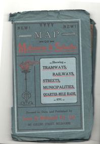 Melbourne Tram Museum
Map, Sands McDougall, Map of Melbourne and Suburbs showing Tramways, Railways, Streets, postal districts, Quarter-Mile Radii etc", c1922
Shows railways, cable and electric tram lines c1922. One of a number of maps produced by Sands McDougall of Collins St. Includes the Zoo horse tram lines. See acquisition and Research note by Duncan McAuslan. See items 2885, 6573, amd 6917 for other editions. On inside cover has current postal rates (including a war surcharge) and places worth visiting and on the rear cover, is an advertisement for Imperial ink.Yields information about Melbourne c1922 and its public transport lines. Produced by Sands and McDougall Pty Ltd of Collins St Melbourne. Folded sheet of paper 6 sections wide x 6 sections or folds deep contained within a green paper cover titled "Map of Melbourne and Suburbs showing Tramways, Railways, Streets, postal districts, Quarter-Mile Radii etc", showing both cable and electric tramways. maps, melbourne, cable trams, tramways, railways, horse trams, vr trams, sands mcdougall, zoo horse tramway, mmtb -
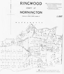 Ringwood and District Historical Society
Photograph, Parish map of Ringwood, County of Mornington - 1878
Copyright note states "Crown (State of Victoria) Copyright 1973"Written on backing sheet, "SLV Parish Map Collection Vol.23, Fol.64". -
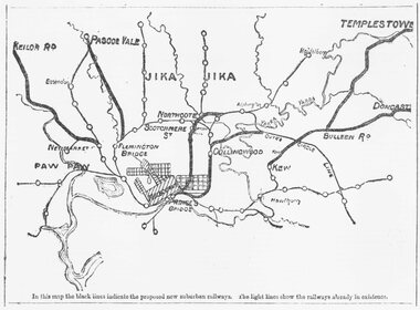 Ringwood and District Historical Society
Photograph, Map of Melbourne suburbs showing proposed new railway lines - 1890
Catalogue card reads, 'Map of Melbourne suburbs showing proposed new lines - 1890.' -
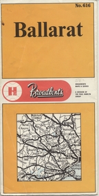 Ballarat Tramway Museum
Map, Broadbent's, "Broadbent's Map 616 Ballarat", c1960
Yields information about the extent of Ballarat in the early to mid 1960's shows the tram lines and other rail lines in the district.Printed street map titled "Broadbent's Map 1616 Ballarat" printed in colour on one side only of a folded (10) sheet. Shows the suburbs of Ballarat, tram lines, has a scale in miles, Ballarat District map and an index to streets. Also points interest and historical interest. also shows railways lines. Map used as the base for the tram line map in the display area in the depot. Large Res scan made 28/1/2011."50c" in pencil on front cover.trams, tramways, map, ballarat, broadbent's, railways -
 Whitehorse Historical Society Inc.
Map, Railway map of Victoria, 1912
Detailed map of railways in Victoria including adjacent areas of New South Wales.Detailed map of railways in Victoria including adjacent areas of New South Wales. Also shows 'principal coach routes'. On verso map of suburban lines with eastern line as far as Croydon and Bayswater. key numbers on map linked to pages of a timetable.Detailed map of railways in Victoria including adjacent areas of New South Wales.maps, railways -
 Greensborough Historical Society
Map, Heidelberg: Historic River Landscape Assessment, Historical Maps. Map A To 1838. Country of the Wawarang, 1985c
Geographical area of around 35 sq. kilometres marked with physical features such as major roads, rivers, vegetation and properties, with contemporary notes on landowners, descriptions and comments on the land and its development. Bounded by Shire of Diamond Valley to the North, Darebin Creek to the West and Plenty River to the East.Black an white sketch map on white paperheidelberg, heidelberg - maps -
 Greensborough Historical Society
Map, Heidelberg: Historic River Landscape Assessment. Historical Maps. Map B 1838-1851, "The Distinctly aristocratic locality", 1985c
Geographical area of around 35 sq. kilometres marked with physical features such as major roads, rivers, vegetation and properties, with contemporary notes on landowners, descriptions and comments on the land and its development. Bounded by Shire of Diamond Valley to the North, Darebin Creek to the West and Plenty River to the EastBlack and white sketch map on white paperheidelberg, heidelberg - maps -
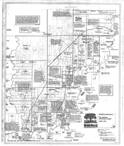
 Greensborough Historical Society
Map, Heidelberg. Historic River Landscape Assessment. Historical maps: Map C 1851-1863. "The Garden of the colony", 1985c
Geographical area of around 35 sq. kilometres marked with physical features such as major roads, vegetation and properties, with locations and notes of the increasing number of farms, gardens orchards and vineyards which had become established in addition to pastoral runs. Bounded by Shire of Diamond Valley to the North, Darebin Creek to the West and Plenty River to the East.Black and white sketch map on white paperheidelberg, heidelberg - maps -
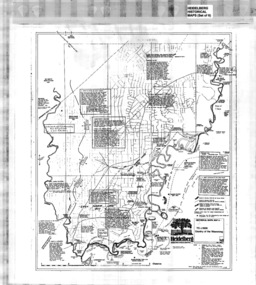
 Greensborough Historical Society
Map, Heidelberg: Historic River Landscape Assessment. Historical maps. Map E 1901-1934 "A Time of projects and improvements", 1985c
Geographical area of around 35 sq. kilometres marked with physical features such as major roads, railways (new extension to Eltham), rivers and properties, also housing sub-divisions and community facilities such as hospitals, parks and sporting reserves and indications of new small scale industries such as dairying. Bounded by Shire of Diamond Valley to the North, Darebin Creek to the West and Plenty River to the East. Black and white sketch map on white paperheidelberg, heidelberg - maps -
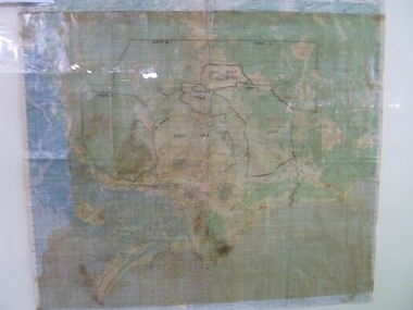
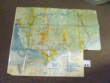 National Vietnam Veterans Museum (NVVM)
Map, C. 1969 - 70
Colour map of Vietnam with military locations shown.map, vietnam -
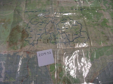 National Vietnam Veterans Museum (NVVM)
Map, A Contour Map of South Vietnam
A contour map showing ATF Base Patrols.atf base patrols -
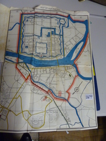 National Vietnam Veterans Museum (NVVM)
Map, Map of Hue
Folden up map of Hue with street namesmap, hue -
Whitehorse Historical Society Inc.
Map, Today's map of Mitcham, Nunawading, Blackburn, 1957
Folded detailed map of Mitcham, Nunawading, BlackburnFolded detailed map of Mitcham, Nunawading, BlackburnFolded detailed map of Mitcham, Nunawading, Blackburnmaps, mitcham, nunawading, blackburn, burwood east, forest hill, vermont -
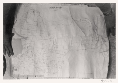 Queenscliffe Maritime Museum
Map - French Island, County of Mornington, French Island map photographs x 2, c1987
Islands off Victorian coastFrench Island mapFrench Island map photographs x 2Reverse " Nil "french island -
Stawell Historical Society Inc
Map, Tourist Map of Grampians/Halls Gap and Surrounds, 1928
Tourist Map of Grampians/Halls Gap and Surroundsstawell, tourism -
Stawell Historical Society Inc
Map, Land Map of Victoria 1898, Supplement to "The Leader", 1898
Land Map of Victoria 1898, Supplement to "The Leader"stawell -
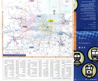 Melbourne Tram Museum
Map, Department of Infrastructure (DOI), "Melbourne's Public Transport Map", Jul. 1999
Map - 18 fold - 6 x 3 with colour map of public transport including buses, titled "Melbourne's Public Transport Map", published by the Department of Infrastructure, Effective July 1999. Gives rail and tram maps, information on tickets, zones (3 Number) Has The Met contact details and website. Has DOI and State Govt logos. Priced $2.trams, tramways, map, doi, melbourne, the met -
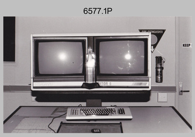 Bendigo Military Museum
Photograph - AITA Award - RA Svy’s AUTOMAP 2 Computer Based Map Production System, Army Survey Regiment, Fortuna, Bendigo, 1984
This collection of three photos of the Australian information Technology Award (AITA) won by the Royal Australian Survey Corps (RA Svy) AUTOMAP 2 computer-based map production system, was taken in 1984 at the Army Survey Regiment, Fortuna, Bendigo. The following article appeared in the ARMY Newspaper on Thursday 21st February 1985. ‘In computerised map production. Survey soldiers lead the world. BENDIGO: Army surveyors have been put on the map as world leaders in computerised map production following the Australian information Technology Awards. RA Svy won the Computer Assisted Draughting – Mapping section for its Automap II System which has created considerable interest among overseas defence experts. The award for the digital mapping system was accepted by OC Air Survey Sqn, MAJ Rob John, who said it was a great morale-booster for the soldiers of the Bonegilla (sic)* -based Army Survey Regiment. "Setting up a state-of-the-art system like Automap II. is an enormous task, " he said. "We started in August 1983 and it's only recently that we have achieved production results. "We were all very pleased to have our efforts recognised in this way. “Of course, credit must also go to the Intergraph Corporation for manufacturing the system and carrying out most of the development." RA Svy is responsible for producing all of Australia's maps used for defence purposes. Its topographical maps have a scale of 1:50,000 or 1:100,000 although Automap II has the capability of producing smaller scale maps - down to 1: 2,000,000. Automap II consists of three computers and three sub-systems: input, raster scanning, and graphic edit. The input sub-system has eight stereo plotters, two interactive graphic workstations and a system manager workstation. The stereo plotters use superimposition optics to digitise features from aerial photographs. It incorporates a voice recognition system so the operator can simply say "House", "Windmill", etc; and the relevant feature will be incorporated in the digital picture. Individual map separations are scanned and converted by the raster scanning sub-system to a digital raster image. This image is then converted to a graphics file in Intergraph format.’ *Note – the Army Survey Regiment was located in Bendigo, not Bonegilla as incorrectly stated in the article. The article appears on Page 137 of Valerie Lovejoy’s book 'Mapmakers of Fortuna – A history of the Army Survey Regiment’ ISBN: 0-646-42120-4. Additional history of the AUTOMAP 2 system with historic photographs is covered in pages 119, 137-143 and 157 of the 'Mapmakers of Fortuna’ book. See item 6223.23P for additional history and photographs of the AUTOMAP 2 system.This collection of three photos of the Australian information Technology Award (AITA) won by the Royal Australian Survey Corps (RA Svy)’s AUTOMAP 2 computer-based map production system, was taken in 1984 at the Army Survey Regiment, Fortuna, Bendigo. The photographs are printed on photographic paper and are part of the Army Survey Regiment’s Collection. The black and white photographs were scanned at 300 dpi. .1) - Photo, black & white, 1984, AITA Award sitting between the dual screens of an AUTOMAP 2 Graphic Edit Workstation. .2) - Photo, black & white, 1984, MAJ Job Johns (centre) and two of Intergraph Corporation IT engineers proudly hold the AITA Award next to an AUTOMAP 2 Graphic Edit Workstation. .3) - Photo, black & white, 1984, The AITA Award displayed on a pedestal in the Army Survey Regiment Officers Mess. .1P to .3P –No personnel are identified. ‘AITI Award to AUTOMAP II 1984’ annotated on cover sleeve. royal australian survey corps, rasvy, army survey regiment, army svy regt, fortuna -
 Falls Creek Historical Society
Map - Falls Creek Alpine Resort Map
Julian Newton-Brown arrived at Falls Creek in 1957. He had studied Pharmacy at Melbourne University. After developing a love for the mountains, Julian moved to Mt. Beauty and then Falls Creek. He worked for the SEC in the test laboratory at Rocky Valley reading weather instruments. By working several jobs, Julian was able to build a small lodge of 10 beds named “Arundel”, located at 18 Slalom Street, Falls Creek. The lodge is now the “Elk at Falls”. Arundel prospered and Julian extended it to include 32 beds and changed its name to "Julian’s” in 1961. When alcohol restrictions were eased in Falls Creek, Julian built a night club which he called “Big Julian’s” and later “THE MAN”. When Julian and his wife Beth retired and left Falls Creek, their son took over running the lodge. An active community man, Julian was a member of the Falls Creek Chamber of Commerce, a member of the SES, a stakeholder in Falls Creek, an author and a documentary maker. Julian Newton-Brown died in May 2020.This map is significant because it contains an image of Falls Creek Alpine Resort.A black and white map of Falls Creek Alpine Resort Map featuring a photo taken by Julian Newton Brown. A numbered legend is included at the bottom right corner.dawn ski club, accommodation falls creek, lodges falls creek, tom mitchell -
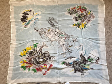 Phillip Island and District Historical Society Inc.
Scarf, Scarf with Map, flowers and animals of Phillip Island, c 1950's
Scarf possibly owned by Alice Robinson (nee Clark)Nylon scarf with map, flowers and animals of Phillip Island.Phillip Island and names of towns and places of interest.souvenir scarf, alice robinson -
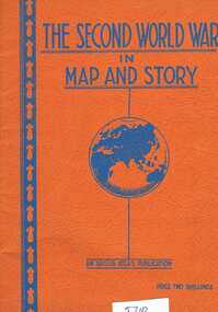 Greensborough Historical Society
Book, Neville Smith, The Second World War in map and story, ed. by Neville Smith, 1941_
Series of articles first published in the "Argus" from 1941 to 1945, dealing with events and campaigns in World War 2.63 p., black & white photographs, col. maps.world war 2 -
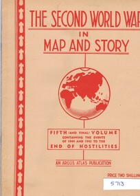 Greensborough Historical Society
Book, Neville Smith, The Second World War in map and story, Vol. 5, ed. by Neville Smith, 1945_
Series of articles first published in the "Argus" from 1941 to 1945, dealing with events and campaigns in World War 2.50 p., black & white photographs, col. maps.world war 2 -
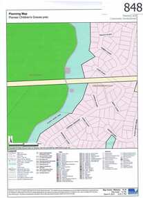 Greensborough Historical Society
Map, Plenty River Children's Cemetery - location map, 1848-1860
The unmarked graves of the children of two Greensborough pioneer families lie in a private cemetery on the Plenty River. Burials occurred between 1848 and 1860.The significance lies in the association with two of the pioneer families of the Greensborough district. Descendants of both families still live in the area.One page map accompanies article item #804 -
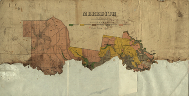 Federation University Historical Collection
Plan, Meredith Geological Map
Coloured map of Meredith backed onto sheets of paper.meredith, borhoneyghurk pre-emptive right, borhoneyghurk east pre-emptive right -
Moorabbin Air Museum
Map (item) - Aloha Airlines - map of the islands of Hawaii, Aloha Airlines - map of the islands of Hawaii circa 1955
-
Whitehorse Historical Society Inc.
Map, Heritage overlay map, 1/02/1999 12:00:00 AM
City of Whitehorse heritage review : Heritage overlay map.City of Whitehorse heritage review : Heritage overlay map.City of Whitehorse heritage review : Heritage overlay map.city of whitehorse, historic buildings, blackburn, blackburn south, blackburn north, mitcham, nunawading, forest hill, vermont, vermont south, burwood east -
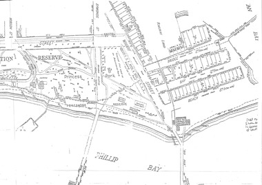 Queenscliffe Maritime Museum
Map - Port Phillip Bay at Queenscliffe 1936, Map of Queenscliffe Parks & Foreshore, unknown
Queenscliffe life c1936Map of Queenscliffe in c1936copy of an L-shaped map of 1936 Queenscliffe foreshoreReverse - " nil ".historical references -
Stawell Historical Society Inc
Map, Section of Map, Stawell including Stawell Rifle Range, 1969
Section of Map, Stawell including Stawell Rifle Rangestawell