Showing 476 items
matching parcel
-
 Ballarat Tramway Museum
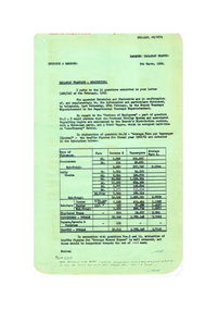
Document - Report, State Electricity Commission of Victoria (SECV), "Ballarat Tramways - Statistics", Mar. 1962
Yields detailed information about the statistics of the Ballarat Tramway system during the 1960/61 Financial year, passenger loadings, finances and tramcar operation..1 - Report titled "Ballarat Tramways - Statistics", carbon copy, dated 5/3/1962, responding to a head office letter of 6/3/1962. Compiled in association with Schedules and Statements required, in response to specific questions for compilation of reports by the SEC. Details types of passengers (Pensions, Adults, Scholars, chartered trams, passenger totals including parcels) for 1960/61. .2 - Four foolscap sheets giving details of fares and charges, route length, services, fare sections, length of fare sections, employees, trams in service, tram usage, area and population served, expenditure, revenue, loss, average fare per passenger and extra trams needed for events. Also refers to Reg Item 7932 and 7951 for the original request. All sheets have rounded corners.trams, tramways, reports, passengers, employees, fares, tramcars, routes, revenue, finances, tickets -
 Ballarat Tramway Museum
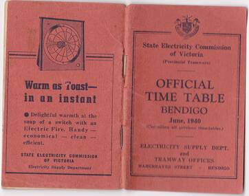
Photograph - Digital image, State Electricity Commission of Victoria (SECV), "Official Timetable Bendigo June 1940"
Yields information about the Bendigo Tram services.Digital image or copy of the SEC "Official Timetable Bendigo June 1940", 22 image files - 44 pages, giving details of the fares, transfers, luggage or parcels, lost property, times of each tram on the Quarry Hill, Eaglehawk, Lake Weeroona and Golden Square for both directions and Monday to Thursday, Friday, Saturday and Sunday. Has a number of advertisements for SEC home equipment, cookers, toasters, refrigerator, electric radiators and hot water. In the middle page is a map of the Tramway Routes, which has been hand drawn to shown North Bendigo and the depot location. Inside the rear cover, on a sheet headed "Memorandum" is a photograph, taped in of a conductor loading a pram onto a Birney tram. Under the photograph is in ink "Len Smith (Geelong)" See item3127 for an original copy and pdf scan. trams, tramways, bendigo, timetables -
 Ballarat Tramway Museum
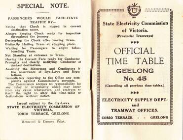
Photograph - Digital image, State Electricity Commission of Victoria (SECV), "Official Timetable Geelong No. 45"
Digital image or copy of the SEC "Official Timetable Geelong No. 45", 16 image files - 32 pages, giving details of the fares, transfers, luggage or parcels, lost property, times of each tram on the Belmont (1), Chilwell (2), East Geelong (3), Eastern Park (4), Newtown (5), North (6), West Geelong (7). Gives details of railway station trams, transfer ticket arrangements, depot workings and the night signs carried out each tram. Based on the 4d max fare, it is a circa 1949 timetable - see reference. See also Reg Item 5629 for Timetable No. 39, c1943 and 8552 for a photocopy of No. 47, March 1953. See BTM document, "SEC fare changes - by law references etc.doc, dated 3/9/2006.trams, tramways, geelong, timetables -
 City of Kingston
Photograph - Black and white, 20 December 1945
This aerial photograph depicts the changing landscape of Cheltenham and Highett since WWII. Photographed in 1945, there is a mix of urban dwellings and industrial development and precedes the major transformation of Cheltenham with the development of the Southland shopping centre in the 1960s and expansion in the 1990s.A large part of Cheltenham was originally established as a rural market gardening community. The railway line and station brought urban development to the area and in the north, the Highett area was dominated by the Highett Gas Works. Cheltenham became a major destination for shopping in the 1960s with the opening of Southland.Aerial photograph taken in 1945 of Cheltenham and Highett within the City of Kingston. The image includes the Highett Reserve, (top right), the Methodist Children Homes (now Southland), Nepean Highway and Jamieson Street. Highett Gas Works is visible in the top left and the land now named William Fry Reserve at the intersection of Bay Road and Nepean Highway. A visible large parcel of land on the corner of Bay Road and Nepean Highway was developed in the 1990s as the west side addition to Southland. The densely vegetated area in the upper right sector of the image is now dense with housing. Tulip Grove, Heather Grove and Gilford Street are visible bottom left. This image is possibly from the collection of aerial photographs commissioned by the Department of Crown Lands and Survey and taken by Adastra Airways.Black ink: 57252 White lettering: VIC-10 57252 20.12.45 [lens information indecipherable] PROJ. No.5 MELB. METROP AREA Black pencil: 80highett, cheltenham, highett gas works, urbanisation -
 City of Kingston
Photograph - Black and white, 20 December 1945
This aerial photograph depicts the changing landscape of Cheltenham and Highett since WWII. Photographed in 1945, there is a mix of urban dwellings and industrial development and precedes the major transformation of Cheltenham with the development of the Southland shopping centre in the 1960s and expansion in the 1990s.A large part of Cheltenham was originally established as a rural market gardening community. The railway line and station brought urban development to the area and in the north, the Highett area was dominated by the Highett Gas Works. Cheltenham became a major destination for shopping in the 1960s with the opening of Southland.Aerial photograph taken in 1945 of Cheltenham and Highett within the City of Kingston. The image includes the Highett Reserve, (top right), the Methodist Children Homes (now Southland), Nepean Highway and Jamieson Street. Highett Gas Works is visible in the top left and the land now named William Fry Reserve at the intersection of Bay Road and Nepean Highway. A visible large parcel of land on the corner of Bay Road and Nepean Highway was developed in the 1990s as the west side addition to Southland. The densely vegetated area in the upper right sector of the image is now dense with housing. Tulip Grove, Heather Grove and Gilford Street are visible bottom left. This image is possibly from the collection of aerial photographs commissioned by the Department of Crown Lands and Survey and taken by Adastra Airways.Black type: Reverse lettering VIC-10 57252 20.12.45 [lens information indecipherable] PROJ. No.5 MELB. METROP AREA White lettering: Reverse writing 57252cheltenham, highett, highett gas works, urbanisation -
 Federation University Historical Collection
Letter, F.W. Calaby, Letters from F.W. Calaby to School of Mines Ballarat, 18/07/1910
Clementston is a small gold town to the north of Creswick, Victoria. Formerly known as Beaconsfield, the Beaconsfield gold mining mullock heap is probably the sole remaining remnant of the village.Hand written noteClemontston 11/7/1910 Mr F.W. Martell Ser Sir, I am sending in a parcel of gold for smeling and sale with Mr Tolliday. Yours Faithfully F.W. Calaby. Clemontston, July, 18th 1910 Mr F.J. Martell Dear Sir I received your letter with cheque for 10 poinds 3 shillings 7 pence, also receipt for 5 shillings charges and I am very much obliged to you. Yours faithfully F.W. Calabyf.w. calaby, frederick martell, clementston, beacsonfield -
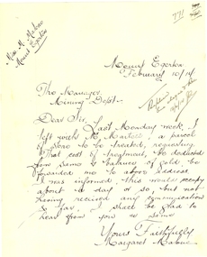 Federation University Historical Collection
Letter - Correspondence, Margaret Malone, Letter regarding gold assay from Mount Egerton Mine, 10/02/2014
Margaret Malone was associated with a kaolin mine at Mount Egerton. WOMAN WHO MANAGES A MINE Works With A Vision (By a Special Corespondent) BALLARAT, August 22.—Like a Heroine in a Bret Harte story of the Soaring: Forties Miss Margaret Malone, the only woman mine manager in Australia, has lived most of her life in an atmosphere where hope springs eternal in the gold-seeking breast. Forty years ago her father gave up farming to seek the elusive mineral near Ballarat. "One day my mother went for a walk along the Gordon-Egerton road and picked up a pebble with a few specks of gold in it," she told an interviewer yesterday, recounting the early history of the nine she now runs at Egerton. "Dad said, There must be more where that came from,' and hopefully sank a shaft. Our hopes were dashed, however, when he found only white clay. No one realised then the value of the disappointing looking white stuff which was all that Dad could find from every shaft he sank. At last be gave up the search, and the kaolin remained untouched." Later an Englishman from a pottery town in the old country urged Mr. Malone to try and sell his clay, and he sent some to the Bendigo potteries, but nothing came of it, and it was left to Miss Malone, after her father's death, to start on her unusual career by finding purchasers in Sydney and Melbourne for her clay, and herself working the mine. Strenuous Work "Mine managing is strenuous work in more ways than one," she admitted. "I have, to go down my mine daily, ad sometimes have to descend perpendicular ladders for about 150 ft. to reach areas being worked. I have to be my own manager, she explained, "because it is necessary to teach the men I employ the methods of grading clays." A New Cure She is convinced that a number of uses for kaolin, apart from pottery, soap and drugs, are yet to be discovered. "One of my employees has already found a new use for it," she said, "although scarcely one to be generally recommended, perhaps. By chewing a small piece of the clay he firmly believes that he "cured himself of heart burn." "All That Glistens" There is more in Miss Malone's mining than meets the eye, however. The actual working of the field and the substantial profit she makes on it do not fill her days. Always before her - dangles the compelling vision that caused her father, in his day, to give up farming to seek for gold. "All the time I am getting my clay dug," she confessed, "1 am watching for the colour of gold. One of these days I may strike it." WOMAN WHO MANAGES A MINE Works With A Vision (By a Special Corespondent) BALLARAT, August 22.—Like a Heroine in a Bret Harte story of the Soaring: Forties Miss Margaret Malone, the only woman mine manager in Australia, has lived most of her life in an atmosphere where hope springs eternal in the gold-seeking breast. Forty years ago her father gave up farming to seek the elusive mineral near Ballarat. "One day my mother went for a walk along the Gordon-Egerton road and picked up a pebble with a few specks of gold in it," she told an interviewer yesterday, recounting the early history of the nine she now runs at Egerton. "Dad said, There must be more where that came from,' and hopefully sank a shaft. Our hopes were dashed, however, when he found only white clay. No one realised then the value of the disappointing looking white stuff which was all that Dad could find from every shaft he sank. At last be gave up the search, and the kaolin remained untouched." Later an Englishman from a pottery town in the old country urged Mr. Malone to try and sell his clay, and he sent some to the Bendigo potteries, but nothing came of it, and it was left to Miss Malone, after her father's death, to start on her unusual career by finding purchasers in Sydney and Melbourne for her clay, and herself working the mine. Strenuous Work "Mine managing is strenuous work in more ways than one," she admitted. "I have, to go down my mine daily, ad sometimes have to descend perpendicular ladders for about 150 ft. to reach areas being worked. I have to be my own manager, she explained, "because it is necessary to teach the men I employ the methods of grading clays." A New Cure She is convinced that a number of uses for kaolin, apart from pottery, soap and drugs, are yet to be discovered. "One of my employees has already found a new use for it," she said, "although scarcely one to be generally recommended, perhaps. By chewing a small piece of the clay he firmly believes that he "cured himself of heart burn." "All That Glistens" There is more in Miss Malone's mining than meets the eye, however. The actual working of the field and the substantial profit she makes on it do not fill her days. Always before her - dangles the compelling vision that caused her father, in his day, to give up farming to seek for gold. "All the time I am getting my clay dug," she confessed, "1 am watching for the colour of gold. One of these days I may strike it." (WOMAN WHO MANAGES A MINE Works With A Vision (By a Special Corespondent) BALLARAT, August 22.—Like a Heroine in a Bret Harte story of the Soaring: Forties Miss Margaret Malone, the only woman mine manager in Australia, has lived most of her life in an atmosphere where hope springs eternal in the gold-seeking breast. Forty years ago her father gave up farming to seek the elusive mineral near Ballarat. "One day my mother went for a walk along the Gordon-Egerton road and picked up a pebble with a few specks of gold in it," she told an interviewer yesterday, recounting the early history of the nine she now runs at Egerton. "Dad said, There must be more where that came from,' and hopefully sank a shaft. Our hopes were dashed, however, when he found only white clay. No one realised then the value of the disappointing looking white stuff which was all that Dad could find from every shaft he sank. At last be gave up the search, and the kaolin remained untouched." Later an Englishman from a pottery town in the old country urged Mr. Malone to try and sell his clay, and he sent some to the Bendigo potteries, but nothing came of it, and it was left to Miss Malone, after her father's death, to start on her unusual career by finding purchasers in Sydney and Melbourne for her clay, and herself working the mine. Strenuous Work "Mine managing is strenuous work in more ways than one," she admitted. "I have, to go down my mine daily, ad sometimes have to descend perpendicular ladders for about 150 ft. to reach areas being worked. I have to be my own manager, she explained, "because it is necessary to teach the men I employ the methods of grading clays." A New Cure She is convinced that a number of uses for kaolin, apart from pottery, soap and drugs, are yet to be discovered. "One of my employees has already found a new use for it," she said, "although scarcely one to be generally recommended, perhaps. By chewing a small piece of the clay he firmly believes that he "cured himself of heart burn." "All That Glistens" There is more in Miss Malone's mining than meets the eye, however. The actual working of the field and the substantial profit she makes on it do not fill her days. Always before her - dangles the compelling vision that caused her father, in his day, to give up farming to seek for gold. "All the time I am getting my clay dug," she confessed, "1 am watching for the colour of gold. One of these days I may strike it." (Adelaide Observer, 31 August 1929.)Hand written letter from Margaret Malone of the Mount Egerton Mine.Mount Egerton Mine February 10/14 The Manager Mining Dept Dear Sir, Last Monday week, I left with Mr Martell, a parcel of stone to be treated, requesting that cost of treatment, be deducted from some and balance of gold be forwarded me to above address. I was informed, this would occupy about a day or so, but not having received any communication so far, I shall be glad to hear from you are same. Yours faithfully Margaret Malonemargaret malone, female mine manager, kaolin, mount egerton, women -
 Eltham District Historical Society Inc
Photograph, Stokes family, Nyora Road, Eltham, c.1952, 1952c
Taken from outside the family home on the southest corner of the intersection of Nyora Road and Pitt Street with Eucalyptus Road, looking northeast across the Stokes Orchard L-R: David, Howard, Beryl (kneeling), Dorothy and Gladys Stokes with Gladys's mother sitting in Gladys's father's car with Spot the dog, Nyora Road, Eltham, c.1952 Frank Stokes first traveled to the district by train in 1944 to find land with the intention to establish an orchard. By chance he met Arthur Bird of Bird Orchard (bounded by Pitt Street, Eucalyptus Road and Wattle Grove) and they got talking over their common interest. Arthur put Frank up for the night and pointed out the land, part of Crown Allotment 15, Section 5, Parish of Nillumbik (CA15) somewhat diagonally opposite Bird Orchard. Frank bought the land and for the next two years would travel by train from Melbourne to Eltham every weekend establishing Stokes Orchard and building a home for his family, which they eventually moved into in 1946. In the mid 1970s the Shire of Eltham divided the orchard up into numerous rate-able parcel lots, which became affordable for Frank. As a consequence Stokes Orchard was turned into a housing development by Macquarie Builders and marketed as the Stokes Orchard Estate in two stages; Stage 1 encompassing Scarlet Ash Court, Ironbark Close and Peppermint Grove bounded by Nyora and Eucalyptus roads c.1976 and Stage 2 encompassing Stokes Place, Orchard Way, The Crest and The Lookout bound by Nyora and Diosma roads c.1979. The development of Orchard Way, The Crest and The Lookout did not proceed as planned due to the lack of the sewer along Diosma Road and so many of the proposed lots were incorporated into five-acre parcels instead.Representative of the orchard growing areas of ElthamDigital file only - Digitised by EDHS from a scrapbook (containing commercially printed photos of digital scans) on loan from Beryl Bradbury (nee Stokes), daughter of Frank Stokes.1948-1951 vauxhall velox, 1948-1951 vauxhall wyvern, 1952, beryl bradbury (nee stokes), beryl bradbury (nee stokes) collection, david stokes, dorothy stokes, eltham, gladys stokes, nyora road, spot (dog), stokes orchard -
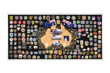 Department of Energy, Environment and Climate Action
Display board
The Forests Commission and its successors continuously encouraged bushfire research and innovation. In 1946 a large parcel of industrial land was purchased at North Altona as a fire cache and workshop. The Altona workshop became a hotbed of new technological innovation… an exhilarating place where lots of things were invented and tested. In fact, a lot of Australia’s pioneering equipment development was led by staff from Altona, often in collaboration with other State forestry and fire authorities. The CSIRO also contributed significantly. The US Forest Service, the US Bureau of Land Management and US State agencies such as the California Department of Forestry and Fire (CalFire) as well as the Canadian Forest Service faced similar challenges and proved strong and willing partners in sharing knowledge, ideas, equipment and expertise over many decades. This collection of badges is testament to the relationships that were forged across the globe with the Altona workshop. Large display panel featuring many fire service badgesforests commission victoria (fcv), bushfire, bushfire aviation -
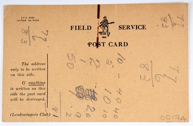 Melbourne Legacy
Postcard, Field Service Post Card
A humorous post card intended to emulate an official army issued post card used for soldiers to quickly send information home. However the options given on the humorous postcard are contradictory. Postcards were a very common form of communication in the first World War. Postcards as souvenirs or as correspondence would have been familiar to the first Legatees as they had served in World War 1.Brown card with printed with black text. Side A Nothing is to be written on this side unles it is of useful information to the Enemy or your lady friends. If anything is written on this card it will be destroyed. In any case it will not be forwarded. I am quite well (?) I wish I were dead I am dead I have been dead for some time I am not yet shot I wish I were shot I hope to be shot I am shot The Q.M. has recieved the parcel you sent me Please forward 5 pounds/ 10 pounds/ 20 pounds/ 50 pounds (strike out the sum not required) I am in Hospital. She is/is not lovely. Signature (Must be Embossed) Date _ Side B The address only is to be written on this side. If anything is written on this side the post card will be destroyed. (Leadswingers Club)Pencil markings on side B appear to be numbers used to tally something.war correspondence, world war one, souvenir -
 Ballarat Tramway Museum
Book, State Electricity Commission of Victoria (SECV), "Electric Tramways of the State Electricity Commission of Victoria Amendment to By-Law January 1962", Jan. 1963
Twelve page booklet, plus medium weight card covers. Book cover has title "Electric Tramways of the State Electricity Commission of Victoria Amendment to By-Law January 1962". Pages are numbered pages 1 to 9 amending the 9/3/1937 By-Laws. Used to revise fares, parcel and luggage and charter rates in for Bendigo and Ballarat from 1/3/1963. Page 1 gives a list of amendments by date to the original by-law of 9/3/1937. Defines Pensioners and Child fares. Booklet dated January 1962, SEC Sealed the document 18/1/1962, Governor-In-Council approval granted 15/1/1963 and came into force 1/3/1963. Six copies held See Fares in Ballarat – from Alan Bradley 11/4/2005 – appendix for Book Two copies (2 and 3) have written in pen on top right hand side of book "Ballarat Tramway Preservation Society Catalogue No. 205" and one copy (No. 5) "1962" on top of cover. Copy 3 has a formula in red ink on back cover.trams, tramways, secv rules, by laws, tickets, fares, ballarat, bendigo -
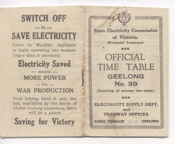 Ballarat Tramway Museum
Ephemera - Timetable, "Official Timetable Geelong No. 39", 1943
Printed, single stapled 8 sheets folded and titled SECV "Official Timetable Geelong No. 45", 16 image files - 32 pages, giving details of the fares, transfers, luggage or parcels, lost property, times of each tram on the Newtown, West Geelong, East Geelong, Chilwell, Eastern Park, Belmont,, North, . Gives details of fares, luggage, lost property. On rear has an SECV Advert to "Switch Off to Save Electricity - Saving for Victory" Timetable undated, probably c1943 - see Reg Item 5633 for date forwarded to Wal Jack from Geelong SECV office - was the then current timetable. See also Reg Item 5357 for Timetable No. 45, c1949 and 8552 for a photocopy of No. 47, March 1953. Contained originally within Reg Item 5623 at the front of this note book. For items see btm5623 loose items list.pdfgeelong, timetables -
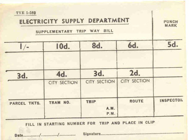 Ballarat Tramway Museum
Document - Form/s, State Electricity Commission of Victoria (SECV), "Supplementary Trip Way Bill", early 1960's
Yields information about the form used in Ballarat and Bendigo by the SEC to enabling ticket checking by Inspectors on the trams.Single sheet of paper titled "Supplementary Trip Way Bill", form No. TYE 1-580, for filling in ticket starting numbers, for tickets from 2d (City Section) through to 1/- value. Also allows for parcel tickets, tram no, trip, route, inspector and punch marks. Has line for filling in date and signature at base of ticket. Used in early 1960's. Max. fare 1/- Item was on display in cabinet of 39 until 10/2004, ex filing cabinet 1992. Two copies held. See also Reg. Item 279. See also Reg. Item 3062 for another sample - 15c max value. See Also Reg Item 4144 for a MMTB version, very similar in style, SEC probably copied it. See Also Reg item 5692 for a pack of 250 of these.trams, tramways, secv rules, by laws, tickets, fares, ballarat, bendigo -
 Bendigo Historical Society Inc.
Document - LYRIC THEATRE, MYER'S PATRIOTIC WORKERS' SOCIETY, 20 September, 1917
Lyric Theatre, Myer's Patriotic Workers' Society. Grand Concert, Thursday, September 20th, 1917, 8pm. Admission 2/- (Entitling to Reserve) and 1/-. Musical Director: Mr E H Collett. Leader of Orchestra: Mr O Flight. Accompanist: Miss MacGillivray. Home Made Confectionery will be sold by Ladies. Programme: God Save the King. Part I: 'Trumpet of the Fort' 'Angles Guard Thee' 'Where my Caravan has rested' 'Villanell' 'Le Babillard' 'Hark to the Mandolin' 'Come Back, One Day'. Part II: 'Sunshine and Showers' unnamed song, 'Prologue', 'Spirit of the Wood' 'They Sang God Save The King' 'Hullamzo Balaton' 'The Two Grenadiers' 'Farwell to Summer'. Overtures: Lyric Orchestra. Songs: Mr EH Collett, Miss Elsie Code, Miss Winnie Mayberry, Mr J Warren, Mr F Monaghan, Mr H S Barkell. Duets: Misses c Ronan and J Sherlock, Misses J Pearson and L Bain, Miss E Code and Mr H S Barkell, Miss W Mayberry and Mr E H Collett. Flute Solo: Mr A E Sayer. Violin Solo: Miss Myrtle Knight. God Bless Our Splendid Men. Back Cover- Myer's Patriotic Workers' Society was formed by the Employees of Myer's' Bendigo, with the object of forwarding comforts to the soldiers from the Bendigo district who have joined the Australian Imperial Forces. Names were invited from the public, when no less than twelve hundred names were recorded, and the Society is making every effort to despatch the parcels as quickly as possible. So far six hundred and fifty parcels have been sent at a cost of 10/- (plus postage, 2/-) each The proceeds of this Concert go towards augmenting the funds of the Society to carry out this obligation.Bolton Bros. Printers, Bendigoprogram, theatre, lyric theatre -
 Eltham District Historical Society Inc
Photograph, The Stokes family home and orchard blanketed with snow, corner Nyora and Eucalyptus roads, Eltham, Winter 1951, 1951
Taken from outside the family home on the southest corner of the intersection of Nyora Road and Pitt Street with Eucalyptus Road. Frank Stokes first traveled to the district by train in 1944 to find land with the intention to establish an orchard. By chance he met Arthur Bird of Bird Orchard (bounded by Pitt Street, Eucalyptus Road and Wattle Grove) and they got talking over their common interest. Arthur put Frank up for the night and pointed out the land, part of Crown Allotment 15, Section 5, Parish of Nillumbik (CA15) somewhat diagonally opposite Bird Orchard. Frank bought the land and for the next two years would travel by train from Melbourne to Eltham every weekend establishing Stokes Orchard and building a home for his family, which they eventually moved into in 1946. Marjorie North remembered well the winter of 1951, when she took children, including son John together with the Shallard and Squire children “in the Austin A40 up the Main Rd., Eltham to farmer Bell’s property alongside the Eltham College. They were able to make a snow man and throw snowballs. (Diamond Valley News, August 5, 1986.p.42) In the mid 1970s the Shire of Eltham divided the orchard up into numerous rate-able parcel lots, which became affordable for Frank. As a consequence Stokes Orchard was turned into a housing development by Macquarie Builders and marketed as the Stokes Orchard Estate in two stages; Stage 1 encompassing Scarlet Ash Court, Ironbark Close and Peppermint Grove bounded by Nyora and Eucalyptus roads c.1976 and Stage 2 encompassing Stokes Place, Orchard Way, The Crest and The Lookout bound by Nyora and Diosma roads c.1979. The development of Orchard Way, The Crest and The Lookout did not proceed as planned due to the lack of the sewer along Diosma Road and so many of the proposed lots were incorporated into five-acre parcels instead.Representative of the orchard growing areas of Eltham. One of the rare times it has snowed in Eltham.Digital file only - Digitised by EDHS from a scrapbook (containing commercially printed photos of digital scans) on loan from Beryl Bradbury (nee Stokes), daughter of Frank Stokes.1951, beryl bradbury (nee stokes) collection, eltham, nyora road, eucalyptus road, snow, stokes family home -
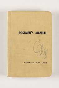 City of Greater Bendigo - Civic Collection
Manual, Post Master General's Department, Postmen's Manual, 1964
When the Commonwealth Post and Telegraph Act was passed in June 1902, and a national Postmaster General's Department (the PMG) was established the responsibility for the nation's mail and telephone services fell on Post Offices. The Bendigo Post Office, built in 1887 and situated on Pall Mall was the central distribution centre for receiving and delivering telegrams and continued to deliver communication and postal services until 1997. Now a Visitor Centre, dedicated volunteers at the Post Office continued to demonstrate and educate the public about the daily workings of the Post Office up until 2019 when Covid 19 disrupted every day life and Ted Rankins, the last Post Master and a long term telegraph volunteer at the Post Office, died. Manuals were issued to postmen to guide them in the delivery of letters and parcels and were small enough to be carried with them. This manual was used by the Bendigo Post Office postmen and is part of the postal collection donated by the Rankins family in memory of Ted Rankins,. Small, creamed coloured cloth covered manual. Contains forty four printed pages and two blank end pages covering all aspects of how to correctly deliver the post. Topics include 'Behaviour', 'Deceased Persons' and 'Bicycles' amongst many others. Book is bound and contains many extra additional paragraphs stuck in on appropriate pages noting changes and amendments. Additional amendments in handwritten red pen also occur on pages 28, 29 and 36.Front cover; Postmen's Manual / Australian Post Office Various annotations and updates throughout. ted rankins collection, bendigo post office, bendigo tourism, city of greater bendigo tourism, post office collection -
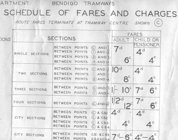 Ballarat Tramway Museum
Poster, State Electricity Commission of Victoria (SECV), "Schedule of Fares and Charges - 11 August 1965", Aug. 1966
Dye line print of a drawing showing Bendigo Tramways (SEC) Fares, Charges, and Section Map. Also gives charges for Scholar's Monthly tickets, Luggage, Parcels, Newspapers and Chartered trams. Dated 11 August 1965. Fares in shillings and pence and decimal currency. Titled - "Schedule of Fares and Charges - 11August 1965". Shows offices as Hargreaves St. For map - see bgofsmap.jpg and for actual fare tables, btm1732i1.jpg and btm1732i2.jpg. .1 - Second copy from Ron Fluck, added 26/9/2008. Note: 1732 - first copy stored rolled, 1732 - 2nd copy stored flat in box at bottom of rolls. .2 - as above but mounted onto a heavy card sheet with wear marks along the bottom edge - see image i3. Stored as for the 2nd copy. Note: 1732 - first copy stored rolled, 1732 - 2nd copy stored flat in box at bottom of rolls, .3 dittotrams, tramways, bendigo, fares, sections, map -
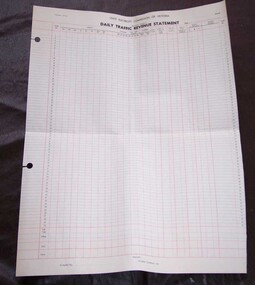 Ballarat Tramway Museum
Document - Form/s, State Electricity Commission of Victoria (SECV), "Daily Traffic Revenue Statement", 1966
3054 - Printed form titled "Daily Traffic Revenue Statement" of the SEC, Electricity Supply Department, Provincial Tramways, on off white heavy duty paper. Gives value of tickets up to 15c, , scholar and parcel tickets, special trams, value of tickets issues, cash paid in by conductor, value of tickets collected, surplus or deficiency and hospital vouchers and Outfit number of either side of the form. Has space for branch, as at date, with signatures of Compiler. Form has number TRM 583-1 (OP109) , with two large holes on left hand side for holding or filing into accounts books. Form ruled in blue ink horizontally and red ink vertically with some horizontal lines. A similar form, printed only in black, without the holes also donated by Peter Watt. Has fare values up to 18c. Layout of form identical. This form has been imaged (i2) and passed onto to Bendigo Tramways.trams, tramways, tickets, accounting, conductors -
 Kew Historical Society Inc
Plan - Subdivision Plan, Camberwell Mountain View Estate, 1923
The Kew Historical Society collection includes almost 100 subdivision plans pertaining to suburbs of the City of Melbourne. Most of these are of Kew, Kew East or Studley Park, although a smaller number are plans of Camberwell, Deepdene, Balwyn and Hawthorn. It is believed that the majority of the plans were gifted to the Society by persons connected with the real estate firm - J. R. Mathers and McMillan, 136 Cotham Road, Kew. The Plans in the collection are rarely in pristine form, being working plans on which the agent would write notes and record lots sold and the prices of these. The subdivision plans are historically significant examples of the growth of urban Melbourne from the beginning of the 20th Century up until the 1980s. A number of the plans are double-sided and often include a photograph on the reverse. A number of the latter are by noted photographers such as J.E. Barnes.The so-called Camberwell Mountain View Estate was a subdivision on ‘the corner [of] Burke Road, Eyre and Wills Streets, Deepdene’. The Estate was not the first attempt to subdivide this land holding. In 1884, 1888 and 1894 the Belmore Park subdivision proposed 18 allotments for this parcel of land. The final stages of the Belmore Park subdivision occurred during the Depression of the 1890s. Apart from perhaps one block facing Burke Road, which is unnumbered in the Mountain View Estate subdivision, the rest must have remained unsold. The later subdivision would redraw the original 18 allotments, creating 22 new lots. In the Locality Plan on the left side of the subdivision plan, Deepdene Station, which formed part of the Outer Circle Railway is represented, as is the location of Deepdene Primary School. A selling point was the proposed extension of the Burke Road tram beyond its terminus at Cotham Road. The extension did not eventuate.subdivision plans - camberwell, mountain view estate -
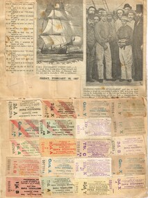 Melbourne Tram Museum
Ephemera - Ticket/s and Newspaper Clipping, John Stanley Caddell, How St Kilda welcomed the King and Queen, c1927
Tickets and newspaper clippings glued to a folded sheet of cardboard comprising: Inside: 20 - MMTB Cable and Electric tram through tickets - transfer and priced, all numbered. Newspaper clipping from Friday Feb 18, 1927 - HMAS Bacchante under sail and Bearded Pioneers at Ballarat. Outside: 4 MMTB ES (Eastern System) tickets - different colours, un-priced, all printed as between Regent St and High St. 1 - Transfer ticket - blue, punched for "to Northcote Town Hall". 1 - MMTB Scholar's concession check - block - printed for Prahran, Malvern and Hawthorn Electric Tramways Newspaper cuttings - How St Kilda welcomed the King and Queen - 6/5/1901 - Duke and Duchess of Cornwall and York. and a cartoon, of an overloaded cable tram trailer with a gentlemen carrying a bag marked CRB and many parcels with the conductor asking "Fares Please!", drawn by Percy Leason.trams, tramways, tickets, cable trams, transfer tickets, cartoons, regent st, crb, royal visit -
 Bendigo Military Museum
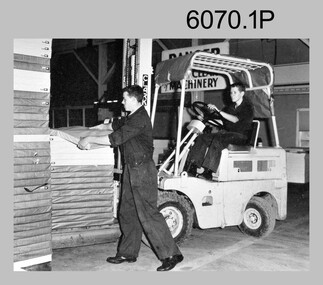
Photograph - Maps despatched by Printer Technicians at the Army Survey Regiment, c1970s to c1990s
These nine photographs of Printer Technicians working on the despatch of bulk printed map stock to customers, were probably taken circa 1970s to 1990s in Lithographic Squadron at the Army Survey Regiment, Fortuna, Bendigo. Except for photo .3P, personnel are not annotated on the photos. Despatch was the final task performed by a team of Printer Technicians. It involved the wrapping of trimmed bulk maps into manageable parcels and sending them by freight to customers or to the Army Map Depot at Bandiana, VIC. The task’s Due date and sensitivity were essential considerations in the planning of production affecting the lead time and method of delivery. Freighting by commercial means was the normal method for routine tasks. The method of despatch for urgent time-critical tasks sometimes meant having to use military freight or safe-handed by Army Survey Regiment personnel. The mishap captured in photos .6P and .7P was rare, but costly if it was a time critical task. The Print Room’s Map Handling Station in photos .8P and .9P provided ergonomic benefits to the Printer Technician and improved despatch productivity.This is a set of photographs of Printer Technicians involved in the despatch of bulk printed map stock c1970s to c1990s. The photographs were printed on photographic paper and are part of the Army Survey Regiment’s Collection. The photographs were scanned at 300 dpi. .1) - Photo, black & white, c1970s, L to R: unidentified, unidentified, Lithographic Squadron .2) - Photo, black & white, c1980s, Steve Egan, Lithographic Squadron .3) - Photo, black & white, c1980s, L to R: unidentified, Kim Reynolds, Lithographic Squadron .4) - Photo, colour, c1980s, L to R: Jeff Willey, Gary Kerr, Lithographic Squadron .5) - Photo, black & white, c1980s, L to R: Jim Ash, Mark ‘Dogs’ Doherty, Stuart Ridge, Lithographic Squadron .6) - Photo, colour, c1980s, printed maps toppled, Lithographic Squadron .7) - Photo, colour, c1980s, printed maps toppled, Lithographic Squadron .8) - Photo, black & white, c1990s, L to R: unidentified, unidentified, Lithographic Squadron .9) - Photo, black & white, c1990s, unidentified, Lithographic Squadron .3P, personnel annotation on back. .1P, .2P, .4P, .5P, .8P and .9P – no personnel annotated .6P and .7P – ‘Good one Daryl’ annotated on back.royal australian survey corps, rasvy, army survey regiment, army svy regt, fortuna, asr, litho, printing -
 Kew Historical Society Inc
Plan - Subdivision Plan, J R Mathers & McMillan, Plan of Subdivision of Part of Crown Portion 83 at Kew : LP6669, 1923-1939
In 1888, in the section of Park Hill Road between Belmont Avenue and Normanby Road there was only one street running between Park Hill Road and Cotham Road. This was Park Road, later to be named Adeney Avenue. Subsequent 20th century subdivisions created the ‘through roads’ of Cecil Street, Wimba Avenue, Florence Avenue, Marshall Avenue, Uvadale Road, and Barrington Avenue. This subdivision represents an attempt by auctioneers, rather than town planners to create an urban environment from larger residential allotments or in many cases farmland. Existing streets such as Parkhill and Normanby Roads provided a convenient starting point for the surveyors, but the Road named ‘Street Street’ indicates the role of the private surveyor in creating streets. Given that a number of allotments are listed as sold on the plan, the street is presumably Cecil Street. Even those lots that had been sold do not quite match the dimensions of the blocks in this parcel of land today, indicating that either further subdivisions or boundary alterations occurred.Subdivision plans are historically important documents used as evidence for the growth of suburbs in Australia. They frequently provide information about when the land was sold as well as evidence relating to surveyors and real estate and financial agents. The numerous subdivision plans in the Kew Historical Society's collection represent working documents, ranging from the initial sketches made in planning a subdivision to printed plans on which auctioneers or agents listed the prices for which individual lots were sold. In a number of cases, the reverse of a subdivision plan in the collection includes a photograph of a house that was also for sale by the agent. These photographs provide significant heritage information relating house design and decoration, fencing and household gardens.The photograph may also be aesthetically significant depending on the importance of the photographic atelier.Hand-drawn subdivision plan of 19 lots facing Parkhill Road, Normanby Road, and an unnamed street [now Cecil Street] in Kew.Estate Agent notes in ink indicate those lots which had sold.subdivision plans - kew, parkhill road - kew, cecil street - kew, normanby road - kew, cecil street -kew, parkhill road - kew, normanby road - kew, crown portion 83 - kew -
 Bacchus Marsh & District Historical Society
Map, Plan of the property of Messers Atkins and Clarke to be sold at the Mansion, Bacchus Marsh 19th April 1856. Copy 1
This plan of land allotments for sale indicates the property once owned by the Bacchus family in and around the township area of Bacchus Marsh. The Bacchus family sold their property in Bacchus Marsh to John Atkins and Robert Nalder Clarke in March 1851. Atkins and Clarke kept the property for a number of years until April 1856 when these allotments were put up for sale.This plan is almost identical to another copy held by the Bacchus Marsh and District Historical Society, VC Record 452, BMDHS collection). This plan, VC Record 707 Copy 1, contains a little more detail overall than VC Record 452 Copy 2, such as who did the survey work for the plan (R.C. Bagot) and who the selling agents were, (W.M. Tennent), and on the right side of the plan near the Lerderderg River is indicated the general area for a second parcel of land from this sale which is to be sold. There is also a compass illustration indicating north and south compass points.This is a very early land sales plan for the township of Bacchus Marsh and it therefore provides some clues as to how the early urban development of the township took place. Upon seeing the map in 1911 Bacchus Marsh Express newspaper editor Christopher Crisp wrote "The sale appears to have created the present township, which had a nucleus in earlier times further east", Express, 30 September, 1911, page 3.A single page paper plan showing allotments of land for sale. The subdivided land shown was owned by John Atkins and Robert Nalder Clarke, but previously owned by the Bacchus Family and was in and around their Manor House (Mansion) property in Bacchus Marsh.There are 5 portions of land further divided into numerous small portions. The land for sale is bounded by the present day streets of Main Street, Young Street, McFarland Street, Morton Streets, Crook Street, and part of the eastern section extends to the Lerderderg River. Scale: 8 chains to 1 inch The plan is pasted into a bound volume containing 76 maps or plans in total. BMDHS Loc: AR/B12/S4 Bacchus Marsh Township and Nearby Districts Maps Volume In-house Digital copies: BMDHS, Computer Network: Maps\Bacchus Marsh Township and Nearby Districts Maps VolumeHeading: Plan of the first portion of land. The property of Messers Atkins and Clarke situate at Bacchus Marsh. To be sold by W.M. Tennent & Co. at the Mansion on the Ground on Saturday the 19th April 1856. Below heading: Jas Ferguson, Lithographer On upper right side: Subdivided by R.C. Bagot London and Liverpool Chambers, Melbourne. 'Thos Taubman'. Post Office Stamp: BACCHUS MARSH VICTORIA MY 6, 63bacchus marsh victoria maps, bacchus family, land sales, manor house bacchus marsh -
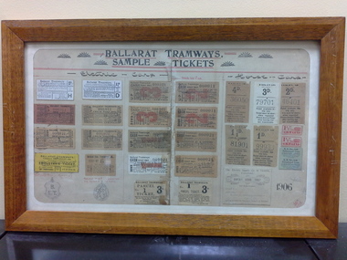 Ballarat Tramway Museum
Ephemera - Framed tickets, Electric Supply Co. of Vic (ESCo), "Ballarat Tramways - Sample tickets", 1906, 1966
Demonstrates and yields information about the ESCo tickets of 1906, shows the variety of tickets and passes used.Framed - wooden surround, glass, set of 26 actual tickets and two sketches of passes, timber backing board with the title "Ballarat Tramways - Sample tickets", dated 1906. Sets out the various tickets used by ESCo at the time and most likely used as a training aid for new conductors on both the electric and horse trams. Not to be displayed in light or hung up, that is display with care as fading is likely. See history of the object for details of the frame etc. Image i1 - as received from the City of Ballarat i2 - as repaired by by Kosnar's Picture framing. i3 - close up on the writing on the rear of the backing sheet i4 - detailed (1200dpi) image of the tickets. - 26.6 M i5 - image of the rear as received i6 - ditto - 600 dpi (Suitable for e-mail) - 7.2Mb See Reg Item 1846 for the newspaper clipping of Les Denmead handing the framed set of tickets to the City of Ballarat on 21/9/1971. Tickets comprise: Electric Tram Top Row: 2d - white - letter H - strip ticket requiring a trip ticket of the same value to be issued. 1 1/2d - white letter D - strip ticket requiring a trip ticket of the same value to be issued. 3d - off white, number 000,021 - Cash Adult - Up 2d - off white, number 000011 - Cash Adult - Up 2nd row 2d - check ticket - light red paper - number 000,011 - Up 1 1/2d - off white paper, number 000,011 - Up 3d - off white, number 000,021 - Cash Adult - Down 2d - off white, number 000011 - Cash Adult - Down 3rd row 2d - check ticket - off white paper - number 000,021 - Down 1 1/2d - check ticket - off white paper - number 000,021 - Down 1d - off white - number 000009 cash - child Up ticket 2d - off white - number 000021 cash - child Up ticket 4th row Employees only ticket - yellow, strip ticket School ticket - off white strip ticket - No. 6 1d - off white - number 000021 cash - child Down ticket 2d - off white - number 000021 cash - child Down ticket 5th row Drawing of Employees Bronze Medallion Drawing of pass issued to City Councillors and Officers of the Company Parcel ticket - No. 1 - 3d - to be attached to the parcel Parcel ticket - No. 1 - 3d - issued to the sender Horse Tram tickets 1st row 4d - off white paper - 36050 3d - white paper - 79701 2d - off white paper - 46401 2nd row 1 1/2d - off white - 81901 1d - off white - 99933 two 1 1/2 strip ticket - red two 4d daily return ticket - blue paper strip ticket 3rd row Monthly School ticket Sheet dated 6-9-06 with the initials SHS. "on the inside of the frame object was "Restored (?) and framed by Keith Russell Anderson, SEC Ballarat 26 Aug.1966"trams, tramways, tickets, esco, city of ballarat -
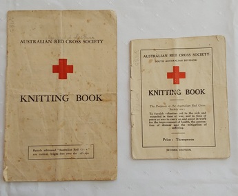 Mont De Lancey
Booklet - Knitting Patterns, Australian Red Cross, Australian Red Cross Society Knitting Book, c.1940's
Two Australian Red Cross knitting pattern booklets for home knitters, c.1940's. They were used by Ms Dorothy Hunter. These booklets were collected over 15 years and were used for exhibition at Memo, Gallery Healesville Friday 23rdOct to 18th November 2015.Two copies of Australian Red Cross Society Knitting Book, one small and one larger. The front cover shows the name of the society, a large red cross with the title Knitting Book underneath. The smaller book has information about the purpose of the Australian Red Cross Society in war times, Price: Threepence. Second Edition. The back cover has information regarding free carriage on S.A Railways and by Adelaide Steamship Company. It also has a 5 inches ruler on the left edge of the back cover.The larger book has the same title with the addition of Parcels addressed "Australian Red Cross" are carried free over the railways. On the back cover is printed Copies of this knitting book may be obtained upon application to any Red Cross Emergency Service Company in Victoria. Inside are various patterns for clothing - caps, sleeveless pullover, waistcoat muffler, armlets, man's socks and mittens, kneecaps, hot water bottle covers and scarves. non-fictionTwo Australian Red Cross knitting pattern booklets for home knitters, c.1940's. They were used by Ms Dorothy Hunter. These booklets were collected over 15 years and were used for exhibition at Memo, Gallery Healesville Friday 23rdOct to 18th November 2015.knitting, knitting patterns, knitting equipment -
 Eltham District Historical Society Inc
Photograph, Liz Pidgeon, Heritage Excursion; East of Eltham, 6 Sep 2014, 20 May 2017
Newsletter No. 218, September 2014 September Excursion - East of Eltham Walk In Newsletter No. 197, March 2011, there was a brief history of Crown Allotment 15 Section 5 Parish of Nillumbik (CA 15) a parcel of land of a quarter of a square mile extending from Eucalyptus Road to Reynolds Road at the eastern extremity of Eltham. From the 1940s it was known as Stokes orchard. In later years it has been subdivided for residential purposes but leaving significant areas as power line and water supply reserves and bushland reserves that are habitat for the threatened For our excursion on 6th September we intend to walk through CA 15 to a bushland reserve east of Reynolds Road. The walk will traverse the boundary between suburban Eltham and the non-urban areas to the south and east. This is a pleasant walk through residential areas and bushland. Along the way we will discuss the early and more recent history of CA 15 as well as local natural history and geology. This walk is about 3.5 km in length and will take 2 to 2.5 hours. It will start at 2pm at the corner of Eucalyptus Road, Pitt Street and Nyora Road.Born Digitaleltham east, eltham district historical society, heritage excursion, activities, nyora road, reynolds road, gum tree road reserve, diosma road, stokes orchard, eucalyptus road -
 Eltham District Historical Society Inc
Photograph, Liz Pidgeon, Heritage Excursion; East of Eltham, 6 Sep 2014, 20 May 2017
Newsletter No. 218, September 2014 September Excursion - East of Eltham Walk In Newsletter No. 197, March 2011, there was a brief history of Crown Allotment 15 Section 5 Parish of Nillumbik (CA 15) a parcel of land of a quarter of a square mile extending from Eucalyptus Road to Reynolds Road at the eastern extremity of Eltham. From the 1940s it was known as Stokes orchard. In later years it has been subdivided for residential purposes but leaving significant areas as power line and water supply reserves and bushland reserves that are habitat for the threatened For our excursion on 6th September we intend to walk through CA 15 to a bushland reserve east of Reynolds Road. The walk will traverse the boundary between suburban Eltham and the non-urban areas to the south and east. This is a pleasant walk through residential areas and bushland. Along the way we will discuss the early and more recent history of CA 15 as well as local natural history and geology. This walk is about 3.5 km in length and will take 2 to 2.5 hours. It will start at 2pm at the corner of Eucalyptus Road, Pitt Street and Nyora Road.Born Digitaleltham east, eltham district historical society, heritage excursion, activities, nyora road, reynolds road, gum tree road reserve, diosma road, stokes orchard, eucalyptus road