Showing 498 items
matching rural people
-
 Eltham District Historical Society Inc
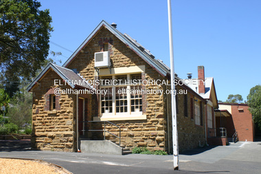
Photograph - Digital Photograph, Alan King, Original Kangaroo Ground Primary School No. 2105 building, Eltham-Yarra Glen Road, Kangaroo Ground, 28 December 2007
Kangaroo Ground's first school began in 1851 with 22 pupils from the district's ten families. It was a single room school located further south on the site, which also served as a Presbyterian church. The first teacher was Andrew Ross. The school building was used as a Post Office between 1854 and 1858 and during 1857 also served as a Court of Petty Sessions. With a growing farming community, a new building was warranted and the original Sate School No. 352 was closed and a new building, State School No. 2105 was oipened October 1, 1878. A residence for Head Teacher Henry Wallace School was erected in 1879 attached to the left of the school building. That residence is now home to the Andrew Ross Museum, which opened in 1993. Covered under Heritage Overlay, Nillumbik Planning Scheme. Published: Nillumbik Now and Then / Marguerite Marshall 2008; photographs Alan King with Marguerite Marshall.; p35This collection of almost 130 photos about places and people within the Shire of Nillumbik, an urban and rural municipality in Melbourne's north, contributes to an understanding of the history of the Shire. Published in 2008 immediately prior to the Black Saturday bushfires of February 7, 2009, it documents sites that were impacted, and in some cases destroyed by the fires. It includes photographs taken especially for the publication, creating a unique time capsule representing the Shire in the early 21st century. It remains the most recent comprehenesive publication devoted to the Shire's history connecting local residents to the past. nillumbik now and then (marshall-king) collection, kangaroo ground, andrew ross museum, eltham-yarra glen road, kangaroo ground primary school no. 2105, kangaroo ground state school, state school no. 2105 -
 Eltham District Historical Society Inc
Photograph - Digital Photograph, Alan King, Original Kangaroo Ground Primary School No. 2105 building, Eltham-Yarra Glen Road, Kangaroo Ground, 28 December 2007
Kangaroo Ground's first school began in 1851 with 22 pupils from the district's ten families. It was a single room school located further south on the site, which also served as a Presbyterian church. The first teacher was Andrew Ross. The school building was used as a Post Office between 1854 and 1858 and during 1857 also served as a Court of Petty Sessions. With a growing farming community, a new building was warranted and the original Sate School No. 352 was closed and a new building, State School No. 2105 was oipened October 1, 1878. A residence for Head Teacher Henry Wallace School was erected in 1879 attached to the left of the school building. That residence is now home to the Andrew Ross Museum, which opened in 1993. Covered under Heritage Overlay, Nillumbik Planning Scheme. Published: Nillumbik Now and Then / Marguerite Marshall 2008; photographs Alan King with Marguerite Marshall.; p35This collection of almost 130 photos about places and people within the Shire of Nillumbik, an urban and rural municipality in Melbourne's north, contributes to an understanding of the history of the Shire. Published in 2008 immediately prior to the Black Saturday bushfires of February 7, 2009, it documents sites that were impacted, and in some cases destroyed by the fires. It includes photographs taken especially for the publication, creating a unique time capsule representing the Shire in the early 21st century. It remains the most recent comprehenesive publication devoted to the Shire's history connecting local residents to the past. nillumbik now and then (marshall-king) collection, kangaroo ground, eltham-yarra glen road, kangaroo ground primary school no. 2105, kangaroo ground state school, state school no. 2105 -
 Eltham District Historical Society Inc
Photograph - Digital Photograph, Alan King, Cameron family graves, Kangaroo Ground Cemetery, Eltham-Yarra Glen Road, Kangaroo Ground, 28 January 2008
Six year old Judith Furphy was the first person known to have been buried at Kangaroo Ground Cemetery in May 1851. The cemetery is situated on an ancient river bed with exposed Nillumbik sands. The rest of the district is formed from black volcanic soil which was hard to dig. According to local historian Mick Woiwod (deceased) the site may have been a burial ground for the local Wurundjeri people as the exposed softer sands were always their prefered camping sites. The Hon. Ewen Hugh Cameron who lived at Pigeon Bank and was the Member for Evelyn for 40 years (1874-1914) was buried here in 1915. Published: Nillumbik Now and Then / Marguerite Marshall 2008; photographs Alan King with Marguerite Marshall.; p39This collection of almost 130 photos about places and people within the Shire of Nillumbik, an urban and rural municipality in Melbourne's north, contributes to an understanding of the history of the Shire. Published in 2008 immediately prior to the Black Saturday bushfires of February 7, 2009, it documents sites that were impacted, and in some cases destroyed by the fires. It includes photographs taken especially for the publication, creating a unique time capsule representing the Shire in the early 21st century. It remains the most recent comprehenesive publication devoted to the Shire's history connecting local residents to the past. nillumbik now and then (marshall-king) collection, kangaroo ground, eltham-yarra glen road, agnes bell cameron, agnes cameron (nee bell), cameron family, edward aubrey haughton, eugene cameron, evelyn florence cameron, ewen hugh cameron, gravestones, jane armstrong, jane bell, jessie agnes haughton (nee cameron), jessie cameron, john donald cameron, kangaroo ground cemetery, neville cameron, simon armstrong, vera cameron, william bell armstrong, wurundjeri -
 Eltham District Historical Society Inc
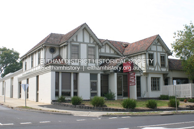
Photograph - Digital Photograph, Alan King, Eltham Hotel, cnr Main Road and Pitt Street, 28 December 2007
The Eltham Hotel is the oldest continually operating hotel in the Eltham district. Initially referred to as the Little Eltham Hotel, it has been known as the Eltham Hotel since the mid-1850s through to the present except for a brief period as the Eltham Tavern in the late 1980s. The original hotel opened in 1854 by Richard Warren was built by Benjamin Oliver Wallis. The Fountain of Friendship Hotel on the opposite side of Maria Street (Main Road) opened shortly after. The hotel was a well-known resting place for gold diggers during the gold rush at Woods’ Point and Warren would buy the gold from the diggers. Warren ran into financial difficulties and determined to return to England. Wallis bought the hotel in 1861 and ran it till 1886 when he sold it to Christopher Watson Snr. When Christopher Watson Snr died a year after purchase, his son Christopher took over until his death in 1909 when it passed to wife Emily and then their youngest son, Herbert James (Jim) Watson in 1915. In July 1925, Jim Watson demolished the original building and, in its place, erected a modern hotel which remains the foundation of the present-day Eltham Hotel. Covered under Heritage Overlay, Nillumbik Planning Scheme. Published: Nillumbik Now and Then / Marguerite Marshall 2008; photographs Alan King with Marguerite Marshall.; p41This collection of almost 130 photos about places and people within the Shire of Nillumbik, an urban and rural municipality in Melbourne's north, contributes to an understanding of the history of the Shire. Published in 2008 immediately prior to the Black Saturday bushfires of February 7, 2009, it documents sites that were impacted, and in some cases destroyed by the fires. It includes photographs taken especially for the publication, creating a unique time capsule representing the Shire in the early 21st century. It remains the most recent comprehenesive publication devoted to the Shire's history connecting local residents to the past. nillumbik now and then (marshall-king) collection, eltham, eltham hotel, main road, pitt street -
 Eltham District Historical Society Inc
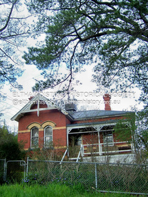
Photograph - Digital Photograph, Alan King, Jarrold Cottage, 701 Main Road, Eltham, 29 January 2008
Jarrold Cottage or White Cloud is known by many to be associated with the Skipper family, and has been since 1944 when Lena Skipper, wife of Mervyn Skipper purchased the cottage. She purchased it from the Estate of Thekla Jarrold who had died in March of the previous year. By the time Thekla died, she had lived in the Jarrold Cottage for 50 years. Thekla Alvenia Sissilia Ellian married John William Jarrold in 1888 at Clifton Hill. They started their family there but when John’s father William (who was married to Hannah Coleman) died in 1893 the family moved to Eltham. William had married Hannah Coleman in 1856 at his home in Eltham. William had arrived in the colony in 1848 so it is believed the Jarrold Cottage goes back at least to 1856 and possibly early 1850s. For a short period of time the cottage was rented to the Police as a temporary Police Station whilst a new and more permanent station was built further up the hill in 1859. The cottage was originally located closer to the Diamond Creek but was subject to flooding so was relocated to its present position on top a mound of rubble placed there from the nearby quarry next to the Dalton Street school (on Main Road). By 1916, John Henry Clark, a photographer who took many early photos of Eltham relocated from Fitzroy to Eltham and boarded with recently widowed Thekla Jarrold and her family. He changed professions from photographer to boot and harness maker around 1931 and Thekla had a small bootmakers shop built ifor him in the corner of her property next to the family home. J.H. Clark remained living at the property until his death in December 1956. At some stage after Clark's death, Lena Skipper is recorded living at the property having relocated from Montsalvat following the death of her husband Mervyn. The property continues to remain within the Skipper family as of 2023. Covered under Heritage Overlay, Nillumbik Planning Scheme. Published: Nillumbik Now and Then / Marguerite Marshall 2008; photographs Alan King with Marguerite Marshall.; p47This collection of almost 130 photos about places and people within the Shire of Nillumbik, an urban and rural municipality in Melbourne's north, contributes to an understanding of the history of the Shire. Published in 2008 immediately prior to the Black Saturday bushfires of February 7, 2009, it documents sites that were impacted, and in some cases destroyed by the fires. It includes photographs taken especially for the publication, creating a unique time capsule representing the Shire in the early 21st century. It remains the most recent comprehenesive publication devoted to the Shire's history connecting local residents to the past. nillumbik now and then (marshall-king) collection, bootmaker's shop, hannah coleman, jarrold cottage, john henry clark, john william jarrold, lena skipper, police station, thekla alvenia sissilia jarrold (nee ellian), white cloud cottage, william jarrold -
 Eltham District Historical Society Inc
Photograph - Digital Photograph, Alan King, Former bootmaker's shop, Main Road Eltham, 29 January 2008
The former bootmaker's shop is one of only three remaining original shops from the early 20th century in what was once Little Eltham, the others being the present day Cafe Zen-Den at 736 Main Road and the former Burgoyne General Store and Post Office, present-day San Antonio Barbershop at 820 Main Road. Jarrold Cottage or White Cloud is known by many to be associated with the Skipper family, and has been since 1944 when Lena Skipper, wife of Mervyn Skipper purchased the cottage. She purchased it from the Estate of Thekla Jarrold who had died in March of the previous year. By the time Thekla died, she had lived in the Jarrold Cottage for 50 years. Thekla Alvenia Sissilia Ellian married John William Jarrold in 1888 at Clifton Hill. They started their family there but when John’s father William (who was married to Hannah Coleman) died in 1893 the family moved to Eltham. William had married Hannah Coleman in 1856 at his home in Eltham. William had arrived in the colony in 1848 so it is believed the Jarrold Cottage goes back at least to 1856 and possibly early 1850s. For a short period of time the cottage was rented to the Police as a temporary Police Station whilst a new and more permanent station was built further up the hill in 1859. The cottage was originally located closer to the Diamond Creek but was subject to flooding so was relocated to its present position on top a mound of rubble placed there from the nearby quarry next to the Dalton Street school (on Main Road). By 1916, John Henry Clark, a photographer who took many early photos of Eltham relocated from Fitzroy to Eltham and boarded with recently widowed Thekla Jarrold and her family. He changed professions from photographer to boot and harness maker around 1931 and Thekla had a small bootmakers shop built ifor him in the corner of her property next to the family home. J.H. Clark remained living at the property until his death in December 1956. At some stage after Clark's death, Lena Skipper is recorded living at the property having relocated from Montsalvat following the death of her husband Mervyn. The property continues to remain within the Skipper family as of 2023. Covered under Heritage Overlay, Nillumbik Planning Scheme. Published: Nillumbik Now and Then / Marguerite Marshall 2008; photographs Alan King with Marguerite Marshall.; p47This collection of almost 130 photos about places and people within the Shire of Nillumbik, an urban and rural municipality in Melbourne's north, contributes to an understanding of the history of the Shire. Published in 2008 immediately prior to the Black Saturday bushfires of February 7, 2009, it documents sites that were impacted, and in some cases destroyed by the fires. It includes photographs taken especially for the publication, creating a unique time capsule representing the Shire in the early 21st century. It remains the most recent comprehenesive publication devoted to the Shire's history connecting local residents to the past. nillumbik now and then (marshall-king) collection, bootmaker's shop, jarrold cottage, john henry clark, lena skipper, thekla alvenia sissilia jarrold (nee ellian), white cloud cottage, shops -
 Eltham District Historical Society Inc
Photograph - Digital Photograph, Alan King, Eltham Primary School No. 209, Dalton Street, Eltham, 28 December 2007
This building is the earliest building remaining on site today. It was built in 1875 and was the second school building replacing the original 1856 building of stone walls with wooden shingles on the roof. That building needed to be replaced after the stone walls collapsed outwards. In August 1912 the school issued a requisition for remodelling of the school concerned with replacement of the existing windows with larger and wider windows to allow additional light into the school rooms and the erection of a wooden partition in the centre of the room. An extension to the building at rear and skylights in the roof were added in 1921. Only two low wooden stairs were originally provided to enter the porch. These were rebuilt by 1928. A steel mud grate was introduced 1930s/1940s and an infant shelter shed circa 1945. Covered under Heritage Overlay, Nillumbik Planning Scheme. Published: Nillumbik Now and Then / Marguerite Marshall 2008; photographs Alan King with Marguerite Marshall.; p49This collection of almost 130 photos about places and people within the Shire of Nillumbik, an urban and rural municipality in Melbourne's north, contributes to an understanding of the history of the Shire. Published in 2008 immediately prior to the Black Saturday bushfires of February 7, 2009, it documents sites that were impacted, and in some cases destroyed by the fires. It includes photographs taken especially for the publication, creating a unique time capsule representing the Shire in the early 21st century. It remains the most recent comprehenesive publication devoted to the Shire's history connecting local residents to the past. nillumbik now and then (marshall-king) collection, dalton street, eltham primary school, state school no. 209 -
 Eltham District Historical Society Inc
Photograph - Digital Photograph, Marguerite Marshall, Former Head Teacher's residence, Eltham Primary School, Dalton Street, Eltham, 7 September 2008
Built in 1891 for Head Teacher John Brown. His predecessor and the school's first Head Teacher, John Clark, lived in his own house 'Shoestring' in Metery Road, adjacent to the school. At the time of this photograph, the building was being used for before and after school care. Its present-day (2023) use is for school administration offices. Covered under Heritage Overlay, Nillumbik Planning Scheme. Published: Nillumbik Now and Then / Marguerite Marshall 2008; photographs Alan King with Marguerite Marshall.; p49This collection of almost 130 photos about places and people within the Shire of Nillumbik, an urban and rural municipality in Melbourne's north, contributes to an understanding of the history of the Shire. Published in 2008 immediately prior to the Black Saturday bushfires of February 7, 2009, it documents sites that were impacted, and in some cases destroyed by the fires. It includes photographs taken especially for the publication, creating a unique time capsule representing the Shire in the early 21st century. It remains the most recent comprehenesive publication devoted to the Shire's history connecting local residents to the past. nillumbik now and then (marshall-king) collection, dalton street, eltham, eltham primary school, headmaster's residence, main road, state school no. 209 -
 Eltham District Historical Society Inc
Photograph - Digital Photograph, Marguerite Marshall, Souter House, 23 Falkiner Street, Eltham, 20 June 2008
Originally built in the 1850s by Charles Souter from earth excavated from his property. It was a forerunner for a building style that was later to be synonymous with Eltham. The house is historically significant as the oldest mud brick building in the Shire of Nillumbik, as one of less than half a dozen buildings from the 1850s that survive in the Shire. It underwent several additions and alterations between c.1950s-1980s. It is also significant for its associations with Mervyn Skipper from the well-known Eltham family who was one of the founders of the artist's colony at Montsalvat. The house is architecturally significant because its north section was designed by the noted 'Eltham-style' architect, Alistair Knox, and the two long Oregon beams supporting the main floor were added by the noted 'Eltham-style' builder, Horrie Judd who built the southern room. A onetime tenant in the house, Judd built many Eltham houses and was a major builder of Montsalvat. The 1934 flood destroyed the south wall and the house remained unoccupied for some time. Sonia Skipper, one of Montsalvat’s builders who also worked for Alistair Knox oversaw rebuilding it. She employed landscape designer Gordon Ford, artist Peter Glass and Tim Burstall. The house originally had a cellar for making and storing wine, reputedly the first made in the district according to Alistair Knox in his book ‘We are what we stand on’ (p33). Water would seep into the cellar so Sonia’s father and then owner of the house, Mervyn Skipper bulldozed a channel outside to divert it. The Brocksopp family purchased the house in 1950 and added an outside door to the cellar and converted it into a gallery. Covered under Heritage Overlay, Nillumbik Planning Scheme. Published: Nillumbik Now and Then / Marguerite Marshall 2008; photographs Alan King with Marguerite Marshall.; p51This collection of almost 130 photos about places and people within the Shire of Nillumbik, an urban and rural municipality in Melbourne's north, contributes to an understanding of the history of the Shire. Published in 2008 immediately prior to the Black Saturday bushfires of February 7, 2009, it documents sites that were impacted, and in some cases destroyed by the fires. It includes photographs taken especially for the publication, creating a unique time capsule representing the Shire in the early 21st century. It remains the most recent comprehenesive publication devoted to the Shire's history connecting local residents to the past. nillumbik now and then (marshall-king) collection, eltham, falkiner street, mud brick building, mudbrick houses, souter house -
 Eltham District Historical Society Inc
Photograph - Digital Photograph, Marguerite Marshall, One Tree Hill Mine, Smiths Gully, 8 June 2006
Gold was discovered on One Tree Hill in 1854. The site has been worked intermittently until fairly recent times. Published: Nillumbik Now and Then / Marguerite Marshall 2008; photographs Alan King with Marguerite Marshall.; p53This collection of almost 130 photos about places and people within the Shire of Nillumbik, an urban and rural municipality in Melbourne's north, contributes to an understanding of the history of the Shire. Published in 2008 immediately prior to the Black Saturday bushfires of February 7, 2009, it documents sites that were impacted, and in some cases destroyed by the fires. It includes photographs taken especially for the publication, creating a unique time capsule representing the Shire in the early 21st century. It remains the most recent comprehenesive publication devoted to the Shire's history connecting local residents to the past. nillumbik now and then (marshall-king) collection, gold mining, one tree hill mine, smiths gully -
 Eltham District Historical Society Inc
Photograph - Digital Photograph, Alan King, Graves of Thomas Sweeney and family, Eltham Cemetery, Victoria, 27 January 2008
The grave of Thomas Sweeney, former convict turned respectable citizen. The Murray and Sweeney families were both early settlers of the Eltham district and connected by marriage. Their family plots are located side by side in the Catholic section of the Eltham Cemetery. Irish-born Thomas Sweeney is regarded as the first settler in Eltham. He was transported to Sydney in 1823 after being convicted of arson. He was granted his freedom in 1838 and married Margaret Meehan in the same year. They moved to Melbourne and in 1842 Thomas purchased 110 acres beside the Yarra River in the vicinity of present-day Sweeneys Lane. He called the property ‘Culla Hill’ and built a small slab hut (reputedly with Wurundjeri help; Margaret is said to have run an informal hospital for them in return). This was followed in 1846 by more substantial buildings consisting of a three-roomed Irish-style ‘longhouse’ and a barn made of stone and handmade bricks, with doors large enough to accommodate a fully loaded wagon. When the gold rush came, Thomas prospered by selling meat and potatoes to the prospectors, enabling him to purchase a further 308 acres in 1856. He promoted the construction of a bridge over the Plenty River and the establishment of a school at Eltham. Roman Catholic Church services were held at Culla Hill in the early years. When he died in 1867, he was regarded as a respected member of the community. Thomas and Margaret are buried in Eltham Cemetery with many of their descendants. Their first son John continued to farm Culla Hill until his death in 1909. Culla Hill passed out of the Sweeneys' possession in 1939. The house and barn remain today, though lesser outbuildings have gone. The facade of the house is much the same as it was in the 1840s. Sacred To the memory of Thomas Sweeney Who died Sep 6th 1867 Aged 65 years May his soul res in peace Also his wife Margaret Died Oct 3rd 1884 aged 73 years And their daughters Annie Died Aug 22nd 1860 aged 21 years Johanna Died Aug 19th 1872 aged 22 years Margaret Died 7th Sep 1913 aged 72 years R.I.P. Also In Memory Of John Sweeney Died 24th May 1909 Aged 65 years Also of his wife Ellen Died 8th March 1910 Aged 64 years R.I.P Also In Memory Of Caroline Infant daughter of John & Ellen Sweeney Published: Nillumbik Now and Then / Marguerite Marshall 2008; photographs Alan King with Marguerite Marshall.; p55This collection of almost 130 photos about places and people within the Shire of Nillumbik, an urban and rural municipality in Melbourne's north, contributes to an understanding of the history of the Shire. Published in 2008 immediately prior to the Black Saturday bushfires of February 7, 2009, it documents sites that were impacted, and in some cases destroyed by the fires. It includes photographs taken especially for the publication, creating a unique time capsule representing the Shire in the early 21st century. It remains the most recent comprehenesive publication devoted to the Shire's history connecting local residents to the past. nillumbik now and then (marshall-king) collection, annie sweeney, caroline sweeney, ellen sweeney, eltham cemetery, graves, gravestones, johanna sweeney, john murray, john sweeney, margaret sweeney, mary ellen drain, mary murray, thomas murray, thomas sweeney -
 Eltham District Historical Society Inc
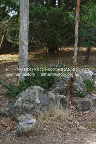
Photograph - Digital Photograph, Alan King, Grave of Gordon Ford, Eltham Cemetery, Victoria, 27 January 2008
Gordon Ford was a conservationist and a pioneer of natural-style landscaping. He came to Eltham in 1948 and bought a block of land in John Street extending through to Pitt Street. Artist Peter Glass lived opposite in John Street. Early on, Gordon worked for Alistair Knox on construction of the mudbrick Busst house amongst others. At the same time, with the help of friends including artist Clifton Pugh, he progressively built his own house ‘Fülling’, which "grew like Topsy" utilising a variety of second-hand materials. His main focus, which became his life-long occupation, was garden landscaping. Inspired by Edna Walling and Ellis Stones, he sought to reflect the bush settings of rural Victoria where he had grown up. Commissions included Monash University and countless industrial sites but designing for the archetypal quarter-acre block gave him the most satisfaction. He had a huge impact on the look of gardens in Australia from the 1950s, creating seemingly natural bush environments by carefully integrating indigenous and exotic plantings. Gordon died in 1999 and is buried in Eltham Cemetery; the gravesite in a natural landscape setting is marked by a plaque. Another plaque (away from his grave) notes his landscaping design work within the cemetery grounds and at Alistair Knox Park. Gordon Craig Ford 30-8-1918 - 16-6-1999 Landscape designer Loved and respected Husband of Gwen, father Of Angela, Emma, Ben, Cassie, Dailan, Caitlin. A good life lived well Published: Nillumbik Now and Then / Marguerite Marshall 2008; photographs Alan King with Marguerite Marshall.; p55This collection of almost 130 photos about places and people within the Shire of Nillumbik, an urban and rural municipality in Melbourne's north, contributes to an understanding of the history of the Shire. Published in 2008 immediately prior to the Black Saturday bushfires of February 7, 2009, it documents sites that were impacted, and in some cases destroyed by the fires. It includes photographs taken especially for the publication, creating a unique time capsule representing the Shire in the early 21st century. It remains the most recent comprehenesive publication devoted to the Shire's history connecting local residents to the past. nillumbik now and then (marshall-king) collection, graves, eltham cemetery, gordon craig ford, gravestones, gwen ford, memorials -
 Eltham District Historical Society Inc
Photograph - Digital Photograph, Marguerite Marshall, Wingrove Cottage, Main Road, Eltham, 8 June 2006
Wingrove Cottage built 1858-1859 of hand made bricks is historically significant for its long association with Charles Wingrove, a prominent figure in Victorian local government, as secretary to the Eltham District Road Board and Shire Council from 1858 to 1904, and Shire Engineer and Secretary to the Heidelberg Road Board. The cottage was used as the office of the Eltham District Road Board and Council for many years It is one of the Shire's oldest dwellings, and one of the few surviving 19th century buildings associated with early Eltham and located in the original Eltham Village Reserve. The symmetrical planting of a pair of Pencil Pines (not visible in photo) is also historically and aesthetically significant as characteristic of the early period of planting in the district and because they are a distinctive landscape feature. In October 2002 new owners demolished the outbuildings attached to the rear of the cottage. Community protest at the demolition resulted in Council issuing a Stop Work order. The owner was issued with a court order in September 2003 to develop a conservation management plan and restore the heritage listed property. The owner sold the property in 2005 to Cameron Construction in 2005 who undertook the restoration work. In 2007 a planning application to build two offices and seven dwellings at the rear of the property was ultimately rejected. The cottage is now the main office for Cameron Construction. Covered under Heritage Overlay, Nillumbik Planning Scheme. Published: Nillumbik Now and Then / Marguerite Marshall 2008; photographs Alan King with Marguerite Marshall.; p57This collection of almost 130 photos about places and people within the Shire of Nillumbik, an urban and rural municipality in Melbourne's north, contributes to an understanding of the history of the Shire. Published in 2008 immediately prior to the Black Saturday bushfires of February 7, 2009, it documents sites that were impacted, and in some cases destroyed by the fires. It includes photographs taken especially for the publication, creating a unique time capsule representing the Shire in the early 21st century. It remains the most recent comprehenesive publication devoted to the Shire's history connecting local residents to the past. nillumbik now and then (marshall-king) collection, cameron construction, charles symons wingrove, eltham, eltham road district board, eltham shire council, main road, wingrove cottage -
 Eltham District Historical Society Inc
Photograph - Digital Photograph, Alan King, Eltham Living and Learning Centre, 26 January 2008
In 1857, tanner John Pearson purchased three and a half acres of land in Little Eltham, at the western end of Pitt Street, with a 70-foot frontage to Maria Street (Main Road) and stretching down to the Diamond Creek for £100. He contracted Benjamin Oliver Wallis to build house for him. Wallis, a mason by trade who originated from the Cornish village of Newlyn, migrated to Melbourne in 1853 and was shortly engaged by Richard Warren to build the Eltham Hotel, which opened in 1854. When Warren fell into financial difficulty in 1858, Wallis purchased the hotel. That same year, Pearson constructed a tannery below the house with access to the water in the Diamond Creek. When Pearson became bankrupt in 1867, Wallis similarly acquired the house from Pearson’s creditors in 1868 and lived there until his death in 1896. For some of this time the house was in the name of Wallis’s son Richard but following his death in 1888, ownership reverted to his father. It was purchased by retired teacher Richard Gilsenen in 1899. Gilsenen was made acting head teacher at the Eltham State School in 1906 following the sudden death of head teacher John Brown. In the 1950s the house was bought by retired engineer Dr Alfred Fitzpatrick and his wife Claire who made various modifications to house goats and poultry as well as structural modifications to the house. In the early 1970s, Eltham Shire Councillors Frank Maas and Don Maling proposed an extended communities’ activities program be set up and the Commonwealth Grants Commission was approached for financial assistance. In 1974 a $50,000 Commonwealth Grant was received by the Shire Council to acquire the Fitzpatrick property as part of the planning to establish an extended communities’ activities program. The Fitzpatricks moved next door and Claire taught at the new Living and Learning Centre, which began in 1975, one of the first community education centres in Victoria. Covered under Heritage Overlay, Nillumbik Planning Scheme. Published: Nillumbik Now and Then / Marguerite Marshall 2008; photographs Alan King with Marguerite Marshall.; p59This collection of almost 130 photos about places and people within the Shire of Nillumbik, an urban and rural municipality in Melbourne's north, contributes to an understanding of the history of the Shire. Published in 2008 immediately prior to the Black Saturday bushfires of February 7, 2009, it documents sites that were impacted, and in some cases destroyed by the fires. It includes photographs taken especially for the publication, creating a unique time capsule representing the Shire in the early 21st century. It remains the most recent comprehenesive publication devoted to the Shire's history connecting local residents to the past. nillumbik now and then (marshall-king) collection, benjamin oliver wallis, claire fitzpatrick, don maling, dr alfred fitzpatrick, eltham living and learning centre, frank maas, john pearson, richard gilsenen, tannery -
 Eltham District Historical Society Inc
Booklet - Folder, 2020 Vision: a preferred future, 1984
Following council amalgamations, a series of community consultations were undertaken in 1995 to inform the development of a cohesive vision for the newly formed Shire of Nillumbik. A response to the new conditions which people of the Eltham/Diamond Creek/Greensborough and surrounding rural areas found themselves in as a result of the decision by the Victorian Government to amalgamate local governments into larger entities. The case for these reforms was strong, but the amalgamation process did disrupt some people's lives.The need to bring together the people within the new boundaries of Nillumbik was recognised by the Commissioners and the Chief Executive Officer of the Shire, who felt that a good way to begin was to develop a future vision for the Shire. It was decided that the people of the Shire should be asked what they wanted their future to be and a process of consultation was established through which people could express their views. Contents: Part One: Introduction, Nillumbik 1995 -what we thought, Nillumbik - thinking the future, Creatng a Nillumbik Community, Nillumbik's assets, Goals for Nillumbik 2020. Part Two: A sustainable society, population and density, the built environment, town and community centres, transport, agriculture, rural Nillumbik, Arts and cultural activity, the younger generation, Nillumbik's elders, planning for the disabled and health and well-being.40 pagesharry gilham collection, shire of nillumbik, vision, consultation, planning -
 Wodonga & District Historical Society Inc
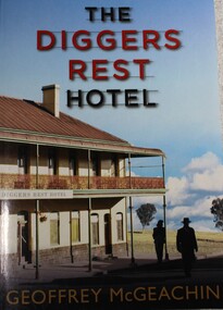
Book - The Diggers Rest Hotel: A Charlie Berlin Mystery, Geoffrey McGeachin, 31st May 2010
A mystery novel set in Wodonga, Victoria after World War 2. In 1947, two years after witnessing the death of a young Jewish woman in Poland, Charlie Berlin has rejoined the police force a different man. Sent to investigate a spate of robberies in rural Victoria, he soon discovers that World War II has changed even the most ordinary of places and people. Taking a room at the Diggers Rest Hotel in Wodonga, he sets about solving a case that no one else can – with the help of feisty, ambitious journalist Rebecca Green and rookie constable Rob Roberts, the only cop in town he can trust.fictionA mystery novel set in Wodonga, Victoria after World War 2. In 1947, two years after witnessing the death of a young Jewish woman in Poland, Charlie Berlin has rejoined the police force a different man. Sent to investigate a spate of robberies in rural Victoria, he soon discovers that World War II has changed even the most ordinary of places and people. Taking a room at the Diggers Rest Hotel in Wodonga, he sets about solving a case that no one else can – with the help of feisty, ambitious journalist Rebecca Green and rookie constable Rob Roberts, the only cop in town he can trust.mystery fiction, wodonga post world war 2 -
 Wooragee Landcare Group
Photograph, 3rd April 2004
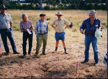
This photograph depicts fox behaviour specialist Camille Veselsky demonstrating the use of a fox bait trap at an event conducted as part of an awareness campaign highlighting damage done to farm and domestic animals and native wildlife in April 2004. Camille Veselsky is a specialist in fox behaviour who worked for the Hume Rural lands Protection Board on pest animal control for 27 years. This date is suggested by the photograph's position in the 2004-2005 Wooragee Landcare Group Coordinator's Report folder. A note accompanying the item suggests an alternative date of February 2004, however. This event raised awareness about the impacts of foxes in rural areas and provided practical training in techniques to control their populations. Flyers contained in the parent folder suggest that baiting may have been agreed as a method of fox control as the event depicted was followed by a two week baiting campaign a fortnight later. Pictured in the photograph are Helmut Wiemann, Ursula Wiemann, Camille Veselsky and two other people (unknown). A note accompanying the items suggests the photograph may have been entered by Karen Bowley or Maree Missen. In the folder, an printed label accompanying the photograph states: 'A marker to identify the bait station will not deter the fox.' Regional areas like Wooragee are susceptible to fox attacks due to the availability of food such as rubbish, scraps, native wildlife and livestock. Foxes can have a huge impact on native wildlife and domestic life as they are known to chew through irrigation systems, dig-up and defecate in gardens, raid rubbish bins and harass other domestic animals. Ground-dwelling native species are particularly susceptible to predation by foxes, which when combined with loss of habitat can endanger these species. Affected species include Speckled Warblers, Plovers, Diamond Firetails, Spotted Quail-Thrushes, Turquoise Parrots, Dunnarts, Bandicoots, Phascogales, skinks, geckos and legless lizards. This photograph is significant as an example of awareness raising and threat control programs undertaken by Wooragee Landcare Group in the 2000s in Indigo Shire.Landscape coloured photograph printed on gloss paper. Reverse: 26 / [HANDWRITTEN] WAN NA 0ANA2N0 0 8743 / [PRINTED] (No. 14) / 260 / wooragee, wooragee landcare, indigo shire, north-east victoria, conservation, pest control, fox, foxes, vermin, baiting, trapping, camille veselsky, hume rural lands protection board, 2004, speckled warbler, plovers, diamond firetails, turquoise parrots, dunnarts, bandicoots, phascogales, skinks, geckos, legless lizards, chickens, ducks, guinea-pigs -
 Wooragee Landcare Group
Photograph, 3rd April 2004
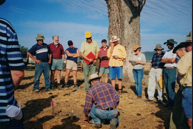
This photograph depicts fox behaviour specialist Camille Veselsky demonstrating the use of a fox bait trap at an event conducted as part of an awareness campaign highlighting damage done to farm and domestic animals and native wildlife in April 2004. Camille Veselsky is a specialist in fox behaviour who worked for the Hume Rural lands Protection Board on pest animal control for 27 years. This date is suggested by the photograph's position in the 2004-2005 Wooragee Landcare Group Coordinator's Report folder. A note accompanying the item suggests an alternative date of February 2004, however. This event raised awareness about the impacts of foxes in rural areas and provided practical training in techniques to control their populations. Flyers contained in the parent folder suggest that baiting may have been agreed as a method of fox control as the event depicted was followed by a two week baiting campaign a fortnight later. Pictured in the photograph, left to right: unknown, Quentin Mansfield; four unknown people; Mary Prowse; two unknown people; Helmut Wiemann; unknown person. In the folder, the photograph is accompanied by a printed label stating: 'Train foxes to take free feeds before using the 1080. Small traces of fish oil can help attract foxes to the bait station.' Regional areas like Wooragee are susceptible to fox attacks due to the availability of food such as rubbish, scraps, native wildlife and livestock. Foxes can have a huge impact on native wildlife and domestic life as they are known to chew through irrigation systems, dig-up and defecate in gardens, raid rubbish bins and harass other domestic animals. Ground-dwelling native species are particularly susceptible to predation by foxes, which when combined with loss of habitat can endanger these species. Affected species include Speckled Warblers, Plovers, Diamond Firetails, Spotted Quail-Thrushes, Turquoise Parrots, Dunnarts, Bandicoots, Phascogales, skinks, geckos and legless lizards. This photograph is significant as an example of awareness raising and threat control programs undertaken by Wooragee Landcare Group in the 2000s in Indigo Shire.Landscape coloured photograph printed on gloss paper. Reverse: 25 / 2 [HANDWRITTEN] WAN NA 0ANA2N0 NNN+ 1 8743 / [PRINTED] (No.12) / 258wooragee, wooragee landcare group, indigo shire, north-east victoria, fox, foxes, pest control, vermin, conservation, baiting, trapping, farming, wildlife, speckled warblers, plovers, diamond firetails, spotted quail-thrush, turquoise parrot, dunnarts, bandicoots, phascogales, skinks, geckos, legless lizards, camille veselsky -
 Wooragee Landcare Group
Photograph, 3rd April 2004
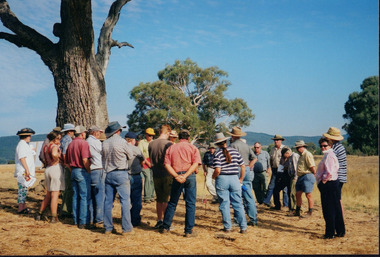
This photograph depicts people attending the 'Spotlight on Fox' event watching a demonstration. The event was conducted as part of an awareness campaign highlighting damage done to farm and domestic animals and native wildlife in April 2004. This date is suggested by the photograph's position in the 2004-2005 Wooragee Landcare Group Coordinator's Report folder. A note accompanying the item suggests an alternative date of February 2004, however. This event raised awareness about the impacts of foxes in rural areas and provided practical training in techniques to control their populations. Flyers contained in the parent folder suggest that baiting may have been agreed as a method of fox control as the event depicted was followed by a two week baiting campaign a fortnight later. Pictured in this photograph, left to right: unknown; Sue Berwick ; Jerry Alexander; rest unidentified. A note accompanying the items suggests the photograph may have been taken by Karen Bowley or Maree Missen. Regional areas like Wooragee are susceptible to fox attacks due to the availability of food such as rubbish, scraps, native wildlife and livestock. Foxes can have a huge impact on native wildlife and domestic life as they are known to chew through irrigation systems, dig-up and defecate in gardens, raid rubbish bins and harass other domestic animals. Ground-dwelling native species are particularly susceptible to predation by foxes, which when combined with loss of habitat can endanger these species. Affected species include Speckled Warblers, Plovers, Diamond Firetails, Spotted Quail-Thrushes, Turquoise Parrots, Dunnarts, Bandicoots, Phascogales, skinks, geckos and legless lizards. This photograph is significant as an example of awareness raising and threat control programs undertaken by Wooragee Landcare Group in the 2000s in Indigo Shire.Landscape coloured photograph printed on gloss paperReverse: WAN NA 0ANA2N0 NNN 0 8743 / [PRINTED] (No. 13) / 259wooragee, wooragee landcare, indigo shire, north-east victoria, foxes, fox, pest control, vermin, conservation, baiting, trapping, events, 2004, wildlife, speckled warbler, plovers, diamond firetails, spotted quail-thrush, turquoise parrots, dunnarts, bandicoots, phascogales, skinks, geckos, legless lizards, farming, chickens, ducks, guinea-pigs -
 Phillip Island Conservation Society Inc.
Work on paper - Photocopy of newspaper cutting, The Express, "SURFERS' FIRES KILL/ PENGUINS - FIREMEN//NOT US:/SURFERS"
Written during the 1960s when surfing was burgeoning across Australia’s coast and Phillip Island surf beaches had become extremely popular, few management strategies were in place to control interaction of the public with the delicate flora and fauna of the coastal environments. There were few good access tracks, car parks, bins, toilets etc at coastal/surfing hotspots around the Phillip Island coast. A number of management issues occurred with the influx of surfers. These included dune erosion caused by surfers climbing dunes to see the surf before going on the beach; informal parking on wildlife habitat; numerous access paths from wherever cars were parked down to the beach cutting through habitat; illegal camping on foreshores; illegal lighting of fires on beach and in dunes; surfers’ dogs let out of the car while surfers were out on the water. The dogs were uncontrolled. Certainly some surfers behaved responsibly, as is almost invariably the case these days. However, in that era of this article few people understood the delicate nature of the coastal environment and that it need to be protected through public education, infrastructure and enforcement of regulations. As now, most rural Fire services were run by dedicated volunteers who faced many challenges in their roles as Country Fire Authority firefighters. However, it was not uncommon for visitors and locals to also assist with fire-fighting efforts.The article is significant in containing quotes from both sides of the discussion who were directly involved in coastal fire incidents on Phillip Island in the 1960s. It also indicates the large number of surfers visiting Phillip Island beaches, the volunteer nature of the firefighting service and the extra challenges they faced on Phillip Island as a visitor destination. The anonymous university student surfer who is quoted, also describes possible causes of the fires, methods he and his fellow surfers used to extinguish the fires and raise the alarm, and the way they assisted the volunteer firefighters . The reference to him breaking into one of the Summerland housing estate holiday houses is also significant because that housing estate was purchased over 2 decades by successive Victorian governments to remove management issues caused to the wildlife habitat on Summerland Peninsula.Photocopy of newspaper cuttings including 2 related articles. Five columns of black text on white paper with one poorly reproduced photo bottom rightphillip island, cat bay, country fire authority, artie murdoch, alf towns, frank dixon, barry thompson, newhaven-san remo rural fire brigade, penguin parade, cowrie beach, surfers, coastal fires -
 Melton City Libraries
Document, Rural Fire Brigade's Group, c.1950
From the earliest days of settlement in the shire, residents demonstrated their willingness to band together in times of crisis and need. "Bushfires were always a terrifying prospect and since its establishment in 1935, the local fire brigade (later the Country Fire Authority) fought hard to protect the people, homes and animals of the shire. In 1966, the Mount Cottrell Fire Brigades Group was formed as a way of consolidating the smaller groups around Melton, Rockbank, Toolern Vale, Sydenham, Truganina and Werribee. Its headquarters were established at the home of Ernest ‘Bon’ and Edna Barrie in Ferris Road, Melton. Captain Bon Barrie was a member of the Melton Fire Brigade and elected group and communications officer of the new Mount Cottrell Brigades Group.22 Wendy Barrie, daughter of Edna and Bon, remembers the fire truck parked at their house and her mother operating the fire brigade’s radio. Growing up in the fire station headquarters, Wendy and her siblings learned how to use the radio too, in case of emergencies".Rural Fire Brigade's Group List of Authorised Officers including the captains and lieutenantsemergency services -
 Melton City Libraries
Card, Mount Cottrell Rural Fire Brigade Call Sign documents, Unknown
Communications (Telephone) Fire calls over a number years the following people monitored the Fire Call Jack and Lila Gilliland-Postmasters Vera Radford Ernie and Betty Abraham Ken and Lil YoungThese documents belonged to Melton Fire Brigadeemergency services, local identies -
 Melton City Libraries
Newspaper, Historic Homestead Vandalised, 1990
Edna Barrie describes the Darlingsford property. C.E. Barrrie Land developers bought the property from my husband’s brother. It was one big farm and they were a big family. When the father died he left it to be cut up for the family. The youngest son had to reach age 21 before the property could be divided and portioned out to the mother and children, but it was deferred until Jim returned from the war. Eventually it was cut up into two parts, we were married by then and so was Edgar. Part of the land included the block on the other side of Ferris road, which became the quarry, Edgar’s section was on the Toolern Creek end, he was the last one married and lived in the old bluestone house until 1974. The developers bought this section but they could not get permits due to the state of the old bridge due to the cost. Barries had built the bridge across the creek [1926]. It took the big loads of hay and the family kept it maintained. Once the Barries had gone it did not get any upkeep. The developers found the cost of replacing the bridge and developing site with sewerage and drainage power before they sell. The rural land itself is not worth much as the developer has to complete the subdivision before any blocks can be sold. The developer from Sydney had a man living in the house, who let it go the rack and ruin. He managed to buy from the developer 25 acres with the bluestone house. Bernard Coburn had it for a while but is was well out of our hands by then. There were various people who have bought into and tried to develop and have given up. There was a project sometime ago to save the buildings from ruin but nothing has happened as yet, they are six or seven years to late. The buildings continue to deteriorate and were badly damaged vandals and fire. The Shire bought all the rest of it from the developer, where the tip is now, that was also part of Edgars land. Article about a fire at Darlingsford Estate featured in the Telegraphlocal architecture, local identities, emergency services -
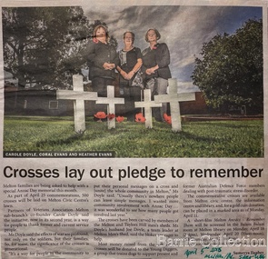 Melton City Libraries
Newspaper, Crosses lay out pledge to remember, 2015
"The outbreak of World War I in August 1914 had an immediate impact on communities across Australia, and it was no different in Melton. Young men began enlisting immediately, and Australia’s initial offer of 20,000 troops was soon exceeded by Victorian enlistments alone. Over the four years of the war, approximately 114,000 Victorians enlisted and around 91,000 servicemen and women were sent overseas. They came not just from Melbourne, but from all over the state; from farms, small towns and suburban areas. They included locals, newly arrived migrants and Indigenous people. The Australian home front was a hive of activity throughout the war, and the Melton community played its part. Following the announcement that Australia was joining the war with Great Britain and its allies on 5 August 1914, the Melton community lost no time in launching into action. A meeting ‘to assist the Red Cross fund’ was held in the Melton Mechanics’ Institute hall on 18 August – just days after the outbreak of the war. Collectors were appointed for each corner of the shire and individual donations were made. A Melton branch of the Australian Red Cross Society was formed in June 1915 and focused its energies on raising funds to purchase material that was used to make clothes for sick and wounded soldiers. A depot was established in Melton to collect clothing and other ‘comfort’ items for the soldiers – including reading material, tobacco, linen, canned foods and soap – and to coordinate the branch’s work and activities. Local cab driver Percival Stubbs volunteered to transport all the packages to the Melton railway station, until he enlisted and departed for the front in 1916. Such were the numbers of people getting involved that branches were also established in Toolern Vale and Rockbank. Regular community events were held to farewell soldiers who were leaving on active service and to welcome those who returned home. Gunner Robert (Bob) Wynne, whose uncle’s family ran the general store in Toolern Vale, was presented with a pair of field glasses (binoculars), a gold watch, inscribed locket and autographed letter by the Toolern Vale community before he set sail for the front in 1916. His mother noted that he ‘sailed away in good spirits with a smile till out of sight’. From June 1915 to June 1919, the Melton Red Cross branch donated 2,156 pairs of socks, 1,357 shirts, 425 kit bags, 251 pillowslips, 224 towels and 121 pairs of pajamas. Countless fundraising events were held, including jumble fairs, concerts and gift evenings. Local schools also encouraged students to contribute through fund-raising and making and collecting comforts for the soldiers. People across the country engaged in similar activities, but Victoria’s rural communities found unique ways of contributing. In Melton, people were encouraged to send rabbits and hares ‘in good condition’ to an exporter in Spencer Street, for export to Belgium ‘for the relief of those suffering". Special Anzac Memorial article featured in the Star Weeklylocal identities, war -
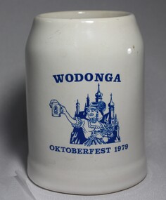 Wodonga & District Historical Society Inc
Memorabilia - Wodonga Oktoberfest Stein, c1979
Several German families arrived in Wodonga, usually via South Australia, in the late 1850 and 1860s. Some of the earliest settlers to arrive were the Haeusler, Schlink, Trudewind, Pfeiffer and Klinge families. Many of them had left from Prussia and Bavaria to escape religious persecution. They all became actively involved in the community and made outstanding and lasting contributions to the development of the town. In the years 1868-69 more settlers arrived from South Australia and other parts of Victoria. Among the names were Heckendorf, Mueller, Zeinert and Schubert. These families were instrumental in lobbying for the establishment of the St. John's Lutheran Church in Wodonga, the foundation stone being laid in 1874. By the 1890s to the early 1900s many other Germany names were added to the local community including Muller, Lange, Pumpa, Greschke, Lobbe, Posselt, Kreuger, Schuster, Pertzel, Star, Draper, Mueller, Semmler, Thiele, Terlich, Wegener, Schreiber and Draper. Germans continued to arrive in the area until 1914. In the great post-war migration that started through Bonegilla in December 1947, Germans were among the tens of thousands who arrived. Most of the migrants who settled in Wodonga at this time were born in Germany. According to the 2016 Census, Wodonga still has a larger percentage of people with German ancestry than most other rural communities in Victoria. The German Austrian Australian Club, Wodonga was originally formed in 1960 by immigrants to Australia, to provide a meeting place for refugees and immigrants from Europe. Oktoberfest has become a world-wide occasion for all people to share in the celebration of Bavarian traditions. The Wodonga Hospital approached the Club and asked for their involvement in holding an Oktoberfest to raise funds for the Hospital. These Fests took 11 months to organize and ended up raising over $27,000.00 for the Hospital. A large number of families of German origin have arrived in the Wodonga area from as early as the 1850s. They have made valuable and lasting contributions to the area in a range of fields including agriculture, local government, businesses, retail and medical services. Their contributions are recognised in several street names in Wodonga. A white china beer stein bearing the blue logo of the Wodonga 1979 Oktoberfest. Logo includes an image of a woman in German national costume.Above the image "WODONGA" Underneath the image "OKTOBERFEST 1979"wodonga, oktoberfest, german immigrants -
 Ballarat Heritage Services
Photograph - Photograph - Colour, Clare Gervasoni, Koroit Post Office, 2015, 21/12/2015
The town borrows its name from the Koroitch Gundidj people who occupied the area prior to European settlement. (https://en.wikipedia.org/wiki/Koroit, accessed 21 December 2016) Koroit was first surveyed as a township in 1847. Around the 1850 the district had the highest population of Irish immigrants in rural Australia. The Koroit Post Office was designed by architect and engineer John Mason of Port Fairy. (Moyne Shire Heritage Study 2006 Stage 2, Volume 2: Environmental History, Prepared for Moyne Shire Council Helen Doyle in association with Context Pty Ltd, 2006.) Rosebrook Bridge, Rosebrook (1853; replaced) Post Office buildings, Bank Street, Port Fairy (c.1857) The author Henry Handel Richardson lived in the Koroit Post Office as a child after her family moved to Koroit in 1878. Remembering Koroit from her youth, the third volume in her The Fortunes of Richard Mahony trilogy is set in the town. When the author was six, her father Walter died in Koroit on 1 August 1879 and was buried at the Koroit cemetery. (https://en.wikipedia.org/wiki/Koroit, accessed 21 December 2016) In 1878 Mary Richardson was appointed postmistress of the Koroit Post Office at a salary of 72 pounds with free quarters, firewood and kerosene. She lived at the back of the Post Office. (From a Green and Pleasant Land by H. McCorkell and P. Yule.) Photographs showing the bluestone Koroit Post Office, phone box and postbox. It is located at 99 Commercial Road, Koroit. "Historic Area Statement of Significance: The significance of Koroit derives from its role as the urban centre of one of the most concentrated Irish Roman Catholic rural districts in Australia, noted for its mixed livestock and cropping argicultural patterns. This is reflected in two separate and distinctive areas in the town - the administrative/commercial area and the church precinct. The administrative and commercial area (focussing on the Boundary-Commercial Road/High Street intersection and the Koroit Hotel) consists of a number of significant public buildings and leads to a street of relatively intact humble shopfronts and kerbline verandahs, visually punctuated by opposing bank facades. The church precinct is dominated by a group of Catholic buildings larger in scale and more complete in range than those in any comparably sized Victorian town." http://vhd.heritagecouncil.vic.gov.au/places/69338#sthash.ELLuSMvg.dpuf, accessed 21 December 2016."koroit, post office, phone box, payphone, bluestone, henry handel richardson, koroit post office -
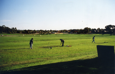 Whitehorse Historical Society Inc.
Photograph, Morack Golf Course, C1970
In 1970, the area now known as the Morack Golf Course was rezoned from 'Rural' to 'Public Open Space'. This allowed planning to go ahead and by 1973 sufficient land had been acquired by the Melbourne and Metropolitan Board of Works. The course was first open on 8 May 1976 as a nine-hole course. This was extended to 15 holes by January 1980, and to eighteen holes by 1981.Two coloured photographs a-b of the early days in the development of the Morack Golf Course. Overview of a hole plus white patches indicating where trees have been planted. Some people practicing.morack golf course -
 Ballarat Heritage Services
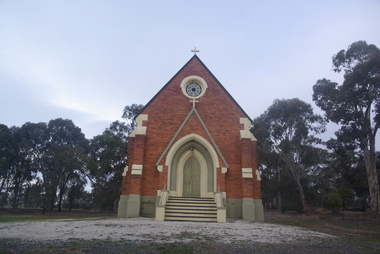
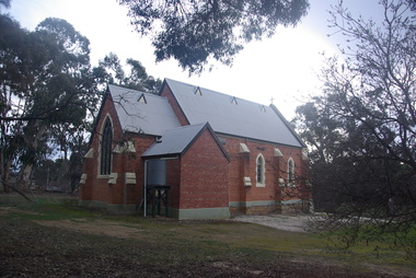
Photograph - Photograph - Colour, Lisa Gervasoni, St Laurence O'Toole Catholic Church, Sandon, 2017, 16/07/2017
St Laurence O'Toole church and cemetery is located in a rural setting at 801/821 Creswick-Newstead Rd, Sandon. Originally a small wooden school (22’x14’) was erected in Sandon by Father Patrick Smyth (who was involved in the Eureka Stockade movement) in 1859. It was also used for Mass and became known as a chapel. In June 1882 tenders were called for the construction of a brick Church by the Castlemaine architect, T.F. Kibble, and it was built at a cost of 1000 pounds. The church was blessed by Archbishop Goold on 06 May 1883 and dedicated to St Laurence O'Toole. The brick building demonstrates original design qualities of a Victorian Rudimentary Gothic style, including the steeply pitched, parapet gable roof form, together with a central steeply pitched, gabled porch that projects slightly from the main gable end. Other intact qualities include the exposed brick wall construction, lapped galvanised corrugated iron roof cladding, minor gabled porch at the rear, small ventilation dormers nearby the roof ridgeline, series of stone steps that lead to the central porch with its double pointed door opening and vertical boarded doors, simple rose window in the main gable end, pointed windows, brick buttresses with double lower copings, and the light masonry detailing (the banding marking the floor level within, buttress copings, window and door surrounds and quoins, and the drip moulds).(Shire of Mount Alexander: Heritage Study of the former Shire of Newstead, 2000) The visually connected cemetery demonstrates important visual qualities formed by the regular rows of graves and cemetery architecture, and the grassed and treed rural landscape. It is a rare and substantially intact example of a Victorian Catholic Church with a cemetery in its churchyard. Many headstones and cemetery architecture, date from the 19th century and represent some fine examples of masonry craftsmanship. Some refurbisments occurred during the 1940s and in 2002 a major restoration project was undertaken from roof to footings, by a dedicated band of volunteers and trades people. Work was completed mid 2003 and in November 2003 St Laurence’s was re-dedicated with the celebration of Mass and a picnic tea. Colour photograph of a brick church at Sandon, Victoria.sandon, sandon cemetery, st laurence o'toole catholic church, sandon -
 Ballarat Heritage Services
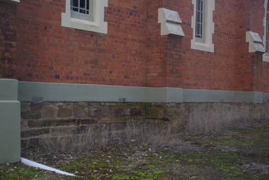
Photograph - Photograph - Colour, Clare Gervasoni, Sandstone foundations at St Laurence O'Toole Catholic Church, Sandon, 2017, 16/07/2017
St Laurence O'Toole church and cemetery is located in a rural setting at 801/821 Creswick-Newstead Rd, Sandon. Originally a small wooden school (22’x14’) was erected in Sandon by Father Patrick Smyth (who was involved in the Eureka Stockade movement) in 1859. It was also used for Mass and became known as a chapel. In June 1882 tenders were called for the construction of a brick Church by the Castlemaine architect, T.F. Kibble, and it was built at a cost of 1000 pounds. The church was blessed by Archbishop Goold on 06 May 1883 and dedicated to St Laurence O'Toole. The brick building demonstrates original design qualities of a Victorian Rudimentary Gothic style, including the steeply pitched, parapet gable roof form, together with a central steeply pitched, gabled porch that projects slightly from the main gable end. Other intact qualities include the exposed brick wall construction, lapped galvanised corrugated iron roof cladding, minor gabled porch at the rear, small ventilation dormers nearby the roof ridgeline, series of stone steps that lead to the central porch with its double pointed door opening and vertical boarded doors, simple rose window in the main gable end, pointed windows, brick buttresses with double lower copings, and the light masonry detailing (the banding marking the floor level within, buttress copings, window and door surrounds and quoins, and the drip moulds).(Shire of Mount Alexander: Heritage Study of the former Shire of Newstead, 2000) The visually connected cemetery demonstrates important visual qualities formed by the regular rows of graves and cemetery architecture, and the grassed and treed rural landscape. It is a rare and substantially intact example of a Victorian Catholic Church with a cemetery in its churchyard. Many headstones and cemetery architecture, date from the 19th century and represent some fine examples of masonry craftsmanship. Some refurbisments occurred during the 1940s and in 2002 a major restoration project was undertaken from roof to footings, by a dedicated band of volunteers and trades people. Work was completed mid 2003 and in November 2003 St Laurence’s was re-dedicated with the celebration of Mass and a picnic tea. Details of the exterior of St Laurence O'Toole Catholic Church, Sandon in Central Victoria.sandon, sandon cemetery, st laurence o'toole catholic church, sandon, sandstone, foundations -
 Ballarat Heritage Services
Photograph - Photograph - Colour, Clare Gervasoni, St Laurence O'Toole Catholic Church, Sandon, 2017, 16/07/2017
St Laurence O'Toole church and cemetery is located in a rural setting at 801/821 Creswick-Newstead Rd, Sandon. Originally a small wooden school (22’x14’) was erected in Sandon by Father Patrick Smyth (who was involved in the Eureka Stockade movement) in 1859. It was also used for Mass and became known as a chapel. In June 1882 tenders were called for the construction of a brick Church by the Castlemaine architect, T.F. Kibble, and it was built at a cost of 1000 pounds. The church was blessed by Archbishop Goold on 06 May 1883 and dedicated to St Laurence O'Toole. The brick building demonstrates original design qualities of a Victorian Rudimentary Gothic style, including the steeply pitched, parapet gable roof form, together with a central steeply pitched, gabled porch that projects slightly from the main gable end. Other intact qualities include the exposed brick wall construction, lapped galvanised corrugated iron roof cladding, minor gabled porch at the rear, small ventilation dormers nearby the roof ridgeline, series of stone steps that lead to the central porch with its double pointed door opening and vertical boarded doors, simple rose window in the main gable end, pointed windows, brick buttresses with double lower copings, and the light masonry detailing (the banding marking the floor level within, buttress copings, window and door surrounds and quoins, and the drip moulds).(Shire of Mount Alexander: Heritage Study of the former Shire of Newstead, 2000) The visually connected cemetery demonstrates important visual qualities formed by the regular rows of graves and cemetery architecture, and the grassed and treed rural landscape. It is a rare and substantially intact example of a Victorian Catholic Church with a cemetery in its churchyard. Many headstones and cemetery architecture, date from the 19th century and represent some fine examples of masonry craftsmanship. Some refurbisments occurred during the 1940s and in 2002 a major restoration project was undertaken from roof to footings, by a dedicated band of volunteers and trades people. Work was completed mid 2003 and in November 2003 St Laurence’s was re-dedicated with the celebration of Mass and a picnic tea. Brick church at Sandon, Victoriasandon, sandon cemetery, st laurence o'toole catholic church, sandon