Showing 675 items matching "travel victoria"
-
 Glenelg Shire Council Cultural Collection
Souvenir - Souvenir Teaspoon - Princess Margaret Rose Caves, n.d
Silver plate teaspoon showing image of Princess Margaret Rose Cave.Front: Princess Margaret Rose Caves, Victoria Back: Made in New Zealand Collectors Worldsouvenir, princess margaret rose caves, travel, tourism -
Glenelg Shire Council Cultural Collection
Administrative record - Book - Formularies and Lectures of the Ancient Orders of Foresters Friendly Society, n.d
The Ancient Order of Foresters, which originated in England in the mid 1700s, established its first branch (Court) in Victoria in 1849. Foresters was set up as a non-profit organisation, the founding principles of the Society being to provide financial and social benefits as well as support to members and their families in times of unemployment, sickness, death, disability and old age. The Society is now known as the Foresters Friendly Society and in July 1999 was incorporated as a public company limited by shares and guarantee.Emerald green hardback booklet, embossed, 'C.R.' in gold, front cover. A slip of paper pinned to page 5, containing the quarterly password for use from 1st Feb 1909 to 30th April 1909Front: Jany 1882 JR-CR' hand written, ink, inside front cover. Also white label, 'Key for the solution of the Quarterly and Travelling passwords' -
Glenelg Shire Council Cultural Collection
Postcard - Postcard - Casterton, Victoria, 1960s
Sourced from Casterton Town Hall (former Shire of Glenelg)Postcard, black and white, Island Park, Casterton, showing football oval and pavilion, gum trees in backgroundFront: 'ISLAND PARK, CASTERTON, VIC', '4015' in bottom margin Back: Maker's stamptourism, travel, casterton -
Glenelg Shire Council Cultural Collection
Postcard - Postcard - Portland, Victoria, n.d
Two black and white Magnus photo postcards. a. Portland from the railway bridge, looking towards old Post Office. b. Portland from Piles' Hill (Battery Point) looking towards All Saints Catholic Church.postcard, portland, tourism, travel -
Glenelg Shire Council Cultural Collection
Flyer - Flyers - Portland, Victoria, n.d
Two bi-fold DL flyers, full colour advertising Portland. Lighthouse on Whalers Bluff on front, Glenelg River on back.tourism, advertising, travel -
Glenelg Shire Council Cultural Collection
Postcard - Postcard - Cape Nelson Lighthouse, n.d
Formerly from the Bower Bird Museum, HeywoodColoured postcard of Cape Nelson Lighthouse; looking towards the sea. Small octagonal shaped shed on edge of cliff. Three people in foreground.Front: Cape Nelson Lighthouse; bottom left, black italic print. Back: 80c BB pencil, top left. Cape Nelson Lighthouse Portland Vic. (Photo Neil Cutts) - bottom left, blue print Roses Seires Colorview No 1660. Copyright Published by the Rose Stereograph Co., Glen Waverley Victoria' Vertically, left hand side, blue print.postcard, cape nelson, lighthouse, tourism, travel -
Glenelg Shire Council Cultural Collection
Booklet - Brochure, The Port of Portland, 1950s
From the collection of the Bower Bird Museum. Heywood.16 page Brochure 'The Port of Portland'. Cover pale blue cardboard with black print. An 8 cm diameter window in front cover showing the Port of Portland stage 1 development, which is part of map on page 1. - this is in colour. The remainder of pages in brochure are in black and white.portland, tourism, travel, economy -
 Halls Gap & Grampians Historical Society
Map - Coloured
Background on Bridle Path up Stony Creek Gorge Pre 1840 C. B. Hall, squatter on Mokepilly Run 1841-1842, first European to discover the Fyans Creek valley, the entrance of which became known as Hall's Gap. He later recorded that he followed a number of tracks which he assumed had been made by the Aboriginies and described one as "leading up a wild romantic glen and over on to the source of the Glenelg River". This could well have been the route taken up Stony Creek gorge by the first timber-cutters in this part of the Grampians to the saddle between the Wonderland and Mt. Difficult ranges known as Valley Gap 1850s/60s Timber cutters and shingle splitters were reported to be moving into the eastern side of the Grampians and by the mid 1860s there were a number of families connected to the supplying of timber to Pleasant Creek living in the "Hall's Gap ranges". John Wakeham, the first store owner in Pleasant Creek in 1854, established a timer-mill in upper Stony Creek Gorge in the late 1850s. Wakeham is credited for the clearing and levelling of the first bridle-path up the gorge. 1870s By the mid 1870s the track had been extended over Valley Gap to the Victoria Forest (the upper region of the Victoria Valley). McKeon's bullock team was known to have hauled red gum from the Valley to Stawell in the late 1870s and the 1880s. 1880s In 1887 an article in the Pleasant Creek news describes the Stony Creek Gorge track as "being a ledge alongside the mountain range, formed in the early days with the aid of earth and timber, along which the bullock teams used to travel to Horsham and plains of the Wimmera beyond." 1890s Gold was discovered in the catchment area of Stony Creek and by the end of the 1890s a new track was built from "near the junction of Fyan's and Stony Creeks, up the gorge to the diggings settlement. The mining Department had paid L300 for its construction and, when completed, the track was "three miles and 30 chains in length, the side cuttings at the narrowest part being 10 feet between" and "the watercourses which cross the track at various points" having been "filled up with rocks rolled down the sides of the hills, and consequently there can be no damage caused by bushfires which destroyed the former wooden bridges erected on the old track to Wakeham's saw-mill, the remains of which are still to be seen at the side of the diggings" The article goes on to further describe the track as one which "can with ease travel with a two horse conveyance either up or down" and that the workmen engaged in the construction of the track would be attending "a ball that night at McKeon's farm near the mouth of the gap to celebrate the successful completion of the undertaking". 1900s At what time the bridle path was extended beyond Valley Gap to the Wartook basin on the Mt. Difficult Range has not yet been determined. However, it is known that, by the turn of the century, people were travelling between Halls Gap and the caretakers' residence at Wartook Reservoir along what was now known as the "Bluff Road. Wartook's embankment had been constructed in 1887 and at that time there was already a track from Rosebrook Station homestead (near the present day Wartook Pottery) to the reservoir. Philip Rose owned both Rosebrook and Wartook Stations from the mid 1840s to the late 1850s and had regularly leased the Wartook basin to Cobb & Co. to rest horses there. 1920s Following the war of 1914-1918, tourism really took off in the Grampians, and Halls Gap rapidly grew. People would travel as far as they could on the many tracks then hike to the many lookouts being discovered by local tour guides. This led to the need for access across the range so that horse riders and the increasing number of vehicles could travel between Horsham and Halls Gap. To this end, the Bluff Road was improved and extended on 1929 and at its opening in March, 1930, by Lady Somers it was renamed the Mt. Victory Road.Map of Mt Victory Road and othersaccess routes, mt victory rd, bridle path, roads -
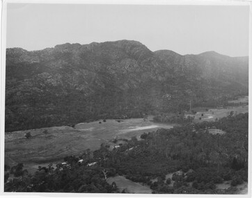 Halls Gap & Grampians Historical Society
Photograph
Photo depicts Fyans Valley. The road is The Grampians/ Dunkeld Road, leading to Dunkeld towards the right or Halls Gap travelling towards the left. Fyans Creek is visible in parts at the foot of the range (middle of Photo). Photo appears to have been taken from Bellfield Pk area. Photo is typical of those taken by Forests Commission of Victoria in the 1960sPhoto shows a mountain range in the background with a valley. The Valley has a band of a mostly cleared grassy section (middle of photo) with a fairly dense treed area in the foreground. A road and some buildings can be seen where the cleared land meets the treed area.scenery, fyans valley -
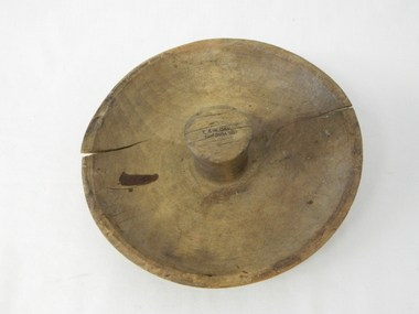 Kiewa Valley Historical Society
Mould Butter, unknown, post 1967
This butter mould/pat may have been manufactured post 1967(year post codes appeared in Australia) however the post code was only stamped on after it was machined. This type of butter mould was used by rural families to fashion home/farm made butter. This period was in most rural regions a time of self sufficiency where any domestic type implement which could be fashioned by the family would be crafted with skill. Shopping for goods required catalogues from stores located in major rural towns and cities and involved lengthy waiting times. Travelling to and from these specialised stores was not pleasant due to the relatively poor quality of the roads and the lengthy times taken. The small general stores in the Kiewa Valley could not cater for all the needs of the valley. The 1960's was a time when facilities especially goods and services started to improve drastically. The S.E.C. of Victoria with its Kiewa Hydro Electricity Scheme provided not only an improvement of facilities in the valley but also a increase in the population. This increase resulted in a greater demand for local produce. This item is one of many domestic food processing implements used by Kiewa Valley households in the mid 1900s, whether on the farm or in the small towns and hamlets. Self sufficiency was the key to survival during these early times. Where ever possible supplies from within the valley were preferred to that brought in by travelling salesmen or traders. This butter mould and butter pat was commonly used to fashion "home" made butter throughout the valley and in some cases supplied to "outside" regional towns. Although this method of production was phased out by better access to goods from nearby cities the revival of the good organic home grown produce in the 1980s saw a greater demand of this type of farm based produce.This well crafted circular wooden butter mould could also be used as a butter pat.The handle in the middle of the mould was not added after the crafting but has been fashioned from the initial block of wood when the bowl was crafted. The bowl structure has a rim around the edge.The top of the handle has an ink stamp "T. & W. Dav" on the top line and "Tawonga 3697" underneath.domestic food preparation, wooden butter pat, butter mould circular, dairy industry -
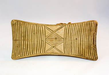 Kiewa Valley Historical Society
Pat Butter Profiler, Circa 1950s
This butter pat profiler may have been manufactured post 1967(year post codes appeared in Australia) however the post code was only stamped on after it was machined. This type of butter mould was used by rural families to fashion home/farm made butter. This period was in most rural regions a time of self sufficiency where any domestic type implement which could be fashioned by the family would be crafted with skill. Shopping for goods required catalogues from stores located in major rural towns and cities and involved lengthy waiting times. Travelling to and from these specialised stores was not pleasant due to the relatively poor quality of the roads and the lengthy times taken. The small general stores in the Kiewa Valley could not cater for all the needs of the valley. The 1960's was a time when facilities especially goods and services started to improve drastically. The S.E.C. of Victoria with its Kiewa Hydro Electricity Scheme provided not only an improvement of facilities in the valley but also a increase in the population. This increase resulted in a greater demand for local produce.This item is one of many domestic food processing implements used by Kiewa Valley households in the mid 1900s, whether on the farm or in the small towns and hamlets. Self sufficiency was the key to survival during these early times. Where ever possible supplies from within the valley were preferred to that brought in by travelling salesmen or traders. This butter mould and butter pat was commonly used to fashion "home" made butter throughout the valley and in some cases supplied to "outside" regional towns. Although this method of production was phased out by better access to goods from nearby cities the revival of the good organic home grown produce in the 1980s saw a greater demand of this type of farm based produce.This butter Pat/Profiler has on its base two patterns. On each end it has horizontal grooves cut into the wood which produce distinct lines onto the surface of the butter. between these grooves there is a section of two double lines crossing in the middle and separated by eleven horizontal lines The base has an elongated rectangular shape. The upper body has been sanded into a smooth convex shaped form where a wooden circular hand grip has been fashioned.On the top of the hand grip is stamped in black print"T. & W. Davies" and under this"TAWONGA 3697"domestic food preparation, wooden butter pat, butter mould circular, dairy industry -
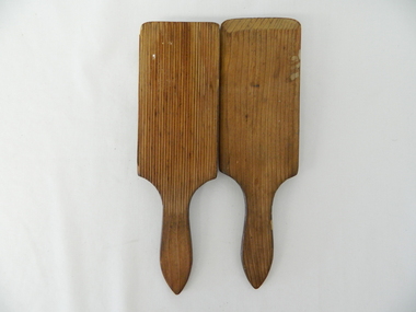 Kiewa Valley Historical Society
Pat Butter, Circa 1950
This butter pat profiler may have been manufactured post 1967 (year post codes appeared in Australia) however the post code was only stamped on after it was machined. This type of butter mould was used by rural families to fashion home/farm made butter. This period was in most rural regions a time of self sufficiency where any domestic type implement which could be fashioned by the family would be crafted with skill. Shopping for goods required catalogues from stores located in major rural towns and cities and involved lengthy waiting times. Travelling to and from these specialised stores was not pleasant due to the relatively poor quality of the roads and the lengthy times taken. The small general stores in the Kiewa Valley could not cater for all the needs of the valley. The 1960's was a time when facilities especially goods and services started to improve drastically. The S.E.C. of Victoria with its Kiewa Hydro Electricity Scheme provided not only an improvement of facilities in the valley but also a increase in the population. This increase resulted in a greater demand for local produce.This item is one of many domestic food processing implements used by Kiewa Valley households in the mid 1900s, whether on the farm or in the small towns and hamlets. Self sufficiency was the key to survival during these early times. Where ever possible supplies from within the valley were preferred to that brought in by travelling salesmen or traders. This butter mould and butter pat was commonly used to fashion "home" made butter throughout the valley and in some cases supplied to "outside" regional towns. Although this method of production was phased out by better access to goods from nearby cities the revival of the good organic home grown produce in the 1980s saw a greater demand of this type of farm based produce.This butter pat is one of two,see KVHS 0071 (B). It has been crafted from wood. One side has grooves running from the handle to the square shaped bottom. These grooves would stop the wet butter from clinging to the pat. The top side of the pat has been bevelled on both sides and the bottom edge. The hand grip is flat and curved to allow for a comfortable hold.domestic food preparation, wooden butter pat, butter mould circular, dairy industry, butter -
 Kiewa Valley Historical Society
Pat Butter Profiler, Circa 1950
This butter pat profiler may have been manufactured post 1967(year post codes appeared in Australia) however the post code was only stamped on after it was machined. This type of butter mould was used by rural families to fashion home/farm made butter. This period was in most rural regions a time of self sufficiency where any domestic type implement which could be fashioned by the family would be crafted with skill. Shopping for goods required catalogues from stores located in major rural towns and cities and involved lengthy waiting times. Travelling to and from these specialised stores was not pleasant due to the relatively poor quality of the roads and the lengthy times taken. The small general stores in the Kiewa Valley could not cater for all the needs of the valley. The 1960's was a time when facilities especially goods and services started to improve drastically. The S.E.C. of Victoria with its Kiewa Hydro Electricity Scheme provided not only an improvement of facilities in the valley but also a increase in the population. This increase resulted in a greater demand for local produce.This item is one of many domestic food processing implements used by Kiewa Valley households in the mid 1900s, whether on the farm or in the small towns and hamlets. Self sufficiency was the key to survival during these early times. Where ever possible supplies from within the valley were preferred to that brought in by travelling salesmen or traders. This butter mould and butter pat was commonly used to fashion "home" made butter throughout the valley and in some cases supplied to "outside" regional towns. Although this method of production was phased out by better access to goods from nearby cities the revival of the good organic home grown produce in the 1980s saw a greater demand of this type of farm based produce.This butter pat is one of two,see KVHS 0071 (A). It has been crafted from wood. One side has grooves running from the handle to the square shaped bottom. These grooves would stop the wet butter from clinging to the pat. The top side of the pat has been bevelled on both sides and the bottom edge. The hand grip is flat and curved to allow for a comfortable hold.domestic food preparation, wooden butter pat, butter mould circular, dairy industry -
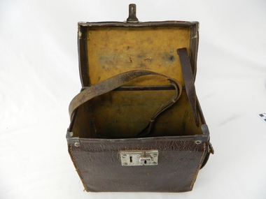 Kiewa Valley Historical Society
Case leather
This case was used between 1950 and 1980's. As part of the Occupation, Health and Safety requirements, equipment used to monitor the performance of electricity producing generators, regularly, hand held testers were used to check the insulation and the "earth" pin were up the the required operational levels. As the generators and their ancillary monitoring equipment was spread over a large area and cumbersome to service small hand held devices were required. These had to always be safe for the user to operate. A selected range of high quality meters were recalibrated every two years in the Meter and Calibration Laboratory at Yarraville(near Melbourne)This leather case contains a meter which is very significant to The Kiewa Hydro Electricity Scheme because it was an integral part of maintaining the electricity producing water driven generators of the power stations. The reason why this meter was so essential is that provided the safety check on equipment used to monitor each Hydro Generator that they were complying within the grid network parameters. Grid parameters are set so that if there is an electrical fault on the system, that fault can be attended to with a very small change in the output stability of each generator. It is essential that the voltage of the network remain within the set limits. Generators are at Dartmouth, Mackay, Clover, West Kiewa, Yarrawonga, Cain Curran and three Power Stations in the Thornton area.This carry case is made from leather hide and cloth covered cardboard insert. The front side has a lockable English made suitcase fitting. It has a broken carry strap (leather) travelling from top and through leather strap holders both sides and on the bottom of the case. A State Electricity Commission of Victoria identification tag riveted onto the top lid "ELECTRICAL ENGINEERING SECTION No. 1483"sec vic kiewa hydro scheme, alternate energy supplies, alpine located electricity generators, mobile measuring equipment -
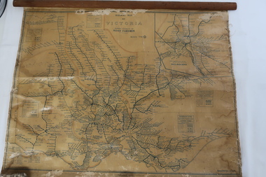 Kiewa Valley Historical Society
Map - Railway Map of Victoria, Amended to 1/11/1945
Railways began in the 1850s and were privately owned and operated. Later they were taken over by the Victorian Government reaching a peak in the early 1940s.Steam trains were followed by electric trains with both running after the war in 1945.Bright was the closest station to the Kiewa Valley but road transport was used more often as the Kiewa Valley Highway was improved with the construction of the Kiewa Hydro Electric Scheme. To travel to Melbourne or Sydney by train residents went via Wodonga/Albury where they also did their shopping.Plastic on parchment with detailed railway routes (in green) across Victoria including each district's 'Road Foremen' and 'Depots'. There is a length of flat wood attached by 10 tacks across the top of the mapvictorian railways 1945, trains, transport -
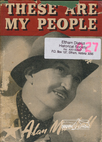 Eltham District Historical Society Inc
Book, Alan Marshall (1902-1984), These are my people / by Alan Marshall, 1944
... victoria description and travel... melbourne alan marshall victoria description and travel travel ...Hardback with dust jacket; 202 p. : ill., map ; 19 cm.alan marshall, victoria description and travel, travel, reminiscences, anecdotes, country life -
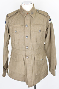 Warrnambool RSL Sub Branch
Army Jacket, 1942
This object is one of a three piece set. There is also a pair of trousers and a defence leave ticket which are associated with this object. The three chevrons on the sleeve signify three years of service. The unit patch may denote that the wearer was part of the Army Serice Corps Divisional Unit one. The associated ticket shows that the serviceman was at some point travelling in uniform on defence leave in a first class carriage from Spencer Street to either Moreland, Newmarket, North Carlton, Northcote or Westgarth.As an historic army uniform with an association to Victoria this item is of local historic and social significance. It is also in very good condition. Woolen khaki jacket with button-up front. The top button is a plain brown plastic button. The lower four buttons are identical embossed dark brown metallic buttons. They depict an image of Australia in the centre with a crown above. Encircling this image are the words "Australian Military Forces". There is also a metallic clip at the waist-band and a metallic stud below the row of buttons. There are four button-up pockets on the front of the jacket. Two of these are breast pockets and the other two sit directly beneath these. There is also an interior pocket on the lower right section of the jacket. The lower right exterior pocket is missing its button. There is a spare button in the right breast pocket. All of these pocket buttons are of the same type as the decorative dark brown metallic buttons. There is also a spare unit patch in the bottom right pocket. The two cuffs are buttoned up with one decorative dark brown metalic button each. There are two identical brass badges on either collar. They depict a crown in the centre with the rising sun surrounding it and ribbons below with the words "Australian Commonwealth Military Forces". There are two identical brass badges on the shoulder edges of the epaulettes depicting the word "Australia". There are two buttons that fasten the epaulettes to the jacket near the neck which are of the same type as the decorative dark brown metallic buttons. There are two identical felt unit patches on either section of the upper arms. They have a light blue border surrounding a navy blue rectangle above a white rectangle. There is also a felt chevron just above the cuff on the right arm. This depicts three blue stitched arrows on a khaki/green background. There are also two labels stitched to the interior of the right breast pocket. Ther are two white rectangular labels that are stitched to the interior of the right breast pocket. These have inscriptions. There is also a stamp on the interior of the lower right pocket.Inscription on the two interior Labels: REGIMENTAL No........./ NAME........./ V.162 / MADE IN AUSTRALIA / 1942 / SIZE / (within a rectangle the number “26”) Stamp on the interior of the lower right pocket inscription: W.W. ( and what appears to be an upside-down W above thesearmy, uniform, jacket, army service corps, asc, divisional unit one, division one -
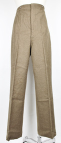 Warrnambool RSL Sub Branch
Army Trousers, 1942
These trousers are a part of a three piece set. There is also a jacket and a defence leave ticket which are associated with this item. There are three chevrons on the sleeve of the jacket which signify three years of service. The unit patch may denote that the wearer was part of the Army Serice Corps Divisional Unit one. The associated ticket shows that the serviceman was at some point travelling in uniform on defence leave in a first class carriage from Spencer Street to either Moreland, Newmarket, North Carlton, Northcote or Westgarth.As an historic army uniform with an association to Victoria this item is of local historic and social significance. It is also in very good condition. Long woollen button-up khaki trousers. There are six metallic buttons that fasten the fly and six more around the exterior part of the waistband. There are also two pockets on either side just below the waistband. army, uniform, jacket, army service corps, asc, divisional unit one, division one -
 Warrnambool RSL Sub Branch
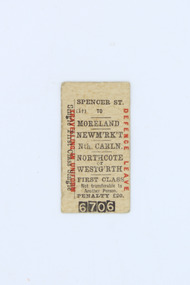
Defence Leave Ticket, Approximately 1942
This ticket is part of a three piece set. There is also an Army Uniform (jacket and trousers) which are associated with this item. The ticket was found within one of the front pocekts of the jacket. There are three chevrons on the sleeve of this jacket which signifies three years of service. The unit patches on the shoulders may denote that the wearer was part of the Army Serice Corps Divisional Unit one. The ticket shows that the serviceman was at some point travelling in uniform on defence leave in a first class carriage from Spencer Street to either Moreland, Newmarket, North Carlton, Northcote or Westgarth.As an historic train ticket with an association to Victoria and the Army Service Corps this item is of local historic and social significance.A rectangular light brown paper card with printed ink inscriptions on the front and back.Horizontal inscriptions on the front in black ink: SPENCER STREET / (1 [symbol of a cross] ) TO / MORELAND / NEWM’RK’T / Nth. CARLN. NORTHCOTE / or / WESTGARTH / FIRST CLASS / Not transferable to Another Person. / PENALTY £20. / (the numbers 6706 surrounded by black rectangular backgrounds) Vertical inscriptions on the front in black ink along the left edge: Single First Class Single Vertical inscriptions on the front in red ink along the left edge: TRAVELLING IN UNIFORM Veritcal inscriptions on the front in red ink along the right edge: DEFENCE LEAVE Horizontal inscriptions on the back in black ink (this inscripion is right side up along the top edge and also upside down along the bottom edge): 13F E441army, uniform, jacket, army service corps, asc, divisional unit one, division one, train ticket, train, ticket, defence leave, defnce leave ticket -
 Victoria Police Museum
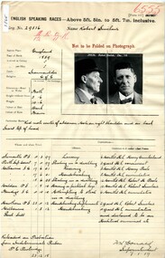
Prison record (Robert Sinclair), 23 December 1918
Robert Sinclair, a travelling entertainer, committed a variety of offences including housebreaking, having a skeleton/picklock key in his possession, being an habitual criminal. He had several aliases. Prison record for Robert Sinclair, prisoner registered number 29536, giving details of the prisoner, his crimes and the dates and places of his trials.robert sinclair, english speaking prisoner, larceny, housebreaking, stealing -
 Eltham District Historical Society Inc
Photograph, Tom Prior, Police Station and Residence, Maria Street, Eltham, c.1900
Situated near the top of what was known as 'Policeman's Hill' according to Miss Ivy Reynolds, neice of the photographer, Tom Prior. From the left, Eltham Court House, Police Residence and Police station on Main Road and corner of Brougham Street. These buildings formed part of Little Eltham and still stand (without the front fence) today though the Police Station was demolished in 1986 due to termite damage. A replica was built circa 1989. The institutions of law and order in Colonial Victoria included the police, courts and prisons. The 1852 report of the Snodgrass Select Committee appointed to "identify the policing needs of the colony” noted there existed seven independent police forces that did not co-operate or regularly communicate. Following the committee's report all these police entities were merged into the Victoria Police, founded on 8 January 1853, to implement law and order responsibilities throughout the Colony of Victoria. The Eltham Courthouse (1860) and adjacent Police Residence (1859) formed a justice precinct established in the immediate aftermath of the 1852 police inquiry and the effects of the gold rush. The physical presence of these buildings, in the centre of the early Eltham township, defined centralised control over law and order. In the early days the Police Constable in charge would conduct his duties travelling around the district by horse; a stable was located at the rear of the residence. At times the horse would be grazed on the paddocks across the road. Horseshoes were forged by the blacksmith beside the Courthouse on the high side of “Policeman’s Hill”. Along with the stable, there was a two-cell bluestone lockup where prisoners were held awaiting trial in the adjacent Courthouse. Their meals were usually provided by the policeman’s wife or from the hotel just up the road. With the arrival of the railway in 1902 the town centre gradually shifted towards the railway station. The Police Station and operations were moved into the town centre in 1961 to a renovated house in Pryor Street, which was later replaced by the current Police Station. From 1961-1981 the residence was occupied by the Vermin and Noxious Weeds Destruction Section of the Department of Crown Lands and Survey. Prior to August 1967 the former Police Station was dragged to the rear of Police Residence to make way for the construction of a driveway and access from Main Road. The building was placed on the site of a former Scullery and modified for Lands Department use. In 1981 the Shire of Eltham took over management of the former Police Residence in Eltham. It remained unoccupied for a period whilst its future was discussed in Council. It was then used for a community job creation scheme until 1985. In 1985 the Shire of Eltham Parks and Environment occupied the residence. Council improved the driveway but later added a second rear access from Brougham Street due to the dangerous nature of the Main Road entrance. Additionally, a rear toilet facility between the Police Residence and the relocated former Police Station, which was doubling up as a lunchroom. Council also commenced discussions to re-establish a replica Police Station. Around November 1986 the former Police Station was demolished; believed to have been suffering termite damage. About 1989, after some years of discussion, a replica Police Station was built, based on photographs, to act as a lunchroom and meeting room for the Parks and Environment staff and volunteers doing community service. In 1996 Eltham District Historical Society held discussions with Nillumbik Shire Council commissioners throughout the year regarding a home for the Society. A proposal was put forward by the Society in October to occupy the former Police Residence. In March 1997 Eltham District Historical Society gained access to former Police Residence and on July 12, 1998, moved into its Local History Centre. In July 2018, Eltham District Historical Society gained access to the replica Police Station (which had been used as a music library and storage for the Eltham Concert Band) for use as part of regular heritage tours for schools and community-based groups.This photo forms part of a collection of photographs gathered by the Shire of Eltham for their centenary project book,"Pioneers and Painters: 100 years of the Shire of Eltham" by Alan Marshall (1971). The collection of over 500 images is held in partnership between Eltham District Historical Society and Yarra Plenty Regional Library (Eltham Library) and is now formally known as 'The Shire of Eltham Pioneers Photograph Collection.' It is significant in being the first community sourced collection representing the places and people of the Shire's first one hundred years. The Reynolds family were early settlers in Research. The Reynolds/ Prior collection of photographs were taken by Tom Prior, the maternal uncle of Ivy Reynolds, around 1900 and the 60 photos in the album give a fine overview of many of the landmarks of Research and Eltham over 100 years ago. lvy lived in the family home for many years at 106 Thompson Cres Research. Ivy's father, Ernst Richard Reynolds and grandfather, Richard Reynolds, lived at the same address. Ivy's father Richard worked for Mr. Trail on his property in Research. Reynolds Road is named after the family. Mr Tom Prior (wife Eva) worked at the Melbourne zoo. He was very innovative and made his own camera, using the black cloth hood to exclude the light. The photographs are a reminder of the rural nature of Research and Eltham and its rich heritage.Digital imagechildren, court house, courthouse, eltham, eltham district historical society, eltham justice precinct, little eltham, local history centre, main road, police residence, police station, reynolds prior collection, sepp, shadow, shire of eltham pioneers photograph collection -
 Orbost & District Historical Society
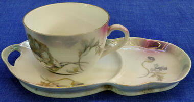
cup and saucer
This was used at Dr Kerr's tennis court. Dr James Kerr visited Orbost on Govt vaccinating job and settled in Orbost the next year. He served in Orbost for 40 years travelling everywhere on horseback.Dr James Kerr was Orbost's first doctor.Cup and saucer set. White cup with delicate floral pattern. Large saucer with extra section for biscuit in same floral pattern has cut-out section on saucer/plate.Bottom - Victoria, Australiakerr-james crockery china cup saucer -
 Orbost & District Historical Society
display cabinet and tools
This display was put together by the Curlip Committee and used as promotion in the shed during the construction of Curlip 11 A community project, this boat was constructed out of local hardwood timbers utilizing the traditional skills of wooden boat builders and is powered by a steam engine. Paddle Steamer Curlip II is a replica of an historic paddle steamer of the Snowy River, in Far East Gippsland, Victoria. The original Paddle Steamer Curlip was built by Sam Richardson and his sons Mark, Albert and Frank, at their sawmill at Tabbara, a pioneering settlement on the Brodribb River, a tributary of the Snowy River. The keel was laid on 14th October 1889 and PS Curlip was launched in 1890. The name “ Curlip” is derived from the indigenous name for the area where Tabbara is located and includes land to the east of the Snowy and Brodribb Rivers towards Cape Conran. PS Curlip was registered in 1893 and the Passenger Certificate issued on 30th January 1903 to Captain Alan Richardson by the Marine Board of Victoria entitled her to carry 25 passengers and only 10 passengers when engaged in towage service. Two children under 12 years of age to be reckoned as one passenger. PS Curlip towed five barges at a time, traveling upstream as far as Bete Bolong, 20 km upstream of the mouth to collect produce to be transferred to schooners near Marlo. She towed vessels in and out through the Snowy river entrance and was also used for social functions such as Sunday School picnics. She was the main means of transport for imports and exports on the Snowy River for almost 30 years. The Curlip era ended abruptly on Friday 28th February when a flash flood carried her and 2 barges down river and out to sea, where she washed ashore at Marlo and broke up.More than eighty years after the original Paddle Steamer Curlip was wrecked at sea, the Orbost community launched a replica which it hoped would draw tourists to the region. The P.S. Curlip II, is based on drawings of the original Curlip that made its home in the Snowy and Brodribb Rivers of East Gippsland in the 1890s and early 1900s, It took six years of planning and hundreds of hours of volunteer work from the local community.A display cabinet containing tools and sundry items related to the Paddle Steamer Curlip. (More information on individual items in Catalogue 1400-1600)p.s.curlip richardson-samuel boat-building-tools transport -
 Orbost & District Historical Society
ledger, 1950's -1960's
This ledger was used bt the Shire of Orbost local government to record Country Roads Board accounts 1950's and 1960's. The item was donated to Orbost & District Historical society from P.R.O.V. as a Place of Deposit (POD) item for safe keeping by a local history group or museum. The shire covered an area of 9,347 square kilometres and existed from 1892 until 1994 when it became part of the East Gippsland Shire Council. Orbost was at first included in the Bairnsdale Shire from 1882 and was later part of the Tambo Shire. Because of travelling distances the Croajingalong Shire was created in 1892 (name changed to Orbost Shire 17.2.1893 with James Cameron as the first Shire President. In 1994 it amalgamated to become part of East Gippsland Shire Council. The Country Roads Board was the government authority for the construction and maintenance of main roads in Victoria between 1913 and 1983. It was succeeded by the Road Construction authority on 1 July 1983 and later merged with the Road Traffic Authority on July 1 1989 to form the Roads Corporation. James Cameron, an Orbost farming pioneer and Member of the Legislative Assembly, fathered the Country Roads Board. This ledger is a hand-written record of accounts for the Orbost Shire local council. It pre-dates computer records. The Orbost Shire Council no longer exists having been absorbed into the East Gippsland Shire Council.A heavy brown coloured ledger with covered wooden covers. it has steel metal binding. Inside are strips of paper marking pages. It contains blue ink hand-written records of monies in/out (?) to Shire of Orbost Council. On the front cover inside a black rectangle in gold print is " LEDGER COUNTRY ROADS BOARD ACCOUNT ORBOST". It is an "Emu Binder".ledger orbost-shire accounts country-roads-board -
 Orbost & District Historical Society
ledger, 1950's ; 1960's
This ledger was used by the Shire of Orbost to record transactions with the Country Roads board in 1950's and 1960's. The item was donated to Orbost & District Historical society from P.R.O.V. as a Place of Deposit (POD) item for safe keeping by a local history group or museum. The shire covered an area of 9,347 square kilometres and existed from 1892 until 1994 when it became part of the East Gippsland Shire Council. Orbost was at first included in the Bairnsdale Shire from 1882 and was later part of the Tambo Shire. Because of travelling distances the Croajingalong Shire was created in 1892 (name changed to Orbost Shire 17.2.1893 with James Cameron as the first Shire President. In 1994 it amalgamated to become part of East Gippsland Shire Council. The Country Roads Board was the government authority for the construction and maintenance of main roads in Victoria between 1913 and 1983. It was succeeded by the Road Construction authority on 1 July 1983 and later merged with the Road Traffic Authority on July 1 1989 to form the Roads Corporation. James Cameron, an Orbost farming pioneer and Member of the Legislative Assembly, fathered the Country Roads Board. This item is a hand-written record of accounts of the Orbost Shire local Government. It pre-dates computer records,The Shire of Orbost Council no longer exists having been absorbed into th East Gippsland Shire council.A heavy brown coloured ledger with steel bindings. Covers are probably wooden. It contains hand-written records of transactions the Country Roads Board. -
 Orbost & District Historical Society
ledger, late 1950's - 1970's
This ledger was used by the Shire of Orbost in the late 1950's - 1970's.The item was donated to Orbost & District Historical society from P.R.O.V. as a Place of Deposit (POD) item for safe keeping by a local history group or museum. The shire covered an area of 9,347 square kilometres and existed from 1892 until 1994 when it became part of the East Gippsland Shire Council. Orbost was at first included in the Bairnsdale Shire from 1882 and was later part of the Tambo Shire. Because of travelling distances the Croajingalong Shire was created in 1892 (name changed to Orbost Shire 17.2.1893 with James Cameron as the first Shire President. In 1994 it amalgamated to become part of East Gippsland Shire Council. The Country Roads Board was the government authority for the construction and maintenance of main roads in Victoria between 1913 and 1983. It was succeeded by the Road Construction authority on 1 July 1983 and later merged with the Road Traffic Authority on July 1 1989 to form the Roads Corporation. James Cameron, an Orbost farming pioneer and Member of the Legislative Assembly, fathered the Country Roads Board This item is a hand-written record of Orbost Shire Council accounts. It pre- dates computer records. The Shire of Orbost local council no longer exists having been absorbed by the East Gippsland Shire Council.A black ledger with wooden covers. It contains hand-written records of transactions between Orbost Shire Council and the Country Roads Board.bottom left corner - Orbost in black on a white East Gippsland Shire logoledger accounts shire-of-orbost country-roads-board -
 Cheese World Museum
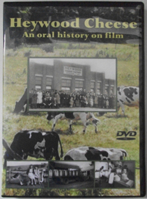
DVD, Heywood Cheese; an oral history on film
For many years the Heywood Cheese Factory was an important part of life for Heywood and district farming and a vital place of employment for up to 40 men and 10 women. The factory opened in 1939 as a subsidiary of the Portland Butter Factory before becoming a world renowned cheese making enterprise. It was felt important to document its history from the surviving factory workers, including dairy suppliers and milk truck drivers. We hear their stories of the long hours and hard work without penalty rates, travelling unsealed roads and mixed with their humour of the bygone days is an important acknowledgement of that era. [blurb on back cover]This oral history provides significant material relating to the dairy industry in south west Victoria during the mid 20th century. The interviews give first-hand recollections of the interviewees involvement in the industry from a point of view of factory workers, milk pick-up drivers and farmers.Full colour DVD cover has photograph of Heywood Cheese factory and photographs of girls with calves, milk cans on a truck and workers in the cheese room, superimposed on a photograph of dairy cows grazing in a paddock. The DVD has the photograph of the cows grazing in the paddock.Heywood Cheese/An oral history on film (front) For many years Heywood Cheese Factory was ... [see historical information] Edited by Garry Kerr for the Heywood Pioneer Wagon Shed/ Museum History Group who wish to gratefully acknowledge the/ support of the Victorian Government and Public Records Office/ Victoria for making this project possible. Duration: 70 minutesallansford, heywood, cheese factories, cheese manufacturing, dairying, cheese -
 Flagstaff Hill Maritime Museum and Village
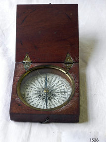
Instrument - Compass, c. 1839
This magnetic compass is a good size to fit easily into a person's pocket or personal luggage and is protected from knocks by its wooden case. It could have been used for reference when travelling on land or sea. There is no visible manufacturer's mark, which may mean that it was not of high monetary value. Leith is a district of Edinburgh in the country of Scotland, the U.K. It was once the Port of Edinburgh and many migrant ships departed from here bound for the Australian colony. It had a busy shipbuilding industry, with wet and dry docks. It appears from the inscription on the case "Chas Gray, LEITH, 1839" that this pocket compass once belonged to Charles M. Gray (Chas is a common abbreviation for the name Charles). The inscription coincides with the name, place and date that the Western Victorian pioneer Charles M. Gray left Scotland and arrived in Australia. Charles Gray was born in Anstruther, Scotland, in 1818. His family was connected with the Royal Marines, which may have created his nautical instruments such as this pocket compass. Charles Gray arrived in Hobson's Bay on 15 June 1839 on the ship “Midlothian”. That same ship had departed from Leith, Scotland on February 15th 1839. Did Charles Gray acquire the pocket compass in Leith, perhaps as a gift or a souvenir of his motherland? Charles Gray was an early squatter and went on to become a very successful settler as a sheep pastoralist in the Western District of what is now Victoria (originally the colony of New South Wales). He and his wife had a large property called “Nareeb Nareeb”, Green Hill Creek District (now Glenthompson), Victoria, from 1840-1886. He was also a local Councillor and Justice of the Peace, and had an interest in the local indigenous people; he named his property after their tribe. Charles returned to England in 1890 and died there in 1905. Charles Gray had written an account in 1890 of his life at Nareeb Nareeb, called Western Victoria in the Forties: "REMINISCENCES OF A PIONEER The Western District in the 1840's By Charles Gray" , a valuable historical reference to colonial Victoria. His book was published by the Hamilton Spectator in 1932. Charles Gray's photograph is one of 713 historical photographs of early Victorian settlers, created as a montage by Thomas Foster Chuck in 1872. The State Library of Victoria holds the framed montage titled “The Explorers and Early Colonists of Victoria”. To qualify for inclusion on this montage the Settlers must have arrived in Victoria before 1843. Charles Gray's photograph is number 349! The pocket compass is associated with Charles Gray, one of the early squatters and settlers in Western Victoria, possibly given to him as a parting gift on his emigration to Van Diemans land in 1839. The item is very significant as it's connection with one of Victoria's early pioneers is well provenanced by the inscriptions on the wooden case. Pocket compass, brass, set into a square wooden case with hinged lid and small hook catch. Compass is marked with 360 degrees and compass points and has two pointers; one to show magnetic north and one to set the direction of travel. Hinges are triangular and inset into the wood. The lid has an attached brass plaque with the inscription "Chas Gray, Leith, 1839" (It likely belonged to Charles Gray, Leith, UK, who migrated to Port Philip Australia in 1839 and became a successful pastoralist.) “Chas Gray / LEITH / 1839” engraved on brass plaque on lid.flagstaff hill, warrnambool, shipwrecked coast, flagstaff hill maritime museum, maritime museum, shipwreck coast, flagstaff hill maritime village, great ocean road, magnetic compass, pocket compass, charles m. gray, chas gray, migrrant from leith 1839, charles gray anstruther, scottland, ship midlothian 1839, squatter western victoria, settler western victoria, hobson's bay port phillip australia, charles gray nareeb nareeb - green hill creek district, western victoria in the forties: reminiscences of a pioneer by charles m. gray 1890, leith edinburgh u.k., western victoria in the forties: reminiscences of a pioneer - montage by thomas foster chuck 1872, charles gray, reminiscences of a pioneer, the western district in the 1840's, compass, scientific instrument, nautical instrument, direction, directional compass, navigation -
 Flagstaff Hill Maritime Museum and Village
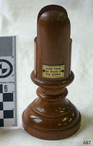
Card Holder, c. 1854 - 1957
This wooden cardholder has been made from the wood of the screw steamer S.S. Edina, most probably after she was broken up in 1957, but could have been made after one of several renovations during her lifetime. The slotted design of the cardholder allows a card to stand vertically and the base is made wider to stableise the holder. It could be used for holding items such as place cards, menus, table numbers. ABOUT THE S S EDINA The three masted iron screw steamer SS Edina was built in Glasgow, Scotland, in 1854 by Barclay and Curle. She was adorned with the figurehead of ‘fair maid of Judea’. The many years of service made SS Edina famous worldwide as the longest serving screw steamer. (The term screw steamer comes from being driven by a single propeller, sometimes called a screw, driven by a steam engine.) SS Edina’s interesting history includes English Chanel runs, serving in the Crimean Ware carrying ammunition, horses and stores to the Black Sea, and further service in the American Civil War and later, serving in the western district of Victoria as well as in Queensland and carried gold, currency and gold prospectors Australia to New Zealand. SS Edina had the privilege of being an escort vessel to H.R.H. the Duke of Edinburgh during his visit to Australia in 1867. In March 1863 SS Edina arrived in Port Phillip Bay, Melbourne, and was bought by Stephen Henty, of Portland fame, to work the cargo and passenger run from Melbourne – Warrnambool – Port Fairy - Portland. After a short time of working the run from Australia to New Zealand, with passengers and cargo that included gold and currency, she returned to her Melbourne - Warrnambool – Port Fairy run, with cargo including bales of wool produced in the western district of Victoria. The Warrnambool Steam Packet Company purchased SS Edina in 1867; she was now commanded by Captain John Thompson and Chief Engineer John Davies. She survived several mishaps at sea, had a complete service and overhaul, and several changes of commanders. In 1870 SS Edina was in Lady Bay, Warrnambool, when a gale sprung up and caused a collision with the iron screw steamer SS Dandenong. SS Edina’s figurehead was broken into pieces and it was not ever replaced. SS Edina was re-fitted in 1870 than was used as a coastal trader in Queensland for a period. She was then brought to Melbourne to carry cargo and passengers between Melbourne and Geelong and performed this service 1880-1938. During this time (1917) she was again refitted with a new mast, funnel, bridge and promenade deck, altering her appearance. In 1938, after more collisions, SS Edina was taken out of service. However she was later renamed Dinah and used as a ‘lighter’ (a vessel without engine or superstructure) to be towed and carry wool and general cargo between Melbourne and Geelong. In 1957, after 104 years, the SS Edina was broken up at Footscray, Melbourne. Remains of SS Edina’s hull can be found in the Maribyrnong River, Port Phillip Bay. [Reference: A Brief Review of Steam Navigation in Victoria; C Dickson Gregory; Centenary Maritime Exhibition catalogue, 1934; published by Shiplovers' Society of Victoria Dandenong, Passengers in History, http://passengersinhistory.sa.gov.au/node/924034 Edina, Victorian Heritage Database VHR S199 http://vhd.heritage.vic.gov.au/shipwrecks/heritage/199 SS Edina, Coastal Trader and Passenger Ship 1853-1938, Museum Victoria Collections, https://collections.museumvictoria.com.au/articles/6227 SS ‘Edina’ – the Longest Serving Screw Steamer in the World, POI Australia, https://poi-australia.com.au/ss-edina-the-longest-serving-steamer-in-the-world/ ]This card holder is made from wood from the SS Edina and is significant for its association with that vessel. The SS Edina is heritage listed on the Victorian Heritage Database VHR S199. She had endeared herself to the people of Port Phillip Bay as a passenger ferry, part of their history and culture. She played a significant role in the Crimean War, the American Civil War and the gold rush in New Zealand. She also served western Victoria for many years in her cargo and passenger runs. The SS Edina is famous for being the longest serving screw steamer in the world. After spending her first nine years overseas she arrived in Melbourne and her work included running the essential service of transporting cargo and passengers between Melbourne and the western Victoria ports of Warrnambool, Port Fairy and Portland. The SS Edina was purchased in the late 1860’s by local Warrnambool business, the Warrnambool Steam Packet Co. and continued trading from there as part of the local business community. The SS Edina’s original ‘fair maid of Judea’ figurehead was broken to pieces in a collision with another vessel (the SS Dandenong) in a gale off Warrnambool, Victoria, in 1870. Card holder, made from the wood from the SS Edina (screw steamer ship). Holder is cylindrical shape, wider turned wood base. Top is divided with a space in the centre tor inserting a card. Rectangular metal plaque, gold coloured, has a printed inscription within black border. Made c. 1854 - 1957.Printed in black lettering on gold coloured plaque "MADE FROM / THE WOOD OF / S.S. EDINA"warrnambool, shipwrecked coast, flagstaff hill, flagstaff hill maritime museum, maritime museum, shipwreck coast, flagstaff hill maritime village, shipwrecked artefact, barclay & curle, figurehead 'fair maid of judea', centenary maritime exhibition 1934, a brief review of steam navigation in victoria, pleasure steamer edina, trade and travel late 19th and early 20th century, trade melbourne to geelong, screw steamer edina, coastal trader edina, lighter dinah, cargo carrying for cremean war, cargo carrying for american civil war, passenger and trade in western district of victoria, export gold and currency and gold diggers to new zealand, export vessel to h r h the duke of edinburgh, melbourne - warrnambool - port fairy - portland cargo run, warrnambool steam packet company, stephen henty, captain john thompson, chief engineer john davies, lady bay warrnambool, lighter edina, shipping victoria, port phillip bay steamers, steamship great britain, edina, vhr s199 victorian heritage database, card holder, menu holder, table number holder, souvenir of the ss edina -
 Marysville & District Historical Society
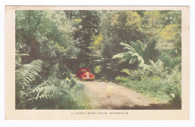
Postcard (item) - Colour postcard, Nucolorvue Productions, A Lovely Bush Track, Marysville, 1950's
An early colour photograph of a car travelling along Lady Talbot Drive in Marysville in Victoria.An early colour photograph of a car traveling along Lady Talbot Drive in Marysville in Victoria. Lady Talbot Drive a 24 kilometer scenic rainforest car journey which passes a number of walks and waterfalls in the Yarra Ranges National Park. Lady Talbot Drive is named after Lady Sarah Elizabeth, the wife of Sir Reginald Talbot, who was the Governor of Victoria from 25th April, 1904 to 6th July 1908. This road was originally constructed as a corduroy road (or log road) is a type of road or timber trackway made by placing logs, perpendicular to the direction of the road over a low or swampy area. The result is an improvement over impassable mud or dirt roads, yet rough in the best of conditions and a hazard to horses due to shifting loose logs. This postcard was produced by Nucolorvue Productions in Elwood, Victoria as a souvenir of Marysville.POST CARD NUCOLORVUE PRODUCTIONS, ELWOOD, VICTORIAmarysville, victoria, nucolorvue productions, postcard, souvenir, lady talbot drive, lady talbot forest drive, sir reginald talbot, lady sarah elizabeth talbot, corduroy road