Showing 6697 items
matching river
-
 Bendigo Historical Society Inc.
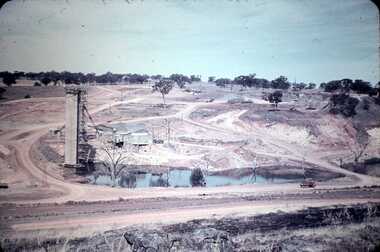
Slide - DAVID MCDONALD COLLECTION: EPPALOCK. CONSTRUCTION, c1960
Eppalock. Construction. Slide shows the water tower, workmen's huts and some trucks etc. Shows large pool of water with another of to the right these would have been part of Coliban River.Agfacolorcivil engineering, water supply, eppalock -
 Bendigo Historical Society Inc.
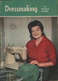
Magazine - AILEEN AND JOHN ELLISON COLLECTION: DRESSMAKING
Magazine: dressmaking by Lucille Rivers, supplement to the Australian Women's Weekly, not to be sold separately. On the cover a lady wearing a red cardigan sitting at a Singer sawing machine. The magazine has 48 pages.books, magazines, dressmaking -
 El Dorado Museum Association Inc.
Photograph (item) - Digital Image
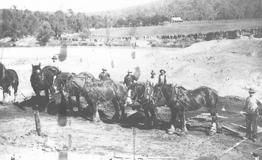
Horse team , Cocks Pioneer Cocks Pioneer Electric Gold & Tin Mine Company was formed in 1899. The company's first power station, located at the eastern end of the valley began operating with its 340 Kilowatt steam-powered generator. By 1909, from 2,500,000 cubic yards worked, reported recovery was 17 284 ounces of gold and 224 tons of tin ore. By 1909, Cocks Pioneer’s power plant had become inadequate and uneconomical. The barge was floated downstream about a mile, but lost time caused the operations to cease. Following testing, a new mine was established by diverting Reid's Creek at a cost of £25,000. Settling dams were built, one of which held 1,935,900 cubic feet. Sold earth banks, built against a wall of stringy bark saplings constructed and laced with vertical props, were built. In 1914, the company was reformed as Cock’s Pioneer Gold and Tin Mines NL, another power station was constructed at the western end of the township, near the junction of Clear and Reid's Creeks. From 6,800,000 cubic yards of material processed, the returns were 64,397 ounces of gold and 855 ton of tin. Cocks Pioneer mine then moved the barge downs stream and continued sluicing. In 1929 Cocks Pioneer Electric Gold and Tin Mining Company ceased operations due to a drop in values. Cock’s Pioneer Gold and Tin Mines NL carried on large-scale hydraulic sluicing operations until 1941. mining, gold, tin, sluicing, men, cocks pioneer, el dorado, eldorado, horses, gold mining, tin mining -
 Tatura Irrigation & Wartime Camps Museum
Book, Yates Annual 1941, 1941
On front cover photograph of colourful columbines on banks of Derwent River Tasmania. On back cover colour photograph of best six roses for 1941. Information about Yates seeds, plants and bulbs.yates garden catalogue, growing roses, growing annuals -
 Victorian Aboriginal Corporation for Languages
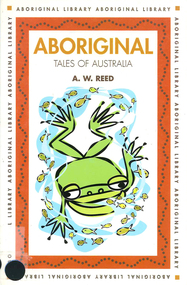
Book, A W Reed, Aboriginal tales of Australia, 1998
Populated by mythical beings, these stories of heros, birds, rivers, lakes and shores have been passed down over generations and today offer a window of understanding into the powerful Aboriginal connection to the land.word listscreation stories, dreamtime -
 Victorian Aboriginal Corporation for Languages
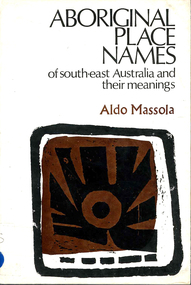
Book, Aldo Massola, Aboriginal place names of south-east Australia and their meanings, 1968
A first attempt to make a complete collection of all recorded Aboriginal names of towns, shores, homesteads, rivers, swamps, mountains and other natural features of south-east Australia. Gives meanings.word listsvocabulary, word lists, south east australian languages -
 Otway Districts Historical Society
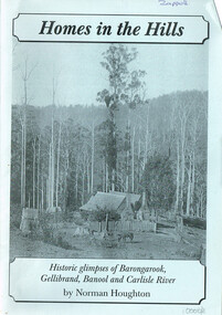
Book, Norman Houghton, Homes in the Hill; Norman Houghton, 2006
Homes in the Hills. Historic glimpses of Barongarook, Gellibrand, Banool and Carlisle River. Norman Houghton. Soft cover. iv, 48 p.; illus, map, diagram. Artwork and layout: Desktop Dymanics. otway ranges; norman houghton; barongarook; gellibrand; banool; carlisle river; agriculture; mining; sport; homes; hills; -
 Kew Historical Society Inc
Photograph - Men on the bank of the Yarra River, circa 1953
This is one of a series of 17 black and white undated photographic proofs donated to the Kew Historical Society in 2013 by the Queenscliffe Historical Museum. The series includes images of individuals, tea rooms, ferries, motor launches, ocean liners and tugs. The subject of the photograph is a Hicks Bros ferry, which from circa 1921 operated a ferry service from Princess Walk (Melbourne) to Studley Park.Very faded and degraded photograph of a group of men walking down pathways on the bank of a river in Melbourne. The location may be the Hawthorn Tea Rooms. The undated photographic positive was probably taken in the 1950s.melbourne, tourism -
 Kew Historical Society Inc
Photograph - Zig-zag Bridge on the Yarra River at Kew, Henry Beater Christian, 1920-28
Henry Christian (c.1809-91), the grandfather of the photographer, was one of the first settlers in Kew. He arrived in Victoria with his wife Agnes and son Orlando in 1855 on the Gypsy Queen. He established a rope-making business in Bulleen Road by 1858 but was declared insolvent two years later. In his final years, he was celebrated as one of the oldest living settlers of the district. His son, Orlando Henry Beater Christian (c.1853-1930) became a member of the Hawthorn Band and a foundation member of the Willsmere Swimming Club. Orlando and his wife Elizabeth had four children of which Henry Beater Christian (1886-1962) was the eldest.Small black and white photograph of the Yarra River at Studley Park. In the middle ground, a man is paddling a canoe upstream. On the horizon, the tower and buildings of Raheen in Studley Park Road can be seen.henry christian (1886-1962), landscape photography, kew canoe club history — — photographs, yarra river -- studley park -- kew (vic.), christian-washfold collection -
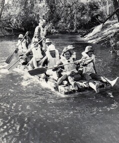 8th/13th Victorian Mounted Rifles Regimental Collection
Photograph
Units conducted Adventure Training to build team values.Black and white photograph of soldiers on a raft made of jerry cans engaged in Adventure Training on Ovens River, December 1976.Sodiers from Administrative Troop 8/13Victorian Mounted Rifles..Adventure Training, S/Sgt. M.Miles,Lt Shefford, Sgt S. Berg, Major I Docking, Pte H Delaney, Pte M Clarke" -
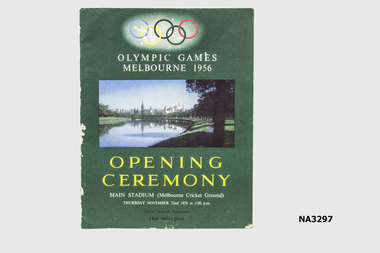 Whitehorse Historical Society Inc.
Programme - Programme - Opening Ceremony 1956 Olympic Games, c1956
Used at Opening Ceremony by Edward Arrowsmith, 1956Green coloured programme. Five Olympic Rings in blue, yellow, black, green and red. Photograph of Melbourne including Yarra River. Thirty-one pages including history of Olympic movement.'Opening Ceremony. Main Stadium (MCG) Thursday November 22nd 1956 at 3 p.m. Official Souvenir Programme. Two shillings. Olympic Gamesdocuments, programmes -
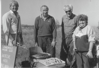 Lakes Entrance Historical Society
Photograph - Johnsonville Angling Club, Lakes Post Newspaper, 1996
Black and white photograph Ray Mengler, Bob Hutchinson, Fred Clark and Val Ingle.Johnsonville Angling Club at Tambo River bank preparing Barbeque at tree planting project.East Gippsland, Victoriavolunteering, environment, clubs -
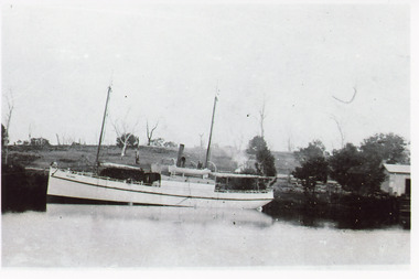 Lakes Entrance Historical Society
Photograph - S.S. Bellbird, 1906 c
Bellbird built by George Fraser 1905, went to NZ with Fraser familyBlack and white photograph showing S S Bellbird at Johnsonville on Tambo River, shows wharf and shed on right hand side, few dead trees on hill in background. Johnsonville Victoriaboats and boating, waterways -
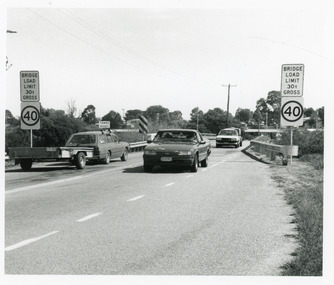 Lakes Entrance Historical Society
Photograph, 1994
Date made March 1994Black and white photograph showing traffic and restriction signs on Swan Reach Bridge, over theTambo River prior to funding being made available for strengthening and widening. Swan Reach Victoriabridges, waterways, vehicles -
Lakes Entrance Historical Society
Book, East Gippsland Estuary Entrance Management Protocols 2013, 1913
A report prepared by Water Technology Pty Ltd for East Gippsland Catchment Management Authority relating to the management of the four estuaries, Lake Tyers, Snowy River, Sydenham Inlet, and Mallacoota Inlet.water supply -
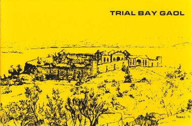 Bendigo Historical Society Inc.
Book - STRAUCH COLLECTION: TRIAL BAY GAOL
Trial Bay opened in 1886 after 13 years construction. It was designed for prisoners who were low risk and nearing the end of their sentences. From here they would participate in Public Works projects. It was named Trial Bay after the brig "Trial" sank there. This ship had been commandeered by convicts in Port Jackson and forced to sail north. Between 1915 and 1918 the prison became a detention centre for German citizens.Trial Bay Gaol, Public Works Prison and Wartime Detention Camp, a Macleay River Historical Society publication Kempsey, New South Wales, small booklet with black and white photographs.Marie h Neilhistory, australian, prisons, australia-history-nsw-prisons -
Tatura Irrigation & Wartime Camps Museum
Booklet, K Gregory, B Pearson, W Stewart et al, From Protectorate to Smaller Town, 1985
2nd book. L3518. Incorporating 125 years of education and achievement Murchison Primary School 1860-1985. Booklet for "Back to Murchison" 18-20 October 1985.Yellow soft cover booklet. Green text and 2 pictures on front. Top on of river scene. Lower scene of street buildings. Aerial scene of town on back cover. 79 pages -
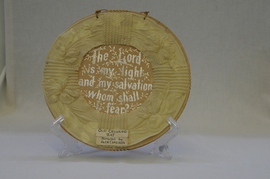 Orbost & District Historical Society
ornament, late 19th - first half 20th century
Owned by Alexander Cameron who arrived in Australia in 1853. Alexander Cameron ("Big Alex") was an early settler on the Snowy River flats. he worked the paddle steamer Cheviot for a while, having a wharf and sheds on the Snowy River in 1900. Later moved to Cann River.This item is an example of a handcrafted religious ornament of the late 19th-early 20th century.Handmade, round, religious text ornament of celluloid and cardboard with silver writing.Front - "The Lord is my light and my salvation, whom shall I fear?"ornament handmade religious -
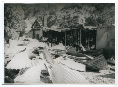 Orbost & District Historical Society
Photograph - Bemm River hotel fire
Bemm River is a small township in East Gippsland. There have been several Bemm River hotels since 1891 when the first Hotel was built by Henry Summer. This Hotel was located near a ford where traffic crossed the river. Annie Morgan was the next person to have a roadside licence to sell liquor at Bemm River, also known as Sydenham Inlet Hotel. In 1927, a hotel was built on the present site at Bemm River, again with the Morgan family. Like many hotels, the Bemm River hotel has burned down or suffered damage through fires and was rebuilt. These photos are likely of a fire at the Hotel in 1994 which resulted in the hotel burning down. It was re-built in 2000 on the same site.History of Bemm River and its hotel5 b/w photos showing a building with severe fire damage, and two people in front of the photos (probably owners).nonebemm river, fire, hotels -
 Wodonga & District Historical Society Inc
Album - Hume Reservoir Australia Album - Section of completed coffer dam, January 1927
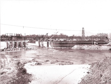
This set of photos is from a leather bound album bearing the inscription "HUME RESERVOIR AUSTRALIA" plus 'The Rt. Hon. L. C. M. S. Amery, P. C., M .P.' all inscribed in gold. It was presented to The Rt. Hon. L. C. M. S. Amery, P. C., M. P, Secretary of State for Dominion Affairs on the occasion of his visit to the Hume Reservoir on 2nd November 1927. This album is of local and national significance as it documents the planning and development of the Hume Reservoir up to 1927. It was the largest water reservoir in the British Empire. The album records the pioneering engineering work that went into its construction.DEPARTMENT OF PUBLIC WORKS, N.S.W. RIVER MURRAY WATERS SCHEME. HUME RESERVOIR. 20. Section of completed coffer dam with river diverted over the concrete foundations of dam that were placed during the first stage of operations. New South Wales. January 1927. Cofferdams are temporary structures used where construction is being carried out in areas submerged in water. They are most commonly used to facilitate the construction or repair of dams, piers and bridges. To divert the river, a Coffer Dam was built across the old bed above and below the Dam site and tying into the end of the concrete wall built inside the levee bank. This completely surrounded the remainder of the site of the Dam and south wing wall, including an area of 12½ acres. hume reservoir australia, river murray waters scheme, hume reservoir construction -
 Eltham District Historical Society Inc
Negative - Photograph, J.A. McDonald, Eltham-Yarra Glen Road, Lower Plenty footbridge, Sep. 1955
Tony Carberry and J. Jolly The Eltham-Yarra Glen Road as designated originated at the Shire of Eltham boundary at the Plenty River. West of the river the road was known as the Heidelberg-Eltham Road. The section from the Plenty River is now known as Lower Plenty Road which becomes Main Road. The footbridge no longer exists but was originally sited to the south, adjacent to the old Lower Plenty Bridge, now part of the Plenty River Trail. Record of various Shire of Eltham infrastructure works undertaken during the period of 1952-1962 involving bridge and road reconstruction projects, sometimes with Eltham Shire Council Project Reference numbers quoted. It was during this period that a number of significant improvements were made to roads and new bridges constructed within the shire that remain in place as of present day (2022). In many situations, the photos provide a tangible visible record of infrastructure that existed throughout the early days of the Shire. The album was put together by or under the direction of the Shire Engineer, J.A. McDonald.1955-09, eltham-yarra glen road, lower plenty footbridge, j. jolly, lower plenty, lower plenty bridge, lower plenty road, main road, plenty river trail, tony carberry, bridge construction, infrastructure, shire of eltham -
 Bendigo Historical Society Inc.
Document - STATE RIVERS AND WATER SUPPLY COMMISSION : CONSTITUTION AND FUNCTIONS
State Rivers and Water Supply Commission. Five page typed foolscap document, stapled, outlining the organisation's constitution and functions. The specific functions mentioned include Storage, Irrigation, Drainage - Flood Protection, Town Water Supply - Trust and Urban, Sewerage, Control, Crown's Rights, 1969 Groundwater Act, River Gauging’s, Survey and Research, Finance, Overseas Work, and Payroll (3500 employees). The document is undated, though some of the statistics given are from 1969.state infrastructure, water supply, coliban system, state rivers and water supply commission. coliban system. -
 Kew Historical Society Inc
Photograph - Yarra River, Kew, 1925
Henry Beater Christian (1886-1962) , was a descendant of one of the earliest settler families in Kew. Employed at the Kew Asylum as a 'public servant', he was a skilled amateur photographer, photographing numerous scenes in Kew and on his travels around Victoria. The majority of his photographs date from 1916 to 1929. His finest photographs are housed in two photograph albums. Digital copy of a photograph from page 3 of the 47-page photograph album containing 261 gelatinous silver images, loaned by Diane Washfold with permission given to digitise and hold a copy in our collection. A photograph of a stretch of the Yarra River at Kew. From the 1840s, at the Crown Land Sales, lots adjacent to the river were sold and developed as dairy farms, hence the presence of cattle until the land was subdivided or created into golf courses during the twentieth century. "Yarra Rvr / Kew / 1925"henry beater christian (1886-1962), landscape photography, kew (vic.) — yarra river, christian-washfold collection, photograph albums, dairying -- kew (vic.) -
 Kew Historical Society Inc
Photograph - Wharves and harbour on the Moyne River at Port Fairy, c.1926
Henry Beater Christian (1886-1962) , was a descendant of one of the earliest settler families in Kew. Employed at the Kew Asylum as a 'public servant', he was a skilled amateur photographer, photographing numerous scenes in Kew and on his travels around Victoria. The majority of his photographs date from 1916 to 1929. His finest photographs are housed in two photograph albums. Digital copy of a photograph from page 24 of the 47-page photograph album containing 261 gelatinous silver images, loaned by Diane Washfold with permission given to digitise and hold a copy in our collection. In what would appear to be one of his rare trips to coastal Victoria, Henry Christian took this photo of the wharves and harbour on the Moyne River at Port Fairy in c.1926. The photograph shows the buildings along the river and parts of the township in the distance. henry beater christian (1886-1962), landscape photography, christian-washfold collection, photograph albums, moyne river, port fairy (vic.) -
City of Kingston
Photograph - Colour, 29 January 1993
Bonbeach is a small beachside suburb located between Chelsea and Carrum. The station was opened in 1926 and was the last to be established in the group from Aspendale to Carrum. Urban growth began after World War II. State primary and high schools were opened in 1958 on land in Breeze Street that was once occupied by The Australian Glass Manufacturers. Immediately east of the school sites is the Patterson River Golf Club. The Bonbeach sports reserve has five ovals and is home to the Bonbeach football and baseball clubs. The suburb borders the Edithvale-Seaford Wetlands which is the remnant site of the Carrum Carrum swamp, once the home of the Bunurong people.Bonbeach was originally a seaside destination for holidaymakers and the housing comprised of holiday homes and gradually more permanent residents. It was not until 1926 that Bonbeach had its own railway station. From 1906 until the late 1940s sand was quarried on the east side of the railway line and used in the manufacture of glass. The Australian Glass Manufacturers sold this land in residential blocks and Bonbeach's permanent population spread from the coastal strip across to the other side of the railway line. Laminated colour aerial photograph of the suburb of Bonbeach and also the southern section of neighbouring Chelsea within the City of Kingston. The extent of this 1993 aerial image includes: Top left - Maury Road at the south end of the Chelsea shopping Centre; Top right - Scotch Parade Chelsea Bottom left - Monica Avenue in Bonbeach; Bottom right - Patterson River Golf Club. Landmarks include St Joseph's Church and Primary School, Chelsea Primary School, Bonbeach Station, Bonbeach Fotball Club sports playing fields and Bonbeach Life Saving Club. The Edithvale Wetlands is featured prominently to the right-hand side of the image. Black typed writing on white adhesive label: No. 6662 Black typed writing on white adhesive label: 26E/6662, 29/1/93, 4.25 pm Black typed writing on white adhesive label: 29-1-93 Black typed writing on white adhesive label: P000109 Circular yellow adhesive sticker bonbeach, chelsea -
 Greensborough Historical Society
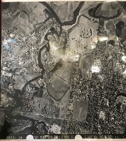
Aerial Photograph, Yan Yean M/S 7922 Run 17 No. 3833-18, 1/11/1984
Covers Viewbank area: North boundary Martin's Lane; South boundary Yarra River & Birrarung Park; East boundary east of Plenty RiverLaminated black and white aerial photograph; adjoins 6227 on west sideviewbank -
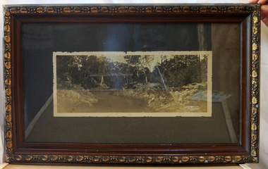 Orbost & District Historical Society
framed black and white photograph, C1920
Boggy Creek Bridge was built in 1916 as part of the Bairnsdale to Orbost extension to the main Gippsland Railway, and is situated in the middle of the township of Nowa Nowa, crossing a steep-sided and well-timbered creek-valley. This section of the line closed in 1987. This item is a pictorial record of the Boggy Creek railway bridge on the East Gippsland line. This bridge plays a major part in the identity and history of the town of Nowa Nowa, since Boggy Creek’s steep sided valley divides the township into two components.A black / white photograph of a bridge across a river in the bush. It is under glass in a brown wooden frame which has gold decorated edges. There appears to be a man sitting on rocks in the right front foreground.on front of photograph - "Nowa Nowa Creek, Gippsland, Victoria, Sears, Copyright"boggy-creek-nowa-nowa east-gippsland-railway bridge-rail -
Glenelg Shire Council Cultural Collection
Map - Map - Glenelg River, 1975
Laminated map, Glenelg River - Casterton, proposed flood level and lines to be designated. Photograph of map taken in 1975. Produced by Rural Water Commission to Shire Engineer, Casterton, attached to reverse of map.flood, flood levels, casterton -
Glenelg Shire Council Cultural Collection
Memorabilia - Stamp Set - Victoria's Centenary, c. 1934
Set of 3 stamps Centenary of Victoria 1934. Oblong stamps depicting Aborigine standing on banks of Yarra River, Melbourne on other sided. Red, 2D, blue 3D, black 1 shillingstamps, stamp set, 1934 -
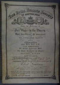 Victoria Police Museum
Certificate and Scroll (Robert Graham), 1888
Black embossed leather scroll with printed and handwritten Royal Humane Society Award Certificate awarded to Robert Graham for rescuing sufferers from the flood at the Goulburn River at Shepparton on 7th November 1887robert graham, greta, kelly gang, ellen kelly, royal humane society, bravery, awards, shepparton