Showing 3762 items
matching surveyed
-
 Kew Historical Society Inc
Plan - Subdivision Plan, Jas R Mathers Son & McMillan, Eastlawn Estate : East Kew Auction Sale, 1914
The Kew Historical Society's map collection includes a substantial number of real estate subdivision plans, mainly of Kew but also of surrounding suburbs in Melbourne. Most of the subdivision plans date from the 1920s and 1930s when the districts old homes and local farmland were being split up to accommodate residential growth in the postwar period. These early plans were assembled by a local firm, Jas R Mather & McMillan, which had an office in Cotham Road. Many of the plans, and sometimes photos, were annotated by the agents.Subdivision plans are historically important documents used as evidence for the growth of suburbs in Australia. They frequently provide information about when the land was sold as well as evidence relating to surveyors and real estate and financial agents. The numerous subdivision plans in the Kew Historical Society's collection represent working documents, ranging from the initial sketches made in planning a subdivision to printed plans on which auctioneers or agents listed the prices for which individual lots were sold. In a number of cases, the reverse of a subdivision plan in the collection includes a photograph of a house that was also for sale by the agent. These photographs provide significant heritage information relating house design and decoration, fencing and household gardens.The photograph may also be aesthetically significant depending on the importance of the photographic atelier.The ‘Eastlawn Estate’ was surveyed and ready for auction in March 1914, three months before the outbreak of World War I. Sixty-six allotments, created on the ‘order of Mr & Miss Preston’ surrounded the mansion of Woodlands in Harp Road. Woodlands formed part of the Estate, being advertised as lot 1. The allotments faced High, Station and Wright Streets, Harp and Normanby Roads, and Woodlands Avenue. Pru Sanderson in the Kew Conservation Study (Vol.2, 1988) wrote that the Eastlawn Estate ‘covered the western half of the failed Harp of Erin Estate’. Contemporary advertisements promoted the Eastlawn Estate as: ‘There will be no more convenient district nor pleasant Suburb than East Kew for the busy business man. When the Electric Tram is laid, he will be able to journey quickly and pleasantly direct from Collins Street to his home in the Eastlawn Estate in about 20 minutes’. The actual plans of subdivision were included in advertisements in The Argus and in the local newspapers."C" top left. Various annotations.subdivision plans - kew, station street, normanby road, high street, woodlands avenue, harp road, woodlands - kew -
 Kew Historical Society Inc
Plan - Subdivision Plan, Eastlawn Estate, 1914
Subdivision plans are historically important documents used as evidence of the growth of suburbs in Australia. They frequently provide information about when the land was sold on which a built structure was subsequently constructed as well as evidence relating to surveyors and real estate and financial agents. The numerous subdivision plans in the Kew Historical Society's collection represent working documents, ranging from the initial sketches made in planning a subdivision to printed plans on which auctioneers or agents listed the prices for which individual lots were sold. In a number of cases, the reverse of a subdivision plan in the collection includes a photograph of a house that was also for sale by the agent. These photographs provide significant heritage information relating house design and decoration, fencing and household gardens.The ‘Eastlawn Estate’ was surveyed and ready for auction in March 1914, three months before the outbreak of World War I. Sixty-six allotments, created on the ‘order of Mr & Miss Preston’ surrounded the mansion of Woodlands in Harp Road. Woodlands formed part of the Estate, being advertised as lot 1. The allotments faced High, Station and Wright Streets, Harp and Normanby Roads, and Woodlands Avenue. Pru Sanderson in the Kew Conservation Study (Vol.2, 1988) wrote that the Eastlawn Estate ‘covered the western half of the failed Harp of Erin Estate’. Contemporary advertisements promoted the Eastlawn Estate as: ‘There will be no more convenient district nor pleasant Suburb than East Kew for the busy business man. When the Electric Tram is laid, he will be able to journey quickly and pleasantly direct from Collins Street to his home in the Eastlawn Estate in about 20 minutes’. The actual plans of subdivision were included in advertisements in The Argus and in the local newspapers.subdivision plans - east kew, eastlawn estate -
 Port Melbourne Historical & Preservation Society
Document - Folders, Relating to City of Port Melbourne, 1988 - 1994
Six (6) folders of documents relating to the City of Port Melbourne as per attached list. .01 - two editions of Grapevine newslatter (May 1988 and April 1990) and eight editions of Port Council News (1988-1994) .02 - various letters, newspaper articles, etc; regarding unemployment in Port Melbourne during the Great Depression. .03 - Two surveys of Port Melbourne City Library services (1974/75 and 1990/91), various Book-Talk newsletters, Library News articles etc. .04 - Miscellaneous newspaper clippings re Port Melbourne City Library .05 - Architects Brief and Architects drawings for proposed new library in Liardet St 1986 .06 - various reports, mewspaper articles, correspondence, News Releases, minutes of "Preserve our Port" committee meetings, etc. All relating to the Victorian Governments efforts to carry out Council amalgamations in 1993/94local government - city of port melbourne, built environment - civic, amalgamation, port melbourne library -
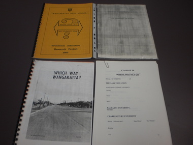 Wangaratta High School
WHS Student Pathway Reports, 1772-1885
Four booklets containing analyses of ex-student post-secondary education pathways. 1972: WHICH WAY WANGARATTA. A white bound booklet with a large black and white image of a Wangaratta street on the cover, analysing the pathways of students who graduated in 1972. 1983: WHERE HAVE ALL OUR STUDENTS GONE. A yellow bound transition education research project booklet with a WHS logo and a large double headed arrow and question mark symbol on the cover, analysing the pathways of students who graduated in 1983. 1987: WHY DO YOUNG PEOPLE LEAVE THE WANGARATTA REGION: A grey stapled booklet containing a WHS student survey report on the reasons young people leave the Wangaratta region after their secondary schooling 1994: CLASS OF 94. WHERE DID THEY GO: A white stapled booklet containing an analysis of WHS students graduating in 1994 and their post-secondary education pathways -
 Ballarat Tramway Museum
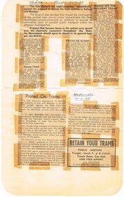
Newspaper, State Electricity Commission of Victoria (SEC) and The Courier Ballarat, Protest on trams, Mar. 1962
Yields information about the view of The Courier, and locals about the mooted closure of the tramway system and reporting on the proposal in particular local views and the setting up of the Save the Tramway Committee and a meeting.Foolscap sheet of plain paper, with rounded corners, with 5 newspaper cuttings, concerning the mooted closure of the Ballarat Tram system March 1962. All from The Courier, unless noted otherwise. 1 - Untitled - 6-3-62 - reporting on the Council's reaction to possible closure, emphatically against - will protest, seeking meeting and surveys. 2 - "Trams or buses?" - 6-3-62 - re replacement buses - would they provide the same service? 3 - "Hands off the Ballarat Trams" - 6-3-62 - by May Stath of Perth writing that would not catch a Geelong bus in case they got lost, waited at station to return to Ballarat by train, lamenting loss of Geelong and Perth trams. 4 - "Protest on Trams" - Editorial 7-3-62 - supporting Council's actions on the trams and promoting the idea that people should protest as well. 5 - "Retain your trams" - advert for a meeting 7/3/62 - Signed R. Courtney of the Union.closure, letter to the editor, editorial, sec -
 Melbourne Tram Museum
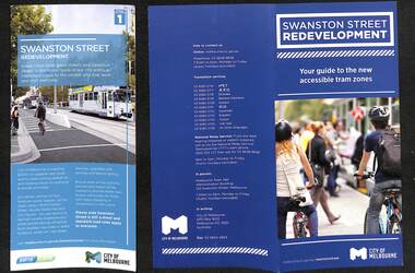
Pamphlet, VicRoads, "Swanston Street Proposed Tram Project", 2010 to 2011
Set of five pamphlets associated with the installation of Superstops with a bike path in Swanston St during 2010 and 2012. .1 - DL - General redevelopment - Stage 1 - general pamphlet, Published by City of Melbourne and Yarra Trams. 2 - DL - double fold - guide to the new accessible tram zones - City of Melbourne, mainly around the new bike lane arrangements. 3 - DL - tri fold - Information Update 1 - giving an outline of the proposed staging of the works, service changes and dates for works during 2011. Has logos for Yarra, VicRoads, State Government and think tram. 4 - DL - two fold - Tram service changes, for all Swanston St routes, May 2011 with a photo of C1 3525 on the front cover. 5 - DL - six fold - August 2010 - project survey, outlining project for Franklin St to Grattan St Carlton. Has logos for Yarra, VicRoads and think tram.trams, tramways, swanston st walk, swanston st, trackwork, city of melbourne, franklin st, carlton, proposals, tram 3525 -
 Bendigo Historical Society Inc.
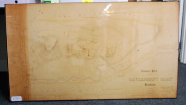
Map - CONTOUR PLAN OF THE GOVERNMENT CAMP SANDHURST 1854, 1994
Contour map (copy) of the Government Camp Sandhurst, 1854. Map is mounted on coreflute and laminated. Written in bottom righthand corner 'Contour Plan of the Government Camp, Sandhurst. Dec 1854. Signed by Richard Larritt, Assistant Surveyor, 11th December 1854.' Shown on map: Pall Mall, Bendigo Creek, Commissioner's Gully, View Place (now View Street), Post Office, Bank of Victoria, District Surgeon, Sandhurst Fire Brigade, Police Hospital, Flagstaff, Gold Office, License Shed, Military Barracks, Stables, Commissioner's Buildings, Police Office. Old Cemetery, Garden. Reference on righthand side: 'Stone or brick buildings are tinted in crimson. Wooden buildings tinted in Indian Ink. Tents and other temporary structures tinted in Burnt Sienna.' Scale of Chains, on bottom of map. Sticker on bottom left hand corner and back of map ' Presented by Survey and Mapping, Victoria, 7th Octber, 1994'.map, bendigo, government camp, pall mall, bendigo creek, commissioner's gully, view place (now view street), post office, bank of victoria, district surgeon, sandhurst fire brigade, police hospital, flagstaff, gold office, license shed, military barracks, stables, commissioner's buildings, police office. old cemetery, garden. , survey and mapping victoria. sandhurst, bendigo. -
 Bendigo Historical Society Inc.
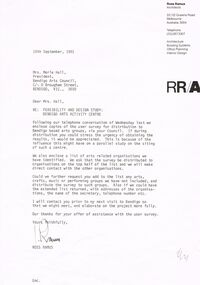
Document - MERLE HALL COLLECTION: DOCUMENTS RELATING TO FEASIBILITY OF BENDIGO ARTS CENTRE 1981 TO 1982
Various documents relating to feasibility of Bendigo Arts Centre 1981-1982: Correspondence re survey of potential user groups (Ross Ramus Architects) - two sites to be evaluated as part of that study - Central Bendigo site & BCAE, Flora Hill; Shire of Strathfieldsaye notification of proposed Bus Tour of performing arts centres in Melbourne; Reports of the Liaison Sub-Committee regarding Performing Arts Centre - minutes of meetings of 15/12/1981 and 22/4/1982; Revised List of User Groups per Bendigo Arts Council - addresses and names of Groups (some defunct); 9-paged document entitled ''History of Existing Policy'' covering history since the establishment in 1974 of the Regional Arts Centre Program - a Ministry for the Arts publication?) with details of state-wide commitments to thirteen arts centres - Bendigo having ''commitment in principle'' with four already in existence prior to the commencement of the program. -
 Bendigo Historical Society Inc.
Document - NORMAN OLIVER COLLECTION: SPEECH NOTES FROM YEARS 1949-1971
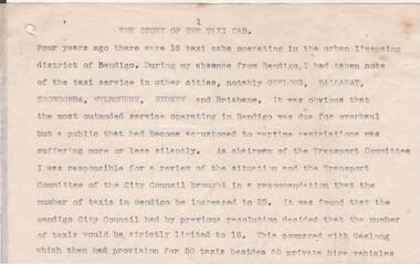
The Norman Oliver collection. Norman Oliver was three times Mayor of Bendigo - 1950-51, 1964-65, 1970-71. a) Seventeen pages of typed notes for a speech. Topics include : The story of the taxi cab, Your library, Regional library development, Land reclamation, Traffic control, A point about parking, Social (visit to Fortuna by Major General Brown Director of Ordnance survey, British Army), The historical society. Undated, but next to other notes marked 1951. b) a donation letter headed 'The Mayor Speaks' states: Herein are the texts of addresses given by the Mayor Cr N.J Oliver over Radio Station 3BO, together with other talks given by him. They were given to Alex H Stone by Mr Oliver on his leaving Bendigo. They are now handed by him to Bendigo Branch - Royal Historical Society of Victoria, as they are worthy of preservation. 26-3-1982 signed Alex H Stone.bendigo, council, speech notes, norman joseph oliver , councillor norman oliver, sometime mayor of bendigo. radio station 3bo 'the mayor speaks'. bendigo centenary 1951. -
 City of Moorabbin Historical Society (Operating the Box Cottage Museum)
Document,photocopy plan 'Two Acre Village 'c1852, c1960
In the 1852 Josiah Holloway, a developer, purchased 625 acres from the squatters Richard and John King and sectioned '2 acre allotments' south of Henry Dendy's Brighton Survey along the Arthur's Seat Road ( later Nepean Highway) for sale @ £10 It became known as The Two Acre Village as settlers took up the allotments and established market gardens, general stores, butchers, blacksmiths, post office and 2 hotels. Charles Whorral opened The Cheltenham Inn and it became so popular as a meeting place that the area was called Cheltenham. The early settlers, who were predominantly English and Scottish immigrants initially leased their allotments and, because the sandy soil was so fertile, they were soon able to purchase the land and increase their acreage. Cheltenham became a very important part of the large Moorabbin Shire1871 and City of Moorabbin 1934 In the 1994 Amalgamation of Councils, when the large City of Moorabbin was divided between the newly formed Glen Eira, Kingston and Bayside Councils, the Cheltenham area was assigned to the City of Kingston A photocopy of the Plan for the 2 Acre Village in Moorabbin Parish c1852. A3 laminatedmoorabbin, brighton, cheltenham, market gardeners, pioneers, early settlers, , king. john, holloway josiah, whorral charles, arthur’s seat road, nepean highway , cheltenham inn hotel, henry dendy special survey 1841 -
 City of Moorabbin Historical Society (Operating the Box Cottage Museum)
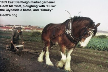
Photograph - Photograph: Horse-drawn Plough at Work, 1969 Geoff Marriott ploughing in his Market Garden, 1969
Members of the Marriott family arrived in Port Phillip in 1857. However it was John and Jane Marriott who in 1876, (after toiling hard since their arrival in1871, for very little gain), first leased, then purchased in 1882, 30 acres with a four-roomed house in East Boundary Road, in the area then called East Brighton. (Now known as East Bentleigh). The land they purchased had previously been a part of the 1841 Dendy Survey. Over the following years, John and his four sons with hard work and determination became prosperous vegetable growers and purchased further land in the area. Following John's retirement and subsequent death in 1903, the land was passed to his sons, and then onto the Marriott grandchildren. The family continued to remain very prosperous and successful vegetable growers. This lovely photo of Geoff Marriott bears testament to just one of the many families steeped in the tradition of vegetable growing which significantly contributed to the prosperity of the Shire, and its subsequent development into the City of Moorabbin. The photograph of Geoff Marriott of the Marriott family represents a typical example of the MANY early market gardening families, some names less prominent, but who with their labours contributed to the prosperity and the development of the community of the Shire of Moorabbin. This group of early pioneers, over many years, were a singularly important group responsible for the growth of schools, churches, the Mechanic's Hall, and were active in local government. Large coloured photograph, taken in 1969, showing Mr Geoff Marriott with his horse-drawn plough pulled by "Duke" the Clydesdale horse, and accompanied by "Smoky", his dog, working in his market garden, Brady Road, East Bentleighhorse, brighton, moorabbin, pioneers, settlers, fruit, markets, vegetables, plough, mayors, moorabbin shire, moorabbin roads board, marriott geoff, marriott john, marriott jane, market gardens, horse drawn plough, city of moorabbin -
 The Beechworth Burke Museum
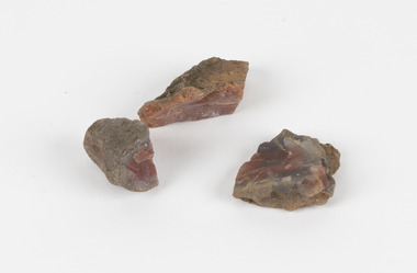
Geological specimen - Unknown, possible Carnelian Agate or Chalcedony
Although it is not known where these specimens were collected, Victoria and other regions of Australia were surveyed for sites of potential mineral wealth throughout the 19th Century. The identification of sites containing valuable commodities such as gold, iron ore and gemstones in a locality had the potential to shape the development and history of communities and industries in the area. The discovery of gold in Victoria, for instance, had a significant influence on the development of the area now known as 'the goldfields', including Beechworth; the city of Melbourne and Victoria as a whole. Agate occurs when amygdales (gas pockets) form in the upper levels of basaltic lava flows. If these pockets or bubbles are iniltrated by water bearing silica in solution, the fluid dries and hardens in layers, forming round or egg shaped nodules or geodes within the rocky matrix. Agate is formed of a silica mineral chalcedony similar to quartz. The term carnelian primarily refers to the reddish shading of the stone; whether the stone is termed an agate or chalcedony type is often influenced by the degree of colour banding the specimen shows. The specimens are significant as examples of surveying activity undertaken to assess and direct the development of the mineral resource industries in Victoria and Australia, as well as the movement to expand human knowledge of earth sciences such as mineralogy and geology in the nineteenth century.Three small geological specimens that appear visually consistent with images of rough or unpolished Carnelian Agate or Chalcedony. geological specimen, geology, geology collection, burke museum, beechworth, indigo shire, north-east victoria, gemstones, agate, carnelian -
 Orbost & District Historical Society
black and white photograph, late 19th century - early 20th century
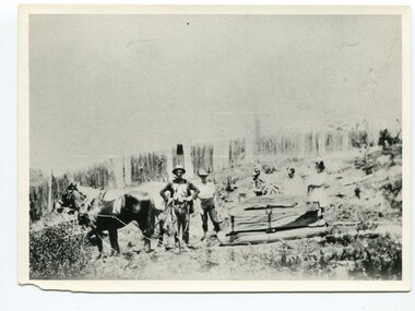
This photograph shows land clearing at Bendoc. From 1845 the Bendoc area was part of pastoral leases. In the 1850s alluvial gold was discovered in the Bendoc River. This was quickly exhausted, and a number of mines began successful reef operations. At the head of the river, the settlement of Clarkville clustered round several other mines. Many miners, including numbers of Chinese, sluiced the rivers. The population of the area was as high as 500 during this period. The township was surveyed in 1869 and the hotel built in 1870. This building was burnt down in the early 1900s and rebuilt. A school was also begun at this time. In the 1870s there was a decline in gold mining. Some miners selected land, which in many cases is still held by descendants. Dairying was common in the early days, supplying a butter factory at the New South Wales border, and a milk factory at Orbost in more recent times. Wheat was grown for the settlers' own use and ground at Bombala. Now beef cattle grazing is the main occupation. (info. from Victorian Places)This is a pictorial history associated with the early settlement of Bendoc in East Gippsland.A badly distorted black / white photograph of a horse drawn wagon, three men and two women clearing land.on back - "Clearing land at Bendoc"bendoc-land-clearing bendoc-early-settlement -
 The Beechworth Burke Museum
Photograph, est. 1860-1875
In 1875, the Rocky Mountain Extended Gold Sluicing Company Ltd was created, utilising the previous Rocky Mountain claim for the area near Lake Sambell. The company employed A.L Martin to survey an area for a tunnel underneath Beechworth and Johnson Stephens to dig it. The tunnel was built at a rate of 40 feet a month and eventually measured 800 metres. The tunnel was a true accomplishment both in the present and during the 19th century. It was considered to be a marvelous engineering feat. Beechworth is renowned for its hydraulic sluice method of mining. This involved soil being exposed to torrents of water from high-pressure hoses. From 1876 until its closure in 1921, the mine produced an astounding 47,926 ozs of gold. Companies like this were the source of income for many Chinese gold-diggers who sought to make their fortune on the goldfields of Beechworth. During the height of the rush, the town had around 7,000 Chinese inhabitants living on the outskirts of town as they were not permitted to live within Beechworth itself.The search for gold is ingrained into the history of Victoria and therefore, images like this one which portrays an open-cut sluicing site can reveal important information for society and technology for the date when the photograph was taken. This image is of important historical significance for its ability to convey information about sluicing and the methods used to find gold in 1910. It also shows a location where sluicing was undertaken which provides insight into the impact of sluicing on the environment at a time when it was done. This image of the Rocky Mountain mine is historically significant as the mining complex is now non-existent, with the only remains being the tunnel built in 1880 by the company, which was considered one of the greatest engineering feats of the time. The image also provides a first-hand look into the social and cultural networks at play during the 19th century with racial segregation of the Chinese at the 'Chinese Camp', as well as an insight into Beechworth's origins during the Gold Rush.A sepia rectangular photograph printed on matte photographic paper as a postcardReverse: Historic Beechworth / 7792.1 / ROCKY MOUNTAIN MINE / Viewed from the “Chinese Camp”, shown partly in the foreground, we see the central plant of the famous Rocky Mountain Mining Company. This extensive complex, of which nothing remains, was situated between Silver Creek and the present Lake Sambell area. The company was responsible for a tunnel cut through solid bedrock underneath the town of Beechworth and surfacing near the keystone bridge on the Wangaratta side. Completed in 1880 it was declared to be one of the greatest engineering feats in Australia. The tunnel is still basically intact today. / Series by Wooragee Graphics: Historic Beechworth. / COPYRIGHT BURKE MUSEUM / No.72 beechworth, rocky mountain mine, sluicing, gold rush, mining, gold -
 Warrnambool and District Historical Society Inc.
Chain link measure, Gunter's Chain, 19th Century
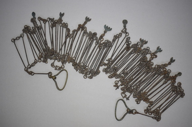
A Gunter’s Chain, an old land surveying instrument, is named after its inventor, Edmund Gunter (1581-1626), an English mathematician and astronomer. It was first produced in 1620. The tool has 100 links and is 66 feet or one chain long. The links are marked off in groups of ten by metal tags or rings. A quarter chain (25 links) is called a rod or pole and ten chains make a furlong and 80 chains a mile. The traditional cricket pitch is 22 yards or one chain long. This chain is said to have been used by Gilbert Nicol when the Warrnambool to Hamilton Road was constructed in the 19th century. Gilbert Nicol was an early settler in Warrnambool who, with John Craig, established the first hotel (and the first building) in Warrnambool in 1847. Nicol later owned the property ‘Rosehill’ in the Warrnambool area. As the chain was given to the Warrnambool and District Historical Society by the Town Clerk, Keith Arnel, it is likely that the chain was one of the items in the old Warrnambool MuseumThis Gunter’s Chain is of importance because it is an early land measuring device that was used for over 250 years and has great historical and mathematical significance. If it is correct that it was used by Gilbert Nicol when the Warrnambool to Hamilton Road was built then it has considerable local significance and dates back to the 19th century. This is a metal tool which consists of 100 metal pieces or links joined together by loops at each end with two metal loops in between each link. The links joined together form a chain. The two ends of the chain have small metal handles attached. At intervals along the chain there are additional rings or metal pieces attached. The metal is very rusted.gunter’s chain, land measurement tools, history of warrnambool -
 Warrnambool and District Historical Society Inc.
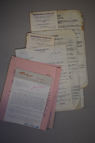
Document, Letters & Minutes, 1960s
These documents contain information about the Warrnambool Racing Club in the 1960s. Race meetings were held in Warrnambool as early as 1848, a few months after the first white settlers arrived. The Warrnambool Racing Club was formed in 1854 and the present day racecourse was first used in 1858. In 1872 the well-known Warrnambool Grand Annual Steeplechase was first held. These documents came from the office of Rolf Crawley, a surveyor, architect and engineer in private practice in Warrnambool and also the engineer for the Shire of Warrnambool from 1935 to 1968. His grandfather, father and uncle were also engineers, working in that capacity or as the Shire Secretary for the Shire of Warrnambool, with the Crawley family recording a total of 132 years of service to the Shire. The Shire of Warrnambool existed from 1863 to 1994. These documents came into the possession of Michael Hand who took over the private surveying practice in Warrnambool of Rolf Crawley. The Warrnambool and District Historical Society acquired these documents, along with several ledgers and other Crawley memorabilia, from the estate of Michael Hand. These documents are of interest as they contain much information on the Warrnambool Racing Club and will be of assistance to researchers.This is a collection of documents relating to the Warrnambool Racing Club. They are typewritten letters and Minutes summaries. Some are copies and there are two cards giving notice of meetings. rolf crawley, warrnambool, warrnambool racing club, shire of warrnambool -
Federation University Historical Collection
Booklet, Berry Anderson & Co, The Ballarat School of Mines, Calendar and Annual Report 1895, 1895
The Ballarat School of Mines Calendar and Annual Report 1895. Associateship of The School, Calendar for 1895, Certificates Granted by the Council 1894, Certificates Granted by the Education Department 1893, Comparative Statement of Receipts and Expenditure, Departmental Expenditure, Examiners, Examination Papers, Examination Fees, Fees, Honorary Correspondents, Life Governors, Meteorological Observations, Number of Students attended The School of Mines, Obituary, Office Bearers, Practical Treatment of Ores, Professors and Lecturers, Report of the Professor of Mineralogy and Geology and Curator of the Museum, Report of the Superintendent of Laboratories, Report of the Lecturer on Engineering and Surveying, Report of the Lecturer on Mathematics, Report of the Instructor in Engineering and Machine Construction and Design, Report of the Lecturer on Electrical Engineering, Report of the Lecturer on Geometrical Model and Perspective Drawing, Report of the Lecturer on Botany, Report of the Lecturer on Palaeontology, Materia Medica and Mining Ambulance, Scale of Charges for Assays and Analyses, Statement of Receipts and Expenditure for year 1894, Statistics - Student attending Lectures, Subscriptions and Donations, Syllabus of Lecture Courses, Time TableThe Ballarat School of Mines Calendar and Annual Report, 1895. Pale brown soft cover, 90 pages. ballarat school of mines, annual report, andrew anderson j.p. - president, f. j. martell - vice president, r. denham pinnock - vice president, the hon. sir w. j. clarke - trustee, the hon. john warrington rogers - trustee, the right reverend samuel thornton - trustee, andrew anderson - trustee, james millhinch - trustee, james oddie - trustee, the hon. henry cuthbert - honorary solicitor, r. g. middleton - honorary treasurer, charles kent - auditor, andrew berry - registrar, professor alf. mica smith - chemistry, metallurgy, natural philosophy, professor krause - geology, mineralogy, principles of mining, professor g. j. dawbarn - mine and land surveying, mining mechanics, hydraulics, civil engineering, applied mechanics, j. rowe - practical mining, j. a. dawson - electrical engineering, d. walker - chemistry and natural philosophy, w. e. bennett - mathematics, henry j. hall - freehand and perspective drawing, a. e. c. kerr - mechanical drawing (machine construction and design), george p. day - botany, e. gutheil - paleontology, zoology, materia medica, rivett henry bland - obituary, george gant scott - obituary, fiddian, bennett, r. allan, dawbarn, rosales, krause, joseph bryant, matthews, j. robinson, andrew robertson, john lynch, jonathan robinson, a.e.c. kerr, alfred mica smith, frederick mccoy, j. cosmo newberry, blackett, elelry, arnot, robert allan, bickett, kent, martin, mitchell, ferdinand von mueller, rivett henry bland, thomas bath, john rowe, museum, andrew anderson, george day, subscriptions and donations, examination papers -
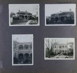 Glen Eira Historical Society
Album - Album page, Seymour Road, Circa 1972
This album was created in approximately 1972 as part of a project by the Caulfield Historical Society to assist in identifying buildings worthy of preservation. The album is related to a Survey the Caulfield Historical Society developed in collaboration with the National Trust of Australia (Victoria) and Caulfield City Council to identify historic buildings within the City of Caulfield that warranted the protection of a National Trust Classification. Principal photographer thought to be Trevor Hart, member of Caulfield Historical Society. Most photographs were taken between 1966-1972 with a small number of photographs being older and from unknown sources. All photographs are black and white except where stated, with 386 photographs over 198 pages. As at 22/08/2021, 51 Seymour Road is included in the HO179 Beemery Park Precinct which C204glen Amendment seeks to add to the Glen Eira Planning Scheme (amongst others). This is not yet finalised. Bellecourt (so named in 1989 according to Andrew Ward's Heritage Study) was originally named Beemery.Victorian Heritage Database HO62 Bellecourt 85 Seymour Road ELSTERNWICK https://vhd.heritagecouncil.vic.gov.au/places/35585 (as of 22/08/2021) "Beemery" at 85 Seymour Road, is an imposing ltalianate villa with arcaded asymmetrical facade built in 1891 for Charles Langdon. It has aesthetic, historical and social significance. Its aesthetic value rests with the facade which is highly representative of a not uncommon villa form of the late Victorian period. Its historical value derives from its association with the Langdon family in Caulfield (compare "Rosecraddock", "Tarqua" and "Hengar"). Its social value derives from its ability to demonstrate a lifestyle in late Victorian Caulfield.Page 190 of Photograph Album with four photographs of two different properties on Seymour Road.Handwritten: Seymour Road [top right] / 51 [under top left photo] / 51 [under top right photo] / 85 [under bottom left photo] / 85 [under bottom right photo] / 190 [bottom right]trevor hart, elsternwick, seymour road, late victorian, caulfield, beemery, bellecourt, house names, langdon family, charles langdon, cast iron work, verandahs, polychromatic brickwork, italianate style, arched balconies -
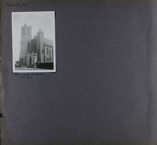 Glen Eira Historical Society
Album - Album page, Glen Huntly Road, Circa 1972
This photograph is part of the Caulfield Historical Album 1972. This album was created in approximately 1972 as part of a project by the Caulfield Historical Society to assist in identifying buildings worthy of preservation. The album is related to a Survey the Caulfield Historical Society developed in collaboration with the National Trust of Australia (Victoria) and Caulfield City Council to identify historic buildings within the City of Caulfield that warranted the protection of a National Trust Classification. Principal photographer thought to be Trevor Hart, member of Caulfield Historical Society. Most photographs were taken between 1966-1972 with a small number of photographs being older and from unknown sources. All photographs are black and white except where stated, with 386 photographs over 198 pages. From: Glen Eira Heritage Management Plan (1996) by Andrew Ward and Associates This Area is marked by the imposing brick and freestone gothic Revival church of the Holy Cross, built in 1937 to the design of O.H. Jorgensen. Church of the Holy Cross and Presbytery are contributory buildings to HO66.Page 65 of Photograph Album with one exterior photograph (landscape) of a brick church with a three storey tower.Hand written: Glenhuntly Rd [top left] / HOLY CROSS RC CHURCH / Dec 1972 [written underneath the photo] / 65 [bottom left] trevor hart, 1930's, gothic revival, brick, bell tower, spire, facade, catholic church, o h jorgensen, holy cross catholic church, caulfield, glenhuntly road, caulfield south, presbytery -
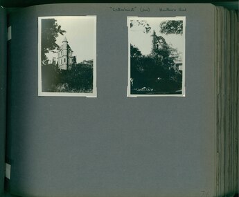 Glen Eira Historical Society
Album - Album page, Crotonhurst, Hawthorn Road, Circa 1972
This photograph is part of the Caulfield Historical Album 1972. This album was created in approximately 1972 as part of a project by the Caulfield Historical Society to assist in identifying buildings worthy of preservation. The album is related to a Survey the Caulfield Historical Society developed in collaboration with the National Trust of Australia (Victoria) and Caulfield City Council to identify historic buildings within the City of Caulfield that warranted the protection of a National Trust Classification. Principal photographer thought to be Trevor Hart, member of Caulfield Historical Society. Most photographs were taken between 1966-1972 with a small number of photographs being older and from unknown sources. All photographs are black and white except where stated, with 386 photographs over 198 pages. Dr Geulah Solomon's 4 volume book "Caulfield's Heritage" Vol 1 p 35 "...an elaborate double-storey spreading mansion which brought together several architectural styles to create a fairytale castle effect...". Dr Solomon indicates that the mansion was demolished circa 1937.Page 76 of Photograph Album with two portrait photographs of Crotonhurst and its grounds.Handwritten: "Crotonhust " (dem) Hawthorn Road [top right hand corner] / 76 [bottom right]trevor hart, caulfield, architectural features, architectural styles, hawthorn road, crotonhurst, north caulfield, gothic, george henry frederick webb, george webb, 1860's, judge webb, mansion, semi circular spire, square turret, cornish entrance porch, isabella webb, cruden farm, stables, castle-like towers, j mclaughlin, glen eira road, walworth avenue, stained glass windows, organs -
Bendigo Historical Society Inc.
Document - Mine Managers, a glimpse at a large subject. From Ballerstedt to Buerger
Mine managers had a variety of roles. They were a go-between for investors or shareholders and were responsible for the effective utilisation of human and physical resources above and underground. From the early 1870's the Bendigo school of mines held courses and exams leading to a Mine Manager's Certificate. These certificates were awarded in 3 classifications:- 1st class certificate holders could manage any mine where large and expensive machinery was used. They needed knowledge and competence in areas such as surveying, underground plan drawing, ventilation, amalgamation, retorting and smelting. They must also be literate and numerate. 2nd Class:- able to manage any mine where steam machinery was in use. 3rd Class:- for mines where there was no steam machinery . They needed to have a good knowledge of whim, whip or windlass work. Conversations continued through to the 1920's about whether the requirement for a Managers Certificate should be made compulsory under amendment to the Mines Act 1883. There were also discussions of the minimum amount of mine experience applicants should possess.A research paper detailing the history of managers and their role in the Bendigo gold fields. A short address prepared by James A. Lerk April/ May 2002. 8 pages.mine managers, ballerstedt, buerger -
 The Beechworth Burke Museum
Geological specimen - Basalt (igneous-volcanic) containing Olivine, unknown
This particular geological specimen was found in Mount Franklin or Lalgambook in Djadjawurrung, located between Daylesford and Newstead, approximately ninety minutes drive from Melbourne. The mountain is an example of a breached scoria cone (a steep conical hill of loose pyroclastic fragments) which was created by a volcanic eruption about 470,000 years ago, a date which may indicate the age of this geological specimen. The volcanic eruptions of Mount Franklin were most likely witnessed by members of the Dja Dja Wurrung Aboriginal tribe, who referred to this country as the 'smoking grounds'. Mount Franklin and the surrounding area appears to have been a place of considerable religious significance to Aboriginal people, there is evidence which indicates that frequent large ceremonial gatherings took place in the area. Basalt is the most common rock on Earth’s surface, more than 90% of all volcanic rock on Earth is basalt. Basalt is an aphanitic extrusive igneous rock formed from the rapid cooling of low-viscosity lava exposed at or very near the surface of a rocky planet or moon. Specimens are black in colour and weather to dark green or brown. Basalt is rich in iron and magnesium and is mainly composed of olivine, pyroxene, and plagioclase. Olivine is the name of a group of rock-forming silicate minerals with compositions ranging between Mg2SiO4 and Fe2SiO4. Unlike other minerals, Olivine has a very high crystallisation temperature which makes it the first of the minerals to crystallise from magma. As magma cools, the crystals begin to form and settle on the bottom of the lava and form basalts that are abnormally enriched in olivine in the lower part of lava flows. According to H. M. King (on geology.com) "Olivine is thought to be an important mineral in Earth's mantle. Its presence as a mantle mineral has been inferred by a change in the behaviour of seismic waves as they cross the boundary between Earth's crust and mantle". Lava from Mount Franklin and other volcanoes in the area filled valleys and buried the gold bearing streams that became the renowned ‘deep leads’ of the gold mining era. In 1852, as part of the Victorian gold rush, gold was discovered in the immediate area, this gold was created by lava flows during the Newer Volcanic period, which were mined intensively during the nineteenth century. Around 1865 the presence of a deep lead in Mount Franklin was established. Deep lead mining was initially unsuccessful, and it was not until the late 1870s that the Franklinford Gold Mining Company mined at Mount Franklin on a significant scale. A few years later the Mount Franklin Estate Gold Mining Company also struck gold, followed by the Shakespeare and Great Western companies in the mid-1880s. By the late 1880s, however, deep lead mining had ceased in the area. Soon after gold was discovered in 1851, Victoria’s Governor La Trobe wrote to the Colonial Office in London, urging ‘the propriety of selecting and appointing as Mineral Surveyor for this Colony a gentleman possessed of the requisite qualifications and acquaintance with geological science and phenomena’. Alfred Selwyn was appointed geological surveyor in Australia in 1852 which began the Geological Survey of Victoria. In 1853-69 the Geological Survey issued under Selwyn's direction sixty-one geological maps and numerous reports; they were of such high standard that a writer in the Quarterly Journal of the Geological Society of London bracketed the survey with that of the United States of America as the best in the world. During his years spent in Australia, Selwyn collected numerous significant geological specimens, examples of which are held in collections such as the Burke Museum.This geological specimen is an example of basalt and olivine which shows the volcanic lava activity and geographical specific nature of Mt Franklin as a significant volcanic site. According to Agriculture Victoria 'The crater is one of the deepest in the Central Highlands area. It is a major megacryst site with some of the largest known Victorian examples of megacrysts of augite and an orthoclase. The small parasitic mound of Lady Franklin on the western flanks adds to the geological interest of the site'. This specimen also highlights the locality as a significant place for both indigenous activity and Victorian gold rush era mining practices. This specimen is part of a larger collection of geological and mineral specimens collected from around Australia (and some parts of the world) and donated to the Burke Museum between 1868-1880. A large percentage of these specimens were collected in Victoria as part of the Geological Survey of Victoria that begun in 1852 (in response to the Gold Rush) to study and map the geology of Victoria. Collecting geological specimens was an important part of mapping and understanding the scientific makeup of the earth. Many of these specimens were sent to research and collecting organisations across Australia, including the Burke Museum, to educate and encourage further study.An angular, solid hand-sized piece of grey volcanic Basalt with green/brown Olivine phenocrysts along one flat edge.Olivine in basalt / - label is probably / correct. / C. Willman / 15/4/21burke museum, beechworth, indigo shire, beechworth museum, geological, geological specimen, mineralogy, basalt, igneous rock, igneous-volcanic, volcanic geology, volcanic, olivine, olivine specimen, basaltoid -
 Flagstaff Hill Maritime Museum and Village
Book, The Logbooks of The Lady Nelson, 1915
This hardcover book, The logbooks of the 'Lady Nelson' : with the journal of her first commander, Lieutenant James Grant, R.N., by Ida Lee (Mrs Charles Bruce Marriott) was published over 100 years after the Lady Nelson arrived in Australia to navigate and survey this ‘new colony’. Included in the book are sixteen charts and illustrations from the originals in the Admiralty Library, showing the surveyed land and water. The transcribed Contents, below, summarise the trips of the Lady Nelson during this time. Book’s Content PLUS text of the Chart of ‘Part of Bass Strait’ - Chapter 1: The Lady Nelson built with centreboards. Her voyage to Sydney under James Grant. The first ship to pass through Bass Strait. - Chapter 2: Returns to explore the Strait. Her visits to Jervis Bay and to Western Port in 1801 - Chapter 3: Colonel Paterson and Lieutenant Grant survey Hunter River - Chapter 4: Murray appointed commander of the Lady Nelson. His voyage to Norfolk Island. - Chapter 5: Murray’s exploration of Bass Strait. - Chapter 6: Discovery of Port Phillip. - Chapter 7: The Lady Nelson in company with HMS Investigator examines the North-Eastern shores of Australia. - Chapter 8: The French ships in Bass Strait. The founding of Hobart. - Chapter 9: Symons succeeds Curtoys as commander of the Lady Nelson. His voyages to Tasmania, Port Phillip and New Zealand. - Chapter 10: The Lady Nelson in Tasmania. The founding of Port Dalrymple. - Chapter 11: The Estramina is brought to Sydney. The Lady Nelson visits Norfolk Island and Port Dalrymple. - Chapter 12: Tippahee and his four sons are conveyed to New Zealand in the Lady Nelson. - Chapter 13: The Lady Nelson accompanies HMS Tamar to Melville Island. - Chapter 14: The loss of the Lady Nelson Text included with the ‘Chart of Bass Strait’ … “Part of Bass Strait, including the discoveries made by Acting Lieut. J. Murray, commander of His Majesty’s armed surveying vessel Lady Nelson, between November 1801 and March 1802. By command of His Excellency Governor King.” “This chart, which bears Murray’s autograph, shows his explorations of Western Port, Port Phillip and King Island. It should be noted that Flinders Island is named Grand Capuchin. This is one of the charts referred to as "unfortunately missing” in the Historical Records of N.S. Wales, vol. iv. P. 764” The story of the Lady Nelson In 1798 the British Admiralty ordered a cutter of 60 tons to be built along the design of the armed cutter Trial that was developed by Captain John Schanck, with three sliding keels or centreboards that could be individually raised and lowered, for use on the River Thames. The new cutter was to be named Lady Nelson. Philip Gidley King, prior to taking up his appointment as third Governor of the colony of New South Wales, was in England at the time of the Lady Nelson’s fit-out and was aware of the need for such a ship for survey work in the colony in New South Wales. He convinced Captain Schanck, the Commissioner of Transport in England, to construct and rig the Lady Nelson as a brig rather than a cutter, keeping the feature of the three sliding keels, which would be very useful for mapping in shallow waters. The new Lady Nelson was launched at Deptford, England on the River Thames in November 1798, with the official commission to discover and survey the unknown parts of the coast of New Holland (Australia) and establish British sovereignty over the continent. The Lady Nelson sailed from Portsmouth, England on March 1800 under the command of Lieutenant James Grant. She carried an armament of two original and four extra brass carronade carriage guns and set sail as part of a convoy heading to Port Jackson, in New South Wales, New Holland. After a while she continued to sail on her own. Her journey was troubled with problems at times; damaged and broken keels, troublesome crew and leaking topsides between the waterline and the deck due to poor seals. She arrived at the Cape of Good Hope in July and waited for the winter to pass to avoid the strong winds of the ‘Roaring Forties’. While at the Cape, Grant received a despatch to travel to Port Jackson via the newly discovered Bass Strait, rather than the usual route via the tip of Van Diemen’s Land (Tasmania). This also gave him the opportunity to survey the strait on the way. He departed the Cape in October and in December he made his first sighting of New Holland near Mount Gambier in what is now South Australia. A report by Ecclestone in 2012, ‘The Early Charting of Victoria’s Coastline’, mentions that Grant charted and named Capes Banks and Northumberland, and sighted inland hills that he named Mt Gambier and Mt Schanck, the latter after the designer of his ship. Grant then reached the south-western shores of what is now Victoria on 3-4 December 1800, and from Cape Bridgewater he examined the coast eastward to Cape Patton. Although he had not continuously sighted the coast in the vicinity of Port Fairy and Warrnambool, the western part of Victoria became known as Grant’s Land. The Lady Nelson continued eastward and passed through Bass Strait, becoming the first vessel to reach the east coast of New Holland from the west, and arrived at her destination of Port Jackson later in December 1800. Grant, in the Lady Nelson, then left Port Jackson and began survey work. He discovered Port Phillip on Victoria’s coast and explored King Island, he helped establish the first European settlement in Tasmania on the Derwent River, and Port Dalrymple, Newcastle and Port Macquarie. He made several trips from Norfolk Island to Hobart Town. Governor Macquarie sailed on with him to Van Diemen’s Land for a tour of inspection in 1811. Grant helped establish the first settlement on Melville Island in Northern Australia. The Lady Nelson was used to transport cargo, civilians and convicts and to source pigs from Timor. In February 1825 the Lady Nelson sailed again for Timor and never returned. One report said that “Every soul on board, we regret to state, was cruelly massacred, and the hull of the vessel was seen some time after with the name painted on her stern.” The hull was sighted on the island of Babar, which is almost 200 kilometres east of Timor. This particular copy of the book ... This item is from the ‘Pattison Collection’, a collection of books and records that was originally owned by the Warrnambool Mechanics’ Institute, which was founded in Warrnambool in 1853. By 1886 the Warrnambool Mechanics’ Institute (WMI) had grown to have a Library, Museum and Fine Arts Gallery, with a collection of “… choice productions of art, and valuable specimens in almost every branch and many wonderful national curiosities are now to be seen there, including historic relics of the town and district.” It later included a School of Design. Although it was very well patronised, the lack of financial support led the WMI in 1911 to ask the City Council to take it over. In 1935 Ralph Pattison was appointed as City Librarian to establish and organise the Warrnambool Library as it was then called. When the WMI building was pulled down in 1963 a new civic building was erected on the site and the new Warrnambool Library, on behalf of the City Council, took over all the holdings of the WMI. At this time some of the items were separated and identified as the ‘Pattison Collection’, named after Ralph Pattison. Eventually the components of the WMI were distributed from the Warrnambool Library to various places, including the Art Gallery, Historical Society and Flagstaff Hill. Later some were even distributed to other regional branches of Corangamite Regional Library and passed to and fro. It is difficult now to trace just where all of the items have ended up. The books at Flagstaff Hill Maritime Village generally display stamps and markings from Pattison as well as a variety of other institutions including the Mechanics’ Institute itself. RALPH ERIC PATTISON Ralph Eric Pattison was born in Rockhampton, Queensland, in 1891. He married Maude Swan from Warrnambool in 1920 and they set up home in Warrnambool. In 1935 Pattison accepted a position as City Librarian for the Warrnambool City Council. His huge challenge was to make a functional library within two rooms of the Mechanics’ Institute. He tirelessly cleaned, cleared and sorted a disarrayed collection of old books, jars of preserved specimens and other items reserved for exhibition in the city’s museum. He developed and updated the library with a wide variety of books for all tastes, including reference books for students; a difficult task to fulfil during the years following the Depression. He converted all of the lower area of the building into a library, reference room and reading room for members and the public. The books were sorted and stored using a cataloguing and card index system that he had developed himself. He also prepared the upper floor of the building and established the Art Gallery and later the Museum, a place to exhibit the many old relics that had been stored for years for this purpose. One of the treasures he found was a beautiful ancient clock, which he repaired, restored and enjoyed using in his office during the years of his service there. Ralph Pattison was described as “a meticulous gentleman whose punctuality, floorless courtesy and distinctive neat dress were hallmarks of his character, and ‘his’ clock controlled his daily routine, and his opening and closing of the library’s large heavy doors to the minute.” Pattison took leave during 1942 to 1945 to serve in the Royal Australian Navy, Volunteer Reserve as Lieutenant. A few years later he converted one of the Museum’s rooms into a Children’s Library, stocking it with suitable books for the younger generation. This was an instant success. In the 1950’s he had the honour of being appointed to the Victorian Library Board and received more inspiration from the monthly conferences in Melbourne. He was sadly retired in 1959 after over 23 years of service, due to the fact that he had gone over the working age of council officers. However he continued to take a very keen interest in the continual development of the Library until his death in 1969 This book about the logbooks of the Lady Nelson is locally significant for its association with the brig Lady Nelson, in which Lt. James Grant made the first documented European discovery of the area later known as Warrnambool in December 1800. This book is also nationally significant for its association with Grant in the Lady Nelson being the first to sail from west to east through Bass Strait, opening up a shorter, faster route to the colony of Port Jackson rather than going all the way south around Van Diemen’s Land. The book is nationally significant for its contents of the logbooks of the journeys of the Lady Nelson under various commanders and the copies of the charts created from the surveyed information and the new land of Australia was discovered. This book is also significant for its association with the full-size non-sailing replica of the Lady Nelson from Mount Gambier’s visitor centre, which was restored by Flagstaff Hill’s Master Boat Builder in Warrnambool in 2012, and with a ship mode of the Lady Nelson in our Collection The Pattison Collection, along with other items at Flagstaff Hill Maritime Village, was originally part of the Warrnambool Mechanics' Institute’s collection. The Warrnambool Mechanics’ Institute Collection is primarily significant in its totality, rather than for the individual objects it contains. Its contents are highly representative of the development of Mechanics' Institute libraries across Australia, particularly Victoria. A diversity of publications and themes has been amassed, and these provide clues to our understanding of the nature of and changes in the reading habits of Victorians from the 1850s to the middle of the 20th century. The collection also highlights the Warrnambool community’s commitment to the Mechanics’ Institute, reading, literacy and learning in the regions, and proves that access to knowledge was not impeded by distance. These items help to provide a more complete picture of our community’s ideals and aspirations. The Warrnambool Mechanics Institute book collection has historical and social significance for its strong association with the Mechanics Institute movement and the important role it played in the intellectual, cultural and social development of people throughout the latter part of the nineteenth century and the early twentieth century. The collection of books is a rare example of an early lending library and its significance is enhanced by the survival of an original collection of many volumes. The Warrnambool Mechanics' Institute’s publication collection is of both local and state significance. The Logbooks of The Lady Nelson Author: Ida Lee ( Mrs Charles Bruce Marriott) Publisher: Grafton & Co Date: 1915Label on spine with typed text RA 910.994 LEE Inside front cover has a sticker that reads Warrnambool Mechanics Institute and Free Library shipwrecked-coast, flagstaff-hill, warrnambool, flagstaff-hill-maritime-museum, maritime-museum, shipwreck-coast, flagstaff-hill-maritime-village, shipwrecked-artefact, book, warrnambool library, warrnambool mechanics’ institute, warrnambool city librarian, mechanics’ institute library, victorian library board, warrnambool books and records, warrnambool children’s library, great ocean road, the logbooks of the lady nelson, ida lee, mrs charles bruce marriott, captain john schanck, sliding keels or centreboards, lady nelson, british brig hms lady nelson, lieutennant james grant, bass strait discovery, surveying king island and port phillip bay, philip gidley king, survey map -
Bendigo Historical Society Inc.
Photograph - Aerial shots of parts of Bendigo 1934, 1934
AERIAL SHOTS OF PARTS OF BENDIGO 1934 Catalogue No.10584 This document contains scans of a unique set of aerial photographs that were taken over the City of Bendigo on Friday 12th January 1934, at about midday. The photographs were commissioned by Bendigo Mines Limited during their exploration and mining program designed to revitalize the Bendigo Goldfield. The photographs were given to the Victorian Mines Department sometime in the 1950s. The photographs were taken at a relatively low level of about 4000 feet. This gives a very detailed picture of Bendigo as it was in the 1930s. The photos cover the City Centre and are mainly of the goldfields on the south side of the city; the extent of which covers approximately the four corners of Myers Flat, Maiden Gully, Mandurang and One Tree Hill. Streets, roads and places of interest have been identified as best as possible in December 2023. There are 44 maps, and each references the adjoining maps.Typed Notes with CD The CD is one of two and contains a set of 46 images: The folder named "High_Resolution_800dpi" contains the original digital files that were produced by scanning the photographic prints (About A3 size) at 800 dpi using a high quality, large pformat, roll scanner. These files may be too large for some computers. A second CD contains a direstory called "Low_Resolution_300dep" The images in the folder names "Low_Reolution_300dpr" have a lower resolution (300 dpi) and have been rotated 90 degrees clockwise so that the Northern margin of each image is a the top of the screen. Clive Willman Senior Geologist Geological Survey of Victoriahistory, bendigo, bendigo mines, bendigo maps, bendigo aerial photos -
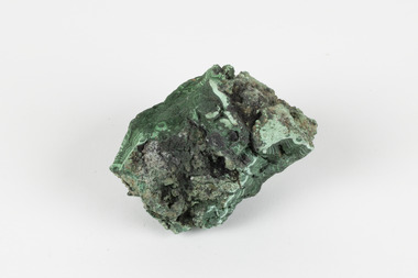 The Beechworth Burke Museum
Geological specimen - Malachite, Unknown
Malachite is a copper carbonate hydroxide mineral. It has a chemical composition of Cu2(CO3)(OH)2. It often forms within limestone where a subsurface chemical environment favourable for the formation of carbonate minerals can occur. It is a substance that can be found in many different parts of the world including: Australia, USA, Russia and the Democratic Republic of Congo. Malachite has historically been used to produce copper, with mining of the mineral dating back over a period of four thousand years. Due to its beautiful green colourations, it is also commonly used for aesthetic purposes such as in the production of sculptures and jewellery. This particular specimen was collected from the town of Burra, South Australia as part of a geological survey undertaken during the nineteenth century. The locality (located on Ngadjuri Country) has a long history of mining, particularly in copper mining, as the area is rich in copper deposits. The first significant discovery of this was made in Burra (Burra Burra Mine) in 1845 and, at the time, the mine was the largest and richest of its kind in the world, producing nearly five percent of the total world copper output. This specimen is significant as it is considered to be a rare gemstone, as many of the original deposits for the stones are significantly depleted, leaving behind very few sources. This specimen is part of a larger collection of geological and mineral specimens collected from around Australia (and some parts of the world) and donated to the Burke Museum between 1868-1880. A large percentage of these specimens were collected in Victoria as part of the Geological Survey of Victoria that begun in 1852 (in response to the Gold Rush) to study and map the geology of Victoria. Collecting geological specimens was an important part of mapping and understanding the scientific makeup of the earth. Many of these specimens were sent to research and collecting organisations across Australia, including the Burke Museum, to educate and encourage further study.A solid palm-sized copper carbonate hydroxide mineral with patterns of green colourations Existing Label: MALACHITE / Locality: Burra / S. Aust. Other Label: Confirmed / as Malachite / C. Willman / 15/4/1 / + Bill Birch burke museum, beechworth, geological, geological specimen, malachite, gemstone, green gemstone, burra, burra burra mine, burra south australia, carbonate mineral, copper, copper mining, copper mining burra, carbonate hydroxide mineral, copper carbonate, malachite mining, malachite burra, monster mine -
 Federation University Historical Collection
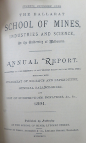
Booklet - Annual Report, The Ballarat School of Mines, Industries and Science, Annual Report 1891, 1891
The Ballarat School of Mines Annual Report 1891. Annual Report, Crown Grant, Affiliation Statute, Constitution, Examination Statutes, Associateship of The School, Certificates Granted by the Council, Clunes Branch Report, Departmental Expenditure, Fees, Form of Bequest, Gauge-Testing Apparatus, General Balance Sheet and Liabilities and Assets, Honorary Correspondents, Life Governors, Meteorological Observations, Number of Students attended The School of Mines, Office Bearers, Practical Treatment of Ores, Report of the Professor of Mineralogy and Geology and Curator of the Museum, Report of the Superintendent of Laboratories, Report of the Lecturer on Engineering and Surveying, Report of the Lecturer on Mathematics, Report of the Lecturer on Electrical Engineering and Telegraphy, Report of the Lecturer on Botany, Report of the Lecturer on Geometrical and Freehand Drawing, Report of the Lecturer on Materia Medica and Physiology, Report of University Classes, Report on Mining Laboratory, Examinations Held, Scale of Charges for Assays and Analyses, Statement of Receipts and Expenditure for the year 1891 and Special Trust Funds, Statistics - Students attending Lectures, Subjects and Lecturers, Subjects and Examiners, Subscriptions and Donations from 1st January to 31st December 1891, Syllabus of Lecture CoursesThe Ballarat School of Mines Industries and Science Annual Report, 1891. Cover is browning around the edges, front cover has small tear on bottom of cover, 132 pages. ballarat school of mines, annual report, andrew anderson j.p. - president, f. j. martell - vice president, r. denham pinnock - vice president, rivett henry bland - trustee, the hon. sir w. j. clarke - trustee, the hon. john warrington rogers - trustee, james oddie - trustee, the hon. henry cuthbert - honorary solicitor, c. eyres - honorary treasurer, charles kent - auditor, andrew berry - registrar, f. m. krause - professor of mineralogy and geology, and curator of the museum, alf. mica. smith - chemistry, metallurgy, natural philosophy, f. m. krause - geology, mineralogy, geological surveying, j. h. horwood - lecturer on engineering and surveying, h. j. hall - lecturer free-hand and model drawing, george day - botany, j. f. usher - materia medica and physiology, c. w. wilson - university classes, isaac jaques jones j.p., mr e. wattis - manager, mining laboratory, j. a. dawson - electrical engineering and telegraphy, elder gray, harry e. sando, charles matthews - auditor, j. h. daley - auditor, henry crone - assistant registrar of titles, henry b. loch, isaac jacques jones, charles eyres, j.a, j.a. dawson, statistics, university classes, bella guerin, c.w. wilson, clunes branch of the ballarat school of mines, w.e. burbridge, h.j. hall, museum, state school students, daniel walker, a.j. higgins, state school science classes -
 Federation University Historical Collection
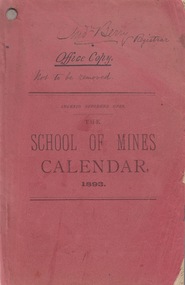
Booklet, The Ballarat School of Mines, Industries and Science, Calendar and Annual Report 1893, 1893
The Ballarat School of Mines Annual Report 1893. Annual Report, Examination Papers, Associateship of The School of Mines, Syllabus for Technical Schools, Crown Grant, Affiliation Statute, Certificates Granted by the Council, Clunes Branch Report, Departmental Expenditure, Fees, Form of Bequest, General Balance Sheet and Liabilities and Assets, Honorary Correspondents, Life Governors, Meteorological Observations, Number of Students attended The School of Mines, Office Bearers, Practical Treatment of Ores, Report of the Professor of Mineralogy and Geology and Curator of the Museum, Report of the Superintendent of Laboratories, Report of the Lecturer on Engineering and Surveying, Report of the Lecturer on Mathematics, Report of the Lecturer in Mechanical Drawing, Machine Construction and Design, Report of the Lecturer on Electrical Engineering and Telegraphy, Report of the Lecturer on Botany, Report of the Lecturer on Biology, Pharmacy, Materia Medica, Report on Mining Laboratory, Examinations Held, Scale of Charges for Assays and Analyses, Statement of Receipts and Expenditure for the year 1892 and Special Trust Funds, Statistics - Students attending Lectures, Subjects and Lecturers, Subjects and Examiners, Subscriptions and Donations from 1st January to 31st December 1892, Syllabus of Lecture Courses6188: The Ballarat School of Mines Industries and Science Calendar and Annual Report, 1893. Red soft cover is browning around the edges, spine is tattered, 156 pages. 6188.2: Red soft covered booklet of 26 pages, Office Copyballarat school of mines, annual report, andrew anderson j.p. - president, f. j. martell - vice president, r. denham pinnock - vice president, rivett henry bland - trustee, the hon. sir w. j. clarke - trustee, the hon. john warrington rogers - trustee, james oddie - trustee, the hon. henry cuthbert - honorary solicitor, r. g. middleton - honorary treasurer, charles kent - auditor, andrew berry - registrar, alf. mica. smith - chemistry, metallurgy, f. m. krause - geology, mineralogy, mining, j. h. horwood - mechanical engineering, machine drawing and design, theoretica and applied mechanics, mathematics, henry j. hall - freehand and model drawing, j. a. dawson - electricity and magnetism, george day - botany, e. gutheil - biology, materia medica, pharmacy, a. e. c. kerr - mechanical drawing, machine construction and design, e. gutheil - biology, pharmacy, materia medica, henry crone - assistant registrar of titles, henry b. loch, elder gray - president, clunes branch, harry e. sando - registrar, clunes branch, w. y. witherden - hon. treasurer, clunes branch -
 The Beechworth Burke Museum
Photograph - Photograph - Reproduction
The photograph is a reproduction of a postcard from the Rocky Mountain Mining Company. In 1875, the Rocky Mountain Extended Gold Sluicing Company Ltd was created, utilising the previous Rocky Mountain claim for the area near Lake Sambell. The company employed A.L Martin to survey an area for a tunnel underneath Beechworth and Johnson Stephens to dig it. The tunnel was built at a rate of 40 feet a month and eventually measured 800 metres. The tunnel was a true accomplishment both in the present and during the 19th century. It was considered to be a marvelous engineering feat. Beechworth is renowned for its hydraulic sluice method of mining. This involved soil being exposed to torrents of water from high-pressure hoses. From 1876 until its closure in 1921, the mine produced an astounding 47,926 ozs of gold. Companies like this were the source of income for many Chinese gold-diggers who sought to make their fortune on the goldfields of Beechworth. During the height of the rush, the town had around 7,000 Chinese inhabitants living on the outskirts of town as they were not permitted to live within Beechworth itself.This image of the Rocky Mountain mine is historically significant as the mining complex is now non-existent, with the only remains being the tunnel built in 1880 by the company, which was considered one of the greatest engineering feats of the time. The image also provides a first-hand look into the social and cultural networks at play during the 19th century with racial segregation of the Chinese at the 'Chinese Camp', as well as an insight into Beechworth's origins during the Gold Rush.Black and white rectangular reproduced photograph printed on paperbeechworth, rocky mountain mine, sluicing, gold rush, mining, gold -
Federation University Historical Collection
Booklet, Berry Anderson & Co, The Ballarat School of Mines, Calendar and Annual Report 1894, 1894
The Ballarat School of Mines Calendar and Annual Report 1894. Associateship of The School, Calendar for 1894, Certificates Granted by the Council 1893, Comparative Statement of Receipts and Expenditure, Departmental Expenditure, Examiners, Examination Papers, Examination Fees, Fees, Honorary Correspondents, Life Governors, Meteorological Observations, Mining Engineering Scholarship, Number of Certificates Granted since Inception, Number of Students attended The School of Mines, Office Bearers, Plant and Appliances, Practical Treatment of Ores, Professors and Lecturers, Report of the Professor of Mineralogy and Geology and Curator of the Museum, Report of the Superintendent of Laboratories, Report of the Lecturer on Engineering and Surveying, Report of the Lecturer on Mathematics, Report of the Instructor in Mechanical Drawing and Machine Construction and Design, Report of the Lecturer on Electrical Engineering and Telegraphy, Report of the Lecturer on Geometrical Model and Perspective Drawing, Report of the Lecturer on Botany, Report of the Lecturer on Biology, Pharmacy, Materia Medica, Scale of Charges for Assays and Analyses, State School Science Classes, Statement of Receipts and Expenditure for year 1893 and Serjeant Scholarship Fund, Statistics - Student attending Lectures, Subscriptions and Donations, Syllabus of Lecture Courses, Time TableThe Ballarat School of Mines Calendar and Annual Report, 1894. Green soft cover, 116 pages. ballarat school of mines, annual report, andrew anderson j.p. - president, f. j. martell - vice president, r. denham pinnock - vice president, rivett henry bland - trustee, the hon. sir w. j. clarke - trustee, the hon. john warrington rogers - trustee, james oddie - trustee, the hon. henry cuthbert - honorary solicitor, r. g. middleton - honorary treasurer, charles kent - auditor, andrew berry - registrar, professor alf. mica smith - chemistry, metallurgy, natural philosophy, professor krause - geology, mineralogy, principles of mining, professor j. h. horwood - mine and land surveying, mining mechanics, hydraulics, civil engineering, applied mechanics, j. a. dawson - electrical engineering, d. walker - chemistry and natural philosophy, w. e. bennetts - mathematics, henry j. hall - freehand and perspective drawing, a. e. c. kerr - mechanical drawing, george p. day - botany, e. gutheil - paleontology, zoology, materia medica, w. d. snowball - veterinary science -
 Running Rabbits Military Museum operated by the Upwey Belgrave RSL Sub Branch
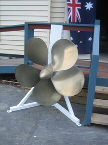
Propeller from HMAS Bayonet, Walkers Ltd
Bayonet was one of 20 Attack class patrol boats built for the Royal Australian Navy between 1967 and 1969 by Walkers Ltd of Maryborough Qld . In the 1960s, Australia became more closely involved in events in the Asia-Pacific region. This led to improved surveillance and control of our enormous coastline, especially the northern approaches. Patrol boats controlled illegal fishing, smuggling and immigration, search and rescue, and occasional inshore survey work. Her hull is steel and the superstructure is aluminium. It is armed for small-scale encounters, with one 40-mm Bofors gun and two 0.5-inch Browning machine guns to fire warning shots across the bow of a suspect vessel. She was 32.6 m long and 6.1 m wide, 150 tons, powered by two paxman diesel engines and capable of about 24 knots. . A sister ship featured in the popular ABC-TV series Patrol Boat. The Bayonet conducted patrol duties around Australian waters until her scuttling by defence maritime services on 21 September 1999 in 82 m of water off Torquay in Victoria. propeller, hmas bayonet