Showing 14239 items
matching printed photographs
-
 Kiewa Valley Historical Society
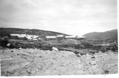
Photographs – Set of 9 black and white photographs and photocopies of original photographs depicting the early days of Bogong Village during the 1940’s, circa 1940's
Bogong Village, which was known as “The Junction”, is well recorded. The first tent camp was at the junction of Pretty Valley and Rocky Valley streams in the early 40’s. Further downstream were the sawmill, stables and blacksmith’s forge. Horses were the main mode of transport in the early days. The road to Bogong had reached the lookout spur just beyond Roper’s Spur track just before the 1939 fires. The early forties saw rapid growth of the village, with single and married men’s quarters, workshops, mess huts and administrative offices. The facilities necessary for communal living were quickly in place- a post office, police station, co-op store, medical centre, community hall/theatre, tennis courts and school. Much of the temporary accommodation that housed groups such as the Albion Quarrying Company were in the area now under water.Pictorial history of the early years of Bogong Village including one photo taken following the devastating fires of 1939. Photos show the terrain in which Bogong Village was built, the early construction used for the temporary buildings and the housing and the amount of infrastructure required to accommodate the needs of the residents of the area including workers, their families and other support staff. Set of 9 black and white photographs and photocopies of photographs depicting early buildings at Bogong Village . Photos show very early construction buildings as well as the village in various weather conditions, including snowing and after bush fires. (some official SECV photographs) 1. Bogong Village in heavy snow 2. Bogong Township during heavy snow (SECV Official Photo) 3. VIP Lodge at Bogong in the snow 4. Bogong Village - circa 1940’s 5. Bogong Village under street lights 6. Lewis Construction Camp (SECV Official Photo) 7. Albion Quarrying Co. Camp (SECV Official Photo) 8. Tent camp and early buildings following 1939 fires 9. Typical house – Bogong Village 1. Handwritten under photo – August 1948 2. Printed under photo: STATE ELECTRICITY COMMISSION OF VICTORIA Date: 25.8.48 Time: 9am No:K 4680 Kiewa Hydro-Electric Works. Bogong Township 3. Handwritten on back of photo- V.I.P. Lodge, Bogong 4 – 5. No markings 6. Printed under photo: STATE ELECTRICITY COMMISSION OF VICTORIA Date: 28.11.40 Time: 1.40pm No:K284 Kiewa Hydro-Electric Works. Lewis Construction Camp 7. Printed under photo: STATE ELECTRICITY COMMISSION OF VICTORIA Date: 11.1.41 Time: 10.40am No:K294 Kiewa Hydro-Electric Works. Albion Quarrying Co. Camp – Bogong. Handwritten on back of photo: On the floor of the present dam 8. No markings 9. Printed under photo: STATE ELECTRICITY COMMISSION OF VICTORIA Date: 11.1.46 Time: 1.23pm No:K2181 Kiewa Hydro-Electric Works. Bogong – Typical House bogong village; 1939 fires; kiewa hydro electric scheme; -
 Kiewa Valley Historical Society
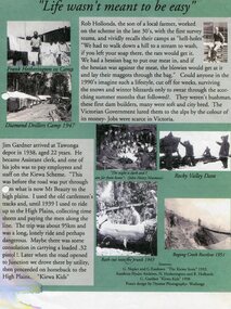
Posters – Set of 3 A4 posters depicting the early days and people in the Kiewa Valley
In the 1830’s, European pastoralists started moving south from NSW into the Alps. In 1836, cattle grazing began around Omeo and the runs spread out into the foothills. The higher country was used for summer grazing and huts were built for shelter and storage during stock mustering. The lure of gold brought many people to the Alps from around 1850 to 1900. Bushfires destroyed the forests around Melbourne in 1939 and the boom in house-building after World War II ked to increased demand for timber from the Alps. This resulted in the building of a network of roads which helped open up access to the Alps. The early 1940’s brought the first of many workers to the Alps for the planning and construction of the Hydro-Electric Scheme. These were the pioneers and early settlers of the Kiewa Valley and provided a wealth of characters and a tapestry of stories and adventures to be handed down to future generations.These 3 posters, which were most likely produced for promotional purposes provide a glimpse into the early lives of the pioneer families of the Kiewa Valley through pictures and verse. They show their lifestyle and outline the hardships they had to endure in living and working in the Alpine region. They also highlight the early arguments regarding grazing in the high country which would ultimately lead to the end of the long traditions of the high country cattle men. Set of 3 A4 size posters with black and white photographs and text and colour background depicting various parts of the history of the Kiewa Valley. 1. Titled - ‘Life wasn’t meant to be easy’ Describes early life for Kiewa Hydro workers. 2. Titled - ‘Cattlemen of the High Plains’ Describes a brief history of life of the cattlemen of the high plains 3. Titled – ‘There are Places I’ll remember’ Depicts early photographs of residents of the Kiewa Valley, also includes the words from a John Lennon song as per poster title. Printed on each poster – Poster designed by Dyanne Photography - Wodonga 1. Printed at bottom of poster – Sources: G Napier and G Easdown “The Kiewa Story” 1993. Southern Hydro Archives, N Hetherington and R Hollands. G Gardner “The Kiewa Kids” 1998. 2. Printed at bottom of poster – Sources: D Purland. Handwritten at top of poster- Poster 4 3. Printed at bottom of poster – Sources: B Roper, W Davies, D Higginson, H Ryder. Handwritten at top of poster- Poster 3 kiewa valley; tourism; lifestyles -
 Kiewa Valley Historical Society
11 Black and White photographs of the Rocky Valley area, c1948
In October 1947 construction was commenced on the erection of the workmen's camp at Rocky Valley. Also in 1947 construction of a stream diversion was commenced to allow excavation to commence for the dam wall. In the summer of 1948/49, stripping of the foundation area on both sides of the river was carried out. Weather conditions were not always favourable during the construction, particularly 1955/56 summer, and work would have to cease each year for the winter season due to the severe conditions. The dam is a earth and rock fill structure with a height of about 30.5 metres and crest length 518.16 metres and was completed in March, 1959.These photographs show the type of terrain in the area prior to the construction and filling of Rocky Valley Dam. Also of interest is the type of accommodation provided for those working on the construction and the early cranes available in the 1940/50's. Of historical importance to understand the conditions in the early construction of the Kiewa Hydro Electric SchemeEleven small black and white photographsPhoto No. 1 - on the back, printed in ink"Rocky Valley - New Mess & offices Dec. 1948". In pencil '14 on the back Photo No. 2 - on the back, printed in ink "Rocky Valley Camp. October 1948". Also stamped on the back "998L" Photo No. 3 -on the back, printed in ink "Rocky Valley Hostel October 1948". Also stamped on the back '998L' Photo No. 4 - on the back, printed in ink "Spion Kopje from bedroom window. October 1948". Stamped on the back '998L'. Photo No. 5 - on the back, printed in ink "Rocky Valley Basin Dec. 1948." In pencil on back, 14. Photo No. 6 - on the back, printed in ink "Site of Wall for Rocky Valley Dam Dec. 1948". In pencil on back, 14. Photo No. 7 - On the back, printed in ink "Commencing of Diversion Tunnel Rocky Valley December 1948". In pencil on back, 14. Photo No. 8 - on the back, printed in ink "One of the two electric cranes at Rocky Valley December 1948". In pencil on back, 14. Photo No. 9 - on the back, printed in ink "'Rapier' (H.Y.) electric crane Rocky Valley December 1948". In pencil on back, 14 . Photo No. 10 - on the back, printed in ink " Pretty Valley Pump line construction Mt. Cope in Background Nov 1948. Circular stamp with the words 'print by Wilson White Albury' in the circle. Photo No. 11 - on the back, printed in ink "Stringing cable on Ruined Castle October 1948. Same stamp as No. 10. In pencil '31'. rocky valley; pretty valley; ruined castle; bogong high plains; kiewa hydro electric scheme -
 Kiewa Valley Historical Society
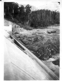
12 small black and white photgraphs of Junction Dam and surrounding area, Photo No. 1 c1940, all others c 1948
Junction Dam is a reinforced slab and buttress type construction and was commenced in February, 1940 by Lewis Construction Company. Stiff leg derricks were erected at appropriate locations at the site of the dam and used for the disposal of excavated material and the placing of concrete. A rock crushing and screening plant was established at a site a short distance upstream from the dam site and concrete was supplied from a central mixing plant placed close to the upstream toe of the structure. The SEC took over the construction in April 1942 and the dam wall was completed in March, 1944. Bogong township was commenced in early 1940 with the construction of a workmen's camp housing 96 men, (known as Junction camp). Construction of housing for families commenced shortly after. Forty houses, plus office, workshops, stores and laboratory accommodation were completed over the next 5 years,Of historical significance as a pictorial record of Junction Dam, Lake Guy and Bogong Village, as the photos were taken only 4 years after completion and one photo taken on completion of the dam wall but before the lake was filled with water.12 small black and white photographs of Junction Dam, Bogong Village and surrounding area.Photo 1 - On the back upper edge in pen 'Junction Dam'. Then '12' in pencil, circular stamp, printed in centre 'Print by Willson White Albury'. Photo 2 - On the back upper edge in pen 'Junction Dam October 1948'. Stamp as no. 1 photo. Stamp '998L' lower centre. Photo 3 - on the back upper edge in pen 'Junction Dam October 1948'. Circular stamp with 'Kodak Print' . Lower centre back is stamped 'velox' and '998L'. Photo 4 - upper back, in ink - 'Junction Dam Spion Kopje in background. October 1948'. Stamps as photo no. 4. Photo 5 - upper back, in ink - 'Lake Guy (orange filter) October 1948'. Centre back, in pencil '29' and circular stamp with words 'Print by Willson White Albury'. Photo 6 - upper back edge 'Junction, Bogong from Radio Receiving Shack Dec. 1948'. In pencil '14'. Photo 7 - On back of photo 'View of Mountains from Little Arthur Fire Track October 1948'. Two circular stamps with 'Kodak Print', another two stamps - 'Velox' and '998L'. Photo 8 - On back in ink 'Loone's Store Bogong with Spion Kopje in background. October 1948'. Lower down, stamps 'Velox' and '998L'. Part of circular stamp with one word 'Kodak'. Photo 9 - on back in ink 'Junction Camp, Bogong Village & Lake Guy from Little Arthur Fire Track. October 1948'. Stamped across writing '998L'. Lower down stamped 'Velox' and circular stamp with words 'Kodak Print'. Photo 10 - on back in ink 'Junction Camp & Bogong Village Lake Guy in Foreground. October 1948'. Stamps as photo 9. Photo 11 - on back in ink 'Junction Camp & Bogong Village, Lake Guy in Foreground. October 1948'. Lower stamp '998L'. Photo 12 - 'Junction of Rocky & Pretty Rivers with tennis courts in foreground October 1948' . Circular stamp with words, 'Print by Willson White Albury'. Number '29' written pencil.junction dam; bogong village; kiewa hydro electric scheme; lake guy -
 Kiewa Valley Historical Society
7 small black and white photographs of Pretty Valley, c1948
In 1947 it was proposed to construct a dam on the Pretty Valley branch of the East Kiewa River. This was part of the initial planning in 1937. The Pretty Valley Reservoir was to be part of a pumped-storage scheme with a pumping station located immediately below the main structure. Preparatory work was commenced in 1946 with erection of staff accommodation. Between 1947 and 1950 the main camp was erected, access roads, constructed and banks and benches at the dam site undertaken. Following the financial crisis in 1951, a review of the scheme was carried out and work ceased in June 1951. Construction of the dam was deleted from the programme of works and all buildings removed.A pictorial history of part of the initial planning in 1937 for a dam to be constructed at Pretty Valley as part of the Kiewa Hydro Electric Scheme.7 small black and white photographs of Pretty ValleyAll photos have a circular stamp on the back with 'Print by Willson White Albury' enclosed. Photo 1 - on the back, handwritten in ink 'New 22Kv pump line - Pretty Valley Nov. 1948'. In pencil '18'. Photo 2 - On the back, handwritten in ink 'Pretty Valley - Staff mess on right Nov. 1948'. In pencil '18'. Photo 3 - On the back, handwritten in ink 'Pretty Valley Basin - looking S.E. Nov. 1948'. In pencil '5'. Photo 4 - On the back, handwritten in ink 'New pump 22Kv line, Pretty Valley - looking towards Mt. Mackie. Nov. 1948'. In pencil '5'. Photo 5 - On the back, handwritten in ink 'Pretty Valley. Mt. Cope just out of picture extreme right. Nov. 1948'. In pencil '78'. Photo 6 - on the back, handwritten in ink 'View from Pretty Valley Ruined Castle in Background Nov. 1948'. In pencil '78'. Photo 7 - on the back, handwritten in ink 'Pretty Valley Pump line (Nov. 1948)'. In pencil'78'.construct, dam, pretty valley -
 Kiewa Valley Historical Society
5 small black and white photos of Clover Dam and Power Station, c1948
The construction of Clover Power Station was commenced in October 1942 and the power station building was completed in May, 1943. The first machine was placed in service August, 1944 and the second machine in May, 1945. The water discharges directly into Clover Dam and re-used in West Kiewa Station. Clover Dam - stripping of foundation area commenced in January 1948 but the final concrete pour was not until 14th August, 1954.Pictorial history of the early construction undertaken in the building of the Kiewa Hydro Electric Scheme. Clover power station (No. 3 Development) was the first power station to be built .5 small black and white photographsPhoto No. 1 - handwritten in ink on back ' No. 3 Power Station Clover Flat Nov. 1948 Photo No. 2 - handwritten in ink on back 'No. 3 Power Station Clover Flat Nov. 1948 Photo No. 3- handwritten in ink 'Clover Flat looking towards work area of Clover Dam. Taken near #3 PS. Nov. 1948 Photo No 4 - Handwritten in ink 'Preparation for wall of Clover Dam Dec. 1948 Photo No.5 - handwritten in ink 'Preparation for wall o f Clover Dam Dec. 1948. Photo Nos. 1,2 3, on the back have circular stamp with 'Print by Willson White Albury'. In pencil is the number '78'. Photo Nos. 4, 5, have written on the back in pencil, number '14'. construction, clover power station, clover dam, -
 Kiewa Valley Historical Society
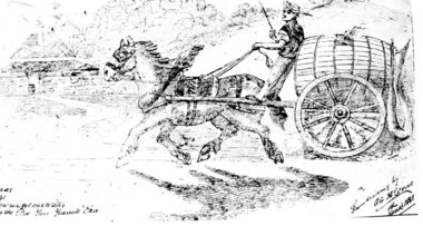
Postcard – Black and white illustration of horse and cart with driver, Circa 1881
Postcard production blossomed in the late 1800s and early 1900s. Postcards were popular because they were a quick and easy way for individuals to communicate with each other and became an efficient method of sharing information and photographs.Postcards provided a glimpse into the lifestyles of the sender which sometimes included a photograph of family or a hand drawn scene as in the accompanying example. As such, they formed part of family history.Black and white printed postcard of a hand drawn single horse cart with driver. Cart is carrying a large wooden barrel with hose attached. Brick homestead building in background. Unwritten on the rear. Handwritten inscription on bottom left of page - How we got our water in the pre Yan Yeanite era Handwritten inscription on bottom right of page – From drawing by G. G. McCrae Christmas 1881 postcard; horse and cart; -
 Kiewa Valley Historical Society
Photograph - Photographs x 13 - Cattlemen
11 of the 13 photos were taken by Tor Holth and used in his book "Cattlemen of the High Country" first published in 1980. Co writer was Jane Holth (Barnaby). Of the other two photos, one was taken by C. Roper (2 old gentlemen of the High Plains) and the other (Fred Roper, Tom Hollonds, Kyran Marum - early cattlemen) unknown photographer. The book tells the story of the lives of the mountain cattlemen of Victoria's high country, the harsh conditions and challenges they faced when they mustered their cattle before winter to bring them down to lower pastures. Huts were built of any materials available and were scattered about the high plains to provide shelter from the elements. Some are still standing despite the many bushfires that have ravaged the area.The photographs are of historic significance as they are of early pioneers in the cattle industry in the Kiewa Valley. The huts are of significant interest as they show different types of construction and materials as does the cattle yard at Bogong Jack's. All 13 photos are black and white and printed on photographic paper and are of varying size. 1.On the back, hand written in pencil - "Bogong Jacks hut on Fainter Spur". 2.15 in top right hand corner and 120% centre of photo and circled. 2.On the back a typewritten label cut out and fixed with sticky tape "45 b.&w. Cope Hut, known also as the Menzies of the high plains." Lower left corner is a handwritten label, written in red biro, COPE HUT (underlined) V circled and Journeys into History. 3. Top right hand corner '2.32(a) and across the back, written in pencil, 'Wallace's Hut 1976' and 'TOR HOLTH' in red biro on small sticker lower R corner. 4.2.32(c) in pencil top R corner. 'Wallaces Hut 1976' in pencil across back of photo. 5. '42.7a' in pencil top R corner. Written in pencil across back of photo 'Remains of the second Tawanga Hut.' 6. 'Jim Edmundson Mt. Beauty' handwritten in blue biro across back of photo. 7. '2.26' in pencil top R corner. 'Cattle yard at Bogong Jack's' handwritten in blue biro across back of photo. 8. 'Jim Edmondson of Edmondsons hut' written in pencil on back of photo. 9. 'Geoff Wallace Kergunyah' written in pencil on back of photo. 10.' Geoff Wallace Kergunyah' handwritten in pencil on back of photo. 11. 2.11 in pencil top R corner. 'Fred Roper & Jack Platt. Ph. C.Roper' handwritten in orange pen and under, in pencil, '2 old gentlemen of the High Plains.' 12. Written in black pen across back of photo 'Left to right Fred Roper, Tom Hollonds, Kyran Marum - early cattlemen' 13. Hand written on back of photo 'Sid Ryder' photos, cattlemen, high plains, huts -
 Kiewa Valley Historical Society
Maps - Bogong x2, Tawonga, Omeo, Dargo, Victoria and others, 1. Bogong Alpine Area; 2. Bogong 8324; 3. Tawonga Topographical; 4. Omeo 8433; 5. Dargo 8323; 6. Victoria State
1. Bogong Alpine Area (outdoor Leisure Map. survey & Mapping Victoria, Government of Victoria, Edition 2, reprinted 1991 with an image of Mt. Feathertop on the front. Information for tourist in the Alpine National Park: Bogong Area. Including: recreational activities, history, weather and vegetation and a list of walks together with locality maps and photographs. The front cover has an image of Mt Feathertop against a blue sky with yellow writing 'Bogong Alpine Area', there is a yellow triangular block on the right hand top corner with black writing 'Outdoor Leisure Map. On the bottom edge is a block of yellow with black writing 'Survey & Mapping Victoria' and a light green map of Victoria with 'VICMSP' printed in white. 2. 8324 Bogong Victoria, Edition 1, Commonwealth of Australia 1981. A topographical Map: 1:100,000 scale (1 cm to 1 KM). Map has a red cover with white writing together with a white block and black writing and a map insert. 3. Tawonga Topographical Map - Forests Commission Victoria, / revised 5/9/77, DEG No. 68-G/399. A Tawonga 803 folded map in a beige colour with the back blank. 4. Omeo 8433 Victoria, Edition 1, Department of Natural Resources. The map has a red and white cover with black writing and a simple map of Australia at the bottom. 5. 8323 Dargo, Edition 1, Commonwealth of Australia. A red and white cover with a map insert. 6. Victoria State Map, Hema Maps, 2002. Hema Maps, State Map, colourful cover with a map of Australia and four tourism photographs. Scale 1: 850,000 An inscription handwritten in blue pen "Trappers Gap to Mitta Mitta 1" to 1 mile". There are some pen markings and notations of tracks.maps, bogong, omeo, tawonga, dargo, victoria, bogong alpine area -
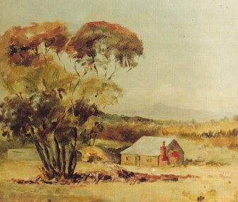
 Ringwood and District Historical Society
Photograph, Kenneth Marshall, Ringwood Lake c.1960, circa 1960
Framed silver gelatin printNotation on back - "Ken Marshall, Jeweller, Maroondah Highway Ringwood took this photo. It was displayed in his shop window when I bought it. Next door to Pratt the butcher and Ron Dickason's fruiterer, just prior to the Eastland development - Gloria Welch, 23 Campbell St. Ringwood East." -
 Ringwood and District Historical Society
Photograph, Ringwood State School No.2997, Maroondah Highway, Ringwood (corner of Ringwood Street) - c.1900
Sepia Photograph, also B&W large print. Mr. Hocking (left), was Headmaster 1898-1917.No inscription -
 Ringwood and District Historical Society
Photograph, Foundation stone for Ringwood State School No. 2997, laid by Mrs. J.K. Turnbull on 15th August, 1889
Photograph of Foundation stone for Ringwood State School No. 2997 was laid by Mrs. J.K. Turnbull on 15th August, 1889, marking the opening of the school situated in Whitehorse Road at the corner of Ringwood Street (1889-1922). Mrs. Turnbull was the wife of the Ringwood Station Master. The stone was removed after the school closed in 1922 and re-laid in 1962 by the School Committee at this subsequent Greenwood Avenue school site and is pictured here being viewed near the entrance in 1973 by Mr. Ron Pullin, Archivist, Ringwood Historical Research Group".Sign below photograph reads, "Foundation stone of Ringwood State School (late Ringwood St.). Now in grounds of Greenwood Avenue Ringwood State School". Inscription on stone, "This foundation stone was laid by Mrs. J.K. Turnbull on 15th August 1889". Printed on plaque below stone, "No.2997 - Ringwood State School 1889-1922. Situated in Ringwood Street, East Side sixty yards north of Maroondah Highway. Foundation stone removed 19?? re-erected by the School Committee 1962". -
 Ringwood and District Historical Society
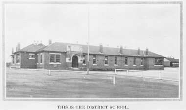
Photograph, Ringwood State School photograph for land sale - Charm-View Estate, Heathmont - 1926
Printed below picture, "This is the district school". Written on back of photograph, "Photo taken from Sub. Div. Plan Land Sale Charm-View Estate, Heathmont. 1926?" -
 Ringwood and District Historical Society
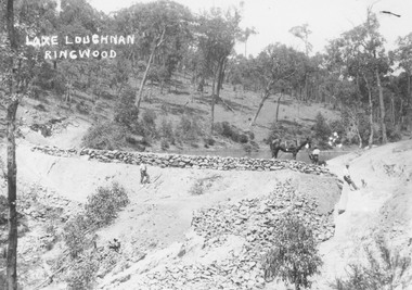
Photograph, Lake Loughnan Ringwood - Recreational Man-mad lake(undated)
Typed below one of photographs, "Recreational man made lake on north side of Loughnans Hill. It was the local swimming hole. Was in Werac Drive gully beyond Kubis Drive." Printed on photo "Lake Loughnan Ringwood" -
 Ringwood and District Historical Society
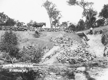
Photograph, Building the recreational man-made lake on the north side of Loughnans Hill: "Lake Loughnan". (Undated)
Printed on photo "Lake Loughnan Ringwood"Typed below photograph, "Building the recreational man-made lake on the north side of Loughnans Hill. It was the local swimming hole in Werac Drive gully beyond Kubis Drive. Now site of a new housing estate." Written on Photo "Lake Loughnan Ringwood" -
 Ringwood and District Historical Society
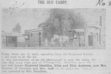
Photograph, 1950 newspaper clipping featuring circa 1920 photograph of Mr William Hussey and his horse-drawn cab at Ringwood Railway Station, with Hilda and Elsie Anderson standing near the horses
Ringwood Mail newspaper clipping - 7/12/50. Heading of article, "The old cabby". Printed below picture, "Today there are 11 taxis operating from the Ringwood Station. 1 cab used to do the lot. In this reproduction of an old photograph is seen the cabby, Mr.Hussey who died some time ago at Warrandyte. Standing near the horses are two well known Ringwood identities, Hilda and Elsie Anderson, now Mrs. Morcom, of Croydon, and Mrs. Addi..., of Ringwood. The newsagency was operated by Mrs. Hamilton". -
 Ringwood and District Historical Society
Photograph, Painting by Mrs. Miles of the first mine manager's cottage at mine site, East Ringwood. (No record of date)
Catalogue card reads, "Print of oil painting done by Mrs. Miles of first miners cottage used for mine manager". Written on back of picture, "Painting by Mrs. Miles of the first mine manager's cottage at mine site, East Ringwood. He was relative of Edith Gluth who lent the painting for photo copying". -
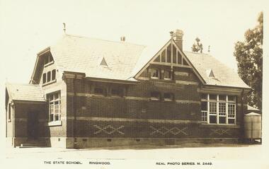 Ringwood and District Historical Society
Photograph, Postcard image of Ringwood State School, cnr Maroondah Hwy and Ringwood Street, Ringwood - 1910 & 1921
Written on backing sheet, "Ringwood St. Site now occupied by Coles shop and store". Printed below postcard, "The State School. Ringwood. Real Photo Series. M. 2449". -
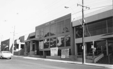 Ringwood and District Historical Society
Photographs, Ringwood Street, Ringwood. 1984 (11 views)
Buildings/Business in photos include Abacus House, Social Security building, Spectacle Makers, Ross Print, AMP, Westpac, Holt & MacDonald, Dance Club, Arthur Young &Co Chartered AccountantsWritten on back of photographs, "Ringwood Street, 1984." -
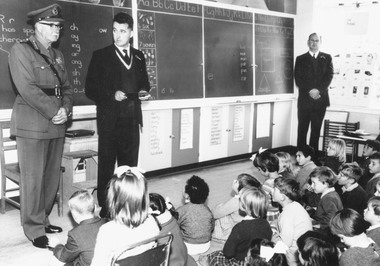 Ringwood and District Historical Society
Photograph, Major General Beavis visiting North Ringwood State School, Oban Road, to commemorate 10th anniversary of Memorial Tree planting - 1965
Typed below both pictures, 'Major General Beavis placing new plaque on Memorial Tree, North Ringwood State School 1965'. Printed on backing sheet, 'North Ringwood State School. Major Gen. Beavis and new plaque to tree 1965. North Ringwood State School 11/11/65. See Mail 18/11/65'. (Mr. A. Moten, Headmaster) -
 Ringwood and District Historical Society
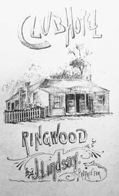
Photograph, Club Hotel - 1889
Black and white print of drawing of Club Hotel.Written around photograph, Club Hotel, Ringwood. J.L. Lindsay, Proprietor". Typed below, "Club Hotel - 1889". -
 Ringwood and District Historical Society
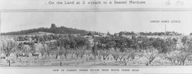
Photograph, Image used for land auction promotion of Garden Homes Estate between Mullum Mullum Road, Ringwood and Mullum Mullum Creek - 20/10/1923 , later developed to include The Centreway, Wattle Crescent, and Reserve Crescent, Ringwood
Black and white photograph of picture from subdivisional brochure. Picture shows orchard in foreground with a hill towards background. Treed area in the middle with a few houses scattered amongst them. To right of picture is printed, "Garden Homes Estate" with an arrow pointing to land. Printed above picture, "On the Land at 3 o'clock in a Seated Marquee. Typed below picture, "View of Gard -
 Ringwood and District Historical Society
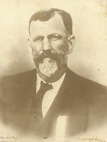
Photograph, Jack Hann, Ringwood's first ranger (undated)
... ranger. Very active in local affairs". Printed at bottom... Road Ringwood North melbourne Photograph Jack Hann, Ringwood's ...Written on backing sheet, "Jack Hann, Ringwood's first ranger. Very active in local affairs". Printed at bottom of photograph, "Copied by - Borlington/Melb." -
 Ringwood and District Historical Society
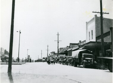
Photograph, Main Street Ringwood, looking east late 1940's
Black and white photograph of Main Street, Ringwood. Clock tower in background in original position. (2 copies) Catalogue card reads, "Whitehorse Rd. looking east - south side 1935. Station entrance just past Carter's on right". Looking East from Whitehorse Rd, not 1935, late 1940s?, 2 copiesTyped below photograph, "Main St. Looking East. Railway Station entrance on right past Carter's - 1935". Small, original print has Main St c1949" written on back. -
 Ringwood and District Historical Society
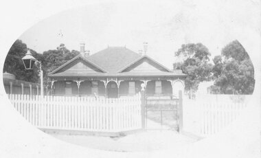
Photograph, Ringwood Hospital ("The Pines") Adelaide St. (Undated)
Black and white photograph, oval shaped. Subject is a building with two peaks of roof-line at front. Front of building has veranda and a picket fence is at front with a lantern in foreground. Printed on the photo is, "Ringwood Hospital". (3 copies - 1 original postcard print and 2 enlargements).Typed below photograph, "The old 'Pines' Hospital in Adelaide Street. Now Eastland site. Many older Ringwood residents born there." -
 Ringwood and District Historical Society
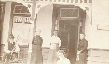
Photograph, left to right - Mr. Carr, Mrs. Carr, Mrs. Dulfer, Miss Bould, Miss Grant. (no date)
Inscription on the sepia post card print reads, "left to right - Mr. Carr, Mrs. Carr, Mrs. Dulfer, Miss Bould, Miss Grant. -
 Ringwood and District Historical Society
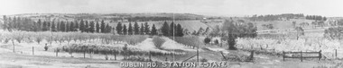
Photograph, Dublin Rd. Station Estate brochure. c.1923
Printed on picture, "Dublin Rd. Station Estate" . Written below picture, "c1923". -
 Ringwood and District Historical Society
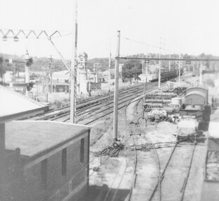
Photograph, Ringwood railway station precinct. Easterly view from pedestrian overpass c.1948
Accompanying printed sheet reads, "Taken a few minutes after the previous picture shows the Croydon train arriving. Also in this picture you can see the wooden pole supporting the wiring bridge over the goods yard. This was another temporary resulting from the June 1945 accident. -
 Orbost & District Historical Society
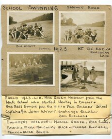
black and white photographs, 1923
These are photographs of students at the Orbost Higher Elementary School in 1923. They were taken at the Snaggers Lane end of the Snowy River. with the students is teacher, Miss Wyatt. In the photograph, bottom right, from L-R are Miss Gwen Hobson from the Orbost state School who started hockey in Orbost; Miss Bessie Goudie from the Higher Elementary School, Pen Gilbert, school captain, Miss Jean Wyatt an exchange teacher from England. the swimmers include Muriel Grose; Vera Swan; Annie and Myra Malcolm, Alice and Florrie Boucher and Mollie and Alice Hammil. During 1910-11 the first approaches were made to the Department for the establishment of a HES in Orbost and this became a reality in 1912. Orbost HES supplied post-primary education in the district until a high school was built in 1948.Orbost High School / Orbost Secondary College has played a significant part in the education of senior students in the Orbost district . It is the sole senior educational institution. This item is representative of its history. Four black / white photographs pasted onto grey cardboard. each is labelled - had-written in black print. A label is attached to the bottom of the card. Two of the photographs are of groups of students wearing swimming costumes sitting on a river bank A teacher is with them holding an open umbrella. Another photograph is of a group of students in swimming costumed standing in water. The other is of four women sitting on a large tree log in front of a wooden building.at top - "SCHOOL SWIMMING SNOWY RIVER" There are hand-written labels under the photographs and a list of names attached to the bottom with metal paper clips.education-orbost orbost-higher-elementary-school swimming-carnival -
 Orbost & District Historical Society
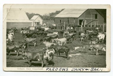
black and white photograph/ poscards, Vogt. W.S, C1890 - 1920
Edward James Pardew died in 26/9/1927 aged 92. He came to Orbost from New Zealand in 1886 and selected 720 acres of hill land in the Brodribb area. He was a member of the first Orbost Shire Council. His daughter had a fruit & meat shop in McLeod Street. He was an inaugural vestryman of St James Church of England. One of the most prominent farmers on the Snowy was John Gilbert, a large landowner. His breeding establishment was at Tullagoota, about two and a half kilometres down the river from Orbost.Dairying in the Orbost district was once a mainstay of the farming community. Today the properties are fewer and smaller.Two black / white photographs of dairy herds. 3188.1 - on front - printed -"ORBOST EAST GIPPSLAND"; hand-written - :PARDEWS DAIRY & BARN" 3188.2 - on front - printed - " W. S. VOGT"; hand-written - "DAIRY HERD TALLAGOOTA< ORBOST"dairying-orbost agriculture-orbost pardew-dairy tallagoota-dairy