Showing 4900 items
matching residents
-
 Port Melbourne Historical & Preservation Society
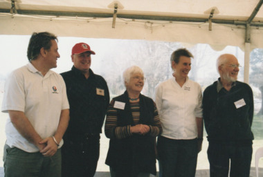
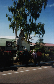
Photograph - Launch of History of a Street Precinct, 25 Sep
In 2005, members of the PMH&PS undertook a study of the residents of the houses in a Port Melbourne street precinct from the 1880s to 1960. The area is bounded by Evans Street, the E side of Bridge Street, S side of Williamstown Road, Farrell Street both the E & W sides plus the section of Ross Street between Farrell and Bridge and the part of Derham Street between Farrell and Bridge. The resulting map and an interactive CD won the Best Community Research, Registers & Records project at the 2007 Victorian Community History Awards. The project was launched on the railway reserve near the corner of Evans & Farrell streets. l - R - Mayor Darren RAY, David THOMPSON, Margaret BRIDE, Janet BOLITHO, Graham BRIDE.CoPP mayor and PMHPS members involved in the production at the launch of the History of a Street Precinct25/9/05 Mayor, David Thompson, Margaret Bride, Janet Bolitho, Graham Bridehistory of a street precinct, darren ray, graham bride, margaret bride, janet bolitho, david thompson -
 Warrnambool and District Historical Society Inc.
Administrative record (Collection) - Warrnambool Waterside Workers' Federation, John Esam, Warrnambool, Waterside Workers' Federation, Warrnambool Branch, 1902-1955
Donated to the Warrnambool & District Historical Society by John Esam, Secretary of the Warrnambool Waterside Workers' Federation 1942-1950Administrative records and associated material held by the Warrnambool Waterside Workers' Federation to 1955Kept in W.D.H.S. Archives Room in Ledgers Section in archival boxSeven items of the Warrnambol Waterside Workers' Federation including Minute Books, Booklet containing Constitution and Rules, Membership records, Financial records and Correspondence re the dissolution of the Warrnambool branchwaterside workers in warrnambool, belfast & koroit steam navigation company, warrnambool waterside workers' federationwaterside workers in warrnambool, belfast & koroit steam navigation company, warrnambool waterside workers' federation -
 Eltham District Historical Society Inc
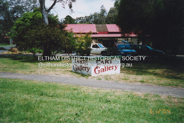
Photograph, Fay Bridge, Local humour added to Art Gallery sign, 559 Main Road, Eltham, 5 December 2004
Photo taken immediately after the Wiregrass gallery closed at the end of November. The property was purchased in October 2004 for $565,000 by a local investment company, Sentinel Equities run by local residents Jethro and Suzanne Still. Plans to redevelop the property into offices and a gallery designed by Robert Marshall and supported by a number of local artists met with opposition from Eltham Gateway Action Group in 2007 over the proposed new building size and insufficient parking provision given the proposed reliance on the VicRoads reserve on Main Road for parking. The development proposal was finally approved by VCAT in January 2008 subject to VicRoads approving the use of the road reserve for parking. That did not happen and the property remains undeveloped 15 years later (August 2023).fay bridge collection, 559 main road eltham, 2004-12-05, eltham, eltham gallery, graffiti, main road, wiregrass gallery -
 Surrey Hills Historical Society Collection
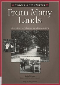
Book, Voices and stories from many lands: a century of change in Boroondara, 2001
Stories of the backgrounds of a cross-section of City of Boroondara residents focusing on how they came to live in Australia and in the City of Boroondara in particular. Many were based on oral histories. Commissioned by the City of Boroondara, the team behind "From Many Lands" also received a Local History Award, which allowed them to mount a small touring exhibition. Two Surrey Hills people contributed to the book: Margaret Grossman (nee Sarovich) and Zdzislawa (June) Wasylkowski; photo of Walter Ives also included. Sue Barnett interviewed June Wasylkowski; the interview is part of the Surrey Hills Historical Society collection. Both Margaret (Peg) and June were members of the Surrey Hills Historical Society. Martin Foot was a Council staff member at the time of publication.H 24.7 cm(ms) ruth mclean, (mrs) margaret grossman, (miss) margaret sarovich, (mrs) zdzislawa june wasylkowski, immigrants, oral history, boroondara, (mr) walter ives, sue barnett, june wasylkowski -
 City of Greater Bendigo - Civic Collection
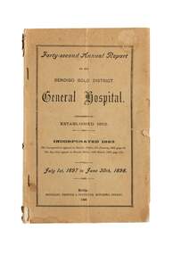
Financial record - Annual report, Bendigo Hospital, Bendigo Gold District General Hospital, 1898
The Bendigo Base Hospital was established in 1853 as the Bendigo Gold District General Hospital. This forty second Annual Report provides a detailed account of finances, building and maintenance works. The report also provided information on the number of people admitted, their occupation, residence area, operations undertaken. The largest number of patients were listed as those doing domestic duties (522), with labourers (333), miners (264) and school children (220) making up the top four from a total of 1886. James Buick was the Resident Surgeon during this year and his report states that the number of in-patients by far exceeded any previous years with the Hospital at full capacity most of the time. A typhoid and a measles epidemic added to the strain on resources. Printed annual report with brown paper cover. city of greater bendigo health services, councillor mcgowen, councillor h m marks, councillor j h abbott, james buick -
 Glen Eira Historical Society
Document - PARKSIDE STREET, 30, ELSTERNWICK
This file contains five items: 1/Four handwritten notes describing work carried out at 30 Parkside Street in perhaps March and April 1937. Includes items and labour. 2/ Four handwritten dated documents listing work carried out labour and items by Frank Bryant and G. Tarry in April and May 1937. 3/Two handwritten documents by Frank Bryant noting work carried out and payment made in April 1937. 4/Two handwritten documents noting payments made to Frank Bryant for labour and items in April and May 1937. 5/ List of Sands and McDougall Directory entries of residents at 30 Parkside Street handwritten compiled by Peta Darke dated 20/02/2015.parkside street, elsternwick, prior henry e, lee sarah j mrs., bryant frank, gardeners, labourers, tarry g, verandahs, gardens, lee v. j. miss, smith j. a., businesses -
Glen Eira Historical Society
Document - LEMPRIERE AVENUE
1/A newspaper cutting from The Argus 12/07/1927 (a print-out of same from Trove), praising the virtues of demolishing former mansion ‘Rozelle’ and erecting a ‘score’ of pretty modern villas from Balaclava Road directly into Green Meadows Gardens, a public reserve. Article describes modernity of homes in great details and the streetscape vistas (1 photo included) including road and pathways. 2/A Caulfield St Kilda Leader, dated 25/08/1993, article with Caulfield residents George and Edna McKaige wanting a planning amendment ‘with teeth’ to protect their Lempriere Ave streetscape. Andrew Ward, Heritage Architect, identified Lempriere Ave as one of Caulfield’s significant areas, because of its Interwar streetscape.east st kilda, ‘rozelle’ mansions, balaclava, land subdivision, balaclava road, georgian style, spanish mission style, orrong road, greenmeadows gardens, lempriere avenue, leadlight, mckaige george, power and telegraph lines, triple-fronted style, interwar streetscape, mckaige edna, ward andrew, caulfield council, elsternwick, welsh heather (councillor), councillors, akehurst jeff, caulfield heritage watch, spencer david, johnson john dr., ‘kilwinning’, george h., peterson william mrs., ‘melby’, ‘springfield’, rose-watt miss, ‘rozelle’, ‘cressy house’, meadow street, smith wallace m., heron herbert l., ‘goathland’, ‘melbe’, wright james, marsh malcolm reginald, house names, melby avenue, springfield avenue, goathlands street, kilwinning court, heritage studies, town planning -
 Federation University Art Collection
Ceramic - Ceramic - hand built & coloured porcelain, Lo, Li Feng, 'Natural Series (Earth, Sky, Water)', by Li-Feng Lo, 2010
My work is informed by a philosophical and spiritual engagement with Buddhist ideas, particularly in response to environmental concerns. In this work I wanted to challenge myself and explore the limits of clay material. Clay allowed me to express myself and free my mind. When I revisited Australia in 2010 form my residency, the natural environment here still was the best to me. Li-Feng LO (1967- ) Born Taiwan Ceramic artist Dr Li-Feng Lo completed a PhD at Monash University in 2008. She was a resident artist in the Federation University Arts Academy ceramics studio in 2010. Li-Feng worked with Southern Ice porcelain to create sculptural forms in response to environmental concerns. Her work is informed by a philosophical and spiritual engagement with Buddhist ideas. These works were exhibited in the exhibition 'AIRed' at the Post Office Gallery in 2011. This was a group exhibition showcasing the work of six artists who undertook residencies at the Arts Academy over a couple of years. This item is part of the Federation University Art Collection. The Art Collection features over 1000 works and was listed as a 'Ballarat Treasure' in 2007.Handbuilt (pinched), coloured porcelain form. Artist's Statement: In the beginning I try to use clay to achieve a dream-like quality by providing a feeling of flexibility like paper and fragility like glass. I was my artwork to the one with nature. Gift of the artist, 2010art, artwork, li-feng lo, ceramics, artist in residence, available, available ceramics, chinese -
 Wodonga & District Historical Society Inc
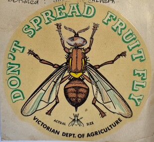
Document - Fruit Fly Border Express Pass, De Neefe Signs Pty. Ltd, c1960
The permanent fruit fly road blocks in Victoria began in 1958. The first was set up on the Lincoln Causeway between Albury and Wodonga. The aim was to protect the Victorian fruit export industry, the largest in the country. Cars would be stopped and inspected when entering Victoria. At peaks periods, such as Easter and school holidays, there were up to 10 inspectors at the 24 hour checkpoint near the former butter factory on the Lincoln Causeway. Local residents could apply for a pass such as this one which would be displayed on their window, but were still subject to random checks. Hundreds of tonnes of fruit each week was confiscated and pulverised by Department of Agriculture staff. The road block was closed in 1980, partly due to the increased traffic flows and the cost of maintaining inspection points.This image reflects government measures taken to protect the fruit industry in Victoria.A transparent sticker designed to be applied to a car window for motorists to pass through Department of Agriculture fruit fly control points. Instructions for applying the sticker to the window are written on the back of the sticker. It features a large coloured image of a fruit fly as well as a smaller life sized representation of a fruit fly.Around the edge of the circle: "DON'T SPREAD FRUIT FLY/ VICTORIAN DEPT. OF AGRICULTURE? Beside small fruit fly image: "Actual Size"fruit fly control, department of agriculture, fruit fly pass -
 Wodonga & District Historical Society Inc
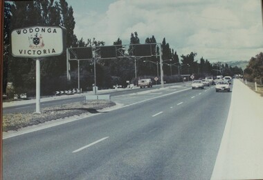
Photograph - Wodonga, Victoria sign and the Fruit Fly check point c1970s
The permanent fruit fly road blocks in Victoria began in 1958. The first was set up on the Lincoln Causeway between Albury and Wodonga. The aim was to protect the Victorian fruit export industry, the largest in the country. Cars would be stopped and inspected when entering Victoria. At peaks periods, such as Easter and school holidays, there were up to 10 inspectors at the 24 hour checkpoint near the former butter factory on the Lincoln Causeway. Local residents could apply for a pass which would be displayed on their window, but were still subject to random checks. Hundreds of tonnes of fruit each week was confiscated and pulverised by Department of Agriculture staff. The road block was closed in 1980, partly due to the increased traffic flows and the cost of maintaining inspection points.This image reflects government measures taken to protect the fruit industry in Victoria.A large image of the LIncoln Causeway at the Victorian/NSW border at Wodonga. The southbound lanes on the right hand side feature overhead signals and traffic light signs to control traffic leading into the Fruit fly inspection checkpoint ahead. The photo is in a wooden frame.On right hand side: Border sign: Wodonga/Victoria and the Victorian State Coat of Arms.fruit fly control, victoria border, lincoln causeway wodonga -
 Kiewa Valley Historical Society
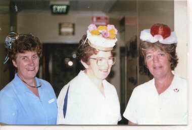
Photographs – Photographs of staff from Tawonga District General Hospital & Alpine Health – Set of 13 colour photographs
In the early stages of the Kiewa Hydro-Electric Scheme the State Electricity Commission took over the financial and construction responsibility of the Tawonga District General Hospital building at a cost of 27,000 pounds. This included the removal and re-erection of the ex-military Bonegilla ward from Wodonga while in addition they carried out all the necessary building works that allowed the hospital to operate as a functional unit. The work was completed and handed over to the Hospital Committee of Management on September 1, 1949. Local residents raised 3,400 pounds through fund raising. The balance was met by the SEC and the Hospital and Charities Commission. The initial project was to provide for a basic temporary hospital which was later to include an Operating Theatre, Offices, Store, Mortuary and a Nurse’s Home, until the establishment of a permanent medical premises. Following the opening, 455 patients were admitted to the Tawonga District General Hospital and 254 operations were performed in the first year. The hospital relocated to Mount Beauty in the former SEC administration offices located in the town centre. Official opening of the 18 bed Tawonga District General Hospital on April 29 in 1961. Kiewa Valley House nursing home was officially opened on March 6th, 1985, with a new lounge extension opening in May, 1993. Prior to this, residents had to travel to Beechworth, Wangaratta or Wodonga for care. The old weatherboard building was demolished around the late 1900’s to early 2000’s and replaced with a new modern brick building. Alpine Health CEO Mr Lyndon Seys oversaw the opening of the new Mount Beauty Hospital in November 2001 alongside Board of Management President Mr Andrew Randell, other board members and politicians.The Kiewa Hydro-Electric Scheme the State Electricity Commission played a pivotal part in the planning and initial funding of the Tawonga District General Hospital, with a view to providing medical support for its many workers on the Hydro scheme. Later, spouse and family members of workers were also able to access medical assistance. Many SEC workers and their families have received high medical care at Tawonga District General Hospital and Alpine Health and/or as residents of Kiewa Valley House over the years. A number of family members of SECV workers as well as other dedicated staff have provided high quality medical attention and support in all three facilities as nursing staff, support staff and volunteers. Many past staff members and their families still remain living in the Kiewa Valley area Set of 13 colour photographs of past nursing staff and support staff from Tawonga District General Hospital, Kiewa Valley House & Alpine Health 1. Marg Hickey, Barbara Clark & Margaret Ranton 2. Cheryl Clutterbuck & Rosemary Forrest 3. Margaret Ranton 4. Margaret Ranton holding unknown infant 5. Gwen Goss 6. Barbara Clark & Margaret Ranton 7. Margaret Ranton, Sue Zeinert & Jenny Piera 8. Margaret Ranton, Gloria Ryder & Jenny Piera 9. Sue Wesley, Ruth Barton, Margaret Ranton, Rosemary Forrest & Nola Henry 10. F Bogaski & H Sigmund 11. Maintenance Supervisor H Sigmund 12. Gardener Fred Keat & Handyman Joe Trezise (1977) 13. Nursing staff in new hospital 1-9 No markings 10 F Bogaski & H Sigmund 11. Maintenance Supervisor H Sigmund 12. Gardener Fred Keat & Handyman Joe Trezise (1977) 13. Nursing staff in new hospital tawonga district general hospital, kiewa valley house, alpine health -
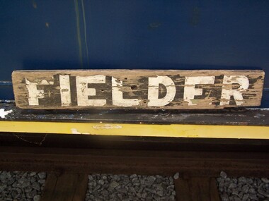 Puffing Billy Railway
Station Sign - Fielder
Station Sign - Fielder Fielder Station is situated on the Puffing Billy Railway in Australia. It opened as a Stopping Place on Monday 10 September 1928, as part of the Gembrook railway line. It was originally an unnamed platform, with time tables noting a station at 38 miles (61 km). In 1929, local Harry Watson constructed a Mallee shed and unofficially named it Ancaster after his home town in Lincolnshire, England, but this was quickly changed by some children to Laura, who was a young local girl. The Victorian Railways officially named it Fielder from Tuesday 5 February 1929, after a nearby resident. It was planned to name the station after the two local residents Cullen and Fielder and combinations of the two names were suggested, however Fielder was the name finally chosen. It remained nothing more than a Mallee shed with small office and a name board for the rest of its operating life. It was closed with the line on 30 April 1954 and the Mallee shed was sold to US Buslines for unknown use. After closure, the site fell into disrepair, and by the 1990s, little trace of Fielder remained. However, by that time, efforts were being made to extend the railway from Lakeside through to Gembrook, which would complete the entire length of the original line. In 1996, a group of volunteers led by Richard Schurmann in collaboration with the descendants of the Fielder family rebuilt the platform and waiting shed, which was officially re-opened on Saturday 19 April 1997 in preparation for the extension of the line which re-opened in 1998. On 18 November 2012 a plaque was unveiled on the station shed in tribute to the Fielder Family Trains do not normally stop at Fielder ref: https://en.wikipedia.org/wiki/Fielder_railway_station photos at http://www.vicrailstations.com/Gembrook/Fielder/Fielder.htmlHistoric - Station sign used at Fielder StationStation Sign - Fielder wooden rectangle Station name sign pained black background with white lettersFielderpuffing billy, station sign, fielder station -
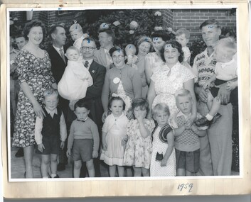 Melbourne Legacy
Photograph, From Stanhope News, 1959
Two photos from a book compiled about the Legacy children's residence called Stanhope. One photo shows a reunion in 1959 featuring several past residents, their husbands and children. Faces have small numbers indicating their names which were recorded on the back: 1 Margaret Guy, 2 Greg Guy, 3 and 4 are their children. 5 Bab Thompson 6 his wife, 7 their child. 8 Alice Cameron and 9 her husband (Black) and their four children. 10 is Lois Clark (nee Fitzsimmons) and one child. 11 Doreen Ashworth and 12 is her husband (Closter) and their three children. The other photo shows two children of past residents. Names written on the page it was stuck on were 'Boy Guy' and 'Baby John Frost'. Stanhope was supervised by Matron Dorothy (Dorrie) Vines from the time it opened in 1946 until she retired in December 1966. It is likely she compiled this notebook. Individual pages of photos or newspaper clippings have been added separately. Items 01817 to 01836. Blamey House (purchased 1947) , Stanhope (purchased 1945) and Harelands (purchased 1950) were residences run by Melbourne Legacy to take care of children whose fathers were servicemen, and who may have been left orphans, or whose mother may have been unable to care for them herself, or they needed to stay in Melbourne for further education. Generally, Harelands accommodated boys and girls under the age of 14, Blamey House looked after boys over 14, and Stanhope looked after girls over 14. The children were cared for until they were old enough to become independent. A record of a reunion at Stanhope. A great example of the impact the residence and care had on the lives of the junior legatees that they kept in touch with each other and the home.Black and white photo of a group of people and a photo of a boy and baby at a Stanhope reunion in 1959.residences, reunion, stanhope -
The Beechworth Burke Museum
Audio - Oral History, Jennifer Williams, Mr Bill Gerrard, 10 August 2000
Bill Gerrard was born in Albury in 1934 and moved to Beechworth in 1960 when his wife was employed as a nurse at Mayday Hills Hospital, later becoming nurse-in-charge. Gerrard first worked for the local railway and then as a taxi driver in Beechworth, and was involved in volunteer fund-raising activities such as raffles for charitable causes. This oral history recording was part of a project conducted by Jennifer Williams in the year 2000 to capture the everyday life and struggles in Beechworth during the twentieth century. This project involved recording seventy oral histories on cassette tapes of local Beechworth residents which were then published in a book titled: Listen to what they say: voices of twentieth century Beechworth. These cassette tapes were digitised in July 2021 with funds made available by the Friends of the Burke.Mr Bill Gerrard's account of his life in Beechworth and the local area during the mid-to-late 20th century is historically and socially significant to the cultural heritage of the region. He recounts aspects of community life and working conditions in Beechworth, particularly during the 1960s and 1970s, as well as conditions for staff and patients at Mayday Hills Hospital where his wife worked during that period. His story also provides insights into economic hardhsip and the role of voluntary fundraising in the Beechworth community. This oral history recording was part of a project conducted by Jennifer Williams in the year 2000 to capture the everyday life and struggles in Beechworth during the twentieth century. This project involved recording seventy oral histories on cassette tapes of local Beechworth residents which were then published in a book titled: Listen to what they say: voices of twentieth century Beechworth. These cassette tapes were digitised in July 2021 with funds made available by the Friends of the Burke.This is a digital copy of a recording that was originally captured on a cassette tape. The cassette tape is black with a horizontal white strip and is currently stored in a clear flat plastic rectangular container. It holds up 40 minutes of recordings on each side.Mr Bill Gerrard /listen to what they say, beechworth, oral history, burke museum, bill gerrard, mayday hills hospital, taxi driver, beechworth railway, religion, beechworth 1960s, beechworth 1970s, social welfare, community cohesion, twentieth-century working conditions, twentieth-century regional victoria, hibernian hotel, fund-raising -
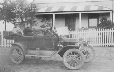 Federation University Historical Collection
Photograph, Harold Hauson, Members of the Wright family outside "Laura Villa" Smeaton, (estimated); early 1930's
In 1860 Smeaton residents appealed for funds to establish a school. Patrick Curtain, and his co-workers raised more than £150 plus a land grant (Allot A, Sect 2, Township of Smeaton). Head Teacher John Forbes, with assistant Zillah North, opened a timber school building which measured 36ftx18ft (11.0x5.5m) on 1 September 1861 with 44 children. Rising enrolment to 65 in 1868 made building alterations necessary. During 1870-1 a residence of four rooms was supplied and in October 1882 a 20ftx18ft (6.1x5.5m) classroom. In 1907 a new brick building accommodated 122 children. Among notable ex-pupils are Major-General Bridgeford, Frank Wright ( Musical Director of the London County Council), Alex Wright, (AKA singer Andre Navarre), and Les Brooks. (Visions and Realisations) Sepia photograph showing 4 people sitting in a 1914 Ford Model T Touring Car outside The Wright Familys' "Laura Villa" property at Smeaton. Left hand back seat - Mrs W. Wright, Mrs Kelso Front seat: F.L.Redman (driving), W. WrightTaken at "Laura Villa" Smeaton by Harold Hausenfrank wright, laura villa, smeaton, car, 1914 ford model t touring car -
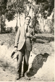 Federation University Historical Collection
Photograph - Photo, Bill Fargher, Frank Wright at Daylesford, 1/1/1924 (exact); 1924
In 1860 Smeaton residents appealed for funds to establish a school. Patrick Curtain, and his co-workers raised more than £150 plus a land grant (Allot A, Sect 2, Township of Smeaton). Head Teacher John Forbes, with assistant Zillah North, opened a timber school building which measured 36ftx18ft (11.0x5.5m) on 1 September 1861 with 44 children. Rising enrolment to 65 in 1868 made building alterations necessary. During 1870-1 a residence of four rooms was supplied and in October 1882 a 20ftx18ft (6.1x5.5m) classroom. In 1907 a new brick building accommodated 122 children. Among notable ex-pupils are Major-General Bridgeford, Frank Wright ( Musical Director of the London County Council), Alex Wright, (AKA singer Andre Navarre), and Les Brooks. (Visions and Realisations) Frank Wright, aged 22, in a bush location at Daylesford - possibly at a mineral water spring.frank wright, daylesford -
 Federation University Historical Collection
Photograph - Colour, Barcaldine Tree of Knowledge, 1998, 07/1998
Its twisted old trunk is gnarled, its disembowelled carcass plump with cement and now, like many outback legends, its cadaverously pale and very dead. It has stood, an unmolested leafy sentinel, over Barcaldine’s Railway Station depot since the 1880s. It was a living Australian Labor Party memorial and heritage-listed. The double centurion, Oak Street’s most senior resident, was respectfully nursed into its dotage by Barcaldine’s faithful. Countless thousands of travellers photographed it, patted it and peered up at its bushy green tops with dutiful reverence. ... And then, by an act of craven foul play, it was murdered. Allegedly. Cold, hard forensic science pronounced death by poisoning. Sometime around May Day 2007 they reckon. (Australian Travellor, November 25, 2007.)Photograph of Philip and Elizabeth under the Barcaldine Tree. It was in the shade of this tree the Australian workers rallied and the Australian Labor Party was formed after the ramifications of the great shearers strike in 1891.barcaldine tree, australian labor party, chatham-holmes family collection -
 Kiewa Valley Historical Society
Photograph from Lake Guy, Bogong Village, Scene from shores of Lake Guy to Mountain range, 1930s to 1950s
In 1940 Field Headquarters for the Kiewa Scheme were established at Bogong with office, workshop facilities and accommodation for workmen, staff and some families constructed. (There had been a 'tent camp' on this site in 1939 but was destroyed by bushfires) Construction of accommodation continued until 1947. A total of 40 houses plus a hostel for single staff, post office, police station, medical centre and primary school all with water and sewerage and electricity supply. The staff hostel was known as Kiewa House and is now occupied by the Education Department. Lake Guy was named after Mr. L.T. Guy who was the Resident Engineer in charge of construction work and associated activities on the Kiewa area. He held this position from 1939 to November 1946 when he was transferred to Head Office.The Bogong Township was developed firstly as an accommodation centre (base camp) for construction workers employed under the Kiewa Hydroelectric Scheme. Due to the influx of European workers into the Township the beautification of the immediate surrounds(gardens etc.) had a distinct European flavour. This environment has been very beneficial for tourism in later years. Strict environmental control has not allowed for any extensive redevelopment in tourist accommodation and basically restricted it to the accommodation initially built for the construction workers. Activities such a bike riding, snow skiing, restricted horse riding and bush walking on the Alpine plains and mountains are now a viable part of the Kiewa Valley Tourist Industry. The lake is one of the many water storage storage reservoirs used to supply the power stations their main power to run the huge turbines generating the final product, electricityThis black and white photograph shot from the shores of Lake Guy toward the mountain range of the Victorian Alps details the early construction of the construction worker's accommodation of the Bogong Village. The paper is of 200gms and is not photographic paper and can be assumed to be a reproduction of an original photobogong village circa 1930 to 1950, kiewa hydro-electricity scheme, victorian alpine region mid 1900s -
 Kiewa Valley Historical Society
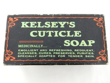
Box Cuticle Soap, mid to late 1900's
The mid 1900's provided the start of "the body beautiful" revolution. The cosmetic industry, with the help of quasi scientific selling advertising slant targeted those "customers" that needed the "extra care" factor that only their product could offer. At this period in time their advertising power was based on in store, radio and newspaper media channels with saturation levels relatively low. In the later years of the 1900's saturation levels and a wider range of products and increased competition further increased the product saturation levels available to the buying residents. With the introduction of television the advertisements become more elaborate and "catchy" words, phrases and comedy type situations helped boost the advertising "pitch" and subliminal undertones to effective levels required for a highly competitive health related market place. 'sellingThis subliminally,"medically" endorsed product was one of many during the great "spin" revolution of product marketing and selling. This item is significant in that it demonstrates that greater infusion of product awareness throughout rural areas was highly successful through a greater variety of advertising media. It also demonstrates that in a highly competitive marketplace there are no physical boundaries that impinge upon the distribution of products and services. The rural sector is a highly lucrative region for any product that helps protect the body from all the "nasty's" that become more noticeable in a rural environment. This rectangular box which had contained cuticle soap is constructed from cardboard and reinforced by a black nylon impregnated sheeting. This impregnation was required to keep the box from soaking up any water from the user's hands. The top section of the box(lid) has and in large print "KELSEY'S" top line followed by "CUTICLE" off to the right and underneath and to the right "SOAP". Below this and in smaller print is "MEDICINALLY..." below this and in smaller print "EMOLLIENT AND REFRESHING, REDOLENT, CLEANSES, CURES, PRESERVES, PURIFIES." and last line underneath "SPECIALLY ADAPTED FOR TENDER SKIN" On each of the sides of the top lid are, side 1 "INVALUABLE FOR THE NURSERY." underneath in smaller print "JOHN M. KELSEY CO." to the left of this and on a green backed highlighter "No. 1744 - Guaranteed under Pure Food Act, 1908, N.S.W. by John M. Kelsey Co. - No. 1744. Melbourne, Victoria." On the right side and in large print "KELSEY'S CUTICLE SOAP" on the next side and also a similar sign on the opposite side "SPECIALLY ADAPTED FOR TENDER SKIN." below this "JOHN M. KELSEY CO." "Registered" and on the other long side in large print "SPECIALLY ADAPTED FOR TENDER SKIN" underneath in smaller print JOHN M. KELSEY CO. Registered"specialised soap, toilet requisites, nursery health., bathroom, domestic -
 Kiewa Valley Historical Society
Photograph of Lake Guy and Bogong Village, Lake Guy and Bogong Village, Approx. 1945
In 1940 Field Headquarters for the Kiewa Scheme were established at Bogong with office, workshop facilities and accommodation for workmen, staff and some families constructed. (There had been a 'tent camp' on this site in 1939 but was destroyed by bushfires) Construction of accommodation continued until 1947. A total of 40 houses plus a hostel for single staff, post office, police station, medical centre and primary school all with water and sewerage and electricity supply. The staff hostel was known as Kiewa House and is now occupied by the Education Department. Lake Guy was named after Mr. L.T. Guy who was the Resident Engineer in charge of construction work and associated activities on the Kiewa area. He held this position from 1939 to November 1946 when he was transferred to Head Office.This photograph is an excellent historical record of Bogong Village in about 1945. It shows the layout of the town in the fairly steep terrain, the workmen's camp between the houses and the lake foreshore, the Commissioner's Lodge on the hill behind the Village, the walkway through the dam wall can be seen to the left of the spillway, the dam is on spill and note damage to the large trees is still evident from the 1939 bush fires. The Commissioner's Lodge was lost in the 2003 fires and the camp buildings were in service until 1962, when they were removed and the site converted into a public picnic area with lawns and gardens.A Black and white photograph"Lake Guy and Bogong" hand written on back of photograph.kiewa, accommodation, lake, dam, bogong -
 Kiewa Valley Historical Society
Photo - Bogong Township, March 1944
In 1940 Field Headquarters for the Kiewa Scheme were established at Bogong with office, workshop facilities and accommodation for workmen, staff and some families constructed. (There had been a 'tent camp' on this site in 1939 but was destroyed by bushfires) Construction of accommodation continued until 1947. A total of 40 houses plus a hostel for single staff, post office, police station, medical centre and primary school all with water and sewerage and electricity supply. The staff hostel was known as Kiewa House and is now occupied by the Education Department. Lake Guy was named after Mr. L.T. Guy who was the Resident Engineer in charge of construction work and associated activities on the Kiewa area. He held this position from 1939 to November 1946 when he was transferred to Head Office. The Bogong Township was developed firstly as an accommodation centre (base camp) for construction workers employed under the Kiewa Hydroelectric Scheme. Due to the influx of European workers into the Township the beautification of the immediate surrounds (gardens etc.) had a distinct European flavour. This environment has been very beneficial for tourism in later years. At the completion of the scheme, in the 1960's, the village was opened to public/tourism use. Strict environmental control has not allowed for any extensive redevelopment in tourist accommodation and basically restricted it to the accommodation initially built for the construction workers. Activities such a bike riding, snow skiing, restricted horse riding and bush walking on the Alpine plains and mountains are now a viable part of the Kiewa Valley Tourist Industry. The lake is one of the many water storage reservoirs used to supply the power stations their main power to run the huge turbines generating the final product, electricityBlack and white photograph of Bogong Township taken March 1944Handwritten on the back of photo - Township March '44bogong village, secv -
 Kiewa Valley Historical Society
Photograph - Bogong Village (7 copies), Approx 1940
In 1940 Field Headquarters for the Kiewa Scheme were established at Bogong with office, workshop facilities and accommodation for workmen, staff and some families constructed. (There had been a 'tent camp' on this site in 1939 but was destroyed by bushfires) Construction of accommodation continued until 1947. A total of 40 houses plus a hostel for single staff, post office, police station, medical centre and primary school all with water and sewerage and electricity supply. The staff hostel was known as Kiewa House and is now occupied by the Education Department. Lake Guy was named after Mr. L.T. Guy who was the Resident Engineer in charge of construction work and associated activities on the Kiewa area. He held this position from 1939 to November 1946 when he was transferred to Head Office. The Bogong Township was developed firstly as an accommodation centre (base camp) for construction workers employed under the Kiewa Hydroelectric Scheme. Due to the influx of European workers into the Township the beautification of the immediate surrounds (gardens etc.) had a distinct European flavour. This environment has been very beneficial for tourism in later years. At the completion of the scheme, in the 1960's, the village was opened to public/tourism use. Strict environmental control has not allowed for any extensive redevelopment in tourist accommodation and basically restricted it to the accommodation initially built for the construction workers. Activities such a bike riding, snow skiing, restricted horse riding and bush walking on the Alpine plains and mountains are now a viable part of the Kiewa Valley Tourist Industry. The lake is one of the many water storage reservoirs used to supply the power stations their main power to run the huge turbines generating the final product, electricity. Evidence can be seen of the 1939 bushfires.Set of 7 identical black and white photographs of Bogong Village after 1939 bush firesHandwritten on the back of one photo - Bogong Village approx. 1940, after 1939 bush fires. Staff residences to left. Kiewa House, General offices and test lab to the right. Hand drawn map on the back of one photo.bogong village, secv -
 Kiewa Valley Historical Society
Photo - Bogong Village Township, October 8, 1946
In 1940 Field Headquarters for the Kiewa Scheme were established at Bogong with office, workshop facilities and accommodation for workmen, staff and some families constructed. (There had been a 'tent camp' on this site in 1939 but was destroyed by bushfires) Construction of accommodation continued until 1947. A total of 40 houses plus a hostel for single staff, post office, police station, medical centre and primary school all with water and sewerage and electricity supply. The staff hostel was known as Kiewa House and is now occupied by the Education Department. Lake Guy was named after Mr. L.T. Guy who was the Resident Engineer in charge of construction work and associated activities on the Kiewa area. He held this position from 1939 to November 1946 when he was transferred to Head Office. The Bogong Township was developed firstly as an accommodation centre (base camp) for construction workers employed under the Kiewa Hydroelectric Scheme. Due to the influx of European workers into the Township the beautification of the immediate surrounds (gardens etc.) had a distinct European flavour. This environment has been very beneficial for tourism in later years. At the completion of the scheme, in the 1960's, the village was opened to public/tourism use. Strict environmental control has not allowed for any extensive redevelopment in tourist accommodation and basically restricted it to the accommodation initially built for the construction workers. Activities such a bike riding, snow skiing, restricted horse riding and bush walking on the Alpine plains and mountains are now a viable part of the Kiewa Valley Tourist Industry. The lake is one of the many water storage reservoirs used to supply the power stations their main power to run the huge turbines generating the final product, electricityBlack and white photograph of Bogong Village which appeared in the Herald Sun newspaper on October 8, 1946. Page 13Handwritten on the back - Town of Bogong on a rugged mountain slope above Lake Guy. State Electricity Committee workers on the Kiewa Hydro Electric scheme live here in all electric homes. Stamped on the back - Copyright Not for reproduction Herald Sun Feature Service Melbourne Australiabogong village; lake guy; kiewa hydro electric scheme -
 Kiewa Valley Historical Society
Postcard - Lake Guy and Bogong Village
In 1940 Field Headquarters for the Kiewa Scheme were established at Bogong with office, workshop facilities and accommodation for workmen, staff and some families constructed. (There had been a 'tent camp' on this site in 1939 but was destroyed by bushfires) Construction of accommodation continued until 1947. A total of 40 houses plus a hostel for single staff, post office, police station, medical centre and primary school all with water and sewerage and electricity supply. The staff hostel was known as Kiewa House and is now occupied by the Education Department. Lake Guy was named after Mr. L.T. Guy who was the Resident Engineer in charge of construction work and associated activities on the Kiewa area. He held this position from 1939 to November 1946 when he was transferred to Head Office. The Bogong Township was developed firstly as an accommodation centre (base camp) for construction workers employed under the Kiewa Hydroelectric Scheme. Due to the influx of European workers into the Township the beautification of the immediate surrounds (gardens etc.) had a distinct European flavour. This environment has been very beneficial for tourism in later years. At the completion of the scheme, in the 1960's, the village was opened to public/tourism use. Strict environmental control has not allowed for any extensive redevelopment in tourist accommodation and basically restricted it to the accommodation initially built for the construction workers. Activities such a bike riding, snow skiing, restricted horse riding and bush walking on the Alpine plains and mountains are now a viable part of the Kiewa Valley Tourist Industry. The lake is one of the many water storage reservoirs used to supply the power stations their main power to run the huge turbines generating the final product, electricityBlack and white photographic postcard of Lake Guy and Bogong Village. Kiewa Hydro electric Project (showing Junction Dam in front)Handwritten on the back of postcard ' Like most of our camps, this looks like something from the Canadian Rockies' Stamped on the back - Valentine's Post Card A genuine photographlake guy, bogong village, secv -
 Kiewa Valley Historical Society
Photo - Bogong Township, September 1953
In 1940 Field Headquarters for the Kiewa Scheme were established at Bogong with office, workshop facilities and accommodation for workmen, staff and some families constructed. (There had been a 'tent camp' on this site in 1939 but was destroyed by bushfires) Construction of accommodation continued until 1947. A total of 40 houses plus a hostel for single staff, post office, police station, medical centre and primary school all with water and sewerage and electricity supply. The staff hostel was known as Kiewa House and is now occupied by the Education Department. Lake Guy was named after Mr. L.T. Guy who was the Resident Engineer in charge of construction work and associated activities on the Kiewa area. He held this position from 1939 to November 1946 when he was transferred to Head Office. The Bogong Township was developed firstly as an accommodation centre (base camp) for construction workers employed under the Kiewa Hydroelectric Scheme. Due to the influx of European workers into the Township the beautification of the immediate surrounds (gardens etc.) had a distinct European flavour. This environment has been very beneficial for tourism in later years. At the completion of the scheme, in the 1960's, the village was opened to public/tourism use. Strict environmental control has not allowed for any extensive redevelopment in tourist accommodation and basically restricted it to the accommodation initially built for the construction workers. Activities such a bike riding, snow skiing, restricted horse riding and bush walking on the Alpine plains and mountains are now a viable part of the Kiewa Valley Tourist Industry. The lake is one of the many water storage reservoirs used to supply the power stations their main power to run the huge turbines generating the final product, electricityBlack and white photograph of Bogong Township taken from Little Arthur fire track. September 1953Faded handwritten inscription on back - Bogong Township taken from Little Arthur fire track. Sept 1953bogong village, secv -
 Kiewa Valley Historical Society
Photo - First Bogong Camp, September 1950
In 1940 Field Headquarters for the Kiewa Scheme were established at Bogong with office, workshop facilities and accommodation for workmen, staff and some families constructed. (There had been a 'tent camp' on this site in 1939 but was destroyed by bushfires) Construction of accommodation continued until 1947. A total of 40 houses plus a hostel for single staff, post office, police station, medical centre and primary school all with water and sewerage and electricity supply. The staff hostel was known as Kiewa House and is now occupied by the Education Department. Lake Guy was named after Mr. L.T. Guy who was the Resident Engineer in charge of construction work and associated activities on the Kiewa area. He held this position from 1939 to November 1946 when he was transferred to Head Office. The Bogong Township was developed firstly as an accommodation centre (base camp) for construction workers employed under the Kiewa Hydroelectric Scheme. Due to the influx of European workers into the Township the beautification of the immediate surrounds (gardens etc.) had a distinct European flavour. This environment has been very beneficial for tourism in later years. At the completion of the scheme, in the 1960's, the village was opened to public/tourism use. Strict environmental control has not allowed for any extensive redevelopment in tourist accommodation and basically restricted it to the accommodation initially built for the construction workers. Activities such a bike riding, snow skiing, restricted horse riding and bush walking on the Alpine plains and mountains are now a viable part of the Kiewa Valley Tourist Industry. The lake is one of the many water storage reservoirs used to supply the power stations their main power to run the huge turbines generating the final product, electricityBlack and white photo of Bogong Village. September 1950Handwritten on the back - 1st Bogong Camp. SEC Kiewa Scheme Sept 1950bogong camp, bogong village, secv -
 Kiewa Valley Historical Society
Photo - Bogong Village Township
In 1940 Field Headquarters for the Kiewa Scheme were established at Bogong with office, workshop facilities and accommodation for workmen, staff and some families constructed. (There had been a 'tent camp' on this site in 1939 but was destroyed by bushfires) Construction of accommodation continued until 1947. A total of 40 houses plus a hostel for single staff, post office, police station, medical centre and primary school all with water and sewerage and electricity supply. The staff hostel was known as Kiewa House and is now occupied by the Education Department. Lake Guy was named after Mr. L.T. Guy who was the Resident Engineer in charge of construction work and associated activities on the Kiewa area. He held this position from 1939 to November 1946 when he was transferred to Head Office. The Bogong Township was developed firstly as an accommodation centre (base camp) for construction workers employed under the Kiewa Hydroelectric Scheme. Due to the influx of European workers into the Township the beautification of the immediate surrounds (gardens etc.) had a distinct European flavour. This environment has been very beneficial for tourism in later years. At the completion of the scheme, in the 1960's, the village was opened to public/tourism use. Strict environmental control has not allowed for any extensive redevelopment in tourist accommodation and basically restricted it to the accommodation initially built for the construction workers. Activities such a bike riding, snow skiing, restricted horse riding and bush walking on the Alpine plains and mountains are now a viable part of the Kiewa Valley Tourist Industry. The lake is one of the many water storage reservoirs used to supply the power stations their main power to run the huge turbines generating the final product, electricityBlack and white photograph of Bogong Village from across Lake Guy. Photo mounted on buff cardbogong village, secv -
 Kiewa Valley Historical Society
Photograph – Set of 3 black and white photographs of Bogong Village circa late 1930's - 1940's during early construction of Lake Guy ( in the foreground), Late 1930's - 1940's
In 1940 Field Headquarters for the Kiewa Scheme were established at Bogong with office, workshop facilities and accommodation for workmen, staff and some families constructed. (There had been a 'tent camp' on this site in 1939 but was destroyed by bush fires) Construction of accommodation continued until 1947. A total of 40 houses plus a hostel for single staff, post office, police station, medical centre and primary school all with water and sewerage and electricity supply. The staff hostel was known as Kiewa House and is now occupied by the Education Department. Lake Guy was named after Mr. L.T. Guy who was the Resident Engineer in charge of construction work and associated activities on the Kiewa area. He held this position from 1939 to November 1946 when he was transferred to Head Office. The Bogong Township was developed firstly as an accommodation centre (base camp) for construction workers employed under the Kiewa Hydroelectric Scheme. Due to the influx of European workers into the Township the beautification of the immediate surrounds (gardens etc.) had a distinct European flavour. This environment has been very beneficial for tourism in later years. At the completion of the scheme, in the 1960's, the village was opened to public/tourism use. Strict environmental control has not allowed for any extensive redevelopment in tourist accommodation and basically restricted it to the accommodation initially built for the construction workers. Activities such a bike riding, snow skiing, restricted horse riding and bush walking on the Alpine plains and mountains are now a viable part of the Kiewa Valley Tourist Industry. The lake is one of the many water storage reservoirs used to supply the power stations their main power to run the huge turbines generating the final product, electricity3 black and white photographs of the Bogong camp area showing the clearing of trees for the construction of the Junction Dam and Lake Guy. Some administration buildings have been constructed, but part of the tent camp can be seen to the right of the photograph in front of the buildings. bogong village; junction dam; lake guy; kiewa hydro electric scheme; secv -
 The Beechworth Burke Museum
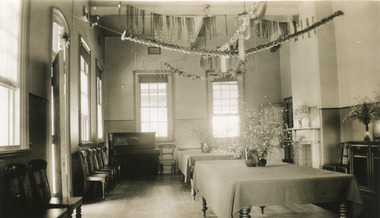
Photograph, L. Maher, 1936
Mayday Hills Mental Hospital was originally constructed in 1864 under the name of the Beechworth Lunatic Asylum. It was built for locals in need of help who were kept in the local gaol. In its first decade, the residents of the hospital were used as menial labourers but over time, as mental healthcare progressed, were cared for in more nuanced ways. This site became a training hospital for nurses in the 1960's. Eventually, mental health patients were moved to other care facilities and Mayday Hills was operating as a geriatric care facility. It was closed in 1995, after which the buildings and their grounds were purchased to La Trobe University to be used as a campus. The university sold the site in 2011 to private ownership. The image depicts an interior room which is presumed to be a dining or common room. This space has been decorated for Christmas.Mayday Hills Mental Hospital is a historically significant site for many factors. It is representative of healthcare practice in nineteenth century Victoria. It contains rare examples of construction and architecture. It is also significant for aesthetic and technical reasons. Black and white rectangular photograph printed on photographic paperObverse: PRINTED BY/ L.MAHER/ BEECHWORTH/ 1997.2702mayday, mayday hills hospital, mayday hills, mayday hills mental asylum, beechworth lunatic asylum, lunatic asylum, beechworth, gaol, beechworth hospital for the insane, beechworth mental hospital, mental hospital, hospital, nurse, nurses quarters, la trobe university, training facility, christmas, christmas party -
 The Beechworth Burke Museum
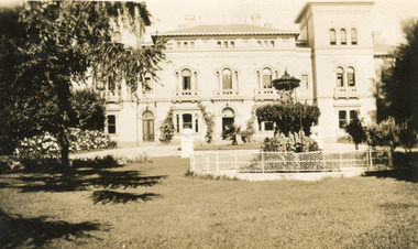
Photograph, 1930
Mayday Hills Mental Hospital was originally constructed in 1864 under the name of the Beechworth Lunatic Asylum. It was built for locals in need of help who were kept in the local gaol. In its first decade, the residents of the hospital were used as menial labourers but over time, as mental healthcare progressed, were cared for in more nuanced ways. This site became a training hospital for nurses in the 1960's. Eventually, mental health patients were moved to other care facilities and Mayday Hills was operating as a geriatric care facility. It was closed in 1995, after which the buildings and their grounds were purchased to La Trobe University to be used as a campus. The university sold the site in 2011 to private ownership. This image depicts the front facade of the building and a portion of the gardens, including a fountain. Mayday Hills Mental Hospital is a historically significant site for many factors. It is representative of healthcare practice in nineteenth century Victoria. It contains rare examples of construction and architecture. It is also significant for aesthetic and technical reasons.Black and white photograph printed on matte photographic paperReverse: Mental Hospital/ Beechworth Lunatic Asylum/ Xmas 1930/ 8190 VELOX (Watermark)mayday, mayday hills hospital, mayday hills, mayday hills mental asylum, beechworth, beechworth asylum, beechworth lunatic asylum, beechworth hospital for the insane, garden, gardens & parks, architecture, historic victorian architecture, healthcare, health, fountain, la trobe university