Showing 32107 items matching "buildings"
-
 Linton and District Historical Society Inc
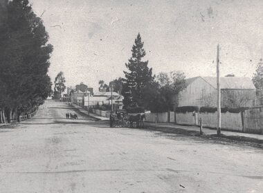
Photograph, View along Sussex Street, Linton, circa 1920
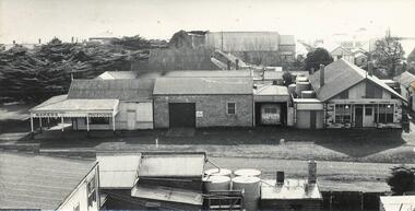
Dr Donaldson (Snr) owned the block of land on the corner of Sussex and Grant Streets, Linton. He had a ten-room house set on the back of the block (where the block backs on to Surrey Street), with a large barn fronting Sussex Street. Other identifiable buildings in the photograph are Ball Brothers blacksmith's shop, the Royal Standard Hotel on the corner of Sussex and Clyde Streets, the Shire Hall, Criterion House and Joseph Shepherd's store. The roof of Oscar Ball's house can be seen.Black and white copy of original photograph which shows houses and other buildings along Sussex Street. The view is to the south (up the hill) from the Ballarat entrance to Linton. A large barn, enclosed by a picket fence, is in the foreground. A cart drawn by two horses, with a man standing next to it, is in the street near the barn. Further along the street, a group of people appear to be wheeling a barrow or cart. Houses and other buildings can be seen along the street.sussex street linton, dr donaldson's barn, ball bros. blacksmith, royal standard hotel, shire of grenville offices linton, criterion house, joseph shepherd's store -
 Eltham District Historical Society Inc
Photograph, Harry Gilham, Renovations to Eltham State School No. 209, Dalton Street, Eltham, 1994
... buildings ...What had been the entrance to the Principal's office since when the extensions along the north wall of the 1875 building were in place (removed 1994). The thickness of the lower wall at tis section was 70cm (2' 4"). This was the 'North' door over which years of correspondence showed the need to put a porchway over it to prevent cold winds blowing over the gallery section of infants (Grades 1 / 2).Handwritten (HG's) information and details in blue ink on reverse sidedalton street, eltham primary school, renovations, building construction, buildings, eltham state school no. 209 -
 Federation University Historical Collection
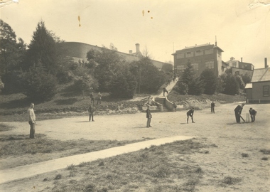
Photograph - Photograph - Black and White, Ballarat Junior Technical School Students Playing Cricket on the Battery Paddock at the Ballarat School of Mines, c1935, 1934
The Battery Paddock ran along Albert Street near the intersection of Grant Street, and was alongside the Ballarat School of Mines battery, or model mine. The Ballarat Junior Technical School was a division of the Ballarat School of Mines. It was established in 1913 at Dana Street Primary School with Albert Steane as Principal. In 1926 a custom built school in the grounds of the Ballarat School of Mines was opened. Today that building houses Prospects Training Restaurant. A number of students of the Ballarat Junior Technical School play cricket on the Battery Paddock of the Ballarat School of Mines. In the background the walls of the gaols are evident, as is the Ballarat Junior Technical School building which was built in 1926.battery paddock, ballarat school of mines, ballarat school of mines battery, ballarat school of mines model mine, ballarat junior technical school, cricket, sport, ballarat gaol, grant street, albert street -
 Phillip Island and District Historical Society Inc.
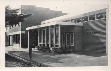
Photograph, 1959
One of 23 photographs from the Jessie Smith Collection. Donated by Stan McFeeBlack & White photograph of the Cowes Post Ofice Building with two storey brick shop building on the left overshadowed by the branch of a Pine tree.On Back: "New P.O. Cowes"phillip island, cowes, cowes post office, jessie smith collection, stan mcfee -
 Phillip Island and District Historical Society Inc.
Photograph, 1960
Donated by Jack JennerBlack & White photograph of shop buildings with Baker's shop on corner of Chapel Street & thompson Avenue. Pine trees and buildings beside and in the background.On back: "About 1960"phillip island bakery, cowes shop buildings, phillip island, jack jenner -
 Glenelg Shire Council Cultural Collection
Photograph - Photograph - construction works, Portland, n.d
Black and white photo. Building under construction on cliff top; 3 workmen, sea in background. Possibly the rifle club building in Portland.Back: Purple stamp: 'T.A. Newton'construction, town development -
 Federation University Historical Collection
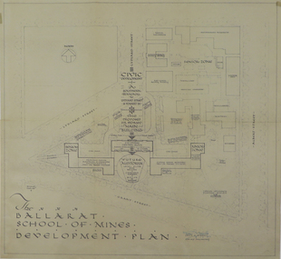
Plan, Ballarat School of Mines Development Plan, 1947, 09/12/1947
The Ballarat School of Mines was future planning before the proposed division of the tertiary division (Mt Helen Campus).Plan of the Ballarat School of Mines Lydiard Street Campus showing existing buildings, proposed demolition of all gaol buildings and court house. ballarat school of mines, development plan, former ballarat gaol, former ballarat court house, lydiard street, master plan, campus plan, ballarat school of mines campus -
 Bendigo Historical Society Inc.
Document - THE LAW COURTS, PALL MALL, BENDIGO
Typed notes on the building of the Law Courts. Mentioned is the cost, laying of the foundation stone, style of buiding, description of the layout of the building, and builders and architects.document, names of bendigo pioneers, bendigo law courts, the law courts, j w taverner, public offices, r c brown, lord hopetoun, m'culloch & m'alpine, j bennett & sons, j r fisher, post office, scurry & wardrop, annals of bendigo, royal historical society of victoria bendigo branch -
 St Kilda Historical Society
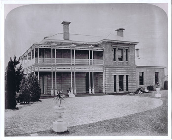
Photograph - Photograph of building, Donald McDonald, Evera, 01/01/1872
Residence of Frank G Smith, Banker in 1860s and 1870s. Part of collection of photos of St kilda houses to Vienna exhibition 1873black and white photograph of original double storey large family home Italianate style gravel forecourt, people on verandah building building -
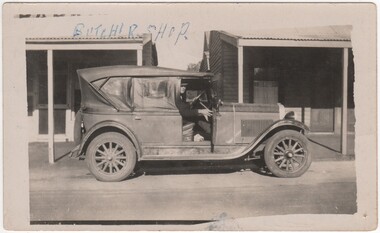 Rutherglen Historical Society
Image, c1925
Part of a collection relating to the Parkin family.Black and white photograph of a man behind the wheel of a car, parked in front of two buildings. On the left is the butcher shop, on the right a weatherboard building.Written on the photo at the top left: "Butcher Shop" On back of photo: "53 years" | "Main St Rutherglen 1925, the butcher shop & house next door. Before the Bakers shop was built." | "Sid Parkin in Chevoilt car, in family til 1978" | "Sid Parkin 1978"parkin family, butcher shop, main street, motor car -
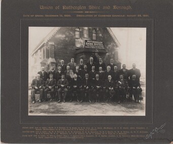 Rutherglen Historical Society
Image, Alf L. Bowden, The Studio, Union of Rutherglen Shire and Borough, 1920 (Exact)
Copy of a photograph of Wesleyan Church used as temporary Shire Office during building of new office. Group portrait of Councillors in front of building."Union of Rutherglen Shire and Borough / Date of Union: December 15, 1920. Dissolution of Combined Councils: August 25, 1921. Rutherglen Shire Office. The Secretary Attends Monday & Friday 10am till 4pm" Front row (left to right) Ex. Cr. S.P. Gollings, Cr. R. Ready, Cr. E.E. Cock, Cr. J. Burch (Ex Mayor), Cr. C.H. Morris (Shire President), J. Hiskins (Ex President), Cr. R.J. Burrowes, Cr. D.B. Smith, Cr. P. Gullifer / Centre Row (left to right) Cr. H.G. Richards, Cr. W.H. Chambers, Cr. R.H. Berryman, Cr. R.J. Harvie, Cr. W.R. McRae, Cr. W.V. McDonald, Cr. C.L. Dobbin, Cr. R.A. McLaurin, Cr. P.M. Seymour, Cr. M.T. Graham, Cr. F. Fuge, Cr J. Milthorpe / Back Row (left to right) T. Trenen (Editor "Sun"), P. Lingford (Shire Engineer), W.C. Bayliss (Banker), A.H. Thompson (Shire Secretary, A.C. Carter (Inspector), N.F. Turnbull (Assistant Secretary)" -
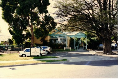 Whitehorse Historical Society Inc.
Photograph, Blackburn Children's Services Centre
Coloured photograph of a brick building with a blue canopy, cars parked in front and a council sign. The building is located at 15 Central Road Blackburn.blackburn childrens services centre, childrens services -
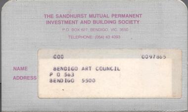 Bendigo Historical Society Inc.
Financial record - MERLE HALL COLLECTION: Arts Bendigo savings passbook
Savings Passbook (The Sandhurst Mutual Permanent Investment and Building Society) with entries from 1979 to 1983 re the 'Arts Centre Building Fund'.bendigo arts council, arts centre building fund -
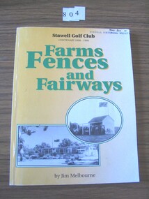 Stawell Historical Society Inc
Book, H J Melbourne, Farms, Fences and Fairways – Stawell Golf Club Centenary 1898-1998, 1998
A Centenary history of the Stawell Golf Club.Yellow card cover with two b/w photos each with a building, the lower photo has the Australian flag flying from the building.Stawell Golf Club Centenary 1898 - 1998 Farms Fences and Fairways By Jim Melbournestawell sport -
 Kew Historical Society Inc
Plan, Melbourne & Metropolitan Board of Works : Borough of Kew : Detail Plan No.1581, 1904
The Melbourne and Metropolitan Board of Works (MMBW) plans were produced from the 1890s to the 1950s. They were crucial to the design and development of Melbourne's sewerage and drainage system. The plans, at a scale of 40 feet to 1 inch (1:480), provide a detailed historical record of Melbourne streetscapes and environmental features. Each plan covers one or two street blocks (roughly six streets), showing details of buildings, including garden layouts and ownership boundaries, and features such as laneways, drains, bridges, parks, municipal boundaries and other prominent landmarks as they existed at the time each plan was produced. (Source: State Library of Victoria)This plan forms part of a large group of MMBW plans and maps that was donated to the Society by the Mr Poulter, City Engineer of the City of Kew in 1989. Within this collection, thirty-five hand-coloured plans, backed with linen, are of statewide significance as they include annotations that provide details of construction materials used in buildings in the first decade of the 20th century as well as additional information about land ownership and usage. The copies in the Public Record Office Victoria and the State Library of Victoria are monochrome versions which do not denote building materials so that the maps in this collection are invaluable and unique tools for researchers and heritage consultants. A number of the plans are not held in the collection of the State Library of Victoria so they have the additional attribute of rarity.Original survey plan, issued by the MMBW to a contractor with responsibility for constructing sewers in the area identified on the plan within the Borough of Kew. The plan was at some stage hand-coloured, possibly by the contractor, but more likely by officers working in the Engineering Department of the Borough and later Town, then City of Kew. The hand-coloured sections of buildings on the plan were used to denote masonry or brick constructions (pink), weatherboard constructions (yellow), and public buildings (grey). The streets and built structures in this plan were surveyed in 1903 and released to contractors in 1904. In addition to the designation of building types by colour, the plan includes detailed descriptions of land use and ownership. While many buildings remain from this period, a number of the buildings represented have been demolished including the original Kew Town Hall, and the Congregational and Roman Catholic churches in Walpole Street. While the mansion ‘Illapa’ in Princess Street is still extant – now part of ‘Rylands’ – the neighbouring mansion ‘Elsmere’ was demolished some decades ago. Rivalling Illapa and Elsmere in size were two mansions in Walpole Street, one named on the plan as ‘Gnarlbine’. Over time, Kew Junction and the south side of High Street have been reconfigured and widened, so that the commercial buildings on the corner of Princess and High Street no longer exist. A surprising feature of this part of central Kew to the northwest of Kew Junction is the amount of vacant land. In a number of cases, this land is noted by the contractor as used for vegetable gardens.melbourne and metropolitan board of works, detail plans, maps - borough of kew, mmbw 1581, cartography -
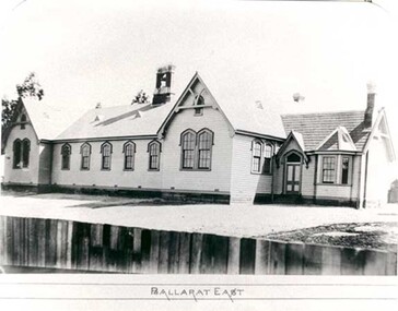 Federation University Historical Collection
Photograph - Photograph - black and white, Ballarat East State School (No 1071)
The weatherboard Ballarat East State School SS 1071 was formerly known as Specimen Hill. According to 'Visions and Realisations' The Eureka gold lead opened in August 1852, running from Little Bendigo, south beneath Yarrowee Creek into Pennyweight flat, where it was joined 100 yards or so from the intersection of main and Eureka Streets by the Canadian Lead. State School 1071 was formerly known as Ballarat Common School No. 71, and was founded by the Free Presbyterian Church on Specimen Hill in Eureka Street, Ballarat on 01 January 1854. On 20 May 1869 the trustees of the Presbyterian School, Specimen Hill, Ballarat, consented to the transfer of the site to the Board of Education. On 01 September 1870, Specimen Hill, Ballarat, was vested in the Board and then became known as SS 1071. On 01 March 1879 the Minister, The Hon. William Collard Smith, and William Dobbie, Inspector of School Buildings, visited Ballarat to report on the buildings with a view to extensions and renovations. The minister issued instructions for the old wooden part of the school to be demolished, and brick additions to be erected, so that the whole premises would accommodate 350 students. (''Visions and Realisations: A Century of State Education in Victoria, Vol. 2'', Education Department of Victoria, 1973, p 729-730.)Black and white photograph of a weatherboard school with shingle roof known as Ballarat East (SS1071). The building has a brick chimney and bell tower. This school has Castlemaine flagging in the passages.ballarat east state school, education, st paul's school, specimen hill state school -
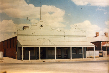 Charlton Golden Grains Museum Inc
Photograph, Victoria Hall, Armstrong St Charlton c. 1960, c.1960
Victoria Hall, Armstrong St Charlton was built for E. Miles in 1884. Sid Rosewall's house is on the right. This photo taken c. 1960.Colour photograph of a single storey, triple fronted red brick building. The front of the building is painted. There are double doors for the main entrance and three single doors - one to the left and two to the right of the main doors. There is a large, ornamental parapet wall on the front of the building with a flag pole. A wide verandah runs the length of the front of the building with a pitched section over the main entrance. The LH side of the building is unpainted and has four windows high on the wall. A red brick building is partially visible on the RH side of the photo. It has two chimneys and iron roof.e. miles, s. rosewall, victoria hall, armstrong street, charlton, halls -
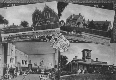 City of Ballarat Libraries
Photograph - Card Box Photographs, Photos of St Alipius School and Kindergarten and Villa Maria Sacred Heart Convent, Ballarat c1915
... buildings ...External pictures of St Alipius School and the Villa Maria Sacred Heart Convent and an interior picture of the kindergarten. These buildings are located on Victoria Street. This comes from the Ballarat Homecoming publication.st alipius, villa maria sacred heart convent, buildings, victoria street, education, catholic schools, public, ballarat, ballarat homecoming -
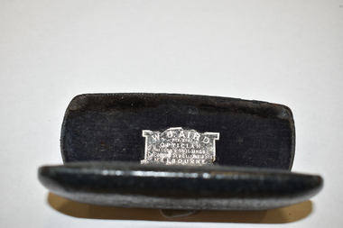 Warrnambool and District Historical Society Inc.
Accessory - Glasses Case
This glasses case would have contained a small type of spectacles or pince- nez. The original owner is unknown.This item is of minor interest and is kept for display purposes only.Dark coloured, rectangular leather case, hinged to shut tight. It has curved edges and a leather piece folded inside to hold the glasses. The inside is a deep blue velvet . The name of the optician is pasted inside . The item is somewhat scuffed.W.J. AIRD. PTY LTD OPTICIAN ALISON'S BUILDINGS CR. COLLINS ST & ELIZABETH STS. MELBOURNE vintage accessories, warrnambool history -
 Robin Boyd Foundation
Slide, Robin Boyd, 1950
Penleigh Boyd, Robin and Patricia Boyd's son, writes “Prior to 1950 Robin, like most other amateur or hobby photographers, took black and white printed photographs. The oldest slides date from 1950 when Robin and Patricia travelled to Europe on Robin’s Robert Haddon Travelling Scholarship.” In 1948 Robin Boyd was awarded ‘joint first place’ in the Robert Haddon competition for his design of Mildura art gallery. The scholarship helped fund their first overseas trip. Robin and Patricia were passengers on the Greek ship “Cyrenia” departing in May 1950, passing through the Suez Canal and landing in Genoa five weeks later. For six months, they travelled extensively throughout Europe (predominantly driving themselves) - France, Italy, United Kingdom, Sweden, Denmark, Germany, Austria, Switzerland and Spain.Colour slide in a mount. Old Court of Appeal for Western Sweden 1948, Gothenburg, Sweden. (Architect: Hakon Ahlberg.)Gothenburg / Court / Law Courts Building for West Sweden / Arch. Hakon Ahlberg / 1948 (All Handwritten)haddon travelling scholarship, haddon, robin boyd, slide -
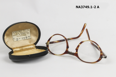 Whitehorse Historical Society Inc.
Functional object - Spectacles, folding and case, circa 1967
From the estate of Jenny Lang, 11 Pearcedale Road, NunawadingHorn rimmed spectacles which fold on the bridge of the nose and at the end of each arm. The case is brown leather with a gold satin lining.Alfred Nott Pty Ltd, T & G Building Collins & Russell Streets Melbourne D - 1967personal effects, seeing aids -
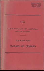 Bendigo Historical Society Inc.
Administrative record - Electoral Roll, 1915
Voting registers, or electoral rolls, are a census of those who were eligible to vote. They are valuable because a country-wide census was not taken until 1911. Early electoral rolls give an individual name, residence, status of property occupation/ownership, and the rate value of the property. Electoral rolls are arranged by electoral district and subdistrict. Name, Address, Occupation and gender for thirteen subdivisions (Bendigo, Carisbrook, Castlemaine, Eaglehawk, Elmore, Golden Square, Heathcote, Maldon, Marong, Maryborough, Raywood, Sandhurst East & Strathfieldsaye). Electoral rolls were published by each state during election years..Electoral Roll for the Commonwealth Division of Bendigo, State Assembly District of Bendigo, and State Electoral Province of Bendigo for 1952 (made up to 8th September 1952). Includes Name, Address, Occupation and gender for thirteen subdivisions (Bendigo, Carisbrook, Castlemaine, Eaglehawk, Elmore, Golden Square, Heathcote, Maldon, Marong, Maryborough, Raywood, Sandhurst East & Strathfieldsaye). Assembled and bound with string, and a red light-card cover.Stamped on cover as owned by Harold Curnow, Accountant and Auditor, Colonial mutual Building, View Street, Bendigo.electoral rolls, voting in bendigo -
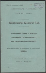 Bendigo Historical Society Inc.
Administrative record - Electoral Roll, 1915
Voting registers, or electoral rolls, are a census of those who were eligible to vote. They are valuable because a country-wide census was not taken until 1911. Early electoral rolls give an individual name, residence, status of property occupation/ownership, and the rate value of the property. Supplementary Electoral Rolls are arranged by electoral district and subdistrict. Name, Address, Occupation and gender for thirteen subdivisions. Electoral rolls were published by each state during election years.Supplementary Electoral Roll for the Commonwealth Division of Bendigo, State Assembly District of Bendigo, and State Electoral Province of Bendigo for 1952 (made up to 16th May 1952). Includes Name, Address, Occupation and gender for thirteen subdivisions. Assembled and bound with staples, and a light green card cover and pages.Stamped on cover as owned by Harold Curnow, Accountant and Auditor, Colonial mutual Building, View Street, Bendigo.electoral rolls, voting in bendigo -
University of Melbourne, Burnley Campus Archives
Slide, Alan L. Mitchell, 1965
Entrance to Old Building (1936) figure A. Mitchell. Portrait Mr. E. Prescott (Elder) Principal House.alan l. mitchell, burnley gardens -
University of Melbourne, Burnley Campus Archives
Slide, Alan L. Mitchell, 1936
Entrance to Old Building (1936) figure A. Mitchell. Portrait Mr. E. Prescott (Elder) Principal House.alan l. mitchell, burnley gardens, e. prescott, principal house -
 National Wool Museum
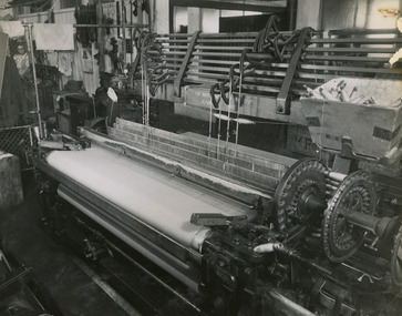
Photograph - Weaving Machine, 1960s
One of fifty one photographs originally in a photo album found in the National Wool Museum’s office. The album was water damaged and the images were removed for conservation. The images follow the process of wool. Beginning in a sheep paddock and finishing as a folded fabric. It includes all the steps in between in this process, including shearing, transporting, selling, washing and the many different steps in the process of turning a single thread of wool into fabric.Black and white image showing a weaving machine.AUSTRALIAN NATIONAL PUBLICITY / ASSOCIATION / FLINDERS STREET RAILWAY BUILDING, / MELBOURNE AUSTRALIA / W26 / W26. Weaving.wool industry, working life, women, boonoke station, farming, sheep farming, agriculture, sheep stations, transport, wool processing, shearing, textile industry, wool -
 National Wool Museum
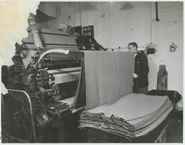
Photograph - Cropping Machine, 1960s
One of fifty one photographs originally in a photo album found in the National Wool Museum’s office. The album was water damaged and the images were removed for conservation. The images follow the process of wool. Beginning in a sheep paddock and finishing as a folded fabric. It includes all the steps in between in this process, including shearing, transporting, selling, washing and the many different steps in the process of turning a single thread of wool into fabric.Black and white image showing a cropping machine processing woollen textile. A man is shown standing near the machine.AUSTRALIAN NATIONAL PUBLICITY / ASSOCIATION / FLINDERS STREET RAILWAY BUILDING, / MELBOURNE AUSTRALIA / W31 / W31. Croppingwool industry, working life, women, boonoke station, farming, sheep farming, agriculture, sheep stations, transport, wool processing, shearing, textile industry, wool -
 National Wool Museum
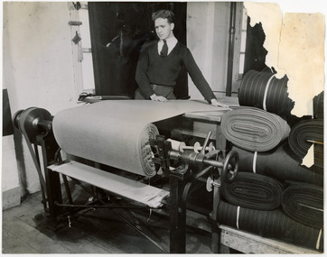
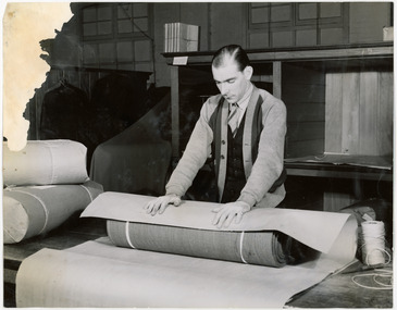
Photograph - Folding Woollen Textiles, 1960s
One of fifty one photographs originally in a photo album found in the National Wool Museum’s office. The album was water damaged and the images were removed for conservation. The images follow the process of wool. Beginning in a sheep paddock and finishing as a folded fabric. It includes all the steps in between in this process, including shearing, transporting, selling, washing and the many different steps in the process of turning a single thread of wool into fabric.Black and white image showing a man using a machine to fold woollen textiles.AUSTRALIAN NATIONAL PUBLICITY / ASSOCIATION / FLINDERS STREET RAILWAY BUILDING, / MELBOURNE AUSTRALIA / W33 / W33. Folding.wool industry, working life, women, boonoke station, farming, sheep farming, agriculture, sheep stations, transport, wool processing, shearing, textile industry, wool -
 National Wool Museum
Photograph - Packing Wool Textiles, 1960s
One of fifty one photographs originally in a photo album found in the National Wool Museum’s office. The album was water damaged and the images were removed for conservation. The images follow the process of wool. Beginning in a sheep paddock and finishing as a folded fabric. It includes all the steps in between in this process, including shearing, transporting, selling, washing and the many different steps in the process of turning a single thread of wool into fabric.Black and white image showing a man rolling and packing woollen textiles.AUSTRALIAN NATIONAL PUBLICITY / ASSOCIATION / FLINDERS STREET RAILWAY BUILDING, / MELBOURNE AUSTRALIA / W35 / W35. Packing.wool industry, working life, women, boonoke station, farming, sheep farming, agriculture, sheep stations, transport, wool processing, shearing, textile industry, wool -
 National Wool Museum
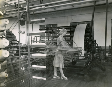
Photograph - Warping Machine, 1960s
One of fifty one photographs originally in a photo album found in the National Wool Museum’s office. The album was water damaged and the images were removed for conservation. The images follow the process of wool. Beginning in a sheep paddock and finishing as a folded fabric. It includes all the steps in between in this process, including shearing, transporting, selling, washing and the many different steps in the process of turning a single thread of wool into fabric.Black and white image showing a woman working at a warping machine.AUSTRALIAN NATIONAL PUBLICITY / ASSOCIATION / FLINDERS STREET RAILWAY BUILDING, / MELBOURNE AUSTRALIA / W24 / W24. Warping.wool industry, working life, women, boonoke station, farming, sheep farming, agriculture, sheep stations, transport, wool processing, shearing, textile industry, wool