Showing 3762 items
matching surveyed
-
 Ballarat Tramway Museum
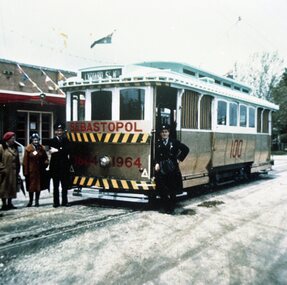
Photograph - Colour Photograph/s set of 2, V. Butler, 1964
Yields information about the tram painted for the centenary of the discovery of gold in Ballarat and the official launch of the tram. Significance would be higher if names of people known.1116 - Colour copy print of a colour photograph of SEC Ballarat No. 18 painted in gold and white for the centenary of the Borough of Sebastopol. Taken outside the Sebastopol Town Hall possibly at the time of its launch, as the driver and conductor are standing by the tram and a lady with a name tag next to one of the crew. Taken by Mrs. V. Butler in 1964 on a colour slide, from which print taken from. Tram has gold paint on the end and side panels with the "1864 1964" on the end panel and "100" on the side panel. Tram showing destination of "Lydiard St. Nth" indicating it was possibly a service tram. Tram carrying Australian flags at either end. 2nd copy of large print added 29/7/2007, from Alan Bradley 5/2007 collection of photographs. 1116.1 - the smaller original photograph noted above. Three copies held, two without border, one with border. High Res scan of copy negative added 17/1/2019 see image i1. See Reg. Item No. 1090, "Sebastopol Victoria - A Historical Survey of Early Sebastopol - 1864- 1964".sebastopol, centenaries, 18, gold, tram 18 -
 Melbourne Tram Museum
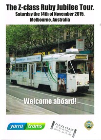
Document - Tour Notes, Yarra Trams, "The Z-class Ruby Jubilee Tour", Nov. 2015
Set of six documents issued to participants of the "The Z-class Ruby Jubilee Tour", Saturday 14/11/2015 operated by Yarra Trams, John Whiting and Melbourne Tram Museum. All have a "Z1 & Z2 Class Ruby Jubilee Tour - 40 years" stamp on them. .1 - Tour booklet 8 pages - A5 when folded - with Z101 on the cover, giving a brief history, photos of Z class trams through the years, technical details, Z class trams in preservation and acknowledgements. .2 - A4 sheet "I was on board the tour" with photos of Z1 22 and Z2 101 along with logos of the MMTB, MTA. The Met, Swanston Trams, M>Trams, Yarra Trams. .3 - A4 - "Tram Service Changes" change sheet advising the tour times, routes and service changes. .4 - Doubled sided A4 sheet giving the detail timetable for the tram tours using Z1 22 and Z2 101. .5 - A4 sheet - giving details of the Z class destinations and codes. .6 - A4 double sided, Z class ruby Jubilee tour passenger survey sheet.trams, tramways, z class, tours, logos, e class, specification, destination roll, timetables -
 Bendigo Historical Society Inc.
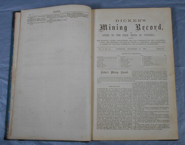
Journal - Dicker's Mining Journal 1862
Thomas Dicker, Rowan Street, Bendigo, published a monthly mining journal that included geological information, mine details and mining practises for particular mining districts. In 1868/9, Dicker moved to England to open the "Australian and London Mining Agency" with the goals of promoting investment in Victorian mines, entering Victorian mining shares on the London Stock market, and exploring the latest in mining technology that might be suitable for mining in Victoria.Dicker's Mining Record and guide to the gold mines of Victoria, showing the bearings, depths, thickness, dips and underlies of the auriferous lodes; the progress and cost of works in operation; containing also a variety of valuable interesting and statistical information. Published by the proprietor, Thomas Dicker, Rowan Street Sandhurst. A green with black spine hardcover book. Paper glued on the front with the title Dicker's Mining Journal 1862. On the spine in gold lettering Dicker's Mining Record Vol.1 1861-2. The book contains 12 issues of the Dicker's Mining Record, the first from Saturday, November 23, 1861: the last from October 24, 1862. Also, there are two pieces of paper inside front cover with writing in pencil; the first says: shaft originally No.3 shaft of the speedwell coy. in 1902 the North Normanby Coy. was formed and took over the shaft. A new winding engine was installed in 1909. 10 head battery 1905, extra 20 head in 1909. The second, also in pencil, reads: Dept. of Mines Geological survey No.4 Ballarat East goldfields - 1907 - Mr. Marbrey (?) 39 Shamrock St. Bendigo.Sticker on inside front page: Ballarat Historical Museum presented by Mr. W.H. Lewis Young Street. On second page in pencil: Mr. John N Bailey mining manager of John Woods mines Stawell, Sons of Freedom Beaufort (illegible). To Mr. John Bailey as a mark of esteem grom J. Logan.dicker's mining journal, 1862, mining -
 City of Moorabbin Historical Society (Operating the Box Cottage Museum)
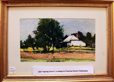
Painting, 'Spring Grove' 19thC house, c1979
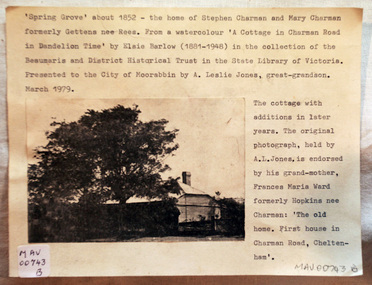
In 1852 Stephen Charman purchased 160 acres bounded by Charman Rd and Balcombe Road in an area called Spring Grove , later Cheltenham. A spring ran through the land providing a good source of water. Stephen aged 21 years had arrived in Melbourne 1842 as one of Henry Dendy’s emigrants . His Ship passage was paid by the Colonial Land and Emigration Commission and in return he was required to work on the land of the Henry Dendy Special Survey Brighton 1841. However Henry Dendy could not provide enough work for all the emigrants that arrived and Stephen had to obtain other work. Then sadly his young wife Harriett and their infant died. 1850 Stephen married widow Mary Gettens, a Publican in Little Collins Street, with 5 children. Stephen & Mary built a wattle and daub hut and established a market garden producing marigolds for Martin & Pleasance Pharmacists, Melbourne. They had 7 more children and built a weatherboard cottage that was used for early Methodist Church services. Stephen donated 1 acre to the Methodist Church in 1855 for Chapel , School and Cemetery. This is the weatherboard cottage in the painting, The road between Cheltenham and Mentone bears their name. Mary died in 1870 and Stephen remarried 1878 and died in Gippsland 1906. Stephen and Mary Charman were pioneer settlers in the area of Spring Grove later known as Cheltenham . Charman Road Cheltenham commemorates their contribution to the development of the area A painting of 'Spring Grove' the home of Stephen Charman and Mary Charman formerly Gettens nee Rees, This cottage was the first house in Charman Road Cheltenham c1852signed L Schumerspring grove cottage 1852, schumer l, cheltenham, charman stephen, early settlers, jones a l , gettens mary, rees mary, charman mary, moorabbin, brighton, -
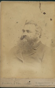 Uniting Church Archives - Synod of Victoria
Photograph
Rev. Peter Thompson (1847 - 1909) was Superintendent of the East End Wesleyan Mission. Entered the Wesleyan ministry in 1871. Died 1909. The second son of a Lancashire farmer, Peter grew up in a tee-total Methodist household with a rather austere father and a saintly mother. He trained at Didsbury Wesleyan College where he was, by all accounts, a brilliant student. He was stationed in Ulverston and then Huddersfield (by 1876). By 1881 Peter had married and was Minister at Wood Green. He and his wife, Mary, do not appear to have had any children. They spent some years in Redhill and then, following the decision of Conference in 1885 to establish the London Wesleyan Methodist Mission, Peter was sent to the East End of London to take charge of the almost defunct St George’s Wesleyan Chapel. His work as a slum missionary was so successful that soon larger premises were required. In addition the mission took over a ‘most undesirable’ public house (The White Swan on Ratcliffe Highway) and later, in 1891, the Mahogany Bar. In 1898 he was interviewed by Charles Booth as part of Booth’s survey of London. Peter died after a long illness in 1909 having served 24 years in East London, one of the best known and loved Wesleyan ministers of his time. Sepia toned head and shoulders studio portrait of the Rev. Peter Thompson.rev peter williams, methodist, wesleyan, minister, east end mission -
 Eltham District Historical Society Inc
Photograph, Liz Pidgeon, Heritage Excursion; The 1901 Eltham Railway Walk, 3 May 2014
Football match at Eltham Central Park between Eltham and Heidelberg Newsletter No. 216, May 2014 May Excursion – The 1901 Eltham Railway Walk The railway from Heidelberg to Eltham was opened in 1902. Over the previous year railway construction cut a curving swathe through Josiah Holloway’s 1851 Little Eltham subdivision. The survey plans for the railway show the owners and occupiers of land within Little Eltham affected by the railway alignment and for some distance each side. The plans show houses and other buildings but development at that time was rather sparse. Copies of these plans from the State Library of Victoria collection have been provided to the Society by Alan Sheehan. For our walk on 3rd May we intend to follow the railway from the Eltham Station to Ryans Road, which was the boundary of the adjoining Montmorency Farm. The return will be by way of nearby streets. Along the way we will discuss the details shown on the railway plans as well as more recent railway documents and photographs. At the conclusion and if time permits we can inspect the historical display at the Eltham Station. The walk is about 3 km in length and will take about 2.5 hours. It will start at 2 pm at the Eltham Railway Station car park (east/Main Road side) (Melway Ref. 21 J5).Born Digitalheritage excursion, activities, eltham district historical society, eltham railway station, eltham library, trestle bridge, eltham central park, football -
 Melton City Libraries
Pamphlet, Dry Stone Wall Driving Trail, Unknown
"The dry stone walls provide a tangible link to the area’s white settlement, and they remain a symbol of the profound change in land usage from the original Kulin custodians to the European arrivals of the nineteenth century. The bulk of dry stone wall construction in Victoria occurred between the 1850s and 1880s. The gold rush of the early 1850s in particular inspired a flurry of construction. At this time, labour previously available for shepherding livestock dried up, as men gravitated to the goldfields to seek their fortunes. This necessitated the building of fencing to contain the district’s growing number of sheep, cattle and horses. An explosion in surveying, subdivision and the sale of Crown lands also contributed to a boost in construction. Government regulations that punished pastoralists for allowing their livestock to stray provided further incentive to fence-off previously open expanses of land. The major benefit of this type of fencing was that it utilised the materials at hand; the plentiful grey basalt that scattered the landscape. In the case of the dry stone walls built around Melton, the characteristic round or oval shape of the volcanic fieldstones on the western plains inspired some distinctive designs.54 Another advantage of dry stone walls was their ability to withstand the ravages of flood, fire and drought often experienced in the district. This durability accounts for the fact that many of these fences still exist today". Dry Stone Wall trail brochure/pamphlet for visitors provided by Melton Visitor Information Centrecouncil, landscapes of significance -
 National Wool Museum
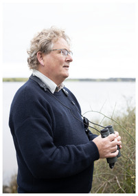
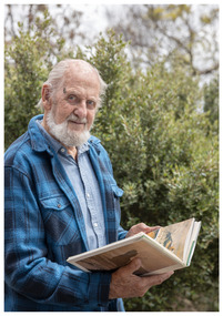
Photograph - Portrait of Dr John Newman, Nicole Marie, 2021
Thousands of volunteers work tirelessly to conserve and protect the environment of Geelong and the Bellarine. Their work often goes unnoticed. In 'The Work of Nature' the National Wool Museum and the Environment Department at the City of Greater Geelong worked with photographer Nicole Marie to showcase the significant contribution of environment volunteers in our region. Each of the eight people showcased in these portraits were nominated by their peers and members of the community for their significant contribution to conserving and protecting the environment. Dr John Newman - Geelong Field Naturalists Club Over almost twenty years John Newman has organised large groups of volunteers to conduct surveys across Geelong and the Bellarine for shorebirds and waterbirds. Understanding and collecting important environmental data helps in the effort to preserve important sites, much of this data is collected by volunteers. The information collected in Geelong and the Bellarine also forms part of national and international datasets that helps in understanding global patterns of migratory birds, such as sharp-tailed sandpiper, red-necked stint and the critically endangered curlew sandpiper. The data collected at the Moolap Saltworks (since 1981) and co-ordinated by John since 2003 highlighted the importance of this site for these three species and played a crucial role in protecting the area as a conservation site. Photo at Taits Point, Lake Connewarre Wildlife Reserve by Nicole Marie.Image showing an environmental portrait of a man holding binoculars with a water landscape in the background.environment, conservation, portraits, geelong, nature, exhibition, work of nature, geelong nature forum, volunteers, lake connewarre -
 Glen Eira Historical Society
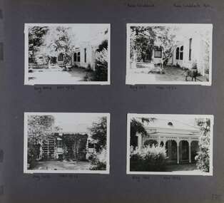
Album - Album page, Rose Craddock, Rose Craddock Avenue, Circa 1972
This photograph is part of the Caulfield Historical Album 1972. This album was created in approximately 1972 as part of a project by the Caulfield Historical Society to assist in identifying buildings worthy of preservation. The album is related to a Survey the Caulfield Historical Society developed in collaboration with the National Trust of Australia (Victoria) and Caulfield City Council to identify historic buildings within the City of Caulfield that warranted the protection of a National Trust Classification. Principal photographer thought to be Trevor Hart, member of Caulfield Historical Society. Most photographs were taken between 1966-1972 with a small number of photographs being older and from unknown sources. All photographs are black and white except where stated, with 386 photographs over 198 pages. From Victorian Heritage Database citation for HO16 Rosecraddock 4-10 Craddock Avenue and 2-8 Keverell CAULFIELD NORTH https://vhd.heritagecouncil.vic.gov.au/places/35279 as at (30/10/2020) - the City of Glen Eira Heritage listing "Rosecraddock" is regionally important as a surviving large villa from the early Victorian (1850's) period, offering insight into the lifestyles of the privileged in Caulfield at that time. Its importance is enhanced through its long association with the Langdon family and, in particular, Henry Joseph Langdon, founder of H.J. Langdon and Company, China merchants. There is a separate statement of significance at https://vhd.heritagecouncil.vic.gov.au/places/277 for H0589 Rosecraddock 2-8 KEVERELL ROAD and 4-10 CRADDOCK AVENUE CAULFIELD NORTH - Victorian Heritage RegisterPage 176 of Photograph Album with four photographs of Rose Craddock.Handwritten: "Rose Craddock" Rose Craddock Ave. [top right] / Neg 204 Nov 1972 [under top left photo] / Neg 193 Nov 1972 [under top right photo] / Neg 208 Nov 1972 [under bottom left photo] / Neg 194 Nov 1972 [under bottom right photo] / 176 [bottom right]trevor hart, chimneys, porch, rose craddock, rosecraddock, 1850's, henry joseph langdon, h.j. langdon, h.j. langdon and company, china merchants, rosecraddock place, mansion, slate roof, return verandah, decorative brackets, cast iron lacework, keverell road, caulfield north, early victorian style, protruding bay windows, cast iron work, gardens, craddock avenue -
 Glen Eira Historical Society
Document - CAULFIELD RSL
This file contains two items pertaining to the property housing the Caulfield RSL: 1/A photocopy (2 pages) of an assessment of the property, dated 01/1997, by Andrew Ward, for purposes of ascertaining its historical significance. The assessment describes the architectural features of the property, offers a brief history of it, specifies why it should be considered significant, and recommends that it be added to the National Estate Register. Included is a black-and-white photograph of the exterior of the building. 2/An assessment (17 long pages plus appendix) of the car parking issues procured as a result of the decision to refurbish the Caulfield RSL. Prepared by Grogan Richards Pty Ltd, dated 13/11/2002, reviewed by Joanna Gauetty, and authorised by Rody Jude. Included is a description of the Club’s location and surrounding motorways as they existed at the time, a description of the Club itself (eg its opening hours and rate of patronage as per each opening hour), occupancy surveys, descriptions of other recent car parking construction within the same area, a description of the extensions the RSL is aiming to construct, and descriptions of the considerations any new construction must take into account. Included is a black-and-white map of Caulfield noting the RSL’s location, and two black-and-white photographs showing the view to the north and south of St. George’s Road, respectively.caulfield, caulfield returned servicemen league (rsl), exservice organisations, clubs and associations, ward andrew, glen eira heritage management plan, historic buildings, architectural, styles, national trust company, st. leonard’s, elsternwick club, grogan richards pty ltd, returned servicepeople, armed forces, soldiers, aged people, senior citizens centres, st. george’s road, elsternwick, english domestic revival style, moderne style, brick houses, bay windows, architectural features, prendergast ellen mrs., ford grylis, dl design group, gauetty joanna, jude rody, parking, glen eira planning scheme -
 Glen Eira Historical Society
Album - Album page, St Stephen's Presbyterian Church, Balaclava Road, Circa 1972
This photograph is part of the Caulfield Historical Album 1972. This album was created in approximately 1972 as part of a project by the Caulfield Historical Society to assist in identifying buildings worthy of preservation. The album is related to a Survey the Caulfield Historical Society developed in collaboration with the National Trust of Australia (Victoria) and Caulfield City Council to identify historic buildings within the City of Caulfield that warranted the protection of a National Trust Classification. Principal photographer thought to be Trevor Hart, member of Caulfield Historical Society. Most photographs were taken between 1966-1972 with a small number of photographs being older and from unknown sources. All photographs are black and white except where stated, with 386 photographs over 198 pages. From: Glen Eira Heritage Management Plan (1996) by Andrew Ward and Associates: In 1905, the land was vacant in Balaclava Road, north side, from Kooyong Road east to the right of way, except for one house. A block of this land was acquired by the Presbyterian community and a timber church erected there in 1910. In time, a larger church was required. After several years of fund raising led by George Kinross, a new red brick St Stephen's church was built in 1926 to the design of architects Haddon and Henderson. George Currie was the builder and the cost of construction was £5,100.Glen Eira Heritage Management Plan 1996 by Andrew Ward St Stephens has architectural importance as a noteworthy example of a Gothic Transitional design in the Arts and Crafts eclectic manner (see Stylistic Typology in National Trust's Historic Church's Study}. The facade treatment successfully combines Christian symbols with Gothic forms in the Arts and Crafts mode (comparable with Haddon's Presbyterian Church, Malvern (1906) and Haddon and Henderson's Oakleigh Church (1928). It is locally important as an example of Robert Haddon's work in Caulfield, where he also lived (4 Glenferrie St q.v.).Page 24 of Photograph Album with four black and white photographs of St Stephen's Presbyterian Church, with Balaclava Road written on the top right hand side. Three photos are of the exterior and one is a wide view of the inside towards the altar.Hand written: St Stephen's Presbyterian Church Balaclava Road [top right of page] / 24 [bottom right]trevor hart, caulfield north, balaclava road, george kinross, haddon and henderson, george currie, st stephen's, 1900's, 1920's, gothic transitional, christian symbols, arts and crafts, robert haddon, stylistic typology, gothic, presbyterian church, architects, red bricks, entrances -
 Glen Eira Historical Society
Album - Album page, St Stephen's Presbyterian Church, Balaclava Road, Circa 1972
This photograph is part of the Caulfield Historical Album 1972. This album was created in approximately 1972 as part of a project by the Caulfield Historical Society to assist in identifying buildings worthy of preservation. The album is related to a Survey the Caulfield Historical Society developed in collaboration with the National Trust of Australia (Victoria) and Caulfield City Council to identify historic buildings within the City of Caulfield that warranted the protection of a National Trust Classification. Principal photographer thought to be Trevor Hart, member of Caulfield Historical Society. Most photographs were taken between 1966-1972 with a small number of photographs being older and from unknown sources. All photographs are black and white except where stated, with 386 photographs over 198 pages. From: Glen Eira Heritage Management Plan (1996) by Andrew Ward and Associates In 1905, the land was vacant in Balaclava Road, north side, from Kooyong Road east to the right of way, except for one house. A block of this land was acquired by the Presbyterian community and a timber church erected there in 1910. In time, a larger church was required. After several years of fund raising led by George Kinross, a new red brick St Stephen's church was built in 1926 to the design of architects Haddon and Henderson. George Currie was the builder and the cost of construction was £5,100.From: Glen Eira Heritage Management Plan (1996) by Andrew Ward and Associates: St Stephens has architectural importance as a noteworthy example of a Gothic Transitional design in the Arts and Crafts eclectic manner (see Stylistic Typology in National Trust's Historic Church's Study}. The facade treatment successfully combines Christian symbols with Gothic forms in the Arts and Crafts mode (comparable with Haddon's Presbyterian Church, Malvern (1906) and Haddon and Henderson's Oakleigh Church (1928). It is locally important as an example of Robert Haddon's work in Caulfield, where he also lived (4 Glenferrie St q.v.).Page 25 of Photograph Album - four black and white photographs of St Stephen's Presbyterian Church, with two photographs in landscape mode across the top showing information about who designed the building in one and showing the church name and year founded in the other; and two in portrait mode in the bottom section showing 2 different heavy wooden doors.Hand written: 25 [bottom left]trevor hart, caulfield north, balaclava road, george kinross, haddon and henderson, george currie, st stephen's, 1900's, 1920's, gothic transitional, christian symbols, arts and crafts, robert haddon, stylistic typology, gothic, presbyterian church, architects, red brick, doors, memorials -
 Glen Eira Historical Society
Album - Album page, St Stephen's Presbyterian Church, Balaclava Road, Circa 1972
This photograph is part of the Caulfield Historical Album 1972. This album was created in approximately 1972 as part of a project by the Caulfield Historical Society to assist in identifying buildings worthy of preservation. The album is related to a Survey the Caulfield Historical Society developed in collaboration with the National Trust of Australia (Victoria) and Caulfield City Council to identify historic buildings within the City of Caulfield that warranted the protection of a National Trust Classification. Principal photographer thought to be Trevor Hart, member of Caulfield Historical Society. Most photographs were taken between 1966-1972 with a small number of photographs being older and from unknown sources. All photographs are black and white except where stated, with 386 photographs over 198 pages. From: Glen Eira Heritage Management Plan (1996) by Andrew Ward and Associates In 1905, the land was vacant in Balaclava Road, north side, from Kooyong Road east to the right of way, except for one house. A block of this land was acquired by the Presbyterian community and a timber church erected there in 1910. In time, a larger church was required. After several years of fund raising led by George Kinross, a new red brick St Stephen's church was built in 1926 to the design of architects Haddon and Henderson. George Currie was the builder and the cost of construction was £5,100.From: Glen Eira Heritage Management Plan (1996) by Andrew Ward and Associates: St Stephens has architectural importance as a noteworthy example of a Gothic Transitional design in the Arts and Crafts eclectic manner (see Stylistic Typology in National Trust's Historic Church's Study}. The facade treatment successfully combines Christian symbols with Gothic forms in the Arts and Crafts mode (comparable with Haddon's Presbyterian Church, Malvern (1906) and Haddon and Henderson's Oakleigh Church (1928). It is locally important as an example of Robert Haddon's work in Caulfield, where he also lived (4 Glenferrie St q.v.).Page 26 of Photograph Album including three black and white photographs of St Stephen's Presbyterian Church, with two photographs in portrait mode across the top showing 2 different stained glass windows from the inside; and one in landscape mode in the bottom section which appears to be a photograph of a framed photograph or drawing of the church.Hand written: St Stephen's Presbyterian Church Balaclava Road [top right] / 26 [bottom right]trevor hart, caulfield north, balaclava road, george kinross, haddon and henderson, george currie, st stephen's, 1900's, 1920's, gothic transitional, christian symbols, arts and crafts, robert haddon, stylistic typology, gothic, drawings, presbyterian church, architects, lead lights, stained glass windows -
 Glen Eira Historical Society
Album - Album page, St Stephen's Presbyterian Church, Balaclava Road, Circa 1972
This photograph is part of the Caulfield Historical Album 1972. This album was created in approximately 1972 as part of a project by the Caulfield Historical Society to assist in identifying buildings worthy of preservation. The album is related to a Survey the Caulfield Historical Society developed in collaboration with the National Trust of Australia (Victoria) and Caulfield City Council to identify historic buildings within the City of Caulfield that warranted the protection of a National Trust Classification. Principal photographer thought to be Trevor Hart, member of Caulfield Historical Society. Most photographs were taken between 1966-1972 with a small number of photographs being older and from unknown sources. All photographs are black and white except where stated, with 386 photographs over 198 pages. From: Glen Eira Heritage Management Plan (1996) by Andrew Ward and Associates In 1905, the land was vacant in Balaclava Road, north side, from Kooyong Road east to the right of way, except for one house. A block of this land was acquired by the Presbyterian community and a timber church erected there in 1910. In time, a larger church was required. After several years of fund raising led by George Kinross, a new red brick St Stephen's church was built in 1926 to the design of architects Haddon and Henderson. George Currie was the builder and the cost of construction was £5,100.From: Glen Eira Heritage Management Plan (1996) by Andrew Ward and Associates: St Stephens has architectural importance as a noteworthy example of a Gothic Transitional design in the Arts and Crafts eclectic manner (see Stylistic Typology in National Trust's Historic Church's Study}. The facade treatment successfully combines Christian symbols with Gothic forms in the Arts and Crafts mode (comparable with Haddon's Presbyterian Church, Malvern (1906) and Haddon and Henderson's Oakleigh Church (1928). It is locally important as an example of Robert Haddon's work in Caulfield, where he also lived (4 Glenferrie St q.v.).Page 27 of Photograph Album with one photograph of a drawing or perhaps a postcard of St Stephen's Presbyterian Church. It has a large block of formal writing in the bottom right corner which looks official.Hand written: 27 [bottom right]trevor hart, caulfield north, balaclava road, george kinross, haddon and henderson, george currie, st stephen's, 1900's, 1920's, gothic transitional, christian symbols, arts and crafts, robert haddon, stylistic typology, gothic, presbyterian church, architects, drawings -
 Eltham District Historical Society Inc
Photograph, Liz Pidgeon, Heritage Excursion; The 1901 Eltham Railway Walk, 3 May 2014
EDHS Member Doug Orford stands by a yarn bombing installation. ewsletter No. 216, May 2014 May Excursion – The 1901 Eltham Railway Walk The railway from Heidelberg to Eltham was opened in 1902. Over the previous year railway construction cut a curving swathe through Josiah Holloway’s 1851 Little Eltham subdivision. The survey plans for the railway show the owners and occupiers of land within Little Eltham affected by the railway alignment and for some distance each side. The plans show houses and other buildings but development at that time was rather sparse. Copies of these plans from the State Library of Victoria collection have been provided to the Society by Alan Sheehan. For our walk on 3rd May we intend to follow the railway from the Eltham Station to Ryans Road, which was the boundary of the adjoining Montmorency Farm. The return will be by way of nearby streets. Along the way we will discuss the details shown on the railway plans as well as more recent railway documents and photographs. At the conclusion and if time permits we can inspect the historical display at the Eltham Station. The walk is about 3 km in length and will take about 2.5 hours. It will start at 2 pm at the Eltham Railway Station car park (east/Main Road side) (Melway Ref. 21 J5).Born Digitalheritage excursion, activities, eltham district historical society, eltham railway station, eltham library, trestle bridge, yarn bombing, doug orford -
 Bendigo Military Museum
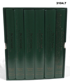
Book - BOOKS, BOXED SET OF 6, Graham R McKenzie - Smith, The Unit Guide, 2018
Boxed set of 6 books. The Unit Guide, The Australian Army 1939 - 1945. .1) Box, open, cardboard, dark green buckram, white paper lining, gold print on sides. .2) - .7) Hard cover book, cardboard, dark green buckram with gold print on front cover & spine. Pages plain cut, black print, black & white illustrations. .2) 483 pages. .3) 605 pages. .4) 626 pages. .5) 654 pages. .6) 706 pages. .7) 568 pages..2) Volume 1 of 6. Unit & Location Indexes, Bibliography, Orders of Battle .3) Volume 2 of 6. Headquarters, Infantry, Cavalry, Armoured & Intelligence Units. .4) Volume 3 of 6. Artillery, Air Defence & Engineer Units. .5) Volume 4 of 6. Medical & Signals Units. .6) Volume 5 of 6. Aust Army Service Corp, Aust Army Ordnance Corp & Aust Electrical & Mechanical Engineer Units. .7) Volume 6 of 6. Women's Services, Volunteer Defence Corps, War Graves Survey, Labour Salvage, Military Policing, Recruiting & Training, Dental, Bath & Laundry, Veterinary & Animal, Movements & Transit, Pay, Records & Printing & Postal, Amenities & Canteens Units.books-military-history, units, 1939 - 45 -
 City of Moorabbin Historical Society (Operating the Box Cottage Museum)
Buildings, Shingles Original Cottage c1850, c1850
The original small, pioneer cottage was built in the late 1840s to early1850s, by an unknown pioneer. It was located on part of a 30 Acre allotment that was originally part of Henry Dendy’s 'Special Survey Brighton' granted in 1841 (5120acres). There is a small display of external cladding shingles from the original pioneer cottage. Wooden shingles were usually thin (3⁄8 to 3⁄4 in or 10 to 19 mm), relatively narrow (3 to 8 in or 76 to 203 mm), of varying length (14 to 36 in or 360 to 910 mm), and almost always planed smooth. The traditional method for making wooden shingles was to rive - hand split - them from straight-grained knot-free sections of logs pre-cut to the desired length known as bolts. These bolts were quartered or split into wedges. A mallet and axe were used to split out thin pieces of wood. The wood species varied according to available local woods, but only the more durable inner section of the log was usually used. The softer sapwood generally was not used because it deteriorated quickly. Because hand-split shingles were somewhat irregular along the split surface, it was necessary to dress or plane the shingles to make them fit evenly on the roof. This reworking was necessary to provide a tight-fitting roof over typically open shingle lath or sheathing boards. These are the original shingles found on Box Cottage by L Lewis 1970 and used in the reconstruction in 19843 x wood Shingles used on roof of Box Cottage c 1850box cottage museum ormond, henry dendy special survey brighton 1841, brighton, moorabbin shire, parish of moorabbin, county of bourke,cottages, pioneers, ormond, colonial, mckinnon, dendy henry, box william, box elizabeth, reitman william, convicts, lewis timber co. ltd., deam h, museums, box alonzo, smith a, -
 City of Moorabbin Historical Society (Operating the Box Cottage Museum)
Clothing - Clothing, City of Moorabbin Tie, Circa 1960s
The City of Moorabbin existed from 1934 until 1994. Henry Dendy's Special Survey in 1841 of 5,120 acres in the Parish of Moorabbin , extended from Port Phillip Bay , then East to Boundary Road, South to South Road and North to North Road and became known as Brighton. 1859 Brighton became a Borough with its boundary Thomas Street ,and Bluff Road. In 1862 The Moorabbin Roads Board was formed and the extended area now included Cheltenham, Hampton, Sandringham, Black Rock, Beaumaris, Mentone and Mordialloc .and Little Brighton became known as Bentleigh. In 1871 the area became known as The Shire of Moorabbin. Gradually the area was separated into The Borough of Sandringham 1917, ( Black Rock, Beaumaris , Sandringham and Hampton ) Borough of Mentone and Mordialloc 1920, ( Parkdale ). In 1934 The City of Moorabbin was established for the area from South East corner of Thomas Street and North Road , East to Warrigal Road, Clayton Road, Kingston Road , Lower Dandenong Road, then South along Nepean Highway to Balcombe Road and along Bluff Road, Cummins Road, Nepean Highway, Thomas Street to North Road In the 1994 Amalgamation of Councils the City of Moorabbin was divided between the new City of Kingston in the South ( from South Road) and the new City of Glen Eira to the North . It was the largest Municipality in Victoria with a population of 118,865 in 1974This tie c 1960 is a memento of the City of Moorabbin 1934 - 1994Maroon colour, polyester, man's tie with the crest of City of Moorabbin woven on front.around circle enclosing Coat of Arms ; CITY OF MOORABBIN city of moorabbin, moorabbin roads board, moorabbin, brighton, dendy's special survey 1841, early settlers, pioneers, market gardners, dendy henry, were jonathan b, cheltenham, bentleigh, mentone, sandringham, mair william, bent thomas -
![Print - Artwork, David Frazer, The Text Message [study] by David Frazer, 2015](/media/collectors/530576742162ef0fa09a2288/items/5695ba972162f1130461887c/item-media/5aba2d9e21ea6d0bbcba1e3a/item-fit-380x285.jpg) Federation University Art Collection
Federation University Art CollectionPrint - Artwork, David Frazer, The Text Message [study] by David Frazer, 2015
David FRAZER (1966- ) Born Foster, Victoria, Australia David Frazer works in painting, wood engraving, etching, lithography and bronze. He studied a B.A. Fine Arts (Painting) at Phillip Institute of Technology, followed by a Diploma of Education (Secondary- Art/Craft) at Latrobe University in 1991. He completed an Honours Degree in Fine Art (Printmaking (at Monash University in 1996, and between 1998 and 2000 Frazer undertook a Master of Arts (Visual Arts) by research: “Pastoral Melancholia”, at Monash University. One of Austalia's foremost printmakers David Frazer's highly detailed woodblock and linocut prints often explore the emotional and fragile state of the human condition. His work offers a nostalgic image of Australia through its examinations of landscape, Australian buildings, sheds, and itinerant travellers. He has held seven solo exhibitions between 1996-2006 in Melbourne, Sydney and a survey show curated by the Horsham Gallery, which toured Victorian regional galleries from 2004-2005. David Frazer’s work was seen in 37 group exhibitions between 1996-2006 including the 5th British International Miniature Print Exhibition in the UK, in the 2003. He more recently held a solo exhibition with Rebecca Hossack in London 2011. (http://www.thestockrooms.com/, accessed 06/03/2015) David was awarded the Keith Wingrove Bookplate Design and in 2002.Framed limited edition linocut on paper.lls '2/36' lc 'The Text Message (study)' lrs 'D. Frazer 15'artist, artwork, david frazer, parallel prints, printmaking, linocut -
Federation University Art Collection
Artwork - Bookplates, Suit of wood engraved bookplates by David Frazer
David FRAZER (1966- ) Born Foster, Victoria, Australia David Frazer works in painting, wood engraving, etching, lithography and bronze. He studied a B.A. Fine Arts (Painting) at Phillip Institute of Technology, followed by a Diploma of Education (Secondary- Art/Craft) at Latrobe University in 1991. He compled an Honours Degree in Fine Art (Printmaking( at Monash University in 1996, and between 1998 and 2000 Frazer undertook a Master of Arts (Visual Arts) by research: “Pastoral Melancholia”, at Monash University. David Frazer’s work offers a nostalgic image of Australia through its examinations of landscape, Australian buildings, sheds, and itinerant travellers. He held seven solo exhibitions between 1996-2006 in Melbourne, Sydney and a survey show curated by the Horsham Gallery, which toured Victorian regional galleries from 2004-2005. David Frazer’s work was seen in 37 group exhibitions between 1996-2006 including the 5th British International Miniature Print Exhibition in the UK, in the 2003. He more recently held a solo exhibition with Rebecca Hossack in London 2011. (http://www.thestockrooms.com/, accessed 06/03/2015) These two wood engravings are the subject of the forthcoming Private Press book: ‘The Bookplates of David Frazer’ written by Robert C. Littlewood, The Lytlewode Press, Chateau Bosgouet, Normandie, France, 2014/2015. david frazer, bookplate, wood engraving, printmaking -
 Eltham District Historical Society Inc
Folder, Eltham War Memorial Garden and Property; Notes compiled by Harry Gilham, 1996-1997
Contents: 1. Notes concerning impact upon Eltham War Memorial Garden of a proposed roundabout at Dudley Street, Eltham, September 1996 - In 1996 Nillumbik Shire Council proposed the provision of traffic lights or a roundabout to alleviate traffic concerns at the intersection of Main Road with Dudley street and Panther Place. The Society had no real concerns with Panther Place as it had no perceived impact upon Shillinglaw Cottage however survey pegs for a new road alignment to provide for a roundabout at Dudley Street were placed within the Eltham War Memorial Gardens which was significant concern. Harry Gilham, then President of the Society was on the working group with Council and the RSL to discuss this proposal. Ultimately it did not proceed and traffic lights were installed. No action occurred at Panther Place. 2. Notes pertaining to Eltham Town Focus Group and the Eltham War Memorial Trust property, c.January 1997 - These notes from Harry Gilham relate to a draft report "A Community Vision for 'The Eltham War Memorial Trust' Property Main Road, Eltham" being prepared at the request of Chief Commissioner Don Cordell, Nillumbik Shire Council, 31st January 1997. Harry handed over these notes to Jim Connor on 14 March 2010. Jim had replaced Harry as President of the Eltham District Historical Society in 2009. They also reference Stanley S. Addison's Outline History of the Eltham War Memorial Trust30 pages of various types, mainly A4, printed and with notes by hand or handwritten notes (drafts)chief commissioner don cordell, dudley street, eltham rsl sub-branch, eltham town focus group, eltham war memorial garden, eltham war memorial trust, main road, panther place, returned services league, roundabouts, shire of nillumbik, stanley s addison -
 Eltham District Historical Society Inc
Document, Samantha Westbrooke Pty Ltd et al, 2 Bell Street, Eltham: Cultural Heritage Significance Assessment & Heritage Guidelines for Future Use & Development, 2012
Prepared for Nillumbik Shire Council by Samantha Westbrooke Pty Ltd in association with Peter Mills PhD, Architectural Historian and Roark Muhlen-Schilte, Archaeologist. Covers history of early market gardening in Eltham with the commencement of European settlement in the late 1830s. The site for the village of Eltham was surveyed in 1851 and the Township Plan shows that the property is made up of Lots 7 and 8 which were sold at auction in June 1852 to M. O'Shea. The history of the Bell Street property is closely tied to the West family from the 1860s to 1930s; the earliest rate books for Eltham show William West farming in El;tham in 1864. In the aerly 1930s ownership of the creek side was transferred from the west family to the Fabbro family who shortly afterwards were impaced by the 1934 Diamond Creek flooding. Guido Fabbro relocated the original West home further up the hill and built a new Italianate style modern home in situ. The Fabbro family farmed the property. In 1993/4 Eltham Council acquired the creek-side market garden blocks to the south of 2 Bell Street which was recconceived in 1998 as the Barak Bushland Reserve. The Fabbro house was demolished shortly after and the lots were sold to a developer in 1994. The large steel shed now present on the 2 Bell Street property dates from soon after this sale.26 A4 pages color printcultural heritage significance assessment, peter mills, samantha westbrooke pty ltd, shire of nillumbik, 2 bell street, eltham, market gardening, west family, fabbro family, land use, barak bushland reserve, heritage assessment -
 Melbourne Legacy
Article, Bulletin VALE Legatee Jim Gillespie, 1987
An article from the Melbourne Legacy Bulletin on the death of Legatee James George Gillespie, a long serving Legatee, on 21st May 1987. The Bulletin published articles on Legatees when they passed away. The article includes a snapshot of his life and career as a surveyor and long history of service in many fields. He was a member of the RMIT Council, on the board of he Royal Women's Hospital - both of whom named building after him. He served on the Hospitals and Charities Commission, and the Nurses Memorial Centre and Greenvale Geriatric Centre. Plus many more. He enlisted in the AIF 18 months after his older brother had been killed on the first day of the landing at Gallipoli. He was in the 46th Battery, 12th Artillery Brigade as a gunner. He served in France and Belgium and was in Paris on the day the Armistice was signed. In World War 2 he was called up and was appointed Assistant-Director of Survey, with a rank of Lieut-Colonel. Jim Gillespie joined Legacy in June 1928, being nominated by Frank Doolan and seconded by Harold Peters. He filled many posts, including vice-president in 1937 and President in 1938 The article was part of an folder about of past presidents that served on the LCC in preparation for the photo board that was produced. The folder included biographical details and obituaries, eulogies and death notices of some Legatees. The items have been catalogued separately.A record of the life and service of Legatee Jim Gillespie. The information was published in the Bulletin and collected to record the lives of prominent legatees in a folder.Typed copy of 4 pages from the Legacy Bulletin on the death of Legatee James Gillespie.Bulletin No. VAW 1209. 28.5.1987. Pages 2 to 5.vale, eulogy, past presidents, jim-gillespie -
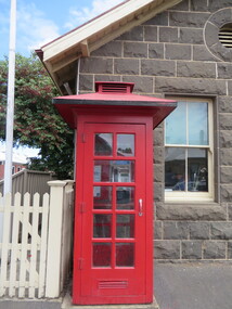 Ballarat Heritage Services
Photograph - Photograph - Colour, Clare Gervasoni, Koroit Post Office, 2015, 21/12/2015
The town borrows its name from the Koroitch Gundidj people who occupied the area prior to European settlement. (https://en.wikipedia.org/wiki/Koroit, accessed 21 December 2016) Koroit was first surveyed as a township in 1847. Around the 1850 the district had the highest population of Irish immigrants in rural Australia. The Koroit Post Office was designed by architect and engineer John Mason of Port Fairy. (Moyne Shire Heritage Study 2006 Stage 2, Volume 2: Environmental History, Prepared for Moyne Shire Council Helen Doyle in association with Context Pty Ltd, 2006.) Rosebrook Bridge, Rosebrook (1853; replaced) Post Office buildings, Bank Street, Port Fairy (c.1857) The author Henry Handel Richardson lived in the Koroit Post Office as a child after her family moved to Koroit in 1878. Remembering Koroit from her youth, the third volume in her The Fortunes of Richard Mahony trilogy is set in the town. When the author was six, her father Walter died in Koroit on 1 August 1879 and was buried at the Koroit cemetery. (https://en.wikipedia.org/wiki/Koroit, accessed 21 December 2016) In 1878 Mary Richardson was appointed postmistress of the Koroit Post Office at a salary of 72 pounds with free quarters, firewood and kerosene. She lived at the back of the Post Office. (From a Green and Pleasant Land by H. McCorkell and P. Yule.) Photographs showing the bluestone Koroit Post Office, phone box and postbox. It is located at 99 Commercial Road, Koroit. "Historic Area Statement of Significance: The significance of Koroit derives from its role as the urban centre of one of the most concentrated Irish Roman Catholic rural districts in Australia, noted for its mixed livestock and cropping argicultural patterns. This is reflected in two separate and distinctive areas in the town - the administrative/commercial area and the church precinct. The administrative and commercial area (focussing on the Boundary-Commercial Road/High Street intersection and the Koroit Hotel) consists of a number of significant public buildings and leads to a street of relatively intact humble shopfronts and kerbline verandahs, visually punctuated by opposing bank facades. The church precinct is dominated by a group of Catholic buildings larger in scale and more complete in range than those in any comparably sized Victorian town." http://vhd.heritagecouncil.vic.gov.au/places/69338#sthash.ELLuSMvg.dpuf, accessed 21 December 2016."koroit, post office, phone box, payphone, bluestone, henry handel richardson, koroit post office -
 Ballarat Heritage Services
Photograph - Colour, Bessibelle Drystone Sheep Wash, 2016, 24/04/2016
The Bessiebelle Sheepwashes and Yards complex is located on the former 14,000 acre Ardonachie Run, established in 1848 by pastoralist Samuel Gorrie, then carrying 6,000 sheep. In 1864 this run was subdivided into smaller runs, and the sheep washes were located within Mount Eccles and Lake Gorrie Run. The date of construction of the washes and walls is not known, although they were probably constructed within the period 1848-1864. The Bessiebelle Sheepwashes and Yards are probably the largest and most sophisticated surviving example of a traditional pastoral property sheepwash in Victoria. They clearly demonstrate the large network of races, yards and folds necessary for washing thousands of sheep over a short period of time. The Bessiebelle sheep washes apparently predate later technological changes and the necessity for hot water washing. The Bessiebelle sheepwashes and yards are of landscape significance as a cultural landscape which has been both modified by, and cleverly adapted to, an annual process that was of critical importance within the pastoral calendar. The drystone walls and races appear to evolve from the rocky terrain, and have a strong organic affinity with the prevailing harsh landscape. The drystone walls demonstrate a high level of craftsmanship and skill in their construction, and reflect the extensive scale of pastoral operations across the landscape. The Bessiebelle sheepwashes and yards are of archaeological significance to the State of Victoria. The site has not been fully surveyed but its complexity strongly suggests a potential to reveal more about the washing processes and associated pastoral occupation and activity in the area.(Heritage Victoria)drystone, bessibell, sheep race, sheep wash, agriculture -
 National Wool Museum
Photograph - Portrait of Trevor Prescott, Nicole Marie, 2021
Thousands of volunteers work tirelessly to conserve and protect the environment of Geelong and the Bellarine. Their work often goes unnoticed. In 'The Work of Nature' the National Wool Museum and the Environment Department at the City of Greater Geelong worked with photographer Nicole Marie to showcase the significant contribution of environment volunteers in our region. Each of the eight people showcased in these portraits were nominated by their peers and members of the community for their significant contribution to conserving and protecting the environment. Trevor Prescott - Geelong Field Naturalists Club From his earliest years, Trevor Pescott has been fascinated by nature. In 1961, he was part of an active group that re-established the Geelong Field Naturalists Club. And in the 1970s he was also one of the founding members of the Geelong Environment Council. For more than half a century he has been a passionate advocate, observer and chronicler of Geelong’s changing environment. Since 1960, he wrote the weekly column “By Field and Lane” in the Geelong Advertiser. He has written several books on nature in the Geelong region, including Birds and Botanists: A Field Naturalists History of Geelong. He remains passionate about the flora and fauna of the Geelong region organising fauna surveys every month as member of the Geelong Field Naturalists Club amongst many other activities. Photo at Trevor’s Belmont home by Nicole Marie.Image showing an environmental portrait of a man holding a book with trees in the background.environment, conservation, portraits, geelong, nature, exhibition, work of nature, geelong nature forum, volunteers -
 City of Moorabbin Historical Society (Operating the Box Cottage Museum)
Document - Photograph, photocopy, of ‘Spring Grove’ 19th C house, Charman Road, Cheltenham, c1979
In 1852 Stephen Charman purchased 160 acres bounded by Charman Rd and Balcombe Road in an area called Spring Grove , later Cheltenham. A spring ran through the land providing a good source of water. Stephen aged 21 years had arrived in Melbourne 1842 as one of Henry Dendy’s emigrants . His Ship passage was paid by the Colonial Land and Emigration Commission and in return he was required to work on the land of the Henry Dendy Special Survey Brighton 1841. However Henry Dendy could not provide enough work for all the emigrants that arrived and Stephen had to obtain other work. Then sadly his young wife Harriett and their infant died. 1850 Stephen married widow Mary Gettens, a Publican in Little Collins Street, with 5 children. Stephen & Mary built a wattle and daub hut and established a market garden producing marigolds for Martin & Pleasance Pharmacists, Melbourne. They had 7 more children and built a weatherboard cottage that was used for early Methodist Church services. Stephen donated 1 acre to the Methodist Church in 1855 for Chapel , School and Cemetery. This is the weatherboard cottage in the photocopy showing the building extension, The road between Cheltenham and Mentone bears their name. Mary died in 1870 and Stephen remarried 1878 and died in Gippsland 1906. The original Photograph is endorsed by Francis Marie Ward , formerly Hopkins nee Charman who was the grandmother of Mr A.L Jones A photocopy of a black and white photograph of ‘Spring Grove’ , that was the first house in Charman Road , Cheltenham c1852 , showing later extensions. spring grove cottage 1852, schumer l, cheltenham, charman stephen, early settlers, jones a l, gettens mary, rees mary, charman mary, moorabbin, brighton, henry dendy special survey 1841, ward frances marie, charman frances marie -
 City of Greater Bendigo - Civic Collection
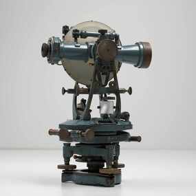
Instrument - Theodolite, Cooke, Troughton & Simms, c 1940
Theodolites are a highly accurate instrument that measures angles between designated visible points in the horizontal and vertical planes. The theodolite has a long history, with the term first found in 1571 in a surveying textbook 'A geometric practice named Pantometria' by Leonard Digges. (source https://en.wikipedia.org/wiki/Theodolite). Cooke Troughton & Simms began when John Troughton starting selling products in Fleet Street, London in 1782. He went into partnership with his brother Edward in 1807 who expanded the business considerably. William Simms, a former apprentice with the company was taken as a partner and then manager after Edward died in 1835 and the company became Troughton & Simms. By 1887 the company was able to produce all the parts necessary for their instruments and the company employed nearly 200 people and was one of the most well respected firms of instrument makers of the 1800's. James Simms, son of William who had inherited the company died in 1915 and the company was turned into a limited liability company by his two sons William and James. Things however were not so easy for the two sons and in 1922 the business was brought out by their rival T. Cooke & Sons becoming Cooke, Troughton & Simms. Theodolites are used by surveyors as part of their everyday work and although there is no specific information regarding the provenance of this particular one it is assumed it was used locally by the City of Bendigo and / or the Lands Department.A grey theodolite no 39161 made by Cooke, Thoughton & Simms. Various moving parts showing signs of extensive use particularly on the uprights on the main body and around knobs and dials where the paint is worn back to brass.Cooke, Thoughton & Simms Ltd / York. England / No 39161. Sticker; DPS - Asset No / (barcode) / 0010173city of greater bendigo administration item, lands and survey department bendigo -
 Glen Eira Historical Society
Album - Album page, Nithsdale now Five Way Hill, Kambrook Road, Circa 1972
This photograph is part of the Caulfield Historical Album 1972. This album was created in approximately 1972 as part of a project by the Caulfield Historical Society to assist in identifying buildings worthy of preservation. The album is related to a Survey the Caulfield Historical Society developed in collaboration with the National Trust of Australia (Victoria) and Caulfield City Council to identify historic buildings within the City of Caulfield that warranted the protection of a National Trust Classification. Principal photographer thought to be Trevor Hart, member of Caulfield Historical Society. Most photographs were taken between 1966-1972 with a small number of photographs being older and from unknown sources. All photographs are black and white except where stated, with 386 photographs over 198 pages. Glen Eira Heritage Management Plan (1996) by Andrew Ward and Associates - Vol 3 "Nithsdale", built for J.S. Crouchin 1858 and extended in 1885 with a tower and associated rooms, survives as testimony to the nineteenth century occupation of the vicinity of the Kambrook/Glen Eira Road intersection. Caulfield's Building Heritage by Dr Geulah Solomon, Vol 1 p49 records it as a small Victorian mansion home on bluestone foundations of Italianate style with a tower. Built for J S Chambers circa 1860, it was built in stages and then the land subdivided in the 1920s. Other owners include Adolph F Brockhoff (of Brockhoff Biscuits company). Names used besides Nithsdale have been Bundoora and Five Way Hill. Page 102 of Photograph Album with four photographs (three landscape and one portrait) of Nithsdale, now known as Five Way Hill. Three views of the tower and one of the house.Handwritten: "Nithsdale" now "Five Way Hill" Kambrook road [top right] / CNR KAMBROOK AND GLENEIRA ROADS [under bottom right photo] / 102 [bottom right]trevor hart, north caulfield, victorian, mid victorian, late victorian, tower, j.s. crouchin, 1850's, 1880's, italianate, rendered, five way hill, nithsdale, slate roof, plaster arches, ornamental columns, triangular pediment, ornamental parapet, cast iron balconies, kambrook road, glen eira road, t crouch, j s crouchin, mansions, j s chambers, bluestone foundations, land subdivision, adolph f brockhoff, bundoora, house names -
 Glen Eira Historical Society
Album - Album page, Grimwade House, Orrong Road, Circa 1972
This photograph is part of the Caulfield Historical Album 1972. This album was created in approximately 1972 as part of a project by the Caulfield Historical Society to assist in identifying buildings worthy of preservation. The album is related to a Survey the Caulfield Historical Society developed in collaboration with the National Trust of Australia (Victoria) and Caulfield City Council to identify historic buildings within the City of Caulfield that warranted the protection of a National Trust Classification. Principal photographer thought to be Trevor Hart, member of Caulfield Historical Society. Most photographs were taken between 1966-1972 with a small number of photographs being older and from unknown sources. All photographs are black and white except where stated, with 386 photographs over 198 pages. From Victorian Heritage Database citation HO54 Grimwade House, former Harleston stables, outbuilding, garden, gate and Picconia excelsa tree. https://vhd.heritagecouncil.vic.gov.au/places/35573 as at (28/10/2020) ''Harleston'', now "Grimwade House", is situated at no. 67 Balaclava Road, Caulfield North, at the Orrong Road corner. It was built for Frederick, later Sir Frederick, Grimwade, to the design of architect Thomas Watts in 1875. Today the complex has been incorporated in the Melbourne Grammar Junior School campus. It retains not only the main house but also the stables and mature garden setting with driveway and gates. It is historically, aesthetically and socially significant.From Victorian Heritage Database citation HO54 Grimwade House, former Harleston stables, outbuilding, garden, gate and Picconia excelsa tree. https://vhd.heritagecouncil.vic.gov.au/places/35573 as at (28/10/2020) It is historically significant (Criterion A) as the former home of prominent business man, speculator and benefactor, Sir Frederick Grimwade. Both Grimwade and his house are exemplars of the commercial enterprise of the Boom period and the amassing of personal fortunes with which it is associated. It is aesthetically significant (Criterion E) as an imposing yet stately large house of its time, the classic Italian form with comer verandah terminated by projecting wings being most distinctively seen in this instance. It is enhanced not only by the garden setting but also by the delicate cast iron verandah spandrels, stained glass work and stencilled ceiling in the music room. It is socially significant (Criterion G) on account of the value placed on it by the community associated with the Melbourne Grammar Junior School since its inception on this site in 1911.Page 154 of Photograph Album with five photographs (4 landscape and one portrait) including Grimwade House, gates and a tram shelter.Handwritten: Grimwade House (Melbourne Grammar Prep School) / incorporating "Harleston" Orrong Rd. S.E cnr Balaclava Rd [top right] / 154 [bottom right]trevor hart, verandah, porch, slate roof, garden, grimwade house, grimwade, harleston, sir frederick grimwade, thomas watts, orrong road, balaclava road, melbourne grammar, melbourne grammar junior school, italianate, cast iron verandah spandrels, stained glass, stencilled ceiling, mgs, m.g.s, school, grimwade family, jessie grimwade, gates, palisade style fence, cast iron spears, stone plinths, melbourne grammar prep school, victorian style, cast iron work, caulfield north, gardens, cars, tram services, outbuildings, stables, trees, picconia excelsa tree