Showing 3211 items
matching road maps
-
 Wodonga & District Historical Society Inc
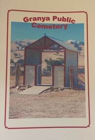
Booklet - Granya Public Cemetery
This booklet was compiled by the Granya Heritage group. It contains records of people buried at the Granya Public Cemetery between 1880 and 2003. The booklet contains maps of the plots in both the Protestant and Catholic sections of the cemetery. Where available information provided includes Surname, Given Name, Year of Death, Age, Parents , Registration No., Denomination and Cause of Death.A booklet containing a plan of the Granya Public Cemetery and a listing of the people buried there between 1880 and 2003. The cover features a colour photograph of the gateway to the cemetery.non-fictionThis booklet was compiled by the Granya Heritage group. It contains records of people buried at the Granya Public Cemetery between 1880 and 2003. The booklet contains maps of the plots in both the Protestant and Catholic sections of the cemetery. Where available information provided includes Surname, Given Name, Year of Death, Age, Parents , Registration No., Denomination and Cause of Death.granya public cemetery, cemetery records -
 Wodonga & District Historical Society Inc
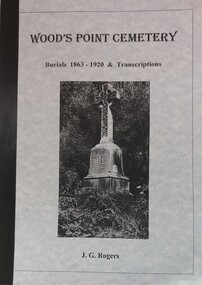
Booklet - Wood's Point Cemetery Records Burials 1863 - 1920 & Transcriptions, Rogers, J. G, 1995
A detailed history of the town of Wood's Point and stories of many of the people buried in the Cemetery. It also contains an analysis of places of origin and a glossary of causes of death. An index and a bibliography are included.A book containing detailed information about the history of Wood's Point, Victoria. It gives detailed information about citizens of Wood's Point buried at the local cemetery. Maps of the area are included.non-fictionA detailed history of the town of Wood's Point and stories of many of the people buried in the Cemetery. It also contains an analysis of places of origin and a glossary of causes of death. An index and a bibliography are included.epitaphs -- victoria -- woods point, cemeteries -- victoria -- woods point, woods point cemetery -
 Wodonga & District Historical Society Inc
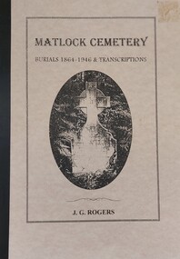
Booklet - Matlock Cemetery Records Burials 1864 - 1946 & Transcriptions, Rogers, J. G, 1999
A detailed history of the town of Matlock and stories of many of the people buried in the town's Cemetery. It also contains an analysis of places of origin and a glossary of causes of death.A book containing information about the history of Matlock, Victoria. Detailed information about citizens of Matlock buried at the local cemetery. Maps of the area are included as well as official government communications related to the establishment of the cemetery. A bibliography and index are also provided.non-fictionA detailed history of the town of Matlock and stories of many of the people buried in the town's Cemetery. It also contains an analysis of places of origin and a glossary of causes of death. matlock cemetery, matlock, small cemeteries victoria -
 Wodonga & District Historical Society Inc
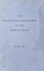
Book - The Resources and Development of the Murray Valley - Volume 1, 1947 - 1952
This report by the Murray Valley Resources Survey Committee is a detailed analysis of Importance and future the Murray River Valley and Basin for the economic development of Australia. It includes a lengthy Foreword written by Prime Minister, Robert Menzies. A map of Australia with the Murray Valley River and Basin shaded in green, and a fold-out detailed map of the Murray River are featured.A small publication in a bound blue cover with black text. This report by the Murray Valley Resources Survey Committee is a detailed analysis of Importance and future the Murray River Valley and Basin for the economic development of Australia. It includes a lengthy Foreword written by Prime Minister, Robert Menzies. A map of Australia with the Murray Valley River and Basin shaded in green, and a fold-out detailed map of the Murray River are featured.murray river development, murray basin, murray river resources -
 Wodonga & District Historical Society Inc
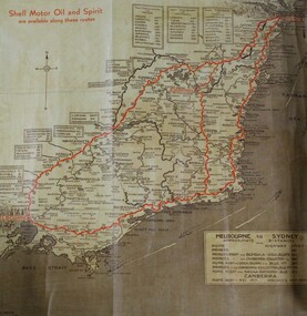
Map - Hamilton-Smith Collection Highway Map c. mid 1900s
... A brown and tan highway map with red road markings showing... driving drive car road A brown and tan highway map with red road ...The Hamilton-Smith collection was donated by the children of Grace Mary Hamilton-Smith nee Ellwood (1911-2004) and William John (Jack) Hamilton-Smith (1909-1984) who settled in Wodonga in the 1940s. The Ellwood family had lived in north-east Victoria since the late 1800s. Grace’s mother, Rosina Ellwood nee Smale, was the first teacher at Baranduda in 1888, and a foundation member of the C.W.A. Rosina and her husband Mark retired to Wodonga in 1934. Grace and John married at St. David’s Church, Albury in 1941. John was a grazier, and actively involved in Agricultural Societies. The collection contains significant items which reflect the local history of Wodonga, including handmade needlework, books, photographs, a wedding dress, maps, and material relating to the world wars.This item has well documented provenance and a known owner. It forms part of a significant and representative historical collection which reflects the local history of Wodonga. It contributes to our understanding of social life in mid-twentieth century Wodonga, as well as providing interpretative capacity for themes including local history and social history.A brown and tan highway map with red road markings showing the south east of Australia from Melbourne to Sydney map, highway, wodonga, melbourne, sydney, travel, hamilton-smith, hamilton-smith collection, driving, drive, car, road -
 Wodonga & District Historical Society Inc
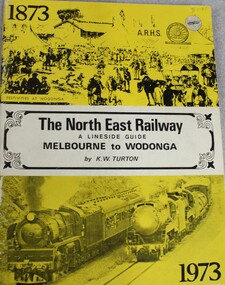
Book - The NORTH EAST RAILWAY Melbourne to Wodonga- A Lineside Guide, Keith W. Turton, 1973
A detailed history and description of the North East Rail Line, including information about each station and siding and relevant maps.non-fictionA detailed history and description of the North East Rail Line, including information about each station and siding and relevant maps.railway transport victoria, north east railway victoria, victoria railways, lineside rail guide -
 Wodonga & District Historical Society Inc
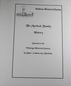
Book - The Mortlock Family History 1833-2003, R. Polkinghorne & R Mortlock
A detailed history of the Mortlock family, from their convict and then successful settler ancestor, Thomas John Mortlock, through succeeding generations of high-country settlers. Later branches of the family settled in the Castlemaine area, Wagga Wagga and Bethanga near Wodonga, Victoria. The history is profusely illustrated with maps, family photographs provided by Maud Cadman. There is some detail of the methods of settling the high country of the Monaro before the new Land Acts of 1861 and anecdotal reference to one family member running the Post Office at the Prisoner of War Camp at Cowra during World War IInon-fictionA detailed history of the Mortlock family, from their convict and then successful settler ancestor, Thomas John Mortlock, through succeeding generations of high-country settlers. Later branches of the family settled in the Castlemaine area, Wagga Wagga and Bethanga near Wodonga, Victoria. The history is profusely illustrated with maps, family photographs provided by Maud Cadman. There is some detail of the methods of settling the high country of the Monaro before the new Land Acts of 1861 and anecdotal reference to one family member running the Post Office at the Prisoner of War Camp at Cowra during World War IImortlock family, high country, bethanga, thomas mortlock, monaro -
 City of Kingston
Map - Parish of Moorabbin
Warning: This object includes historical language referring to First Nations Peoples which is no longer appropriate but has been recorded for historical purposes. Produced in 1853, this map shows the land holdings of European families. While the majority of holdings are small there are also large land holdings as can be seen with Henry Dendy's Special Survey. Of particular note is the "Reserve for Aborigines" which was established in approximately 1841 and consisted of over 830 acres. This area is the current location of Mordialloc township and Attenborough Park, in Mordialloc, is the last remnant of the reserve. An Alfred Sikes, possibly the surveyor/cartographer who drew this parish plan, purchased land in Berwick in 1854.A handrawn map on fabric, with blue markings representing the coastline to Port Phillip Bay, red markings representing a proposed train line to Mordialloc, major roads and street, as well as a "Reserve for Aborigines", which constituted approximately 830 acres. In the bottom right hand corner, the map has been signed and dated.Handwritten in ink: Alfred Sikes / 38 Collins St East / June. 1853moorabbin, mordialloc, dendy, port phillip bay, aboriginal reserve, attenborough park -
 City of Kingston
Pamphlet - Black and white, Robert McCamish & John Gilpin (Vendors), For Private Sale Station Entrance Estate, Highett, 1930s
Sales plan for land in the suburb of Highett, bounded by Wickham Road, Railway Parade, Highett Road and Point Nepean Street. The developing urban area of Highett within the City of Kingston. This land sale pamphlet illustrates the subdivision of land within the municipality and the changing demographic of the district as new houses are constructed. The extension of the railway line from the city to Mordialloc opened up the land for development.Black and white pamphlet advertising for private sale the Station Entrance Estate, Highett. Incorporates a map of the estate bordered by Wickham Road, Railway Parade, Highett Road and Point Nepean Road. Handwritten in black ink on reverse: Station Entrance / Estate / Late [indecipherable]highett, land sales, estate -
 City of Kingston
Pamphlet - Colour, Stillwell and Co, The Hill Estate Highett Great Subdivisional Auction Sale, 1917
Sales plan for land in the suburb of Highett, bounded by Point Nepean Road and incorporating Sandford Street, Turner Road, Alfred Street, Peace Street and Tennyson Street. .The developing urban area of Highett within the City of Kingston. This land sale pamphlet illustrates the subdivision of land within the municipality and the changing demographic of the district as new houses are constructed.Colour pamphlet advertising subdivisional auction sale of the Hill Estate Highett. Incorporates a map of the estate bordered by Point Nepean Road and encompassing Sandford Street, Turner Road, Alfred Street, Peace Street and Tennyson St. Handwritten in grey pencil on reverse: Hill Street / Jamieson Handwritten in blue pencil on reverse: The Hill Estate Handwritten in blue pencil on subdivision map: [tick] [on majority of properties marked on map]highett, land sales, estate -
 City of Kingston
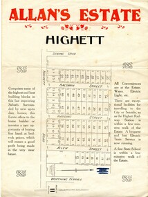
Pamphlet - Colour, Allan's Estate Highett, 1930s
Sales plan for land in the suburb of Highett, bounded by Spring Road, Highett Road and Worthing Terrace.The developing urban area of Highett within the City of Kingston. This land sale pamphlet illustrates the subdivision of land within the municipality and the changing demographic of the district as new houses are constructed.Colour pamphlet advertising Allan's Estate, Highett. Incorporates a map of the estate bordered by Spring Road, Highett Road and Worthing Terrace.Handwritten in grey pencil on reverse: Allan's Estate / Highett Crossed out in blue pencil on front: Name and address of what appears to be a solicitorhighett, land sales, estate -
 City of Kingston
Pamphlet - Colour, R. Malcolm Estate Agents et al, Last Chance Land Sale Heritage Estate Cheltenham, c.1994
Sales plan for land in the suburb of Cheltenham, bounded by Chesterville Road and Bernard Street, and incorporating Clendon Court, Tintern Grove and Tintern MewsThis land sale pamphlet illustrates one of the last subdivisions of the century in Cheltenham, incorporating house and land packages. It shows that land sales and subdivision for the area had slowed considerably by the end of the 1900s and that the infrastructure was significantly developed. Colour pamphlet advertising last chance land sale of Heritage Estate Cheltenham. Incorporates a map of the estate bordered by Chesterville Road and Bernard Street, and including Clenton Court, Tintern Grove and Tintern Mews.cheltenham, land sales, estate -
 City of Kingston
Pamphlet - Colour, W. H. Wood Estate Agent, Subdivisional Land Auction Barker's Estate Cheltenham, 1919
Sales plan for land in the suburb of Cheltenham, along Barker StreetThe developing urban area of Cheltenham within the City of Kingston. This land sale pamphlet illustrates the subdivision of land within the municipality and the changing demographic of the district as new houses are constructed.Colour pamphlet advertising subdivisional land auction of Barker's estate, on Barker Street Cheltenham.Handwritten in grey pencil on the subdivision map: a series of numbers on each block possibly indicating the sale price. Handwritten in grey pencil on the subdivision map: Roy- joined to subdivision 6 Handwritten in grey pencil on the subdivision map: x on the border between subdivision 17 and 16, and again on the border between subdivision 12 and 11.cheltenham, land sales, estate -
 City of Kingston
Pamphlet - Black and white, Stott & Burke, Highland Estate Bentleigh, c.1915
Sales plan for land in the suburb of Bentleigh, along Collins and Ross Streets, bounded by Jasper Road.The developing urban area of Bentleigh within the City of Kingston. This land sale pamphlet illustrates the subdivision of land within the municipality and the changing demographic of the district as new houses are constructed.Black and white pamphlet advertising for private sale the Highland Estate, Bentleigh. Incorporates a map of the estate between Collins St and Ross St, bordered by Japser Road. Handwritten in grey pencil on map: additional subdivisions numbered 15-19 drawn along Ross St Handwritten in grey pencil on map: indecipherable annotations to subdivisions 1, 3 and 14land sales, bentleigh, estate -
 City of Kingston
Pamphlet - Colour, Ozone Hill Estate, Cheltenham, 1923
Sales plan for land in the suburb of Cheltenham, along both sides of Victori Avenue, off Weatherall Road.The developing urban area of Cheltenham within the City of Kingston. This land sale pamphlet illustrates the subdivision of land within the municipality and the changing demographic of the district as new houses are constructed.Colour pamphlet advertising for sale the Ozone Hill Estate, Cheltenham. Incorporates a map of the estate on either side of Victor Avenue, off Weatherall Road. Handwritten in blue ink on the subdivision map: 'Sold' is written on subdivisions 1-4, 8, 11, 13, 16-26, 28, 29, 33, 39-41 Handwritten in blue ink on the subdivision map: 'House being erected' is written on subdivisions 22 and 33. Handwrittten in grey pencil adjacent to subdivisions 21 and 22: Tennis / Courts / being / constructed / here Handwritten in grey pencil at bottom of page: Revised to 30/1/24 Handwritten in grey pencil on subdivision map: assumed land sale price is recorded on subdivisions 5-9, 9-10, 12, 14-15, 27, 30-32, 34-38. land sales, cheltenham, estate -
 City of Kingston
Pamphlet - Colour, H. R. Hill & Co, Walker's Estate, Cheltenham for sale by public auction, c. 1923
Sales plan for land in the suburb of Cheltenham, encompassing both sides of Walker Grove, a section of Centre Dandenong Rd and Axelton St. The developing urban area of Cheltenham within the City of Kingston. This land sale pamphlet illustrates the subdivision of land within the municipality and the changing demographic of the district as new houses are constructed.Black and white pamphlet advertising for private sale the Station Entrance Estate, Highett. Incorporates a map of the estate bordered by Wickham Road, Railway Parade, Highett Road and Point Nepean Road.Handwritten in black pen on subdivision map: 'x' written on subdivisions 2, 3, 8-11, 15-17, 19. Potentially indicating that these properties did not sell at auction. Handwritten in black pen on subdivision map: assumed sale price on subdivisions 1, 4-7, 12-14, 18, 20-31. land sales, cheltenham, estate -
 City of Kingston
Pamphlet - Colour, Stillwell and Co, Cheltenham Charman Estate Realising Auction, 1921
Sales plan for land in the suburb of Cheltenham, along Charman Road and Weatherall Street.The developing urban area of Cheltenham within the City of Kingston. This land sale pamphlet illustrates the subdivision of land within the municipality and the changing demographic of the district as new houses are constructed.Colour pamphlet advertising realising auction of the Charman Estate, Cheltenham. Incorporates a map of the estate, showing subdivisions along Charman Road and Weatherall Street.land sales, cheltenham, estate -
 City of Kingston
Pamphlet - Colour, Duffus Bros, Railway Reserve Highett, c. 1923
Sales plan for land in the suburb of Highett, titled Railway Reserve, incorporating properties along Wolseley Street, Livingston Street, Highett Road and Worthing Road. The developing urban area of Highett within the City of Kingston. This land sale pamphlet illustrates the subdivision of land within the municipality and the changing demographic of the district as new houses and shops are constructed close to infrastructure.Colour pamphlet advertising thirty eight shop and villa sites for sale at the Railway Reserve, Highett. Incorporates a map of the reserve with properties available on Wolseley Street, Livingston Street, Highett Road and Worthing Road. Handwritten in grey pencil: assumed sale price recorded on subdivisions 1-7, 10, 22, 23 and 34 Handwritten in grey pencil on subdivision 4: C. Nevill / City of Melbourne bank Handwritten in grey pencil across subdivision 7: 49' Handwritten in grey pencil across subdivision 21 and 22: 134' Handwritten in grey pencil across subdivision 25 and 26: 200' Handwritten in grey pencil across subdivision 36 and 37 and both top and bottom: 120' Hand drawn in blue pencil: outline of subdivision 4 Hand drawn in blue pencil: outline of subdivisions 7, 23, 28, 37, 38 along left hand side, subdivisions 38, 37 and 36 on Wolseley Street, subdivisions 30 and 29 along Wolseley Street, subdivisions 29 and 24 along the middle of the plan, subdivisions 24 and half of 25 along Livingston Street, half of subdivision 20 along the middle of the plan, subdivisions 21 and 22 along the Right of Way between Livingston Street and Highett Road, and along the right hand border of subdivision 7. Handwritten in ink adjacent to the subdivision plan, updside down, in the bottom right hand corner: 276 / 54 / 280 / 45 / 320 / 202 / 200 / 134 / horizontal line / 11/14 Handwritten in ink adjacent to the subdivision plan, updside down, in the bottom right hand corner: 1714)2200(15 / 1714 / horizontal line / 486land sales, highett -
 City of Kingston
Pamphlet - Colour, Roy Dunn Pty. Ltd, Central Corner Estate Moorabbin and Highett, c. 1923
Sales plan for land in the suburbs of Highett and Moorabbin, bordered by Point Nepean Road and Wickham Road East incorporating William StreetThe developing urban area of Highett and Moorabbin within the City of Kingston. This land sale pamphlet illustrates the subdivision of land within the municipality and the changing demographic of the district as new houses are constructed close to infrastructure.Colour pamphlet advertising for private sale land in the Central Corner Estate in Moorabbin and Highett. Incorporates a map of the estate bordered by Point Nepean Road and Wickham Road East, with subdivisions also available on both sides of William Street. Handwritten in blue pencil on subdivision plan: a tick is drawn on subdivisions 2-18 Handwritten in blue pencil on subdivision 6: a box with an x inside Handwritten in blue pencil on subdivisions 10 and 12: S Handwritten in black ink on front page: [indecipherable] / McKittricks Handwritten in grey pencil on rear page: McKilhick / Nepean Rd Handwritten in grey pencil on rear page upside down: 160000 / 15 8300 [crossed out] land sales, estate, highett, moorabbin -
 City of Kingston
Pamphlet - Colour, Roy Dunn Pty. Ltd, Subdivisional auction of Highett Station Estate, c.1924
Sales plan for land in the suburb of Highett, bounded by Worthing Road, and the Melbourne to Frankston Electric Railway Line, including LePage Street. The developing urban area of Highett within the City of Kingston. This land sale pamphlet illustrates the subdivision of land within the municipality and the changing demographic of the district as new houses are constructed close to infrastructure.Colour pamphlet advertising a subdivisional auction of the Highett Station Estate. Incorporates a map of the estate bordered by Worthing Road and the Melbourne to Frankston Electric Railway, and including LePage Street. Handwritten in black ink on front cover: Late LePage / Wickham Rdland sales, estate, highett -
 City of Kingston
Pamphlet - Colour, W. H. Wood Estate Agent, Realising sub-divisional auction sale Bentleigh Park Estate, Bentleigh, 1920
Sales plan for land in the suburb of Bentleigh, bounded by Centre Road, and incorporating subdivisions on either side of Elizabeth Street (Wheatley Road), Oak Street and Beech Street.The developing urban area of Bentleigh within the City of Kingston. This land sale pamphlet illustrates the subdivision of land within the municipality and the changing demographic of the district as new houses are constructed close to infrastructure.Colour pamphlet advertising a realising sub-divisional auction sale of the Bentleigh Park Estate, Bentleigh. Incorporates a map of the estate bordered by Centre Road, and including Elizabeth Street (Wheatley Road), Oak Street and Beech Street.Hand drawn in grey pencil: a small square on subdivision 33 Hand drawn in grey pencil: a small square incorporating a cross on subdivision 24 Hand written in black ink on reverse: Bentleigh Park / Estate / Ward late Andersonsland sales, estate, bentleigh -
 City of Kingston
Pamphlet - Colour, T. H. Ould Publishing Co, The Ridge Estate, Cheltenham, c. 1930
Sales plan for land in the suburb of Cheltenham, bounded by Johnston Street, Silver Street and Cavanagh Street, incorporating lots on either side of Sunray Avenue.The developing urban area of Cheltenham within the City of Kingston. This land sale pamphlet illustrates the subdivision of land within the municipality and the changing demographic of the district as new houses are constructed close to infrastructure.Colour pamphlet advertising for sale lots in The Ridge Entrance Estate, Cheltenham. Incorporates a map of the estate bordered by Johnston Street, Silver Street and Cavanagh Street, including subdivision lots on either side of Sunray Avenueland sales, estate, cheltenham -
 City of Kingston
Pamphlet - Colour, S. M. Reynolds, Estate Agent, Moorabbin Shire Hall Estate Second Section, c. 1930
Sales plan for land in the suburb of Moorabbin, bounded by South Road and Highbury Street, including Prince Street, Charming Street, Thomas Avenue and Keith Road.The developing urban area of Moorabbin within the City of Kingston. This land sale pamphlet illustrates the subdivision of land within the municipality and the changing demographic of the district as new houses are constructed close to infrastructure.Colour pamphlet advertising for private sale the Moorabbin Shire Hall Estate, Moorabbin. Incorporates a map of the estate bordered by South Road and Highbury Street, including Prince Street, Charming Street, Keith Road and Thomas Avenue.Handwritten in grey pencil on subdivision map below subdivision 63: £4 Handwritten in grey pencil on subdivision map below subdivision 66: 4 Handwritten in grey pencil on subdivision map below subdivision 80: 3. Handwritten in grey pencil on subdivision map below subdivision 81: 4 Handwritten in grey pencil on subdivision map below subdivision 83: 2 Handwritten in grey pencil on subdivision map below subdivision 96: £3 Handwritten in grey pencil on subdivision map below subdivision 97: 3 Handwritten in grey pencil on subdivision map to the left of subdivision 102: 3 Handwritten in grey pencil on subdivision map on the corner of Thomas Avenue and Highbury Street: vertical line next to a square with a cross in it.land sales, estate, moorabbin -
 City of Kingston
Pamphlet - Colour, Fergusson & Mitchell Lith, Sandringham Rises, c. 1888
Sales plan for land in the suburb of Sandringham, bounded by Bluff Road, Bay Road and William Street, and incorporating Frances Street.The developing urban area of Highett (then called Sandringham) within the City of Kingston. This land sale pamphlet illustrates the subdivision of land within the municipality and the changing demographic of the district as new houses are constructed close to infrastructure.Colour pamphlet advertising for sale 35 lots in Sandringham Rises, Sandringham. Incorporates a map of the estate bordered by Bluff Road, Bay Road and William Street, including Frances Street.Handwritten in grey pencil next to the words 'THREE O'CLOCK': 1888 Handwritten in blue ben next to the words '& BUSINESS SITES': 1888land sales, sandringham, highett -
 City of Kingston
Pamphlet - Colour, Brock Bros, South Brighton Township Estate, 1888
Sales plan for land in the suburb of South Brighton (Moorabbin), bounded by Point Nepean Road, South Road, Patterson Street and the Mordialloc Railway Line. Incorporates Wolsely Street and Gordon StreetThe developing urban area of Moorabbin within the City of Kingston. This land sale pamphlet illustrates the subdivision of land within the municipality and the changing demographic of the district as new houses are constructed close to infrastructure.Colour pamphlet advertising for private sale the South Brighton Township Estate, South Brighton. Incorporates a map of the estate bordered by Point Nepean Road, South Road, Patterson Street, and the Mordialloc Railway Line. Includes Wolsley Street and Gordon Street. land sales, south brighton, estate, moorabbin -
 City of Kingston
Pamphlet - Colour, Stillwell and Co, The Hill Estate, Highett, 1917
Sales plan for land in the suburb of Highett, bounded by Point Nepean Road and including Sandford Street, Turner Road, Alfred Street and Peace Street.The developing urban area of Highett within the City of Kingston. This land sale pamphlet illustrates the subdivision of land within the municipality and the changing demographic of the district as new houses are constructed close to infrastructure.Colour pamphlet advertising for sale at auction The Hill Estate, Highett. Incorporates a map of the estate bordered by Point Nepean Road and including Sandford Street, Turner Road, Alfred Street and Peace Street.Handwritten in grey pencil on subdivision map next to subdivisions 91, 92, 93, 106, 107 and 108: x Handwritten in grey pencil on back cover: The / Hill Estate / Highettland sales, estate, highett -
 City of Kingston
Pamphlet - Black and white, J. F. Brady, The Hill Estate, Highett, c. 1905
Sales plan for land in the suburb of Highett, bounded by Sandford Street, Turner Street and Point Nepean RoadThe developing urban area of Highett within the City of Kingston. This land sale pamphlet illustrates the subdivision of land within the municipality and the changing demographic of the district as new houses are constructed close to infrastructure.Black and white pamphlet advertising for sale the Hill Estate, Highett. Incorporates a map of the estate bordered by Sandford Street, Turner Street and Point Nepean Road.Handwritten in grey pencil on reverse: The Hillland sales, highett, estate -
 City of Kingston
Pamphlet - Colour, Highett Town, 1888
Sales plan for land in the suburb of Highett, bounded by Highett Road, Worthing Terrace and the railway line, and incorporating Major Street and Train Street.The developing urban area of Highett within the City of Kingston. This land sale pamphlet illustrates the subdivision of land within the municipality and the changing demographic of the district as new houses are constructed close to infrastructure.Colour pamphlet advertising for private sale the Station Entrance Estate, Highett. Incorporates a map of the estate bordered by Wickham Road, Railway Parade, Highett Road and Point Nepean Road.land sales, highett -
 City of Kingston
Pamphlet - Colour, J. F. Brady, Matthiesson's Estate, Highett, c. 1905
Sales plan for land in the suburb of Highett, bounded by Tennyson Street, James Street and Point Nepean Road and including Maher Street, Connors Street, Enright Street, Edward Street, James Street and Matthieson Street.The developing urban area of Highett within the City of Kingston. This land sale pamphlet illustrates the subdivision of land within the municipality and the changing demographic of the district as new houses are constructed close to infrastructure.Colour pamphlet advertising for private sale subdivisions in the Matthiesson's Estate, Highett. Incorporates a map of the estate bordered by Tennyson Street, James Street and Point Nepean Road and including Maher Street, Connors Street, Enright Street, Edward Street, James Street and Matthieson Street.Handwritten in blue pencil: x marked on every subdivision on the map Handwritten in grey pencil at the end of the Price List: x not sold Handwritten in grey pencil adjacent to subdivisions 58, 167 and 166: JP. Turner Handwritten in grey pencil adjacent to subdivision 164: [indecipherable] Markings in grey pencil around the edges of the subdivision map Handwritten in grey pencil on reverse: Matthiesson / Matthiesson Estate / Matthiesson Estateland sales, estate, highett -
 City of Kingston
Pamphlet - Colour, Smith, Nicolson Pty. Ltd, Cheltenham Estate, c. 1890
Sales plan for land in the suburb of Cheltenham, bounded by Point Nepean Road and Swinden Avenue, including Evesham Road and Wallingford Street.The developing urban area of Cheltenham within the City of Kingston. This land sale pamphlet illustrates the subdivision of land within the municipality and the changing demographic of the district as new houses are constructed close to infrastructure.Colour pamphlet advertising for private sale Cheltenham Estate. Incorporates a map of the estate bordered by Point Nepean Road and Swinden Avenue, including Evesham Road, and Wallingford Street.Handwritten in red ink on subdivison 45: D / H Handwritten in red ink on subdivision 46: Anderson Handwritten in red ink on subdivisions 88, 87, 77 and 56: K / D Handwritten in red ink on subdivision 86: D / H Handwritten in red ink on subdivision 63 and 62: Hudson Handwritten in red ink on subdivision 59 [indecipherable] Handwritten in red ink on subdivision 58: aB Handwritten in red ink on subdivision 57: Lavosh Handwritten in grey pencil on subdivision 28, 26, 24, 67, 58, 49: B Handwritten in grey pencil on subdivisions 78 and 79: Paint Handwritten in purple pencil on subdivsion 114 and 86: B land sales, estate, cheltenham