Showing 723 items
matching aerial photos
-
 Eltham District Historical Society Inc
Photograph - Aerial Photograph, Landata, Eltham, Vic, Apr. 1972
... Aerial Photo... Source: Landata.vic.gov.au Aerial Photo Details: Project No :985... Source: Landata.vic.gov.au Aerial Photo Details: Project No :985 ...Centred on present day Diamond Creek Trail at the Eltham Leisure Centre bounded by Central Park to north, Main Road at Falkiner Street to south, MacMahon Ball Paddock to east and Grand Boulevard at Buena Vista Drive to west. Historic Aerial Imagery Source: Landata.vic.gov.au Aerial Photo Details: Project No :985 Project : MELBOURNE 1972 Run : 28 Frame : 207 Date : 04/1972 Film Type : B/W Camera : RC10 Flying Height : 5700 Scale : 9600 Film Number : 2635 GDA2020 : 37°43'25"S, 145°08'20"E MGA2020 : 335985, 5823223 (55) Melways : 21 G7 (ed. 42)aerial photo, neil webster collection, 1972-04, eltham, buena vista drive, central park, diamond creek trail, eltham leisure centre, falkiner street, grand boulevard, macmahon ball paddock, main road, melway 21g7 -
 Eltham District Historical Society Inc
Photograph - Aerial Photograph, Landata, Eltham, Main Road; Mt Pleasant Rd to Railway Rd, Dec. 1945
... Aerial Photo...: Landata.vic.gov.au Aerial Photo Details: Project No :65 Project : MELBOURNE...: Landata.vic.gov.au Aerial Photo Details: Project No :65 Project : MELBOURNE ...Centred on Main Rd and Henry St, Eltham bounded by Railway Road to north, Mount Pleasant Road at Main Road to south, top of the hill in Arthur Street to east and Karingal Drive at Sherbourne Road to west. Historic Aerial Imagery Source: Landata.vic.gov.au Aerial Photo Details: Project No :65 Project : MELBOURNE AND METROPOLITAN PROJECT NO. 2 Run : 8 Frame : 70 Date : 01/1951 Film Type : B/W Camera : EAG9 Flying Height : 12200 Scale : 12000 Film Number : 1419 GDA2020 : 37°43'06"S, 145°08'45"E MGA2020 : 336589, 5823811 (55) Melways : 21 J6 (ed. 42)aerial photo, eltham, main road, henry street, arthur street, bolton street, eltham-yarra glen road, neil webster collection, 1951-01, dave lyon house, ernie andrew house, karingal road, melway 21j6, mount pleasant road, railway road -
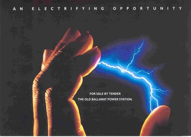 Ballarat Tramway Museum
Pamphlet, Jones Lang Wootton and Jens Gaunt, "An Electrifying Opportunity", Apr. 1993
... Wootton. Has on the rear of the brochure an aerial photo. showing... on the rear of the brochure an aerial photo. showing the location ...Real Estate advertising, marketing brochure or pamphlet, 240g stock, four colour, laminated after printing for the sale by tender of the former SEC Ballarat A power station, corner Ripon and Wendouree Parade, Ballarat. Agents Jens Gaunt, and Jones Lang Wootton. Has on the rear of the brochure an aerial photo. showing the location, location map and a short marketing statement. Three copies held. Two additional copies added 19/05/2006. See Reg Item 2783 for the contract of sale document.trams, tramways, power station, wendouree parade, sec, ballarat a power station -
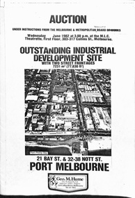 Melbourne Tram Museum
Pamphlet, Geo M Hume, "Auction - Outstanding Industrial development site - Port Melbourne", May. 1982
... an aerial photo of the site, photos of the buildings, addresses... to the owners name from the MMBW to the MMTB. Includes an aerial ...Draft of a pamphlet - folded A3 sheet for the sale in June 1982 of the former Port Melbourne Bus Depot, near the corner of Bay St and Beach St. Consists of two sheets of 150gsm ? paper bound together with an adhesive tape. A loose sheet showing the layout of the various titles included as well. Note the correction to the owners name from the MMBW to the MMTB. Includes an aerial photo of the site, photos of the buildings, addresses of the block, a site plan, title particular, terms of sale and the Vendors Agent, Geo M Hume.trams, tramways, mmtb, buses, sale of land, port melbourne depot -
 Eltham District Historical Society Inc
Photograph - Aerial Photograph, Landata, Eltham, Feb. 1956
... Aerial Photo... Aerial Imagery Source: Landata.vic.gov.au Aerial Photo Details... Aerial Imagery Source: Landata.vic.gov.au Aerial Photo Details ...Centred on present day Culla Hill and Petty's Orchard, Eltham bounded by Brougham Street and Mount Pleasant Road to north, Monckton Road, Templestowe to south, Reynolds Road to east and Eltham Lower Park and Hohnes Road to west. Historic Aerial Imagery Source: Landata.vic.gov.au Aerial Photo Details: Project No :250 Project : MELBOURNE OUTER SUBURBS PROJECT Run : 18 Frame : 92 Date : 02/1956 Film Type : B/W Camera : EAG9 Flying Height : 10000 Scale : 12000 Film Number : 1176 GDA2020 : 37°43'35"S, 145°09'31"E MGA2020 : 337735, 5822959 (55) Melways : 22 B8 (ed. 42)aerial photo, 1956-02, neil webster collection, eltham, brougham steet, culla hill, eltham lower park, hohnes road, melway 22b8, monckton road, mount pleasant road, petty's orchard, reynolds road, sweeneys lane, templestowe, yarra river -
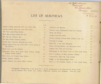 Bendigo Historical Society Inc.
Book - BASIL WATSON COLLECTION: THE FIRST AEROPLANE VOYAGE FROM ENGLAND TO AUSTRALIA, 1920
... Smith (no flight photos). NSW Edition with aerial photos... Smith (no flight photos). NSW Edition with aerial photos ...32 page booklet ''The first aeroplane voyage from England to Australia'' by Sir Ross Smith KBE, MC, DFC, AFC with 27 aeroviews by Capt. Frank Hurley. Four page description of the flight by Ross Smith (no flight photos). NSW Edition with aerial photos of Sydney, suburbs and country towns. Inscribed on front cover (handwritten) ''Left England November 12th 1919; Arrived Australia December 9th 1919''. Also, stamp of ''R Keith Munro'' and inside cover: address of ''Inveresk'', 126 Forest Street, Bendigo, Victoria, Australia 16-4-20''Sir Ross Smith, K.B.E, A.F.C,D.F.C, M.C.event, official -
 Eltham District Historical Society Inc
Document - Series Listing, Fraser Faithfull et al, Series 33: Shire Aerial Photograph Collection, 2000
... Series consists of 39 aerial photographs and photo maps... melbourne Series consists of 39 aerial photographs and photo maps ...Series consists of 39 aerial photographs and photo maps of the Shire and environs. A separate Item List exists (created on MS Excel spreadsheet), please refer to the attached pagesshire of eltham archives, series listing -
 Glenelg Shire Council Cultural Collection
Photograph - Photograph - Portland Harbour, n.d
... Aerial black and white photo of Portland Harbour showing... Commissioners - Purple stamp. Aerial black and white photo of Portland ...Port of Portland AuthorityBack: 17/77 No.3 - red biro. Portland Harbour Trust Commissioners - Purple stamp.port of portland archives, aerial photography, portland harbour -
Glenelg Shire Council Cultural Collection
Photograph - Photograph - Portland Harbour, n.d
... Aerial black and white photo of Portland Harbour showing... Harbour Aerial black and white photo of Portland Harbour showing ...Port of Portland Authorityport of portland archives, aerial photography, portland harbour -
Glenelg Shire Council Cultural Collection
Photograph - Photograph - aerial view of Portland, n.d
... Aerial black and white photo of Portland Harbour showing... Harbour Back: harb027 - pencil Aerial black and white photo ...Port of Portland AuthorityBack: harb027 - pencilport of portland archives, aerial photography, portland harbour -
Stawell Historical Society Inc
Book - Report, Grampians National Park Draft Management Plan, 1985
... Soft Cover with B/W Photo of aerial view of ranges... Barry Clugston Soft Cover with B/W Photo of aerial view ...For Public comment to National Park Service, Victoria. A Division of the department of Conservation, Forest and LandsSoft Cover with B/W Photo of aerial view of ranges of Grampians. Black taped Spine binding.$5 Barry Clugston -
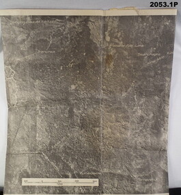 Bendigo Military Museum
photograph - PHOTOGRAPHS WW2, 2053) 24/10/1943; 2053.1) 17/09/1944
... 2053.1) Photo's "Aerial", Binder form, 4 pages, paper... 2053.1) Photo's "Aerial", Binder form, 4 pages, paper yellowed ...2053.1) Photo's "Aerial", Binder form, 4 pages, paper yellowed, photo's written on, area description under each one. B&W. 2053.2) Photo, large Aerial, B&W, "Vunakanau Plantation". Photo written on showing military positions, scale. Mosaic, Toma to Dieldimans Corner (Vunakanau) 17 Sep 1944.photography-photographs, military history - airforce, aerial -
Glenelg Shire Council Cultural Collection
Photograph - Photograph - Portland and the harbour, n.d
... Aerial black and white photo of Portland and the harbour... tanks Aerial black and white photo of Portland and the harbour ...Port of Portland Authorityport of portland archives, portland harbour, fuel storage tanks -
Port Melbourne Historical & Preservation Society
Photograph - J Kitchen & Sons site, Port Melbourne, 1978
... Large black and white aerial photo in narrow gold-coloured... and white aerial photo in narrow gold-coloured metal frame of J ...Large black and white aerial photo in narrow gold-coloured metal frame of J Kitchen & Sons Pty Ltd factory . Port Melbourne Football/Cricket ground top left of photo . Photo taken approx 1978 or later, dated due to types of cars and by comparison with buildings along Boundary St opposite as shown in photos of catalogue iten 3202. Dated also by Glen Cosham who was a Councillor when Woodruff St was sealed and this did not occur until after Oct 1977, probably early 1978. It was paid for by the Country Roads Board as part of the preparations for the opening of the West Gate Bridge and the Johnson St Bridge later that year.industry - manufacturing, built environment - industrial, j kitchen & sons pty ltd, pental products pty ltd, symex, north port oval -
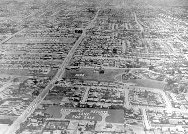 Surrey Hills Historical Society Collection
Photograph - Aerial view Riversdale Heights Estate area, c1923
... aerial photo...A black and white reproduction of an aerial photo... park canterbury primary school aerial photo Beneath ...This was probably part of a real estate promotion for the sale of the Riversdale Heights Estate. This was subdivided by Messrs. Duncan and Weller. Of the allotments offered, 30 were sold and realised £4600. Date of this sale was c December 1923. This suggests that the date This are was one of the last pieces of former rural land to be sub-divided for housing in Surrey Hills.The land between it and South Surrey Park was sub-divided post WW1, hence the naming of the streets after sites of WW1 battles.A black and white reproduction of an aerial photo of the area near the corner of Warragul and Riversdale Roads looking west towards the city. Some features have been identified by name including the Riversdale Heights Estate, which was being sub-divided. North and South Courts are shown. Other roads (unmarked) in the foreground are Graham Street, Allie Street, Thistle Street, Lille Street, Amiens Street, and Marne Street. Beyond these is the area marked 'PARK' (South Surrey Park), which is devoid of vegetation. Areas of Camberwell and Canterbury are also shown. The area covered extends to beyond St Dominic's Church. The original is mounted on a cream deckle-edged paper.Beneath the original on the mount: "SOUTH SURREY HILLS LOOKING WEST c. 1936" [The reference to the sale in the Box Hill Reporter of December 1923 found on Trove suggests that this date is not accurate.] Rear top LH corner of original in Jocelyn Hall's handwriting: "For Centre / from Mr James Long"riversdale heights estate, riversdale road, allie street, south surrey park, lille street, thistle street, amiens street, marne street, south court, north court, duncan and weller, real estate sales, graham street, st dominics church, highfield park, canterbury primary school, aerial photo -
Port Melbourne Historical & Preservation Society
Document - Chemicals for Industry, J Kitchen & Sons, 1960s
... "the Kitchen Story" includes an aerial view photo with names of all... section called "the Kitchen Story" includes an aerial view photo ...Kitchens. Blue covered ringbinder labelled "Chemicals for Industry". General information and sections on each product. Data sheets in each section give details of chemical makeup of each product and suggested applications. Early section called "the Kitchen Story" includes an aerial view photo with names of all buildings.industry, manufacturing, built environment - industrial, j kitchen & sons pty ltd, f g pott - managing director, unichema -
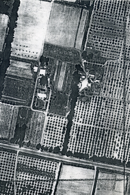 Whitehorse Historical Society Inc.
Photograph, Aerial View of Matheson Orchard, 1944
... Poor photo copy of black and white photo of Aerial View... copy of black and white photo of Aerial View of Matheson ...Poor photo copy of black and white photo of Aerial View of Matheson Orchard 'Strathdon', Springvale Road , Forest Hill.matheson, strathdon orchard, orchards -
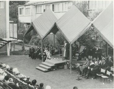 International House, The University of Melbourne
Photograph (Item), Aerial view of speakers and some audience members at the opening of the Samuel Wadham Wing at International House
... Black and white photo of Aerial view of speakers and some... Parade Parkville melbourne ceremony Black and white photo ...ceremony -
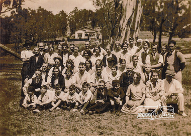 Eltham District Historical Society Inc
Photograph, Group from Brunswick ANA Lodge at Eltham, Nov. 1933
... . A review of a 1945 aerial photo shows only one house of similar.... A review of a 1945 aerial photo shows only one house of similar ...One of three photos. Group of people including children associated with the Australian Natives Association at an outing at Eltham Lower Park. The first image was reproduced in EDHS Newsletter No. 163 July 2005 following a query from Nillumbik Historical society (Gwen Myers) seeking information about the location of the photo. It was suggested that it may be Eltham Lower Park, however the house in the background did not appear correct. There were simliar but mirror imaged. A more recent review of these photographs (2023) suggests that the photos were actually taken in Bremners flats (present-day Wingrove Park) looking towards the house near the intersection of Main and Mount Pleasant roads - Mrs Bremner's house. The topograpghy is also more in fitting with this location than that of Eltham Lower Park. A review of a 1945 aerial photo shows only one house of similar style present in this location. Further reviews of photos taken in the 1950s by Grace Mitchell looking back towards Bremner Flats shows two trees close by on a lean similar to that in the photos.Inkjet-printed copy of sepia photographaustralian natives association, bremners flats, recruitment, wingrove park -
 Melbourne Legacy
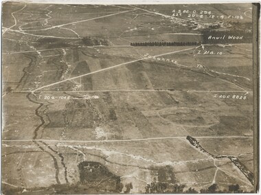
Photograph - Photo, Aerial view of the Somme
... An aerial photo of the Somme in France during World War One... An aerial photo of the Somme in France during World War One ...An aerial photo of the Somme in France during World War One. There are coordinates or numbers in some areas. Also labelled are the Johannes and Anvil Wood. Was with 11 other photos of World War One that had been mounted on board for display at Legacy House at some stage. When they were taken off display they were put in the archive cabinets. The founding legatees all served in World War One so these photos would have been of significant places for them. (see 01888 to 01899). From the AWM: Anvil Wood was a small wood to the north of Peronne that marked the centreline of an attack by the 14th Brigade on the morning of 1 September 1918. The northern approaches to Peronne were covered by numerous field and machine-guns, but the leading battalions of the brigade - the 53rd and 54th - pushed their attack home with determination, and sent the German defenders fleeing back to Peronne. The attack opened the way for the 14th Brigade to advance on to Peronne itself and break into the town's northern defences.Photos from World War One that would have been significant to the founding legatees.Sepia photo of the Somme battlefield in France during World War One.world war one, france, somme -
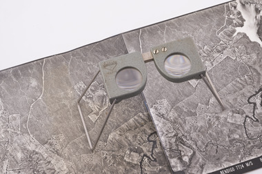
 Department of Energy, Environment and Climate Action
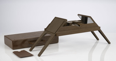
Foldable Stereoscope
... and overlapping aerial photos as a single three-dimensional image... and overlapping aerial photos as a single three-dimensional image ...This stereoscope was used to view a pair of separate and overlapping aerial photos as a single three-dimensional image. This smaller foldable unit could be easily used in the field but larger, mirror stereoscope was used in offices. The aerial images were used to map forest types, timber stands, new roads and tracks, firebreaks, boundaries of timber harvesting, plantations, bushfires, insect and disease attack and so on In 1928, the Forests Commission undertook its first major aerial photography project over 15,000 acres of forest which is said to be the first of its kind in Australia. During the Second World War, large areas of Victoria were photographed by RAAF and used to produce orthophoto maps. By 1945 aerial photography of 13,000 square miles (3.4 M ha) was completed, including much of the inaccessible eastern forests. The Forests Commission started developing its own small format photography in the early 1970s. Simple, cheap and rapid methods of obtaining photographs using 70mm and 35mm cameras were developedFoldable plastic stereoscope in box Benallaforests commission victoria (fcv), surveying, forest measurement -
 Department of Energy, Environment and Climate Action
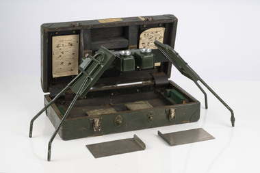
Stereoscope
... and overlapping aerial photos as a single three-dimensional image... and overlapping aerial photos as a single three-dimensional image ...This stereoscope was used to view a pair of separate and overlapping aerial photos as a single three-dimensional image. Smaller units and could be easily used in the field but this larger, mirror stereoscope was used in offices. The aerial images were used to map forest types, timber stands, new roads and tracks, firebreaks, boundaries of timber harvesting, plantations, bushfires, insect and disease attack and so on In 1928, the Forests Commission undertook its first major aerial photography project over 15,000 acres of forest which is said to be the first of its kind in Australia. During the Second World War, large areas of Victoria were photographed by RAAF and used to produce orthophoto maps. By 1945 aerial photography of 13,000 square miles (3.4 M ha) was completed, including much of the inaccessible eastern forests. The Forests Commission started developing its own small format photography in the early 1970s. Simple, cheap and rapid methods of obtaining photographs using 70mm and 35mm cameras were developedFoldable metal stereoscope in wooden box with mirror covers Ex Dept of Defenceforests commission victoria (fcv), surveying, forest measurement -
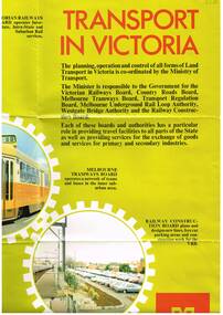 Melbourne Tram Museum
Poster, Minister of Transport, Transport in Victoria", late 1970's
... activities of the Boards, including an aerial photo of Melbourne CBD... of the Boards, including an aerial photo of Melbourne CBD from the south ...Full colour poster, single sided, printed on gloss white paper, titled Transport in Victoria", giving details of the functions and the various authorities and boards reporting to the Ministry of Transport. , Country Roads Board, Victorian Railways Board, Westgate Bridge Authority, Melbourne Tramways Board, Melbourne Underground Rail Loop Authority, Transport Regulation Board, Railway Construction Board Has photos of the various activities of the Boards, including an aerial photo of Melbourne CBD from the south east, showing the Flinders St rail yards. Photo of Z class tram, but number has been removed. Has the Ministry logo in the bottom right hand corner. See also Reg Item 1352 for a book of the same title.In ink in top left hand corner "4J40" - AETA Library location.trams, tramways, minister for transport, railways, trb, crb, murla -
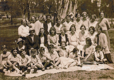 Eltham District Historical Society Inc
Photograph, Group from Brunswick ANA Lodge at Eltham, Nov. 1933
... . A review of a 1945 aerial photo shows only one house of similar.... A review of a 1945 aerial photo shows only one house of similar ...One of three photos. Group of people including children associated with the Australian Natives Association at an outing at Eltham Lower Park. The first image was reproduced in EDHS Newsletter No. 163 July 2005 following a query from Nillumbik Historical society (Gwen Myers) seeking information about the location of the photo. It was suggested that it may be Eltham Lower Park, however the house in the background did not appear correct. There were simliar but mirror imaged. A more recent review of these photographs (2023) suggests that the photos were actually taken in Bremners flats (present-day Wingrove Park) looking towards the house near the intersection of Main and Mount Pleasant roads - Mrs Bremner's house. The topograpghy is also more in fitting with this location than that of Eltham Lower Park. A review of a 1945 aerial photo shows only one house of similar style present in this location. Further reviews of photos taken in the 1950s ny Grace Mitchell looking back towards Bremner Flats shows two trees close by on a lean similar to that in the photos.Inkjet-printed copy of sepia photographaustralian natives association, bremners flats, recruitment, wingrove park -
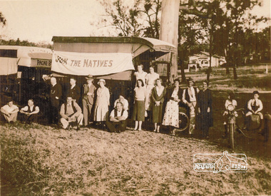 Eltham District Historical Society Inc
Photograph, Group from Brunswick ANA Lodge at Eltham, Nov. 1933
... that of Eltham Lower Park. A review of a 1945 aerial photo shows only one... that of Eltham Lower Park. A review of a 1945 aerial photo shows only one ...One of three photos. Group of people including children associated with the Australian Natives Association at an outing at Eltham. A truck displays a flag "Join the Natives". The first image was reproduced in EDHS Newsletter No. 163 July 2005 following a query from Nillumbik Historical society (Gwen Myers) seeking information about the location of the photo. It was suggested that it may be Eltham Lower Park, however the house in the background did not appear correct. There were simliar but mirror imaged. A more recent review of these photographs (2023) suggests that the photos were actually taken in Bremners flats (present-day Wingrove Park) looking towards the house near the intersection of Main and Mount Pleasant roads - Mrs Bremner's house. The topograpghy is also more in fitting with this location than that of Eltham Lower Park. A review of a 1945 aerial photo shows only one house of similar style present in this location. Further reviews of photos taken in the 1950s ny Grace Mitchell looking back towards Bremner Flats shows two trees close by on a lean similar to that in the photos. Inkjet-printed copy of sepia photographaustralian natives association, recruitment, bremners flats, wingrove park -
 Stawell Historical Society Inc
Photograph, Mick Walsh, Mick Walsh Stawell Studio Colour Negatives, 1975 to 1986
... Pigeons Ian Bryant Linda Clarke & Hank Woldhuis Philip West Aerial... Pigeons Ian Bryant Linda Clarke & Hank Woldhuis Philip West Aerial ...Negatives from Stawell Photographer. Discarded from Penna Print Ararat. Son contacted and gave approval for Stawell Historical Society to keep them. Only those of a non personal nature scanned. Ken German David Read Motors Graeme Healy Family Ann French Doug Cross Family Vikki & John Holcombe Family Kaye Ellen Family Jenkins Hand Heather Slorach & Rod Reading Pencker Family Pigeons Ian Bryant Linda Clarke & Hank Woldhuis Philip West Aerial Photos Mrs L Fielding 80th Show 1980 Lindsay Flowers Harrisons Wedding Cake Debbie Martin & Bob McGregor Rene Hall 80th Pool Game 1980 Mrs Coates 100th Ann Watson & Mike Farrell Glenda Smith & Geoff Lewin Nell Stewart & Liam Pickering SAAC 1980 Dadswells Stawell Brass Band Shuttleworth Dogs Helen Grace Cat Tina Walters Queens Scout Peel Family Trudy Harrison Grange Golf Slaughter House Suzanne Gercovitch & Gary Isbel Colour negatives of families, weddings and other. Nineteen Lever Arch Folders Mick Walsh 52 Patrick Street Stawellphotography -
 Forests Commission Retired Personnel Association (FCRPA)
Pocket Stereoscope
... and overlapping aerial photos as a single three-dimensional image... and overlapping aerial photos as a single three-dimensional image ...This pocket stereoscope was used to view a pair of separate and overlapping aerial photos as a single three-dimensional image. It was small and could be easily used in the field. Larger, mirror stereoscope were also available in some offices. The aerial images were used to map forest types, timber stands, new roads and tracks, firebreaks, boundaries of timber harvesting, plantations, bushfires, insect and disease attack and so on In 1928, the Forests Commission undertook its first major aerial photography project over 15,000 acres of forest which is said to be the first of its kind in Australia. During the Second World War, large areas of Victoria were photographed by RAAF and used to produce orthophoto maps. By 1945 aerial photography of 13,000 square miles (3.4 M ha) was completed, including much of the inaccessible eastern forests. The Forests Commission started developing its own small format photography in the early 1970s. Simple, cheap and rapid methods of obtaining photographs using 70mm and 35mm cameras were developed Small pocket stereoscope to interprete aerial photographs in the field Adjustable lenses on foldaway wire legsSokkisha Tokyoforest measurement, surveying, forests commission victoria (fcv) -
Glenelg Shire Council Cultural Collection
Photograph - Photograph - aerial view of Portland Harbour, n.d
... Aerial black and white photo showing a sheep ship at No.6... Authority Port of Portland Archives aerial photography Portland ...Port of Portland AuthorityBack: harb020- pencilport of portland archives, aerial photography, portland harbour, k s anderson wharf -
Tatura Irrigation & Wartime Camps Museum
Photograph, Eildon Township, 1957
... Medium sized black and white photo. Aerial photograph... sized black and white photo. Aerial photograph - looking down ...Taken by photographer for State Rivers and Water Supply Commission.Medium sized black and white photo. Aerial photograph - looking down on township in middle foreground - overflow dam to the right, middle distance - dam wall with reservoir beyond - mountain tops forming horizonOn frame below photo: "Eildon Township."victoria state rivers and water supply commission, eildon -
Glenelg Shire Council Cultural Collection
Postcard - Postcard - Nelson, Victoria, n.d
... Coloured photo postcard, aerial view of Nelson, Victoria...: Maker details. 'Aerial view of Nelson Victoria' Coloured photo ...Coloured photo postcard, aerial view of Nelson, Victoria, showing the bridge, township and river mouth. Rose Series De Luxe colorview NO 1213Back: Maker details. 'Aerial view of Nelson Victoria'postcard, nelson