Showing 550 items matching "early settlement"
-
 Flagstaff Hill Maritime Museum and Village
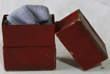
Equipment - Gauze & Box, Early - Mid 20th Century
... help in early settlement days of Victoria could take quite some ...When used as a medical dressing, woven gauze is usually made of cotton. It is especially useful for dressing wounds where other fabrics might stick to the burn or laceration. Many modern medical gauzes are covered with a perforated plastic film such as Telfa or a polyblend which prevents direct contact and further minimizes wound adhesion. Also, it can be impregnated with a thick, creamy mixture of zinc oxide and calamine to promote healing, as in Unna's boot. (An Unna’s boot is a special gauze (usually 4 inches wide and 10 yards long) bandage, which can be used for the treatment of venous stasis ulcers and other venous insufficiencies of the leg. It can also be used as a supportive bandage for sprains and strains of the foot, ankle and lower leg. The gauze is impregnated with a thick, creamy mixture of zinc oxide and calamine to promote healing. It may also contain acacia, glycerin, castor oil and white petrolatum.) Gauze is also used during procedures involving accidental tooth loss; either the gauze is used to provide pressure as the tooth is moved back into its corresponding socket, or the tooth is wrapped in gauze and placed in milk or saline to keep it alive while the tooth is being transported or prepared for reinsertion. https://en.wikipedia.org/wiki/GauzeAccess to emergency medical help in early settlement days of Victoria could take quite some time, especially in remote areas. From 1888 First Aid Kits and instructions became available for work sites, offices, community groups and individuals, helping to bridge the gap between the accident and the arrival of medical assistance. Gauze was widely used in many medical conditions.Gauze and maroon box with sliding top, purple bandage (gauze) inside. Gold rim top and bottom. None.flagstaff hill, warrnambool, shipwrecked-coast, flagstaff-hill, flagstaff-hill-maritime-museum, maritime-museum, shipwreck-coast, flagstaff-hill-maritime-village, first aid bandages, dressings, medical -
 Flagstaff Hill Maritime Museum and Village
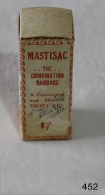
Equipment - Gauze & Box, Flexlock Products, Early - Mid 20th Century
... ://en.wikipedia.org/wiki/Gauze Access to emergency medical help in early ...When used as a medical dressing, woven gauze is usually made of cotton. It is especially useful for dressing wounds where other fabrics might stick to the burn or laceration. Many modern medical gauzes are covered with a perforated plastic film such as Telfa or a polyblend which prevents direct contact and further minimizes wound adhesion. Also, it can be impregnated with a thick, creamy mixture of zinc oxide and calamine to promote healing, as in Unna's boot. (An Unna’s boot is a special gauze (usually 4 inches wide and 10 yards long) bandage, which can be used for the treatment of venous stasis ulcers and other venous insufficiencies of the leg. It can also be used as a supportive bandage for sprains and strains of the foot, ankle and lower leg. The gauze is impregnated with a thick, creamy mixture of zinc oxide and calamine to promote healing. It may also contain acacia, glycerin, castor oil and white petrolatum.) Gauze is also used during procedures involving accidental tooth loss; either the gauze is used to provide pressure as the tooth is moved back into its corresponding socket, or the tooth is wrapped in gauze and placed in milk or saline to keep it alive while the tooth is being transported or prepared for reinsertion. https://en.wikipedia.org/wiki/GauzeAccess to emergency medical help in early settlement days of Victoria could take quite some time, especially in remote areas. From 1888 First Aid Kits and instructions became available for work sites, offices, community groups and individuals, helping to bridge the gap between the accident and the arrival of medical assistance. Gauze was widely used in many medical conditions.Gauze and box entitled "MASTISAC?. The Combination Bandage" Bandage is complete with instructions for use inside.Mastisac ‘The combination Bandage. A convenient and effective FIRST AID. Prepared and distributed by Flexlock products, 15 Mills Street, Albert Parkflagstaff hill, warrnambool, shipwrecked-coast, flagstaff-hill, flagstaff-hill-maritime-museum, maritime-museum, shipwreck-coast, flagstaff-hill-maritime-village, first aid, bandages, dressings, medical -
 Orbost & District Historical Society
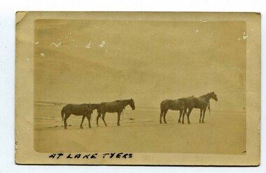
black and white photograph, late 19th century - early 20th century
In the late 19th century in the Orbost area roads were just bush tracks which generally were unsuitable for any type of vehicular traffic so were traversed mainly by horseback. As the settlement grew, a weekly mail service from Cunninghame (Lakes Entrance) was estab-lished. The settlers had to carry the mail for three months and each took a turn as mailman during that time. The first coach was driven by Mr Alex Hall. Eventually a daily mail service was set up and many drivers included B. Sutherland, W. Middleton, Jonson Bros., J. Mitchell, F. Newport, J. Geddes, A. Coulson, Bert Cessor, H. Weekes and A. Barthile. (info. from Newletter August 2007) This photograph is one of A. Coulson’s Coach crossing the Sand Bar at Lake Tyers.This is associated with early transport in East Gippsland.A black / white postcard photograph of four horses alone on a beach.on front - At Lake Tyers on back - "Mr A. Coulson, coach driver, Orbost"lake-tyers coulson-coach-driver transport-horse-drawn -
 Orbost & District Historical Society
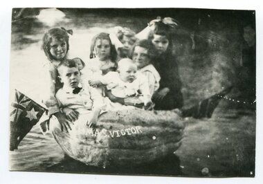
black and white photograph, Warren, Mrs H, first half 20th century
These children are the Rice family. In 1925 Walter Rice built a general store in Marlo and in 1930 built the "Ozone Picture Theatre" also in Marlo.This item is associated with a popular activity of the Orbost community in the first half of the 20th century. Pumpkins have been been part of the district's agricultural history since settlement. It is associated with Walter Rice a prominent citizen of Marlo in the early 20th century.A black / white photograph of a group of six children sitting in a pumpkin in water. there is a flag on each side and "HMAS VICTOR" on the side of the pumpkin.pumkins-orbost warren-helena rice-walter -
 Warrnambool and District Historical Society Inc.
Ledger, Warrnambool Municipal Common, Circa 1865
This cash book contains entries which relate to the everyday operation of the Borough Common which predates the establishment of Warrnambool as a town. All ratepayers had the right to graze their cows on the common, with the cows being collected every morning by the herdsman and walked to the common. Entries relate to items such as eradication of thistles, repairs and erection of stock yards, burying of dead stock, purchase of bulls and clearing of waterholes. Salaries were paid to E. Margetts, D Allan, T Raingill, and M T Read. Auditors were James Dickson. After WW1 parts of the common were allocated to soldiers’ settlement blocks ranging from 18 to 30 acres. Other parts remained with the Crown for Municipal uses and part became the Warrnambool Golf Course. In 1925 the common was abolished.The entries in this book record the operations and earliest residents who were involved in the Common in the early days of WarrnamboolGrey and red mottled card cover with dark green points and spine. Paper label on front cover. Dark blue and tan mottled paper inside front and back covers. Warrnambool Municipal Common Cash Book.warrnambool borough, warrnambool common, e margetts, raingill, d allan, m t read, warrnambool common cash book -
 Warrnambool and District Historical Society Inc.
Book - Facsimile: John Mackersey 1826-1892, Stock Book 1857-1870, 2014
... in the Western District of Victoria and it dates from a period of early ...This ledger relates to the property Kenilworth which is situated near Cavendish, 16 miles from Hamilton on the Wannon River. It was taken up by Thomas Norris in 1839 and originally carried 800 cattle and 20000 sheep on 63000 acres. By 1858 it was in the hands of John Mackersey and Thomas Bostock. In 1859 it belonged outright to John Mackersey who was there until 1870. He was considered a worthy son of a Presbyterian minister and was well regarded in the district for his contributions in church, sport and sheep breeding... However he did not do well and lost the property before going to New Zealand in 1870. These journals provide a yearly record of flock, harvest and yields along with income details. It also provides details relating to rentals, selections and purchases during the era from squatting to freehold land. This journal provides a detailed view of matters relating to the business of sheep farming. It records purchases and stock sold, wool clips, lambs, sheep losses and different breeds. Kenilworth was a significant property in the Western District of Victoria and it dates from a period of early settlement in Victoria.Dark green hard cover with gold lettering. Both covers have in gold lettering: John Mackersey1826-1892 Stock Book 1857-1870. One cover has Horses and cattle and the other, sheep. It is a facsimile copy. The two sections are divided by a green sheet of paper. Acknowledgements to The State Government of Victoria, State Library of Victoria, Hamilton History Centre, Dr G Handbury AO, Margaret Gardiner, Godfrey and Margaret Mackersey, L Alan Brumley, M P Heuval. john mackersey, thomas bostock, thomas norris, kenilworth, history of warrnambool -
 Warrnambool and District Historical Society Inc.
Book - Diary Facsimile: John Mackersey, Journal 1867-75, 2014
... . This journal provides an insight into early settlement in the Western ...John Mackersey farmed the property Kenilworth which is situated near Cavendish, 16 miles from Hamilton on the Wannon River. It was taken up by Thomas Norris in 1839 and originally carried 800 cattle and 20000 sheep on 63000 acres. By 1858 it was in the hands of John Mackersey and Thomas Bostock. In 1859 it belonged outright to John Mackersey who was there until 1870. He was considered a worthy son of a Presbyterian minister and was well regarded in the district for his contributions in church, sport and sheep breeding... However he did not do well and lost the property before going to New Zealand in 1870. This diary contains entries for the latter part of that period as well as entries from his time in New Zealand.This journal provides an insight into early settlement in the Western District of Victoria.Dark green hard cover with gold lettering on front cover. 210 Pages. Title page has photograph of diarist and period of entries. 10 Mar 1867- 6 Apr 1875. The pages are a copy of handwritten entries in his original diary.Acknowledgements to The State Government of Victoria, State Library of Victoria, Hamilton History Centre, Dr G Handbury AO, Margaret Gardiner, Godfrey and Margaret Mackersey, L Alan Brumley, M P Heuval. john mackersey, thomas norris, thomas bostock, kenilworth, warrnambool history -
 Warrnambool and District Historical Society Inc.
Book, Woolsthorpe Primary School and Woolsthorpe Soldier Settlement
History of the Woolsthorpe Primary School and Woolsthorpe Soldier SettlementThis is a soft-cover book with a blue and buff- coloured front cover featuring photographs of the Woolsthorpe Primary School and the Woolsthorpe War Memorial. The back cover has photographs of the R.S.L. Badge and the Woolsthorpe Primary School. It has 160 pages. non-fictionHistory of the Woolsthorpe Primary School and Woolsthorpe Soldier Settlementwarrnambool, woolsthorpe, soldier settlement -
 Warrnambool and District Historical Society Inc.
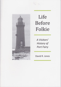
Booklet - Booklet about Port Fairy, Life before Folkie, 2013
This booklet aims to give a brief outline of Port Fairy’s history for the benefit of visitors. Port Fairy was an early sealing and whaling town with white settlement established by 1836. As the port and shipping declined so did the town until its reinvigoration in the mid 20th century as a tourist town and the home of the annual Port Fairy Folk FestivalThe book is of use as a quick reference to Port Fairy history.This is a booklet of 48 pages. It contains printed material, black and white photographs and a map. The front cover has a black and white image of the Port Fairy lighthouse. Front Cover: ‘Life Before Folkie, A Visitors’ History of Port Fairy, David R. Jones’port fairy, david r. jones -
 Warrnambool and District Historical Society Inc.
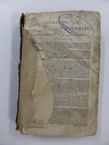
Book, Arithmetic, 1842
This is an early school arithmetic book with the front preface indicating it is the third edition published in 1842. The book appears to have been used about the 1860s by members of the Bell family who probably lived at Cudgee. The names of the children, presumably the Bell children, are scattered throughout the book – Margaret, Walter, Sarah and William. No information is available on this Bell family though there are records of births in Warrnambool of Bell children in the 1850s to William and Jane Bell. Cudgee, a small settlement on the Cudgee Creek, is about 16 kilometres from Warrnambool. This book is of some minor interest because of its age and because it has some association with the Bell family who may have lived at Cudgee in the mid 19th century. The exercises in the book are of interest as examples of the arithmetical problems given to children in the mid 19th century. This is a hard cover book of 282 pages. The cover is dark brown with gold lettering on the spine but the front cover and part of the first few pages are missing. The pages are ragged and dog-eared and quite dirty in places. There is handwritten material in both pencil and ink on the front pages, throughout the text and on the back page. ‘Margaret’ ‘Walter’ ‘Sarah’ ‘William Bell’ ‘Cudgee’ mathematics, bell family, cudgee, warrnambool history -
 Warrnambool and District Historical Society Inc.
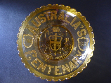
Plates x 4, Henry Greener and Company of Sunderland England, Souvenirs of Australian Centenary 1788-1888, 1888
These plates were pressed to commemorate the centenary of the European settlement of Australia. A large number were produced and the were distributed throughout AustraliaThese plates are a good example of souvenirs which were produced to commemorate the celebrations of the centenary of European settlement of Australia. The pressed glass was a common method of manufacturing around that period and of which they are an excellent example.001423.1 Large rounded amber glass dish with scalloped edge and seven fine rings below. Text is stippled glass on the back which appears through to the inside of the dish.An early version of Australian Coat of Arms is in the centre with the centenary years inside shields, either side. 001423.2 A smaller version of 001423.1 001423.3 Small clear glass saucer shaped dish with same design as the larger dishes. 001423.4 Small amber coloured shallow dish with small glass handle on each side. Pattern matching the larger plates is embossed on underside of the dish. The surface is scored acroos the centre bottom of the dish.Australia's Centenary in stippled glass around the edge of each dish. Advance Australia below the the Coat of Arms. 1788 1888. R*No 88120 behind one scallop on edge on each platewarrnambool, centenary of australia, centenary plates, 1788-1888 -
 Warrnambool and District Historical Society Inc.
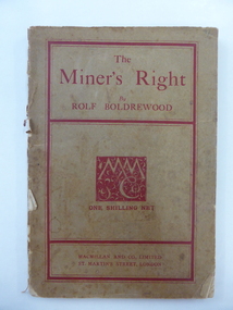
Book, The Miner’s Right, 1922
This book about the New South Wales goldfields was written by Rolf Boldrewood in 1890. It is retained because the author played a significant part in Warrnambool’s history. Rolf Boldrewood, the pen name of Thomas Browne, first came to the Warrnambool district in 1842, visiting the Bolden brothers’ property, Grasmere. He camped on the banks of the Merri River for about six months and described the area, including Warrnambool Bay, some years later in his book Old Melbourne Memories. In 1844 Thomas Browne established the property, Squattleseamere near Bessiebelle, north west of Portland. He remained there for ten years then moved to New South Wales. The last forty years of his life were spent writing and he became well-known for the classic Australian novel, Robbery Under Arms. This book is retained because it is a 19th century example of the writings of Rolf Boldrewood. He is important in Warrnambool’s early history as he was in the area in the early 1840s. His account of the area at that time is the most important one we have of the area that was later to be the site of the new settlement of Warrnambool.This is a soft cover book of 188 pages. The cover is brown with red edging and lettering and is partly detached from the binding. The spine is partly missing. The pages are dog-eared and there is some foxing. The text is printed in two columns to a page. Frank J. Donovanrolf boldrewood (thomas browne), bolden brothers in the warrnambool area, warrnambool history, the miners right -
 Warrnambool and District Historical Society Inc.
Book, New Testament The Queens Jubilee 1887, 1886
This book was printed to commemorate Queen Victoria’s Jubilee, 1887 (50th anniversary of her Coronation as Queen of England). John Markman is most likely the father or grandfather of Mary Snell (nee Markman). Mrs Snell was a teacher in Warrnambool and an active member of the Warrnambool and District Historical Society in its early years. She wrote the first book on the origin of street names in Warrnambool. Allendale is a small settlement in the Hepburn area of Victoria. This book is of minor interest as a memento of Queen Victoria’s 1887 Jubilee and as a book that appears to have come to the Historical Society via an early member, Mary Snell (nee Markman). This is a book of 240 pages. It has a black cover with the imprint on the front cover of a crown and shield and the words ‘The Queen’s Jubilee, 1887, Victoria’ and on the back cover a circular scroll with the words, ‘British and Foreign Bible Society, New Testament’. The cover has been bound with black tape and adhesive tape but the binding has come apart. Several pages are torn at the edges and dog-eared. ‘John Markman, Allendale, 17th June 1887’ Copy of Queen Victoria’s handwritten message - ‘On earth peace, goodwill toward men, Victoria, Windsor Castle, March 8,1887’ john markman, mary snell, history of warrnambool. -
 Warrnambool and District Historical Society Inc.
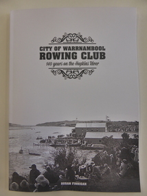
Book, City of Warrnambool Rowing Club, 2016
... recreational pursuit in Warrnambool since the early days of settlement ...This book gives the history of the Warrnambool Rowing Club. The club was formed in 1873. In 1885 Mrs Fanny Nelson built a boathouse on the Hopkins River bank and leased it to the Warrnambool Rowing Club. A two-storeyed building for the Rowing Club was opened in 1889 and today the club operates from Proudfoot’s Boathouse near the mouth of the river. This is an important book as it details the history of the Warrnambool Rowing Club. Rowing has been a popular recreational pursuit in Warrnambool since the early days of settlement as the proximity of two rivers makes this possible and the Warrnambool Rowing Club has a history well worth recording. This is a soft-cover book of 85 pages with a white cover with a black and white photograph on the front of the old rowing club sheds on the Hopkins River and several images on the back cover of Warrnambool in the 19th century. The book has eight chapters and has pages with information on life members and committees, a Foreword, a Contents page, an Acknowledgements page, an Index and Endnotes. The book is written by Susan FinneganFront Cover: ‘City of Warrnambool Rowing Club, 140 Years on the Hopkins River’warrnambool rowing club, warrnambool -
 Warrnambool and District Historical Society Inc.
Bottle, Bottle fragment Woodford hotel est 1845, 19th century
This fragment was found in Bridge Road, Woodford on the site of the Travellers’ Rest Hotel, Woodford and it is believed that it may date from the time when the hotel was operating. The Travellers’ Rest Hotel in Woodford was established some time in the 1840s with the first known date, 1847. It pre-dates the settlement of Warrnambool founded in late 1847. The Travellers’ Rest Hotel was established by William Kirby and his wife Mary took over the hotel management when her husband was drowned in August 1847. The hotel had seven other licensees and closed in 1875. If this item comes from the time of the Travellers’ Rest Hotel in Woodford then it is of considerable interest as an early memento of that hotel and the early days of Woodford. This is a fragment of a black bottle or other domestic item. It is made of heavy glass and is curved and could be part of the base of the object. history of woodford, travellers’ rest hotel, woodford, warrnambool history -
 Kiewa Valley Historical Society
Photographs x 2- D Reids home at Mill Park 1973, 2/12/1973
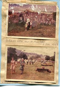
David Reid (1820-1906) was a pastoralists and politician. He left school at 16 and after meeting the overlander John Gardiner he decided to look for land south of the Murray River. Equipped by his father with some 500 head of cattle, 2 bullock wagons and teams and 6 assigned servants, he reached the Ovens River on 8 September 1838. David settled at Currargarmonge, near Wangaratta. At the end of 1843 he took up land near Yackandandah. In 1847 he took up a section of the family run of which Woorajay (Wooragee) formed a part. He built the first water driven flour-mill in the district on his Yackandandah run in 1845; his woolclip of 1848 was one of the first to be handled by R. Goldsbrough and was claimed to come from sheep descended from stock imported in the 1820s from George III's flock. Going into politics, he held the Legislative Assembly seat of Murray from October 1859 to May 1862. David Reid was a highly regarded grazier and local politician who was significantly involved in settlement around the Yackandandah area. Photo demonstrates ongoing interest in the local history of the area and its early residents2 colour photographs mounted together on buff card 1. Man and 2 children (unidentified) standing outside the remains of the Reid home. 2 Dec, 1973 2. Group of unidentified people on a tour of the old homestead of D. Reid. 2 Dec, 19731. Handwritten in black ink under photo 'D. Reid's home 1845. At Mill Park. 2 Dec 1973 2. Handwritten in blue ink under photo 'Snapshots Clare Roper"clare roper -
 Kiewa Valley Historical Society
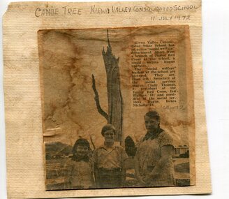
Newspaper clipping 11/7/72 Canoe tree in Kiewa & Photo-Tawonga Homestead
1. Kiewa Valley Consolidated School was established in 1953 combining Dederang North, Kergunyah, Gundowring, Kiewa, Gundowring Upper, Red Bluff, Charleroi and Gundowing North schools on a 10 acre site with 11 rooms at Kiewa. The bark was cut from the canoe tree, by aboriginal craftsmen, to produce a canoe for fishing in the rivers running through the Kiewa Valley either before or just after the 1800's. The tree trunk, located at Kiewa, would have been used at the beginning of European settlement in the Kiewa Valley or just before contact was made. 2. Pictorial record of the graves of early pioneers C Ibbotson, Mrs Elizabeth Eyre and John Eyre who died between 1858 – 1904, all located at Tawonga Homestead 1. The above schools are in the Kiewa Valley. The date and number of combined schools give insight into the change in population and families in the Kiewa Valley before and after 1953. The tree was found along the Kiewa River and indicates that Aborigines lived by the river and used tree bark to craft canoes to cross rivers and to fish in the deeper sections of the river. 2. Pictorial record of the early history of Kiewa Valley pioneers whose descendants have lived and worked in the Kiewa Valley for many years 1. Newspaper article of local school children visiting a canoe tree in Kiewa July 11, 1972. mounted on buff card 2. Black and white photo of pioneer graves at old Tawonga Homestead. Mounted on buff card 1. Handwritten in black ink above newspaper clipping ‘Canoe Tree Kiewa Valley Consolidated School. 11 July, 1972’ Handwritten in pencil at bottom of article ’10 Nov. ‘72’ 2. Handwritten in black ink above photo ‘Tawonga Homestead graves’ Handwritten below photo ‘T Ibbotson D. 1858, Elizabeth Eyre D. 1879, John Eyre D 1879, John Eyre D. 1904 tawonga homestead, canoe tree at kiewa, tawonga graves -
 Kiewa Valley Historical Society
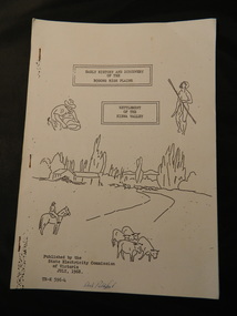
Booklet - Bogong High Plains & Kiewa Valley, Early History & Discovery of the Bogong High Plains & Settlement of the Kiewa Valley, July 1968
A brief history of the area including the Bogong High plains including aborigines and cattlemen. Settlement of the Kiewa Valley including cattlemen and families. A list of the Origin of names of places in the valley.SECV published this booklet using research resources available at the time and using current knowledge with regard to naming of places where the SECV worked and 'created'.Light cardboard cover with 3 staples and with 9 pages printed on one side. Text is boxed. Front cover has 5 simple sketches each of which covers the topics included in the booklet."Dick Puttyfoot" on front coverstate electricity commission of victoria., kiewa hydro electric scheme, kiewa valley, bogong high plains -
 Warrnambool and District Historical Society Inc.
Booklet - Booklet: Settlement of the Western District, Collett, Bain and Gaspar, Printers, Settlement of the Western District From Prehistoric Times to the Present, 1985
This booklet documents a public lecture series held in Warrnambool 3rd November 1984.This is a soft-cover book of 133 pages on the settlement of the Western District from prehistoric times to the present. It has a blue paper front cover and a grey paper back cover. The front cover is covered with a clear plastic sheet and the binding is plastic. The cover has an image of a sketch of the Warrnambool beach showing the lighthouse complex on Middle Island and the lighthouse on the beach (established 1860). There are a Contents page, a Foreword, a List of Plates and seven articles on different aspects of the Western District history by different authors. There are black and white photographs and illustrations. One page (p.17) has been annotated by Les O’Callaghan.This booklet documents a public lecture series held in Warrnambool 3rd November 1984.western victorian history, edmund gill, peter ronald, john sherwood, jan critchett, tony dingle, miles lewis, kevin o’toole, warrnambool, history -
 Warrnambool and District Historical Society Inc.
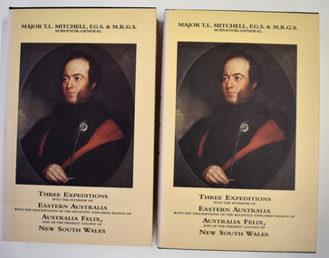
book - Books, Eagle Press, Mitchell's Three Expeditions into Eastern Australia, 1996
Major Thomas Mitchell historical writing.This is set number 223 of two facsimile volumes of an historical work. The covers are green with gold printing and the dust covers are cream with black printing and two colour illustrations. The pages contain printed text and illustrations, both black and white and coloured. There are two inserts, one a map and the other showing a New South Wales natural feature. The two volumes are contained in a hardcover green folder.non-fictionMajor Thomas Mitchell historical writing.major mitchell, australia felix squatting period -
 Warrnambool and District Historical Society Inc.
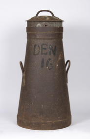
Container - Milk can, Early 20th century
This is a can used for storing milk at a dairy farm for transport to the local butter, milk or cheese factory. It comes from a farm (number 16) in Dennington, a settlement and now a suburb west of Warrnambool. It may have been supplying milk to the Nestles factory at Dennington by a truck or taken to a Nestles depot nearby. The Nestles factory was established in Dennington in 1907 and closed in 2005. This can is an interesting memento of dairying practices in the early to mid 20th century.This is a metal can with a circular base tapering to an open top. It has two handles on the side and a circular lid with a handle. It has a stencil on the side. The entire can is rusted.Den 16milk can, dairying in warrnambool district, nestles factory dennington -
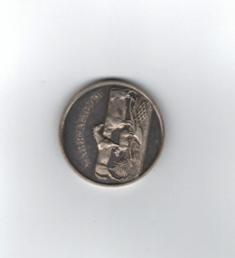 Warrnambool and District Historical Society Inc.
Medal, Villiers and Heytesbury Agricultural Association (Daniel Hourigan 1877), C 1877
... feature of agricultural life in Victoria since the early days ...This medal was awarded at the Villiers and Heytesbury Agricultural Association Annual Show to Daniel Hourigan in 1877 for his yearling colt by 'Prince of the Isles'. The formation of the Villiers and Heytesbury Agricultural Association arose out of a meeting at Woodford in 1853 and the first Show was held in Warrnambool in 1855 on a green bound by Fairy, Henna and Koroit Streets. It was held there until 1875 when it moved to the present Warrnambool Showgrounds in Koroit Street. At the 37th Annual Show in 1890 Warrnambool held its first Grand National Show, a title granted by the Chamber of Agriculture in Victoria. The Villiers and Heytesbury Agricultural Association became known as the Warrnambool Agricultural Show in 1911. Daniel Hourigan was a farmer, road contractor, poundkeeper and auditor who lived in the Tower Hill area in the 19th century. This medal is of considerable interest as it is a memento of the Villiers and Heytesbury Agricultural Association Annual Show in the 19th century. Annual Agricultural Shows have been an important feature of agricultural life in Victoria since the early days of European settlement and a feature of agricultural life in the Warrnambool district since the 1850s. The medal is also of great interest because it was awarded to Daniel Hourigan, a prominent settler in the Warrnambool district in the 19th century. .1 Circular silver disc with image of horse, bull, sheep, wheat sheaf and plough on the reverse with script around edge of obverse with awardees details engraved in the centre. Edge of the medal is plain. .2 Square maroon leather case with small metal clasp and hinge. Lined on the interior with blue velvet and cream silk.Obverse :" Warrnambool" engraved above image of cattle. W J Taylor London Reverse : Villiers & Heytesbury Agricultural Association in low relief around the edge. 1st prize awarded to Daniel Houriganfor yearling colt , "Prince of the Isles Annual Show 10th October 1877.warrnambool, villiers and heytesbury, daniel hourigan, prince of the isles, 1877, villiers & heytesbury agricultural show -
 Warrnambool and District Historical Society Inc.
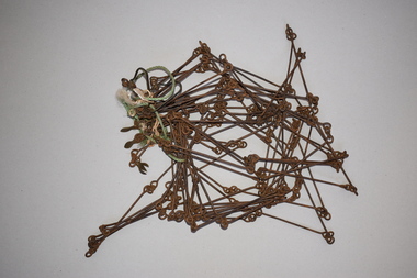
Chain link measure, Gunter, Early 20th century
This Gunter’s Chain, an old land surveying instrument, is named after its inventor, Edmund Gunter (1581-1626), an English mathematician and astronomer. It was first produced in 1620. The tool has 100 links and is 66 feet or one chain long. The links are marked off in groups of ten by metal rings or tags. A quarter chain (25 links) is called a rod or pole and ten chains make a furlong and 80 chains make a mile. The traditional cricket pitch is 22 yards or one chain long. This Gunter’s Chain is of considerable significance because: 1. It is an early land measuring tool that was used for over 250 years and has great historical and mathematical significance. A Gunter’s Chain would have been used when forming and building local roads from the earliest days of settlement. 2. It has a possible local connection as it was given to the Historical Society by a local person in 1965 and possibly came from the property of ‘Rosehill’ This is a metal tool which consists of 100 metal pieces or links joined together by loops at each end with two metal loops in between each link. The links joined together form a chain. The two ends of the chain have small metal handles attached At intervals along the chain there are additional rings or metal pieces attached. Some white and green rope material has been used to bundle up the chain. The metal is somewhat rusted. gunter’s chain, land measurement tools, history of warrnambool -
 Warrnambool and District Historical Society Inc.
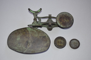
Scales, W. & T. Avery Ltd. Mill Lane Works, Nullawarre PO & tray + 2 weights, Early 20th century
These scales come from the Nullawarre Post Office and would have been used there for most of the 20th century. Nullawarre is a small settlement 25 kilometres south east of Warrnambool. It was first settled in the late 1860s and 70s and the main agricultural pursuit for the area today is dairying. The first Nullawarre school was opened in 1878 and the Nullawarre Post Office operates today in the Nullawarre General Store. These scales are of interest as a memento of the type of weighing scales used in Post Offices in Victoria in the early to mid 20th century. They are also of local interest as they come from the Nullawarre Post Office.This is a metal set of scales with a balance mechanism on a metal stand. The balance has a circular tray at one end to hold weights An oval dish to hold items to be weighed is a separate item that sits at the other end of the balance. The scales were once painted green and some traces of the green paint are visible. Two weights are with this item. The scales are much rusted. ‘W & T Avery Ltd Birm.’nullawarre, victoria, history of warrnambool -
 Warrnambool and District Historical Society Inc.
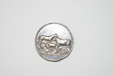
Medal, Villers & Heytesbury, 1879
... and a person concerned with the history of the early settlement ...This splendid medal was awarded by the Villiers and Heytesbury Agricultural Association in 1879. This association held its first show in Port Fairy in 1854 and in Warrnambool in 1855. It continues to this day under the name of the Warrnambool and District Agricultural Society. The medal was awarded to James Astley Bromfield, am early Warrnambool chemist who arrived in Victoria in 1852 and is significant in Warrnambool’s history. He produced the 1856 map of the Warrnambool district with the first landowners, a seminal resource for historians and was prominent in community affairs, especially in horse racing. He was also a Warrnambool and Shire Councillor. The medal was awarded for the best blood yearling of 1879 and this was Fright, one of the progeny of the famous stud horse Panic (second in the Melbourne Cup, 1865), His progeny won many hurdle races and flat races including the Melbourne Cup. The medal features also the names of two donors of prizes to James Bromfield, Henry Phillips and Francis Tozer, both pioneer men in Warrnambool’s horse racing history. Henry Phillips was the first President of the Warrnambool Amateur Turf Club and had the horse Panic standing at his 1000 acre stud, Bryan O’Lynn, at Purnim in the Western District. Francis Tozer was an owner, breeder and steward in racing circles and in the 1870s had the 2000 acre stud farm, Wangoom Park, at Wangoom, near Warrnambool.This is a most significant item as it was awarded to James Astley Bromfield, an early Warrnambool chemist and a person concerned with the history of the early settlement of Warrnambool and one prominent in community affairs in Warrnambool in the 19th century. The item also has connections with the famous stud horse, Panic and two other noted personalities of Warrnambool and district, Francis Tozer and Henry Phillips. The item also is of intrinsic monetary value as a 19th century medal from the Villiers and Heytesbury Agricultural Association. This is a round silver medal. It has etched printing on one side and raised images of farm animals and farm implements on the other side. It also has etched printing around the edge of the medal. There are some slight dents around the edge of the medal.‘Villiers & Heytesbury Agricultural Association 1st Prize Awarded to J. A. Bromfield for Blood Yearling 1879 ‘Fright by Panic’ Warrnambool Oct. 16 1879’ ‘Also Phillips and Tozer’s Special Prizes’ james astley bromfield, warrnambool, villiers and heytesbury agricultural association, henry phillips, warrnambool, francis tozer, warrnambool, history of warrnambool -
 Warrnambool and District Historical Society Inc.
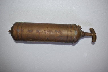
Fire Extinguisher, Pyrene Co Ltd, Mid 20th century
This fire extinguisher was used for commercial purposes in the Nullawarre Post office. The item was made in England by the Pyrene Co Ltd (1914-1971), one of the world’s leading manufacturers of fire fighting equipment in the early to mid 20th century. The extinguisher had a pump action and probably contained carbon tetrachloride. Nullawarre is a small agricultural settlement 25 kilometres south east of Warrnambool. The Nullawarre area was settled in the late 1860s and 1870s and today has a store and Post Office and a school. Charles Williams was the Post Master at Nullawarre in the early to mid 20th century and also delivered the mail. His wife, Vida was the Post Mistress. This fire extinguisher is of interest firstly as an example of a common item used commercially in the past and secondly as an item that came from the Nullawarre Post Office, used in this commercial building in the early to mid 20th century. This is a metal fire extinguisher which has been painted but the paint is mostly worn away. It is cylindrical in shape with ridged areas at the base and top. It has a clip handle. The cylinder is empty.‘Pyrene’vintage fire extinguishers, nullawarre post office, warrnambool -
 Warrnambool and District Historical Society Inc.
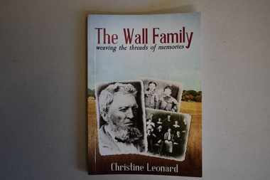
Book, The Wall Family - Weaving the Threads of Memories, 2021
Historical details of William Wall and his family and descendantsThis is a book of 172 pages. The front cover has three black and white photographs with a background of a colour photograph of a country scene. The printing is red, white and blue. The back cover has red printing and a colour plan of country allotments. . The pages contain printed text, black and white photographs and other images. non-fictionHistorical details of William Wall and his family and descendantswilliam wall, hotels of warrnambool and district -
 Warrnambool and District Historical Society Inc.
Map - Farnham Survey, 1850s
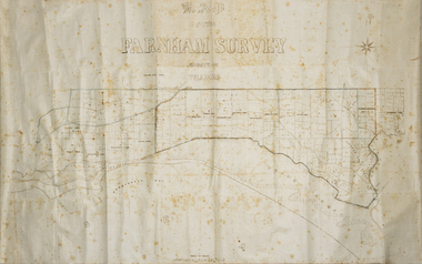
This is a map of the Farnham Special Survey. In 1843 William Rutledge purchased this Special Survey of 5,120 acres and named it Farnham. This Survey extended from Tower Hill to the Merri River at Dennington. The map appears to date from the 1850s This early map is of considerable significance as it shows details of the Farnham Special Survey. William Rutledge and his survey are important influences in the development of Warrnambool and district with the establishment of settlements at Killarney, Yangery and Tower Hill.A hand drawn map on waxed paper in brown, black and blue ink. It shows Armstrong's Bay, sea, Crown Land , the names of properties and some roads. It includes a compass direction diagram.farnham special survey -
 Eltham District Historical Society Inc
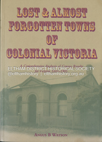
Book, Angus B. Watson, Lost & almost forgotten towns of colonial Victoria : a comprehensive analysis of census results for Victoria, 1841-1901, 2003
Lists all towns and villages with entries in the Victorian censuses between 1841 and 1901. It includes in excess of 1400 entries with the latitude and longitude for each town, numbers males and females in the town, and the number of occupied dwellings (where available). For many of these settlements the only visible trace of them today is in the census results collected by the fledgling governments of Colonial Victoria. It is a comprehensive reference and a fascinating insight into the movements of early populations of new Australians.cities and towns victoria, history 19th century, statistics, ghost towns - victoria, geographical names victoria, victoria census -
 Eltham District Historical Society Inc
Photograph - Digital Photograph, Alan King, St Margaret's Anglican Church, Pitt Street, Eltham, 30 January 2008
St Margaret’s Church of England was officially opened on December 12, 1861. It is the oldest intact church building in Eltham. At the time it was known as Christ Church until its consecration in 1871, when it was completely free of debt (£1,700 for the church and parsonage) despite the district’s poverty. This was largely due to the free labour and materials, including locally made bricks donated by local artisans and others. The church is historically significant because it is the oldest church in the former Shire of Eltham and has associations with the philanthropist and founder of Brighton, Henry Dendy (who donated the land on which the church is built), the architect Nathaniel Billing and the prominent local builder, George Stebbing. The church is architecturally and aesthetically significant because it is constructed in the Gothic Revival style with several stained-glass windows of various dates and is also a very early use of polychromatic brickwork in Victoria. Billing was one of the first Melbourne architects to employ polychromatic brickwork and an important early architect. The rear wall was intended to be temporary. A major feature of the design is the large buttresses with long, steeply graded upper faces. The overall design is well proportioned with the surface brick patterns relieving an otherwise austere design. The church is spiritually and socially significant because it has been an important place of worship for the people of Eltham for almost 150 years. The land on which the buildings stand was donated by Henry Dendy. Dendy arrived in Melbourne in 1841 after purchasing in England eight square miles at Brighton under the system of "special surveys". After this land passed out of his hands, Dendy moved about Victoria, visited England, then returned to settle in Eltham where he purchased a flour mill. Dendy chaired the meeting held in 1860 “for the purpose of devising such means as may be expedient for the establishment of a Church of England in the township of Eltham”. He became chairman and treasurer of the church committee. Unlike the establishment of many early churches in Victoria where a vicar was appointed to a parish and later a permanent church was constructed, the population at Eltham initiated action to build a church. The nearest church at that time was at Heidelberg and the Eltham settlement was part of the parish of St Johns Heidelberg. Isolation and the tedious, time consuming journey between Heidelberg and Eltham resulted in the Eltham community taking its own action. The original vicarage (Dendy House) at the rear of the church is also an important part of the cultural significance of this place because it is connected to the church and the development of the Eltham area. Together, the church and the vicarage are aesthetically significant because they form a significant streetscape feature. The mud-brick community hall designed by Robert Marshall was added in 1978. In 2014 the original temporary rear wall was removed as part of a modern extension designed by Architects Atelier Wagner and constructed by Conrad Construction and Management. Covered under Heritage Overlay, Nillumbik Planning Scheme. National Trust of Australia (Victoria) State significance Victorian Heritage Published: Nillumbik Now and Then / Marguerite Marshall 2008; photographs Alan King with Marguerite Marshall.; p67This collection of almost 130 photos about places and people within the Shire of Nillumbik, an urban and rural municipality in Melbourne's north, contributes to an understanding of the history of the Shire. Published in 2008 immediately prior to the Black Saturday bushfires of February 7, 2009, it documents sites that were impacted, and in some cases destroyed by the fires. It includes photographs taken especially for the publication, creating a unique time capsule representing the Shire in the early 21st century. It remains the most recent comprehenesive publication devoted to the Shire's history connecting local residents to the past. nillumbik now and then (marshall-king) collection, eltham, st margaret's anglican church, st margaret's church, christ church