Showing 430 items matching "geography"
-
 Warrnambool and District Historical Society Inc.
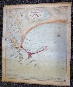
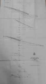
Map - Warrnambool Port 1879, 1879
The port facilities in Warrnambool Bay were in constant use from the first years of Warrnambool’s settlement but there were also difficulties for the shipping trade – a small and unsafe anchorage, the lack of loading facilities and little natural protection from the southerly gales. From the 1870s on there was local agitation for some sort of Breakwater to be built and an Andrew Kerr design was approved by the Warrnambool Council but no funds were made available from the Victorian Government. Throughout the 1870s the building of a Breakwater was a major political issue in the district with preliminary work being funded and started in 1874. In 1879 the Government agreed to a further inspection of the area and an official report. Sir John Coode (1816-1892) was commissioned to make this report. He had come to Australia in 1872 to advise on harbour construction. Coode recommended a 1800 feet long Breakwater and wharf connected to the shore and it was this proposal that the plan described herein and drawn up in 1879 was to accompany. The original plan was eventually modified because of the cost and a Breakwater was completed in 1890 under the direction of the engineer, Arthur Dudley Dobson, with extensions early in the 20th century. This plan is of great interest as it shows in simple graphic form the original plans proposed by Sir John Coode for the Warrnambool Breakwater. It is therefore of great historical importance. The Breakwater was not the maritime success that it was hoped it would be but it is today a significant feature of our foreshore. This is a Plan drawn up in 1879 by Victorian Harbours to accompany Sir John Coode’s Report on the proposed Warrnambool Breakwater. The chart detail is hand-drawn and hand-tinted on canvas with the names of places, geographical and marine features and local points of interest added in print. The edges of the chart are rubbed and the chart is somewhat faded and dirty but the main colours of red, green and brown are still clearly discernible. The title of the plan is printed in an oval inset at the top of the chart. The plan shows two possible Breakwater designs, one from the Borough Surveyor (Andrew Kerr?) and one from Sir John Coode.Victorian Harbours Warrnambool Plan to accompany Sir John Coode’s report Dated 28th Feby 1879 warrnambool breakwater, andrew kerr, sir john coode, arthur dudley dobson, warrnambool, warrnambool harbour, warrnambool history, warrnambool beach -
 Bendigo Historical Society Inc.
Book - LYDIA CHANCELLOR COLLECTION: PHILLIPS' COMPREHENSIVE ATLAS
A gray hard covered atlas titled ' Phillips' Comprehensive Atlas of Ancient and Modern Geography.' Edited by William Hughes, FRGS. London. George Phillip and Son, 32 Fleet St., Liverpool, Caxton Buildings, South John St., 1874. 42 pgs., maps, index. NB: In the inside cover of the book is a newspaper cutting of a letter from G. Wilson Brown Secretary, Education Department, Melbourne, 12th November, 1878 advertising 'an examination of Teachers and Candidates will be held at School 1,976, Sandhurst, on Thursday and Friday, 19th and 20th December, 1878, commencing at 9.30 a.m.'Edited by William Hughes, F.R.G.S.map, lydia chancellor collection, collection, atlas, maps, world, book, books -
 Kiewa Valley Historical Society
Atlas Australian Commonwealth, Philips' Australian Commonwealth Atlas, 1944
This atlas, printed in 1944, details not only the geographic and political boundaries of the world as it was at that time but also the snap shot of life of the time. This snap shot in time covers the major Australian cities, the major farming, grazing, industrial and sporting/recreational activities. Also there are snap shots of similar activities from other global areas. The period also covered World War II, detailed by a photo of "shell making", munitions, required by Australian soldiers. The great political and territorial changes made as a result of World War II can be clearly identified for example , Israel (the Jewish homeland). The various prewar colonies of major European nations.This atlas was used by children of a Kiewa Valley family and shows the value and the general educational exposure that these children had at this time. The rural setting and within the backdrop of a world war did not severely alter the life style of children in this region. The "news reels" shown in cinemas of cities and larger towns were the only visual realisations of major events of global significance available to these children. The information provided by this atlas allowed students to glimpse at what the "outside world" was. The majority of these students would possibly never see these regions for themselves. The great communication facilities of the late 1900s and beyond, was still only science fiction.This atlas has a thick (350 g/m) red cardboard cover with bold black lettering and shading. The cover is set out within a shield like frame. The shield is held up by two square markings, each with a four part circular pattern and a cord entwining two pendulum structures ending with a bowl figure at the bottom. There is a semi circular form enclosing a printed book contents list. The inside cover has the atlas title and contents and the publisher details. The atlas contain 56 pages of world and Australian maps, vegetation and rainfall maps. Within this atlas there are 27 double sided pages of black and white photographs depicting life styles, buildings, landscapes and prominent and significant to Australia males from 1652 to 1944. The pages are of approximately 200 g/m and have the yellow aged appearance.On front cover "Philips' Australian COMMONWEALTH ATLAS" and underneath "Containing" underneath "60 PHYSICAL, POLITICAL AND ECONOMIC MAPS". Publisher George Philip & Son, Limited 32 Fleet Street, London E.C. 4. Inside cover are: written, in freehand and in ink the following names and dates; "J.Muller Form V 1945", "L L Muller Form IV 1946", "N.J. Muller Form I + II + III 1948 +49 + 50" and "D Muller Form I 1949". also handwritten and in pencil is "Peter Leslie". On the last page is a small freehand sketch of Australia in biro.1940s school curriculum, rural education, 1940s atlas, australian atlas -
 Federation University Historical Collection
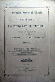
Book, Prodromus of the Palaeontology of Victoria No iv, 1876 (exact)
This publication consists of many Decades which contain "figuers and descriptions of the fossil organic remains to be used for the determination of the geological ages of the different geological formations of the country." (p. 3). Frederick McCoy was born in Dublin, Ireland in 1817. He was a Professor of Natural Sciences, University of Melbourne 1854-1899. McCoy lectured in geology, zoology, chemistry, mineralogy, geography and botany. In 1858 He became the Director of the National Museum of Victoria and the President of the Royal Society of Victoria in 1864. In 1888, McCoy was awarded FRS for work in Palaeontology in Ireland, England and Australia. He died in his office while correcting examination papers in 1899A Paperback cover book. Decade IV. Title is written in black on front cover and on title page. At head of title: Geological Survey of Victoria. Illustrations, plates in b/w; 32 p. It includes figures and descriptions of Victorian Organic Remains and contents of Decades on the back cover of the book.australia palaeobotany, victoria palaeontology, geological survey of victoria, frederick mccoy, organic remains -
 Federation University Historical Collection
Book, Prodromus of the Palaeontology of Victoria, 1877 (exact)
This publication consists of many Decades which contain "figuers and descriptions of the fossil organic remains to be used for the determination of the geological ages of the different geological formations of the country." (p. 3). Frederick McCoy was born in Dublin, Ireland in 1817. He was a Professor of Natural Sciences, University of Melbourne 1854-1899. McCoy lectured in geology, zoology, chemistry, mineralogy, geography and botany. In 1858 He became the Director of the National Museum of Victoria and the President of the Royal Society of Victoria in 1864. In 1888, McCoy was awarded FRS for work in Palaeontology in Ireland, England and Australia. He died in his office while correcting examination papers in 1899.A Paperback cover book. Decade v. Title is written in black on front cover and on title page. At head of title: Geological Survey of Victoria. Illustrations, plates in b/w; 41 p. It includes figures and descriptions of Victorian Organic Remains and contents of Decades on back cover.Stamped Ballarat East Public Library"australia palaeobotany, victoria palaeontology, geological survey of victoria, frederick mccoy, organic remains, ballarat east library, ballarat east public library -
 Federation University Historical Collection
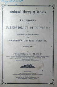
Book, John Ferres, Government Printer, Prodromus of the Palaeontology of Victoria Decade vi, 1878 (exact)
This publication consists of many Decades which contain "figuers and descriptions of the fossil organic remains to be used for the determination of the geological ages of the different geological formations of the country." (p. 3). Frederick McCoy was born in Dublin, Ireland in 1817. He was a Professor of Natural Sciences, University of Melbourne 1854-1899. McCoy lectured in geology, zoology, chemistry, mineralogy, geography and botany. In 1858 He became the Director of the National Museum of Victoria and the President of the Royal Society of Victoria in 1864. In 1888, McCoy was awarded FRS for work in Palaeontology in Ireland, England and Australia. He died in his office while correcting examination papers in 1899.A Paperback cover book. Decade VI. Title is written in black on front cover and on title page. At head of title: Geological Survey of Victoria. Illustrations, plates in b/w; 42 p. It includes figures and descriptions of Victorian Organic Remains and contents of Decades at back of the book.australia palaeobotany, victoria palaeontology, geological survey of victoria, frederick mccoy, organic remains, john ferres -
 Federation University Historical Collection
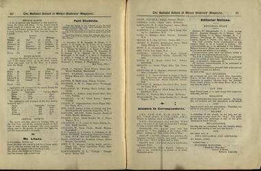
Magazine of 24 pages, Baxter & Stubbs, Print, Ballarat School of Mines, Student Magazine, Third Term, 1911, 1911
Table of Contents: Editorial, Inventions and inventors, The hydroplane launch "Maple Leaf III", Hints on examination, First aid, Some geographical features at Ballarat, The volumetric determination of potassium, Milk, The cannon, A scientific apologue, New inventions by Tesla, Coronation fair, First aid, Cinematography, Electrical chatter, Education and training of engineers, Mining notes, Engineering students midwinter excursion, Hints to S.M. B. yachtsmen, News and notes, The long and short of it, Abbreviated account of the geology of the Forbes-Parkes gold field, Excursion to Pyke's Creek Reservoir, A practical joke, Sports, Past students, Answers to correspondents, Editorial notes.table of contents: editorial, inventions and inventors, the hydroplane launch "maple leaf iii", hints on examination, first aid, some geographical features at ballarat, the volumetric determination of potassium, milk, the cannon, a scientific apologue, new inventions by tesla, coronation fair, first aid, cinematography, electrical chatter, education and training of engineers, mining notes, engineering students midwinter excursion, hints to s.m. b. yachtsmen, news and notes, the long and short of it, abbreviated account of the geology of the forbes-parkes gold field, excursion to pyke's creek reservoir, a practical joke, sports, past students, answers to correspondents, editorial notes., alumni: w. k. clifford, j. adam, wilfred avery, h. baxter, l. w. g. buchner, h. caulfield, a. cropper, e. b. crossley, w. currie, dave don, hilary dowling, chas fraser, a. d. galloway, w. geldard,t. e. copeland, l, j. coulter, j. dickinson, g. h. hall, godfrey s.hart, w. b. hirt, h. e. hawkesworth, oliver e. jager, carl janssen, w. t. lakeland, l. j. lambert, c. lund, r. i. moore, byron k. moore, f. a. moss, jack orr, douglas runting, w. t. sayer, l. seward, h. s. sheppard, c. e. sands, n. stuckey, r. vale, r. watts, reg williamson, w. baragwanath, c. c. corrie, r. g. walker, g. g. sams, r. a. j. roberts, r. blight, h. cornell, v. booth, miss l johnson. -
 Koo Wee Rup Swamp Historical Society
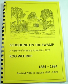
Book, Koo Wee Rup Primary School, Schooling On The Swamp, November 2009
History of Koo Wee Rup Primary School. Includes information about other schools (past and present) in Koo Wee Rup Swamp area : Bayles, Caldermeade, Cardinia, Catani, Cora Lynn, Dalmore East, Iona, Island Road, Koo Wee Rup North, Koo Wee Rup South, Heath Hill, Lang Lang, Protectors Plains, Modella, Tooradin, Tooradin North, Yannathan, Yannathan South. School Centenary History updated and expanded for 125 anniversary of Koo Wee Rup Primary School (1884-2009) Includes brief account of geography of Koo Wee Rup Swamp, and local indigenous people.A history of Primary School No. 2629, Koo Wee Rup : 1884 - 2009 (Revised for school 125th. anniversary - November 2009) compiled by Don Jewell. 62 pages, A4, plastic spring binding.koo wee rup primary school, centenary history -
 City of Ballarat
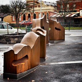
Artwork, other - Public Artwork, Cliff Burtt, Buninyong Bivium, 2016
Buninyong Bivium (2016) by Cliff Burtt engages with the geography and history of the Buninyong region in both pre and post settlement. The town of Buninyong is dominated by the profiles of Mt Helen and the extinct volcano Mt. Buninyong. Traditional land of the Wadawurrung people, today the area remains a significant site for the culture of indigenous people and their connection to the land. The profile of this sculpture is based on topographical mapping of the area, depicting sections of the landscape. The gaps between the elements of the work can be viewed as representations of the shafts sunk into the earth by the early gold miners and compound curves on the upper surfaces are mirroring the topography of the area, while cut-aways in the sides are suggestive of rock strata.The artwork is of aesthetic and social significance to the people of BallaratCorten steel sculpture made of five unique sculptural pieces secured to at concreate base at pavement levelbuninyong, cliff burtt, sculpture, public art, mining, ballarat -
 Mordialloc College Alumni Association Inc (MCAA)
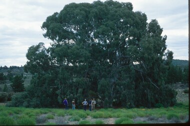
Photograph, 1979 Wyperfeld Old Be-al River Red Gum Tree, 1979
1979 - Mordialloc-Chelsea High School students standing in front of “Old Be-al” in Victoria’s Wyperfeld National Park, near Outlet Creek. It has been described as one of the most magnificent River Red Gums in the land. This glorious tree with foliage hanging to the ground escaped the fire of 1959 but not the fire of 1982 that damaged it badly. It lives on but has also suffered from lack of water and is now inaccessible to the public in a reference area. The MCAA has provided this image to the Friends of Wyperfeld National Park. Mordialloc-Chelsea High School students visited the Wyperfeld National park annually for the biology and geography Year 11 school camp.Example of a River Red Gum at Wyperfeld National Park.Digital image reproduced from colour slide.big desert fire 1959, mordialloc-chelsea high school camp, wyperfeld national park, fire 1982, old be-al river red gum -
 Queenscliffe Maritime Museum
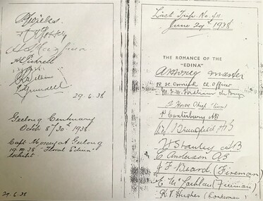
Document - copy of extract
Title: The romance of the "Edina" : the world's oldest screw-steamship : with chapters on the auxiliary steamship :Great Britain", and the Port Phillip Bay steamers past and present / by C. Dickson Gregory Author: Gregory, C. Dickson (Charles Dickson) Publication Information: Melbourne : Robertson & Mullens, 1935 Physical Description: xii, 84 p., [24] p. of plates : ill. ; 23 cm Series Link: Queenscliffe Maritime Museum General Note: Item no. Corporate Subject: Edina (Ship) Great Britain (Ship) Subject Term: Shipping -- Victoria Geographic Term: Port Phillip Bay Region (Vic.) -- History Format: Books Holds: 0 Copies: 2This iron hull single screw steamer had a long and distinguished carrier operating between 1853 and 1938. She served in the Crimean war carrying stores and horses to the Black Sea and later trading in the Mediterranean, and carrying cotton for the Confederate States in the American Civil War. Edina arrived in Melbourne under sail in March 1863 and was purchased by Stephen Henty for use from ports in western Victoria and later carried gold prospectors across the Tasman to New Zealand. After a refit in 1870 she was used in the coastal trade along the Queensland coast for Howard Smith until returning to Victoria and the Melbourne-Geelong trade as a cargo-passenger vessel. The Edina had two narrow escapes from destruction in 1898 and 1899 when she collided with other steamers, both being sunk. A further refit in 1917 altered her appearance with a new mast, funnel, bridge and promenade deck. By 1924 Edina had made over 12,000 Melbourne-Geelong passages and carried over one million people on the service. A further collision in July 1931 which sank the tug Hovell forced Edina onto a mudbank on Port Phillip Bay. She was taken out of service in 1938 but was later renamed Dinah and used as a lighter until 1958 when she was broken up and her remains used as land-fill.Extract from the book 'The Romance of the Edina' showing signatures of her last voyage crew in 1938.'The Romance of the Edina'ss edina, port phillip, steam ships -
 Bendigo Historical Society Inc.
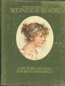
Book - WARD LOCK & CO'S WONDER BOOK, 1906
Hard cover picture annual for boys and girls published by Ward Lock & Co Ltd London New York and Melbourne, edited by Harry Golding. A book of childrens stories with green cover showing a portrait of a young girl, title in gold lettering surrounded with black decorative design, contains black and white plus some colour illustrations. Inscription inside front cover reads, Xmas examination 1906 prize awarded to Miss Ralla Mitchell for dux of third class 1st in arithmetic, reading, grammar, geography & spelling U V.Obrien Principal ''Vinery'' Myers St & View St private schools.books, children's, picture annual -
 Bendigo Historical Society Inc.
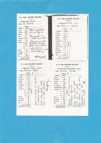
Document - GOLDEN SQUARE LAUREL STREET P.S. COLLECTION: EXAMINATION CARDS
Four white photocopy examination cards laminated upon blue cardboard and printed, SS 1189 , Golden Square, years 1941-42. Each outlines numbered marks out of ten for student named Elaine Rudd for subjects, Reading, Recitation, Spelling, Writing, Composition, English, Arithmetic A-B-C-D, History, Geography, Handwork, Art. B Rutherford and F Baggaley signatures. Written note states, 'Position; 3rd in class of 45. Excellent result. Elaine has done good work all the year. She seems to be very interested in her school work. Initialled FB.bendigo, institutions, golden square primary school -
 Mont De Lancey
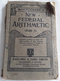
Book, Whitcombe and Tombs Limited, Whitcombe's New Federal Arithmetic Grade VI, 1937
An arithmetic book for Grade VI elementary students with exercises, problems, diagrams and revision for young students in Australia.A badly damaged grey softcover textbook with the title, Whitcombe's New Federal Arithmetic Grade VI printed on a black lined scroll design with Specially written to meet the requirements of the Revised Victorian Course of Study in Elementary School in a box at the bottom along with the publisher symbol. Whitcombe & Tombs Limited Melbourne & Sydney and other cities is printed beneath. The price 1/3 is written in the right hand bottom corner. Inside are exercises, short problems, diagrams and lists of examples of work set out for the students. There are pencil and ink markings inside. On the back inside and outside the cover are advertisements for Whitcombe's Vivid History and Geography Readers. 132p. non-fictionAn arithmetic book for Grade VI elementary students with exercises, problems, diagrams and revision for young students in Australia.arithmetic, school curriculum, australian schools -
 Stawell Historical Society Inc
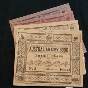
Booklet, Education Department, Australian Copy book
Books used in teaching writing0682-6: Fawn cardboard cover, with complex border artwork. 0682-7: Blue cardboard cover, with complex border artwork. 0682-8: Pink cardboard cover, with complex border artwork. 0682-6: S. Australia. Victoria. N.S. Wales. Queensland. Australian Copy Book Third Class. Medium Hand. Proverbs. Geographical Definitions. Arithmetic. No. 3 Price 2d. W. Australia Tasmania. New Zealand. Melbourne: Published for the Education Department by J. Kemp. Government Printer. 0682-7: Christina (Handwritten) S. Australia. Victoria. N.S. Wales. Queensland. Australian Copy Book Fourth Class. Small Hand. Proverbs. Geography. Commercial Terms. No.4 Price 2d. W. Australia Tasmania. New Zealand. Melbourne: Published for the Education Department by J. Kemp. Government Printer. 0682-8: Angus Cumming (Handwritten) S. Australia. Victoria. N.S. Wales. Queensland. Australian Copy Book Fifth and Sixth Class. Quotations, Poetry & Prose. Commercial. Letters & Forms. No.5 Price 2d. W. Australia Tasmania. New Zealand. Melbourne: Published for the Education Department by J. Kemp. Government Printer.stawell education -
 Phillip Island and District Historical Society Inc.
Photograph
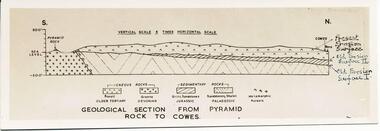
One of a collection of over 400 photographs in an album commenced in 1960 and presented to the Phillip Island & Westernport Historical Society by the Shire of Phillip IslandPhotograph of a sketch of the geological section from Pyramid Rock to Cowes - drawn by Dr G Baker, CSIRO, University of Melbourne.Geological section from Pyramid Rock to Coweslocal history, photography, geological section across phillip island, black & white photograph, geography, topography, cowes, pyramid rock, sketches, dr g baker, john jenner, bryant west -
 Orbost & District Historical Society
black and white photograph, 1962
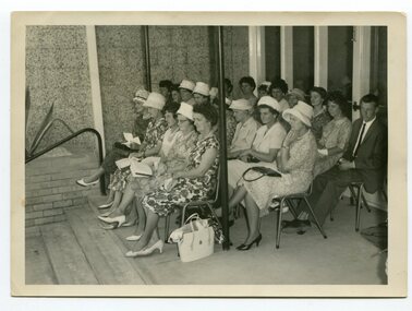
In 2012, Orbost Secondary College and the wider community celebrated 100 years of secondary education in Orbost. With earlier levels of schooling available at the Orbost State School or nearby schools of Newmerella and Jarrahmond School, it was not until April 1912, and after much campaigning from parents and other notable community members, that the Orbost Higher Elementary School was opened. Mr Richard Trembath was appointed the new Head teacher of Orbost Higher Elementary School and was assisted by Miss Olga Hirst. The senior class consisted of 26 pupils, and the junior class, 16 pupils. A limited curriculum was available which included lessons in Latin, Arithmetic, Algebra, Geometry, Geography, History, Drawing and advanced English. (info. O.S.C. website)Orbost High School / Orbost Secondary College has played a significant part in the education of senior students in the Orbost district . It is the sole senior educational institution. A black / white photograph of a group of ladies seated on chairs outside the Orbost High School.on back - hand-written - " Orbost H.s. Jubilee, 1962 - Welfare Ladies & Edna Towns, Joan Liddell" -
 Bendigo Historical Society Inc.
Slide - Bendigo College of Advanced Education - Landscaping, about 1986
Bendigo TAFE is a regional provider of vocational education, training and assessment services, located in northern and central Victoria, Australia. The institute has been in operation in various guises since 1854. The institute was known as the Loddon Campaspe Institute of TAFE from 1987 to 1990, Bendigo Regional Institute of TAFE (BRIT) from 1990 to 2009, before becoming Bendigo TAFE in 2009. Bendigo TAFE services a significant geographical area of approximately 25,000 square kilometres in central and northern Victoria, with a local population of 220,000. In May 2014, Bendigo TAFE announced that it would merge with the Melbourne-based Kangan Institute to form Bendigo Kangan Institute, however both institutes retain their existing branding.Bendigo College of Advanced Education (BCAE) early years - 24 slides of Landscaping at the new premises in Nolan Street Bendigo (Now the Bendigo Tertiary and Further Education (TAFE). history, bendigo, bendigo college of advanced education, bcae, landscaping, bendigo tafe -
 University of Melbourne, Burnley Campus Archives
Album - Glass slides, W. H. Cooper, Glass Lantern Slides Full Collection, 1900s-1950s
Sandra Pullman visited the Melbourne City Council Exhibition, 'Melbourne Parks and Gardens Through the Magic Lantern' in November 2012. Lex Nieboer, former Burnley student graduating in 1975, found a large number of glass lantern slides in a store room and took them home as he was concerned they would be thrown out. His family has a long tradition of being involved in photography, so he understood the value of the slides. He donated the ones that were of Melbourne City Parks and Gardens to the Council and they used them in their exhibition. Sandra contacted Lex and arranged with Jane Wilson (Archivist) to visit Lex on 12 April, 2013 at Wilson Botanic Park, Berwick where he works. After Lex showed them the slides, he, very generously, donated approximately 300 slides back to the Burnley Archives. There was already a collection of almost 100 glass slides in the Archives. They were in a wooden box containing glass lantern slides with label on outside, "Slides of Horticultural Objects and Views." Inside lid is handwritten, "Mr Bailey Botanic Gardens Adelaide." (John Frederick Bailey, Director Adelaide Botanic Gardens 1917-1932.) and, "Mr Isaac 9 pla? 2 ficifolia." (Probably Mr Isaacs Mayor of Adelaide 1917.) Also, "Purchased from Estate of Reeves Late Malvern Gardens, AWJ." (F.L. Reeves, Malvern Council's Park Curator in the 1920's died in 1933. AWJ, A.W. Jessep, Principal Burnley Horticultural College 1926-1941.) These were numbers 61-85 "History of the Rose." Geoff Olive, former Staff member, remembered taking a number of glass slides to a photographic processor to have 35mm slides made from them. 60 of these are also in this collection. Also see B10.0057 for Melbourne City Council collection and, 11.0039, 12.0033 for photograph prints of lantern slides lost to the collection.Collection of approximately 400 glass lantern slides used for teaching at Burnley Horticultural College during the first half of the twentieth century. Some were made specifically for Burnley. Some images would not upload. The images include: overseas views of gardens, historical sites and geographical features (some hand coloured from Japan); a series of hand coloured images of roses with notes for teaching the history of the rose; school gardens of the early 1900's; fruit and vegetables; miscellaneous horticulltural; Australian native plants; cells; 'Living Races'; plants, trees and grasses; parasites, organisms and fungal diseases; miscellaneous horticultural scenes; parks; cattle; agricultural data.sandra pullman, lex nieboer, melbourne city council exhibition through the magic lantern, john frederick bailey, mr isaacs, f l reeves, a w jessep, history of the rose, plants, trees, diseases -
 Nillumbik Shire Council
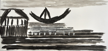
Drawing: Tim RYAN, Tim Ryan, Queenscliff 1,2 and 3, 2012
“Queenscliff (three black and white boat/ship themed set), is a depiction of a trio of sailing vessels, and a typical example of Tim Ryan’s process and style / It illustrates three images from separate editions of National Geographic – a much-loved and constantly revisited source of inspiration / Tim has reduced his subject matter to minimal line, managing to capture the form and character of the scene and the people within with delicacy and sensitivity / As is also a common trait, Tim has discarded the idea of a using a title describing the actual scenes in favour of one that holds much greater personal significance / Queenscliff is the site of his family holiday home, hence a place evoking decades of memories connected with water, horizon and water-based activity and interaction.Tim Ryan has worked within the Studio Art Program at Araluen for almost a decade / Araluen is based in the north eastern suburbs of Melbourne (Nillumbik region), that provides accommodation and day services for adults with an intellectual disability / Creating and sharing artwork is one way Araluen participants express their thoughts, personalities and abilities. The art program allows them to develop a sense of achievement and access society as equal and valued participants / Tim puts a great deal of effort into selecting his subject and arranging his page / He immerses himself in the image, studying it thoroughly and sometimes tracing over it with his finger before commencing / He focuses on the different elements and relationships that inspire, bringing out the lines, colours and shapes most fitted for translation into the picture / Favourite references are photo-laden books and magazines covering topics as broad as nature, history, archaeology, exotic foreign lands and all forms of transport.Three black and white drawings of boats/ships in Queenscliff made using watercolor, ink, fine liner, pencil and acrylic on paper. All drawings are black and white in colour with one drawing rendering a boat in warm red/orange and yellow colours. None shown, catalogue label on backdrawings / black & white / ink / boats / ships / queenscliff / araluen / ryan / disability -
 Bendigo Historical Society Inc.
Map - GREAT EXTENDED HUSTLER'S MINE - TRANSVERSE SECTION OF THE GREAT EXTENDED HUSTLER'S MINE
Transverse Section of the Great Extended Hustler's Mine on the Hustler's Line of Reef. Bulletin No 33, Plate No XII. Shows Poppet legs at the surface and Sill of Shaft at 788.99 feet above Sea Level, Cross Cuts and their depths, stone and geographical features encountered and their references and a number of enlarged drawing of sections of the crosscuts, Geological Survey of Victoria emblem and signed by H A Whitelaw, Underground Survey Office Bendigo, September 1913. The depths of crosscuts to No 21 were taken from plans of surveys by Mr. Walker and Mr. Craven, noted under Reference. Another note: This Saddle Reef is sketched from Mr. Walker's plan. Dividends amounting to 360,000 pounds were obtained from it. mining, parish map, great extended hustler's mine, transverse section of the great extended hustler's mine, old shaft, mr walker, mr craven, geological survey of victoria, underground survey office bendigo, h a whitelaw -
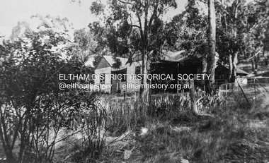 Eltham District Historical Society Inc
Photograph - Digital copy of photograph, Former Griffith family home, Banoon Road, Eltham, c.1955
Former family home of Mr. Frederick Eldred (Fred) Griffith in the 1950s, where present day Griffith Park is situated on the Yarra River at Eltham. Fred Griffith was also a Councillor (1945, 1951-1953) and former Shire President (1951) of the Shire of Eltham. Faye Walker (nee Harris) spent her first ten years living in the house. She recalls "there was a huge tin shed to the rear but toward the east of the house. I assume this is what people were thinking of when reference was made to the ‘’packing shed’. When I was small in the 50s, the shed was no longer being used for fruit packing but by the Griffith family as storage. Many of the pear trees remained but were no longer a commercial venture. We used to sneak up to the shed to read the National Geographic Magazines."griffith park, eltham, frederick eldred griffith, faye walker (nee harris) collection -
 Bendigo Military Museum
Photograph - Orthophotomap Workstation, Lithographic Squadron – Army Survey Regiment, Fortuna, Bendigo, 1988
This collection of four photos was most likely taken at Lithographic Squadron, Army Survey Regiment, Fortuna, Bendigo in 1988. Orthophoto mapping provided the Survey Corps with the capability to produce map products quickly in the event of a crisis. These are four photographs of equipment used by the Army Survey Regiment to produce orthophotomaps. The OR1 orthophoto projector and workstation was introduced in the mid-1980s. It was the second-generation equipment used to orthorectify colour and monochrome film aerial photography, replacing the system introduced in 1973. Orthorectification is the process of removing geometric distortions and scale errors/variations from images. Images have tilt and relief distortions that make it difficult to compare accurately a map and an image of the same geographic area. Once an image is orthorectified, features on the image are shown in their planimetric locations. These four photographs of orthorectification equipment in operation were taken at the Army Survey Regiment at Fortuna, Bendigo, 1988. The photographs were on 35mm negative film and were scanned at 96 dpi. They are part of the Army Survey Regiment’s Collection. .1) to .4) - Photo, black & white, 1988, WILD OR-1 Orthorectification Workstation, SPR Carmel (Butler) Fauth.No personnel are identifiedroyal australian survey corps, rasvy, army survey regiment, army svy regt, fortuna, asr, litho -
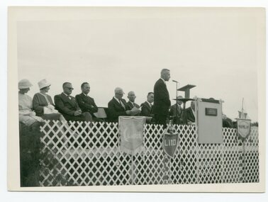
 Orbost & District Historical Society
black and white photograph, 1962
This photo shows Bert May addressing a group of ladiers at the 1962 Golden Jubilee of the Orbost High School. Bert May served as the Member for Gippsland in the Legislative Council from 1957 until 1973. With earlier levels of schooling available at the Orbost State School or nearby schools of Newmerella and Jarrahmond School, it was not until April 1912, and after much campaigning from parents and other notable community members, that the Orbost Higher Elementary School was opened. Mr Richard Trembath was appointed the new Head teacher of Orbost Higher Elementary School and was assisted by Miss Olga Hirst. The senior class consisted of 26 pupils, and the junior class, 16 pupils. A limited curriculum was available which included lessons in Latin, Arithmetic, Algebra, Geometry, Geography, History, Drawing and advanced English. (ref. O.S.C. website)Orbost High School / Orbost Secondary College has played a significant part in the education of senior students in the Orbost district . It is the sole senior educational institution. This item is representative of its history and is a useful reference tool.A black / white photograph of a man giving a speech to a group of ladies in a classroom. all are standing.on back - Bert May, Orbost H.S. Jubilee 1962orbost-education orbost-high-school -
 Orbost & District Historical Society
black and white photograph, 1962
This photograph was taken at the Golden Jubilee of Orbost High School in 1962. Bert May is addressing crowds. Bert May served as the Member for Gippsland in the Legislative Council from 1957 until 1973. With earlier levels of schooling available at the Orbost State School or nearby schools of Newmerella and Jarrahmond School, it was not until April 1912, and after much campaigning from parents and other notable community members, that the Orbost Higher Elementary School was opened. Mr Richard Trembath was appointed the new Head teacher of Orbost Higher Elementary School and was assisted by Miss Olga Hirst. The senior class consisted of 26 pupils, and the junior class, 16 pupils. A limited curriculum was available which included lessons in Latin, Arithmetic, Algebra, Geometry, Geography, History, Drawing and advanced English. (info. from O.S.C. website.Orbost High School / Orbost Secondary College has played a significant part in the education of senior students in the Orbost district . It is the sole senior educational institution. A black / white photograph of Mr Bert May, on a stage, addressing an audience, most seated, some standing behind him.back - hand-written - "Orbost H.S. Jubilee, 1962 - Bert May".orbost -education orbost-high-school -
 Kew Historical Society Inc
Archive (Series) - Subject File, Kew Historical Society, Histories of Kew, 1958
Various partiesReference, Research, InformationSecondary Values (KHS Imposed Order)Subject file containing short general histories of Kew, or geographic parts thereof, and timelines compiled by various individuals, some of who were members of the Kew Historical Society. Authors of content include Isaac Selby, Dorothy Rogers, Dione McIntyre and Graeme Lindsay. Other authors are not identified. Some of these histories were used on annual bus trips of the suburb during the Kew Festival. Notes on specific aspects of Kew’s history relate to early exploration, settlement in Cotham Road, the influence of the environment, northern and eastern Kew and Studley Park. The majority of these monographs remain unpublished texts. The file also contains summaries and or transcripts of talks given to the Society by Geoff Clarke (1975) and Allan Wakefield about their recollections of Kew’s history.kew (vic) - history, kew - early landowners, kew - environmental history, geoff clarke, allan wakefield, kew historical society - members, kew historical society - researchkew (vic) - history, kew - early landowners, kew - environmental history, geoff clarke, allan wakefield, kew historical society - members, kew historical society - research -
 Bendigo Historical Society Inc.
Map - GREAT EXTENDED HUSTLER'S MINE - LONGITUDINAL SECTION OF THE GREAT EXTENDED HUSTLER'S MINE
Longitudinal Section of the Great Extended Hustler's Mine on the Hustler's Line of Reefs. Bulletin No 33, Plate No XIII. Map shows the Hustler's Tribute, 2 Old Shafts, Great Extended Hustler's Shaft, Latham & Watson's Shaft and Ironbark Gully. Datum Line 750 feet above Sea Level. Poppet Legs on the surface and Sill of Shaft 788.99 feet above Sea Level. Levels and their depths are shown and some geographical features. Some amounts of gold mined mentioned. Geological Survey of Victoria emblem and signed by H A Whitelaw, Underground Survey Office Bendigo, September 1913. Note - Plates 4, 8, 13,20, 26 & 31 form a Longitudinal Section from Fortuna Hustlers to Hustler's Consols Mine. mining, parish map, great extended hustler's mine, geological survey of victoria, underground survey office bendigo, h a whitelaw, hustler's tribute, old shaft, great extended hustler's shaft, latham & watson's shaft, ironbark gully -
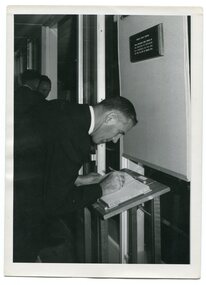 Orbost & District Historical Society
black and white photograph, 1962
This is a photograph of Bruce Evans, Member of the Victorian Legislative Assembly, signing the visitors' book at the Orbost High School Golden Jubilee in 1962. In 2012, Orbost Secondary College and the wider community celebrated 100 years of secondary education in Orbost. With earlier levels of schooling available at the Orbost State School or nearby schools of Newmerella and Jarrahmond School, it was not until April 1912, and after much campaigning from parents and other notable community members, that the Orbost Higher Elementary School was opened. Mr Richard Trembath was appointed the new Head teacher of Orbost Higher Elementary School and was assisted by Miss Olga Hirst. The senior class consisted of 26 pupils, and the junior class, 16 pupils. A limited curriculum was available which included lessons in Latin, Arithmetic, Algebra, Geometry, Geography, History, Drawing and advanced English. (inf0. from O.S.C. website)Orbost High School / Orbost Secondary College has played a significant part in the education of senior students in the Orbost district . It is the sole senior educational institution. A black / white photograph of a man in a suit signing a book.on back - hand-written -" Orbost H. S. Golden Jubilee 1962. Bruce Evans M.L.A. signing Visitors' Book>" -
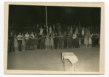 Orbost & District Historical Society
black and white photograph, March 1962
This photograph was taken at the Golden Jubilee celebrations of the Orbost High School in 1962. the group is singing "Old Lang Syne" after the celebratory dinner. There had been a cake on the small table at the front. With earlier levels of schooling available at the Orbost State School or nearby schools of Newmerella and Jarrahmond, it was not until April 1912, and after much campaigning from parents and other notable community members, that the Orbost Higher Elementary School was opened. Mr Richard Trembath was appointed the new Head teacher of Orbost Higher Elementary School and was assisted by Miss Olga Ernst. The senior class consisted of 26 pupils, and the junior class, 16 pupils. A limited curriculum was available which included lessons in Latin, Arithmetic, Algebra, Geometry, Geography, History, Drawing and advanced English. this school eventually became the Orbost High School.Orbost High School / Orbost Secondary College has played a significant part in the education of senior students in the Orbost district . It is the sole senior educational institution. This item is representative of its historyA black / white photograph of a large group of people with linked hands. The photograph has been taken at night. There is a table at the front covered with a tablecloth.education-orbost orbost-high-school celebration -
 Bendigo Historical Society Inc.
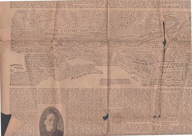
Newspaper - 1911 BENDIGO ADVERTISER, 14th July, 1914
( x ref 5673 , 8235 , Box 83 , 9077 ) Page 5 and 6 from the Bendigo Advertiser Friday July 14 1911. 1851 discovery of gold significant portion. Part of G Mackay 'Annals of Bendgo'Page 5 has an article titled Annals of Bendigo ''-the first article under this heading was published in the Bendigo Advertiser on 7th July .Included are Cameo photos of Messrs Johnson , Fenton , Sandbach , Frencham and Mrs Kennedy together with an early sketched map of the Bendigo Goldfields . Within the article is a mention of the sketched map as follows - '' The accompanying map was drawn from memory by W. Sandbach who lived a month in the Mia mia (22nd November to 19th December 1851 ) …The map was laid before the Frencham committee at the inquiry. The map shows geographical features such as 'Gentle Rise , Wooded pointbendigo, gold mining, bendigo discovery