Showing 1143 items
matching high country victoria
-
 Kiewa Valley Historical Society
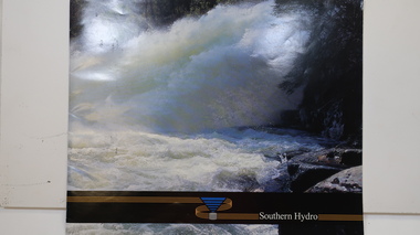
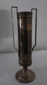
Booklet - Southern Hydro, Southern Hydro
Southern Hydro Ltd. was established in the late 1990s as a result of the disaggregation of the former State Electricity Commission of Victoria. It operates 10 power stations mainly in the north-east of VictoriaSouthern Hydro continued to encourage tourism as did the former State Electricity Commission of Victoria. This brochure is very similar to one previously published by the SECV "Victoria's Hydro Power" except only including those that it operates. Within the KHES the power stations were McKay Creek, Clover and West Kiewa. The change of ownership of hydro power from a government body to private enterprise in the late 1990s is of significant interest to the historian and consumer.Colored photo water spraying onto rocks with black strip across the bottom and logo (4 gold lines forming an "S", a blue triangle with grey cylinder beneath) of Southern Hydro within the strip. Back cover has a similar photo with 4 small photos of men inserted in the black column. This 23 page book gives a history of Southern Hydro and its 10 hydro-electric power stations that it operates. The book lists these and gives a description of each.Top right hand corner of page 5 has a piece of tape stuck over the print with "Page 11 to photo copy & enlarge" secv; khes; mckay creek power station; clover power station; west kiewa power station; mount beauty; rocky valley dam; -
 Kiewa Valley Historical Society
Leaflet - Kiewa, Welcome to Kiewa
The State Electricity Commission of Victoria constructed the Kiewa Hydro Electric Scheme from 1938 to 1961. The Scheme included three power stations, dams, tunnels and was becoming a popular tourist destination with Falls Creek Ski field within its boundaries.This leaflet was published by the SECV to ensure all visitors to the Kiewa Hydro Electric Scheme were made aware of safety measures with regard to their driving and to bush fires. These were necessary as the area was unique with driving on mountainous roads, changeable and extreme weather and the threat of bush fires. The gatehouse existed during construction, when the SECV was in charge, as a restriction to entry to the Scheme for SECV workers and those with permission to enter. The SECV controlled the area so in case of accident, the SECV was the body to contact not eg. the police.Small white and green leaflet made from one sheet of glossy paper and folded in half. Front cover has the title in the middle, the SECV emblem at the centre top and across the bottom is a message to read the inside pages which are safety messages for driving and bush fires. The back cover has a RACV road map of Kiewa and its 'works' including the Gatehouse which was the entrance to the scheme.The map also has an insert of the main roads & nearby cities. state electricity commission of victoria; kiewa hydro electric scheme; gatehouse; safety rules; kiewa -
 Kiewa Valley Historical Society
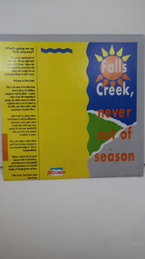
Brochure - Falls Creek Tourism, Falls Creek Never Out of Season
Falls Creek is a Ski Resort in the north east of Victoria. This brochure has been produced to encourage tourists to visit throughout the year.Tourism to the Kiewa Valley is an important industry for the area. Falls Creek is a ski resort with accommodation during winter for skiers, snow boarders and other snow sports. It involves entertainment, restaurants and associated workers. This brochure is produced to promote the resort throughout the year to increase the occupancy of these lodges. The tourist industry has increased steadily with fishing, cycling and bush walking increasing numbers in the area.Glossy square brochure folded in in half and half again. Front page is yellow on the left with black print on the far left. The right side has the title with blue, green and grey background with yellow, orange and white as part of the title. The back is a man standing in front of a sunset with print in a column towards the right side. Inside includes a map with advertisements for accommodation surrounding it.falls creek ski resort; alpine region in victoria; mountain lodges; -
 Kiewa Valley Historical Society
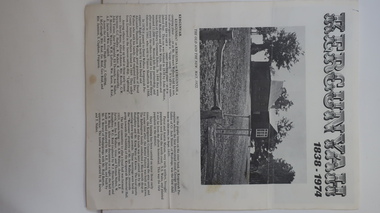
Leaflet - Kergunyah, Kergunyah 1838 - 1974, 1974
Kergunyah is a small town in the Kiewa Valley in north east Victoria. It is 10km south of Kiewa (town) and 23 km north of Dederang (town). it is farming country commencing in 1838, developing into a small community in 1974 with a School, Church, Post Office, Football Club, Young Farmer Club C.W.A. Netball Club, Card Club and Fire Brigade.Kergunyah is in the Kiewa Valley. Its history is important in the valley as it developed from a large pastoral run in 1838 into a small community supporting the local farming industry with essential organisations eg. school, fire brigade and social organisations eg. sporting teams, C.W.A.. Its history is significant as this leaflet has details of the organisations up to 1974 and this detail can be compared to organisations at Kergunyah today and can be compared to the history of other small rural communities. White stiff paper, folded to A4 size, with black and white photos on each of the 4 pages. Each page has detailed information under headings of community buildings and clubs in the small town. kergunyah; kiewa valley; small community; rural town; -
 Kiewa Valley Historical Society
Maps of Victoria
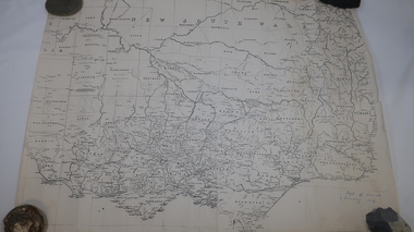
... Centre 31 Bogong High Plains Rd Mt Beauty high-country maps ...Three maps: copies from the 19th century. 1. Handwritten 'Dept of Lands & Survey 1876'. 2. Map of the Ovens & Murray District, Victoria with handwritten 'F.H. Hiscock & Co's, New Victoria Countries Atlas 1874'. 3. Map of the Murray and Gipps Land Distr' with handwritten: "Baillieu's County Atlas of Victoria 1866'.maps of victoria, 19th century, oven and murray district of victoria -
 Kiewa Valley Historical Society
Maps - Bogong x2, Tawonga, Omeo, Dargo, Victoria and others, 1. Bogong Alpine Area; 2. Bogong 8324; 3. Tawonga Topographical; 4. Omeo 8433; 5. Dargo 8323; 6. Victoria State
1. Bogong Alpine Area (outdoor Leisure Map. survey & Mapping Victoria, Government of Victoria, Edition 2, reprinted 1991 with an image of Mt. Feathertop on the front. Information for tourist in the Alpine National Park: Bogong Area. Including: recreational activities, history, weather and vegetation and a list of walks together with locality maps and photographs. The front cover has an image of Mt Feathertop against a blue sky with yellow writing 'Bogong Alpine Area', there is a yellow triangular block on the right hand top corner with black writing 'Outdoor Leisure Map. On the bottom edge is a block of yellow with black writing 'Survey & Mapping Victoria' and a light green map of Victoria with 'VICMSP' printed in white. 2. 8324 Bogong Victoria, Edition 1, Commonwealth of Australia 1981. A topographical Map: 1:100,000 scale (1 cm to 1 KM). Map has a red cover with white writing together with a white block and black writing and a map insert. 3. Tawonga Topographical Map - Forests Commission Victoria, / revised 5/9/77, DEG No. 68-G/399. A Tawonga 803 folded map in a beige colour with the back blank. 4. Omeo 8433 Victoria, Edition 1, Department of Natural Resources. The map has a red and white cover with black writing and a simple map of Australia at the bottom. 5. 8323 Dargo, Edition 1, Commonwealth of Australia. A red and white cover with a map insert. 6. Victoria State Map, Hema Maps, 2002. Hema Maps, State Map, colourful cover with a map of Australia and four tourism photographs. Scale 1: 850,000 An inscription handwritten in blue pen "Trappers Gap to Mitta Mitta 1" to 1 mile". There are some pen markings and notations of tracks.maps, bogong, omeo, tawonga, dargo, victoria, bogong alpine area -
 Kiewa Valley Historical Society
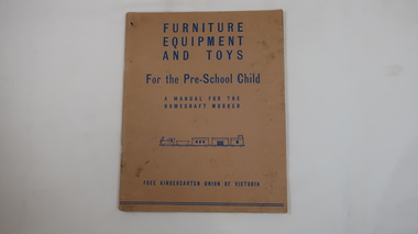
Book - Educational for Pre-School Child, Furniture, Equipment and Toys
Homemade toys were common in 1943.Mt Beauty's kindergarten had homemade toys.Faded cardboard cover with blue print on its front. 40 pages held by 2 staples on spine.'Furniture / Equipment / and Toys / For the Pre-School Child / A Manual for the / Homecraft worker / Picture of train / Free Kindergarten Union of Victoria' 1943mt beauty, kindergarten, toys, homemade equipment, pre-school -
 Kiewa Valley Historical Society
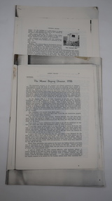
Papers - Mt Bogong (Two articles), Australian & New Zealand Ski Year Book: 1. Pages 91-94 and 2. Pages 45 -55
Mt Bogong is visited all year round. In 1936 Cleve Cole died after having been lost in a blizzard close to its summit. This resulted in the erection of snow poles and the Cleve Cole Hut.Mt Bogong, the highest mountain in Victoria, used by skiers in winter and bushwalkers in summer. The weather is variable.1. Article includes 'New Summit Hut' & includes effect of cattle on skiing conditions - 4 pages stapled top left corner 2. The Mt Bogong Disaster, 1936 Cleve Cole, Rescue. 10 pages stapled top left cornercleve cole, mt bogong, summit hut, snow, skiing disaster. -
 Kiewa Valley Historical Society
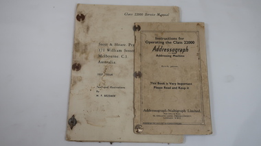
Books x2 - Addressograph, 1. Class 22000 Service Manual. 2. Instructions for Operating the Class 22000
The metal plate machine used plates that contained names, addresses and classifications of each State Electricity Commission of Victoria employee working on the Kiewa Hydro Electric Scheme. The plates were put through the machine onto pay envelopes. See also: KVHS 0848, KVHS 1046SECV employed many people on the KHES and used the latest technology of the time to pay each of them including each one with a pay slip.1. Thick yellowed paper. 21 pages typed one side only and 9 blank pages with 'Fig. 1' to 'Fig 12' typed. Fastened on the left side with 3 'document binders'. 1957 Issue 2. Cardboard cover with 40 pages of thick paper printed on both sides with black and white illustrations.1. Cover: Stott & Hoare. Pty Ltd. / 171 William St;, / Melbourne. C.1. / Australia / Text & Illustrations / By N.F. Vezener 2. Cover: Addressograph / Addressing Machine / Fourth Edition/ This Book is very Important / Please Read and Keep it / Addressograph - Multigraph Ltd. / Head Office & Works / 50 Oxgate Lane, Cricklewood / London. N.W. 2addressograph, secv, khes, pay slips -
 Kiewa Valley Historical Society
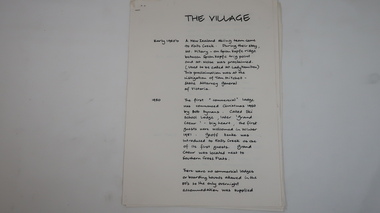
Papers - Falls Creek History, The Village
Timeline of Falls Creek during the 1950sFalls Creek is a snow resort on the Bogong High Plains, Victoria. The 1950s saw the village develop from its beginning to a popular ski resort.10 pages stapled top left corner. Includes a timeline of Falls Creek from early 1950s to the late 1950s. Titled 'The Village' and handwritten on one side only.falls creek, skiing, tourism, snow resort -
 Kiewa Valley Historical Society
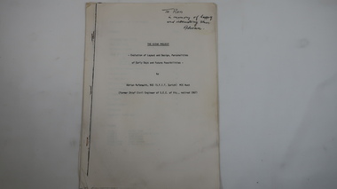
Memoir - Adrian Rufenacht, The Kiewa Project
Adrian Rufenacht, BCE (S.F.I.T. Zurich) MIE Aust. former Chief Civil Engineer of the State Electricity Commission of Victoria, retired 1967. Insight into the Kiewa Hydro Electric Scheme.First hand knowledge of the history of the Kewa Hydro Electric Scheme.40 pages stapled with 4 staples. The Kiewa Hydro Electric Scheme by Adrian Rufenacht, former civil engineer of SECV. Includes maps.On the front page - handwritten: 'To Ron / in memory of happy / and interesting times. / Adrianadrian rufenacht, khes, kiewa project, construction, secv -
 Kiewa Valley Historical Society
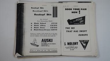
Papers - Skiing at Falls Creek
Skiing at Falls Creek from the 1940s has changed re - equipment, including eg. types of tows, gear and clothes. These pages give an insight into the 1960 and 1961 developments re accommodation, social scene, ads re equipment etc. and articles eg.on Tow-bar lifts, people, workers and tourists.Falls Creek, one of Victoria's most popular ski resorts, was developing quickly in the early 1960s. Photocopies of pages from 'Schuss' ski magazine 1960 and 1961 selected for the references to Falls Creek.falls creek, skiing, tourism -
 Kiewa Valley Historical Society
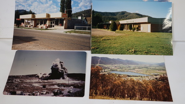
Photo Collection - Wally Howell, Falls Creek and Kiewa Hydro Electric Scheme including Mt Beauty
1. Falls Creek ski resort is on the Bogong High Plains 2. Kiewa Hydro Electric Scheme (late 1940s to early 1960s) was constructed by the State Electricity Commission of Victoria and included the townships of Bogong and Mt Beauty. The photos were taken by Wally Howell.Falls Creek is at the head of the Kiewa Valley and a major tourist attraction. Kiewa Hydro Electric Scheme was constructed by the SECV and included the creation of the Mt Beauty township.1. 16 Coloured photos of Falls Creek - not dated or labelled. Includes Malony's Ski Hire & Restaurant and Sundance Inn 2. 162 Coloured Photos not dated or labelled. Includes Kiewa Hydro Electric Scheme and Mt Beauty. Some multiple copies. 1. "Processed by Kodak Oct. 85 M" on printed in red ink on the back of one photo. Also, later labels were added in ink to identify each photo.falls creek, snow resort, skiing, ski lodges, sundance inn, malony's ski hire, spargos lodge, t-bar lifts, mt beauty, tourism -
 Kiewa Valley Historical Society
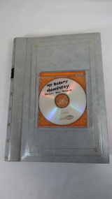
Photo Collection - Don Pollock, With DVD Mt Beauty Homestay
1. Photos cover features and events in the Kiewa Valley especially Mt Beauty. 2. Business 'Mt Beauty Homestay' 1990s to 2020 operated for 25 years iDon Pollock lived in the Kiewa Valley and ran a business for 25 years. Mt Beauty Homestays invited overseas students to live in their home, experience life in rural Victoria and to improve their English speaking skills. 1. Grey covered photo album holding 2 or 3 prints on each of 50 pages with clear vinyl pockets. The album is bound by a gold spiral ring. 2. DVD - Title 'Mt Beauty Homestay" on front cover and on the back 'Verbatim' on blue background. 1. First page only 'Ryder's Lane' 2. With title - Donor: Don Pollockkiewa valley, mt beauty homestays, don pollock, mt beauty -
 Kiewa Valley Historical Society
Trophy - Lieut. L.A. Heywood WWII and 58th Battalion
Lieut. L. A. Heywood was a Captain in 1945. The 58th Battalion was made up mostly of men from Victoria including Hume and was iniatially a militia unit before becoming part of the AIF in WWIIWWII and the connection of the 58th Battalion with local soldiers and possibly with L.A. HeywoodTall tarnished silver trophy with 'cup' base, small neck and long cylinder with a long straight handle on each side.On steel plate - inscribed "Presented by / Liut. L.A. Heywood / No 7 PL. 58th BN. / Awarded to / (blank)/ For best attendance / 1930 - 31" Under base: "Hecworth / E. P. (diamond shape) N.S."58th battalion, lieut. l.a. heywood -
 Kiewa Valley Historical Society
Papers - The Tobacco Industry
Tobacco in the Kiewa Valley. Tobacco was grown in Victoria for many years but the main areas (from the 1960s) included the Upper Kiewa River Valley where areas were suited. A Tobacco Research Station was established in Myrtleford, the geographical centre of the North Eastern tobacco growing area.Tobacco was grown successfully in the Kiewa Valley1. Leaflets x2 Green paper - 'The Tobacco Plant' Prepared by The Tobacco Growers of Victoira Limited in consultation with the Dept. of Agriculture Tobacco Research Station, Ovens. 1980s 2. papers yellowed and printed on both sides. - 'The Golden Leaf - The story of the tobacco leaf. Prepared by the Tobacco Growers of Victoria Ltd.' 1980stobacco, kiewa valley, agricultural farming -
 Kiewa Valley Historical Society
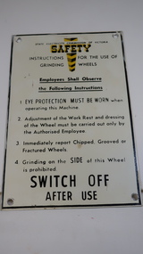
Sign - SECV, Safety - Grinding Wheels
The State Electricity Commission of Victoria produced and displayed safety signs for their employees during the construction of the Kiewa Hydro Electric Scheme.KHES was constructed from the late 1940s to early 1960s and included the construction of Mt Beauty and Bogong townships. Safety was a concern for the SECV towards its workers. Metal black print on white background with yellow 'emphasis' at the top - 'Safety'. "Instructions for the use of / Grinding Wheels". There is a circular hole in each corner with a black frame around the perimeter.state electricity commission of victoria, kiewa hydro electric scheme, safety sign, grinding wheels -
 Kiewa Valley Historical Society
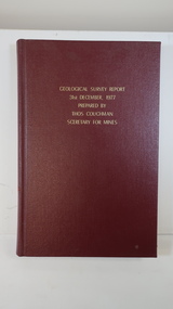
Book - Geographical Survey, Geographical Survey Report 31st Dec. 1977 prepared by Thos. Couchman Secretary for Mines
Office of Mines published progressive reports on the Geological Survey of parts of Victoria.This book includes a chapter on 'Dargo and Bogong' Pages 96 - 117 and includes a fold out map of this area. These pages show heavy use.Hard deep red cover with gold printed title located at the centre top. Bound with spine blank. 217 pages. Date 1878 First chapter and some pages have pencil marks including page 97.geological survey 1878, dargo, bogong -
 Kiewa Valley Historical Society
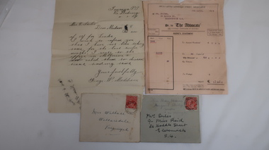
Letters x4 - Re Mrs Stiles
The Advocate was the Catholic newspaper of Victoria. The correspondence is in regard to payment and receipt of the newspapers.4 letters, 2 with envelopes. Chronological order: 1. 11 Jan 1927. From George W. Maddison, Tawonga P. O. Via Dederang to Mrs E. Stiles re money for 'Leader'. 2. 5th Apr. 1928. From Melbourne to Mrs Stiles, Melbourne re Account or "Advocate' 3. late July 1928. From Miss Mary Hessian, Mongans Bridge. Via Wodonga to Mrs Stiles re 'advocate' 4. 28th Jan. 1929 From Chas Martin to Mrs Wallace Bonnie Brae, Bruarong re Mrs Stiles papers. Envelopes: 1. (letter 3)Mrs Stiles c/- Miss Reid 26 Hoddle St. Elsternwick S-4 and in pencil Miss Mary Hessian, Mongan's Bridge, Huon via Wodonga 2. (letter 4) Mrs Wallace, Wallacedale, Kergunyah.mrs e. stiles, mary hessian, george w. maddison, mr wallace, 'advocate' newspaper, chas martin -
 Kiewa Valley Historical Society
Maps - Tawonga and Feathertop
Plan of Tawonga showing roads etc, rivers, use of land in 1968 and of Feathertop in 1969.Historical use of land in Tawonga and Feathertop.1. Topographical Map - Tawonga 803 Forests Commission of Victoria 1968. Cream paper with black print. Legend: Roads, tracks etc, rivers, Parishes and use of land. 2. Feathertop 813. 1969tawonga map 1968, tawonga parishes, feathertop map 1969 -
 Kiewa Valley Historical Society
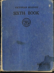
Book - English Reader, Victorian Readers Sixth Book, 1940
This book is a sixth grade reader which all Victorian students would have read during the 1940's. The book is made up of poems and stories, some which are still known and told today. Some pages have drawings that relate to the story of poems. This is historically significant due to showing what children read during the 1940's in schools across Victoria. Also it is a good comparison to what grade six children read now. Therefore it has good interpretation value and would be good in local school exhibitions. The names on the book indicate that this book came from a local famil, the Johnson and was read to two children of that family which gives this good social history. Some of the pages have had their pictured colored in by the student and words that have been underlined. These could have been harder words for the students to learn and seem advanced for grade six children to read. Book has a blue coverVICTORIAN READERS SIXTH BOOK, second edition, Victorian education stamp on front cover, SIXTH BOOK and EDUCATION DEPARTMENT VICTORIA ON SPIN. Inside cover has the names, Lorraine Margaret Johnson, Allan Johnson and Alice Payork? but that name has been crossed out and John with the son crossed out. All these names hand written in ink pen. book, school, reader, grade 6, department of education. children, stories, poems. -
 Kiewa Valley Historical Society
Postcard Circa 1950, Snow Plough, Bogong High Plain,5,500 Feet Kiewa Hydro-Electric Project, Circa 1950
This postcard was produced in the 1950's for the tourist trade in the Kiewa Valley and Alpine region. It encompasses the period when the State of Victoria was pressured by the ever increasing demand by industry and its population for electricity supplies. Hydro electricity was seen as an untapped natural resource to quench this demand. The Victorian Alps and the rivers flowing into its valleys was ideal for the construction of the Kiewa Hydro Electricity Scheme. The late 1940's saw the development of this scheme and the changing of sections of alpine landscape is covered by this and other postcards/pictures (tourists, construction workers, and established rural populations). This period in time was before the established wildlife and forest/nature groups became political activist who changed legislative acts to protect the environment. This rural region (Kiewa Valley/alpine plains) was at most only significant to a smaller group of winter sports, summer hikers/horse riders and rural farmers/graziers. The numbers of tourists and the increase in the local resident population was boosted by the construction of the Hydro Electricity Scheme. This influx to the regional population resulted in a corresponding diversity in services and brought about an environment that responded to a growing level of tourists and thereby permitting this industry to grow more rapidly than it would have naturally. This postcard details an attraction to the "cleaner" method of providing electricity. This postcard was purchased in 1950 by a surveyor at Landford's Gap. This item is a black and white photograph(professional) of a panoramic view of a snow plough clearing the unsealed road in 1950.This postcard is on quality paper and the reproduction of the picture is of a high standard.For other "tourist" postcards see 0480 (A) -(F) for other photos of similar postcards. kiewa valley tourism, victorian alps, alternate energy supplies, alpine population growth, secv, snow plough -
 Kiewa Valley Historical Society
Postcard Circa 1950, Road to Bogong High Plains Kiewa Hydro Electric Project, Circa 1950's
This postcard was produced in the 1950's for the tourist trade in the Kiewa Valley and Alpine region. It encompasses the period when the State of Victoria was pressured by the ever increasing demand by industry and its population for electricity supplies. Hydro electricity was seen as an untapped natural resource to quench this demand. The Victorian Alps and the rivers flowing into its valleys was ideal for the construction of the Kiewa Hydro Electricity Scheme. The late 1940's saw the development of this scheme and the changing of sections of alpine landscape is covered by this and other postcards/pictures (tourists, construction workers, and established rural populations). This period in time was before the established wildlife and forest/nature groups became political activist who changed legislative acts to protect the environment.This rural region (Kiewa Valley/alpine plains) was at most only significant to a smaller group of winter sports, summer hikers/horse riders and rural farmers/graziers. The numbers of tourists and the increase in the local resident population was boosted by the construction of the Hydro Electricity Scheme. This influx to the regional population resulted in a corresponding diversity in services and brought about an environment that responded to a growing level of tourists and thereby permitting this industry to grow more rapidly than it would have naturally. This postcard details an attraction to the "cleaner" method of providing electricity. This postcard was purchased in 1950 by a surveyor at Landford's Gap.This black and white photograph on a Valentine's postcard is from a V2 Argus photograph.. It is on a 200g/m paper density photo side gloss. See 0480 (A) - (G) for other photos of similar postcards.In white lettering " ROAD TO BOGONG HIGH PLAINS KIEWA HYDRO-ELECTRIC PROJECT", V3secv, road making, victorian alps -
 Kiewa Valley Historical Society
Postcard - Rocky Valley - Circa 1950, 1950
This postcard was produced in the 1950's for the tourist trade in the Kiewa Valley and Alpine region. It encompasses the period when the State of Victoria was pressured by the ever increasing demand by industry and its population for electricity supplies. Hydro electricity was seen as an untapped natural resource to quench this demand. The Victorian Alps and the rivers flowing into its valleys was ideal for the construction of the Kiewa Hydro Electricity Scheme. The late 1940's saw the development of this scheme and the changing of sections of alpine landscape is covered by this and other postcards/pictures (tourists, construction workers, and established rural populations). This period in time was before the established wildlife and forest/nature groups became political activist who changed legislative acts to protect the environment.This rural region (Kiewa Valley/alpine plains) was at most only significant to a smaller group of winter sports, summer hikers/horse riders and rural farmers/graziers. The numbers of tourists and the increase in the local resident population was boosted by the construction of the Hydro Electricity Scheme. This influx to the regional population resulted in a corresponding diversity in services and brought about an environment that responded to a growing level of tourists and thereby permitting this industry to grow more rapidly than it would have naturally. This postcard details an attraction to the "cleaner" method of providing electricity. This postcard was purchased in 1950 by a surveyor at Landford's Gap.This black and white photograph is from a Valentine's V2 Argus postcard. It is on a 200g/m paper density one side gloss. See also KVHS 0480 (A) to (L) for similar postcards. "ROCKY VALLEY FROM BOGONG HIGH PLAINS KIEWA HYDRO-ELECTRIC PROJECT" "V1"kiewa valley tourism, victorian alps, alternate energy supplies, alpine population growth, rocky valley, secv -
 Kiewa Valley Historical Society
Postcard - Junction Dam - Circa 1950, Circa 1950's
This postcard was produced in the 1950's for the tourist trade in the Kiewa Valley and Alpine region. It encompasses the period when the State of Victoria was pressured by the ever increasing demand by industry and its population for electricity supplies. Hydro electricity was seen as an untapped natural resource to quench this demand. The Victorian Alps and the rivers flowing into its valleys was ideal for the construction of the Kiewa Hydro Electricity Scheme. The late 1940's saw the development of this scheme and the changing of sections of alpine landscape is covered by this and other postcards/pictures (tourists, construction workers, and established rural populations). This period in time was before the established wildlife and forest/nature groups became political activist who changed legislative acts to protect the environment.This rural region (Kiewa Valley/alpine plains) was at most only significant to a smaller group of winter sports, summer hikers/horse riders and rural farmers/graziers. The numbers of tourists and the increase in the local resident population was boosted by the construction of the Hydro Electricity Scheme. This influx to the regional population resulted in a corresponding diversity in services and brought about an environment that responded to a growing level of tourists and thereby permitting this industry to grow more rapidly than it would have naturally. This postcard details an attraction to the "cleaner" method of providing electricity. This postcard was purchased in 1950 by a surveyor at Landford's Gap.This black and white photograph is a Valentine's postcard, from a V2 Argus photograph. It is on a 200g/m paper density with only the photo side gloss.Front "JUNCTION DAM & SPILLWAY, BOGONG KIEWA HYDRO-ELECTRIC PROJECT" on the flip side "VALENTINE'S POST CARD " "A GENUINE PHOTOGRAPH"kiewa valley tourism, victorian alps, alternate energy supplies, alpine population growth, junction dam, secv -
 Kiewa Valley Historical Society
Postcard - Junction Dam - Circa 1950, Circa 1950
This postcard was produced in the 1950's for the tourist trade in the Kiewa Valley and Alpine region. It encompasses the period when the State of Victoria was pressured by the ever increasing demand by industry and its population for electricity supplies. Hydro electricity was seen as an untapped natural resource to quench this demand. The Victorian Alps and the rivers flowing into its valleys was ideal for the construction of the Kiewa Hydro Electricity Scheme. The late 1940's saw the development of this scheme and the changing of sections of alpine landscape is covered by this and other postcards/pictures (tourists, construction workers, and established rural populations). This period in time was before the established wildlife and forest/nature groups became political activist who changed legislative acts to protect the environment.This rural region (Kiewa Valley/alpine plains) was at most only significant to a smaller group of winter sports, summer hikers/horse riders and rural farmers/graziers. The numbers of tourists and the increase in the local resident population was boosted by the construction of the Hydro Electricity Scheme. This influx to the regional population resulted in a corresponding diversity in services and brought about an environment that responded to a growing level of tourists and thereby permitting this industry to grow more rapidly than it would have naturally. This postcard details an attraction to the "cleaner" method of providing electricity. This postcard was purchased in 1950 by a surveyor at Landford's Gap.This black and white photograph on a Valentine's postcard is from a V2 Argus photograph. It is on a 200g/m paper density one side gloss only/. See 0480 (A) -(L) for other photos of similar postcards."JUNCTION DAM & SPILLWAY, LAKE GUY, BOGONG, KIEWA HYDRO-ELECTRIC PROJECT" "V5" on the flip side" VALENTINE'S POST CARD " "A GENUINE PHOTOGRAPH"kiewa valley tourism, victorian alps, alternate energy supplies, alpine population growth, junction dam, secv -
 Kiewa Valley Historical Society
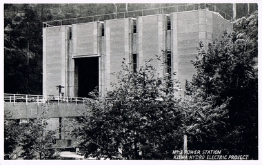
Postcard Circa 1950, No.3 Power Station Kiewa Hydro-electric Project "V.8", Circa 1950
This postcard was produced in the 1950's for the tourist trade in the Kiewa Valley and Alpine region. It encompasses the period when the State of Victoria was pressured by the ever increasing demand by industry and its population for electricity supplies. Hydro electricity was seen as an untapped natural resource to quench this demand. The Victorian Alps and the rivers flowing into its valleys was ideal for the construction of the Kiewa Hydro Electricity Scheme. The late 1940's saw the development of this scheme and the changing of sections of alpine landscape is covered by this and other postcards/pictures (tourists, construction workers, and established rural populations). This period in time was before the established wildlife and forest/nature groups became political activist who changed legislative acts to protect the environment.This rural region (Kiewa Valley/alpine plains) was at most only significant to a smaller group of winter sports, summer hikers/horse riders and rural farmers/graziers. The numbers of tourists and the increase in the local resident population was boosted by the construction of the Hydro Electricity Scheme. This influx to the regional population resulted in a corresponding diversity in services and brought about an environment that responded to a growing level of tourists and thereby permitting this industry to grow more rapidly than it would have naturally. This postcard details an attraction to the "cleaner" method of providing electricity. This postcard was purchased in 1950 by a surveyor at Landford's Gap.This black and white photograph from a Valentine's postcard is from a V2 Argus photograph postcard. It is on a 200g/m paper density photo side gloss. See 0480 (A) - (K) for other photos of similar postcards."No.3 POWER STATION KIEWA HYDRO ELECTRIC PROJECT" "V8"kiewa valley tourism, victorian alps, alternate energy supplies, alpine population growth, secv -
 Kiewa Valley Historical Society
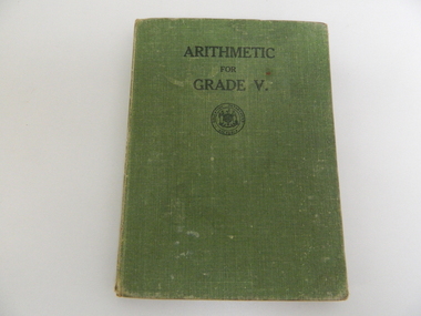
Book - Maths, Arithmetic for Grade V, 1943
This Arithmetic book was used by all Grade 5 students in the Victorian Government Schools during the 1940s. Each child owned oneHistorical: Represents all students of the time in Victoria and enables education to be compared with that of the present day. Green cloth covered - hard cover book.On cover, in black, ARITHMETIC / FOR / GRADE V. In circle an emblem in black and around this circle another with "Education Department Victoria" in black.education. victorian education. government education. school. arithmetic. mathematics. -
 Kiewa Valley Historical Society
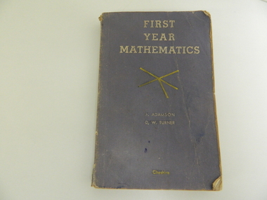
Book - Maths, F.W. Cheshire, First Year Mathematics, 1960
Educational Book used by students in Victoria for studying Mathematics. Davies are a local farming family attending school in the Kiewa Valley.Historical: Comparative study of Mathematics in different eras in Victoria. Provenance: The Davies family has been in the valley for generations.Faded purple cardboard cover with white writing and yellow lines In white: First / Year / Mathematics / 2 yellow lines at right angles crossing through centre with 1 added line coming to centre at an angle. / In white: P. Adamson / D. W. Turner / In yellow Cheshire Inside front cover 'Davies'education. mathematics. davies family. schools. -
 Kiewa Valley Historical Society
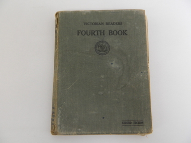
Book - English Reader, Victorian Readers Fourth Book, 1940
Educational book used by Allan Johnson in Grade 4 in a Victorian Government School.Historical: Comparative education for teaching reading in Grade 4 at Victorian Government Schools. Provenance: Allan Johnson's family and education at the Bogong Primary School which was known to have a good library.Grey book with cloth on cardboard cover.In black: Victorian Readers / Fourth Book / emblem in middle of circle surround by double circle inside which is printed Education department Victoria / Bottom righthand side with lines above and below Second Edition Allan Johnson written in ink on cover page.education. reading. schools. victorian education department