Showing 1102 items
matching information map
-
 Glenelg Shire Council Cultural Collection
Flyer - Flyer - Portland, Victoria, Oct-38
Single page flyer, folded 4 times. Tourist information for Portland, issued by Publicity and Tourist Services, Victorian Railways. Contains several black and white photos of Portland, front cover red print, blue stylised bird and sea. Back cover has tourist map of Portland and District -
Glenelg Shire Council Cultural Collection
Booklet - Brochure - Promoting Portland, Victoria, Victorian Railways Print, Oct-38
Brochure promoting Portland, folds out to A3 printed on light card. Front cover, white and blue stylised sky with sea and a seabird. 'PORTLAND, VICTORIA, AUSTRALIA' -printed in red. Back cover, black line map with roads marked in orange. Black and white photos of harbour, Dutton Beach, Gardens cottage, Henty Beach, 'Burswood', Henty Memorial, plus printed information about Portland and district.portland -
Glenelg Shire Council Cultural Collection
Pamphlet - Brochure - Glenelg River Canoeing Guide, Oct-88
Glenelg River canoeing guide, 4 pages, single-fold. Front and back pages information, photos and images of various areas of the Glenelg River; inside pages - detailed map of river and landings/camp sites. -
Glenelg Shire Council Cultural Collection
Flyer - Flyer - Historic Casterton, Victoria, n.d
... , white print, rest is white, blue print and maps and images..., blue print and maps and images, tourist information. Flyer ...DL flyer, bi-fold, Historic Casterton. Blue front page, white print, rest is white, blue print and maps and images, tourist information. -
Glenelg Shire Council Cultural Collection
Document - Portland and South West Tourist Guide, E. Davis & Sons, Pty Ltd Portland, n.d
Single page flyer, folded 3 times, printed both sides. White, black print, tourist guide to Portland and the far South West. Illustrations of Portland and district, maps of Portland, Heywood and Nelson, information about places to see. -
Glenelg Shire Council Cultural Collection
Map - Fold-out Tourist Map of Portland and District, n.d
Black and white fold-out map of Portland District. reverse has maps of Portland and Mt. Gambier, plus tourist information about points of interest in both towns. When folded, photo of Cape Nelson lighthouse on front. -
Glenelg Shire Council Cultural Collection
Flyer - Flyer - The Great Southern Touring Rout Adelaide to Melbourne, n.d
DL flyer, single sheet folded four times. 'The Great Southern' touring route, Adelaide to Melbourne, via Mt. Gambier & Geelong'. Contains map of touring route and information -
 Glenelg Shire Council Cultural Collection
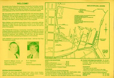
Programme - Programme - First Fleet Re-enactment Portland, Designed by Blue Wren Enterprises, P.O. Box 351, Portland, 3305, PORTLAND FIRST FLEET RE-ENACTMENT VISIT, March 1988
Double sided Brochure and programme of events for first fleet re-enactment at Portland, March 24 -28 1988. Yellow paper, green print. Illustration of 'Bounty' on front cover. On the back cover is a square bordered map of Port of Portland Victoria, a welcome blurb, extra entertainment, costs for boarding, and bookings information. Features headshots of Keith D. Wilson and R.F Harrison. first fleet, bounty, 1988, keith d wilson, r f harrison, port of portland -
Glenelg Shire Council Cultural Collection
Flyer, Portland Botanic Gardens, n.d
DL flyer, bi-fold, map of Portland Botanic Gardens, Portland City Coat of Arms, and view of Gardens Cottage on one side,. History of the gardens on the other. green paper, black print.tourism, visitor, advertising, local information -
Glenelg Shire Council Cultural Collection
Booklet, Commissioned by Portland Tourist Association Inc, 'Portland Victoria's Birth Place Welcome to Living History', n.d
Bowerbird MuseumPromotional booklet for Portland and District. Heavy paper covers, green with coloured photos of Portland and district. 44 page booklet, white with black print. Map of Portland and District in centre. Book contains information on Portland, plus National Parks, reacreation, business advertisments. -
Glenelg Shire Council Cultural Collection
Souvenir - Portland Tourist Information Kit, c. 1988
Identification numbers 7974 a - l Cream cardboard folder. Information kit: brochures / pamphlets/magazines about Portland and surrounds, compliments of Portland Tourist Assoc. Inc. Cover: red outline map of Australia with capital cities in red, and Portland by a blue dot, and 'Portland Victoria's Birthplace' and logo. Red print Portland Victoria's Birthplace above and below blue logo. 'Information kit with the compliments of ' in red print. (See other information)Front: White Portland Tourist Information Centre card stapled to inside of folderportland and surrounds -
 Greensborough Historical Society
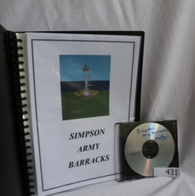
Folder and compact disc, Simpson Army Barracks, 2011_
This document is the result of research into the history of Watsonia Barracks (now Simpson Barracks) by GHS member Marilyn Smith. It details the origin of street names in the surrounding area and includes biographical information on those after whom the streets were named. Updated December 2016.The Watsonia Barracks has been in use since WW2 and is today home to the Defence Force School of Signals. It was built on the property formerly owned by Ainslie Meares. In 1951, surrounding land was purchased for the extension of the barracks. The suburb of Yallambie was formerly part of the Barracks. Black spiral bound folder (approx. 32 pages) with accompanying compact disc. Colour illustrations and maps. Updated 2016 in Word document.simpson army barracks, watsonia barracks, yallambie, marilyn smith, watsonia -
 Greensborough Historical Society
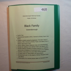
Folder, Black Family - Greensborough, 1900o
Contents: Family tree; small school books from family member; copy of map and advertisement for Watsonia Electric Station Estate; receipts; cemetery information; article on James Black and descendants; copies of un-named photos taken on Bundoora farm.The Black family owned a large portion of land from Greensborough to Watsonia. This collection is partly from family members.20-page plastic binder, green cover. Contains documents relating to the Black family of Greensborough and Watsonia.Collected by Greensborough Historical Society. Folder commenced 2012black family, shirley fraser, james black, watsonia electric station estate -
4th/19th Prince of Wales's Light Horse Regiment Unit History Room
Booklet, Manual of Map Reading, Air Photo Reading & Field Sketching Part 1 Map Reading 1955, 1955
Hard covered booklet for use of officer, NCOs and candidates for commission in the British Army and RAF explaining how to use a map and how to extract information from it. 4 copiesWO Code No 8868map reading -
 Kiewa Valley Historical Society
Photograph Farm Land, Mount Beauty Acreage before Golf Course, Circa 1950
This photograph is a "snap shot" in time circa 1950s detailing the rural environment before the effects of the Kiewa Valley Hydro Scheme altered the basic rural setting of the valley. The golfing fairway was being mapped out on previous grazing land, before the laying of a golf course, for use by the construction workers and auxiliary administration employees of the Victorian State Electricity Commission. This photograph details a dramatic period in time which saw an enormous change to the exclusively rural area of the Kiewa Valley region in the mid 1900s. This change presented both physical and mental challenges to the existing quiet rural inhabitants of the valley. The State of Victoria had to make adjustments to the changing demands imposed by population and industrial expansions. The development of cleaner energy supplies to a growing population has its downside ,which ever way the intrusion into the "natural" landscape is made.Black and white photograph detailing surveyor posts for construction of golf course. Land used, before establishment of the Mount Beauty Village, as farming/grazing cattle and viewed towards Mount Bogong and its Alpine ranges. The photo is on 200gms paper and not on photographic paper.nilmount beauty in the 1940s - 1950s, grazing in the kiewa valley, sec victoria -
 Kiewa Valley Historical Society
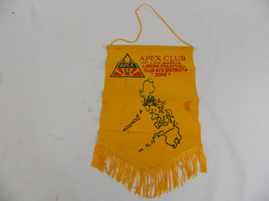
Banner & Pin - Apex Club
An Apex club existed in the Kiewa Valley. Apex clubs exchanged banners when a local member visited another club or when a member of another club visited the local club.Historical: Tas Davies belonged to the local Apex Club.Gold coloured flocked fabric banner with gold fringe at the bottom in triangular shape and cord on white plastic rod at the top. Gold coloured cord attached at each end of the rod to enable the banner to be hung. Apex gold pin attached - triangular logo on top of pin.Map of Philippines. Apex Club / of Los Banos / Laguna Philippines / Club 673.District 4 / Zone 7 Large red and green Apex logo. On pin: small red and green Apex logosocieties, clubs, community, service club, apex, banner, laguna, philippines, tas davies -
 Kiewa Valley Historical Society
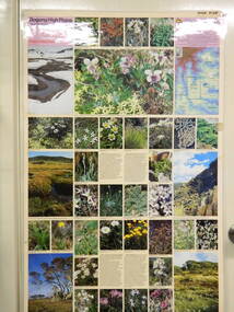
Map / Chart, Vegetation Map & Guide to Alpine Flora: Pretty Valley, 1982
This poster shows Pretty Valley is on the Victorian High Plains where the State Electricity Commission of Victoria worked on the Kiewa Hydro Scheme. Also cattle have grazed in the area over the years. This map is of interest to compare the flora in the area with times prior to 1982 and after 1982.This poster has historical and research value as it shows the flora in the pretty valley area therefore making it significant for people interested in plants. Also for those who would like to compare what plants are still in this area after 1982 and if the cattle grazing, climate change, of bush fires have had on the environment. Thus this poster also has good interpretive capacity of these reasons. Laminated double sided vegetation map and photographic guide to Alpine flora of the Pretty Valley areapretty valley. bogong. vegetation. plants. flowers. alpine. victorian high plains. cattle grazing. s.e.c.v. -
 Kiewa Valley Historical Society
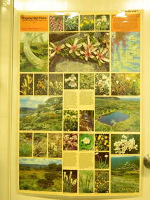
Map / Chart, Vegetation Map & Guide to Alpine Flora: Hotham, 1982
This poster shows Mt Hotham is on the Victorian High Plains. This poster and map enables the comparison to be made of flora in other areas of the Victorian High Plains e.g.. which was previously known as the Bogong High Plains. This poster has historical and research value as it shows the flora in Mt Hotham area therefore making it significant for people interested in plants. Also for those who would like to compare what plants are still in this area after 1982 and if the cattle grazing, climate change, of bush fires have had on the environment. Thus this poster also has good interpretive capacity of these reasons.Laminated double sided vegetation map and photographic guide to Alpine flora of the Hotham area.hotham. vegetation. plants. flowers. alpine. high plains of victoria. -
 Kiewa Valley Historical Society
Map / Chart, Vegetation Map & Guide to Alpine Flora: Rocky Valley, 1982
This poster is of Rocky Valley is on the Victorian High Plains where the State Electricity Commission of Victoria worked on the Kiewa Hydro Electric Scheme and also where cattlemen brought their cattle up during summer at various times. Its significance is due to it shows the flora of the area after the Kiewa Hydro Electric Scheme Rocky Valley damn has been build and therefore is a valuable for comparison to see what plants are there now after this information on this poster was complied. Historic: Comparison of the flora at Rocky Valley with other areas on the Victorian High Plains and with Rocky Valley before and after the Kiewa Hydro Scheme and / or grazing there. Is therefore research significance and interpretive capacity due to this compatibility value.Laminated double sided vegetation map and guide to the Alpine flora of the Rocky Valley area, with photographs of plants and vegetation.rocky valley. alpine. flora. vegetation. plants. s.e.c.v.. cattlemen. victorian high plains. -
 Kiewa Valley Historical Society
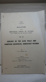
Document - Four Geological reports on the North-east Goldfields, Geological Survey of Victoria 1958 Bulletin
Geological Surveys of N.E. Goldfields Victoria included mines and tunnels. A resurvey of goldfields was necessary to re-assess economic possibilities using modern techniques and structural interpretation. It included an examination of a considerable surface area with maps and underground workings. Results were correlated and integrated and published by the Mines Department.The mines are in the Bogong Alpine Area.Foolscap printed Victorian Bulletins. Each stapled in the top left corner and each with varying number of pages. Covering 1941-1958 a) Glen Wills and Sunnyside b) Sunnyside Tunnel c) Red Robin d) Maud and Yellow Girl Government Printer, Mines Department, Melbourne, Victoriageology in the north-east, gold fields, goldmines, glen wills -
 Kiewa Valley Historical Society
Photos: Kiewa Hydro Electric Scheme x 12
K.H.E.S.Photos 4 coloured and 8 black and white with the Title printed below each one. 1. S.E.C.V. Telephone Switch Board (See also KVHS 0847) 2.West Kiewa Tunnel 3. Construction of Underground Power Station 4. Pretty Vally Camp 5.Outside Kiewa House, Bogong 6. S.E.C.V. Saucer (See also KVHS 0128) 7.Insulator Disk Struck by Lightning 8. S.E.C.V. Map of the Kiewa Hydro Scheme 9.Howman's Gap Camp 10.Tunnel Excavation Face 11. Mt Beauty Townhship 1948, looking north east 12. Mt Beauty Township - no labelkiewa hydro electric scheme photos -
 Kiewa Valley Historical Society
Maps - Bogong High Plains & Mt Beauty Township
The SECV continually updated their mapsDuring the development of the KHES the SECV had to continually update their mapsBoth Foolscap 1. Titled: High Plains Access Tracks & Roads 2. Mt Beauty Street Plan by SECV with Section Nos. and house numbersBoth have sticky tape marks on their back.khes maps -
 Kiewa Valley Historical Society
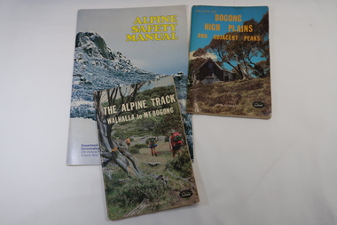
Books x3 - Walking on the Bogong High Plains, 1. The Alpine Track Walhalla to Mt Bogong. 2. Bogong High Plains and Adjacent Peaks both by John Siseman 3. Alpine Safety Manual
Books were published to guide walkers travelling long distances in remote areas increasing their safety and giving them independence.Bogong High Plains and Mt Bogong are at the upper end of the Kiewa Valley where local people and visitors spend their leisure time, walking.1. and 2. both written by John Siseman, small (pocket size), includes maps and black & white photos. The covers are colored photos with the title at the top. 1. has 78 pages and 2. has 63 pages.The Alpine Safety Manual (in yellow) is twice the size of the others and published by the Department of State Development, Decentralization and Tourism.It has 40 pages, coloured and black & white photos and is held by 2 staples.bush walking, bogong high plais, walhalla to mt bogong, alpine track -
 Kiewa Valley Historical Society
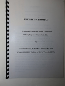
Booklet - The Kiewa Project, The Kiewa Project by Adrian Rufenacht
The Kiewa Hydro Electric Scheme was constructed by the SECVBooklet of 40 pages typed on both sides and including 4 maps at the back. It has a black plastic spiral spine and black back cover. Title on the front followed by 'Evolution of Layout and Design, Personalities / Of Early Days and Future Possibilities' followed by the authorkiewa hydro electric scheme, adrian rufenacht -
 Kiewa Valley Historical Society
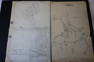
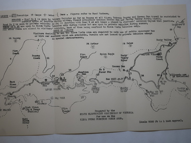
Map - Kiewa Hydro Electric Works Area
An early map of the Kiewa Hydro Electric Scheme Works Area prepared by the SECV for use when requesting access to the area. The regulations are printed regarding permits.During construction of the KHES there were restrictions on access to the area. This map identifies the land marks and states the regulations for entry to the area.Black and white map folded into three showing a legend with the townships, camps, gates and dams marked.Also indicating the roads, rivers, mountains and infrastructure of the KHES. khes works area, map of khes -
 Kiewa Valley Historical Society
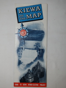
Map - Kiewa on the Map, Guide to Kiewa Hydro-Electric Project
Published by the SECV in 1950. They controlled the roads from Mt Beauty to the Bogong High Plains and all other roads within the Kiewa works area. The roads are not open to general tourist traffic. Conducted tours of the Kiewa area are operated by Eastern Road Lines Pty. Ltd., AlburyThe SECV constructed the KHES and controlled all roads within the Kiewa works area.Large colored map folded in half and then in 3. Front third is mostly blue and white with titles.. When opened the cover has black and white photos beside it with print and 'Please Note'. Also in the other half, a 'Road Map to Kiewa' showing the south eastern side of Australia, mostly yellow (the land) and blue (the sea). Inside the map is a close up map of "Ground Plan of Kiewa Hydro Electric Project' with a 'Key Map Showing Distances'.map of kiewa 1950, khes map -
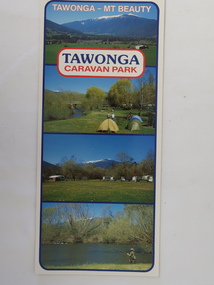 Kiewa Valley Historical Society
Brochure - Tawonga Caravan Park, Tawonga - Mt Beauty
Tawonga Caravan park is on the Kiewa River situated north of Mt Beauty and 30 km from Falls Creek. Tawonga Caravan park has always been popular for families and fishermen with plenty to do.Colored cardboard brochure with 3 small photos on the front and information printed on the back with a small map.tawonga caravan park, trout fishing -
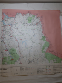 Kiewa Valley Historical Society
Map - Road Construction Authority 1986, Ref. Tallangatta 282008
Government authorities updated maps regularly.Historically of interest eg. 1. Pre dates the Alpine National Park. 2. 'Mt Beauty Estates' now known as Tawonga South. 3. Mt Niggerhead is named - It is now known as Mt Jaithmathang having been renamed in 2009.Colored map dated 1986 titled Road Construction Authority with an update of roads in the local Shires. It names places in the area and has a legion describing the rating of the roads and tracks. It also shows the main towns in the area and their roads.road construction authority, map of tallangatta area -
4th/19th Prince of Wales's Light Horse Regiment Unit History Room
Book, Government Press and Survey of Egypt, A Brief Record of the Advance of the Egyptian Expeditionary Force Under the Command of General Sir Edmund H H Allenby GCB, GCMB. July 1917 to October 1918, 1919
Provides historical information about operations of Australian Light Horse units in the Middle EastSoft covered A4 book, 112 pages plus mapsIn front cover: Joan Rice (Flawley) 41 Arnold Drive Chelsea vic 3196world war 1, middle east, egyptian expeditionary force -
 Kiewa Valley Historical Society
Maps - Educational x 10 and Kiewa Scheme x1
Maps were used to teach children geography, the explorers, the minerals, the world etc. The school bought and stored the maps so that they were available for use. This predated electronic devices. The KHE Works map was hand drawn showing lots of detail.These maps were used by the Bogong Primary School. The Kiewa Hydro Electric Works was built by the SECV and produced hydro power. This map may have been used by pupils as well as workers on the Works. Large coloured maps on canvas, with a wooden beam along the top and bottom. Each one has a cord attached to the top so that the map may be hung up on a wall. Some are made by Chas. H. Scally & Co., Baronia Ave., Wollstonecraft, N.S.W. The Kiewa Hydro Electric Works map is pinkish and shows Rocky Valley Dam, Lake Guy and Mt Beauty pondage in dark blue.maps, educational maps, geography, primary school, kiewa hydro electric works