Showing 991 items
matching map of the world
-
 Greensborough Historical Society
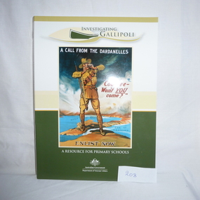
Book and CD, Australia. Department of Veterans Affairs, Investigating Gallipoli : a resource for secondary schools, 2010
Educational worksheets and activities used to teach children about Australia's role in the Gallipoli Campaign.Book: 80 p., illus. (some col.), maps, worksheets. Includes 2 discs: Disc 1 (video) Australians at War Episode 2; Disc 2 (DVD-ROM) Interactive activities and ABCs Gallipoli: the First Day website.australia department of veterans affairs, gallipoli, world war i, educational aids -
 Greensborough Historical Society
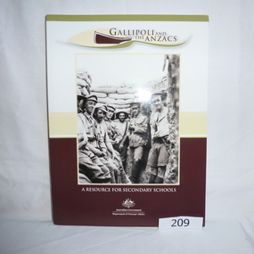
Book - Book and CD, Australia. Department of Veterans Affairs, Gallipoli and the ANZACS : a resource for secondary schools, 2010_
Educational worksheets and activities used to teach children about Australia's role in the Gallipoli Campaign.Book: 120 p., illus. (some col.), maps, worksheets. Includes 2 discs: Disc 1 (video) Australians at War Episode 2 and, Revealing Gallipoli; Disc 2 (DVD-ROM) Interactive activities and ABCs Gallipoli: the First Day website.australia department of veterans affairs, gallipoli, world war i, educational aids -
 4th/19th Prince of Wales's Light Horse Regiment Unit History Room
Documents, AFV School, Army Tank Wing, Army Tank Precis, Nov 1942
A soft covered, stapled, collection of précis issued in 1942 by Army Tank Wing of the AFV School, covering AFV characteristics, orders, map marking, crew training RT Procedure, flag & semaphore signals, battle procedures, working with other arms etc.afv training, world war 2 -
 Eltham District Historical Society Inc
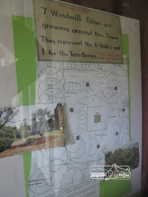
Photograph, Kangaroo Ground War Memorial Park: Photo display, 10 August 2016
Display in glass cabinet at the base of the stairs at the tower at Kangaroo Ground. 7 windmill palms are growing around the tower. They represent 6 states and 1 for the Territories with map and photo. As part of a program to acknowledge the Anzac Centenary Nillumbik Shire Council partnered with Yarra Plenty Regional Library to provide a bus tour with commentary of local sites of significance. These included Eltham township, the Shire of Eltham War Memorial at Kangaroo Ground, Christmas Hills, Hurstbridge memorial recreation park and finished at Eltham Library to view the Writing the War exhibtion at Eltham Library Community Gallery. Born Digitalworld war 1, war memorials, shire of nillumbik, heritage display, shire of eltham war memorial, kangaroo ground -
 4th/19th Prince of Wales's Light Horse Regiment Unit History Room
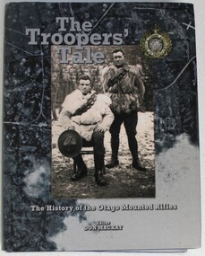
Book, Don Mackay, The Troopers' Tale - The History of the Otago Mounted Rifles, 2012
The Otago Mounted Rifles served in the Boer War. In World War 1 the Regiment fought at Gallipoli, then, later, on the Western Front they were part of 1 ANZAC Corps with elements of the 4th and 8th Australian Light Horse Regiments. Later the OMR was reorganised into II ANZAC Corps with B and D Squadrons of the 4th Australian light Horse. Featuring nearly 400 photographs, illustrations and maps. "The Troopers' Tale" records the history of the regiment from the 1860's to the present day, and tells the personal stories of many previously unknown New Zealand soldiers. Hard cover book. 382 pagesISBN 978-0-47320462-4book, otago mounted rifles, history, south african war, world war 1, book, otago mounted rifles, history, south african war, world war 1 -
 4th/19th Prince of Wales's Light Horse Regiment Unit History Room
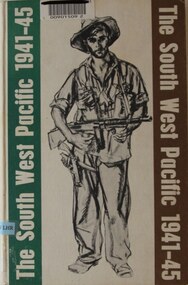
Book, Colonel E G Keogh M.B.E., E.D, The South West Pacific 1941-45, 1965
A book on war in New Guinea and Islands providing a detailed overview of Australian forces participation in the Battle for Australia. Concise for Kokoda and Milne Bay including copy of battle maps, but also covers Singapore, Borneo, Philippines, Wewak and Bougainville, and more.Hard covered book, 479 pages, WW11 Australian soldier on front cover bearing sub-machine gun and pistolnon-fictionA book on war in New Guinea and Islands providing a detailed overview of Australian forces participation in the Battle for Australia. Concise for Kokoda and Milne Bay including copy of battle maps, but also covers Singapore, Borneo, Philippines, Wewak and Bougainville, and more.history, world war 2, south west pacific, keogh -
4th/19th Prince of Wales's Light Horse Regiment Unit History Room
Book, Government Press and Survey of Egypt, A Brief Record of the Advance of the Egyptian Expeditionary Force Under the Command of General Sir Edmund H H Allenby GCB, GCMB. July 1917 to October 1918, 1919
Provides historical information about operations of Australian Light Horse units in the Middle EastSoft covered A4 book, 112 pages plus mapsIn front cover: Joan Rice (Flawley) 41 Arnold Drive Chelsea vic 3196world war 1, middle east, egyptian expeditionary force -
 Kiewa Valley Historical Society
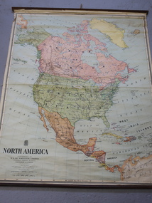
Maps - Educational x 10 and Kiewa Scheme x1
Maps were used to teach children geography, the explorers, the minerals, the world etc. The school bought and stored the maps so that they were available for use. This predated electronic devices. The KHE Works map was hand drawn showing lots of detail.These maps were used by the Bogong Primary School. The Kiewa Hydro Electric Works was built by the SECV and produced hydro power. This map may have been used by pupils as well as workers on the Works. Large coloured maps on canvas, with a wooden beam along the top and bottom. Each one has a cord attached to the top so that the map may be hung up on a wall. Some are made by Chas. H. Scally & Co., Baronia Ave., Wollstonecraft, N.S.W. The Kiewa Hydro Electric Works map is pinkish and shows Rocky Valley Dam, Lake Guy and Mt Beauty pondage in dark blue.maps, educational maps, geography, primary school, kiewa hydro electric works -
 Kiewa Valley Historical Society
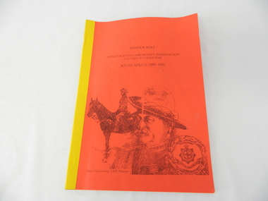
Book - Non Fiction History, Honour Roll - South Africa 1899 - 1902 Albury-Wodonga and District Residents Who Served In The Boer War, reprinted 03/2008
Historical information of soldiers from the Albury-Wodonga district who fought in the Boer War in South Africa 1899 - 1902. In 1996 the then curator for the 8/13 VMR Museum, the Hon Colonel John Neale, commissioned the author to research a group of returned servicemen and women from the Boer War and had lived within 100 km radius of the Albury/Wodonga townships.The Boer War was the second war in South Africa and was the result of heavy taxes and non voting rights of the local white Boer population. Colonial forces including the Australian Light Horse contingent where called upon by England to overthrow the rebellion. This War was the first engagement of Australian troops fighting on foreign soil.This Honour Roll details the pay rates, the battle highlights, weapons used and maps covering the first Australian contingent of soldiers who fought in the Transvaal (Boer War).. Listed are the names of those soldiers who lived within 100klms of Albury and Wodonga.The soldiers are listed by Location, Rank, Initial,Name and Unit. The significance of both the War and those who served in it is two fold. Firstly it demonstrates that the tie between the Colonial outreaches of England's Empire to "the Motherland" were extremely strong at this point in time. This union remained strong up until the middle of World War II when England could not help Australia to defend itself against possible invasion by Japan. The alliance between Australia and the United States of America replaced the British/Australian pact. Secondly the attitude of, and the high degree of horsemanship of those from the Albury and Wodonga area. The degree of adaptability, by these servicemen, to suit the environment in which they fought provided the first real insight into the Australian psyche "of those living and surviving on the harsh Australian outback"This book has a bright red soft cover and is bound with bright yellow tape. There is a drawing of two Australian soldiers on the front, one on horsebackAuthor's complimentary inscription "To Mount Beauty Museum with compliments" signed Ian R Docking history, boer war, ex-servicemen and women, albury and wodonga -
 Kiewa Valley Historical Society
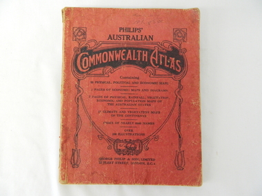
Atlas Australian Commonwealth, Philips' Australian Commonwealth Atlas, 1944
... details. The atlas contain 56 pages of world and Australian maps... details. The atlas contain 56 pages of world and Australian maps ...This atlas, printed in 1944, details not only the geographic and political boundaries of the world as it was at that time but also the snap shot of life of the time. This snap shot in time covers the major Australian cities, the major farming, grazing, industrial and sporting/recreational activities. Also there are snap shots of similar activities from other global areas. The period also covered World War II, detailed by a photo of "shell making", munitions, required by Australian soldiers. The great political and territorial changes made as a result of World War II can be clearly identified for example , Israel (the Jewish homeland). The various prewar colonies of major European nations.This atlas was used by children of a Kiewa Valley family and shows the value and the general educational exposure that these children had at this time. The rural setting and within the backdrop of a world war did not severely alter the life style of children in this region. The "news reels" shown in cinemas of cities and larger towns were the only visual realisations of major events of global significance available to these children. The information provided by this atlas allowed students to glimpse at what the "outside world" was. The majority of these students would possibly never see these regions for themselves. The great communication facilities of the late 1900s and beyond, was still only science fiction.This atlas has a thick (350 g/m) red cardboard cover with bold black lettering and shading. The cover is set out within a shield like frame. The shield is held up by two square markings, each with a four part circular pattern and a cord entwining two pendulum structures ending with a bowl figure at the bottom. There is a semi circular form enclosing a printed book contents list. The inside cover has the atlas title and contents and the publisher details. The atlas contain 56 pages of world and Australian maps, vegetation and rainfall maps. Within this atlas there are 27 double sided pages of black and white photographs depicting life styles, buildings, landscapes and prominent and significant to Australia males from 1652 to 1944. The pages are of approximately 200 g/m and have the yellow aged appearance.On front cover "Philips' Australian COMMONWEALTH ATLAS" and underneath "Containing" underneath "60 PHYSICAL, POLITICAL AND ECONOMIC MAPS". Publisher George Philip & Son, Limited 32 Fleet Street, London E.C. 4. Inside cover are: written, in freehand and in ink the following names and dates; "J.Muller Form V 1945", "L L Muller Form IV 1946", "N.J. Muller Form I + II + III 1948 +49 + 50" and "D Muller Form I 1949". also handwritten and in pencil is "Peter Leslie". On the last page is a small freehand sketch of Australia in biro.1940s school curriculum, rural education, 1940s atlas, australian atlas -
![Book, Dept. of Veterans' Affairs, Fromelles and the Somme: Australians on the Western Front [by] Peter Burness, 2006](/media/collectors/4f729f7b97f83e03086018a5/items/593a0b96d0cdd11b444cd457/item-media/5bac2dd121ead11568b486e3/item-fit-380x285.jpg) Eltham District Historical Society Inc
Eltham District Historical Society IncBook, Dept. of Veterans' Affairs, Fromelles and the Somme: Australians on the Western Front [by] Peter Burness, 2006
The numbers are distressing, even a century later - on the Western Front in France during the Great War some 265,000 Australians served against the enemy - more than 46,000 of them lost their lives, many thousands more injured, This book tells some of the story - Review by http://www.diversitybooks.com.auSoftcover 80 p. : chiefly ill., maps, ports, captioned illustrations (AWM Archives) throughout, plus a line-drawn map. Covered in plasticISBN 1920720693fromelle, somme, world war 1914-1918, military campaign -
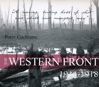 Eltham District Historical Society Inc
Book, ABC Books for the Australian Broadcasting Corporation, The Western Front 1916-1918 by Peter Cochrane, 2004
"Using both official and unofficial photos, this is a powerful visual record of the ANZAC experience of the Western Front, WW1 - the scene of some of the bloodiest horrors and the greatest loss of life. Australian photographer." --Publisher's description.138 pages : illustrations, portraits, map ISBN 0733312802world war 1914-1918, australian imperial force, anzacs, military campaigns, western front -
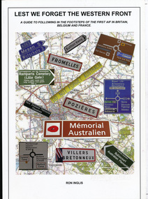 Eltham District Historical Society Inc
Book, Ronald William Inglis, Lest we forget the Western Front : a guide to following in the footsteps of the first AIF in Britain, Belgium and France, 2010
A guide to sites and memorials relevant to the first Australian Imperial Force in Britain, Belgium and France in the First World War170 p. : ill. (some col.), maps (some col.), ports. ; 30 cm.ISBN 9780646519920australian imperial force, war memorials, world war 1 battle fields -
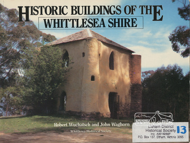 Eltham District Historical Society Inc
Book, Robert Wuchatsch 1950- et al, Historic buildings of the Whittlesea Shire / Robert Wuchatsch and John Waghorn, 1985
Historical accounts of 55 buildings which portray the Shire of Whittlesea's diverse history. Contains 70 photographs, all full page, 12 in colour. Each is accompanied by a comprehensive account of the homes' origins and changing ownerships through the generations. There are also drawings and a map of the Shire of Whittlesea. Reference to the Peter Lalor Home Building Co-Operative Society Ltd., a project devised to overcome the critical shortage after World War 2. Produced as part of the celebrations for Victoria's 150th anniversary by the Whittlesea Historical Society. A photograph of Bear's Castle at Yan Yean Reservoir is on the cover.Paperback; [114] p. : ill. (some col.), 1 map ; 19 x 25 cm.ISBN 0958866309buildings, shire of whittlesesa, bear's castle -
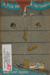 Eltham District Historical Society Inc
Book, Mary Kent Hughes, Matilda waltzes with the Tommies / by Mary Kent Hughes (T/Major Thornton, R.A.M.C.), 1943
Hardback with dust jacket; 176 p. : ill., maps, ports. ; 22 cm.mary kent hughes, world war ii -
![Book, Garrie Hutchinson, Remember them : a guide to Victoria's wartime heritage / [written & photographed by Garrie Hutchinson], 2009](/media/collectors/4f729f7b97f83e03086018a5/items/59278b33d0cdd112c0eaedec/item-media/5bac35ae21eafa1568280d77/item-fit-380x285.jpg) Eltham District Historical Society Inc
Eltham District Historical Society IncBook, Garrie Hutchinson, Remember them : a guide to Victoria's wartime heritage / [written & photographed by Garrie Hutchinson], 2009
Hardback; xii, 308 p. : col. ill., maps ; 24 cm. ISBN 9781740668408war memorials, monuments, world war 1, world war ii, boer war, victoria -
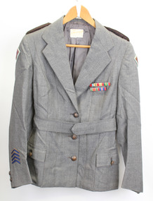 Warrnambool RSL Sub Branch
Service Jacket; Army Nurses Uniform, Early 1940's
This uniform was worn by Sister Winifred Ride during World War 2.. Nurses played a key role in the conflict through their care and compassion to the servicemen who were wounded and sick.The nurses uniform is symbolic of the sacrifice and service of the many women who served their country in WW2. Grey fitted, lined jacket with long sleeves, collar and lapels. Three front metal buttons buttons and two smaller buttons on each sleeve. Dark green epaulette with four metal buttons on each shoulder (Right side is faded). Two hip pockets with one button fastener. One internal pocket with small grey button. Unit patches on each sleeve and four inverted service chevrons on right sleeve at wrist. Two ribbon bars containing 5 Campaign Ribbons on left side of front, attached with standard 'brooch' fitting . Belt (same material as jacket) passes through two loops on back of jacket and is fastened by two buttons, hidden when belt is fastened. Metal buttons stamped with map of Australia with crown above and the words Australian Military Forces around. Makers label inside back below collar: " /tailors and habit makers, J .RAVENSDALE & SON Nicholas Bldg Swanston Street Melbourne". Name of owner handwritten "Sister Ride:" -
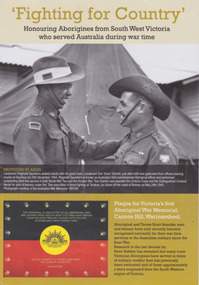 Warrnambool and District Historical Society Inc.
Booklet, 'Fighting for Country' Honouring Aborigines from South West Victoria who served Australia during war time, February 2014
This booklet was collated and printed for the 2014 Lake Bolac Eel Festival, ‘Return to Country’. The author, Peter Bakker, has spent several years researching the part played by south western Victorian aborigines and this booklet details the results of this research. Several of the soldiers came from the Warrnambool area.This is a booklet of ten pages with printed material and black and white and colour photographs and a map.Front Cover: ‘Fighting For Country – Honouring Aborigines from South West Victoria who served Australia during War Time’ (plus other printed material) Back Cover: Map and List of Service Men and Women of Aboriginal Descent with connections to South West Victoria aborigines from south west victoria, return to country, lake bolac eel festival, peter bakker, world war one, world war two, korean war, vietnam war -
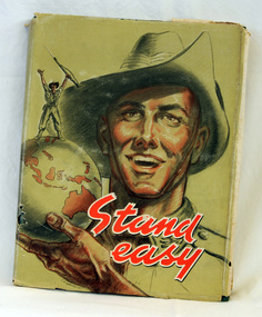 Orbost & District Historical Society
Book, Halstead Press, Stand Easy, 1945
This book was part of a series of books published for the Australian Military Forces by the Australian War Memorial in Canberra. Contents for the book came from the Australian military forces in early 1945 and the book was ready for printing at the beginning of August, ready for Christmas release. The title signified the ending of the war to the north of Australia.This book is a significant contemporary record of the participation of Australian soldiers in World war 11.A 208 pp book with a dust jacket which has a picture of a soldier wearing a slouch hat holding a world globe with Australia to the front. a soldier is standing on top of the globe holding a bayonet high. The title, "Stand Easy" is in red print at the bottom right. The hard cover of the book inside the dust jacket is green with the wording 'Stand Easy after the defeat of Japan, 1945' in pale green, along with an image of a soldier waving a gun above his head. It contains prose accounts of the war, cartoons, photographs, verse, illustrations and maps.inside cover - " To John Gilbert Esq..........from Capt Shannon Tallagoota Orbost Victoria"military world-war-11 book-stand-easy -
Ringwood and District Historical Society
Envelope, Packet: War Workers (WW2) - Fall of Singapore, Burma Railway Map, Special Editions of Newspapers 1992-993
World War II - Newspapers - 50th anniversary editions; The Australian - Special edition "The Fall of Singapore", "The Day Destiny Struck", Australia at War, Map of Burma Railway -
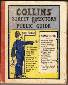 Cheese World Museum
Book, Queen City Printers Pty Ltd, Collins Street Directoryand Publice Guide: 8th Edition
The Percy Uebergang family lived at Tooram Park, Allansford from 1912 until 1992. This booklet was part of the collection of items given into the care of the Cheese World Museum. Uebergang catalogue No. -not listed White hard cover pocket-sized street directory book with red cloth spine. The front cover has a blue and yellow background with title, contents, edition listed and a policeman in a blue uniform. The back cover has information in black print. Melbourne and suburbs maps throughout. 439 pages.COLLINS' STREET DIRECTORY/AND/PUBLIC GUIDE/8th Edition/2/6 each/CONTENTS/ Suburban Maps/Street Indices/Public Buildings/Tourist Information and Holiday Notes/Weights and Measures/Postal Rates/Calendar/Conversion Tables/Justices of the Peace/And other useful and up-to-date matterallansford, uebergang, street directory, public guide, collins, melbourne, maps, tourist information, queen city printers pty ltd, almanacs, local history -
 Australian National Surfing Museum
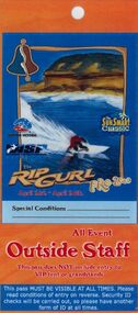
Surf Contest Pass, 2000 Bells Beach Competition Pass, 01/03/2000
This event access pass was issued to staff, vendors and community volunteers at the 2000 Rip Curl Pro at Bells Beach.The access pass is typical of the pass issued each year to the staff and workers at the longest running surfing contest in the world. The pass features unique Indigenous artwork by Torquay artist/surfer Glenn Romanis2000 Rip Curl Pro Access Pass. Full colour laminated access pass (Outside Staff) for the 2000 Rip Curl Pro and Sunsmart Classic. The pass features cover art by Indigenous artist Glenn Romanis and event management logos. The pass also features a site map on the back and access information.Event management logos on the front. Indigenous Bell artwork by Torquay artist/surfer Glenn Romanis.bells beach, rip curl, glenn romanis, surfing victoria, 2000 rip curl pro -
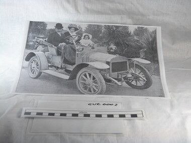 Gippsland Vehicle Collection
Book, Darge, Victoria's Leaders in the Motor Car World, 1911 (estimated); Based on make & models of vehicles, maps, and articles
Book of "Darge" photographs c.1911. Algenon Darge was a noted photographer in Melbourne around the commencement of the 20th century. 124 pages"The property of Bramwell" "thanks Fred" "Fred Armylope\19/7/68"melbourne, melba, dame nellie melba, gippsland, cars, darge, broadbent, road map, advertisements, touring, james flood, hudson, berliet -
Glen Eira Historical Society
Letter - Australia Remembers
Letter from Clyde Holding, M. P., dated 21 10 1994, to Don Taggert President, HistoricalSociety of St Kilda, Inc, inviting him to a luncheon to discuss the involvement of the community in the program Australia Remembers, 1945 – 1995 commemorating the fiftieth anniversary of the end of World War 2.Includes time – line of proposed activities, suggested activities, and map of venue meeting. Australia remembers, 1945 – 1945, five page booklet (4 copies) on proposed program for fiftieth anniversary of the end of World War 2. Includes list of key people, criteria for grant approvals, and time – line. 3. Two more copies of the previous. 4. Certificate of appreciation signed by David Kemp, M.P. for Goldstein, dated 10, 1995, to the Caulfield Historical Society, for contributing to the commemoration of the peace in August 1945. Also, a printed certificate presented to the Caulfield Historical Society, signed by Con Sciacca M.P., and Clyde Holding M.P., in recognition of your valuable contribution to the Australia Remembers program during 1995. 5. Letter from Clyde Holding M.P., dated 5 November 1995, to Mrs Felicity Campbell, President of the Caulfield Historical Society, forwarding the Certificate of appreciation mentioned in previous.world war 2 1939 – 1945., wars., war memorials., st. kilda., caulfield., historical societies., caulfield historical society., kemp david, goldstein. -
 Glen Eira Historical Society
Article - MONASH UNIVERSITY CAULFIELD CAMPUS
This folder contains 6 items about this educational institution: 1/Undated colour slides showing various angles of two different building facades of Monash Caulfield Campus. 2/Article 'Martens Matters' re launch of exhibition of covesr of OASE 33 Magazine by Designer Karel Martens. Date noted as 01/04/2011 in 'The Age'. 3/Collection of 6 separate cards, all Priority Development Panel Submissions, Design Visualization, dated May 2006 (Architectural drafts) dated 31/03/2006 plus 2 identical cards dated 01/05/2006 - all drawings and one plan for NHArchitecture. 4/Collection of 4 colour separate cards, all Priority Development Panel Submissions, Design Visualization for Architect Wojciech Huszek of existing buildingsdated 31/03/2006. 5/Collection of 4 colour separate cards all Priority Development Panel Submissions, Design Visualization of existing buildings by photographer Andrius Lipsys, dated March 2006. (No architect stated.) 6/Article 'Uni rank sign of the Times' from Glen Eira Port Phillip Leader dated 12/03/2013 concerning Monash University’s world ranking in 100 best universities.nharchitecture, altoon and porter (master planner and urban designer ), huczek wojciech (architect), lipsys andrius (photographer), martens karel, station square development, campus map, derby lane, princess lane, post office place, caulfield station, sir john monash drive, derby road, the hub, the mat, post office square, station square, zagame’s hotel, dandenong road, oase 33, art and design building, monash university, caulfield campus, caulfield east, universities, tertiary education -
 Federation University Historical Collection
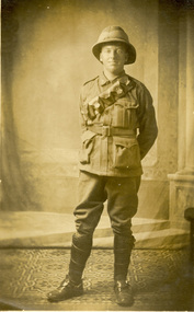
Postcard, Harold Reid, c1916
Harold Reid, dressed in Australian Army uniform poses for a photograph during World War One. Verso 'Harold Reid, taken at place where we have our maps printed.'chatham family archive, chatham, holmes, world war, world war 1, world war i, world war one, france, harold reid, reid -
 Federation University Historical Collection
Book, Victoria Education Gazette and Teachers' Aid, 1911-1919, 1910-1919
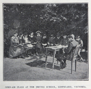
Black hard covered book with red spine, holding Victorian Education Gazettes for one calendar year. .1) 1910 .2) 1912 .3) 1911 .4) 1914 .5) 1918 Images: Open Air Classroom Black Rock; Open Air Classroom, Jeetho, Gippsland; Open Air Nurses bedroom, Mildura; Gym at Canterbury School ; Babies and Nurses at Melbourne Foundling Hospital; Camp at Portland; Alexander Peacock Opens a Melbourne School; Unveiling Major Mitchell Memorial at Mt Arapiles; Agricultural Plot; School Interior; Swimming Drill; Graham Dux Prize Board; Bathing Place; Classroom with blackboard and pictures; Major Mitchell's Map; Melbourne, Derbyshire; Market Place Melbourne; The Blackwood; World War One Send-off at The Athenaeum; Scarsdale Old Boy's logo; Sloyd articles for the Field Hospital; World War One; Gifts for Transport to the Wharf; soldiers; ANZAC Day; ANZAC Day Medalion .5) 1915: Education Department's War Relief Fund, William Park obituary, Closer Settlement Act 1912, Agriculture, needlework, Swimming and Life Saving, explorers, Gregory Blaxland, Matthew Flinders, Composition, Geography, potatoes, onions, gardens, Needlework for Infants, Iona and Staffa, Trained Primary Teacher's Course, Electricity, Electrical Technology, hygiene, Arbour Day, Horticulture, Wattle Day, Bird Day, Technical Schools, Landing at Gaba Tepe, Evils of Alcohol, Old Boys of Scarsdale, Belgium, Teachers' College Images: The British at War, The Sonnet, History and Patriotism, Male Swimming Teachers Summer School at Geelong, Women Swimming Teachers at Port Fairy, Buln Buln State School, Burwood East State School, needlework plans, methods of Rescue and Resucitation. plan of the journey of Gregory Blaxland, Macquarie House, teachers killed (William Ross Hoggart, Stanley Robert Close, William Roy Hodgson, Campbell McDiarmid Peter, William Henry Dawkins, William Hugh Hamilton, Frederick McRae Neal, Vernon Brookes, Frank J. Olle, Alfred J. Collins, Ernest R. Fairlie, William J. McLaren, A.E. Smith, Thomas Patton, Francis W. Kemp, Frederick G. Hall, Rupert O. Hepburn, Woolston J. Govan), Frederick Harold Tubb VC, Botanic Gardens Red Gum, Shelter Pavillions, Head of Wheat, Australian Commonwealth Flag, Iona Cathedral, Drawing exercises, ANZAC Madallion, School Rolls of Honor .6) 1916 - Nature Study, war relief, school gardening, horticulture, singing class, geography of the war, School Rolls of Honour, Ponsonby Carew-Smyth, Astronomy, ANZAC Day, Empire Day, Arbor Day, "Some Suul of Goodness in Things Evil" by Frank Tate, War Relief Gardeners' League, ANZAC Day medallion, Solar System, Abolition of German Schools in Victoria, ANZAC Avenues, avenues of honour, Geography of the War: The West, War relief and handwork, Victorian State Schools Horticultural Society, Patrick Maloney obituary, formalin lamps, Victoria League of Victoria, Wonwondah East Roll of Honor Images - Teachers killed (John Clarke, A.C.H. Jackson, Alexander Robertson, Noel Gambetta, Ralp E. Leyland, Laurance J. Woodruff, Walter E. Cass, Percy D. Moncur, Thomas M. Carmichael, Edward G. Brain, Reginald N.F. Woods, George E. James, William Colvin, David Dobson, Stanley L. Robinson, Charles Allen, G.E. James, H.F. Curnow, Franl L. Cousins, James R. Thompson, Henry H. Campbell, George E. Read, Ernest D. Morshead, Wilfred S. Merlin, Henry R. Wright, George B. Webb, Noel Nicholas, David H. Thomas, Charles A. Levens, Thomas R. Fenner, John M. Daniell, P.J. Larkin, Ralph Smith, Philip Ormsby), school rolls of honour, Swimming Instructors at Queenscliff, The Southern Sky, Map of the North Sea and its Littorals, Easter School of Horticulture at Oakleigh, Map of the Eastern Front, Map of Mesopotamia, Map of the War Area in the Egyptian Campaign, leeches for the Melbourne Hospital .7) 1917 - Swimming and Life-Saving, Childre's FLower Day, Education Department's War Relief Fund, State War Council, Horticulture, Bird Day, Swimming, Growing Chicory at Cowes Images - Teachers killed during World War One (G.M. Nicholas, William C.W. Spencer, J.W.C. Profitt, Ivon C. Bromilow, John Colwell, Robert W. Campbell, Arthur P. Bourchier, Francid G. Houston, Claude N. Harrison, Edgar Williams, Leslie A. Stevens, Charles E. W. Chester, Stanley R. Green, Walter Baker, Arthur G. Scott, Harry L. Swinburne, Horace W. Brown, Arnold Bretherton, Edward W. Jenkins Aubrey Liddelow, Ewen A. Cameron, Edmund R. Lyall, John H. Martin, Harry Bell, Frank L. Nicholls, Melville R. Hughes, Edwin W. Hauser, Walter S. Filmer, Walter G. Barlow, Henry A. Donaldson, Edward H. Jones, Walter W. Raw, Alfred W. Dean, Wiliam Lea, Frederick G. Drury, J.T. Richards, Norman G. Pelton, Lance-Corporal Doran, Kenneth F. McKenzie, William F. Robertson, Wiliam Jarrott, Norman Graham, George G. Paul, Victor Green, Arthur William Rennie, Alfred J. Glendinning, Robert B. Liston, Eward P. Toll, George Jones, Errol E. Rodda, Christian P. Christensen, Charles F. Sydes, H.G. Clements, Norman C. Fricker, J.M. Romeo. Eric N. Lear, Thomas J. Bartley, Norval Birrell, Frederick H. Tubb. J.T. Hamilton Aram, Arthur Wilcock, William M. Conroy, Alex. H. Miller, Patrick J. Cunningham, Charles S. Mitchell, John R. Maddern, James Roadknight, Harry Arundel, Jack C. McKellar, duncan M. McKellar, George S. Manfield, Edgar C. Holmes, George A. Young, Raymond A. Gardiner, William B. Bell, William Opie, George R. Scott, Richard V.B. Vine, Herbery S. Marshall, Hugh St Omer Dentry, George B. Fullerton, Harry Oulton, Iva F. Morieson), School Honor Books, Drawing, Presentation of 30,000 pounds to the British Red Cross at Melbourne Town Hall .8) 1918 .9) 1919 - Photographs of World War One soldiers from the Education Department, Margaret Montgomery Memorial, 1918 Act relating to State School Teachers, State Scolarships, Victorian State Schools' Horticultural Society, Pneumonic Influenza, Spanish Flu, epedemic, swimming and life savinfJunior cadet training, vacancies in Fiji, School Committees, Arbor Day, Arbour Day, Henry Harding of Yinnar, Planting Trees and Shrubs, Juvenile Crime, The use of 'Get', Soldier-Teachers from Overseas in Congress London, Australia's Effort in the War, Military, Working Bees, Tree Planting, fence building, Welcoming Home a Returned Soldier, Avenue of Honour planting, Discipline, Unveiling an Honor Board, School gymnasium, school tennis court, E. E. Crogger grave at Aldershot, The School Honor Book. War Relief Fund, Commonwealth War Record, Caulfield Military Hosptial, ANZAC Day Pilgrimage, Jimmie Panikin, Donald Fraser, Arthur Mee, Card Sun Dial, Balboa Day in Honolulu, William Hamilton, Alfred Jackson, The Backward Child, Flies, Language Teaching and Learning, Spelling, The Education of the Adolescent, victorian education gazette, education gazette and teachers' aid, sloyd, william a. cavanagh, james i froebel, school, education, world war one, memorials, alfred williams, exploration and settlement, cadets, australian naval college, bernard o;dowd, birds, swimming, drawingempire league, eucalypts, paper in history, forestry, arbor day, identification of trees, forestrey museums, fiji, gravel hill school band, horticulture, hygiene, gould league of bird lovers, life saving, la perouse, bandin, j. holland, w. hamilton, charles sturt, principles of archimedes, james holland, william hamilton, scarsdale old boys' reunion, foundling home melbourne, montessori education, open air schools, james hughes, marie corelli, flinders sydney harbour, major mitchell's map, tooth brushing, r.h.s. bailey -
 Federation University Historical Collection
Book, Official History of Australia in the War of 1914-1918, Vol 3, The Australian Imperial Force in France, 1916, 1937
Red hardcovered book of 1035 pages and 475 illustrations and mapsworld war, world war one, charles bean, france, bean, frommelles, messines, somme, pozieres, mouquet farm -
 Federation University Historical Collection
Banner - Book, Charles E.W. Bean, Official History of Australia in the War, Vol 1, The Story of ANZAC: The first phase, 1937
Red hard covered book of 662 pages, 111 maps and 56 illustrations.Inside front in pencil "H.J. Sims"world war, world war one, charles bean, aif, egypt, anzac, sims, h.j. sims -
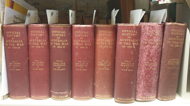 Federation University Historical Collection
Book, Charles E.W. Bean, Official History of Australia in the War, Vol 3, The Australian Imperial Force in France, 1917, 1937
Red hard covered book of 1030 pages, with 423 illustrations and maps.world war, world war one, charles bean, aif, anzac, lagnicourt, messines, ypres, menin road, polygon wood, broodseinde ridge, passchendale, hill 60, hill 70, benafay wood, hindenburg line, hooge dump, butte, bapaume, bullecourt