Showing 8399 items matching "mckillops-bridge"
-
 Eltham District Historical Society Inc
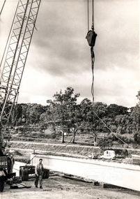
Photograph, Construction of Lower Plenty Bridge, Main Road, c.August 1966, 1966
This black and white photograph records construction activity of the then new Main Road bridge over the Plenty River at Lower Plenty in 1969.Local significanceBlack and white photograph taken during construction of the Main Road bridge over the Plenty River. Includes structural members, construction personnel, vehicles and a Clarke mobile crane.mobile cranes, bridge construction, main road, plenty river, lower plenty, bridges -
 Port Fairy Historical Society Museum and Archives
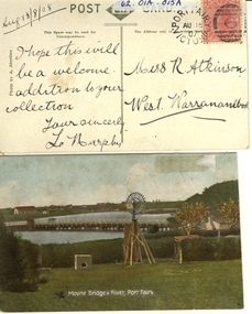
Postcard - post card, A.C. Aberline, Moyne Bridge & River Port Fairy, c.1900
A card sent to Miss R. Atkinson of West Warrnambool to add to her collection of postcardsHand coloured Photograph of the Moyne river road bridge, a domestic windmill in foreground and in the background large sheds made for use as a postcard with reverse side stamped Front:- Moyne bridge & river, port Fairy. Reverse:- aug.13/8/08- i hope this will be a welcome addition to your collection yours Sincerly, L Murphy - To Miss R Atkinson, West Warrnambool moyne bridge, moyne river, windmill -
 Ringwood and District Historical Society
Research notes, John Rodaughan, Burnt Bridge Hotel - Newspaper clippings and handwritten notes including list of early owners. (Demolished 1964)
Newspaper clipping and collection of various sized handwritten notes on the history and a brief anecdote of Burnt Bridge Hotel including a list of the early owners of the hotel and a newspaper article on the closure of Burnt Bridge Store demolished in 1964.Early Burnt Bridge Hotel Owners; 1891-92 Thomas Willis; 1893-96 J.G. Jones; 1897-00 Sammuel ?; 1901 Mary Hampton; 1902-05 ? Smith; 1906-07 Miss Clarke; 1908-09 Hacke ?; 1910-12 Frank J Hack; 1913 Frank Johnson; 1914 Sidney R Ritchie; 1915 Mrs S Rowlands; 1916 Mrs M Pearson -
 Eltham District Historical Society Inc
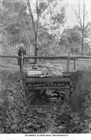
Photograph, The Rose Stereograph Company, Log Bridge, Eltham Road. Greensborough, c.1920
A woman stands at the end of a log bridge over a creek looking towards the south along the unsealed roadway. The sun illuminates her back. She is wearing a woollen knit beanie with edges rolled up, dark jacket and skirt, full length dark stockings and slip on dark leather shoes with raised heel, typical of the early 1920s. The creek is possibly feeding into the Karingal Yalloc. The direction of the road based on shadows is northwest as is the Eltham Road to Greensborough (present day Sherbourne, Karingal and St Helena roads). The creek is falling to the foreground so from south west to the north east, possibly feeding into the Karingal Yalloc, somewhere near presenet day Ramptons Road Reserve. This glass plate negative was used to manufacture postcards (1:1 printing) for commercial sale by the Rose Sterograph Company and its subsidiaries. George Rose founded the Rose Stereograph Company in 1880 and was joined by Herbert (Bert) Cutts in the early 20th Century. The pair formed a lifetime working partnership and strong personal friendship. Assisted by George’s two sons, Herbert George and Walter, and later by Neil Cutts, the Rose Stereograph Company continued its operations for more than 140 years. The company was initially built on stereographs, but as cinema took over and stereographs fell out of fashion, the Rose Stereograph Company developed Australia’s first commercially viable photographic postcard business. Specialising in postcards of iconic historical moments and significant landmarks, The Rose Stereograph Company became a staple of the Australian travel industry.This remarkable collection of glass plate negatives, transparencies, and postcards – arguably Australia’s most significant photography collection outside of public hands – has been passed down through the generations, surviving war, relocation, and the harsh Victorian climate. The historic Rose Stereograph collection is the culmination of George Rose’s dream of capturing and preserving precious moments in time and remains the legacy of the Rose and Cutts families. It is with great sadness that the Cutts family says goodbye to a collection that spans five generations and 140 years. The Cutts family understands that for these historically important pieces to rest with one family is to deny others the pleasure of their custodianship.Glass Plate Negative Size: 9.2 x 13.8 cmLog Bridge, Eltham Road, Greensborougheltham, postcard, travel, rose stereograph company, glass plate negative, creek, eltham road, greensborough, karingal road, karingal yallock, log bridge, sherbourne road, st helena road, women's fashion, rampton's road reserve, peter and elizabeth pidgeon collection -
 Sunbury Family History and Heritage Society Inc.
Photograph, Timber road bridge, May 1986
The small wooden bridge is spanning an arm of the Moonee Ponds Creek in its upper reaches in Greenvale near Woodlands Park, possibly along Providence Road.A non-digital black and white photograph with a white border of a timber bridge spanning a small creek, which is under a roadway. A country home is visible on the opposite side of the road.bridges, greenvale -
 Orbost & District Historical Society
black and white photographs, C1970
These photographs are of the 1922 road bridge across the Snowy River at Orbost. This bridge over the Snowy River was opened on July 4 1922. It was constructed in 1922 alongside the previous suspension bridge. Its building was a combined effort of the Victorian Railways and the Country Roads Board at a cost of 35,000 pounds. It was replaced in 1976 by the present bridge after several major floods.This bridge was replaced in 1976 after several major floods. These photographs are pictorial records of the 1922 brige.Two small black / white photographs of a road bridge across a river. 3248.1 is a close-up of wooden pylons.on label on back - "Snowy River Bridge at Orbost 1922 Bridge"bridge-orbost snowy-river-bridge -
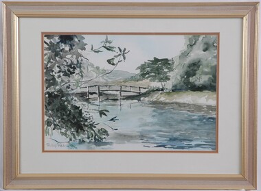 Glenelg Shire Council Cultural Collection
Painting, Phillip Petrie, Langley's Bridge, 1990
Depiction of a bridge over a creek edged with trees. On left are the branches of a tree with grey-green leaves. The creek fills the lower centre area of the image, painted in pale blue, grey, highlights of white and darker areas of dark blue. The wooden rail bridge curves in an even arch in centre of image. On right is a bank rising from the creek, with large tree with pale grey-green foliage and a tree with darker olive foliage. The background shows what could be hills and the sky is very pale blue. Mounted in a double matt (white on orange), framed under glass in wooden frame with gold details.Front: Phillip Petrie 90 (lower left) (grey paint). Back: "Langley's Bridge" watercolour. 570 x 420 mm $150.00 -
Whitehorse Historical Society Inc.
Article, A Bridge Too Far, 2016
Residents, MPs were outraged over an approval given by Planning Minister, Richard Wynne, to Deakin University.Residents, MPs were outraged over an approval given by Planning Minister, Richard Wynne, to Deakin University to build a bridge spanning Gardiners Creek Reserve linking both sides of its Burwood campus.Residents, MPs were outraged over an approval given by Planning Minister, Richard Wynne, to Deakin University. wynne, richard, deakin university burwood campus, gardiners creek reserve, burke, anna, watt, graham -
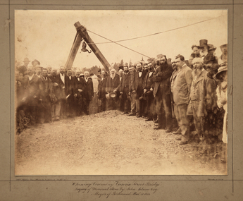 Kew Historical Society Inc
Photograph, Opening Ceremony Victoria Street Bridge: Laying of memorial stone by John Adam Esq. Mayor of Richmond, 1884
A formal group photograph of the grand opening of the Victoria Street Bridge on March 31 1884. The Argus was to report that: ‘The ceremony of laying the memorial stone of the Victoria-bridge, which connects Kew and Hawthorn with Richmond and Collingwood, was performed yesterday afternoon by the mayor of Richmond (Mr John Adam) in the presence of a large assemblage. Among the gentlemen present at yesterday’s proceedings were the mayor of Collingwood (Mr. M. Dwyer), the Mayor of Melbourne (Councillor C. Smith, M.L. A.) the mayor of Kew (Mr. Barnard), Mr. J. A. B. Koch and Mr. W. W. Shelley (ex mayors of Richmond), Mr. Joseph Bosisto, M.L.A., the Hon. L. L. Smith, Councillor De Mole (ex mayor of Kew), Mr. Jas. Lancashire and Mr. Winter (ex mayors of Ricmond), Mr. Walker (ex mayors of Collingwood), Mr. Johnson (engineer), Mr. C. Rowan, C.E. (engineer of the bridge alterations) and the town clerks of Richmond, Collingwood and Kew.’ Following the opening ceremony ‘… a ponderous steam roller was driven over the structure, with a view to test, or rather to demonstrate its stability … Most of the gentlemen present walked over the bridge, after which they were grouped by a photographer, with the memorial stone as a central feature, and several views of the scene were taken’.An original, rare silver albumen mounted and titled photograph of an important event in 19th century Melbourne.Original photograph mounted on display card of the opening of the Victoria Street Bridge. The original photograph is very faded and has been enhanced to improve the image's viewability.On the reverse of the card is an indecipherable stamp and an inscription identifying the photographers. "T. W. & C. A. McAlpine Bros, Photographers &., Campbell Parade East Richmond Melbourne March 31.1884victoria street bridge, john adam, m. dwyer, c. smith, barnard, j.a.b. koch, w.w. shelley, bridge, kew, collingwood, l.l. smith, joseph bosisto -
 Melton City Libraries
Photograph, Melton Railway Bridge, c.1884
"The Melton Viaduct, opened in 1886, is of State heritage significance as a very large and visually distinctive wrought iron, lattice girder trestle bridge over the Werribee River (now Melton Reservoir). It comprises 18.3 and 9.1 metre spans, in a generally alternate arrangement, of total length 375 metres, and standing 38 metres over the Werribee River. Wrought iron small section iron was used to build tension trussed trestle legs, which supported four lines of rivetted wrought-iron deck-type double lattice trusses. It has bluestone abutments and pier bases of coursed rock-faced bluestone with drafted margins. The larger half-piers, now usually submerged in the Melton Reservoir have sharp tapered cutwaters and curved coping at the tops. While designed to carry two rail tracks it has only ever been used as a single track line. Despite several alterations to its deck structure, it remains an outstanding example of a lighter structural design employing open metal trestle supports and metal truss girders. The direct Melbourne to Ballarat railway link of which the Melton viaduct was the major engineering work contributed significantly to the history and development of Victoria. This new link reflected Ballarat’s diversifying economy as well as the commercial and political influence of the metropolis. Construction of the bridge, and the associated large workers camp, were extensively photographed, documenting an important episode in local history. The railway enabled the development of new industries in the Melton area, notably the timber industry and a chaff industry of national importance, greatly facilitated the later transition of the Shire from a pastoral to a farming economy, and struck a major blow to Melton township’s era as a wayside town servicing Ballarat road (especially coach) traffic". Melton Railway Bridge being built across the Werribee Rivertransport -
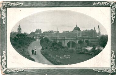 Melbourne Tram Museum
Postcard, Marlborough Art Series, Princes Bridge Melbourne, 1910
Photograph of Princes bridge Melbourne with one cable tram set crossing. In the background is the then new Flinders Street station building. Note the clock on the right hand side of the photograph that was later transferred to Spencer Street station. Yields information about Princes Bridge in 1910.postcard - decorative border with a photo of Princes Bridge within an oval - embossed. On the rear is a letter dated 21/12/1910. Card by Marlborough Art Series.See note on rear.tramways, trams, yarra river, princes bridge, cable trams, flinders street station, clocks -
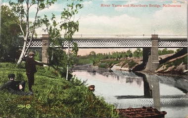 Kew Historical Society Inc
Postcard, Valentine's Series, River Yarra and Hawthorn Bridge, Melbourne, c.1907
Valentine's Series postcard, printed in Great Britain by Valentine’s Co. Ltd. (Valentine & Sons 1825-1963) for Australian distributionEarly postcard of the Hawthorn to Burnley Railway Bridge on the River Yarra. Station picnic on left. Tay Creggan on right. Buildings and location identified by Marshall Slattery in 1977. The postcard was printed in Great Britain and was published as one of Valentine's Series. "KH.87. Donated by Mrs B. Challen 2.2.76. Burnley to Hawthorn Railway Bridge. Station Picnic on left. "Tay Creggan" on right. Marshall Slattery 1977".river yarra, railway bridge - hawthorn, postcards -- hawthorn (vic.) -
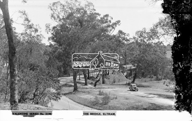 Eltham District Historical Society Inc
Negative - Photograph, The Rose Stereograph Company, The Bridge, Eltham, c.1939
Looking west across the Main Road Bridge over the Diamond Creek at Eltham, c.1939. The car in the foreground, possibly the photographer's, is a Ford Model C Ten built by Ford UK between 1934 and 1937. The Model C was released in Australia in 1935. The Ford Model C Ten is a car that was built by Ford UK between 1934 and 1937. The Model C was released in Australia in 1935 https://en.wikipedia.org/wiki/Ford_Model_C_Ten This glass plate negative was used to manufacture postcards (1:1 printing) for commercial sale by the Rose Sterograph Company and its subsidiaries. George Rose founded the Rose Stereograph Company in 1880 and was joined by Herbert (Bert) Cutts in the early 20th Century. The pair formed a lifetime working partnership and strong personal friendship. Assisted by George’s two sons, Herbert George and Walter, and later by Neil Cutts, the Rose Stereograph Company continued its operations for more than 140 years. The company was initially built on stereographs, but as cinema took over and stereographs fell out of fashion, the Rose Stereograph Company developed Australia’s first commercially viable photographic postcard business. Specialising in postcards of iconic historical moments and significant landmarks, The Rose Stereograph Company became a staple of the Australian travel industry.This remarkable collection of glass plate negatives, transparencies, and postcards – arguably Australia’s most significant photography collection outside of public hands – has been passed down through the generations, surviving war, relocation, and the harsh Victorian climate. The historic Rose Stereograph collection is the culmination of George Rose’s dream of capturing and preserving precious moments in time and remains the legacy of the Rose and Cutts families. It is with great sadness that the Cutts family says goodbye to a collection that spans five generations and 140 years. The Cutts family understands that for these historically important pieces to rest with one family is to deny others the pleasure of their custodianship.Glass Plate Negative Size: 9 x 13.9 cmThe Bridge, Eltham, Valentine Series No. 3196, Copyrightpeter and elizabeth pidgeon collection, bridge, cars, diamond creek (creek), eltham, eltham south, ford model c ten, glass plate negative, main road, main road bridge, motor vehicles, postcard, rose stereograph, rose stereograph company, valentine series postcard -
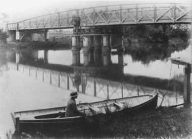
 Kew Historical Society Inc
Photograph - Kane's Bridge on the Yarra River, December 1934
In 1928 a footbridge was erected to link Kew with the public golf course across the Yarra. The total cost of construction came to 250 pounds and the bridge became known as Kane's Bridge. During the 1934 floods the bridge was washed downstream, and was subsequently rebuilt. The present form of the bridge resembles the earlier bridge which crossed from the Yarra Bend Asylum to Kew, further upstream. (VHD)Original, black and white positive of Kane's Bridge in December 1934, when the 'great flood' of the Yarra caused the bridge's destruction. Inscribed verso: "Kane's Bridge Yarra in flood Dec 1934"river yarra, yarra -- kew (vic.), kanes bridge, 1934 floods -
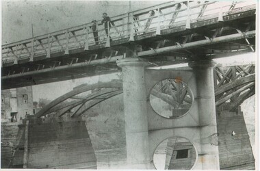
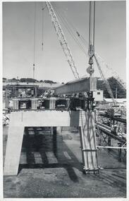 Phillip Island and District Historical Society Inc.
Photographs, Country Roads Board, Phillip Island 2nd Bridge Construction, 1966 - 1969
Eight of a collection of 70 photographs taken at the time of the Phillip Island second bridge construction by Country Roads Board & Shire of Bass. Contractor John Holland & Co Pty LtdEight Black & White photographs of the construction of the 2nd Phillip Island Bridge from San Remo to Newhaven - built from 1966 to 1969. Photographs showing various aspects of the construction.351-43: CRB NEG No. 67-1930E. Placing 1st Beam on Span 3. 351-44: CRB NEG No. 67-1930F. 1st Beam on Span 3. 351-45: CRB NEG No. 68-2126H. 351-46: CRB NEG No. 68-2126B. 351-47A: CRB NEG No. 67-2708A. 351-47B: CRB NEG No. 67-2708C. 351-48: CRB NEG No. 67-2708D. 351-49: CRB NEG No. 66-2860Aphillip island 2nd bridge construction, phillip island bridge, country roads board, shire of bass, john holland & co pty ltd, sasha stark -
 Lakes Entrance Historical Society
Photograph, Caire, Nicholas John, Swing Bridge Sale Victoria c1905, 1905c
Latrobe Bridge Sale Victoria in closed position . The operating machinery is still visibleBlack and white photograph of the Latrobe Bridge, in its closed position. The operating machinery is visible, plus the unique pier structure of the central span. In the rowing boat moored along side the river bank, a person wearing a boater hat is seated. Sale Victoriawaterways, bridges, civil engineering -
 Rutherglen Historical Society
Photograph - Image, c1895
The 'new' John Foord Bridge was built between1887 and 1895, and replaced an 1862 timber bridge constructed by a company involving John Foord. A plaque, placed on the bridge by the The Institution of Engineers, Australia names it as a "NATIONAL ENGINEERING LANDMARK". Black and white photograph of two bridges. One appearing below the span of the other. The bridge in the foreground has just been opened and the old wooden bridge, being demolished, is shown in the background.Written on back of photo: "John Foord Bridge, Wahgunyah. New & old"john foord bridge, bridges, murray river, wahgunyah, corowa -
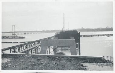 Phillip Island and District Historical Society Inc.
Photographs, Country Roads Board, Phillip Island 2nd Bridge Construction, 1966 - 1969
Fifteen photographs from a collection of 70 taken at the construction of Phillip Island 2nd Bridge from 1966 - 1969 by Country Roads Board and Shire of Bass. Contractor John Holland & Co Pty Ltd.Fifteen Black & White photographs of the construction of the Phillip Island 2nd Bridge from 1966 - 1969 by Country Roads Board. Various photos of materials, machinery and people involved in the construction.351-50: CRB NEG No. 66-2860G. 351-51: CRB NEG No. 67-2866. 351-52: CRB NEG No. 67-2867B. 351-53: CRB NEG No. 66-2958A. 351-54: CRB NEG No. 66-2958B. 351-55: CRB NEG No. 67-3070E. 351-56: CRB NEG No. 67-3070F. 351-57: CRB NEG No. 64-3280B. 351-58: CRB NEG No. 67-3356G. 351-59: CRB NEG No. 66-3462D. 351-60: CRB NEG No. 66-3465G. 351-61: CRB NEG No. 66-3466D. 351-62: CRB NEG No. 67-3535D. 351-63: CRB NEG No. 67-3535H. 351-64: CRB NEG No. 67-3535M.phillip island 2nd bridge construction, phillip island bridge (1969), country roads board, shire of bass, john holland & co pty ltd, sasha stark -
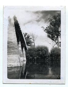
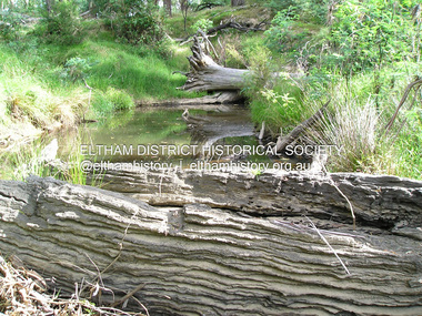 Eltham District Historical Society Inc
Photograph, Fay Bridge, Old timbers in the Diamond Creek at Hurstbridge, 27 February 2018
Just downstream from the bridgefay bridge collection, diamond creek (creek), hurstbridge, 2018-02-27 -
 Port of Echuca
Photograph, Original photo c.1920
The iron bridge was completed in 1878 and was used by the Deniliquin and Moama Railway company for goods trains only - it was another year before passengers were included in the transport service. On 4 March 1879 citizens of Echuca and Moama stormed the bridge, opened the gates and declared it open for their use.At the turn of the century the railway line carried produce from southern New South Wales & the Riverina to Melbourne, with goods trains being a very important mode to transport. When the bridge was being constructed, six workmen were killed and another maimed when a pile on the Moama bank collapsed. After the storming of the bridge by local people in March 1879 it was declared open for use of local residents traveling between the towns of Echuca and Moama. The bridge was shared by rail, road and pedestrian traffic.An image of the iron bridge at Echuca, taken looking East from Victoria bank.Verso: "Iron bridge"murray river bridge , echuca, murray bridge, echuca, iron bridge, echuca -
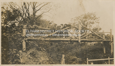 Eltham District Historical Society Inc
Photograph, "Curry, Byrne, McGeachy & self on rustic bridge, Eltham", 22 Oct 1919
The old Diamond Street bridge in Eltham had a raised section seen here and a lower section, the railings of which can just be seen. The upper pedestrian crossing provided continual access for foot traffic during times of flood. This photo is part of the Alice Broadhurst collection held by Yarra Plenty Regional Library, a series of 12 photo albums compiled by Alice Broadhurst (1896-1981), initially while working as a Voluntary Aid Detachment nurse with the Australian Red Cross at the Mont Park Military Hospital (No. 16 AGH) and subsequently as a nurse at the Royal Melbourne and Royal Women’s hospitals alongside many pioneering doctors of their fields. This photo depicts an outing with fellow VAD nurses McGeachy and Byrne and two patients of Mont Park, Curry and Caffery to Eltham in spring 1919 Digital file"Curry, Byrne, McGeachy & self on rustic bridge, Eltham, Oct 22, 1919"eltham, diamond creek, diamond street bridge, alice elizabeth broadhurst, byrne, caffery, curry, mcgeachy, nursing staff, mont park, 16 agh -
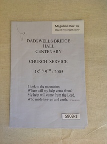 Stawell Historical Society Inc
Book, Dadswells Bridge Hall Centenary Church Service 18th/19th/2005, 2005
Order of service for the Dadswells Bridge Hall centenary, Church Service.Pale Blue/Grey Paper with black PrintDadswell Bridge Hall Centenary Church Service 18th - 19th 2005 I Look to the mountains; Where will my help come from? My Help will come from the Lord, Who made heaven and earth..... Psalm 121stawell religion -
Port Melbourne Historical & Preservation Society
Pamphlet - Proposing West Gate Bridge, The Lower Yarra Bridge, 1968
Found in Lois Daley's father's technical manual''The Lower Yarra Bridge': brochure proposing West Gate Bridge, 1968engineering - bridges, west gate bridge, lower yarra crossing authority -
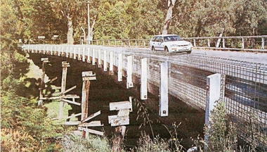 Stawell Historical Society Inc
Photograph, Delley's Bridge Halls Gap
White vehicle crossing Delley's Bridge Halls Gap c 2000. This Bridge has been replaced at Halls Gap with a new bridgetransport, bridge -
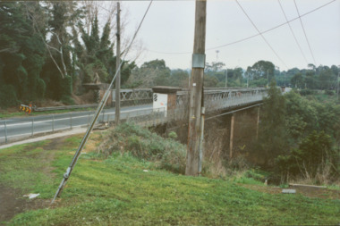 Kew Historical Society Inc
Photograph - Former Chandler Highway Bridge, 2001
The heritage listed Fairfield Bridge was originally constructed for the Outer Circle Railway to bridge the Yarra River between East Kew and Fairfield stations. In the 1930s it was converted for vehicular traffic. In the 2010s a new concrete bridge was erected beside it to increase vehicular capacity. Original colour print positive of the (former) Chandler Highway bridge in 2001. The point of view is from the Fairfield side of the river looking towards Kew. The heritage listed bridge was originally constructed for the Outer Circle Railway to bridge the Yarra River between East Kew and Fairfield stations. In the 1930s it was converted for vehicular traffic. In the 2010s a new concrete bridge was erected beside it to increase vehicular capacity. Ink inscription on reverse: "Chandler Highway bridge / (Originally Outer Circle Railway Bridge) / From Fairfield side towards Kew / July 2001"bridges -- kew (vic), fairfield bridge, chandler highway bridge, outer circle railway viaduct -
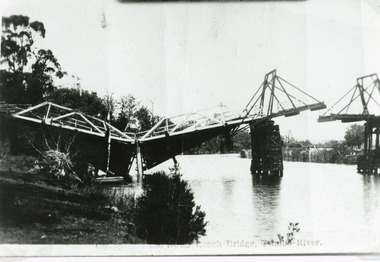 Lakes Entrance Historical Society
Photograph - Bridges, Bulmer H D, 1925
Swan Reach Bridge collapsed 10.00 am 16 November 1925Black and white photograph showing collapsed bridge over the Tambo River, bridge collapsed at eastern end. Photo looking downstream. Two people on landing on far right bank behind right hand bridge pylon. Thick vegetation on bank. Swan Reach VictoriaSwan Reach Bridge on the Tambo Riverwaterways, boats and boating, disasters -
 Marysville & District Historical Society
Photograph (Item) - Black and white photograph, 1953
A black and white photograph of a bridge over the Steavenson River in Marysville in Victoria.A black and white photograph of a bridge over the Steavenson River in Marysville in Victoria. The Steavenson River is named after the Victorian Assistant Commissioner of Roads and Bridges, John Steavenson who arrived in Victoria in the early 1860s.THE BRIDGE/ MARYSVILLE '53 7340marysville, victoria, steavenson river, photograph, john steavenson -
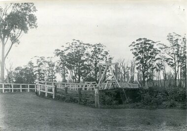 Orbost & District Historical Society
black and white photograph, August 1897
This is a photograph of the bridge from the Orbost side. The first pile bridge over the Snowy River was just completed by Mr Jim Granter when the 1891 flood took out the centre,. There were differences of opinion as to whether the council should pay . The Shire Secretary, Mr John Draffin, persuaded them to honour their obligations. Mr Granter and Mr Clarke finished it as a suspension bridge which was opened by Mrs William Watt. Soon after a mob of cattle stampeded, the weight snapped the cable, letting one side sag. Mr R.P. Cameron repaired it and this bridge remained until 1922. "In 1890 the contract for a bridge was let to Mr James Granter for £1450. This structure with additions and improvements made to it was to cost the ratepayers about £2,500, and its erection was proceeded with in a very satisfactory manner until, just as the greater-part of the work had been completed, the flood of 1891 came down on it, piling up mountains of logs, timber and debris against the piers, which had not been made wide enough apart to allow for. contingencies of this kind. The structure held out bravely until the turn of the flood and then gave way with a crash, about five bays from the centre disappearing in the stream." ( Snowy River Mail August 12 1893) This item is a pictorial record of one of the first bridges across the Snowy River in Orbost.A black / white photograph of the old wooden suspension bridge over the Snowy River. There are two copies 919.1 and 919.2. There are two other photos showing the whole bridge taken from further back.on back - "Orbost Bridge...."snowy-river-bridge-orbost granter-james -
![View of Sailor’s Creek Bridge / [by] Nicholas Caire, circa 1876](/media/collectors/550653872162f11fb04854aa/items/577b5b7ed0cdd10948d14ae1/item-media/577b5be9d0cdd10948d196a2/item-fit-380x285.jpg) Kew Historical Society Inc
Kew Historical Society IncPhotograph, Anglo-Australasian Photographic Company, View of Sailor’s Creek Bridge, c.1876
Nicholas Caire was born on Guernsey in the Channel Islands in 1837. He arrived in Adelaide with his parents in about 1860. In 1867, following photographic journeys in Gippsland, he opened a studio in Adelaide. From 1870 to 1876 he lived and worked in Talbot in Central Victoria. In 1876 he purchased T. F. Chuck's studios in the Royal Arcade Melbourne. In 1885, following the introduction of dry plate photography, he began a series of landscape series, which were commercially successful. As a photographer, he travelled extensively through Victoria, photographing places few of his contemporaries had previously seen. He died in 1918. Reference: Jack Cato, 'Caire, Nicholas John (1837–1918)', Australian Dictionary of Biography.An original, rare photograph from the series 'Views of Victoria: General Series' by the photographer, Nicholas Caire (1837-1918). The series of 60 photographs that comprise the series was issued c. 1876 and reinforced a neo-Romantic view of the Australian landscape to which a growing nationalist movement would respond. Nicholas Caire was active as a photographer in Australia from 1858 until his death in 1918. His vision of the Australian bush and pioneer life had a counterpart in the works of Henry Lawson and other nationalist poets, authors and painters.Views of Victoria (General Series) No.31 / ‘View of Sailor’s Creek Bridge’ / Albumen silver photograph mounted on boardOn Reverse" ‘Sailor’s Creek as situated in the Jim Crow Ranges, which Range forms a portion of the Great Dividing Range of Mountains in Victoria. These hills contain many romantic spots. The one which forms the subject of the present illustration is a view of the Bridge which spans the Creek. Gold has been found throughout the course of the bed of this Creek in payable quantities. The diggers, as may be seen in the photograph, have constructed sluices in the side of the embankment for the purpose of washing the fine gold contained in the wash-dirt.’nicholas caire (1837-1918), sailor's creek (vic), gold mining (vic) -
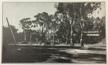
 Eltham District Historical Society Inc
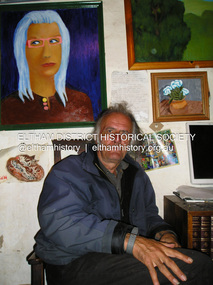
Photograph, Fay Bridge, Damien Skipper at his place residence at Montsalvat, 9 April 2018
2018-04-09, Damian Skipper, Fay Bridge Collection, Montsalvatfay bridge collection