Showing 1120 items matching "orchard house"
-
 Whitehorse Historical Society Inc.
Article, A Grand way to live, 2007
... a substantial orchard. The house at 48 Shafer Road, Blackburn North ...The house at 48 Shafer Road, Blackburn North is Edwardian and once boasted a substantial orchard.The house at 48 Shafer Road, Blackburn North is Edwardian and once boasted a substantial orchard. It was built in 1903 by Victor Lawford for his daughter Isobella Blanche HollondsThe house at 48 Shafer Road, Blackburn North is Edwardian and once boasted a substantial orchard. shafer road, blackburn north, no. 48, hollonds, isobella blanche, lawford, victor -
Whitehorse Historical Society Inc.
Document, Zander Avenue, 7/01/1986
Memories by Merle Duncan recorded 7/1/1986. Zander Avenue named after the Zanders who had an apple orchard there. Wright Family owned a milk bar in Springfield Road and they built Mountain view shops in Springfield Road. The old manse, now the Nunawading North Community House was their home. Nicoll Reserve was a pear orchard owned by the Aytons.roads and streets, zander avenue, nunawading, nunawading, duncan, merle, wright family, mountain view shops, springfield road, nunawading, nicoll reserve, ayton family, zander family -
 Whitehorse Historical Society Inc.
Photograph, Mrs Collier and baby George
Series of photographs loaned for copying by Robert Collier through Keith Rooney. Photographs have been scanned by Ted Arrowsmith at 300dpi as a 'tiff' and burnt onto a CD Rom. copies of photographs were produced from the CD Rom for inclusion in the album.Black and white photograph of Mrs Collier carrying Baby George Collier in front of their house on 50 acres in Canterbury Road, Forest Hill, Then Blackburn. This was site of the Nunawading High School.collier mrs, collier george, canterbury road, orchards, tunstall -
 Whitehorse Historical Society Inc.
Photograph, Houses in the big Orchard, c1960
... The houses in the big orchard from Mr. Boyle's.... boyles white bruer's The houses in the big orchard from Mr ...Photographs relate to the Poultry Farms that existed in Nunawading and Forest Hill in the1950s and 1960s. Photos taken in 1961-62. Poultry farmers included Messrs Boyce, Gallos, Foote,Grimsley, Greenwood and Dudley.|Slides scanned as a 'tiff' at 300dpi to CD Rom and cleaned and adjusted by Ted Arrowsmith.The houses in the big orchard from Mr. Boyle's.eckermann's, eckermann frank, poultry farms, nunawading, greenwood, forest hill, canterbury road, mount pleasant road nunawading, boyles, white, bruer's -
 Whitehorse Historical Society Inc.
Photograph, Game Family Home, C.1916
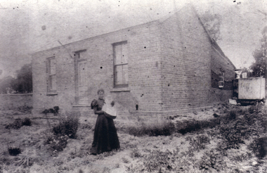
Black and white photo of Game Family Home, 18 Gordon Crescent, Blackburn. Land at side of house belonged to the property, at left was an orchard, the whole surrounded by Pines, very neglected during World War 1. C.1916.game, gladys, tom, kate -
 Whitehorse Historical Society Inc.
Photograph, Pupils Outside Mitcham State School, 1/10/1924 12:00:00 AM
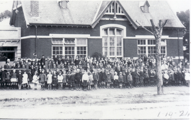
Information - J.Bamford: 'In the late 1930's and 40's there were two parts of the Mitcham State School. The Bubs and grades 1 to 3 were in a building on Mitcham Road that was near the laneway behind the shops,and grades 4 to 8 were further down Mitcham Road. There were several houses on Mitcham Road to the left of this photograph, with parkland behind.. The left rear of the school also joined the park. The right side of the school joined Sampson's orchard, which went down as far as Springfield Road. This road was then called the Stock Route because that was what it was back then.' By the number of children present, it appears that both sections of the school got together for this 1924 photograph.field, jean., mitcham state school, no. 2904, mitcham road, mitcham, victoria street mitcham -
 Whitehorse Historical Society Inc.
Functional object - Butter Churn
Believed to have been owned originally by Alice and Arthur Fisher who had a 16 acre property in Mullum Mullum Road, Ringwood. The house was called Greenhill and was located at the highest point, now no. 28. They had a mixed farm including an orchard of fruit and nut trees, and a dairy cow. Alice milked the cow much to the amusement of her English family, who delighted in visiting. When the property was sold the butter churn went to Red Hill on the Mornington Peninsula. Arthur Lunt, donor has memories of its use in Red Hill, where his parents had a mixed farm. That property was sold c. 1950, and the butter Churn returned to the Ringwood Croydon area where it has remained unused for the last 65 years.|The butter churn has been in Croydon and Ringwood since 1952; it is typical of manually operated equipment in use on small properties 100 years ago.Cylindrical container, brown, mounted on board with handle underneath. To one side is a wooden handle and drive gears to spin cylinder. Cylinder has tight fitting lid and makers metal label on the side; opposite side has direction arrow embossed. Mounted on wooden base. Cream was put into churn, handle turned to spin drum until butter was produced. Five parts to the Churn.SVENSKA STOCKHOLM SWEDEN CENTRIFUGA,B.DAHLIA N0:0 SLATER PATENTdomestic items, food preparation -
 Whitehorse Historical Society Inc.
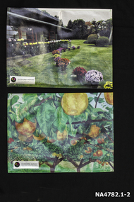
Memorabilia - Table mats, 2016
Table mats presented after a visit to Schwerkolt Cottage and Museum Complex by delegates from City of Whitehorse's sister city MatsudoSymbol of White horse City and City of Matsudo's friendshipTwo table mats presented to WHS by our sister city Matsudo. Number 1 shows Togo Tea House built in 1884 with the garden in the foreground with pots of chrysanthemums in many colours. An insert in the left hand bottom corner 'Whitehorse-Matsudo Sister Cities Celebrating Friendship'. With black circle on left side with a yellow and pink flower and 1971 on it. Number 2 is Named ' Pear Orchard' with background of green trees gold pears hanging from branches. Insert in left hand bottom corner as above.Whitehorse- Matsudo Sister Cities Celebrating Friendship.domestic items, food & drink consumption -
 Whitehorse Historical Society Inc.
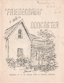
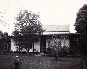
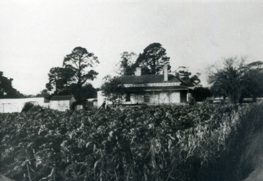
Document, Friedensruh Doncaster, 1849
A history of the house ' Friedensruh' and the Thiele family in early DoncasterA history of the house ' Friedensruh' and the Thiele family in early DoncasterA history of the house ' Friedensruh' and the Thiele family in early Doncasterthiele, gottlieb, friedensruh, doncaster, germans in australia, oswald, schools, german evangelical lutheran church, orchards, frederick, alfred, william, elsa -
 Whitehorse Historical Society Inc.
Photograph - Black and white photo, Orchardist's House, 1/09/1983 12:00:00 AM
Black and white photo of orchardist's house built about 1880-1900. 3Almondsbury Court, North Blackburn. Side verandah on left was altered to make another room.orchards, almondsbury court, blackburn, no. 3 -
 Whitehorse Historical Society Inc.
Photograph, Old House and Garden, 1/06/1969 12:00:00 AM
... was on part of the orchard. Old House and Garden Photograph Photograph ...Black and white photo of cabbage garden and old house on Canterbury Road beside Vermont State School. This was Mr. Tilson's house which was on part of the orchard.vermont state school, no. 1022 -
 Whitehorse Historical Society Inc.
Photograph, Livermore's Orchard
... of Livermore's Orchard, Morack Road, Vermont looking east from house ...Coloured photo of Livermore's Orchard, Morack Road, Vermont looking east from houselivermore, douglas, clem, orchards -
 Whitehorse Historical Society Inc.
Article, Repair Cafe, 11/10/2023
A repair Cafe has opened at Strathdon House on the second Saturday of each month (January excepted) from 10 - 2 run by HealthAbility to repair household items.non-fictionA repair Cafe has opened at Strathdon House on the second Saturday of each month (January excepted) from 10 - 2 run by HealthAbility to repair household items.strathdon orchard, healthability -
 Whitehorse Historical Society Inc.
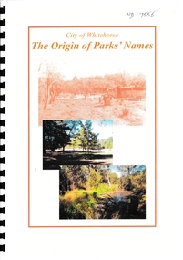
Booklet - The Origin of Parks' Names, City of Whitehorse Parks and Reserves: Names and Origins
List of more than 50 Whitehorse Parks and Reserves and the Name OriginAn incomplete list of more than 50 parks and reserves in Whitehorse and the origin of their names. Printed copy with plastic spiral binding with front and back plastic covers. Some photo originals faded.non-fiction List of more than 50 Whitehorse Parks and Reserves and the Name Origincity of whitehorse, parks and reserves, halliday park, box hill gardens, yarran dheran, schwerkolt cottage, gardiners creek reserve, whitehorse reserve, walker park, slater reserve, old strathdon orchard, morton thomas, boer war memorial linsey park, kyalite, elmore walk, john gardiner, bruce and daisy campbell, upton house, ballyshanassay, blackburn lake -
 Whitehorse Historical Society Inc.
Photograph, Cook Family
William Cook was one of the earliest settlers in Vermont. Having returned from the W.A. goldfields he married Jane Maggs in 1880 at Wickliffe, Victoria and his only child, Amy, was born in 1881 at Box Hill. William Cook's property fronted Whitehorse Road, Mitcham and ran north almost to the Mullum Mullum Creek. He shared part of his eastern boundary with the Schwerkolt family. William Cook specialised in cherries and became known as 'The Cherry King'Sepia photograph mounted on card of a woman and a girl standing in front of a wooden house with iron lace on the verandah. A path leads down the side of the house.cook, amy, jane, orchards -
 Whitehorse Historical Society Inc.
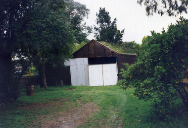
Photograph, 12 Quarry Road, Mitcham, 1998
This shed was on part of the orchard property of Mr Henry Ireland of 12 Quarry Road Mitcham. He has cleared the property and planted an apple orchard by about 1910. When he died in 1947 the orchard was cut up. Mrs Ireland lived in the house until she died. Her daughter married and rebuilt the house, but the outbuildings remained the same, at least until 1998.Coloured photograph of a path leading across a lawn to an old shed with white doors.ireland, henry, quarry road, mitcham, orchardists -
 Whitehorse Historical Society Inc.
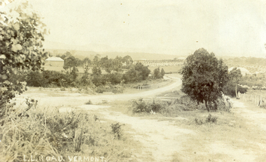
Photograph, L L Road Vermont, late 1800
Dr L L Smith was a pioneer of the Vermont District. He owned 250 acres in the area bounded by Boronia, Canterbury and Heatherdale Roads and the creek. The property was known as L L Vale after which the road was named. Name was changed to Boronia Road in later years. He was a Doctor with rooms in the City, was a member of Parliament.Sepia Postcard of L L Road, Vermont (now Boronia Road) taken in the early 1900s (card is postmarked 27 Aug 1909). Shows the road going down it is presumed to the creek. It is possible that the house is that of Dr.L.L.Smith. See History.|Orchard in background is the Finger orchard. (from Mr. Shambrook - Tim's father)|Information on the back of the Postcard reveal it was sent to Miss Roberts of 61 Hoddle Street Richmond Victoria by Muriel at 37 Victoria Road Northcote and was posted at the Fairfield Post Office Victoria on 27 August 1909. Text is 'Dear Ethel Just a Post Card to let you know I will be out to see you on Monday if convenient. I came down with Mr Hutchinson and he asked me what were we laughing out on the Sunday when he came up. Muriel|See the following references -ND199, 313, 539. 1242, 2013, 3680 & 4295.l l road vermont, boronia road vermont, smith . l l dr -
 Mt Dandenong & District Historical Society Inc.
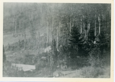
Photograph, View Over Roof of "Kalorama"
Taken in 1908, this photograph, though rather blurry, gives an indication of the location of the early settler properties in the valley in relation to one another. European trees have been planted at 'Kalorama' , the first home of Ellis Jeeves. John Lundy-Clarke grew up in the Kalorama/Mt Dandenong area and later in life (1972-74) began to write a comprehensive history of the area working from an original settlement map in an effort to cover all areas.Black and white photograph looking across hillside with large trees and rooftops visible. Handwritten description on reverse by John Lundy-Clarke.1908 View over roof of “Kalorama” towards the Falls. Paynter’s house on LOT 29 in low centre (now “Yosemite”). Pimms house on LOT 19 above Paynters and beyond scrub. Logan’s house faint above left of “Kalorama”. Dunbar’s LOT 20 beyond Pimm’s orchard. Gum trees on right were on Price’s LOT 19 now Tosari Rd area. It was one of these that figured in the episode of the runaway log in 1930. It leaped in one bound over Barbers Road at bottom of scrub in centre of picture then over Logan’s house.kalorama, ellis jeeves, jeeves -
 Mt Dandenong & District Historical Society Inc.
Photograph, View From Corner of Doughty's Road and Barbers Road 1913
John Lundy-Clarke grew up in the Kalorama/Mt Dandenong area and later in life (1972-74) began to write a comprehensive history of the area working from an original settlement map in an effort to cover all areas. Taken c1913, this photograph gives a clear indication of where significant buildings were located in relation to one another. Barbers Road is running through the picture with the guest house 'Kia-Ora' , built by George Barber in the centre. High on the skyline on the left is the 'Mountjoy' guesthouse, indicating the location of The Gap, or FiveWays. The small 'boxy' house above 'Kia-Ora' is 'Iona' built by the Paynter family who also built 'Mountjoy'. The Jeeves property 'Kalorama' is to the right of 'Iona' and this is the area you now look to from the FiveWays Lookout. The man in the photo is wearing a trilby hat so is probably a Rose Series employee - a feature in many Rose Series postcards.Black and white photograph that is a copy of Rose Series Postcard # 156. A man can be seen walking down an unmade road with haystacks to his right. Buildings and crops can be seen on the hillsides. Handwritten inscription on reverse by John Lundy-ClarkeView from corner of Doughty’s and Barbers Road 1913. “Kia Ora” in centre Paynter’s “Iona” near center skyline above “Kia Ora” with “Kalorama” on its right and Peter’s hut of the time below it among orchard trees. “Mountjoy” is on left skyline. W. Haye’s home is centre left. Hay paddock is Barbers Lot 25 Village Settlement.kia-ora, iona, kalorama, mountjoy, guesthouse, guest house, barbers road, doughty's road, paynter, jeeves, george barber -
 Mt Dandenong & District Historical Society Inc.
Photograph, Harmony Vale, c1913
View of Harmony Vale, the original Kalorama settlement taken from Barbers Road. Child's sawmill can be seen (centre) with the log yard to the right. Richardson's home "Harmony Vale' is in the orchard above the logs.Black and white photograph copied from a Rose Series postcard showing the area known as "Harmony Vale' - the original Kalorama settlement. Child's sawmill is in the centre.Rose Series Photo of Harmony Vale on the Olinda Creek taken from Logans Lot 28. Link Rd crossing centre Shiloah complex left centre. Richardsons (Jeannie’s) “Mt Calvin” between trees above tree fern. Isaac Jeeves house with the tree fern floor among trees against forest right centre. Mill yard with logs above cultivated flat. Mill to left. “Harmony Vale” homestead among orchard above logs. “Glenrivers” in gully at top of clearing. About 1913. Copied JLC 1973harmony vale, harmony vale, child's sawmill, sawmill, barbers road, richardson, shiloah -
 Mt Dandenong & District Historical Society Inc.
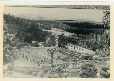
Photograph, View of Raspberry Crop and Orchard in Price Family Property
Wide view showing raspberry crop and orchards on Price Family property with home of Norman Jeeves in foreground and Hubert Jeeves' Motor garage to the left. Long, dark building is now gallery. Tea House/Post office right of centre and Mountjoy Guest House up on hill. fiveways, jeeves, mountjoy, orchard, tea rooms, price, crop -
 Mt Dandenong & District Historical Society Inc.
Photograph, View of valley looking south over 'Kalorama' towards falls, 1908
... ” is Logan’s house on Lot 28. House against orchard was Pimm’s later... house on Lot 28. House against orchard was Pimm’s later Prince’s ...View taken 1908 looking south over 'Kalorama', home of Ellis and Eliza Jeeves, across the valley towards the falls.This photograph has a detailed inscription on the back handwritten by John Lundy-Clarke in 1974.View taken 1908 of valley looking south over “Kalorama” towards the falls. House right of “Kalorama” was Paynter’s “Iona” on Lot 29. Faintly below line of Barber’s Road above “Kalorama” is Logan’s house on Lot 28. House against orchard was Pimm’s later Prince’s Lot 19. Big trees on right were on Price’s Lot 18 and were between Tosari Rd and Rosemont Cres. It was FROM one of these being cut up in 1931 that the round length log weighing ½ a ton got away from the splitters and raced down the hill in bounces, one of which cleared Barber’s Rd and Logan’s house in leaping from the fence line above the road.kalorama, paynter, iona, barbers road, ellis jeeves -
 Mt Dandenong & District Historical Society Inc.
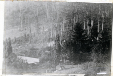
Photograph, 1913 View Over Logan's House in Village Settlement, 1913
... 1913 view over Logan’s house on Village Settlement Lot 28... the orchard row beyond the house. “Shiloah” is centre partly behind ...Photograph taken in 1913 from Barbers Road showing the view down the valley. Roof in foreground is house on Bob Logan's Lot 28 in the Village Settlement. This photograph has a detailed inscription on the back handwritten by John Lundy-Clarke in 1974.1913 view over Logan’s house on Village Settlement Lot 28 taken from Barber’s Road. This is the house that the runaway log leaped over in 1930 to land far down the orchard row beyond the house. “Shiloah” is centre partly behind the clump of trees and the paddocks of Child and Richardsons pioneer selections are in the background. Link Road is centre right.logan, bob logan, robert logan, barbers road, shiloah, child, richardson, link road -
Southern Sherbrooke Historical Society Inc.
Information folder - Elvery family
Folder contains information pertaining to the Elvery family of Belgrave Heights. Contents: -Trifold A3 pamphlet, glossy paper, black, white and orange "The Lodge Just the perfect place to stay" c1990s advertisement flyer. -Map, hand-drawn with photos attached, "9 Hole Golf Course. Belgrave Heights - 1930-1943". Photocopy of large poster made by Betty DeCoite (original in map drawer) -Photocopy of photo, annotated in ink "Photo taken in Dandenongs - possibly Monbulk/the Patch? Photo supplied by David Elvery 2/6/99" -Photocopy of photo, Belgrave South Football Club team, probably 1945, plus list of names of team - from David Elvery 2/6/99 -printout, State Library of Victoria Multimedia Catalogue, Rose Series postcard of "Sunnyside Lodge" Lockwood, Belgrave South -copy of printed letter from David Elvery to CEO Shire of Yarra (sic) dated 8/6/99 re. vegetation on Mt Morton. Handwritten additions plus p'copy of Valentine Series postcard #3832 "Panorama From Mount Morton, Belgrave Heights" -p'copy of typed speech with annotations, by Rev. A.C. Beckingham at the opening of Lockwood -p'copy of photo, Harrison and Dalny Elvery and children David and Wendy c1936. Annotated by David Elvery 30/5/99 -printout, SLV Multimedia Catalogue, Rose Series postcard "Lockwood House" Lockwood, Belgrave South -p'copy, subdivision map "Lockwood Estate" lodged plan 6548 -p'copy, subdivision map Lockwood area, plan #6970 -A3 sheet, p'copies 6 postcards of Belgrave Heights -p'copy photo Elvery house, later "Sunnyside" and "Devon Lodge" annotated by David Elvery 2/6/99 -3 p'copied photos, Belgrave Heights, possibly Varney's butchers shop, possibly Whitlam residence. Annotated by David Elvery -2 p'copied photos, "Lockwood House", Golf links (Bill Woodfull, Principal of Upwey High School in photo), annotated David Elvery 2/6/99 -2 photos from David Elvery - moving Melbourne tram into "house" location at Lockwood, and bus "W. Dyke" unknown date and location. -3 photos from David Elvery - David on Gypsy (pony) Mt Morton Rd c1937, Wendy and David at entrance 37 Lockwood Rd c1942, David on Mack (horse) on golf links c1947 -Photo Arthur and Harrison Elvery, Lockwood House in background c1916 -photo Mrs Elvery, p'copy of postcard 26/3/20 addressed to "Dear Maud", mentions Charlie's wife and Laura (incomplete) -photo George Rae (Narre Warren North) Harold Allen and three other boys c1939 -6 photos, unlabelled (duplicates?) -photo Orchard Rd, Belgrave Heights -photo unlabelled, woman with child in pram, house in background (Lockwood?) -photo David Elvery on Gypsy as above -Rose postcard P2032 "Lockwood" Belgrave, Victoria -photo David Elvery on Mack (as above) -photo Wendy and David Elvery (as above) -2 photos, tram being moved (as above), football team -p'copy of Certificate of Title Vol.4562 Fol. 912336 dated 31/1/1922 - see list of names in folder -p'copy Memorial of Instruments (Land Title) dated 14/1/1914 -p'copy Cert. of Title Vol. 4562 Fol. 912335 dated 31/1/1922 -handwritten note, David Elvery to Susan Heywood-Downard -p'copy Memorial of Instruments dated 14/1/1914 -p'copy subdivision map, area bounded by Glen, Orchard, Avonside and Bay Rds, Belgrave Heights -p'copy Cert. of Title, Vol. 4810 Fol. 961945, dated 2/1/1924 -p'copy Cert. of Title, Vol. 4562 Fol. 912337, dated 31/1/1922 -Typed list of photo caption, relating to some of above photos -List of names and dates appearing on land title documents enclosed -Printout, Australian Dictionary Of Biography - Davies family - handwritten addition, marriage details, Arthur Elvery & Hannah Ord. -Printout - Family Search, Maria Louisa Davies, and family group, Ebenezer Davies & Ruth Bartlett. -letter to editor, Northern Star, Lismore, NSW, 11 Aug. 1923, Hannah Elvery, re. sport on Sunday -typescript - Elvery Family History, part of the "Alstonville" Elvery story, supplied by David H. Elvery 30th May 1999. From Bob Quincey.elvery family, lockwood house, belgrave heights, devon lodge -
 Southern Sherbrooke Historical Society Inc.
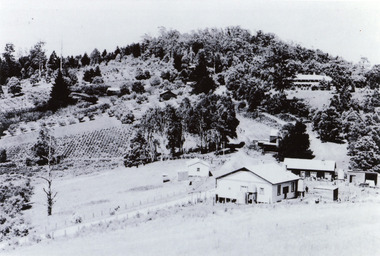
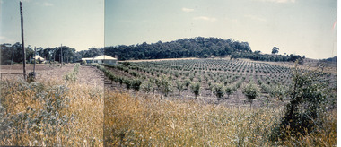
Photograph - Photo-colour- Montague apple orchard, 1954
... house with the orchard that was planted in 1952... photograph of Bill and Stella Montague's original house ...Colour photograph of Bill and Stella Montague's original house with the orchard that was planted in 1952 in the foreground. The home of Alf and Marion Montague (Bill's parents) is on the left. A line on the left side indicates this is two photos stuck together to form a panorama. Trees in orchard appear to be quite young. -
 Bendigo Historical Society Inc.
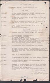
Document - R.S.L. BENDIGO COLLECTION: TIME TABLE FOR R.S.L. VICTORY BALL 1951, 21st August, 1951
Typed time table for the R.S.L. Victory Ball held at the Town Hall, Bendigo on Tuesday 21st August, 1951. Signed by J. W. Swatton, Hon. Secretary Ball Committee.J.W. Swatton, Secretary.event, social, victory ball, r.s.l. bendigo collection - time table for r.s.l. victory ball 1951, mr f e jackson, sir george lansell, lt general wells & mrs wells, mrs oliver, mrs j w swatton, mrs f e jackson, cr oliver, rsl ladies auxiliary, parma dance club, mr wright, mr little, mr w lamers, mr waters, mr green, mr barton, mr palmer, mr edgar, mr orchard -
 Bendigo Historical Society Inc.
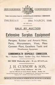
Document - IAN DYETT COLLECTION: AUCTION CATALOGUE - COMMONWEALTH DISPOSALS COMMISSION
Three Auction catalogues for a sale on 28th March, 1946 of Extensive Surplus Equipment including Perspex, Rubber and Amoric Hose, Paint, Micrometers, Vices, Mess Canteen Plant, Excellent Tools and Miscellaneous Equipment at Commonwealth Disposals Commission, No. 1 Auction Depot, Garden City, Port Melbourne. Columns for £, S and D on the right side of the page. Contains descriptions of some lots. J. H. Curnow & Son were the auctioneers. The Prahran Telegraph Printing Co. were the printers of the catalogue.business, auctioneers, j h curnow & son pty ltd, ian dyett collection - auction catalogue - commonwealth disposals commission, j h curnow & son, j l jamieson, w g wedd, the prahran telegraph printing co, park orchards, dept. of navy -
 Bendigo Historical Society Inc.
Newspaper - Aileen and John Ellison Collection: Newspaper article
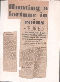
Three newspaper articles, date unknown. One titled: "Hunting a fortune in coins" the second "Disgusted" and the third one " Treasure in apple orchard all three articles refer to the Harris brother and their supposedly buried fortune. The articles are glued to a piece of cardboard.axedale, harris family -
 Kew Historical Society Inc
Photograph - 'Wimba', Cotham Road, J E & B L Rogers, c.1965
'Wimba' is of significance as one of the key nineteenth century houses of Kew and for remaining in a substantially intact state. Although probably built some time earlier, the first mention in the Rate Books of the property later known as 'Wimba Lodge' appears in the entry for 1870 when the property, owned by John Sharpe Denbigh, a civil servant, was given an N.A.V. of £72 2. Denbigh did however occupy a house in Cotham Road in 1863, and it is possible that was the same premises'. The house was occupied by Denbigh until at least May 1876 when the 'family residence...' \ 'as auctioned to Carlington George Edmund Marston 5, a chemist of Smith Street, Collingwood. At the time of the auction the house was described thus: The residence and grounds of the late J.S. Dendigh, situate in the most elevated part of Cotham Road Kew. The grounds comprise an area of 4a Or29p or thereabouts, and have a frontage to Cotham-road of 4 chains. The house has two large rooms in front, with 6ft hall built of brick, bay and side windows (plate glass), four rooms of wood behind with slate roofs, bathroom and closets, detached kitchen and servant's room, large shed with washing boiler, pantry and cellar under, brick and cement tank, and the Yan Yean laid onto house and grounds, cowshed, pigstye, &c, the whole securely fenced. First class orchard and flower garden. The paddocks laid with English grasses and drained... .' (Sanderson P, City of Kew Urban Conservation Study, Volume 2, 1988)This work forms part of the collection assembled by the historian Dorothy Rogers, that was donated to the Kew Historical Society by her son John Rogers in 2015. The manuscripts, photographs, maps, and documents were sourced by her from both family and local collections or produced as references for her print publications. Many were directly used by Rogers in writing ‘Lovely Old Homes of Kew’ (1961) and 'A History of Kew' (1973), or the numerous articles on local history that she produced for suburban newspapers. Most of the photographs in the collection include detailed annotations in her hand. The Rogers Collection provides a comprehensive insight into the working habits of a historian in the 1960s and 1970s. Together it forms the largest privately-donated collection within the archives of the Kew Historical Society.The front entrance of Wimba in Cotham Road, Kew. The entrance is flanked by two polygonal bay windows, and a verandah with a concave corrugated iron roof returns around three facades, and accentuates the projections of the windows. The solid render parapet is very ornate and tall for the date of construction. It has panels of decoration along it and is surmounted by a number of render urns. The image was used by Dorothy Rogers in 'A History of Kew' (1973), facing page 144.Wimba ca. 1860 built by J.S. Denbigh (has been altered).wimba, kew, dorothy rogers -
 Kew Historical Society Inc
Functional object - Wrought iron nails from 'Reno', St John's Parade, c. 1864
Comparatively few weatherboard houses in Kew survived from the early years of settlement into the second half of the 20th century. One such property was ‘Reno’, which once stood on the east side of St John’s Parade. Its earliest recorded owner was the architect Samuel Cocking who lived there from c.1865 until his death in 1888. The original landholding was bordered by Cotham Road, Glenferrie Road, Wellington Street, and Charles Street. The southern portion of this land included a fine orchard, with many imported trees. The old summer house, at first in the orchard, was later removed to the house garden. The MMBW Detail Plan No.1576 (1904) shows the remaining portion of the original land holding, including a semi-circular pathway at the front, and garden features such as an aviary, a fountain and grotto, and a fernery. None of these are apparent in photographs dating from the 1960s, where the garden, which once included rare plants provided by Baron Von Mueller, surrounds the cottage in a tangled frenzy. Despite a ‘local significance’ classification by the National Trust, the house was demolished in 1977.7 square headed iron nails collected from Reno before its demolition. In envelope marked with the name Joy Stewartreno, nails, samuel cocking