Showing 561 items matching "property title"
-
 Eltham District Historical Society Inc
Photograph, Entrance to Shire of Eltham Memorial Park, Garden Hill, Eltham-Yarra Glen Road, Kangaroo Ground, c.1923
View to south-east from Shire of Eltham Soldiers' Memorial Park showing the carriageway from the road to top of Memorial Park. Accompanying notes state that the entry gate was put in place in May 1921. Eltham and Whittlesea Shire Advertiser and Diamond Creek Valley Advocate Fri 21 May 1920 p 2 reported: Kangaroo Ground Memorial Park "It was decided to arrange for a working bee on Saturday, 29th inst., for the purpose of forming and gravelling the track leading to the Park, and of carrying out other necessary works." A history summary of the Shire of Eltham Soldiers’ Memorial Park • The summit at Garden Hill was a popular tourist lookout and picnic spot from the 1880s. Virtually the entire Shire of Eltham and beyond could be viewed from this location. • A local farmer, Mr Walter A. D. Wippell is credited as being the first to propose the idea of a war memorial park and offered £50 towards the purchase of the land. • The earliest public reference to this project is to be found in the local Advertiser newspaper edition of August 9th, 1918. A report of the August Council meeting records the Eltham Shire President, Cr. Robert White, saying: "some time back it was proposed that the Council obtain and place on an Honour Board in the Council Chamber [at Kangaroo Ground] containing names of the lads who had enlisted. Just recently however, it had been suggested that a more fitting memorial would be the obtaining of a piece of land on the summit of Garden Hill, Kangaroo Ground, and the formation of a memorial park in which a monument could be erected to represent the whole of Shire. If a couple of acres could be obtained a gentleman had promised to donate 50 pounds, and another one would fence it, and other contributions, he was sure, could be obtained." • Councillors were favourable of the proposal and the President, Shire Secretary and Shire Engineer were deputised to wait on Messrs Mess Bros. (the owners of the Garden Hill farm) and ascertain if they would gratuitously give the land. The Mess Bros. land adjoined the farm/stud of Mrs Fanny White (Cr Robert White’s mother), daughter of Andrew Harkness who established their property on Garden Hill around 1846. • Access to the land came in February 1919 when several Councillors and the Shire Engineer surveyed the actual two acres of '5 chains along the road and 4 chains deep'. The Engineer volunteered his services free to do this task. The Mess brothers however demanded £100 per acre but eventually agreed to take £50 per acre. • Entry from the Kangaroo Ground-Yarra Glen road was seen to be a problem and Mrs. White, who owned the land beside the park, was asked to donated a triangle of her property to allow this access. • By September 1919 returned soldiers were employed by the Shire and volunteers were called to clear the hilltop by ploughing up the rocks and clearing the area, the fencing was put into place and in May 1921 the Council erected three gates, within an archway, at the entrance to the drive and pathway to the summit. • Public subscriptions were sought through the Advertiser newspaper to beautify the site. The views of the Curator of the Melbourne Botanical Gardens were sought as to the ‘class of ornamental trees most suitable for planting in the Park area”. • The Memorial Park or Shire of Eltham Soldiers’ Memorial Park was officially opened by Mr. W.H. Everard, M.L.A., 3 September 1921. • In 1922 plans were made to place a War Memorial in the Park. Funds were donated by the Council of £250 and a challenge to the community, to match this money with contributions was met. • On Anzac Day 1923, 1,000 people gathered on the summit in the park for a memorial service. A much smaller group of about 50 people gathered around a newly constructed cairn and flagstaff in the afternoon of Anzac Day 1924 amidst rain and a squally southerly wind, the morning service being cancelled. • A meeting for those interested in establishing a War Memorial monument within the park was held in January 1924 and the Eltham Shire War Memorial League was formed and a design competition decided upon. • The Shire of Eltham War Memorial tower was built in 1926 at a cost of £1,023 and 5 shillings with locally quarried stone donated by Dr Ethel and Professor William Osborne. It was formally known as the ‘Shire of Eltham War Memorial’ and was unveiled on 11 November 1926. The large bronze inscription above the entrance to the tower states: SHIRE OF ELTHAM WAR MEMORIAL THESE MEN DIED FOR THEIR COUNTRY 1914 IN REMEMBRANCE THIS TOWER WAS BUILT 1918 • The Caretaker’s hut was built in 1927 with left over from the tower construction. • A returned soldier was appointed to act as caretaker for the memorials. Tiny Carrol, a huge man, was the first caretaker and lived in the stone hut. There was a push to have alterations made at one stage to provide additional rooms for a married caretaker but was rejected. • A new Caretaker Cottage was built in 1951 at a cost £2,500. The cottage had been subjected to raids by thieves three times during construction until a guard from the Returned Servicemen’s League was posted until its opening. • The War Memorial tower was re-dedicated by Sir Dallas Brooks on 8 November 1951, unveiling new bronze plaques containing the names of those who fell during the Second World War. Sir Dallas also officiated the opening of the new Caretaker’s Cottage. • A toilet block was built in 1965. • A further dedication of the Shire of Eltham War Memorial tower took place 11 November 2001 to recognise the men who fell in subsequent campaigns up to and including Vietnam. • Four land titles are involved: o The purchase of the two acres from owners Ruth Gosling, Alexander Mess, James Johnson Mess and Joseph Mess is recorded in two actions, the first being the payment of £100 for the two acres, the second showing that the Shire of Eltham did not get a transfer of title until 14th January 1952. o The access land donated by Mrs. Fanny White is dated 26 February 1924. A further need to widen the entry came after the deepening of the road cutting and another land donation was given by Sir Herbert Gepp, title dated 15th May 1952. This would have been about the time he sold off the former White ‘Garden Hill’ property. o The land reserve to increase the area and possibly allow a circuit road to be put in place on the western side of the park was purchased by the Shire of Eltham, title dated 16th February 1973. Rare photograph of the entrance to the Shire's Memorial Park during early stages of development prior to the erection of the Shire of Eltham War MemorialSepia photograph printed with white border with slight crack lower left hand corner and three significant vertical cracks fanning from lower centre edge to upper edge Digitally enhanced version to minimise impact of crackseltham-yarra glen road, entrance gate, garden hill, kangaroo ground, shire of eltham memorial park, shire of eltham war memorial, kangaroo ground war memorial park -
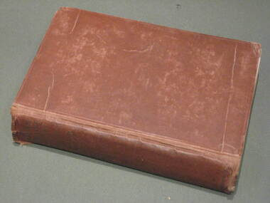
 Warrnambool and District Historical Society Inc.
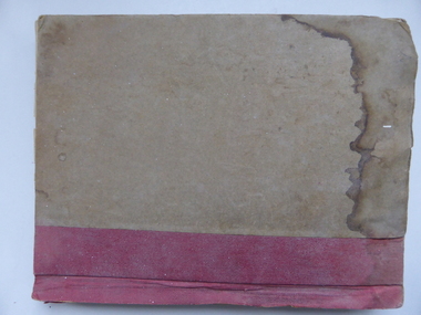
Book, Book Certificate of Titles A-Z Index, C 1890
This book contains certificates of title and Crown grants which record local changes of ownership.many are in the township of Warrnambool while others relate to areas such as Nullawarre, Purnim and Framlingham.These documents come under the Transfer of lands act of 1890.This book has many local names and properties and is an historic link for the district.Brown heavy card cover with red fabric binding. It has an alphabetical index at the front followed by 200 pages of certificates of title.Descriptions of the land is written at the top of the pages with drawn and coloured diagrams below. The dates range from C 1878 to to C 1966. Some are certificate of title and others are Crown Grant. warrnambool, certificate of titles warrnambool 1900 -
 Warrnambool and District Historical Society Inc.
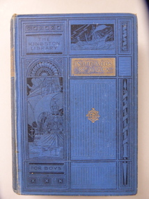
Book, In The Wilds of Africa, 1901
This is a boy’s adventure book owned by Francis Skuse of Strathallan, Allansford in 1906. Francis Skuse, the son of John and Catherine Skuse, was a grazier at the property Strathallan, six kilometres from Allansford. His property included the Strathallan mine which had limestone/carbonates deposits. He died in 1962. This book is of interest because it was owned by Francis Skuse, a farmer and long-time resident of Strathallan, near Allansford.This is a hard cover book of 558 pages. It has a blue cover with the names of the title and author in blue print on a gold background. The front cover and the spine are patterned with scrolls and imprints of sailing ships. The book contains several black and white sketches. The inscription on the first page, with the page partly detached, is handwritten in blue ink. ‘Francis Skuse, Strathallan, Allansford, June 3rd 1906’. francis skuse, strathallan -
 Warrnambool and District Historical Society Inc.
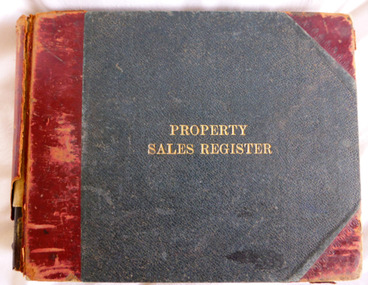
Document - Book, Arnall & Jackson, Printers, lithographers, bookbinders, publishers, manufacturing stationers. 428 Collins St Melbourne, Book Property Sales Register, Circa 1944
This ledger contains listings of purchasers of properties within Warrnambool area during the period 1944 to 1950.This ledger provides a comprehensive list of names and properties in the period 1944 -1950. It lists sales for a number of well -known properties both private and commercial.Dark green hard cover with maroon corners and spine binding. Title is in gold lettering on front cover. Alphabetical index at the front followed by 145 pages of ledger pages. Inside front cover are a number of cuttings from the Warrnambool Standard and the Argus dating from around 1900-1911. Arnall & Jackson**** Lithographers. Printers and manufacturing stationers.warrnambool, property ledger, sales ledger, warrnambool property 1944-1950 -
 Ringwood and District Historical Society
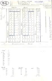
Plan, Plan of Subdivision No.11498 with handwritten costing notations - East Ringwood Central Estate c.1948
Two handwritten pages showing layout of Subdivision no 11498 with surveyor notations including property sizes and road construction cost calculations. Drainage easement 6 feet wide shaded blue.Plan of Subdivision No. 11498, Part of Crown Allotment 27, Parish of Ringwood, County of Mornington, (Certificate of Title Vol 5120 Fol 1023945). Owner Mr Vogel. Subdivision includes Knaith Road, Northwood Street, Langley Street, Bondi Street, and Government Road (later Alexandra Road), Ringwood East. G. Parsons & Sons, Licensed Surveyors, 389 Flinders Lane (Melbourne). -
 Ringwood and District Historical Society
Plan, Ringwood Station Estate, Subdivision, Ringwood, Victoria - circa 1925
ID 5224 note: Further information relating to squares marked H, F, G, J, and K included in ID 5225 - Ringwood Shop and Dwelling Estate.Hand drawn plan of Ringwood Station Estate showing allotments for sale, with two typed pages attached showing land title information and sale prices.Drawn by Edyth Greenwood, phone 988 Central. Subdivision includes Station Street, Pitt Street, Bedford Road, Wantirna Road, James Street, William Street (later Kendall Street), Greenwood Avenue, Ellison Street, and Haig Street. Circles denote blocks for sale. Squares denote house properties for sale. Other features marked include location of businesses along Main Street (Maroondah Highway), cool store, railway station, shop and police station on Bedford Road, church on Station Street, site of schoolmaster's residence and State School, and location of proposed public baths. Ryner & Langford, Solicitors -
 Ringwood and District Historical Society
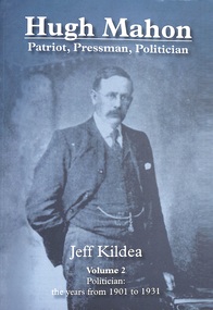
Book, Hugh Mahon, Patriot, Pressman, Politician - Jeff Kildea (Vol 2 1901 to 1931), 2020
Hugh Mahon (1857-1931) was a resident of Ringwood at the time of his death and was buried in Box Hill cemetery.Full title: Hugh Mahon, Patriot, Pressman, Politician by Jeff Kildea - Volume 2: Politician: the years from 1901 to 1931."This book, the second part of a to-volume biography of Mahon, covers the period from his election to parliament in 1901 until his death in 1931. It describes his almost 20 years as a backbencher and a ministe during which he gained a reputation as one of the brainiest men in parliament as well as one of the most controversial. It provides an insight into his reluctant decision to oppose conscription in 1916 and examines in depth his commitment to Irish self-government and the circumstances of his dramatic expulsion from parliament in 1920. The volume also looks at Mahon's career as managing director of the Catholic Church Property Insurance Co. and his intervention in Irish politics dujring the debatge over the Anglo-Irish treaty. It is the story of a flawed genius who simultaneously evoked high praise and damning criticism." -
 Ringwood and District Historical Society
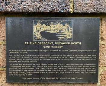
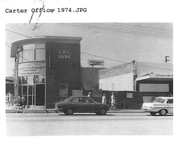
Memorabilia, History of house at 22 Pine Crescent, Ringwood North 1947-1985
Built in 1947 by A.V.Jennings and Co. Lived in for 34 years by Sir Billy and Lady Sneddon.Folder compiled by Richard Carter (C.E. Carter & Sons, RESI) containing various plans, title and notes on the development and extensions to the house, of significance because it was the home of Liberal Parliamentarian and leader of the Liberal Party Sir Billy Snedden.(1926-1987). Built in 1947 by A.V.Jennings for J.M.C. Pratt. Sir Billy and Lady Snedden bought the property in 1963 and Lady Snedden sold it in 1997. -
 Ringwood and District Historical Society
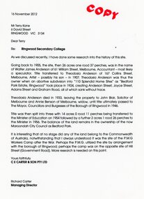
Document - Folder, Brief history of the Ringwood Secondary College site in Bedford Road, Ringwood, Victoria, since 1905 and subdivision in 1924
Terry Kane and Richard Carter were the authors of the short historyType written notes and plans pertaining to the land titles and history of the Ringwood Secondary College site from 1905, prior to the land being sold by the Borough of Ringwood in 1954 to the Education Department. Transcript of covering letter from Richard Carter to Mr T Kane dated 16 November 2012 - "Re: Ringwood Secondary College As we discussed recently, I have done some research into the history of the site. Going back to 1905, the site, then 26 acres one rood 37 perches, was in the name of Walter James Anderson of 61 William Street, Melbourne, Accountant - most likely a speculator. Title transferred to Theodosia Anderson of 167 Collins Street, Melbourne, Artist - possibly his son - In 1907. Theodosia Anderson was thus the owner when on abortive subdivision Into "110 Splendid Home Sites" as "Bedford Park Estate, Ringwood" took place In 1924, creating Anderson Street, Joyce Street, Adams Street and Graham Road, all of which sank without trace. Theodosia Anderson died In 1933, leaving the property to John Blair, Solicitor of Melbourne and Annie Benson of Melbourne, widow, until title ultimately passed to The Mayor, Councillors and Burgesses of the Borough of Ringwood In 1946. Title was then spilt Into three with 14 acres 0 rood 11 perches being transferred to the Minister of Education on 1954 followed by a further 2 acres 1 rood 26 perches to the Minister In 1956. The balance of the land remains In the ownership of the now Maroondoh City Council as Bedford Park. It Is Interesting that at no stage did any of the land belong to the Commonwealth of Australia, notwithstanding that I always understood It was the site of the P.M.G. Workers Camp after the War. Perhaps the P.M.G. utilized the site by arrangement with the borough of Ringwood; perhaps the camp was on the opposite site of Hill Street (Government Road). More research Is needed on this point. Yours faithfully, CE CARTER & SON PTY LTD Richard Carter Managing Director" -
 Ringwood and District Historical Society
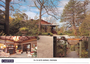
Document, Real Estate History of "Shadowood", 74-76 Alto Avenue, Croydon, Victoria
Folder of Estate Agent's notes compiled in preparation for property auction, 11th October, 2008. Two-page history of "Shadowood", display photo of house with floor plan dating from circa 1920s, copies of LANDATA title documents. Map of Wicklow Hills subdivision, including Alto Avenue, Elesmere Avenue, Glenora Avenue, Wicklow Avenue, and railway line to Lilydale. Title Vol 1323 Fol 264412 Allotment 43C Parish of Warrandyte - Ann McKean, dated 6th October, 1881. Title Vol 1937 Fol 387367 Part of Allotment 43C Parish of Warrandyte - Richard Bonynge Kelly, 11th August, 1887. Title Vol 2728 Fol 543569 Part of Allotment 43C Parish of Warrandyte - Thomas Robertson, 27th July, 1898. Title Vol 4161 Fol 832181 Part of Allotment 43C Parish of Warrandyte - John Gordon Robertson, 4th November, 1918. Title Vol 4490 Fol 897808 Lots 82 and 83, Plan of Subdivision 7478 - Elizabeth Rutherford Morell, 12th August, 1921. Title Vol 4617 Fol 923322 Lot 82, Plan of Subdivision 7478 - Flora Clapperton, 23rd September, 1922. Title Vol 8409 Fol 533, part of Lot 82, Plan of Subdivision 7478 - Hugh Ravenscroft Hastings Wettenhall and Sybella Anne Wettenhall, 1st May, 1962. -
 Ringwood and District Historical Society
Document, Certificate of Title and miscellaneous property records - Carter Real Estate, 122 and 124-128 Maroondah Highway, Ringwood, Victoria
... Certificate of Title and miscellaneous property records... Road Ringwood North melbourne Transfer of Land Act Title dated ...Transfer of Land Act Title dated 24/4/2002 - Volume 10314 Folio 972 Crown Allotments 11H and 11J, Parish of Ringwood, Entitlement Grant to a depth of fifteen metres - 29/1/1997, City of Ringwood planning permit and diagram of office floor plan - 1973. -
 Marysville & District Historical Society
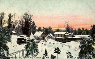
Postcard (Item) - Colour tinted postcard, John William Lindt, The Hermitage on the Black Spur in Winter, 1900s
A digital copy of an early colour tinted postcard of "The Hermitage" in Narbethong in Victoria.A digital copy of an early colour tinted postcard of "The Hermitage" in Narbethong in Victoria. "The Hermitage" was built by photographer John William Lindt as a home and guesthouse in 1894. John Lindt had previously photographed the mountain scenery of the Black Spur and purchased 71 acres and subseqently built his home and guesthouse from where he continued his career. "The Hermitage had a garden designed by John Lindt's friend, Ferdinand von Mueller, who was at one stage the Director of the Melbourne Botanic Gardens. The garden featured New Guinea tree houses from which John Lindt made frequent panoramas of his property and the surrounding forest of towering mountain ash. Aged 81 Lindt died of heart failure during disastrous bushfires on 19 February 1926 at the Hermitage. He was survived by his wife Catherine who continued to run ‘The Hermitage’ guest house before she retired to the city.the hermitage, john william lindt, narbethong, victoria, black spur, ferdinand von mueller, melbourne botanic gardens, new guinea, catherine lindt, winter -
 Marysville & District Historical Society
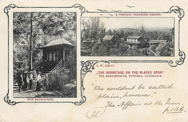
Postcard (Item) - Black and white postcard, John William Lindt, "The Hermitage on the Blacks Spur" via Healesville, Victoria, Australia: A Perfect Pleasure Resort, 1900s
A digital copy of an early black and white postcard of "The Hermitage" at Narbethong in Victoria.A digital copy of an early black and white postcard of "The Hermitage" at Narbethong in Victoria. "The Hermitage" was built by photographer John William Lindt as a home and guesthouse in 1894. John Lindt had previously photographed the mountain scenery of the Black Spur and purchased 71 acres and subseqently built his home and guesthouse from where he continued his career. "The Hermitage had a garden designed by John Lindt's friend, Ferdinand von Mueller, who was at one stage the Director of the Melbourne Botanic Gardens. The garden featured New Guinea tree houses from which John Lindt made frequent panoramas of his property and the surrounding forest of towering mountain ash. Aged 81 Lindt died of heart failure during disastrous bushfires on 19 February 1926 at the Hermitage. He was survived by his wife Catherine who continued to run ‘The Hermitage’ guest house before she retired to the city."She couldnt be called/ plain, however."/ The affair at the Inn./ IS/ p 1 hh.the hermitage, john william lindt, narbethong, victoria, black spur, ferdinand von mueller, melbourne botanic gardens, new guinea, catherine lindt, collotype -
 Glen Eira Historical Society
Article - ELSTER AVENUE, 20, ELSTERNWICK
This file contains 5 items: 1/Handwritten notes of title search details compiled by Peta Darke, dated 25/07/2014. From 1909 to 1936. 2/Photocopy of six pages of handwritten details from title searches compiled by Peta Darke, dated 24/10/2014. From 1871 to 1920. 3/Handwritten list of Sands and McDougal entries from 1915 to 1970 and additional notes up to 2014, compiled by Peta Darke, dated 28/07/2014. 4/Photocopies of four advertisements concerning the property from The Argus as follows: 26/04/1919 page 17: property for sale; 10/05/1919 page 14: property for sale; 01/09/1917 page 13: a son born to Mrs. W. Robertson of ‘Struan’; 09/06/1928 page 2: mortgagee’s auction to be held. 5/Photocopy of colour photography of 20 Elster Avenue taken by R. Darke, approx. 1998.elsternwick, gardenvale, elster avenue, struan, kooyong road, parnell street, college street, lempriere john thompson, hawker lilian margaret, taylor mary maud, davison lily ann, pretty ralph, robinson charles, robinson william henry, robinson george augustus, inglis robert, davies matthew henry, ross william murray, calder william anderson, watson john, rosstown junction railway and property company, muntz street (now parnell street), rupert street, oswald street, peile edgar stoddart, robertson walter, davison walter, bays arthur, gluth william, petersen o. c., farnell thomas h., bennett william, mcdonald michael, donaldson william, ryan james s., diamond g., nirens george, nirens pamela, nirens paul, nirens linda, coburn helen, coburn graham, coburn laura, coburn george, architectural styles, edwardian style, brick houses -
Glen Eira Historical Society
Article - ELSTER AVENUE, 18, ELSTERNWICK
... of two pages of the title to the property dated 22/10/1909... this property: 1/Handwritten notes from titles searches of 18 Elster ...This file contains 5 items about this property: 1/Handwritten notes from titles searches of 18 Elster Avenue complied by Peta Darke dated 29/07/2014 – photocopy 7 pages. 2/Handwritten list of Sands & McDougall entries for 1915 to 1970, and notes to present, compiled by Peta Darke dated 29/07/2014. 3/Photocopy of two pages of the title to the property dated 22/10/1909. Includes plan of subdivision of the area. 4/Photocopies of five advertisements from The Argus relating to the property: 28/08/1918 Land Wanted 12/07/1921 Lost Heifer 26/04/1919 Owner has House For Sale (20 Elster Avenue) 10/05/1919 same – No. 20 For Sale 29/11/1927 M. M. Taylor has Oats and Barley For Sale. 5/Photocopy of photograph of exterior taken by R. Darke circa 1998.elsternwick, gardenvale, elster avenue, robinson charles, caulfield, robinson william henry, robinson george augustus, inglis robert, davies matthew henry, ross william murray, colonial investment and agency company, victorian permanent property investment and building society, calder william anderson, watson john, rosstown junction railway and property company, kooyong road, college street, parnell (muntz) street, lempriere john thomson, thomson william hamilton, collinson william morris, elizabeth street, cumming euphemia, taylor thomas, hill caroline, evans alexander cameron, evans horace, evans gordon lemaitre, roach joyce rubena, evans mary arthur, nallo luigi, nallo joyce, north road, darke richard alexander, darke peta, peile edgar stoddart, corio, darke caroline elizabeth, darke cameron andrew, oswald street, bertram street, taylor m. m., land subdivision, architectural styles, edwardian style, brick houses, teak street, caulfield south -
Glen Eira Historical Society
Article - ELSTER AVENUE, 16, ELSTERNWICK
This file contains 6 items: 1/Handwritten notes by Peta Darke dated 25/07/2014 listing title details for 16 Elster Avenue from 1909 to 2009 – two pages. 2/Handwritten list of Sands and McDougall entries for the property from 1915 to 1940 dated 25/07/2014 compiled by Peta Darke. 3/A photocopy of a Biggin Scott Real Estate Agents flyer advertising the recent sale of the property in 2009. 4/Print out from ‘The Argus’ of 04/12/1917, Page 6, from the Trove website of a brief article concerning the wounding of S.P.Jones, son of Stephen Jones of ‘Mons’, Elster Avenue in November 1917. 5/A photocopy of colour photograph of exterior of 16 Elster Avenue Circa 1998 taken by R.Darke. 6/Article from ‘Caulfield Glen Eira Leader’ of 25/03/2014, Page 3, concerning Oscar Jones, 14 year old son of present owners, who is an excellent surf life saver. Includes colour photograph of Oscar.elster avenue, college street, bowood, elsternwick, bowden arthur william, mons, hartington street, parnell street, jones stephen alma, kooyong road, kendall ann bell, kendall james william, kendall harold duncan, morrison harold lindsay, morrison rhonda may, cook jean isobel, golding ida curnow, perrett craig stuart, perrett eileen mary, perrett edward, perrett anthea, perrett catherine, lewis kay margaret, swain anthony barry gilles, swain darcy, swain mitchell, jones adrian, jones karine stehman, jones oscar, jones patrick, thomas lloyd, rickman jacob, lee james t, nidschelm harold, regan francis, jones douglas, laughton martin, biggin and scott, ashton daniel, jones stephen percy douglas, architectural styles, edwardian style, timber houses, gardenvale, collinson william morris, thomson william hamilton, lempriere john thompson -
Glen Eira Historical Society
Article - Dorothy Avenue, 20, Glen Huntly
This file contains four items about this property: 1/6 pages on history of 20 Dorothy Avenue, 4 pages are photocopied photographs of home exterior and interior. 2/Printout from Museum Victoria website showing model of D C Gallager House Glenhuntly, designed by A V Jennings’ first architect Edgar Gurney. 3/Photocopied article from unknown source about proposals to add another story to their house in 1977/1978. 4/Photocopy of Certificate of Title for 20 Dorothy Avenue, Glenhuntly.d. c. gallager house, glenhuntly, a v jennings, gurney edgar, architects, barnard e. f., dorothy avenue, macgowan avenue, house styles, brick, gallagher dudley chas, glenhuntly road, newsagents, dargie william alexander, artists, martin ernest james, mechanics, marek christine, marek joseph, dargie kathleen, dargie roger, dargie faye, charlestworth ted, quin damien, rooms, architectural features, architectural styles -
 Glen Eira Historical Society
Album - Album page, Booran Road, 30, Circa 1972
... appearing on the property title in 1910. The stable has 12 stalls ...This photograph is part of the Caulfield Historical Album 1972. This album was created in approximately 1972 as part of a project by the Caulfield Historical Society to assist in identifying buildings worthy of preservation. The album is related to a Survey the Caulfield Historical Society developed in collaboration with the National Trust of Australia (Victoria) and Caulfield City Council to identify historic buildings within the City of Caulfield that warranted the protection of a National Trust Classification. Principal photographer thought to be Trevor Hart, member of Caulfield Historical Society. Most photographs were taken between 1966-1972 with a small number of photographs being older and from unknown sources. All photographs are black and white except where stated, with 386 photographs over 198 pages. From Glen Eira Heritage Management Plan 1996 by Andrew Ward: In 1888, John Leek, a trainer, owned Lot 15, measuring one and three quarter acres, in Booran Road, north side between Glen Eira and Neerim Roads. The land backed onto the Caulfield Racecourse Reserve. NAV was £45. In 1890 Leek built for his residence, a ten roomed brick house on the site. NAV was £200. Leek was the owner/trainer of "Ingliston" who won the Caulfield Cup in 1900. Upon the horse's death in 1901, Leek is understood to have defied tradition by spending £20 on boots for the "ragged urchins in Bourke Street" instead of "shouting" at the bar. By 1899, the property was owned and occupied by Alfred Merrill, a dentist and was known as "Andover". NA V had decreased to £ll0. By 1910, Leslie Macdonald, a gentleman had purchased the property and renamed it "Moidart". In 1910-11 Macdonald sold it to John Robertson. The property had extensive wood stables on its north-east boundary and several other outbuildings. The house continued to be described as "Brick, ten rooms" as it was in 1926 when it was owned and occupied by John Arthur, a managing director. The land measured la.2r.31p. and had a NAV of £235. Nine people lived there. In 1926, Arthur also owned the adjoining Lot 16. Other racehorses of note, known to have been stabled here include Sobar, Havelock, Proud, Future and Lord.Victorian Heritage Register https://vhd.heritagecouncil.vic.gov.au/places/13532 What is significant? Lord Lodge is a thoroughbred racehorse training complex adjacent to Caulfield Racecourse, established in 1890. The area immediately around the racecourse has been associated with horse racing activities and businesses servicing the industry since the development of the racecourse in late the 19th century. Lord Lodge was named by the present occupants after the champion racehorse Lord who was stabled there in the 1950s. In the early 20th century the property was known as 'Andover' and subsequently 'Moidart'. The site consists of a single storey brick Italianate villa, jockeys' quarters, stables and open day yards with direct access to Caulfield racecourse from the rear of the property. The villa of 10 rooms on bluestone foundations was constructed in 1890 by John Leek, a horse trainer who purchased the newly subdivided land in 1888. The house has many Victorian Italianate or Boom Style features although it is more modest than many villas of its style. It has an asymmetrical facade with a faceted bay window and a prominent central tower with low pitch pyramidal roof that provides a clear view of the racecourse. Other characteristic features include stilted segmented arches, bracketed eaves, stucco wall finish and cast cement ornamentation. A room has been added on the north-facing verandah in sympathetic style and finish. Internally the rooms are substantially intact with original marble fireplaces and intricate ceiling roses and cornices. An entrance toward the rear of the southern side of the house is said to be where the stable hands, jockeys and other staff lined up for their meals. In the southeast corner of the property, backing directly on to Caulfield racecourse, is a substantial late Victorian timber stable, probably constructed in the 1890s but first appearing on the property title in 1910. The stable has 12 stalls, a loft and brick pavement and jerkin head roof form with varnished pine-lined ceiling carried on a chamfered timber frame. It has an original roof lantern. The doors of the stalls are not the original sliding doors but swing doors obtained from a barn at Epsom Racecourse in Mordialloc prior to demolition. Outside the gambrel roof has fretted barges but the building is otherwise utilitarian. Timber throughout the stalls has been worn by chewing and rubbing of horses over the century of its use. In the southern half of the property are open day yards where the racehorses are kept during the day. The red brick, single storey jockeys' quarters to the rear of the villa were probably built around 1950. A small brick, possibly late Victorian structure on the eastern boundary thought to have originally been a gardening shed, has been converted to a stable of two stalls. Modern concrete brick stables fill the northeast portion of the property. At the front of the property two Moreton Bay Figs (Ficus macrophylla), probably planted in the late 19th century, provide shade for horses in the day yards. In the 1890s John Leek sold the property, relocating his training facility to one of the newly established racecourses at Mentone or Mordialloc (Epsom). By 1899, the property was owned and occupied by Alfred Merrill, a dentist, who named the property 'Andover'. In 1910 it was purchased by Leslie McDonald, a gentleman, and renamed 'Moidart'; sold in 1910-1911 to John Robertson; and again in 1926 to John Arthur, a racehorse owner. The Victorian Amateur Turf Club purchased the property in the late 1930s and since this time has been leased to racehorse trainers. It is unclear whether the property operated as a training facility between 1899 - 1926. Several notable trainers and jockeys are associated with Lord Lodge. The best known is Arthur 'Scobie' Breasley, Australia's most successful jockey who was apprenticed to trainer Pat Quinlan at Lord Lodge (then 'Moidart') from 1928 - 1935. Breasley rode winners of the Caulfield Cup in four successive years 1942-45 and again in 1952. John Leek, the original owner of Lord Lodge trained Ingliston, the 1900 Caulfield Cup winner. Along with 'Lord' a number of well known racehorses including Sobar, Havelock, Proud and Future were trained at Lord Lodge .....Page 40 of Photograph Album with three landscape photographs of the exterior of this house.Handwritten: 30 Booran Road [top right hand corner] / 40 [bottom right]trevor hart, jenny o'donnell, booran road, mansion, caulfield east, ingliston, sobar, havelock, proud, future, lord, andover, moidart, lord lodge, grace darling, caulfield racecourse reserve, victorian amateur turf club, historic buildings register, national estate register, caulfield cup, horses, stables, horse racing, racehorses, outbuildings, racehorse trainers, depression, 1890s, brick houses, mansions, towers, verandahs, stained glass, italianate style, victorian style, architectural features, architectural styles, john leek, leslie macdonald, john arthur, john robertson, alfred merrill, jenny odonnell -
 Glen Eira Historical Society
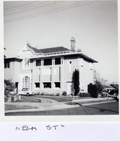
Article - ‘REPTON’, ELM AVENUE, 10, ELSTERNWICK
This file contains six items about this mansion: 1/Three pages of handwritten notes by Peta Darke, dated December 2013, concerning the title and ownership of Repton from 1881 till 2013, earlier called ‘Wahgunyah’ 2/Handwritten list of owners of Repton from various editions of Sands and McDougall Directories compiled by Peta Darke on 06/12/2013 3/Black-and-white photograph of exterior of Repton, undated, photographer unknown 4/Seven copies each of a classified advertisement in The Argus newspaper relating to Repton and its occupiers. Dates are 15/01/1927, 15/12/1928, 07/03/1917, 10/07/1926, 02/07/1940, 10/04/1944, and 28/01/1949 5/Article in Property Review Weekly dated 15/11/2013 advertising forthcoming auction on 30/11/2013. Includes colour photographs of exterior and interior. Also brochure real estate agent advertising forthcoming auction of Repton: includes 4 colour photographs of exterior and interior, description of property and plan of layout. Produced in 2013. 6/Printed information taken from 'Trove' regarding former residents of 'Repton', Elm Street, Elsternwick by Claire Barton. Research is from the Stubss family tree about Dermot Du Moulin Ryan whose mother's address is listed as this property.repton, wahgunyah, elm avenue, elm road, elsternwick, roan andrew, partridge john douglas, partridge alice anna, partridge john roland phelps, phillips ida mary charlotte, steers reuben rivers, mann agnes, gruer william frank, taylor james alexander, marmaras george, marmaras arthur, supported housing, stevens edward, matthews herbert, repton court flats, marmara drive, lehte, fosbery avenue, taylor florence ethel, wood john frances wealth, brick houses, land subdivision, flats, victorian style, stubbs family, ryan dermot du moulin, ryan kate, elm street, house names, ryan h h -
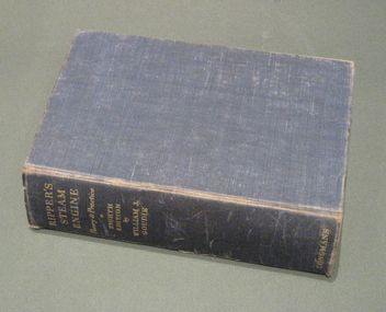
 Federation University Historical Collection
Book, William Ripper, Steam-Engine Theory and Practice, 1914
Used at Ballarat School of MinesThe cover is a red brown colour with the title on the spine and the publisher Longmans & Co printed near base of the spine. The book has 496 illustrations throughout with some pull out plates. Pages 514.On the inside cover it is stamped with The School of Mines Ballarat and written in pencil is 1914 and E K.compound engines, thermodynamics of gases, properties of steam, temperature-entropy diagrams, superheated steam, steam-jacket, feed-water heaters, crank-shaft, flywheels, corliss engine, steam turbine, condensers, friction of engines, steam-engine, william ripper, steam -
 Federation University Historical Collection
Book, William J. Goudie, Ripper's Steam Engine Theory and Practice, 1932
Formerly part of the Ballarat School of Mines libraryA blue book with the title printed in gold on the spine, and the publisher "Longmans" printed in gold at the base of the spine. It has 503 illustrations throughout. It has two loose pages of plates in a sleeve inside the back cover and some pull out plates throughout. 841 pagesIt is stamped with The School of Mines Ballarat near the front and back pages, as well as some throughout the book.steam engine, properties of steam, flywheels, condensers, thermodynamic principles, energy diagrams, engine cycles and efficiencies, brake horse-power, steam in the cylinder, multiple expansion engines, valve gears, governors, crank, corliss and drop-valve engines, steam turbines, turbine performance, steam -
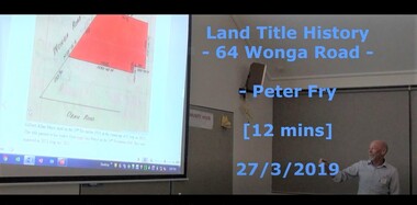 Ringwood and District Historical Society
Mixed media - Video, RDHS Guest Speaker Presentation - "Land Title History, 64 Wonga Road, Ringwood" - Peter Fry
Digitised video (662MB). Duration: 12 minutes. Recorded March, 2019. (Video is available for viewing at Ringwood & District Historical Society Archives by appointment)Presentation: Peter Fry has done quite a bit of tracing of properties in the Ringwood area where he grew up. In this talk, Peter presents an example of his research, covering the house and property now known as 64 Wonga Road, which has a long and interesting history dating back to the early days of orcharding in the district. -
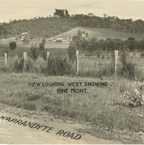 Ringwood and District Historical Society
Document - Property Titles, Transfer of Land Act - "Pinemont", Ringwood, Victoria
... Property Titles ...Folder containing copies of LANDATA documents relating to "Pinemont", Panorama Avenue, Ringwood, Victoria, compiled for potential real estate sales background information purposes. Title Vol 965 Fol 923 Allotment 27B Parish of Warrandyte - James Forbes, dated 30th August, 1876. Title Vol 5236 Fol 1947157 Lots 294 and 370 on Plan of Subdivision no.11392 - Anthony Loughnan, dated 4th March, 1927. Title Vol 6415 Fol 1282937 Lot 294 on Plan of Subdivision no.11392 - Jessie McCracken Rothwell Woodard, dated 9th September, 1940. -
 Ringwood and District Historical Society
Work on paper, Sepia Photogragh of unknown man, on paper in cardboard cylinder with Paris address dated 1903 (In Wieland family collection)
... of the earliest pupils at BayswaterSchool . The title of the property... . The title of the property was transferred to him on his father's ...Ernest Ferdinand Wieland was Carl's son and one of the earliest pupils at BayswaterSchool . The title of the property was transferred to him on his father's death in 1904..Cardboard cylinder with partial Paris address with" boutique de portrait " on it and partial hand written address with "Tasma" just visible.Inside a sepia portrait of possibly Ernest Ferdinand Wieland as a young man. Dated 1903. -
 City of Moorabbin Historical Society (Operating the Box Cottage Museum)
Book, E-Gee Printers Pty.Ltd, Local History : Carrum to Cheltenham, 1999
A small softcover book dark green in colour at the top of the front cover is the authors name written in purple and the book's title written in large red letters there is also a charcoal drawing of a person driving a horse and dray with what looks like sacks of produce in the back on the back cover is text by the author and three reviews by different people.The book also contains a lot of old black and white photos of the family and places of note in the area.cheltenham, kingston, pioneers, moorabbin, carrum, mordialloc, picnic, asylum, hobsons bay, brighton, beach boxes, bridge hotel. -
 City of Moorabbin Historical Society (Operating the Box Cottage Museum)
Photograph - 115 Jasper Road, Bentleigh, Allan / Grewer Estate, c. 1890's
115 Jasper Road, Bentleigh East was a market garden owned by James Allan. In 1880 the property was transferred to David Grewar (Gruar) who had married James' niece Mary Allan. In 1926 part of the land was subdivided and sold as residential blocks. The block with the house pictured remained in the family until 1969. The land now forms part of Our Lady of Sacred Heart College. The description of the land owned by David Kidd Grewer (also spelt Gruar) in 1885: Fourteen acres or thereabouts at the corner of Jasper Road and Patterson’s Road East Brighton being part of Crown Block of 5720 acres Parish of Moorabbin County of Bourke being land comprised in Certificate of Title Volume 1344 Folio 268692 on which is erected a 4 roomed brick house with 2 rooms of wood at the rear and stable and a 2 roomed weatherboard cottage valued as under: 14 acres of land less crops £629.0.0 4 roomed brick house £250.0.0 Other buildings £50.0.0 2 roomed weatherboard cottage £35.0.0 Early pioneer family of the City of Moorabbin.Black and White photo in picture framegrewar, market garden, moorabbin, bentleigh, jasper road, housing, pioneer, james allan, orchard -
 Bendigo Historical Society Inc.
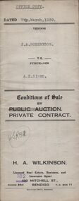
Document - H.A. & S.R. WILKINSON COLLECTION: CONTRACT OF SALE
Conditions of sale by private contract dated 7th March, 1939 between J.A. Robertson (seller) and A.E. Simms (buyer) for land situate Prowse Road, Bendigo, at present occupied by Mrs. Harbour as tenant, being the land described in right to occupy residence area No. 190. Also all the vendor's right, title and interest to the land as fenced adjoining the above mentioned property, together with 5-roomed weatherboard dwelling and all sundry. Price 250 pounds. Attached copy of application to register a Lienorganization, business, h.a. & s.r wilkinson real estate -
 Bendigo Historical Society Inc.
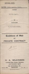
Document - H.A. & S.R. WILKINSON COLLECTION: CONTRACT OF SALE
Conditions of sale by private sale dated 10th April, 1940 between W.V.O. Earl (seller) and C.M.F. Skilbeck (buyer) for land situate No.148 Booth Street, Bendigo, being the land described in right to occupy residence area No.4501. Also all the vendor's right, title and interest in that piece of land adjoining the above mentioned land described in permissive occupancy title no. W.52845, together with 5-roomed weatherboard dwelling and all sundry. Also bath, copper and troughs. Price 175 pounds. Attached Insurance cover issued by The United Insurance Company Ltd for above property. Office copy.organization, business, h.a. & s.r wilkinson real estate -
 Bendigo Historical Society Inc.
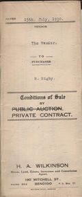
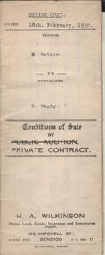
Document - H.A. & S.R. WILKINSON COLLECTION: CONDITION OF SALE
Conditions of sale by private contract dated 15th July, 1930 between H.A. Wilkinson (seller) and R. Rigby (buyer) for land situate Wallan Street, California Gully, being Crown allotment 148 section M described in certificate of title volume 3651 folio 730163, together with 5-roomed weatherboard dwelling and all sundry. Also all vendor's interest in and to the adjoining block of land on the lower side of the above mentioned property. Price 100 pounds.organization, business, h.a. & s.r wilkinson real estate -
 Bendigo Historical Society Inc.
Document - H.A. & S.R. WILKINSON COLLECTION: CONTRACT OF SALE
Conditions of sale by private contract dated 15th July, 1930 between H.A. Wilkinson (seller) and R. Rigby (buyer) for land situate Wallan Street, California Gully, being Crown allotment 148 section M described in certificate of title volume 3651 folio 730163, together with 5-roomed weatherboard dwelling and all sundry. Also all vendor's interest in and to the adjoining block of land on the lower side of the above mentioned property. Price 100 pounds.organization, business, h.a. & s.r wilkinson real estate