Showing 340 items
matching stones family
-
 Kew Historical Society Inc
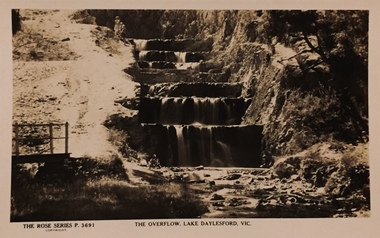
Postcard, The Overflow, Lake Daylesford, Vic
One of a number of 'real photo' and commercial postcards created by or owned by members of the Christian and Washfold families of Kew. The postcards are part of a larger collection of photographs, postcards and publications donated to the collection in May 2021.Sepia postcard of the artificially-created, stone-stepped overflow from Lake Daylesford The Rose Series P. 3691postcards -- daylesford, christian-washfold collection -
 Sunbury Family History and Heritage Society Inc.
Photograph, c 1920s
The 'Meeise' French car is parked outside the former Mechanics Institute Hall in Stawell Street, Sunbury. J Eadie was responsible for the building of the hall in 1885 and the foundation stone was laid by Lady Janet Clarke. The former Shire of Bulla conducted their council meetings in the hall from 1923 until 1956 when new offices were built in Macedon Street. Later the RSL took over occupancy of the hall and it became known as the Memorial Hall. In the early 1970s Stawell Street was cut off to traffic and incorporated into the Village Green.Over the years the Memorial Hall has been the venue for many community events from debutant balls, flower shows, local gatherings, celebrations and markets to name a few.A sepia photograph with a cream border of a tree lined street with a building in the foreground and a vintage car parked outside the building. Tall pine trees are growing behind the fenceline.mechanics institute, shire of bulla -
 Sunbury Family History and Heritage Society Inc.
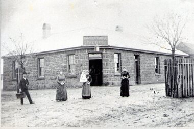
Photograph, Ball Court Hotel
The hotel was built some time shortly after 1842 by John Cahill, who arrived in the colony in 1842 from Thurles in Tipperary, Ireland. The building although much altered with render covering the original \blue stone structure is on the south-west corner of Macedon and Jackson Streets. The hotel was called the Ball Court because Cahill also had a hand-ball court set up behind the hotel.Originally five hotels were built along Macedon Street between Jackson Creek and Evans Street. The Ball Court Hotel is the only one still standing and operating as a hotel.A non-digital black and white photograph with a cream border of man and three ladies standing outside a single story blue stone hotel building with a corner entrance. AS well as the corner entrance there is another doorway on the RHS along with three narrow windows and three other windows on the other side. One of the ladies is holding a little child. Two trees surrounded by tree guards are on each side of the photograph.Ball Court Hotel, John Cahillball court hotel, hotels, sunbury, macedon street, jackson street, ball court -
 Sunbury Family History and Heritage Society Inc.
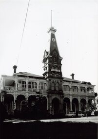
Photograph, Rupertswood Mansion
... was the Sunbury home of the Clarke family. The foundation stone... of the Clarke family. The foundation stone was laid29th August 1874 ...The grand building is Rupertswood Mansion which was the Sunbury home of the Clarke family. The foundation stone was laid29th August 1874 by Mrs. W.J. Clarke the first wife of W.J.Clarke. The property along with the Clarke family have been interwoven with Sunbury's history over the decades and remained in the Clarke family until 1922 when H.V. McKay of Sunshine Harvester fame purchased the property. The Salesian Fathers purchased it in 1927 and since that time the property has been a school. Many important events have taken place in Sunbury within the Rupertswood grounds over the years. A non-digital black and white photograph of a double storey grand mansion with a return verandah on the ground floor and a balcony with decorative iron lace across the front. An elegant tower is over the main entrance.rupertswood estate, rupertswood mansion, w.j.clarke -
 Sunbury Family History and Heritage Society Inc.
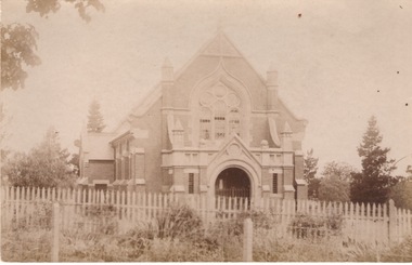
Photograph, St. Andrew's Presbyterian Church
The Government first granted land for the building of a Presbyterian Church in Sunbury in Stawell Street and Barkly Street, in 1864 and a smaller building was later erected on the site. In 1904 Rev Goyen pressed for a brick church rep[lace the smaller weather board building and the foundation stone was laid for the new church was laid by Mrs. John Duncan on 17th August 1904 and the new church opened by Lady Clarke on 13th November 1904.The Presbyterian Church was one of the earliest churches to be established in Sunbury along with a school.A non-digital sepia photograph in post card format of the front view of a brick church with a light picket fence across the front. -
 Sunbury Family History and Heritage Society Inc.
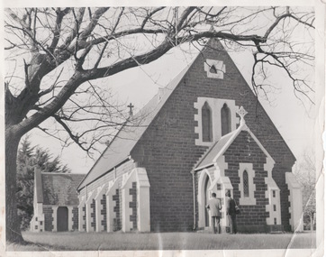
Photograph, St. Mary's Anglican Church - Sunbury
Contextual information relating to St.Mary's Church is entered on P0877. This image was used for a newspaper article An enlarged non-digital black and white photograph with a cream border of a blue stone church with white rendered columns around the windows and door and a pitched slate roof. Two men are standing beside the porch and the vestry is visible at the rear of the main building. A bare deciduous tree is on the LHS of the image -
 Sunbury Family History and Heritage Society Inc.
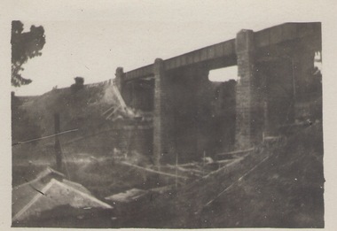
Photograph, Bulla Bridge, 12 July 1944
The photograph was taken looking across the Deep Creek valley with the three-arched stone bridge spanning the river.A black and white photograph with a white border of a deep river valley with a three-arched bridge spanning a river. A gum tree is in the foreground. -
 Sunbury Family History and Heritage Society Inc.
Photograph, Rupertswood Viaduct
The stone bridge is one of the many bridges built along the Bendigo Rail Line. This one along with four others ar in Sunbury which were built in the late 1850s. his bridge spans the Ruoertswood Viaduct which is north of the Sunbury Station. The building in the LH corner was a pump house where water was pumped and taken to the water tower on Sunbury Station where the steam trains stopped to replenish the water tanks. The Bendigo Rail Line was the first Government owned and operated to be constructed in Victoria. Along the railway a number of famous bridges and tunnels were built and are of historical significance. The bridge spanning the Rupertswood Viaduct is one of them. A black and white photograph with a cream border of a high bridge spanning a deep valley. The roof of a small building is visible in the bottom LHS corner of the photograph.bridges, railways, rupertswood viaduct -
 Sunbury Family History and Heritage Society Inc.
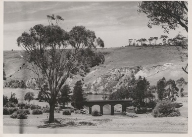
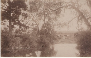
Photograph
The Jacksons Creek and the Macedon Street stone arched bridge are the features in this postcard with a view of a vineyard on the LH river bank. The wine industry was one of the early industries caroused out in Sunbury by the early European settlers in the district.A sepia photograph in post card format of a waterway with overhanging trees and an arched bridge in the middl;e distance.JACKSONS CREEK, SUNBURYjacksons creek, macedon street bridge, vineyards. -
 Sunbury Family History and Heritage Society Inc.
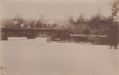
Photograph
The post card is a record of a time when the Jacksons Creek flooded and the water almost reached the two arches on the Macedon Street Bridge. The Goonawarra Winery buildings can be seen in the back ground.A sepia photograph in post card format of a river in flood with the water almost reaching the two arches on the stone bridge. Farm buildings can be seen in the middle distance.JACKSON'S CREEK IN FLOOD SUNBURYmacedon street bridge, jacksons creek, goonawarra winery -
 Sunbury Family History and Heritage Society Inc.
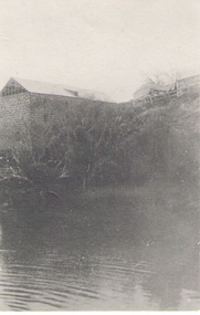
Photograph
The large building is a former mill which was sited along the Jacksons Creek in Sunbury.Milling along with vineyards was one of the early agricultural pursuits carried out in the former Bulla Bulla district.A black and white photograph of a large stone building built on a rise above a pond.jacksons creek, mills -
 Sunbury Family History and Heritage Society Inc.
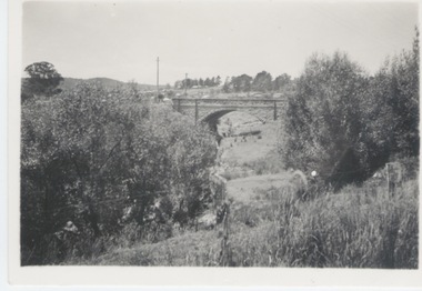
Photograph
The single span bluestone bridge is on the Calder Highway at the base of Corkscrew Hill between Gap Road and the town of Gisborne. In the early 1990s the highway was widened and dual carriageways constructed, as a result the traffic no longer travelled along the winding Corkscrew Hill road. The bridge still stands between the two carriageways. A black and white photograph with a cream border of a single arched stone bridge spanning a watercourse. Small bushes are growing in the foreground and there are some buildings dotted across the hill in the middle distance.bridges, corkscrew hill, calder highway -
 Sunbury Family History and Heritage Society Inc.
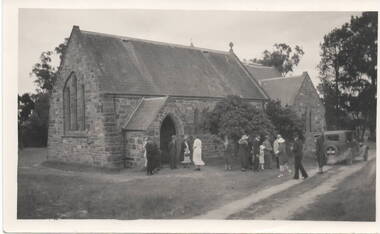
Photograph, c 1930s
St. Mary's Anglican Church at Bulla originally occupied a site along Oaklands Road, adjacent to 'Woodlands' homestead. It was established in 1859. With there building of the Melbourne Airport at Tullamarine it was found that the church on its existing site was directly under the flight path of the aircraft so the building was demolished stone by stone and rebuilt in the Bulla township adjacent to the Alistair Clark Rose Garden. The original site has not been developed because some early graves are there.St. Mary's Church at Bulla is one of the earliest to be established in the Bulla district. Its mother church, St Pauls Church of England at the original Broadmeadows township was established in 1850 and it still stands and operates on its original site.A black and white photograph with a cream border of a stone church with the congregation members entering the church. A saloon car is parked near the church.st. mary's church of england, bulla., churches. -
 Surrey Hills Historical Society Collection
Photograph, 11 York Street, Mont Albert, May 1974 (2), 1974
This is the home of Ernest Lance Young and Beryl Mair and the childhood home of their children Barbara, Ken and Laurie. Lance was born 24 March 1915 in Surrey Hills, the son of Ernest Augustus Young and Ruby Nichell Whitty. He married Beryl Mair in 1939 and died on 5 October 1999 at Mont Albert. Electoral rolls list him as a manufacturer. His address after marriage was 11 York Street, Mont Albert. He is buried in Box Hill Cemetery (M-*-0867) along with his father. He served in WW2 (Service Number - VX104733 enlisting at St Kilda) and after returning took over his father's business. The Mair family were resident in Barton Street for several generations. Beryl's father Dave Mair was a keen sportsman and founder of the Kangaroo Social Club of cricketers. This is part of a large collection relating to the Mair, Deakin and Young families. Colour photo of the street view of 11 York Street, Mont Albert. Taken from across the street, it shows only part of the gable of the house. The house is heavily screened by a mature garden with several large trees or shrubs. The fence is low and constructed from roughly faced stone.In blue biro on rear: "11 YORK ST / MONT ALBERT" and separately "May 74" ken young, barbara young, laurie young, laurie newton, beryl mair, ernest lance young, lance young, york street, mont albert -
 Federation University Art Collection
Work on paper - Digital Prints, Gilson, Deanne, 'Wadawurrung Axe Heads 1-4' by Deanne Gilson, 2011
Dr Deanne GILSON (1967- ) Country: Wadawurrung Deanne Gilson is a Federation University alumni, and an award-winning multi-disciplinary artist. Her practice draws its inspiration from ‘Ancestral marks’ and design on cultural objects found in museum archives and family oral histories. Deanne’s practice seeks to interrogate the colonial legacy of settlement and the western hegemonic systems of class, race and representation in historical photographs that were imposed on her Ancestors. Her work also explores the matriarchal role through her feminist perspectives, looking at the history of marriage and the oppressive function it has played within her family. Deanne has completed the following educationala achievements. 2014 – 2015 Masters by Research (Visual Art), Deakin University Geelong 2013 Graduate Diploma in Education Secondary, Federation University 2011 Certificate IV in Aboriginal Contemporary Art & Craft 2010 Cultural Heritage Management Course, Lakes Entrance 1 Week 2007 – 2010 Graduated, Bachelor of Visual Arts with Honours, University of Ballarat 1984 Diploma of Art, School of Mines & Industries TAFE This item is part of the Federation University Art Collection. The Art Collection features over 2000 works and was listed as a 'Ballarat Treasure' in 2007.This work depicts an axehead found on Wadawurrung country and is a responce to workign alongside archeologists untertaking land surveys of her ancestral lands and the visual documentaiton of artefcts.art, artwork, deanne gilson, gilson, wadawurrung, stone axe, aboriginal, alumni -
 Port Fairy Historical Society Museum and Archives
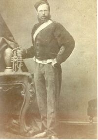
Photograph, Bowyer, Samuel
Samuel came to Belfast with his parents Benjamin and Maryanne on the ship 'Oithona' arriving at Portland on January 30th 1855 when he was 11 years old. In 1865 he marries Selina Ann Daughter of William and Mary Oaff who arrived in Australia on the 'Clara' on the same day as Samuel. They had 6 children. As a stonemason by trade It is probable that he helped his father build the wall around the Consolidated school in 1875. They lived in a stone cottage next door to the Port Fairy Hospital. It was demolished when the new wing was built in 1976. He joined the Manchester Order of Oddfellows in 1863 and was elected Grand Master in 1880. He died when he was 37 in 1881.Early settlerPosed portrait black & white photographpioneer, settler, portrait, people, family, bowyer, samuel, stonemason, clara, oithona, selina ann, william oaff, mary oaff -
 Falls Creek Historical Society
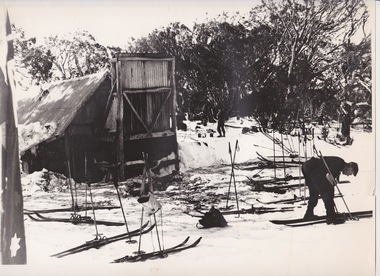
Photograph - At Wallace' s Hut
Wallace's Hut is the oldest surviving cattlemen's hut on the High Plains, built in 1889 by the three Wallace brothers - Arthur, William and Stewart. Their father David bought land at Kergunyah as well as grazing land on the banks of the Kiewa River, North East Victoria. Once the boys were old enough, the family followed the local squatters’ custom of taking their cattle up to the mountains for the spring and summer to fatten the mob, at the same time resting their home pastures. They decided to build a hut where they could shelter from the extreme mountain weather. The timber was cut from the forest about four hundred metres east of the hut, and the hearth stone was dragged in from Pretty Valley. The chimney had a base of rubble and above this iron sheeting on a timber frame. The slab walls were lined with hessian and later with tar-paper, and inside there was a bush table, sleeping platform and a rustic fire-side settle. The hut nestled among snow gums sheltered by a rocky outcrop. The names of the Wallace brothers were burnt into the tie-beams of the roof and at the back of the mantelpiece. The Wallace family’s lease expired in the late 1930s and the hut was bought by the State Electricity Commission to house staff on the High Plains and it became the first home of Toni and Skippy St. Elmo. The SEC covered the old shingles with iron, and later on the walls and chimney as well, and they added a lean-to. Wallace’s Hut is now owned by the Crown and maintained by Parks Victoria. It is on the Historic Buildings Register and is classified by the National Trust.This image is significant because it depicts an important heritage-listed structure and refuge for cattlemen and other travellers in Victoria's High Country.A black and white photograph of a skier outside of Wallace's Hut. Several sets of skis and poles are standing around and other skiers are in the background.wallace's hut, toni and skippy st. elmo, high country huts -
 City of Greater Bendigo - Civic Collection
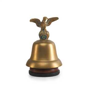
Ceremonial object - Eaglehawk Bell, unknown
The Borough of Eaglehawk was a local government area which covered the northwestern suburbs of the regional city of Bendigo and covered an area of 14.54 square kilometres (5.6 sq mi). Eaglehawk was first incorporated as a borough on 29 July 1862. It had nine councillors, who represented the entire borough. Councillors met at the Town Hall (incorporating the Star Cinema) at the intersection of Sailors Gully Road and Loddon Valley Highway, Eaglehawk. The Town hall has always been the centre of the Borough's activities and was built in 1901 on the site of an earlier town hall which had stood on the location since 1865. The Victorian Heritage Database notes: "The present building replaced this earlier building and was opened on 14 August 1901. The architects were the Melbourne firm of Wilkinson and Permewan. As a much larger and more sumptuous building of brick and stone featuring a central clock tower, the new hall reflected prevailing architectural fashion and was a remarkable investment for a town consisting predominantly of poor mining families. The condition of the town hall is substantially as built. The design is almost identical to the Castlemaine Town Hall." On 7 April 1994, the Borough of Eaglehawk was abolished, and along with the City of Bendigo, the Rural City of Marong and the Shires of Huntly and Strathfieldsaye, was merged into the newly created City of Greater Bendigo.Brass bell with eaglehawk topper / handle on timber stand. The lower front section of the topper has the Borough of Eaglehawk seal attached. No hallmarks or makers stamps visible.borough of eaglehawk, star cinema -
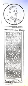 Melton City Libraries
Newspaper, Melbourne A.A. Club, 1903
"Captain Simon Thomas Staughton was the son of Simon Thomas Staughton MLA who had built the mansion Eynesbury on his share of the Exford property inherited from his father Simon Staughton, the original 1840s Werribee River squatter. When the land was sold, Simon’s Exford station extended from Mt Cotterell to the Brisbane Ranges. ST Staughton (senior) was a reputedly the public spirited member of the family in his generation, being a member of the first Roads Board (and Melton Shire President in 1867), a JP, Magistrate and MLA for Bourke from 1883 until his death in 1901, whereupon his son became the MLA for Bourke. Captain ST Staughton had earlier been chosen as a member of a contingent of Victorian Mounted Riflemen sent to England for Queen Victoria’s Diamond Jubilee (1897), and was later a member of King Edward’s coronation escort. In October 1899 he had sailed for South Africa with other Mounted Riflemen from Victorian and NSW to take part in the Boer War. There he was awarded the DSO. He died of peritonitis in 1903, aged 27. He was buried in Boroondara Cemetery after a full military funeral, in which the coffin was borne on a gun carriage drawn by four black horses. All local newspapers reported eloquently on the funeral, and the late Captain’s virtues. The Staughton Memorial Lamp was given to the town by his young widow in 1903. In addition a window in the (former) Christ Church bore the inscription ‘This window is erected by his brother soldiers in loving memory of Captain S Tom Staughton, DSO, ADC, MLA’. The Staughton family had been prominent benefactors of the Church, whose altar rails were also inscribed to the much respected Captain, along with a memorial stone in the new chancel. In the 1970s the memorial was within one of four fenced tree plantations, probably erected and planted in the 1920s or 30s. When High Street and its service roads were redesigned in the 1970s the plantations were completely removed, and the Melton and District Historical Society was successful in having the memorial moved about 50 metres east to its present location". The Weekly Times article about a gift from Tom Staughtonlocal identities -
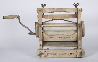 Bacchus Marsh & District Historical Society
Domestic object, Clothes Ace Wringer
Clothes wringer used in the James Young owned house known as the Stone Villa, Bennett Street, Bacchus Marsh. Wringers, also called mangles were used to squeeze water from washed clothes.James Young was a prominent early resident of Bacchus Marsh from the 1850s until the 1870s. This object which was recovered from his house in Bennett Street is indicative of laundry equipment that many moderately affluent households would have owned in the 1860s.Clothes wringer or clothes mangle. Wood and metal components. Clothes Ace Wringer; Warranted 3 years for family use; Superior to Iron Clampsjames young, laundry equipment -
![Memorial Plaque [ Dead Man's Penny], Henry Tippett WW1 Service number 4928](/media/collectors/5aa8674621ea671160a40f59/items/5ab1cd4921ea711918cf4d01/item-media/5ab1d04c21ea711918db1a21/item-fit-380x285.jpg) Camberwell RSL Sub-Branch
Camberwell RSL Sub-BranchMemorial Plaque [ Dead Man's Penny], Henry Tippett WW1 Service number 4928
Memorial Plaque given to the family of Henry Tippett, killed in Action in France 26 July 1916. Henry enlisted when he was 28 years old on the 6 September 1915 in Melbourne. He was born in Carlton and was living at 529 Canning St. Carlton when he enlisted. A small man at 5'.5'' weighing 9 stone. He was allotted to the 15th Refits of the 7th Battalion. He embarked from Melbourne on the 18 June 1916 on the Kinfaune Castle and landed at Alexandria, On the 29 June 1916.he was transported to Marseilles and one moth later was reported Missing in Action on the 28 July 1916, A court of enquiry concluded he was Killed in Action on the 19 July 1916. He had been in France just 20 daysInscribed with the name Henry Tippett. The plaque was presented on the 4 October 1922. His father William could not attend in person and a Donald Tippett was authorised to pick up the plaque by his mother Eliza Tippett. The plaque number is 319981.His mother Eliza Tippett was granted a pension of one pound per fortnight from the 8th November 1916 -
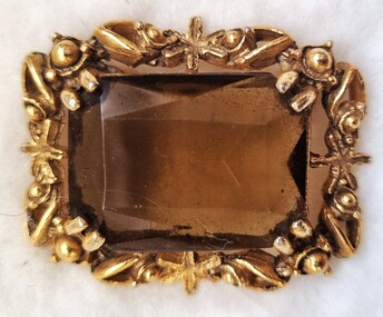 Wodonga & District Historical Society Inc
Decorative object - Brooch
... Family Wodonga Pearce Family Wodonga An amber stone set ...This brooch was owned by Lily Cave nee Stevenson. Lilian Bernice Stevenson was born in Wodonga on 30 November 1920 to John Stevenson and Ivy Victoria nee Pearce. On 28 November 1942, LIlian married Robert Walter Nation in Wodonga. Ivy was related to several prominent Wodonga families, including the Uhe and Heckendorf families. Ivy moved from Wodonga after her marriage. She passed away in Melbourne, Victoria in 2000.This item is connected to a prominent family in Wodonga, VictoriaAn amber stone set in a square gold setting with a pin clasp on the back.wodonga families, stevenson family wodonga, pearce family wodonga -
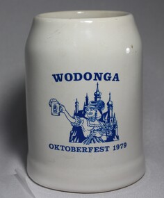 Wodonga & District Historical Society Inc
Memorabilia - Wodonga Oktoberfest Stein, c1979
Several German families arrived in Wodonga, usually via South Australia, in the late 1850 and 1860s. Some of the earliest settlers to arrive were the Haeusler, Schlink, Trudewind, Pfeiffer and Klinge families. Many of them had left from Prussia and Bavaria to escape religious persecution. They all became actively involved in the community and made outstanding and lasting contributions to the development of the town. In the years 1868-69 more settlers arrived from South Australia and other parts of Victoria. Among the names were Heckendorf, Mueller, Zeinert and Schubert. These families were instrumental in lobbying for the establishment of the St. John's Lutheran Church in Wodonga, the foundation stone being laid in 1874. By the 1890s to the early 1900s many other Germany names were added to the local community including Muller, Lange, Pumpa, Greschke, Lobbe, Posselt, Kreuger, Schuster, Pertzel, Star, Draper, Mueller, Semmler, Thiele, Terlich, Wegener, Schreiber and Draper. Germans continued to arrive in the area until 1914. In the great post-war migration that started through Bonegilla in December 1947, Germans were among the tens of thousands who arrived. Most of the migrants who settled in Wodonga at this time were born in Germany. According to the 2016 Census, Wodonga still has a larger percentage of people with German ancestry than most other rural communities in Victoria. The German Austrian Australian Club, Wodonga was originally formed in 1960 by immigrants to Australia, to provide a meeting place for refugees and immigrants from Europe. Oktoberfest has become a world-wide occasion for all people to share in the celebration of Bavarian traditions. The Wodonga Hospital approached the Club and asked for their involvement in holding an Oktoberfest to raise funds for the Hospital. These Fests took 11 months to organize and ended up raising over $27,000.00 for the Hospital. A large number of families of German origin have arrived in the Wodonga area from as early as the 1850s. They have made valuable and lasting contributions to the area in a range of fields including agriculture, local government, businesses, retail and medical services. Their contributions are recognised in several street names in Wodonga. A white china beer stein bearing the blue logo of the Wodonga 1979 Oktoberfest. Logo includes an image of a woman in German national costume.Above the image "WODONGA" Underneath the image "OKTOBERFEST 1979"wodonga, oktoberfest, german immigrants -
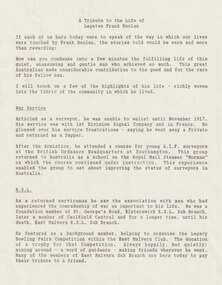 Melbourne Legacy
Document - Eulogy, A tribute to Legatee Frank Doolan
Information on the life of Legatee Frank Doolan from the memorial service held for him in 1988. Legatee Doolan was a very active Legatee, starting within the first year of Legacy when he was nominated by Bill Laver and Charles Copp in 1924. While he never sought 'office but he was always there - in the background - able and willing to actively serve'. In World War 1 he enlisted in November 1917 and served with 1st Division Signal Company and in France. After Armistice he attended a course for young AIF surveyors at the British Ordnance Headquarters at South Hampton. Famously it was Frank that proposed that the spirit of Legacy is service to the widows and children. "Here it received its soul. The thoughts transmitted to the Board by this quiet man." He was part of the Legacy team who worked enthusiastically for the establishment of the Shrine. It was his technical skill as a surveyor that enabled the ray of light to shine on the Stone of Remembrance at 11 am on 11th November. Also to solve the complication of daylight saving by positioning two mirrors . For this he was awarded the British Empire Medal. He was involved in the purchase of Legacy House in 1955 and also in the Lone Pine project in 1964. In a final story the speaker mentions Frank acquired a race horse called Tamwill from the estate of a mate. It gave him great pleasure for years and poignantly died the day before Frank passed away. The card sent as a thank you from the family includes hand written text to Wendy (Faulkner, staff member at Legacy) from Geoff Doolan, son of legatee Frank Doolan. The information was part of an album of past presidents from 1965 to 1989. The folder included biographical details and obituaries, eulogies and death notices of prominent Legatees. The items have been catalogued separately.Part of the collection of material held by Melbourne Legacy on Legatee Frank Doolan a prominent member of Legacy. The information was collected to record the lives of prominent legatees in a folder.Typed A4 document x 5 pages of the life of Legatee Frank Doolan. Pus a memorial card from the family.eulogy, frank doolan, ray of light, shrine of remembrance, lone pine -
 Ballarat Heritage Services
Photograph - War Memorial, L.J. Gervasoni, Ballarat Prisoner of War Memorial, 2006, 12/09/2006
The Ballarat Prisoner of War Memorial was dedicated on 06 February 2004 t acknowledge the pain and suffering that all Prisoners of War endured during their time in captivity, to commemorate the thousands of mates left behind and to acknowledge the sacrifice of families during wartime. The memorial was designed by sculptor Peter Blizzard and is made of natural stone-basalt and granite. 55,000 names are etched onto the 130 metre long granite wall.Photograph of the Ballarat Prisoner of War Memorial ballarat prisoner of war memorial, peter blizzard, pow -
 Flagstaff Hill Maritime Museum and Village
Photograph - Scene - Warrnambool, C. 1854-1871
This is an image of the Warrnambool Lighthouse Complex on Middle Island in 1854. The Store, Lighthouse Keeper's Quarters, Lighthouse and Flagstaff are in the background. The foreground shows a covered buggy drawn by two horses and a person in attendance, and another wheeled vehicle behind it with a figure nearby. There is a saddled horse to the right with two males in conversation nearby. The ground is soft, perhaps the riverbed or sandy shore. THE LIGHTHOUSE KEEPERS Lighthouse Keepers were responsible for keeping their Lighthouse’s lights shining at night. They kept a lookout for passing vessels and changes in weather. They were expected to clean, polish and maintain the equipment and buildings. They kept regular and detailed records of who was on watch, and the time the light was lit, trimmed and extinguished. They kept a journal about other events that occurred. They keep regular, accurate Meteorological Logs. It was expected that they were competent in Morse code signalling. They would be called to help in times of disasters and shipwrecks and to give official statements about these events. Many Lighthouse Keepers also volunteered as members of the lifeboat crew. The Lady Bay lighthouses were officially classified as small, so the Keepers had the official titles of Senior Assistant Lighthouse Keeper and Assistant Lighthouse Keeper. They were employed by the Public Service and paid rent to live in the Lighthouse Quarters. They were compulsorily retired at the age of 60, with most receiving a superannuation payment. Despite their time-consuming duties, there was time to follow hobbies and crafts such as growing vegetables, playing musical instruments, making models of buildings including lighthouses, and crafting furniture pieces. An example of a keeper’s skills is the carved fire screen made by /assistant Keeper Thomas Hope in the late 19th century and displayed in the Lighthouse Keeper’s cottage at Flagstaff Hill. Both Alexander and Farncombe had served under Senior Keeper Robert Deverell, who was the first and only Senior Lighthouse Keeper at the Middle Island Complex. John Alexander was the Assistant Keeper in the 1850s. Andrew Farncombe was the last Assistant Keeper at Middle Island, serving there with his family from 1864 to 1871. During 1871 and 1872 the Lighthouse Complex was moved to Flagstaff Hill on Merri Street. Farncombe and Deverell then became the first Keepers and occupants of the Lady Bay Lighthouse Complex at Flagstaff Hill. They continued their service together; overall, Deverell served from 1859 to 1885 and Farncombe from 1864 to 1974. WARRNAMBOOL'S LADY BAY LIGHTHOUSE COMPLEX - The original Lighthouse Complex was built on Middle Island in 1858-1859 then transferred stone-by-stone to Flagstaff Hill in 1871. The Complex comprised the Lighthouse, the Lighthouse Keepers’ Quarters and a Privy. The bluestone Keeper’s Quarters was a cottage divided into two compartments, one for the Senior Keeper and his family, the other for the Assistant Keeper and his family. The bluestone Store was divided into three; a store, a workshop, and an oil store (or office). The Privy comprised a small building also divided into two separate, back-to-back toilets, one for each Keeper and his family. In the 1970s the Flagstaff Hill Planning Board was set up under the chairmanship of John Lindsay. The Board was to make recommendations to the Warrnambool City Council regarding the use of the buildings and the rest of the Crown Land on the site. The Flagstaff Hill Maritime Village opened in 1975 and began renovating the Cottage in stages, during which time evidence of a 1920s fire was found in the eastern section of the cottage. Additions of a porch on the west and a washroom on the east were made in the 1980s. The western part of the building is now a Shipwreck Museum and the east has returned to a late 19th-century Lighthouse Keeper’s cottage and includes the screen made by Assistant Lighthouse Keeper Thomas Hope in the late 19th century. Hope served two periods of time at the Lighthouse. This photograph is significant as a visual record of the original Warrnambool Lighthouse Complex on Middle Island, the origin of what is now the Lady Bay Lighthouse Complex. The photograph is significant for its connection to the Complex, which is now listed on the Victorian Heritage Register, H1520, for being of historical, scientific (technological) and architectural significance to the State of Victoria. The Complex is significant as an example of early colonial development. The photograph is significant for its connection with the important navigational function of the Lighthouses, a function still being performed to this day. The photograph is also significant as it shows an example of buildings organised by the Public Works Department in Victoria in the mid-to-late 19th century. The structures tare still stand strong. Photograph of horses, a buggy and three gentlemen in the foreground and the background shows a lighthouse and accompanying buildings. Printed in black and white. (Another two horse-drawn vehicles are partially visible). The subject is the Lighthouse Complex on Middle Island, Warrnambool, dated between 1854 and 1871.An inscription is handwritten in black pen on the back of the mounting board."The lighthouse and accompanying buildings were / established on Middle Island in 1854, as this / picture shows. In 1871 they were moved to their / present site on Flagstaff Hill."flagstaff hill, flagstaff hill maritime museum, flagstaff hill maritime village, warrnambool, maritime museum, shipwreck coast, lighthouse keeper's cottage, lighthouse residence, lighthouse, chart room, quarters, privy, middle island, beach lighthouse, obelisk, lighthouse complex, lady bay complex, warrnambool port, warrnambool harbour, lady bay, keepers, lighthouse keeper, upper lighthouse, lower lighthouse, assistant keeper, ports and harbours, cottage, meteorological record, 1854, 1871 -
Bendigo Historical Society Inc.
Document - Samson's Cottage Significance Assessment, 1967
The first, two-roomed, stage of the present cottage appears to have been commenced before 1866, when the first rate notice appeared (Shire of Marong) and possibly as early as the mid-1850s, when the first owner, Thomas Samson, a shoemaker turned joiner, came to the Bendigo goldfields. Samson took up a miner's right in Spec(k) Gully in the mid-1850s. The Samson family had ten children and as the family grew they extended the cottage in stages. Samson worked as a miner until about 1871, then returned to boot making from a weatherboard shed on the property. He opened a shop on the corner of Booth and McKenzie Streets in partnership with John Shocker in 1889. He died in 1893. His wife Sarah remained in the cottage until 1906. Albert and Florence Doye purchased the site in 1908 and the family lived there until 1966. The property has remained in the hands of the family, mostly unoccupied. It was renovated by a tenant in the 1970s and passed from miner's right to freehold in 1974. It is currently owned by Arthur Doye, who lives nearby, and is unoccupied. During its early life it, probably during the Samson occupation, it was altered and extended many times into a complex arrangement of structures and outbuildings. Stone remained the dominant building material throughout, even for the poultry shedsThree page report on the significance of Sansom's Cottage, 21 Doye Street, Golden Square, Bendigo. Topics include what is significant; why is it significant; permit exemptions; assessment against criteria; extent of registration and contextual history. Final page on 'history of place' is missing from document.sansom cottage, golden square, heritage register, sandstone, miner, shoemaker, thomas sansom -
 Bacchus Marsh & District Historical Society
Map, Subdivision of the Manor House Property Bacchus Marsh c.1908
This land sales plan shows allotments of land offered for sale in the inner township area of Bacchus Marsh in 1908. The land put up for sale was from the estate of the late Mr and Mrs J.E. Crook. That being James Elijah Crook and his wife Harriet, (nee Athorn). The Crooks had been resident in Bacchus Marsh since the 1840s and were prominent members of the community. They were prominent in the business, social and civic affairs of the town and district. In the 1850s the Crooks acquired the Manor House and nearby land once owned by the Bacchus family. James Crook died in 1889. When Harriet Crook died in February 1908 their estate was offered for sale. This included the large stone home known as the Manor House and various parcels of land including around 50 allotments of land near the Manor House, bounded by Young, Lerderderg, Crook and Main Streets. Most of these allotments of land were sold in October 1908. The Manor House itself was passed in at the sale and continued to be owned by the Crook family for several decades after 1908.A single page map on a single page of a bound volume of maps. The map shows portions of land for sale from the subdivision of the Manor House property in Bacchus Marsh in 1908. The names of most of the buyers of the portions of land have been hand-written into the various allotments they purchased. The maps are pasted into a bound volume containing 76 maps or plans in total. High resolution digital image stored on BMDHS computer network. bacchus marsh victoria maps, land sales bacchus marsh, manor house bacchus marsh, crook family bacchus marsh -
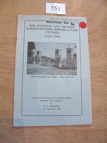 Stawell Historical Society Inc
Book, N.A. McLennan, The Founders and Records, Marnoo Soldiers Memorial Park Victoria 1919 - 1965 by N A McLellan, 1965
About the founding of the Marnoo Soldiers' Park. THe Meaning of Marnoo, where Is Marnoo?, and the People involved.Pale blue Card with black Border inside of which is black text and b/w of a iron gate and four stone pillars.The Founders and records Marnoo Soldiers' Memorial Park Victoria 1919 -1995 Marnoo Memorial Park Gates Photo Taken 1963 Complied and written for the Marnoo Soldiers' Park Committee. by N.A. McLennan 9th September, 1965stawell ww1 ww2, mclennan family -
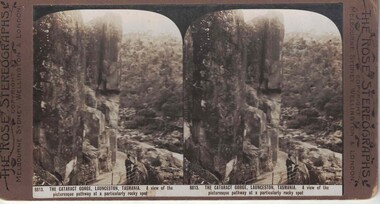 Linton and District Historical Society Inc
Stereograph, The Rose Stereographs, Melbourne, Sydney, Wellington and London, 8813. The Cataract George, Launceston, Tasmania, Copyright 19
One of two sets of stereographs donated by the O'Beirne family along with a stereoscope for viewing (Stereoscope is Registration no. 2014-51).Stereograph of two black and white images. A man is standing at a railing along a path. High stone wall behind him and natural bush in the foreground.8813. THE CATARACT GORGE, LAUNCESTON, TASMANIA. A view of the / picturesque pathway at a particularly rocky spot.stereographs