Showing 288 items matching "warrnambool maps"
-
 Warrnambool and District Historical Society Inc.
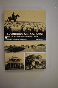
Book, StarPrinting Service Pty ltd, Soldiering On – Caramut and the Soldier Settler Movement, 2018
This book records the history of the post World War Two soldier settlement farms in the Caramut area. Number two in a series of books on Soldier Settlements in Western Victoria.This is a soft cover book of 315 pages. It has a buff-coloured cover with black and white photographs and white printing on the front cover and black printing on the spine. The book includes printed material, black and white photographs, maps and plans. non-fiction This book records the history of the post World War Two soldier settlement farms in the Caramut area. Number two in a series of books on Soldier Settlements in Western Victoria.james affleck, peterborough, soldier settlement, caramut, history of warrnambool, soldier settlement, caramut -
 Warrnambool and District Historical Society Inc.
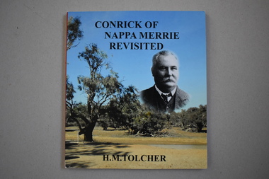
Book - Conrick of Nappa Merrie Revisited
This book is a 2015 transcription of a 1995 book by Helen Tolcher. It contains the story of the establishment in the 1870s of the Nappa Merrie station on the South Australian- Queensland border on the Coopers Creek. The station was established by John Conrick after he and three other men set off with 1600 cattle in 1872 from Koroit in Victoria, arriving at the new property site eleven months later. John Conrick (1852-1926) was the son of Patrick and Ellen Conrick who were farmers in the Tower Hill area. John Conrick had four sons who continued to run Nappa Merrie until family connections to the property ceased in 1960. This book is of interest as a record of the legend-making overland cattle droving feat by Koroit resident, John Conrick and three others in the early 1870s and of the establishment of an important property in Queensland following the overland trip. This is a soft cover book of 132 pages. The cover is multi-coloured with photographs of John Conrick and the Dig Tree site at Coopers Creek. The pages contain a preface, 19 chapters of text and an index. There are several maps and many black and white and colour photographs. conrick family of koroit, nappa merrie property, queensland, warrnambool -
 Warrnambool and District Historical Society Inc.
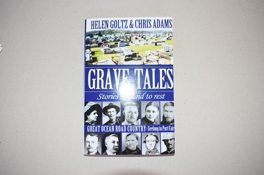
Book, Grave Tales, 2017
This book details the lives of some people of the past who are buried in cemeteries along the Great Ocean Road. Of particular interest to Warrnambool and district readers are the documented lives of Jack Denham of the La Bella shipwreck, early Warrnambool settlers, Agnes and James Ruttleton, William Sharrock, hero of the Nestor sinking, the Rutledge brothers and the Mills brothers of Port Fairy, the scientist Frank Burnet, the unionist William McLean, Dick the bushranger and Captain Pye, V.C. This book is of interest as it gives information on a variety of historical figures buried in cemeteries in the Great Ocean Road districts (Geelong to Port Fairy). It will be useful to researchers. This is a soft cover book of 290 pages. It has black and white and coloured photographs on the front and back covers and printing on the spine and back and front covers. The pages contain an introduction, 22 chapters, black and white photographs and maps and illustrations. western district of victoria, warrnambool -
 Warrnambool and District Historical Society Inc.
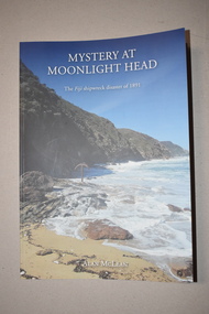
Book, Bart n Print Pty Ltd, Mystery at Moonlight Head, 2018
This book written by Alan McLean records the historical details concerning the wreck of the Fiji at Moonlight Head, Victoria in 1891. The ship was travelling from Hamburg and bound for Melbourne when it was wrecked at Moonlight Head. Twelve lives were lost and a subsequent enquiry found the captain to be guilty of negligence. Residents of Warrnambool and district had some connection to the wreck as Joseph Jordan, a Warrnambool photographer, took photographs of the wreck scene and was involved in a controversy regarding the late arrival of rescue equipment and residents from the Warrnambool area were charged with stealing some of the wrecked cargo.This book is of considerable local interest as the wreck of the Fiji was connected with Warrnambool and district and affected many local residents.This is a soft cover book of 176 pages. It has a cover with a blue background, some printed material and two colour photographs. The book contains an acknowledgement, an introduction, 21 chapters and appendices. It also contains black and white and colour illustrations, maps and other images. To Warrnambool and District Historical Society With Best Wishes Alan McLeanwreck of the fiji, history of warrnambool, alan mclean, warrnambool photographer -
 Warrnambool and District Historical Society Inc.
Book, Pam Marriott (publisher), Top Dog of the West, 2017
This book, written by Pam Marriott, is subtitled ‘A Study of the Belfast and Western District Civil Service 1841-1886’. It contains information on the police, police magistrates, court officials, customs and immigration officials etc who lived and worked in the Port Fairy and Warrnambool districts in the 19th century and many of the incidents and events with which they were connected. The book includes much information that is relevant to Warrnambool’s past. This book is an important acquisition to the Warrnambool & District Historical Society library as it contains information on many 19th century Warrnambool personalities, including policemen and court officials. It also has detailed information on some events that occurred in the Warrnambool district in the 19th century. This is a soft cover book of 480 pages. The cover and spine are white, with a black and white photograph and black printing. The pages include an introduction, eleven chapters of printed material, an index, a bibliography and appendices. There are several black and white photographs, plans, maps and other illustrative material. western district 19th century history, western district civil service 19th century, history of warrnambool -
 Warrnambool and District Historical Society Inc.
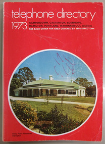
Book, Telephone Directory 1973, 1973
The numbers listed in this directory are under the heading of districts and the listings within the districts are again sub-listed under the various towns. So in the Warrnambool district there are listings under Winslow, Panmure, Orford, Port Fairy. Wangoom etc.This directory is of some importance as the names and addresses of those with telephones in 1973 in the local areas are listed. Most of the listings of the smaller towns give the names of the homes and properties. So this is a very useful tool for research purposes.This is a soft cover booklet with a red cover and an oval-shaped insert colour photograph of Stony Point Homestead, Darlington, on the front cover and a map of the telephone area on the back cover. Front cover – Telephone Directory 1973, Camperdown, Casterton, Edenhope, Hamilton, Portland, Warrnambool districts. See back cover for area covered by this directory Spine – Camperdown, Casterton, Edenhope, Hamilton, Portland, Warrnambool districts. See the pink pages for business & trade listings. VI- 1973 Back Cover – Country directory areas. The area covered by this Directory is the coloured portion of this map. See the pink pages for business and trade listings. warrnambool, warrnambool telephone directory 1973 -
 Warrnambool and District Historical Society Inc.
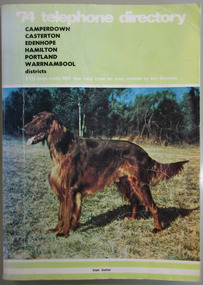
Book, Telephone Diretory 1974, 1974
The telephone directory contains both White Pages and Pink Pages listings. The White Pages listings are in alphabetical order of names for the entire 055 district. This directory is of some importance as it lists the names and addresses of people and businesses with telephones in 1974 in the 055 area code. Most of the listings of the smaller towns give the names of the homes and properties. So this is a very useful tool for research purposes.This is a soft cover booklet with a green cover and a colour photograph of an Irish Setter dog on the front cover and a map of the telephone area on the back cover. Front cover – ’74 Telephone Directory, Camperdown, Casterton, Edenhope, Hamilton, Portland, Warrnambool districts. STD area code 055. See back cover for area covered by this directory Spine – Camperdown, Casterton, Edenhope, Hamilton, Portland, Warrnambool districts. See the pink pages for business & trade listings. V1- 1974 Back Cover – Country directory areas. The area covered by this Directory is the coloured portion of this map. See the pink pages for business and trade listings. warrnambool 1974, warrnambool telephone directory 1974, 055 telephone directory -
 Warrnambool and District Historical Society Inc.
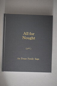
Book, White’s Law Bindery, All for Nought an Evans family saga, 2018
This is a family history of the Evans family.This is a hard cover book of 188 pages. The cover is grey with gold printing on the front and the spine. It has colour and black and white photographs, sketches, maps and illustrations. non-fictionThis is a family history of the Evans family.j.r.evans & family, warrnambool, warrnambool history, john russell evans -
 Warrnambool and District Historical Society Inc.
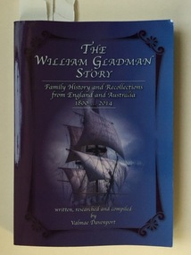
Book, Valmae Davenport, William Gladman Story, May 2016
This is a history of the family and descendants of William Gladman.This is a soft cover book of 374 pages. The cover is coloured mauve with an image of a sailing ship enclosed by an ornamental border on the front cover and an image of William Gladman on the back cover. The book has a Disclaimer page, an Acknowledgements page, Contents pages, a List of Illustrations, 21 Chapters and a Bibliography. There are many black and white photographs, maps and family trees. The inscription on the inside title page is handwritten in blue biro. non-fictionThis is a history of the family and descendants of William Gladman.william and rhoda gladman, gladman families, winchelsea, history of warrnambool -
 Warrnambool and District Historical Society Inc.
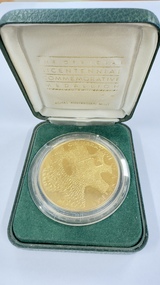
Medal - Bicentennial Commemorative Medallion, Royal Australian Mint, Canberra, 1988
This medallion was produced at the Royal Australia Mint in Canberra in 1988 to commemorate the Bicentenary of European settlement in Australia. The obverse design was by Michael Meszaros and the Bicentenary logo was designed by Michael Tracy. This medallion was given to Elizabeth Douglas in 1988 in recognition of her work as Secretary of the Shire of Hampden Bicentennial Community Committee. At the time Miss Douglas was Principal of Derrinallum High School, a position she held from 1984 to 1991. In retirement Elizabeth O'Callaghan (nee Douglas) spent many years as an active member of the Warrnambool and District Historical SocietyThis item is of historic interest as an example of a Bicentennial medal awarded to a local individualThis is a medallion of circular shape and bronze colouring (gold-plated). On the obverse side it has a raised gold pattern representing masses of people with a flag and gold lettering. On the reverse side it has a stylised map of Australia with gold lettering and sprays of flowers. The medal rests on a round plastic container inserted into a rectangular green box with felt trimming. The box is contained in another green cardboard box Australian Bicentenary 1788-1988 Celebration of a Nation Australia 1788-1988 The Official Bicentenary Commemorative Medallionaustralian bicentenary, bicentennial medallion, elizabeth douglas derrinallum -
 Warrnambool and District Historical Society Inc.
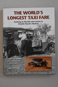
Book, Graffiti Publications, The Word's Longest Taxi Fare, 2014
This book documents a 1930 taxi fare from Lorne to Darwin via Warrnambool.This is a hard cover book with a black cover with silver-coloured printing on the front and spine. The dust cover has a white background with several black and white and colour photographs and white and brown printing. The book contains an introduction, 13 chapters of text and the publisher’s acknowledgements. The text includes many black and white and colour photographs, diagrams and maps. non-fictionThis book documents a 1930 taxi fare from Lorne to Darwin via Warrnambool.charles heard, car travel in 1930, history of warrnambool -
 Warrnambool and District Historical Society Inc.
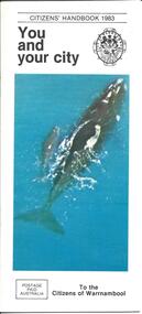
Booklet - City of Warrnambool Citizens' Handbook 1983
This Citizens' Handbook was posted to all citizens of Warrnambool in 1983. It contains an introductory message from the Mayor of the time, Cr. Ron Anderson and information relating to council run facilities and services. There is a page explaining the Warrnambool Bike plan and a section on how to save water. The blue centre pages explains property valuations and how to pay council rates. The rear page lists the contact details for councillors from each of the four municipal wards (Albert, Hopkins, Merri, Victoria) This booklet is an example of information provided to all City of Warrnambool citizen's in 1983. It gives an overview of council run facilities and services in 1983 and will be useful for researchers.A 20 page stapled booklet. Sixteen pages are printed on glossy white paper with black print. The centre pages are blue with black printing. The front cover has a black and white City of Warrnambool crest in the top right and a colour photograph of a Southern Right whale and calf swimming in the sea. The bottom left hand corner of the front cover has a postage paid rectangle printed in black print. The left hand side of the back cover has four ward maps printed in yellow and red. The ward names are printed in blue and the Councillor's details are in smaller brank print.Front Cover: Citizens' Handbook 1983 You and your city; Postage Paid Australia; To the Citizens of Warrnambool Back Cover: Your Ward Councillors Albert Hopkins Merri Victoriawarrnambool city council, citizens' handbook, warrnambool performing arts centre, warrnambool bike plan, albert ward, hopkins ward, merri ward, victoria ward -
 Flagstaff Hill Maritime Museum and Village
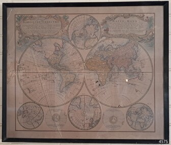
Map - World Map, Mappe Monde [Medieval Map of the World], 1910
This map from the mid-18th century doesn't include the finer details of land and sea masses that we know today. The map was produced by German cartographer and publisher, Johann Baptist Homann (1663-1724) and published in 1746, after his death. Earlier versions were published, such as 1707 and 1716. The date can be calculated from the Roman numerals on the top left text area. This print of a map is significant for its connection with early world explorers. A comparison of maps over the centuries shows the progression of navigational technology, the countries who claimed the land they explored. The naming of even some Australian locations shows who had already made their mark on Australia in the early 18th century. The print shows the fine details included by the cartographer and the beauty included that makes it attractive and interesting even today. The map is also significant for its connection with German cartographer, Johann Baptist Homann, whose Homann publishing company was renewed in Germany for producing high quality maps and atlases. Map behind glass in dark brown wooden frame on beige paper. The Coloured hand drawn line drawings show different hemispheres of the known world in the mid-18th century. Beautifully drawn figures and decorative embellishments enhance the map. The text on the top right has an explanation of the Figures I, II, III, and IV. This print of the 1746 map was produced in England by Leisure Arts Ltd. "PLANIGLOBIL TERRESTRIS" "MDCCXXXXVI" [1746] "MAPPE_MONDE" [Medieval Map of the World] "LEISURE ARTS LTD" "Printed in England"flagstaff hill, warrnambool, flagstaff hill maritime museum, flagstaff hill maritime village, flagstaff hill maritime museum and village, shipwreck coast, world map, french map, 18th century map, leisure arts ltd, cartography, early exploration, cartographer, johann homann (1663-1724), exploration, naviagtion, 1746 planiglobil terrestris -
 Warrnambool and District Historical Society Inc.
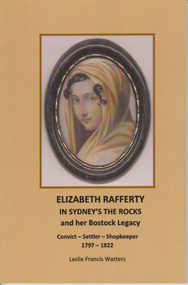
Book, Leslie Francis Watters, Elizabeth Rafferty in Sydney's The Rock's, and her Bostock Legacy, 2014
Family history of Elizabeth RaffertyThis is a small book of 64 pages with a buff-coloured plasticised cover with printed material and a photograph of Elizabeth Rafferty. The pages contain printed material, maps, photographs and illustrations and an index.non-fictionFamily history of Elizabeth Rafferty bostock family, elizabeth rafferty, warrnambool, rachel rafferty, robert bostock -
 Warrnambool and District Historical Society Inc.
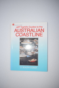
Booklet, Hodder & Stoughton (Australia) Pty Ltd, Australian Coast Line, 1987
This book details the places and towns along the south coast of Australia. It contains potted histories and information for tourists. Some of the information regarding places to stay and recreational facilities etc will date over the years and the book will be of less use.This book is of minor interest as a summary of the places along the coastline of Victoria and as a useful resource book in our library.This s a soft-cover book of 128 pages. It has a blue cover with a colour photograph and red and white printing on the front cover and a colour photograph of the author and black printing on the back cover. The pages contain printed material, black and white photographs and maps and sketches. coastline of victoria, history of warrnambool -
 Warrnambool and District Historical Society Inc.
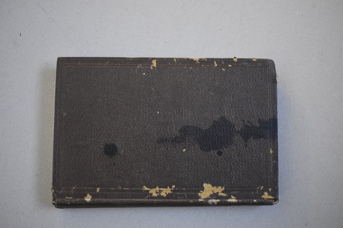
Book, Victorian Institute of Surveyors Transactions and Proceedings 1919, 1919
This book belonged to John William Crawley, Junior, a member of the Victorian Institute of Surveyors. He was an engineer, architect and surveyor in private practice in Warrnambool and also the engineer for the Shire of Warrnambool from 1895 to 1935. His father, brother and son were also engineers and worked in that capacity or as the Shire Secretary for the Shire of Warrnambool, with the Crawley family members recording a total of 132 years of service to the Shire of Warrnambool which existed from 1863 to 1994. This book is retained as it belonged to John Crawley, the engineer for the Shire of Warrnambool for 40 years. This is a hard cover book with a dark brown cover with gold lettering on the spine. The cover is stained and worn away in places. The book contains 14 articles, reports of the Council for the years 1909 to 1919 and office-bearers for 1919-20. There are several black and white photographs and fold-out maps and plans. The signature on the first page is handwritten in black ink.J Wm Crawley 9/9/19crawley family, warrnambool, shire of warrnambool, history of warrnambool -
 Warrnambool and District Historical Society Inc.
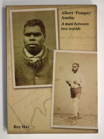
Book - Pompey Austin biography, Roy Hay, Albert 'Pompey' Austin - A Man Between Two Worlds, 2020
This book tells the biography of Pompey Austin an indigenousThis is a book of 266 pages. It It has a buff-coloured cover with 3 photographs and black printing. The pages contain printed text, maps, illustrations and photographs. non-fiction This book tells the biography of Pompey Austin an indigenous framlingham aboriginal mission, pompey austin -
 Flagstaff Hill Maritime Museum and Village
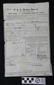
Document - Ticket, voyage, P & O Branch Service, P & O, Australia via The Cape Service, Bef.3rd June 1929
The bearer of this ticket was George Thomas Henry Phillpot, who was only 17 years old when he sailed on the S.S. Ballarat (II), built in 1921. (The first S.S. Ballarat was built in 1911 and sunk after being hit by a torpedo in 1917 while serving during WWI). George relates his trip from England to Australia, summarised as follows: He caught a bus from Bolton to Manchester, in the north west U.K., then the train from Manchester to London and the boat train to Tilbury Docks (near Gravesend). On the morning of June 7th 1929, the ship S.S. Ballarat sailed down the Thames estuary and into the English Channel. The next port of call was Southampton, UK, to take on board some technical equipment. The S.S. Ballarat then sailed through the Bay of Biscay. Instead of taking the customary route around the Cape of Good Hope, this trip, on her maiden voyage, was through the Suez Canal. She sailed through the Straits of Gibraltar, into the Mediterranean Sea and on to Malta, where George and others paid a local boat owner to take them ashore for a short time. They then sailed to Port Said, stopping to load cargo, then at night through the Suez Canal. They woke up early the next morning to watch the locals working on the banks of the canal. The excessive heat on board the ship caused much illness. As they travelled through the Red Sea, the heat and the smell of oil also caused sickness. On they went through the Arabian Sea to Colombo, the capital of Sri Lanka (which at that time was called Ceylon). A Navigation Slip, donated together with this ticket, shows the coordinates for a location 16 miles from Colombo. They again went ashore for a meal at four-pence a head and a bottle of lemonade for a penny. George and another passenger walked to the slums area and were shocked at the state of it compared to Britain’s slums. They then sailed via the Indian Ocean to Fremantle, stopping again for goods to be unloaded. While ashore, they played a game of soccer against the ship’s crew. Then on to Port Adelaide via the Great Australian Bight. Here they shopped for suitable clothing under the advice of some Australian passengers. They then arrived at Port of Melbourne on July 20th 1929, and two days later (on George’s mother’s birthday). George left for Warrnambool. He received his Citizenship Award in 1971. He conducted an electrical retail business in Liebig Street for many years. His son William became principal of the accounting business Sinclair and Wilson, on the retirement of Bill Sinclair, and was actively involved in support of many community organisations. His daughter-in-law, Glenys Phillpot, is actively involved in the Warrnambool community and local government. George was one of 3 orphans on the S.S. Ballarat. (The daughter and son-in-law of one of the other orphans also live in Warrnambool.) Herbert B.G. Larkin, whose rubber-stamped name appears on the ticket, later migrated to Australia and passed away in NSW in 1944. Of Historical Significance, this ticket is for the ship’s maiden voyage via the Suez Canal route (previously the ship travelled via the Cape of Good Hope). It is also the only existing ticket for the "S.S. Ballarat"(3rd) in our collection. Socially, it shows the fare, luggage restrictions, conditions and weekly provisions for a third-class passenger’s voyage from London to Melbourne, which has research potential. This ticket is also of significance to the Local Community, giving the background of the ancestor of a local family. It was also of Personal Significance to the bearer as he kept and preserved it in his possession for at least 46 years before donating it to our museum, together with a Navigation Slip, a map and a summary of his journey to Australia.Third Class steerage Passenger’s Contract Ticket, accompanied by the Navigation Slip, for passage on board the P & O line’s steamer, S.S. Ballarat, to Australia via the Cape Service, from Port of London to Port of Melbourne. The ticket contract is printed on both sides of a thin paper page. The documents have been completed by hand, and the pages have creases as though they have been folded. Details include the date of sailing, amount paid, and the signature of the P & O Branch Service’s representative. The contract ticket lists weekly provisions for the voyage, a disclaimer of the shipping company, a list of dangerous goods not to be carried on board, and fines. The page has straight edges, top and bottom, and perforated edges on the sides; some perforation holes are complete. A small fleur de lies is printed along the inside of each perforation, forming a decorative left and right border. Stamps and inscriptions are on the contract ticket and navigation slip, which also has a black and white photo of a steam ship.The ticket has been stamped in black, No. ‘1040’. Handwritten details are in black pen and ink. Date of departure: ‘Seventh June [192]9’ for the cost of,’33’ [poind], and the sum of ‘33’ pounds is acknowledged as received. ‘Mr George T.H. PHILLPOT’, the age is written as ‘17’, equal to the status of ‘1’ adult, the total number of persons is ‘One’. The fare is handwritten in pen £’33’ and the total £’33’. It has a purple stamp ‘HERBT. B G LARKIN’ and a crossed out stamp ‘FREDERICK WHITE, A handwritten signature ‘_Seymore’. Under the signature, the date is stamped ‘3 JUNE 1929’.warrnambool, shipwrecked coast, flagstaff hill, flagstaff hill maritime museum, maritime museum, shipwreck coast, flagstaff hill maritime village, s.s.ballarat, phillpot, 7 june 1929, george phillpot, george t.h. phillpot, third class passenger, steerage passenger, herbert b g larkin, ticket, voyage, p & o, australia via the cape, cape of good hope, suez canal, passengers’ contract ticket, navigation slip, s.s. ballarat, steamship, 1929, 3-6-1929, 7-6-1929, third-class, steerage, port of london, port of melboune, 33 pounds, george thomas henry phillpot, herbt. b g larkin, _seymore, bolton, manchester, english channel, southampton, bay of biscay, straits of gibraltar, maritia, port said, arabian sea, colombo, sri lanka, ceylon, indian ocean, fremantle, port adelaide, citizenship, 1971, herbert b.g. larkin, s.s. ballarat ii,