Showing 3903 items matching "bricker"
-
 Kew Historical Society Inc
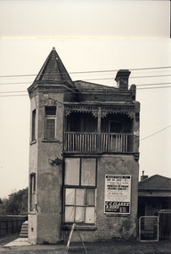
Photograph - 'Mouse' House, 104 Peel Street, Kew, 1980
The two-storey house at 104 Peel Street, known locally as The Mousehouse, was built in 1890 of stucco-rendered handmade bricks. The ground floor façade suggests that the front door originally opened directly onto the street. Prior to 1915, the house was numbered 184, but the street number changed to 104 in that year. Early residents included Henry Martin, Mrs Henrietta Blythe and A. R. Chaffer, the two latter being shopkeepers. The eminent dentist Samuel E. Wills, who had rooms in Collins Street, moved to the house in 1897 and lived there for six years. He was reputed to have conducted a dental practice in the cellar. Wills proposed the establishment of a Dental College in Melbourne and helped to frame Victoria’s dental rules and by-laws. Enlarged photograph mounted on board, donated to the Kew Historical Society by the City of Kew on 10 April 1991. houses - kew (vic), peel street - kew (vic) -
 Kew Historical Society Inc
Photograph - Cluny Convent (formerly 'Fairview'), 34 Wrixon Street, 1988
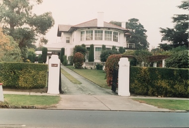
Frederick J. Robinson, a manufacturer, was the owner and occupier of a nine-roomed brick house by at least 1934. At that date the N.A.V. for the property was £270 while in the following year the N.A.V. increased to £350 with a note of 'additions' being made, recorded in the Rate Books. By December 1936 Robinson's house was being described as having twelve rooms and an N.A.V. of £295. The works were undertaken for Robinson by the leadng architect, Harold Desbrowe Annear, and appear to have been a comprehensive remodelling of the Victorian house on the site, the outline of which was clearly depicted in the MMBW plan of 1903. 'Fairview' is of significance as a comprehensive remodelling of a Vietorian house undertaken in the 1930s by the leading architect of the time, Harold Desbrowe Annear. The 1930s are integral to the significance of the whole. (Kew Conservation Study, 1988)Colour photographic positive of Cluny Convent (formerly 'Fairview') remodelled by the architect Harold Desbrowe Annear in the mid 1930s. cluny convent -- kew (vic.), fairview -- 34 wrixon street -- kew (vic.), harold desbrowe annear -
 Kew Historical Society Inc
Photograph - Cluny Convent (formerly 'Fairview'), 34 Wrixon Street, 1988
Frederick J. Robinson, a manufacturer, was the owner and occupier of a nine-roomed brick house by at least 1934. At that date the N.A.V. for the property was £270 while in the following year the N.A.V. increased to £350 with a note of 'additions' being made, recorded in the Rate Books. By December 1936 Robinson's house was being described as having twelve rooms and an N.A.V. of £295. The works were undertaken for Robinson by the leadng architect, Harold Desbrowe Annear, and appear to have been a comprehensive remodelling of the Victorian house on the site, the outline of which was clearly depicted in the MMBW plan of 1903. 'Fairview' is of significance as a comprehensive remodelling of a Vietorian house undertaken in the 1930s by the leading architect of the time, Harold Desbrowe Annear. The 1930s are integral to the significance of the whole. (Kew Conservation Study, 1988)Colour photographic positive of Cluny Convent (formerly 'Fairview') remodelled by the architect Harold Desbrowe Annear in the mid 1930s. cluny convent -- kew (vic.), fairview -- 34 wrixon street -- kew (vic.), harold desbrowe annear -
 Vision Australia
Administrative record - Text, Seventeenth Annual Report of the Association for the Advancement of the Blind 1912, 1912
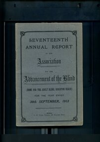
Annual report of the Association for the Advancement of the Blind outlined activities and events over the year, including membership of 333, with the support of Mrs W.H. Edgar and the Lady Mayoress of Melbourne, 'Woodburn' was purchased and there were sufficient funds to reconstruct a wing to the present brick building, and plans are being drawn up under the supervision of Mr Paterson for some necessary extensions, the North Melbourne and Essendon Electric Tramway and Northcote Cable Tramway were added to the Railway Pass concession scheme, a successful concert tour was made of the Goulburn Valley from Alexandra down to the Murray, the loss of Mr Bacon - who was the first Blind Collector appointed by the Association - and Mrs May Harrison, VABW secretary who tirelessly promoted the welfare of the blind.1 volume of printed material with some illustrationsassociation for the advancement of the blind, annual reports -
 Eltham District Historical Society Inc
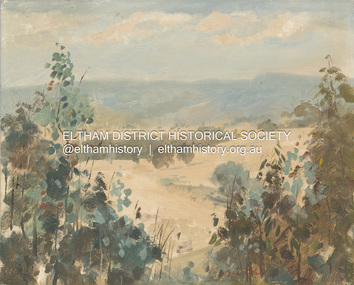
Artwork, other - Painting, Peter Glass, Summer Landscape, Kangaroo Ground, 1968
Arthur William Glass known as Peter was born August 28, 1917. During the 1930s, Peter Glass and a young Graeme Bell were studying painting under Max Meldrum. Graeme Bell at that time was undecided whether to devote his life to music or painting. In 1938, inspired by what they had seen at 'Montsalvat', Peter Glass along with Graeme and Roger Bell (whose names were to become internationally known as the leaders of Australia's most famous jazz band) agreed to purchase land at Eltham to build themselves a mud brick house. For some time, Eltham had been their chosen place for painting and sketching, but it was not until they visited the 'Jorgensen Colony', as it was then known, and saw the possibilities of building in earth, that they decided to establish a permanent base in Eltham. In July, the three of them bought a few acres of land at the top of John Street and started making mud bricks for a proposed sixty square sized house. Following the Second World War, Peter Glass returned in 1946 to live permanently in Eltham. He resumed work on building of the adobe house which he had commenced before the war. During some years spent in England and France he married a French girl and on returning to Eltham he built another adobe house in which he lived with his wife, Cecile Madeleine, and two children, Julian and Marie-Luce on land adjoining the original house. Peter Glass died in December 1997 aged 80, his wife Cecile in 2006, aged 79. They are memorialised in Eltham Cemetery. Much of the inspiration for his landscape painting comes from the Eltham bush and the Yarra flowing through it.oil on chipboard 33 x 40.5 x 1.0 cm Signed 'Peter Glass in red paint lower right of centre Evidence of some paint rub-off at edges from previous frame mounting (frame removed).Reverse side painted in pale yellow cream and inscribed: 'Summer Landscape - 1968 Kangaroo Ground' in black paint1968, arthur william glass, artwork, kangaroo ground, paintings, peter glass -
 City of Moorabbin Historical Society (Operating the Box Cottage Museum)
Plaque, Official Opening Reconstruction Box Cottage 1984, 1984
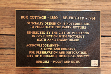
The original small, pioneer cottage was built in the late 1840s to early1850s, by an unknown pioneer. It was located on part of a 30 Acre allotment that was originally part of Dendy’s Special Survey granted in 1841. The doors and window sashes, (made of red deal joinery timber), as well as the brass locks and fittings, are from the original cottage, and were imported from England. The fire-place bricks are from the original cottage, and are sun-dried, (not kiln fired), and are hand-made. Convict marks can be seen on two bricks. There is a small display of external cladding shingles from the original pioneer cottage. These shingles were hand-split, and most likely made from locally collected timber The nails included in this display were used to fasten the shingles on the original cottage, and are also hand-made. The enamel nameplate, “Colonial”, on the wall of the cottage, was the name chosen for the original pioneer cottage when Mr August Reitman, a sculptor, began leasing the property in 1917. August purchased the property c 1935, for 1200 Pounds approximately and resided there until 1953. He sold it to Lewis Timber Co Pty Ltd in 1970. In 1974 Mr Lewis, a timber specialist, found the dilapidated building on the property he had recently purchased in Jasper Rd and suggested it be reconstructed and relocated. Moorabbin City Council agreed and the cottage was rebuilt about 250 metres from its original site. The cost of the rebuild was met by 'Victoria's 150th Committee, plus a small grant from the City of Moorabbin, and Mr Laurie Lewis donated much of the timber for the reconstruction. CMHS volunteer members operate the Box Cottage Museum which is open to the public on the last Sunday of the month or by appointment. the Official Opening of the Reconstructed Box Cottage on November 18th 1984A plaque commemorating the Official Opening of the Reconstructed Box Cottage on November 18th 1984BOX COTTAGE - 1850 - RE-ERECTED - 1984box william, box elizabeth avis, deny's special survey 1841, brighton, moorabbin, ormond bentleigh, mckinnon, market gardeners, pioneers, early settlers, reitman august, reitman william, lewis timber co pty ltd, moorabbin city council 1934 – 1994, -
 Surrey Hills Historical Society Collection
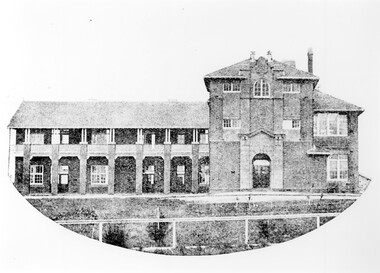
Photograph - Mont Albert Primary School, 1926
This was reproduced from a copy of the 1926 flyer relating to the Annual Speech Night. See vertical file re Mont Albert Primary / Mont Albert Central School. It was reproduced with the consent of the school archives in the early 1980's by Kenneth Tudor Hall. Mont Albert Primary was built in 1917 and was designated as a Central School in 1918 when Forms 1 & 2 were added. It remained as such until the 1964 when the secondary years formed the basis of a new high school, known as the Box Hill North High School, (later changed to Koonung Secondary College). The original building was constructed of solid red brick and consisted of seven rooms. In May 1924 a further four rooms, also in red brick, were added. The school opened with an initial enrolment of 147 students in Prep to Grade 6. A further 72 children were admitted during the year, making a total enrolment in the first year of 219. The land facing Kenmare Street was purchased in 1919, adding another 2 acres to the 5.5 acres which the school occupied in 1917. The first Principal was Charles Hyland, who was assisted by three teachers. The first official meeting of the School Council in May 1917 reveals that the building was in some senses a shell, requiring additional input from parents. Mention is made of the need for asphalting of playing areas, providing a letter box and electric lights for the lobby, double room, office and sewing room. Mont Albert was the first School in Victoria to have the interior purely constructed of Victoria hardwood, from floor to ceiling. An Honour Board was erected in 1919. mont albert central school, mont albert primary school, mont albert, schools -
 Kiewa Valley Historical Society
Photos - Mt Beauty Buildings in 1973. Set of 8, 1973
The shopping centre in Mt Beauty, both buildings and streetscape, have undergone significant changes since 1973. The kindergarten has undergone extensive remodelling, The Chalet has been replaced by Svarmisk Resort and Accommodation Spa. Tawonga hospital has undergone extensive renovation and is now Mt Beauty Hospital AND Kiewa Valley House. The Workman’s Club changed name to the Country Club and has since closed down. Hospital and Kiewa Valley House now occupy what is shown as a vacant lot opposite the motel which is now called Mt Beauty Motor Inn.The houses in Mt Beauty were brought in by the State Electricity Commission of Victoria when they constructed Mt Beauty Town for their workers building the Kiewa Hydro Electric Scheme. Mt Beauty is unique began as a construction town in the late 1940's.Colour photographs of various buildings in Mt Beauty taken in 1973 1. Workman’s Club 2. View over the pondage 3. Tawonga Hospital (Mt Beauty) 4. Mt Beauty Chalet 5. Mt Beauty Kindergarten 6. The Merjei Motel 7. 8 Valley Avenue 8. Shopping Centre Handwritten in ink on the back of photos 1. Workman’s Club 1973 (after the brick makeover) From the sports oval – the high school is to the right 2. A view over the pond 1973 3. Tawonga Hospital 1973 (Mt Beauty) 4. Mount Beauty Chalet 1973 5. Kindergarten 1973 6. The Merjei Motel 1973 7. Our house at 8 Valley Ave 1973, Owner after us erected the car port, let the front hedge run amok and vanquished the vegetable garden and citrus trees Dad created. 8. Shopping Centre 1973. At the end of the street is the hospital (believe it is now Mt Beauty Bush Nursing Hotel) mt beauty, workman's club, chalet, tawonga hospital -
 Kiewa Valley Historical Society
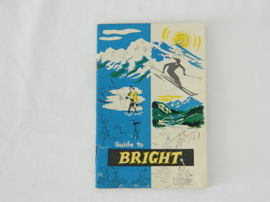
Pamphlet - Bright Tourism, Guide to Bright and District, late 1900s
This publication was produced in the early 1950s to provide the growing tourism trade (at this time), to the region with a more detailed overview of the facilities available to tourists of the region's attractions. This brochure is a very efficient and effective promotional publication. The increasing level of self promotion by local business and commerce sectors of the region the more sought after the region became and the greater the ability of the region to grow (non rural based economy). Some of the regions unique facilities and geological structures are well suited to those tourists who live in cities and "flat land" regional bush areas within Australia. This was a period when the average Australian domestic tourist was more able (finance and transport wise) to see more of their country within the short time they had for "holidays". In the late 1900s, however, with the increase to workers' recreational leave and better transportation (fares, ease of travel to overseas destinations) the local tourism numbers from other domestic locations have been steadily declining. From the 1970s onwards, the increased tourism demand from overseas tourists, for better facilities and easier access to these regional facilities, resulted in better transport, accommodation and communication, which has been a boon for all tourism within Australia. In the 21st century the world is becoming smaller and smaller for the international tourist, especially for those from crowded Asian cities. The greater attraction for "open" spaced locations such as this region are becoming a much sought after change of scenery. This pamphlet which targets the tourist, whether either from other Australian regions or the global tourist, is a good example of self promotion by a relatively small local population. This is especially significant because before the "tourist explosion" in the 1950s onward, these regional areas had a more introspective society with greater emphasis to locally established mores and values. The increased interactions with people from other areas and nations, combined with a greater global communication network is affecting those traditionally established mores to produce a some what unique social transformation which is constantly changing from one generation to the next. One important factor which tourism does bring is that it opens up the region to a wider range of people who look to the region for their own lifestyle changes.This pamphlet has a front cover in colour with the major activities in the region sketched depicting : sunshine, snow skiing, trout fishing, mountain climbing, golfing, swimming, alpine views, tennis, lawn bowls and picnics. The back cover is blank. The pamphlet is fastened together by two staples 30mm from top and bottom, and is folded with the cover slightly thicker than the fifteen pages. Thirteen pages have been printed on both sides. The first page has a black and white photograph of the hotel Alpine and the tall brick constructed Clock Tower. There are another five black and white photographs in the pamphlet.on front cover "Guide to BRIGHT"local tourism, regional information booklet, "time" related brochures, alpine local history -
 Federation University Historical Collection
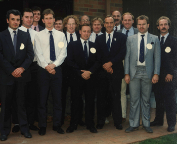
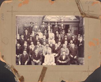
Photograph - Photograph - Colour, Group Portrait of Brewing Students with Premier John Cain, 1990, 1990
The photo was taken in 1990 at the official opening of Pacific Maltings in Gregory Street West, Ballarat by Premier of Victoria the Hon. John Cain. Group portraits of 14 men on a footpath next to a brick building. Most of the group are brewing students at Ballarat University College. I. Kerr (Brewing Student) R. Vickers (Brewing Student) G. Vincent (Brewing Student) S. Page (Brewing Student) G. Hughes (Brewing Student) S.T. Williams (Brewing Student) T. Gaffney (Brewing Student) Neville Gower (Lecturer in Brewing ) G. Fox (Brewing Student) Premier John Cain I. Richardson (Lecturer in Brewing) L. Cormie (Brewing Student) P. Vawdrey (Brewing Student) J. Armstrong (Brewing Student)i kerr, r. vickers, g. vincent, s. page, g. hughes, s.t. williamst. gaffney, neville gower, g. fox, premier john cain, i. richardson, l. cormie, p. vawdrey, j. armstrong, pacific maltings, s.t. williams, t. gaffney -
 Bendigo Historical Society Inc.
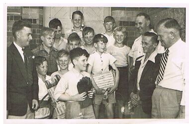
Photograph - PRESENTATION OF CRICKET EQUIPMENT TO PRIMARY SCHOOL BY SANDHURST CRICKET CLUB
group photo of 11 school boys with four men, standing outside brick building, wooden door behind group. Boys in front are holding cricket pads and gloves. Written on back : 'back: Neil Button, John Turner, Maurice Grose, Centre: Lance Orchard, Graeme Moore, Merv Miles, Les Rodda, F. Stave Wallace, Ken Hartley, Paul Gill, Trevor Phillips, Bill McConnell, Noel Turner Walshy !. Presentation of cricket equipment to school by Sandhurst Cricket Club, 1951 ? On bottom LH side : V. Phillips, 274 (?9) Eaglehawk Rd. Eaglehawk.bendigo, sporting clubs, sandhurst cricket club, cricket, sandhurst, school, presentation -
 Bendigo Historical Society Inc.
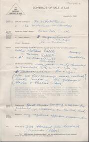
Document - H. A. & S. R. WILKINSON COLLECTION: CONTRACT OF SALE
Contract of sale of land dated 24th February, 1956 between Mrs. D. I. Smith (vendor) and Mr. A. W. & Mrs. N. Pulfer (purchaser). Solicitor for vendor: E. C. Cohen. Solicitor for purchaser: Hyett, Willis & Hyett. Property: land being lot 13on plan of subdivision No. 21180 lodged in the office of titles, being part of Crown allotment 457 section H Parish of Sandhurst described in certificate of title volume7793 folio 150 and situate No. 3 Margaret Crescent, Bendigo, together with brick veneer dwelling and all sundry. Price: 5,500 pounds.organization, business, h.a. & s.r wilkinson real estate -
 Bendigo Historical Society Inc.
Photograph - BENDIGO STOCK EXCHANGE MEMBERS
Black and white photograph on grey board. Forty six males arranged in front of double doorway with large fan light above. Cast iron gates/fences. CGI tank at L, brick building. Inscriptions: 'GP13' to L and RF corners. On back, hand written in ball point pen 'Bendigo Historical Society', 'Members of Bendigo Stock Exchange taken at rear of Exchange - near Allen's' Walk'. On back - circular rubber stamp 'Royal Historical Society of Victoria, Bendigo Branch'. History: James Lerk 19.11.1999 'Bendigo Stock Exchange members at the rear of the Exchange'.person, group, male group of workers -
 Bendigo Historical Society Inc.
Photograph - LARGE EDWARDIAN STYLE HOUSE ON CORNER BLOCK
Black and white photograph on embossed card. Large Edwardian? Style house on corner block. Gable roof with attic in front. Bay windows under return verandah with concrete rendered supports, decorative brick work on balustrade. Picket fence with lattice on top. Pergolas over gates. Inscriptions on front - 'Vincent Kelly, Bendigo'. On back - 'Knights/front view', TC Watts & Son, Auctioneer, Estate Agents, Imperial Fire Office. Beehive Chambers, Pall Mall, Bendigo' (rectangular decorative stamp on back). 'Royal Historical Society of Victoria, Bendigo Branch (circular stamp).buildings, residential -
 Bendigo Historical Society Inc.
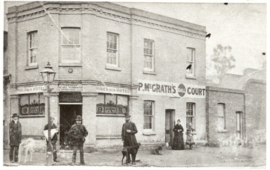
Photograph - HIBERNIA HOTEL: BENDIGO, 1910's
Black and white photograph, 'Hibernia Hotel' printed over windows. Left and right of corner entrance 'Bar' also in script, circular plaque above door. 'Licensed to sell' 'fermented' and 'spiritous' liquor, P. McGrath painted over entrance. P. McGraths ball court to side. 4 male figures in foreground of two storey brick building, gas lamp obscuring one figure. 1 black and 1 white dog. 1 adult female in dark long frock with adolescent female, lighter toned mid calf length frock with cape. 264 Bridge St., Bendigo.cottage, miners, d. walker 5.11.1999 : suggested hibernian hotel, cnr. bridge and cemetry st, had bowling alley' -
 Bendigo Historical Society Inc.
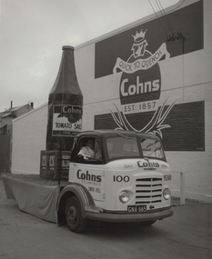
Photograph - COHN BROS TRAY TRUCK, c1957
Black and white photograph in cream folder with card frame inside. Tray truck with display on back, consisting of large model tomato sauce bottle on box. Brick building in background painted with advertising sign. Inscriptions: in image on wall 'Quick to Quench, Cohn's, est. 1857'. On truck 'Say Cohns Please:, '100 years', 'Cohn Limited, Sw3an Hill', 'Cohn's Tomato Sauce', Truck number plate 'GNA 665'. Hand written BR corner 'Reg V Brock'. Rubber stamp front BR corner, 'Reg V Brock of Bendigo'. History: Prev. Acc. No. MP201topic, transport -
 Bendigo Historical Society Inc.
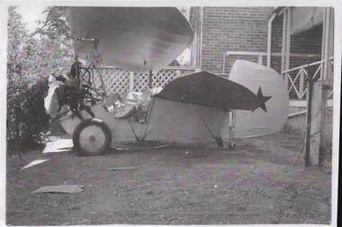
Photograph - QC BINKS COLLECTION: SMALL AEROPLANE
Copy of photo: image shows small aeroplane, in front of brick residence. Written on sheet: 'a small aeroplane of 'rare design' built up in the loft above the stables barn at the rear of the old Girton College, now part of the new Girton assembly hall. The builder was a Mr. Alan Manare - a boarder at 'Craigmore' As far as I can remember the aircraft made only a few short flights. I never heard of its eventual fate. The photo of the plane is taken on the High St. side of 'Craigmore' outside the builder's room.' Photo C. 1941. Copied from Q.C. Binks, photo.bendigo, girton, craigmore, binks -
 Bendigo Historical Society Inc.
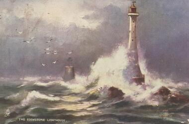
Postcard - GLADYS DEAN COLLECTION: POSTCARD, 1906 - 1908
Printed coloured postcard. Image is of The Eddystone Lighthouse and depicts a lighthouse on rocks with a smaller brick structure nearby in stormy seas and gulls in the sky. The words The Eddystone Lighthouse with a small symbol in white appear along the bottom left hand edge. Reverse is addressed to Miss Dean 'Esmond' Golden Square Bendigo and has a one penny stamp affixed postmarked Kerang. The words Raphael Tuck and Sons "Oilette" (Regd) postcard 7062 "Rough Seas" Art Publishers to Their Majesties the King and Queen after the black and white originals by Elmer Keene are printed in red along the left hand edge.Raphael Tuck and Sons 'Oilette' Regd Postcard 7062 'Rough Seas'postcard -
 Bendigo Historical Society Inc.
Photograph - LONG GULLY HISTORY GROUP COLLECTION: DON MINE & LONG GULLY STATE SCHOOL
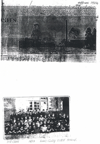
Copy of a black and white photo of the Don Mine, approx 1934. Written above the photo is - This mine is similar to the New Carshalton Mine off Sparrowhawk Road, Long Gully. Dorrie Crossley's Father Ben Williams was the manager. this is the Don Mine off Top end Sparrowhawk Road, Long Gully. Date above the photo January 7, 1997. Photo (not a very clear one) shows the poppet legs, chimney and some buildings. Below is a photo of the 1 & 2 Class children from the Long Gully State SChool 1933. The children are sitting or standing in front of a brick building.bendigo, history, long gully history group, the long gully history group - don mine, new carshalton mine, dorrie crossley, ben williams, long gully state school photo 1933 -
 Bendigo Historical Society Inc.
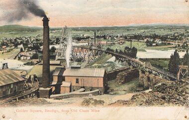
Postcard - GOLDEN SQUARE, BENDIGO FROM ' OLD CHUM' MINE
Postcard: hand coloured image showing mine site in Golden Square. Brick chimney in foreground, sheds. Tramway from LH side to poppet head behind chimney. On back of card ' Post GWW Card' Printed partly in Great Britain and partly in Germany. In black ink ' Dear Muncie Bob, I hope you arrived all right. I suppose you have started work before this. I don't start till 10th. Feb.' A stamp has been drawn, showing a house and written ' little house on the hill' Dated 1913.G.W.W.bendigo, mining, old chum mine, golden square, old chum mine, golden square, postcard -
 Kew Historical Society Inc
Print - Walmer Street Foot Bridge
A bridge to Walmer Street, Kew, from Abbotsford was located at the northern end of Burnley Street. It was a foot bridge.Photographic print of the Walmer Street Bridge. The view of the Bridge is from the Abbotsford side of the Yarra. A section of pipe on the near side of the bridge is a remnant of the irrigation pipes that carried water from above Dight's falls to the Melbourne Botanic Gardens. The former bridge, constructed in 1896 was swept away in the 1901 Flood. It has two major brick piers while the remainder of the trestle supports are metal. The original photograph from which this copy was made was taken after 1901 as it shows the second bridge under construction. Houses in Young Street, Kew, can be seen on the far side of the river.Written on reverse: "Walmer St. Bridge. Erected 1896. Being rebuilt after 1901 flood damaged it. Houses on left are in Young St."bridges -- kew (vic.), walmer street bridge, melbourne botanic gardens -
 Kew Historical Society Inc
Print - Walmer Street Foot Bridge, 1901
Photographic print of the Walmer Street Bridge. The view of the Bridge is from the Abbotsford side of the Yarra. A section of pipe on the near side of the bridge is a remnant of the irrigation pipes that carried water from above Dight's falls to the Melbourne Botanic Gardens. The former bridge, constructed in 1896 was swept away in the 1901 Flood. It has two major brick piers while the remainder of the trestle supports are metal. The original photograph from which this copy was made was taken after 1901 as it shows the second bridge under construction. Houses in Young Street, Kew, can be seen on the far side of the river.Reverse: " Walmer St footbridge 1901 being repaired after flood / Constructed 1892 substantially renewed in 1901 and in 1928 / Rebuilt in 1977 by Kew Council aided by State funding. Won for designer Martin Aylard a New Zealand award presented by the timber Research & Development Assoc / Site of Simpsons Road passenger foot ferry". bridges - yarra river -- kew (vic.), walmer street bridge -- kew (vic.) -
 Kew Historical Society Inc
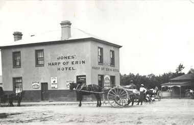
Photograph, Harp of Erin Hotel, c.1880
This work forms part of the collection assembled by the historian Dorothy Rogers, that was donated to the Kew Historical Society by her son John Rogers in 2015. The manuscripts, photographs, maps, and documents were sourced by her from both family and local collections or produced as references for her print publications. Many were directly used by Rogers in writing ‘Lovely Old Homes of Kew’ (1961) and 'A History of Kew' (1973), or the numerous articles on local history that she produced for suburban newspapers. Most of the photographs in the collection include detailed annotations in her hand. The Rogers Collection provides a comprehensive insight into the working habits of a historian in the 1960s and 1970s. Together it forms the largest privately-donated collection within the archives of the Kew Historical Society.Harp of Erin (c.1864-1956). Strategically situated on Bulleen Road (High Street) in East Kew, the ‘Harp of Erin’ was built on the corner of Harp Road and High Street. The present hotel is the third to be built on the site. A second, two storey brick and stucco hotel built c.1864 replaced an earlier wooden structure built in 1854 by Edward Glynn. The ‘Harp’ was a local landmark, used by the Melbourne Hunt Club for their meetings. The Club had their kennels behind the hotel, and at meets, red-coated riders might be seen assembling from all directions. The later building was constructed in 1956."Harp of Erin Hotel. Has been altered several times. First built by Edw. Glynn 1851. Not the first which was built in 1854."harp of erin hotel, dorothy rogers -
 Kew Historical Society Inc
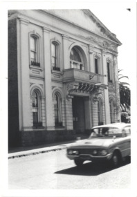
Photograph - Former Kew Town Hall, Walpole Street, 1970
The Municipality of Kew was granted independence in 1860. It was declared a borough in 1863, a town in 1910 and a city in 1921. In 1994, Kew was amalgamated into the new City of Boroondara.Black and white photographic positive of the front of the (former) Kew Town Hall in Walpole Street between High Street and Malmsbury Street, on the west side where Woolworth's supermarket now stands. The photograph, from August 1970 shows the detailing of the Italianate rendered-brick facade, added in the 1880s when the hall was renovated. The earliest building on the site was the Kew Athenaeum Hall (built 1860) which was purchased by Kew Council in 1865. The Town Hall was sold to Woolworth's and subsequently demolished in 1972 when the civic offices were transferred to a new building on the corner of Charles Street and Cotham Road."Old Kew Town Hall / Walpole St / Aug 1970/ Gift of Stewart West 1990"kew town hall -- walpole street, local government -- kew, civic buildings -- kew (vic.), town halls -- melbourne (vic.) -
 Kew Historical Society Inc
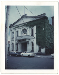
Photograph - Former Kew Town Hall, Walpole Street, 1972
The Municipality of Kew was granted independence in 1860. It was declared a borough in 1863, a town in 1910 and a city in 1921. In 1994, Kew was amalgamated into the new City of Boroondara. In 1960, a new Town Hall in Cotham Road was opened. The Municipal Offices that had remained in the former Town Hall in Walpole Street until it was moved to the new Civic Centre on the corner of Cotham Road and Charles Street in 1972.This is a rare and important colour photograph of the Kew Municipal Offices (former Town Hall) taken on 11/2/1972 in the year that the building was demolished and replaced by a Safeway Supermarket.Colour photographic positive (polaroid) of the front of the (former) Kew Town Hall in Walpole Street between High Street and Malmsbury Street, on the west side where Woolworth's supermarket now stands. The photograph, taken in February 1972, shows the detailing of the Italianate rendered-brick facade, added in the 1880s when the hall was renovated. The earliest building on the site was the Kew Athenaeum Hall (built 1860) which was purchased by Kew Council in 1865. The Town Hall was sold to Woolworth's and subsequently demolished in 1972 when the civic offices were transferred to a new building on the corner of Charles Street and Cotham Road.kew town hall -- walpole street, local government -- kew, town halls -- melbourne (vic.) -
 Surrey Hills Historical Society Collection
Photograph, Mair family visiting the Jarmans at Derrinallum, c1927 (2), c1927
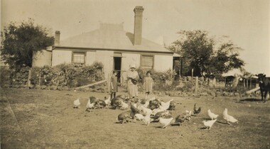
David Miller (Dave) Mair (1879-1938) married Lily Vipond Deakin (1890-1945) in 1910. They had 5 children: Geoffrey David (1913-1970), Beryl (1916-1976), Gwynneth (1917-1997), Isabel Lillian (1921-1997) and Shirley Inez (1928-1968). Personal communication from Laurie Newton, Beryl's daughter: Dave and Beryl initially lived in East Melbourne after they married. Dave walked across the gardens to work at the MCG. He never drove or owned a car. Geoffrey, Beryl and Gwynneth were born in East Melbourne. They subsequently moved to Louise Avenue, Mont Albert and Isabel may have been born while they were there. Later they purchased 20 Barton Street, Mont Albert. Shirley was born after they moved to Barton Street. Electoral roll details: 1919 1922 24 Louise Avenue, Mont Albert 1924 20 Barton Street, Mont Albert Dave Mair was a very keen sportsman. This is part of a large donation of material from the Deakin, Mair and Young families. The Deakin, Mair and Young families had many connections with Mont Albert and Surrey Hills.A sepia photo of a woman and 2 girls standing behind about 30 fowls. The woman is holding a dish. In the background is an Edwardian (?) timber house with 2 brick chimneys and a corrugated iron roof, the ridge of which has a narrow peak with simple finials and ridge tiles. There is a centrally positioned (?) rear door with windows either side. There is a tank to the left of the house and a veranda to the RHS. The house is enclosed within a post and wire fence with a wire gate in line with the door. The fence appears to be lined with large rocks and behind the fence is garden plants of which cannot be identified. A few cows are to the right off-side.On the rear in black ink: "Feeding the fowls at / Derrinallum / Beryl Mair / 20 Barton Street / Surrey Hills / E10." Writing may be that of Lily Mair. In blue biro: " Gwen Beryl Mrs Jarman / Beauty (Jersey cow)" Thought to be Beryl Mair's handwriting. "KODAK PRINT" in black. beryl mair, gwen mair, farms, derrinallum, mrs jarman -
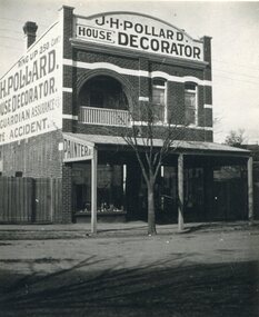 Surrey Hills Historical Society Collection
Photograph, Shop of J H Pollard, House Decorator, at 139 Union Road, Surrey Hills, 1930
This site was later occupied by Mitton's pharmacy. James Henry Pollard appears on the 1903 electoral roll as a painter in Canterbury Road (in one of the buildings that made up Hansen's Terrace.)The Union Road shops are covered by a City of Boroondara Heritage Overlay. This particular shop has changed very little with some alteration to the upper storey when it was repurposed for residential dwelling.Black and white photo of James Henry Pollard's shop at 139 Union Road, Surrey Hills in 1930. It is a 2 storey brick building with 2 glass display windows either side of the door and a corrugated iron roofed verandah supported on 3 posts. Above is a dwelling with 2 sash windows and an interior balcony within an arch. A wooden paling fence adjoins on the left. The side of the building and the front pediment carry advertising for the business. From this it appears that James Henry Pollard was an insurance agent for Guardian Assurance Company as well as being a house painter and decorator. There is a deciduous tree in the front of the shop.businesses, shops, mitton's pharmacy, guardian assurance company, union road shops, james henry pollard, painter, decorator -
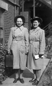 Royal District Nursing Service (now known as Bolton Clarke)
Photograph - Photograph, black and white:, 1948
These are the first two Malayan nurse recipients of an Australian Imperial Force Scholarship. This entitled them to spend three months with the Melbourne District Nursing SocietyNurses from Malaya came to Australia under the Australian Imperial Force (A.I.F) scholarship program.Black and white photograph of Malayan nurses, Miss Alice Chia and Miss Ooi Soh Im. Both Malayan nurses have dark short hair and are wearing glasses. They are wearing long grey coats which have collars and a belt, and dark brimmed hats. The nurse on the left is carrying an oblong case in her right hand and the one on the right has a white folded document in her left hand. They are standing on a path. Part of a brick building is to their left and rear, and a set of stairs is to the right rear. Part of a window can be seen to the left and some low bushes in front of the building. melbourne district nursing society (1885-1957), rdns, royal district nursing service, aif scholarship program, miss ooi soh im, miss alice chia -
 Charlton Golden Grains Museum Inc
Photograph, Dillon Building and Globe Hotel, High St Charlton c.1987, c.1987
Dillon Building built 1889. The third building operated as a cafe in the 1960s - 1980s. Heather's Choice Gift Shop sold out in early 1990s. The Old Globe Hotel established 1874, rebuilt c. 1903 and again in 1940 for licensee J. Credlin. Was the Soil Conservation Authority office , then flats and offices.Colour photograph of the café section of the Dillon Building and the Globe Hotel. LH side of the photo is the cafe section of the two storet, red brick Dillon building. Signage in LH café window reads CHARLTON BYO RESTAURANT and on the RH window MEALS, TAKE AWAYS, SNACKS, COFFEE, DRINKS. Sheer curtains in the cafe windows. The signage on the RH building reads SOIL CONSERVATION AUTHORITY. There are two men in a cherry picker in front of the Soil Conservation building trimming the tree. There are three witches hats on the road and a man in an orange hi-vis vest watching, A woman is walking past on the footpath.dillon, globe hotel, the old globe hotel, credlin, soil conservation authority, charlton, business, industry -
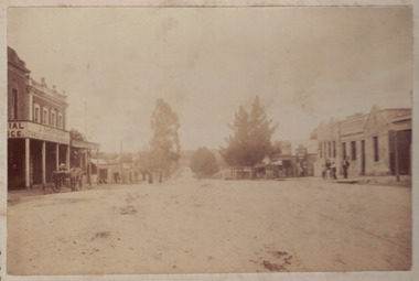 Linton and District Historical Society Inc
Photograph, Sussex Street, Linton, circa 1900
Sepia photograph mounted on grey card shows buildings in Linton's main street. On LHS of photo "J. Shepherd Grocer & Ironmonger", with horse-drawn cart outside. Railway Hotel, James Nelson Undertaker, and library buildings on RHS of photo, people standing outside hotel and children in front of undertaker's. Dating the photo: James Nelson, whose premises are shown next to the hotel, took over his family's carpentery and undertaking business in 1901. The original hotel was a timber structure or structures. It is believed these were removed in about 1903 and a new brick hotel built around 1903-1904.sussex street, linton, streetscapes, horse drawn vehicles, hotels, commercial buildings