Showing 6176 items
matching no. 100
-
 Kew Historical Society Inc
Plan - Subdivision Plan, Mount Ida Estate, 1925
The Kew Historical Society collection includes almost 100 subdivision plans pertaining to suburbs of the City of Melbourne. Most of these are of Kew, Kew East or Studley Park, although a smaller number are plans of Camberwell, Deepdene, Balwyn and Hawthorn. It is believed that the majority of the plans were gifted to the Society by persons connected with the real estate firm - J. R. Mathers and McMillan, 136 Cotham Road, Kew. The Plans in the collection are rarely in pristine form, being working plans on which the agent would write notes and record lots sold and the prices of these. The subdivision plans are historically significant examples of the growth of urban Melbourne from the beginning of the 20th Century up until the 1980s. A number of the plans are double-sided and often include a photograph on the reverse. A number of the latter are by noted photographers such as J.E. Barnes.The Mount Ida Estate was a subdivision of fifty-two residential allotments bordering Tooronga Road, Leura Grove, Constance Street, and Mount Ida Avenue in Hawthorn East. The report of the sale of the Estate in The Argus (21 September) claimed that over 1,000 people attended the auction and that all allotments were sold on the day. On the other side of Constance Street, the plan identifies the ‘Eastern Recreation Reserve’ (now Anderson Park).subdivision plans - hawthorn -
 Kew Historical Society Inc
Plan - Subdivision Plan, Jaques Estate, 1927
The Kew Historical Society collection includes almost 100 subdivision plans pertaining to suburbs of the City of Melbourne. Most of these are of Kew, Kew East or Studley Park, although a smaller number are plans of Camberwell, Deepdene, Balwyn and Hawthorn. It is believed that the majority of the plans were gifted to the Society by persons connected with the real estate firm - J. R. Mathers and McMillan, 136 Cotham Road, Kew. The Plans in the collection are rarely in pristine form, being working plans on which the agent would write notes and record lots sold and the prices of these. The subdivision plans are historically significant examples of the growth of urban Melbourne from the beginning of the 20th Century up until the 1980s. A number of the plans are double-sided and often include a photograph on the reverse. A number of the latter are by noted photographers such as J.E. Barnes.The Jaques Estate was a small subdivision of eight residential allotments bordering Jaques Street and Barkers Road in what is now Hawthorn East. Advertised in The Argus as being in ‘Upper Hawthorn’ the subdivision was claimed to include: ‘charming villa sites in excellent situations, with every convenience available, and with superior homes surrounding’.subdivision plans - hawthorn, jaques estate -
 Kew Historical Society Inc
Plan - Subdivision Plan, Houghton Street & Buchanan Avenue, Balwyn North, ca. 1906
The Kew Historical Society collection includes almost 100 subdivision plans pertaining to suburbs of the City of Melbourne. Most of these are of Kew, Kew East or Studley Park, although a smaller number are plans of Camberwell, Deepdene, Balwyn and Hawthorn. It is believed that the majority of the plans were gifted to the Society by persons connected with the real estate firm - J. R. Mathers and McMillan, 136 Cotham Road, Kew. The Plans in the collection are rarely in pristine form, being working plans on which the agent would write notes and record lots sold and the prices of these. The subdivision plans are historically significant examples of the growth of urban Melbourne from the beginning of the 20th Century up until the 1980s. A number of the plans are double-sided and often include a photograph on the reverse. A number of the latter are by noted photographers such as J.E. Barnes.A hand-drawn subdivision plan listing six blocks bounded by Houghton Street, Doncaster Road, Buchanan Avenue and Maud Street, North Balwyn. Written on the plan of subdivision are the lot numbers, the dimensions of the blocks and the price at which two lots were for sale or had been sold for.subdivision plans - balwyn -
 Kew Historical Society Inc
Plan - Subdivision Plan, Doona Estate, Toorak, 1929
The Kew Historical Society collection includes almost 100 subdivision plans pertaining to suburbs of the City of Melbourne. Most of these are of Kew, Kew East or Studley Park, although a smaller number are plans of Camberwell, Deepdene, Balwyn and Hawthorn. It is believed that the majority of the plans were gifted to the Society by persons connected with the real estate firm - J. R. Mathers and McMillan, 136 Cotham Road, Kew. The Plans in the collection are rarely in pristine form, being working plans on which the agent would write notes and record lots sold and the prices of these. The subdivision plans are historically significant examples of the growth of urban Melbourne from the beginning of the 20th Century up until the 1980s. A number of the plans are double-sided and often include a photograph on the reverse. A number of the latter are by noted photographers such as J.E. Barnes.The Doona Estate subdivision of 1929 created 11 new allotments bordered by Glenferrie Road, Stonnington Place, Cross and Church Streets. On the right of the plan, the location of ‘State Govt. House’ is noted. Stonnington was to be maintained as Victoria’s Government House until 1931, two years after the Doona Estate subdivision was released.subdivision plans - toorak, doona estate -
 Kew Historical Society Inc
Plan - Subdivision Plan, Auburn Heights Estate, 1921
The Kew Historical Society collection includes almost 100 subdivision plans pertaining to suburbs of the City of Melbourne. Most of these are of Kew, Kew East or Studley Park, although a smaller number are plans of Camberwell, Deepdene, Balwyn and Hawthorn. It is believed that the majority of the plans were gifted to the Society by persons connected with the real estate firm - J. R. Mathers and McMillan, 136 Cotham Road, Kew. The Plans in the collection are rarely in pristine form, being working plans on which the agent would write notes and record lots sold and the prices of these. The subdivision plans are historically significant examples of the growth of urban Melbourne from the beginning of the 20th Century up until the 1980s. A number of the plans are double-sided and often include a photograph on the reverse. A number of the latter are by noted photographers such as J.E. Barnes.The name ‘Auburn Heights Estate’, was handwritten on the subdivision plan, and included 23 lots in Auburn Road and Wright and View Streets, Hawthorn. Most of the houses built on the lots that were sold still exist. The house built on number 8 View Street is a contemporary exception. The subdivision included an existing home at number 17 View Street.subdivision plans - hawthorn, auburn heights estate -
 Kew Historical Society Inc
Plan - Subdivision Plan, Corsewall Estate, 1938
The Kew Historical Society collection includes almost 100 subdivision plans pertaining to suburbs of the City of Melbourne. Most of these are of Kew, Kew East or Studley Park, although a smaller number are plans of Camberwell, Deepdene, Balwyn and Hawthorn. It is believed that the majority of the plans were gifted to the Society by persons connected with the real estate firm - J. R. Mathers and McMillan, 136 Cotham Road, Kew. The Plans in the collection are rarely in pristine form, being working plans on which the agent would write notes and record lots sold and the prices of these. The subdivision plans are historically significant examples of the growth of urban Melbourne from the beginning of the 20th Century up until the 1980s. A number of the plans are double-sided and often include a photograph on the reverse. A number of the latter are by noted photographers such as J.E. Barnes.The Corsewall Estate was a subdivision, bordering on Barkers Road and Auburn Road, which created Corsewall Close. This relatively late subdivision included 29 allotments. The subdivision plan includes the dimensions of each lot as well as the width of the existing and projected roads and turning circles. The Corsewall Close Precinct is now listed on the Victorian Heritage Database (HO147) and is noted for its ‘consistent flat-type development over the entire street, which has been cleverly designed to make multi-unit dwellings appear as single buildings’.subdivision plans - hawthorn, corsewall estate -- hawthorn (vic.) -
 Kew Historical Society Inc
Plan - Subdivision Plan, Pointed Firs Estate, 1936
The Kew Historical Society collection includes almost 100 subdivision plans pertaining to suburbs of the City of Melbourne. Most of these are of Kew, Kew East or Studley Park, although a smaller number are plans of Camberwell, Deepdene, Balwyn and Hawthorn. It is believed that the majority of the plans were gifted to the Society by persons connected with the real estate firm - J. R. Mathers and McMillan, 136 Cotham Road, Kew. The Plans in the collection are rarely in pristine form, being working plans on which the agent would write notes and record lots sold and the prices of these. The subdivision plans are historically significant examples of the growth of urban Melbourne from the beginning of the 20th Century up until the 1980s. A number of the plans are double-sided and often include a photograph on the reverse. A number of the latter are by noted photographers such as J.E. Barnes.An almost identical plan of the ‘Pointed Firs Estate’ is in the State Library of Victoria. The plan unusually uses a photograph to show the panoramic views from the Estate. A prospective purchaser could expect to look across the Yarra Valley to Eaglemont and Heidelberg. The 36 lots advertised for sale faced Doncaster Road, Houghton Street, Maud Street and Thackray Street in Balwyn North.subdivision plans - balwyn, pointed firs estate -
 Kew Historical Society Inc
Plan - Subdivision Plan, Lodged Plan No.6518, 1920-1940
The Kew Historical Society collection includes almost 100 subdivision plans pertaining to suburbs of the City of Melbourne. Most of these are of Kew, Kew East or Studley Park, although a smaller number are plans of Camberwell, Deepdene, Balwyn and Hawthorn. It is believed that the majority of the plans were gifted to the Society by persons connected with the real estate firm - J. R. Mathers and McMillan, 136 Cotham Road, Kew. The Plans in the collection are rarely in pristine form, being working plans on which the agent would write notes and record lots sold and the prices of these. The subdivision plans are historically significant examples of the growth of urban Melbourne from the beginning of the 20th Century up until the 1980s. A number of the plans are double-sided and often include a photograph on the reverse. Reconciling this hand-drawn subdivision plan with a modern map of the area is initially a challenge due to a change of street names. Argyle Road in the centre of the subdivision was to be renamed Deepdene Road, and the street named Deepdene Road on the plan was to become Deepdene Place. Of interest is the nursery on the corner of Argyle and Whitehorse Roads. During this period there were a number of nurseries servicing the Kew and Balwyn areas. The subdivision was essentially of the land formerly occupied by the house 'Deepdene'.subdivision plans - balwyn, deepdene, whitehorse road -- deepdene (vic.), deepdene road -- deepdene (vic.), burke road -- deepdene (vic.) -
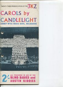 Vision Australia
Programme - Text, Twenty-third Presentation of the 3KZ Carols by Candlelight program 1960, 1960
Carols by Candlelight is a Christmas concert held at the Sidney Myer Music bowl. Programs and candle holders were sold, and collections made during the event to raise money for the Austin Hospital and the Royal Victorian Institute for the Blind. 3KZ also recorded the concert, which was played on radio on Christmas Day with a phone number to ring to donate. Prior to the Carols program at 9pm, the performance was opened by the Melbourne Lord Mayer and the process of torchbearers (100 girls dressed in white flowing dresses walk slowly in time with the music to the stage) as a prelude to the event.1 volume with photographs and illustrationscarols by candlelight, austin hospital, margot sheridan, lawrence warner, royal victorian institute for the blind, gwen bowdler, johnny o'keefe, norman swain, bernard evans, philip gibbs, norman k mcleod, syd morgan, dr charles bennett, harold stokes -
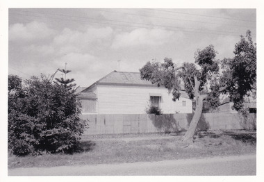
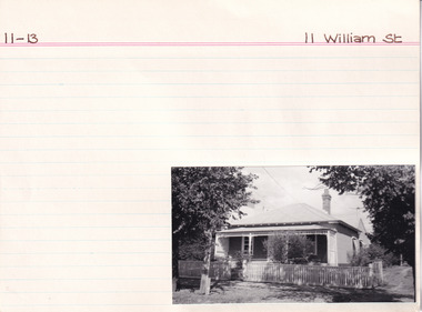 The Beechworth Burke Museum Research Collection
Card (Series) - Index Card, George Tibbits, 11 William Street, Beechworth, 1976
George Tibbits, University of Melbourne. Faculty of Architecture, Building and Town & Regional PlanningIndex system that support the research for Beechworth : historical reconstruction / [by] George Tibbits ... [et al]Arranged by street names of BeechworthEach index card includes: street name and number of property, image of property, allotment and section number, property owners and dates of ownership, description of the property according to rate records, property floor plan with dimensions.beechworth, george tibbitsbeechworth, george tibbits -
 The Beechworth Burke Museum Research Collection
Card (Series) - Index Card, George Tibbits, 14 William Street Beechworth (cnr Last St), 1976
George Tibbits, University of Melbourne. Faculty of Architecture, Building and Town & Regional PlanningIndex system that support the research for Beechworth : historical reconstruction / [by] George Tibbits ... [et al]Arranged by street names of BeechworthEach index card includes: street name and number of property, image of property, allotment and section number, property owners and dates of ownership, description of the property according to rate records, property floor plan with dimensions.beechworth, george tibbitsbeechworth, george tibbits -
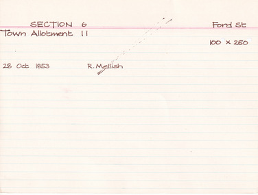 The Beechworth Burke Museum Research Collection
Card (Series) - Index Card, George Tibbits, Ford Street, Beechworth, 1976
George Tibbits, University of Melbourne. Faculty of Architecture, Building and Town & Regional PlanningIndex system that support the research for Beechworth : historical reconstruction / [by] George Tibbits ... [et al]Arranged by street names of BeechworthEach index card includes: street name and number of property, image of property, allotment and section number, property owners and dates of ownership, description of the property according to rate records, property floor plan with dimensions.beechworth, george tibbitsbeechworth, george tibbits -
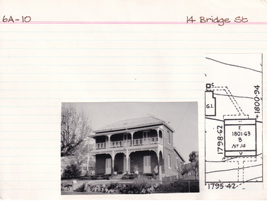 The Beechworth Burke Museum Research Collection
Card (Series) - Index Card, George Tibbits, 14 Bridge Street, Beechworth, 1976
George Tibbits, University of Melbourne. Faculty of Architecture, Building and Town & Regional PlanningIndex system that support the research for Beechworth : historical reconstruction / [by] George Tibbits ... [et al]Arranged by street names of BeechworthEach index card includes: street name and number of property, image of property, allotment and section number, property owners and dates of ownership, description of the property according to rate records, property floor plan with dimensions.beechworth, george tibbitsbeechworth, george tibbits -
 Melton City Libraries
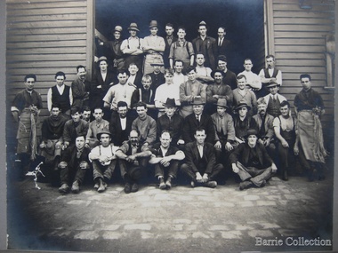
Photograph, 'Schutt and Barrie Flour Mill employees, Geelong Road West Footscray, Unknown
FORGING AHEAD City of Footscray City of Braybrook Incorporated 1959 Chaff Milling Section Interior photograph: Caption: Chaff baggers in operation Accompanying Text Schutt & Barrie Pty. Ltd. commenced operations in 1913 [Schutt]at Spotswood, but two years later a transfer was made to the present site at the corner of Geelong and Williamstown Road Footscray. The output for years past has been 100 tons of chaff a day- the largest of any mill of its kind in Australia. The firm’s “Green String” is widely known.Schutt & Barrie workmen with John Ralph Schutt and C E Barrie.local identities, agriculture -
 Whitehorse Historical Society Inc.
Equipment - Camera, 1978
Minolta Pocket Autopak Camera with a Pocket Flash 110 attached and cover.Three pieces in total. It was made 1978 with a 26mm (f3.5) zone focusing (1.6 feet to infinity) lens. Electronic shutter with speeds of 2 seconds - 1/1000. CDS meter provides programmed exposure control. Hot shoe. Tripod and cable release sockets. Built-in close-up lens and detachable flash. Viewfinder shows a red warning LED if a flash is needed. With the f:3.5 lens, a flash with a guide number of only 40 (in feet, at ISO 100) will be good to over 20 feet with ISO 400 film. The camera senses when a flash unit is mounted, and automatically sets smaller apertures for focus distances of 12' or less, to prevent . overexposure, assuming a fixed-output flash with a guide number of 40. Built-in sliding lens cover locks shutter. This is the most compact of the high-quality Minolta 110 pocket cameras (handy, very small pocket size, overall 1 x 2 1/8 x 4 5/8'), it is truly a dress-shirt-pocket camera, not just a coat-pocket camera. 100 or 400 speed film. Needs two MS76 or EPX76 or equivalent; battery-check button.Minolta Autopak 470 - Pocket Flashphotography, cameras -
 Melbourne Tram Museum
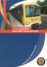
Magazine, Rail Tram & Bus Union (RTBU), "Newsline - 2008 New Year Edition" , "Newsline - 2007 New Year Edition", 2006
.1 - Magazine - A4 - 20 pages including light card covers, full colour, centre stapled titled "Newsline - 2008 New Year Edition", published by the RTBU - Rail Tram and Bus Union Christmas 2007. Contains reports from Union officials including Phil Altieri Assistant Secretary , Lou DiGregorio - Secretary and Doug Brady, President of the Tram and Bus division. Gives contact details. Photos supplied by Yarra Trams and Metlink. Has adverts for Southern Cross Station, Slater & Gordon, Consultum financial advisors, Members Equity bank, Connex, VLine, Metlink, RTBU Holiday units, Mainco, Transport Health Fund, Retired Railway Employees Association of Vic and Retired Tramway Employees Association of Vic. - President Joyce Spark, Secretary Dot Micallef, Yarra trams, Austral Credit Union and a services directory. For Calendar see Reg Item 1182. .2 - as above - 2007 edition, with additional Officers reporting. Has front cover photo of the Siemens 100 years of trams on the front cover, and a poster for the event on the inside front cover. On page 14, has a photo of retired trammies at Essendon Depot during the 100 years celebrations. Has adverts in addition to above for Australian Super, Safeworking solutions (Rail Safety).trams, tramways, yarra trams, rtbu, unions, essendon, 100 years of electric trams -
 Kiewa Valley Historical Society
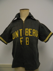
T-Shirt - Mt Beauty Fire Brigade x2
Mt Beauty rural fire brigade was established in 1948 by the State Electricity Commission of Victoria as an industry brigade. When Mt Beauty was handed over to the Shire in 1961, the fire brigade became a member of the Country Fire Authority (C.F.A.). Today it is an urban fire brigade. The t-shirt would have been used when members were together during fire drills, competitions, meetings etc. The black shirt was used prior to 1950 and the Red shirt was used after March 1950 The red t-shirt was used in the following yearThe t-shirt was part of the Mt Beauty fire brigade uniform indicating that the fire fighters were part of a team and were able and wanted to be recognised. It also indicates a strong and popular organisation. Black thick cotton t-shirt with collar and short sleeves. A zip is at the top front. Sleeves have yellow strip near their opening. "Mount Beauty F B" has been zig zagged stitched onto the front, also in yellow. Red thick cotton t-shirt with collar and short sleeves. 2 buttons at the top front. Sleeves have a yellow strip near their opening."Mount / Beauty" has been zig zagged stitched onto the front, also in yellow.Tag inside back under collar - "Sportswear / Simpson / of Melbourne / Mr - then P.A.B. handwritten in space provided. also '36' and 'All cotton' tags attached. Tag inside back under the collar - "Haworth Knit / Glen Iris, Melb./ 100% Cotton"mt beauty; fire brigade; clothing; state electricity commission of victoria -
 Glenelg Shire Council Cultural Collection
Book, George L. Chalk and Charles MacFarlane and other contributors, The Pictorial History of England, Vol. VII1, 1802-1815, 1846
Light brown coloured leather-bound spine and cover corners. Paper-covered board covers with greens red and ochre marbling. Gold lettering and gold graphics on spine. -
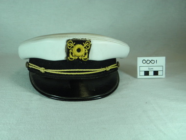 Raymond Island Historical Society
Ferryman's Cap, Mid 19th Centuary
Raymond Island Ferry Driver's Cap issued by Shire of Bairnsdale with new ferry in March 1969 Issued to Ferry Driver George BouldOnly cap in existenceOfficer peak cap White plastic with black leather peak and band Gold cord insignia Gold and Black embroidered Lifebuoy and anchor badgeManufacturer's plate 1 Underside of cap MELBOURNE 361218 EMERCO Oval Trademark with kangaroos each side REG TRADEMARK THIS IS YOUR GUARANTEE FOR QUALITY MADE IN AUSTRALIA Manufacturer's plate 2 Front inner brim SWEAT ABSORBER TEXTILE 100% SWEATPROOF raymond island ferry, ferry driver, ferryman, ferryman s cap, 1969 -
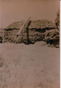 Hume City Civic Collection
Photograph, c1934
A sepia photograph of a haystack being built with a bale elevator at the side and a hay cart at the end at Bayview Farm.on back in ink: HAYSTACK AT 'BAYVIEW'/ABOUT 1934 / 60' (feet) long, 20' (feet) high, 25' (feet) wide / ELEVATOR APPROX 25' (feet) long / 70-100 tons of hay / "Bayview" / 111 DAVIS ROAD / DIGGERS REST 3427cullinan, uraina, eileen, chris, bayview farm, diggers rest, farms, farming, clothing and dress, harvesting, haystacks, george evans collection -
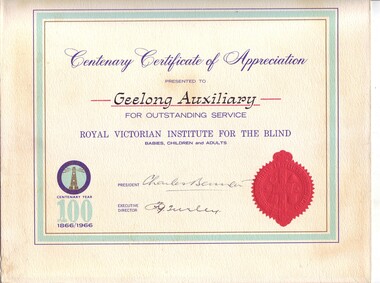 Vision Australia
Administrative record - Text, RVIB Geelong Auxiliary papers, 1933 - [1998?]
The Geelong RVIB Auxiliary was formed on February 13, 1933 by Mr Birtchnell. This collection of papers includes the minute books from 1944 until 1998. It was noted in correspondence that Geelong and surrounds had been the most outstanding financial contributor to RVIB's revenue. Collections from the Geelong community had provided high donations every year. The Geelong Auxiliary posted 301 pounds on their first return in 1934, easily topping any of the other 200 auxiliaries in the state at that time. The Annual Report from July 31, 1995 noted that with regret due to health reasons and the passing of many members The Geelong RVIB Auxiliary had no option but to go into recess. The certificate reads: Centenary Certificate of Appreciation presented to Geelong Auxiliary for outstanding service. Royal Victorian Institute for the Blind babies, children and adults. (Signed by) President (Charles Bennett) Executive Director (F.G. Turley).5 minute books -- 2 accounts books -- 1 book of newspaper clippings --various loose papers and letters -- 1 certificate of appreciation Certificate: white paper with light turquoise thick border and gold and blue thin borders. The RVIB official seal is at the base of the right hand side and a coloured image of the RVIB logo, with the words 'Centenary year 100 1866/1966' in the bottom left corner.royal victorian institute for the blind, auxiliaries -
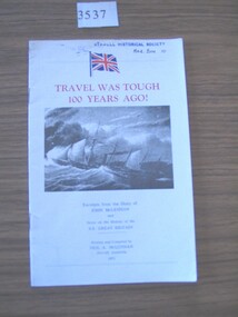 Stawell Historical Society Inc
Book, Neil A. McLennan, Travel was Tough 100 Years Ago!, 1971
Excerpts from the Diary of John McLenna and Notes on the history of S.S. Great Britain.White card cover, Union Jack Flag, Red Print B/W photo of a sailing ship in heavy seas below which is more print Black.Travel was Tough 100 years Ago! Excerpts from the diary of John McLennan and Motes on the History of S.S Great Britain Written and complied by Neil A. McLennan Stawell, Australia 1971. On Last Page in blue ink: From - Estate Ruby Willy 1998stawell transport -
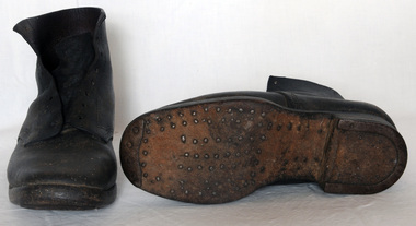 Orbost & District Historical Society
boots
Hobnailed boots are boots with hobnails (nails inserted into the soles of the boots), usually installed in a regular pattern, over the sole. They also usually have an iron horseshoe-shaped insert, called a heel iron, to strengthen the heel, and an iron toe-piece. The hobnails project below the sole and provide traction on soft or rocky ground and snow, but they tend to slide on smooth hard surfaces. They may also have steel toecaps. When Army boots were made 100% of leather, to get some grip on the soles hob-nails were hammered into them. These boots are an example of the foot wear worn by the eA dark brown leather pair of very heavy hob-nailed boots. They have nails inserted into the soles of the boots in a regular pattern, over the sole. The toes and the heels have been strengthened with metal. The boots are made to lace up at the front.boots-hobnailed footwear -
 Warrnambool and District Historical Society Inc.
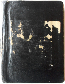
Book - Diary, Diaries of John Ward Vol 1 & Vol 2
They are the handwritten history of Methodism in Warrnambool (produced in the 1930s?) by John Ward, and early settler, North Warrnambool shopkeeper and an ex-councillor and mayor. The books contain over 100 original photographs of people connected to the Methodist Church, both clerical and lay, including women, and other Warrnambool photographs. There is also much written material on all the people connected to the church. The books were given to Warrnambool & District Historical Society Inc in March 2013 by the Uniting Church together with DVD with a digital copy of the photographs and a typed copy of the writings. [Elizabeth O'Callaghan, March 2013]Exercise books: History of Methodism in Warrnambool by John Ward Cat No: WARR These two black exercise books are most precious as they are of high historical significance. They provide an insight into the social and spiritual history of the methodists in Warrnambool Vol 1: 265pp Vol 2: 180pphistory of methodism in warrnambool, john ward -
 Warrnambool and District Historical Society Inc.
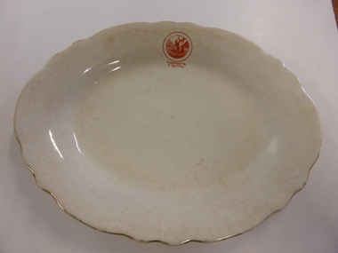
Plate Pottery, Serving Plate Parramatta, Late 19th century
The settlement of Parramatta is one of the earliest inland settlements in Australia being settled in November 1788 just months after the arrival of the First Fleet to Sydney. Originally named Rose Hill it was given the name Parramatta which closely approximated the original Aboriginal name for the area. Being within a reasonable distance to the settlement of Sydney and in an area of fertile soil, it soon became a successful farming region. It was proclaimed a city in 1938. This plate possibly belongs to either the commemoration of 100 or 150 years of settlement of the area, although the stamp on the plate is the same drawing as that on the official invitation for 1938While this plate has no local historical links , it does have significance belonging to one of the earliest settlements in Australia.White oval plate with fluted edge with gold on rim. Small orange stamp on one edge.Parramatta 2 Nov 1788 on one edge of plate. Stamp on back: Grimwades Staffordshire England Upper Hanley Pottery. Semi porcelainwarrnambool, parramatta, serving plate -
Warrnambool and District Historical Society Inc.
Domestic object - Bean Slicer, Spong & Co, England, c.1920
This bean slicer was made about the 1920s by the British firm of Spong & Co. This firm was founded by James Osborn Spong in 1856 in London. James Spong invented over 100 labour-saving devices during his lifetime and his firm became well-known for its production of domestic labour-saving and safety devices, especially its grinding machine and its bean slicer. These domestic items were to be found in most households from the 1880s to the 1950s prior to the advent of electrical items that carried out similar labour-saving processes. This bean slicer is of interest as a reminder of the many labour -saving devices that were available to most women early in the 20th century, even those in the rural and more remote areas in AustraliaThis a heavy metal bean slicer with a circular piece with a rounded cut-out at the top for the insertion of the bean and an attached bolted handle with a wooden top. Attached to the circular top is a circular revolving piece with three cutters. Welded on to the top piece is a metal clamp with a large screw for attaching the slicer to a table or bench. The slicer is painted green and has the name of the manufacturer etched on the top piece.Spong & Co Ltd Made In England No 632 Bean Slicervintage bean slicers, spong & co london, vintage household items -
 Warrnambool and District Historical Society Inc.
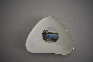
Artefact, Alka, Dish, Mid 20th century
This souvenir dish has been made by the German firm of Alka. The name comes from the surnames of the two proprietors, Alboth and Kaiser. This type of dish was made between 1938 and 1958. Tourism has been an important industry in the Warrnambool area for over 100 years and souvenir dishes of this kind were a popular buy by the visiting tourists. The dish features a scene from the Hopkins River, a fishing and recreational area in Warrnambool since the early days of European settlement. Souvenir dishes such as this one can be sometimes found in local second hand and opportunity shops. This dish is of interest as an example of the high-quality souvenirs bought by local tourists in the Warrnambool area in the mid 20th century.This is a china dish made in a rounded-edged triangular shape. The rim is gilt-edged. In the centre of the dish is a coloured sketch/photograph of the Hopkins River in Warrnambool (Clifton Banks region). ‘Warrnambool Hopkins River’ ‘Alka Bavaria Germany’ tourism in warrnambool, hopkins river, warrnambool, history of warrnambool -
 Eltham District Historical Society Inc
Document - Series Listing, Fraser Faithfull et al, Series 13: Eltham Shire Photograph Album 1985, 2000
Series consists of 174 colour and B&W photographs of sites and activities in the Shire of Eltham. Most shots are 150mm by 100, though there are a number of smaller shots laid out in montages, and 6 large (A4 size) colour shots. Subjects documented include the Eltham Library, Eltham Lower Park, Eltham Senior Citizens Centre, Housing Development, the Council Depot, Shire Offices, Eltham Child Care Centre, Miniature Railway, Community Centre, the Bike Track, a Citizenship Ceremony, Shillingham Cottage, Eltham Town Park and other sites.shire of eltham archives, series listing -
 Eltham District Historical Society Inc
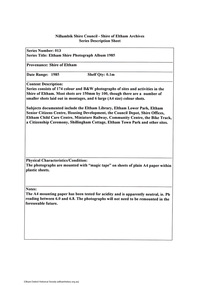
Newspaper - Newspaper articles, Sun News-Pictorial, Fire Kills 3, The Sun News-Pictorial, Thursday, March 4, p1, 1965
Various news articles pertaining to the January 1965 Victorian bushfires specifically with a focus on fires at Eltham North. Specific Eltham Shire districts mentioned include Eltham North on page 1, 2, 3, 28-29 • Fire Kills 3, p1 (Illust.) • Fire on their heel, p2 (Illust.) • Flames catch, kill 3 as they run: 12 house go, p3 (Illust.) • It doubled back, p3 • Helpers highly praised, p3 • Blaze kills 100 puppies, p3 (Illust.) • Scenes from Eltham’s Black Wednesday, pp28-29 (Illust.) tom fielding collection, victorian bushfires - 1965, victorian bushfires – 1965, glen park road, eltham north, sunny pine, bushfire damage – buildings, back gully, gippsland, glenmaggie, briagolong, george john crowe, john lawrence coleman, william john elwers, creek road, wattle glen, bill guy -
 Ballarat Clarendon College
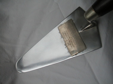
Trowel, prior to September 1956
The trowel was used by Dr W A Sloss when he set the foundation stone for the new boarding school wing at Clarendon College, Webster Street site, on 22 September 1956. The builing of this wing enabled up to 100 boarders to be accommodated on the Webster Street property. Dr Sloss had been one of the school trustees; at the time of the building project he was Deputy Chairman of the school Council; he was also the school medical advisor for many years. His duagters and grand-daughters attended Clarendon College. Sloss House was named after him.Silver-plated trowel with wooden handle; plaque attached to trowel platePresented to/ Dr. W. A. Sloss (MBE)/ on laying the/ foundation stone/ Clarendon College/ - Boarders Wing - /Sept.22nd, 1956clarendon presbyterian ladies college, foundation stone, dr w a sloss, clarendon presbyterian ladies college boarders wing, 1956