Showing 8509 items
matching snowy-river-dry-cleaners
-
 Bendigo Historical Society Inc.
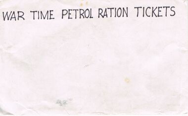
Ephemera - G ALICE JONES COLLECTION: ENVELOPE, 1941/1945
G. Alice Jones Collection; Envelope. Hand printed in black ink on a white envelope is "War Time Petrol Ration Tickets". The envelope is lined inside with blue ink. On the back is strips of dry glue for sealing. Box 625petrol ration tickets -
 Port Melbourne Historical & Preservation Society
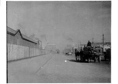
Photograph - Horse and cart, Normanby Road, 1930s
Lasercopy of photograph of horse and cart in Normanby Road, c late 1930s, looking southwest toward Port Melbourne from opposite the dry dock and showing railway sheds on the left and in the distance, Laconia Woollen Mills with Dunlop opposite.transport - horse, dunlop, laconia woollen mills -
 Bendigo Historical Society Inc.
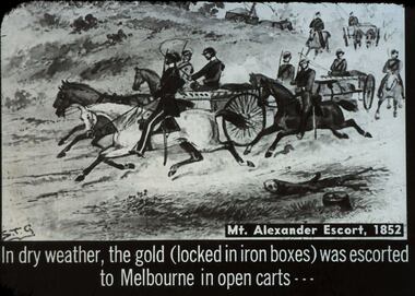
Slide - DIGGERS & MINING. THE GOLD LICENCE, c1852
Diggers & Mining. The gold licence. The Government Camp. Mt Alexander Escort, 1852. In dry weather, the gold (locked in iron boxes) was escorted to Melbourne in open carts. Markings: 22 994.LIF. 4. Used as a teaching aid.hanimounteducation, tertiary, goldfields -
 Kew Historical Society Inc
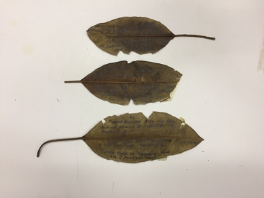
Plant specimen, Dorothy Rogers, Inscribed Moreton Bay Fig Leaves, Hawthorn (Vic), c.1960s
Collected by the historian Dorothy RogersDried Moreton Bay fig leaves from the vicinity of Palmer's Punt near Denham Street Hawthorn. Each leaf was inscribed by the historian Dorothy Rogers (sic) before 1973. The leaves are brittle and undated, with the text difficult to decipher. 1974.0010.1 "Moreton Bay fig leaf from old tree foot of Derham St Haw - vicinity Palmer's Punt until 1934 flood & hut for Punt passengers was still there. KH-355." 1974.0010.2 "Moreton Bay fig leaf from old tree foot of Denham St haw - vicinity Palmer's Punt until 1934 flood hut for punt passengers still existed there. A canoe tree in garden from Sir J. Palmer's land. KH-355." 1974.0010.3 "Moreton Bay fig leaf from old tree foot of Denham St leading to Palmer's Punt until 1934 flood there was still there a hut for punt passengers. Canoe tree in gardens from Sir J. Palmer's land. KH-355."denham street - hawthorn (vic), palmer's punt, invergowrie - hawthorn, 1934 flood - melbourne - hawthorn (vic) -
 Sunbury Family History and Heritage Society Inc.
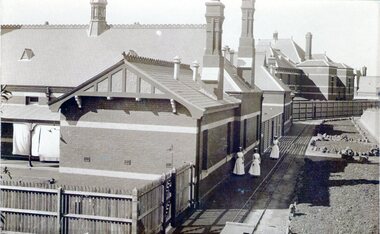
Photograph, Sunbury Asylum, c1920s
The brick buildings in the photograph are of the former Sunbury Asylum and F3 Ward is in the foreground. Initially the site on Jackson Hill also known as She0ak Hill opened as an Industrial School for orphaned or neglected children and in 1879 it became an asylum where it continued to function as an asylum until the Victorian Government closed it on 20th November 1992.The Sunbury Asylum played an important part in Sunbury and wider community's development over 150 years. throughout its existence there was much interaction between the residents, staff and local community, many of whom were employed at 'The Hill' as it was known locally. A sepia non-digital photograph of a large brick hospital building with three nurses standing outside it on a narrow pathway edging a garden bed. A picket fence is at the rear of the building enclosing a small yard where washing is drying on the line.sunbury asylum, jackson hill, caloola, sheoak hill, ward f3 -
 Orbost & District Historical Society
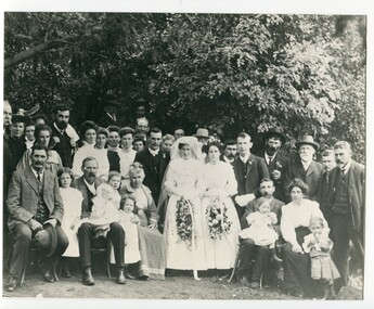
black and white photograph, April 15 1909
This photograph shows the wedding of Maggie (Fran Margaret) Middleditch form Murrangowar to Frank Day who worked in the local saddler's shop. An article in the The Snowy River Mail and Tambo and Croajingolong Gazette : ORBOST PETTY SESSIONS. 8 April 1909 Constable O'Shannassy proceeded against Frank Day on a charge of being unlawfully in possession ol four kangaroo skins. Frank Merson Day was born in 1887 and died 1950. he was the son of George Seears Day and Annie Grose He and Maggie had four children : Eileen Margaret Annie Day; Francis Day; Anne Day and Frank Day. This is a pictorial record of a social event in Orbost in the early 20th century. Those recorded have connections to Orbost.A large black / white photograph of a wedding party. The bride and groom are surrounded by family. Some are seated and most standing in front of some tall trees. There is a photocopy with a list of those in the photograph.on back - "Mary Gilbert"day-frank middleditch-maggie -
 Orbost & District Historical Society
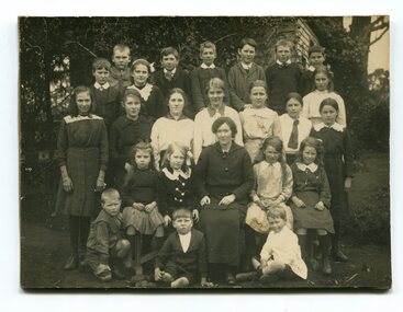
black and white photograph, C1910
This photograph shows a class of students with a teacher from the Jarrahmond School around 1910. Jarrahmond State School, 2745, which opened on 19th of March 1 886 with Campbell Mackay as head teacher operated on a part-time basis with State School 2744 Orbost, which opened at the same time. The first building, erected on the bank of the Snowy River, was moved in approximately 1892 to McLeod's Lane. In 1914 a new building was erected by George Lurkins, and this catered for the local children until a school bus service took them to Orbost in 1949. The school building was transferred also and became an integral part of State School 2744 Orbost. This photograph is associated with the history of education in the Orbost district.A black / white photograph of a lady seated with three rows of children around her. the photograph has been taken outside a wooden building.on back - Jarrahmond School 23 years ago.jarrahmond-state-school education-orbost -
 Orbost & District Historical Society
book, Vic Roads Centenary 1913 -2013, 2013
The publication, VicRoads Centenary: Keeping Victorians Connected for 100 Years, looks at the people and projects that define VicRoads’ history. Written by current and former VicRoads’ employees, the publication details the organisation’s portfolio of major projects, which includes the Great Ocean Road, Hume Highway and Eastern Freeway. Other sections report on Victoria’s world-first road safety initiatives, VicRoads’ use of technology and sustainability measures. (ref VicRoads) This item is one of several books donated by David Jellie at a presentation to Orbost Historical Society. He was a contributor to the book and was the engineer for the Snowy River Bridge (Princes Highway) at Orbost 1974-1976.This book is a useful reference tool on the history of road construction in Victoria including East Gippsland.A thick, bound paperback book, titled "VicRoads Centenary Keeping Victorians Connected for 100 Years". On the front cover is a black/white photograph of two men working on a road. One has a pick. The book contains the history of VicRoads, photographs, maps and advertisements. Some are b/w. Others are coloured.vicroads book roads snowy-river-bridge jellie-david -
 Morongo Old Collegians
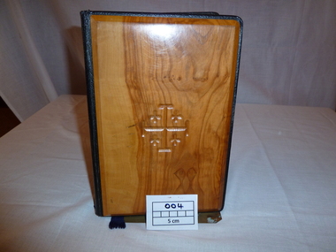
Book, Holy Bible, 1958 (estimated)
Also contains two cards: (1) with dried flowers from Jerusalem, and (2) from Bethlehem Before it came to Morongo it was jused in Bethlehem, Nazareth and Titerus (Sea of Galilee).The Holy Bible contains the Old and New Testaments and is the authorised King James Version. It contains numerous maps showing 'The Ancient World, Canan, Journeys of Children of Israel, Ancienct Jerusalem, Herod's Temple, etc.' The front and back covers faced in wood from the olive tree.Presented to "Morongo" by Margaret L. Toyne, 16/11/63 in appreciation for my School Years. Bought for the School, used in Bathlehem, Nazareth, Titerus (Sea of Galilee).'book, education, school, morongo, geelong, girls, boarding, presbyterian, uniting, history, assembly, private-girls-school, lucy-shaw, gertrude-pratt, dulcie-brookshaw, 1920-1994, kindergarten-year-12, holy-bible -
 The Beechworth Burke Museum
Photograph, 1997
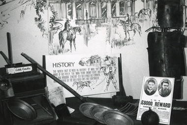
This photograph is recorded as having been taken in the North East Victoria Regional Tourist Authority, Wangaratta and depicts an exhibition display of items and interpretative labels associated with the Kelly Gang. The display was reportedly laid out as part of a Vic Tour Stamp, with items from the Burke Museum Collection.This photograph is of social significance due to its connection with the Burke Museum as well as the Kelly Gang. The Kelly Gang story is integral to the formation of the Australian identity and highlights the Irish oppression during the 1880s. Ned Kelly is an Australian icon, mythologised in Australian literature, art, folklore and history, and the Kelly Gang permeates Australia's national consciousness. The significance of the Burke Museum is also highlighted here, as the photograph shows the importance of the Kelly story to the Beechworth area and local identity, as well as its significance within the museum collection. The photograph is of strong research potential due to its depiction of the Kelly Gang history in Australia and its presentation of a historical museum exhibition which toured from Beechworth to other Victorian locations. With a depiction of the exhibition and associated label, the photograph provides insight into how the language and historical interpretation of Kelly Gang has developed, and how cultural and social opinions which are often shaped by exhibition displays, have shifted. Black and white rectangular photograph printed on matte photographic paper.Obverse: Gold Cradle / History / Claim 1835 / The north east is rich in history. It was the home of Ned Kelly, the 'Man from Snowy River' and (???) dog Mogan. Century old buildings are common and (???)nders of the gold rush days are everywhere / V. R. / £8000 Reward / Robbery and Murder / (indeterminate) Reverse: The historical display laid out in VICTOUR / 1997 3135 / North East Victoria/ Regional Tourist Authority/ P.O. Box 250/ Wangaratta. 3577 /BMMA03324burke museum, ned kelly, kelly gang, museum collection, exhibition, display, gallery, museum, exhibit -
 Ballarat Tramway Museum
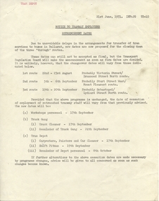
Administrative record - Memorandum, State Electricity Commission of Victoria (SECV), "Notice to Tramway Employees - Retrenchment Dates", 21/06/1971 12:00:00 AM
Yields information about the planning for the closure of the tramway system in Ballarat by the SEC and the way the retrenchment of staff would be arranged., Yields information about the planning for the closure of the tramway system in Ballarat by the SEC and the way the retrenchment of staff would be arranged.Duplicated quarto sized memorandum titled "Notice to Tramway Employees - Retrenchment Dates", dated 21 June 1971, giving advice of the possible change over dates and likely termination dates for Workshops personnel, Track cleaner, track gang and depot staff. Has "Tram Depot" typed in top left hand corner.trams, tramways, closure, ballarat, sec, depot -
 Kew Historical Society Inc
Photograph - John Duncan Brownlee and friends, Yarra River, The Artorium, 1920s
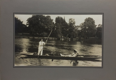
This mounted and framed photograph of a group of friends punting on the River Yarra has a number of historic and artistic associations. The photograph is primarily important as an informal photograph of the Australian baritone John Donald Mackenzie Brownlee (1900-1969), whose international career at the world's major opera houses from 1927 until his retirement in 1958 included singing at Melba's Covent Garden farewell in 1926, to recordings in the 1930s of a major series of Mozart operas in Glyndebourne Festival productions, conducted by Fritz Busch. Brownlee, born in Geelong, won the gold medal as champion vocalist at the South Street competitions in Ballarat in 1921. Moving to Paris in 1923 he began study with the French baritone, Dinh Gilly, making his operatic debut at the Trianon Lyrique in Montmartre in 1926. The most significant periods of his operatic career were with the Paris Opera from 1927 to 1936, and at the Metropolitan Opera from 1937 to 1957. After his move to Paris in 1923, he is recorded as revisiting Australia in 1928 as a member of the Melba-Williamson Company, and 24 years later in 1952. The photograph of Brownlee and the Gardners in a punt on the Yarra, while putatively dated to 1925, must be from earlier in the 1920s before his move to Paris, or later during the Melba-Williamson Company season. Before his move to Paris in 1923, Brownlee had lived in Belmont Avenue, Kew, where he must have developed a friendship with the Gardners. The photograph has additional artistic significance as it was produced at 'The Artorium', James Beament's design studio next to the Hawthorn Town Hall at 362 Burwood Road. With a home at 33 Uvadale Road (designed by Eric Nicholls, who managed the architectural practice of Walter Burley and Marion Mahony Grifffin from 1924 to 1932), Beament painted a number of significant murals for the Griffin practice, including those at the Capitol Theatre in Melbourne.A photograph of recreational activities on the River Yarra. The photograph is historically significant as a professionally produced photograph of the Australian operatic baritone John Brownlee, either before his move to Paris in 1923, or in 1928 during the Melba-Williamson Company operatic tour of Australia. The photograph has additional aesthetic significance as it was produced in James Beament's Hawthorn Studio - The Artorium - at 362 Burwood Road, next to the Hawthorn Town Hall.Framed photograph of John Duncan Brownlee, the Australian tenor, with Enid Gardner and friend in a punt on the Yarra River. Brownlee was born in Geelong but before his move to Paris in 1923, he lived for a period in Belmont Avenue, Kew. Three labels on reverse. 1. "John Duncan Brownlee, Operatic Star, originally of Geelong later resident of Kew at Belmont Av, on the pole. Also in the punt - Edith Gardner a friend. The Gardners lived on the east corner of Edgevale Rd. & Cotham. Approx. 1925." 2. "This picture is the property of Kew Historical Society 1/4/79". 3. Tel. Hawthorn 842 THE ARTORIUM ...."john brownlee (tenor), punting, recreation - yarra river (kew), james beament, the artorium -- 362 burwood road -- hawthorn (vic.) -
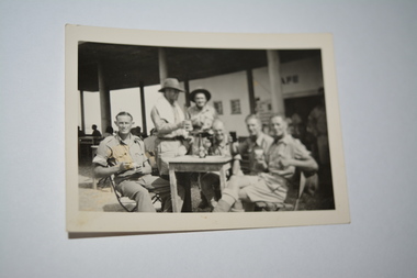 Wangaratta RSL Sub Branch
Photograph
Photograph of group of soldiers (2/5 Aust Inf Bn) on leave at unknown locationBlack and white photograph of six soldiers sitting at outside cafe tableHandwritten in green on rear "boys were on three day tour at the time" Joe Foley "Bull" Allen, Hugh....Snowy Clark, Geo.Finch and Alf Hugh sends them with his kindest regards2/5th aust. inf. bn, ww2 -
 Orbost & District Historical Society
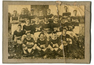
black and white photograph, 1906
Before official competition began in 1894, scratch matches were held in the Old Station paddock. The Orbost football club players were known as the Busters and wore green and gold guernseys. An Orbost football team has participated in the East Gippsland League since the early 20th century. In 2003 in response to a dwindling population, the Snowy Rovers and Orbost Football Clubs were driven to merge into the Orbost Snowy RoversFootball clubs, through their many changes, have always been an important social fabric of the community. Sport is often regarded as an important part of life in rural Australia, contributing to community identity, sense of place, social interaction and good health.A large black / white photograph on a cream coloured buff card. It shows three rows of men, one seated, dressed in football uniforms. The photograph has been taken outdoors.There are three copies.on front - "Orbost Team 1906" There is a list of names.sport orbost-football recreation -
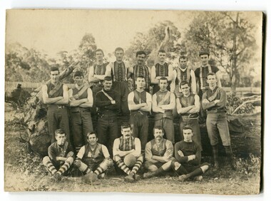
 Orbost & District Historical Society
black and white photograph, 1921
The Orbost Football Club began in 1894. This photograph shows the premiership team of 1921.They defeated Buchan. The Orbost football club players were known as the Busters and wore green and gold guernseys. An Orbost football team has participated in the East Gippsland League since the early 20th century. In 2003 in response to a dwindling population, the Snowy Rovers and Orbost Football Clubs were driven to merge into the Orbost Snowy RoversFootball clubs, through their many changes, have always been an important social fabric of the community. Sport is often regarded as an important part of life in rural Australia, contributing to community identity, sense of place, social interaction and good health.A black / white photograph of three rows of men in sports clothes The back row is standing, the middle sitting on chairs and the front row sitting on the ground.. All men have their arms folded and the photograph has been taken outside. The photograph has been pasted onto a grey buff card.on front - "Orbost Football Club Premiers - 1921" on back - 'Mary Gilbert"orbost-football-club recreation sport -
 Wodonga & District Historical Society Inc
Album - Hume Reservoir Australia Album - View from the Victorian bank of the Murray River, May 1923
This set of photos is from a leather bound album bearing the inscription "HUME RESERVOIR AUSTRALIA" plus 'The Rt. Hon. L. C. M. S. Amery, P. C., M .P.' all inscribed in gold. It was presented to The Rt. Hon. L. C. M. S. Amery, P. C., M. P, Secretary of State for Dominion Affairs on the occasion of his visit to the Hume Reservoir on 2nd November 1927. This album is of local and national significance as it documents the planning and development of the Hume Reservoir up to 1927. It was the largest water reservoir in the British Empire. The album records the pioneering engineering work that went into its construction.DEPARTMENT OF PUBLIC WORKS, N.S.W. RIVER MURRAY WATERS SCHEME. HUME RESERVOIR. 12. View from the Victorian bank of the river showing in the foreground a levee bank along the New South Wales side of the river with connecting wings back to the higher ground, May 1923. The first stage in the construction of the Dam foundations was carried out inside the levee bank which was at a sufficient height to protect from floods the work going on inside. A length of 300 feet of the Dam was left at a low elevation to allow of the river flowing over it in the second stage of the operations and at the ends of the concrete was brought up above flood level. To divert the river, a Coffer Dam was built across the old bed above and below the Dam site and tying into the end of the concrete wall built inside the levee bank. This completely surrounded the remainder of the site of the Dam and south wing wall, including an area of 12½ acres.hume reservoir australia, river murray waters scheme, hume reservoir construction -
 Bendigo Historical Society Inc.
Postcard - GLADYS DEAN COLLECTION: POSTCARD, 1906 - 1908
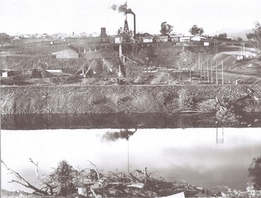
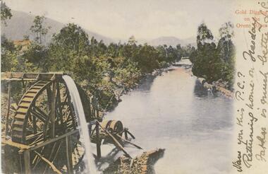
Coloured photographic postcard with a 2cm white border on right hand side depicting gold digging on the Ovens River. Aspect is taken from behind a waterwheel with a man standing on a platform looking over the river. The banks are thickly treed and mountains can be seen in the distance. The words Gold Digging on the Ovens River are printed in red on the margin and handwritten in black are the words Have you this PC? Returning home on Tuesday Father is much better L.C. On the reverse card is addressed to Miss R Dean 'Esmond" Golden Square Bendigo.44140postcard -
 Kew Historical Society Inc
Photograph - Macauley's, Kew, 1924
Henry Beater Christian (1886-1962) , was a descendant of one of the earliest settler families in Kew. Employed at the Kew Asylum as a 'public servant', he was a skilled amateur photographer, photographing numerous scenes in Kew and on his travels around Victoria. The majority of his photographs date from 1916 to 1929. His finest photographs are housed in two photograph albums. A very rare, early panoramic view of Macauley's boat house on the Yarra River at Kew.Digital copy of a photograph from page 2 of the 47-page photograph album containing 261 gelatinous silver images, loaned by Diane Washfold with permission given to digitise and hold a copy in our collection. The photograph is of Macauley's boat sheds on the Yarra River at Kew. The boat sheds was located at the west end of Molesworth Street. The photograph is taken from the Yarra Bend Park side of the river looking down on the boat house from above. The canoes belonging to Macauley's are lined up on the river bank. "Macauley’s Kew"henry beater christian (1886-1962), landscape photography, kew (vic.) — yarra river, christian-washfold collection, photograph albums, macauley's boat sheds -
 City of Kingston
Photograph - Colour, 29 January 1993
Bonbeach, Carrum and Patterson Lakes are suburbs in the City of Kingston. Bonbeach and Carrum were holiday destinations in early 20th century and over time the housing has converted to permanent residential structures. In Patterson Lakes, the area consists predominantly of newer housing developments and the tidal canal system which is accessible to many dwellings joins Port Phillip Bay.Bonbeach, Carrum and Patterson Lakes were previously part of the extensive Carrum Carrum Swamp. The area was once a source of fish and eels for the Mayone-Bulluk clan of the Bunurong people. Over time the area was drained and this allowed farming at Carrum and Bonbeach, although the area was prone to flooding. In the early 1920s and 30s the land was converted to residential dwellings. In 1973 investigations commenced nearby to Bonbeach and Carrum into the development of a unique residential area comprising canals and waterways. It was originally proposed to be known as "Gladesville". Circa 1974, the area was rezoned from rural to residential and named Patterson Lakes. Development has been continuous since the 1970s with staged construction of the waterways, residential housing, and supporting infrastructure and facilities.Laminated colour aerial photograph of the Bonbeach, Carrum and Patterson Lakes region within City of Kingston. This 1993 image includes Bonbeach High School prior to demolition, Bonbeach Primary School and Patterson River Golf Club. Sections of Patterson Lakes are not yet developed, including Rhode and Staten Islands. Long Island Point appears to be a recent development with many spare blocks and new houses under construction. The Patterson River marina is prominent and the river mouth as it meets Port Phillip Bay. The Carrum railway station is visible.Black type on white adhesive sticker: No. 6661 Black type on white adhesive sticker: 26E/6661, 29/1/93, 4.25 pm Black type on white adhesive sticker 29-1-93 Yellow circular adhesive stickerbonbeach, carrum, patterson lakes, patterson river, carrum carrum swamp, canals and waterways -
 Ballarat Tramway Museum
Photograph - Black & White Photograph/s - set of 2, The Courier Ballarat, Sep. 1971
Yields information about the nature of the street scene in Bridge St prior to closure of the system, showing the traffic, people getting off a tram and the buildings. One photo used in the Courier Supplement to mark the closure of the system.Black and White copy photographs of a newspaper photograph taken by The Courier - published 20/9/1971 in the Courier supplement of No. 32 inbound in Bridge St. Possibly taken early September 1971, prior to closure of Mt Pleasant. Both photographs very similar, tram has moved off from stop in the 2nd one. Shows Bank of New South Wales, Gallants News Agency, Walter Davis Pty Ltd, E. Glitch, ANZ Bank (ES&A) buildings. Also has signs for AVCO financial services, Tikki Salon and a Dry Cleaner. Taken from the east side of Peel St. Photo used in the Courier Supplement following the closure of the tramways. Collected by Alan Bradley from the Ballarat Courier early 1980's. See Excel file "Record of Ballarat Courier Photos SEC era" (Archive Documents) for source of details.On rear of 4772.2 stamped "Copyright, The Ballarat Courier Proprietary Limited."tramways, trams, bridge st, peel st, tram 32 -
 Bendigo Military Museum
Letter, 22.7.1918
The letter is from Horace (Swag) LONG to Trixie who in other correspondence is called "Beat". Refer 11.4, 12.3. Horace LONG No 437, 9th & 4th LH Regt AIF. Refer Cat No 16P for his service details..1) - .3) Three pages of hand written letter on yellowed ruled paper..1) Top right: 22.7.18 Some where along the River Jordan. .3) From Swag the Dag.documents, letters, correspondence -
 Orbost & District Historical Society
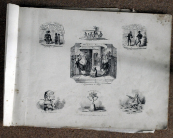
book / colection, early 19th century
George Cruikshank (27 September 1792 – 1 February 1878) was a British caricaturist and book illustrator.. His book illustrations for his friend Charles Dickens, and many other authors, reached an international audience. George Cruikshank was inventive. In the 1800's, puns and other forms of word-play were loved by all. Some of these illustrations come from his 'Scraps and Sketches' album, published for adults in 1832, though the drawings were done between 1828 and 1832. Volumes of George Cruikshank's Scraps and Sketches were intended to be cut and pasted in home-made albums and scrapbooks; George Cruikshank was a well-known British caricaturist and book illustrator. This item represents this popular art form of the early to mid 19th century.A collection of artworks (copies of etchings) of George Cruikshank. They are bound together with masking tape. The pages are dated 1828-1823. They are satirical cartoons printed in black ink.on front : "V BROOME with CANN RIVER crossed through ORBOST 78 PERRY ST 5154 2855" -
![The Fairfield Bridge [circa 1891]](/media/collectors/550653872162f11fb04854aa/items/579eab98d0cdd117c4af1c89/item-media/579eac23d0cdd117c4afb1ad/item-fit-380x285.jpg) Kew Historical Society Inc
Kew Historical Society IncPrint, The Fairfield Bridge [circa 1891], c. 1891
This work forms part of the collection assembled by the historian Dorothy Rogers, that was donated to the Kew Historical Society by her son John Rogers in 2015. The manuscripts, photographs, maps, and documents were sourced by her from both family and local collections or produced as references for her print publications. Many were directly used by Rogers in writing ‘Lovely Old Homes of Kew’ (1961) and 'A History of Kew' (1973), or the numerous articles on local history that she produced for suburban newspapers. Most of the photographs in the collection include detailed annotations in her hand. The Rogers Collection provides a comprehensive insight into the working habits of a historian in the 1960s and 1970s. Together it forms the largest privately-donated collection within the archives of the Kew Historical Society.A reproduction of a photograph of the Fairfield Bridge. The bridge was one of the first constructed for the Outer Circle Railway in 1891. Its supervising engineer was [Sir] John Monash. The bridge was later to be repurposed as a road linking the Chandler Highway to Fairfield."Outer Circle Railway Bridge over River Yarra at Fairfield (last section of line opened 1891)"fairfield bridge, chandler highway bridge, dorothy rogers, john monash, outer circle railway -
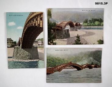 Bendigo Military Museum
Postcard - POSTCARD, JAPAN, SHUEIDO
Part of the Bennetts Collection. See Catalogue No. 9726P for details of service for "Alva Marie Bennetts".1. Colour postcard featuring a span of a wooden bridge. Stone pillar supporting span. Caption in Japanese. 2. Colour postcard featuring a view of four spans of a wooden bridge. River visible. Caption in Japanese. 3. Colour postcard featuring three spans of a wooden bridge. River in flood. Caption in Japanese.bennetts collection, alva bennetts, postcards, japan -
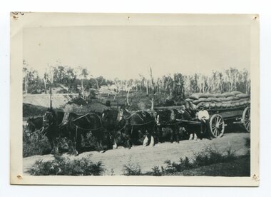
 Orbost & District Historical Society
black and white photograph
Maize,has been grown on the Orbost flats for at least 70 years. When early settlers began to arrive on the Snowy River somewhere in the 1880s, the land was mostly swamps and heavily timbered jungle on the river frontages. The swamps were drained, bit by bit, by men with short handled shovels and working in mud and water. The frontages were cleared by axe and shovel and fire. Several kinds of crops were experimented with such as hops, hemp and maize, the latter grew particularly well and became the main crop of district. The problem then was to thresh and deliver the product to the market. A small single cob machine was brought here and one man turned the handle, while the boy or Mum fed the cobs singly into the machine. A good day’s work would thresh about 50 bushels or about 12 bags (4 bushels). The task then was to cart the maize to market. For a few years this was done by horses and dray carrying about 60 bushels to Mossiface, where it was loaded onto river boats to Lakes Entrance, and then by ocean boats to Melbourne. Later it was taken to Bairnsdale by foot and loaded onto the trains to Melbourne. (more information in Newsletter October 2006)The growing of maize in the Orbost district contributed significantly to the economy of the township for many years, The many maize cribs once seen on the surrounding farms have now disappeared and this photograph is a pictorial record of that significance.A black / white photograph of a man unloading maize from a horse-drawn wagon into a maize crib. Another man is standing by the horse.maize-crib-orbost agriculture maize-corn-orbost -
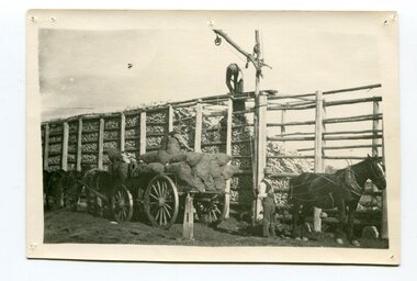
 Orbost & District Historical Society
black and white photograph, late 19th century - early 20th century
Maize, or corn as it is called in America and New South Wales, has been grown on the Orbost flats for at least 70 years. When early settlers began to arrive on the Snowy River somewhere in the 1880s, the land was mostly swamps and heavily timbered jungle on the river frontages. The swamps were drained, bit by bit, by stout hearted men with short handled shovels and working in mud and water. The frontages were cleared by axe and shovel and fire. Several kinds of crops were experimented with such as hops, hemp and maize, the latter grew particularly well and became the main crop of district. The problem then was to thresh and deliver the product to the market. A small single cob machine was brought here and one man turned the handle, while the boy or Mum fed the cobs singly into the machine. A good day’s work would thresh about 50 bushels or about 12 bags (4 bushels). The task then was to cart the maize to market. For a few years this was done by horses and dray carrying about 60 bushels to Mossiface, where it was loaded onto river boats to Lakes Entrance, and then by ocean boats to Melbourne. ( from NEWSLETTER OCTOBER, 2006) This is a pictorial record of farming practices in Orbost in the early 20th century.A black / white photograph of a horse team hauling a wagon loaded with bags of maize.A man is sitting on the edge of the wagon.farming-orbost agriculture maize corn transport -
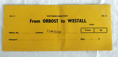 Orbost & District Historical Society
railways envelope, C 1980's
This item was used by Victorian Railways 1970's/1980's. It was used at Orbost Railway Station for the consignment of timber from Orbost to Westall.. Westall was a major timber-receiving depot near Dandenong, Victoria. Westall railway station is located on the Pakenham and Cranbourne lines in Victoria, Australia. It serves the south-eastern Melbourne suburb of Clayton South, opening on 6 February 1951. Westall station was opened as a workers only platform on 16 October 1954. It was provided for the adjacent Martin & King railway coachbuilding factory. The station was opened to the public on 1 June 1959 when all trains on the line began stopping there. The Bairnsdale-Orbost railway was opened in 1916 to serve the agricultural and timber industry. Because of the decline in traffic and heavy operating costs, the line was finally closed in August, 1987. Orbost Railway Station was opened on Monday 10 April 1916 as the terminus of the Orbost railway line, and closed in 1987. The station was located on the west side of the Snowy River despite the town of Orbost being on the east side of the river, in order to save on the costs of a bridge over the river, which at the time had highly variable levels. This item is associated with the history of the Orbost-Bairnsdale railway line and therefore reflects the role that the rail line played in the social and economic history of Orbost.An unused brown/buff coloured goods/freight consignment envelope used by Victorian Railways, this one for timber from Orbost to Westall. It is DL size.2497-78 VICTORIAN RAILWAYS G.F 63 From ORBOST to WESTALL MASS Tonnes kg Vehicle No Contents TIMBER Consignee Date orbost-bairnsdale-railway westall -
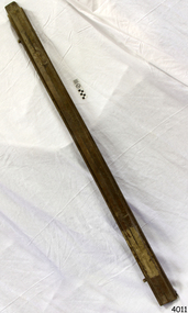 Flagstaff Hill Maritime Museum and Village
Tool - Wood Sample, Before 1878
On a piece of paper subsequently glued near one end of its curved upper face, this length of planed and polished hardwood timber bears the inscription: “A [p]iece of w[r]ec[k] of the Loch Ard wrecked near Sherbroke River”. The timber is carefully worked with rich dark colouring and a uniformly moulded design, suggesting that it was part of a fitting or furnishing that was publicly visible and prominent. If the artefact is what it is declared to be, then it is possible that it formed part of the ship’s railings or companionway stairs. The LOCH ARD was a 1,693 ton, 3 masted barque, built on the Clyde in 1873. In an age of increasing competition for the emigrant passenger trade from steam-driven vessels, special attention was paid to her wooden furnishings and fittings. The Loch Line owners prided themselves on their attractive, distinctively painted, sailing ships. Below decks, where cargo and third class passengers were stowed, was made of iron. But everything above deck, and on show to the saloon and second class passengers, was carved and varnished timber. Captain Daish’s 1878 report for the ship’s underwriters notes “a quantity of general Cargo washed up in a confused mass” in the cove and “a number of Cases, Casks and Bales; also deals and boards floating about in some of the gorges” further west of the shipwreck. Contemporary newspaper accounts also reported a large quantity of cargo and timber washed ashore in the days following the LOCH ARD shipwreck, adding “but those were speedily removed by persons who came down from Port Campbell, Scott’s Creek and other places with carts and pack horses”. The appearance and good condition of this wood artefact, and the aged patina and dated hand-writing style of its pasted on inscription, support the suggestion that it was ‘souvenired’ from the floating debris of the LOCH ARD at or near the 1878 date of its foundering off Mutton Bird Island. HISTORY OF THE LOCH ARD The LOCH ARD belonged to the famous Loch Line which sailed many ships from England to Australia. Built in Glasgow by Barclay, Curdle and Co. in 1873, the LOCH ARD was a three-masted square rigged iron sailing ship. The ship measured 262ft 7" (79.87m) in length, 38ft (11.58m) in width, 23ft (7m) in depth and had a gross tonnage of 1693 tons. The LOCH ARD's main mast measured a massive 150ft (45.7m) in height. LOCH ARD made three trips to Australia and one trip to Calcutta before its final voyage. LOCH ARD left England on March 2, 1878, under the command of Captain Gibbs, a newly married, 29 year old. She was bound for Melbourne with a crew of 37, plus 17 passengers and a load of cargo. The general cargo reflected the affluence of Melbourne at the time. On board were straw hats, umbrella, perfumes, clay pipes, pianos, clocks, confectionary, linen and candles, as well as a heavier load of railway irons, cement, lead and copper. There were items included that intended for display in the Melbourne International Exhibition in 1880. The voyage to Port Phillip was long but uneventful. At 3am on June 1, 1878, Captain Gibbs was expecting to see land and the passengers were becoming excited as they prepared to view their new homeland in the early morning. But LOCH ARD was running into a fog which greatly reduced visibility. Captain Gibbs was becoming anxious as there was no sign of land or the Cape Otway lighthouse. At 4am the fog lifted. A man aloft announced that he could see breakers. The sheer cliffs of Victoria's west coast came into view, and Captain Gibbs realised that the ship was much closer to them than expected. He ordered as much sail to be set as time would permit and then attempted to steer the vessel out to sea. On coming head on into the wind, the ship lost momentum, the sails fell limp and LOCH ARD's bow swung back. Gibbs then ordered the anchors to be released in an attempt to hold its position. The anchors sank some 50 fathoms - but did not hold. By this time LOCH ARD was among the breakers and the tall cliffs of Mutton Bird Island rose behind the ship. Just half a mile from the coast, the ship's bow was suddenly pulled around by the anchor. The captain tried to tack out to sea, but the ship struck a reef at the base of Mutton Bird Island, near Port Campbell. Waves broke over the ship and the top deck was loosened from the hull. The masts and rigging came crashing down knocking passengers and crew overboard. When a lifeboat was finally launched, it crashed into the side of LOCH ARD and capsized. Tom Pearce, who had launched the boat, managed to cling to its overturned hull and shelter beneath it. He drifted out to sea and then on the flood tide came into what is now known as LOCH ARD Gorge. He swam to shore, bruised and dazed, and found a cave in which to shelter. Some of the crew stayed below deck to shelter from the falling rigging but drowned when the ship slipped off the reef into deeper water. Eva Carmichael had raced onto deck to find out what was happening only to be confronted by towering cliffs looming above the stricken ship. In all the chaos, Captain Gibbs grabbed Eva and said, "If you are saved Eva, let my dear wife know that I died like a sailor". That was the last Eva Carmichael saw of the captain. She was swept off the ship by a huge wave. Eva saw Tom Pearce on a small rocky beach and yelled to attract his attention. He dived in and swam to the exhausted woman and dragged her to shore. He took her to the cave and broke open case of brandy which had washed up on the beach. He opened a bottle to revive the unconscious woman. A few hours later Tom scaled a cliff in search of help. He followed hoof prints and came by chance upon two men from nearby Glenample Station three and a half miles away. In a state of exhaustion, he told the men of the tragedy. Tom returned to the gorge while the two men rode back to the station to get help. By the time they reached LOCH ARD Gorge, it was cold and dark. The two shipwreck survivors were taken to Glenample Station to recover. Eva stayed at the station for six weeks before returning to Ireland, this time by steamship. In Melbourne, Tom Pearce received a hero's welcome. He was presented with the first gold medal of the Royal Humane Society of Victoria and a £1000 cheque from the Victorian Government. Concerts were performed to honour the young man's bravery and to raise money for those who lost family in the LOCH ARD disaster. Of the 54 crew members and passengers on board, only two survived: the apprentice, Tom Pearce and the young woman passenger, Eva Carmichael, who lost all of her family in the tragedy. Ten days after the LOCH ARD tragedy, salvage rights to the wreck were sold at auction for £2,120. Cargo valued at £3,000 was salvaged and placed on the beach, but most washed back into the sea when another storm developed. The wreck of LOCH ARD still lies at the base of Mutton Bird Island. Much of the cargo has now been salvaged and some was washed up into what is now known as LOCH ARD Gorge. Cargo and artefacts have also been illegally salvaged over many years before protective legislation was introduced. One of the most unlikely pieces of cargo to have survived the shipwreck was a Minton porcelain peacock - one of only nine in the world. The peacock was destined for the Melbourne International Exhibition in 1880. It had been well packed, which gave it adequate protection during the violent storm. Today, the Minton peacock can be seen at the Flagstaff Hill Maritime Museum in Warrnambool. From Australia's most dramatic shipwreck it has now become Australia's most valuable shipwreck artefact and is one of very few 'objects' on the Victorian State Heritage Register. The Loch Ard wreck is of state significance – Victorian Heritage Register S417. However there is a lack of documented provenance that limits the interpretive value of this piece of timber (for example, its potential to interpret nineteenth century souveniring and scavenging from shipwrecks along the south west coast of Victoria). Flagstaff Hill’s collection of artefacts from LOCH ARD is significant for being one of the largest collections of artefacts from this shipwreck in Victoria. It is significant for its association with the shipwreck, which is on the Victorian Heritage Register (VHR S417). The collection is significant because of the relationship between the objects, as together they have a high potential to interpret the story of the LOCH ARD. The LOCH ARD collection is archaeologically significant as the remains of a large international passenger and cargo ship. The LOCH ARD collection is historically significant for representing aspects of Victoria’s shipping history and its potential to interpret sub-theme 1.5 of Victoria’s Framework of Historical Themes (living with natural processes). The collection is also historically significant for its association with the LOCH ARD, which was one of the worst and best known shipwrecks in Victoria’s history. A length of hardwood timber, planed and varnished to smooth finish on three sides, with two unfinished tongues protruding from each end (one broken off), possibly from the wreck of the LOCH ARD. The front or upper face is moulded and routed to a regular, linear (skirting board type) design along its entire length, the two sides flat planed. One side contains two inserted dowel rods that have been broken off. The bottom face has not been finished to the same standard. The sample is good quality wood that has retained its density and weight and shows no evidence of having been submerged in seawater for any length of time. Glued on to the upper face of the length of timber near the right hand end is a deteriorated square of paper bearing an inscription. The paper, peeling back and with torn edges, is stuck over an original wood stain but under a subsequent layer of varnish. The faded ink words are indecipherable where paper is missing, but written carefully in an old fashioned cursive script.The inscription on the paper reads: “A [p]iece of w[r]ec[k] of the Loch Ard wrecked near Sherbroke River”. flagstaff hill, warrnambool, shipwrecked coast, flagstaff hill maritime museum, maritime museum, shipwreck coast, flagstaff hill maritime village, great ocean road, loch line, loch ard, captain gibbs, eva carmichael, tom pearce, glenample station, mutton bird island, loch ard gorge, nineteenth-century souveniring, shipwreck scavenging, loch line sailing ships, wood sample -
![The Punt, Echuca / [by] Nicholas Caire, circa 1876](/media/collectors/550653872162f11fb04854aa/items/57825721d0cdd1176ce1789a/item-media/57825765d0cdd1176ce19829/item-fit-380x285.jpg) Kew Historical Society Inc
Kew Historical Society IncPhotograph, Anglo-Australasian Photographic Company, The Punt, Echuca, c. 1876
Nicholas Caire was born on Guernsey in the Channel Islands in 1837. He arrived in Adelaide with his parents in about 1860. In 1867, following photographic journeys in Gippsland, he opened a studio in Adelaide. From 1870 to 1876 he lived and worked in Talbot in Central Victoria. In 1876 he purchased T. F. Chuck's studios in the Royal Arcade Melbourne. In 1885, following the introduction of dry plate photography, he began a series of landscape series, which were commercially successful. As a photographer, he travelled extensively through Victoria, photographing places few of his contemporaries had previously seen. He died in 1918. Reference: Jack Cato, 'Caire, Nicholas John (1837–1918)', Australian Dictionary of Biography.An original, rare photograph from the series 'Views of Victoria: General Series' by the photographer, Nicholas Caire (1837-1918). The series of 60 photographs that comprise the series was issued c. 1876 and reinforced a neo-Romantic view of the Australian landscape to which a growing nationalist movement would respond. Nicholas Caire was active as a photographer in Australia from 1858 until his death in 1918. His vision of the Australian bush and pioneer life had a counterpart in the works of Henry Lawson and other nationalist poets, authors and painters.Views of Victoria (General Series) No.34; ‘The Punt, Echuca’; Albumen silver photograph | Photo on card with Title and Description on reverse | Mounted 24 x 30 cm; Photo 12 x 17 cm.On Reverse: ‘The subject of this illustration is the principal crossing-place on the River Murray at Echuca, as regards the ordinary road traffic from the district of Riverina, New South Wales. After the periodical floods, the Punt is found to be insufficient for the large traffic; but this inconvenience will not be found to occur again to any great extent, as the new Railway Bridge from Moama will considerably lessen the road traffic through the Township of Echuca.’nicholas caire (1837-1918), echuca (vic), landscape photography -
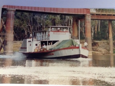 Port of Echuca
Photograph - Coloured, March 1984
This photograph was taken in February 1984 on the occasion of Cossen's visit to Echuca. P.S Pevensey with the name Philadelphia written across the wheelhouse can be seen steaming upstream under the bridge. This is significant because the P.S Pevensey played the role of the P. S Philadelphia in the movie "All The Rivers Run" which was filmed in Echuca in late 1982 and a sequel was filmed in Echuca early in 1989. Councillor Bob Snow can also be seen on the side deck. This is significant as the Cossen's visit to Echuca may have warranted this sort of attention The photograph also shows the state of the Echuca Moama bridge in the early 1980's.This photograph is significant because it shows the P.S. Pevensey showing the name P.S Philadelphia. The P.S Pevensey was used as the P.S Philadelphia in the TV Series "All The Rivers Run" based on the novel written by Nancy Cato. The TV series was filmed in Echuca in 1982. The TV series was a huge success and still draws tourists to the Port of Echuca. The fact that the P.S Pevensey was showing the Philadelphia name in 1984 is a bit of a mystery, but it has been known that she was dressed up again as the P.S Philadelphia sometimes for special occasions. The Cossen's visit to Echuca might have been such an occasion. It is also a good picture of the pylons under the Echuca Moama bridge and the actual bridge itself. The P.S Pevensey travelling upstream under the Echuca Moama bridge. There is a group of people on the lower side deck. People can also be seen in the wheelhouse and there is a man standing on the back deck as well as one standing next to the wheelhouse. The name Philadelphia can be seen written across the front of the wheelhouse. The river is low and shows the waterline at the Moama Beach. Four bridge pylons can be seen as well as the bridge itself.greenspot photography, p.s pevensey, murray river, echuca, la grue, bill, cossen's visit to echuca., all the rivers run, p. s philadelphia, echuca moama bridge, cossen family, cato, nancy