Showing 3600 items
matching white city
-
 City of Kingston
Photograph - Black and white, c.1973
A photograph showing the interior of a libraryBlack and white photograph of a library interior. A display shelf faces outward, with a table and chairs at the left hand end adjacent to a pillar. A notice advertising Storytime sits atop the display shelf. Further shelves run along the left hand wall under large windows. library, libraries -
 City of Kingston
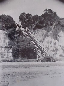
Photograph - Black and white, Percy Fairlam, c. 1910
High cliffs required access to the beachfront to be made via a steep wooden staircase.Black and white image of the steep wooden staircase at Mentone Beach, leading down to the foreshore from the clifftops above. At the base of the staircase is a bicycle leaning against a foundation post.mentone, beach, staircase, access -
 City of Kingston
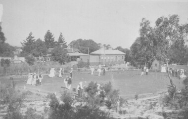
Photograph - Black and white, Percy Fairlam, c.1910
Cheltenham Bowls Club, which was located to the rear of Cheltenham Railway station. This photograph was taken by Percy Fairlam, who opened a photographers shop in Charman Road. Percy took many of the best known photographs of Cheltenham at the turn of the century.This photograph was taken by Percy Fairlam, who opened a photographers shop in Charman Road. Percy took many of the best known photographs of Cheltenham at the turn of the century.Black and white photograph of people bowling at the Cheltenham Bowling Club, depicting a large area of lawn surrounded by trees and bushes, with buildings in the background. There are several groups of men and women standing on the lawn in front of a series of small balls.Printed in black ink on a round white sticker: 111 Handwritten in red ink: 90%. Handwritten in red ink: K000603leisure, bowls, games -
 City of Kingston
Negative - 35mm, black and white, Percy Fairlam, c. 1910
Image 1a and 1b - Church of Christ, located in Chesterville Road, Cheltenham. Images 2a and 2b - Pioneer Presbyterian Church, Scots Church, located in Charman Road, Cheltenham Images 3a and 3b - Shopping strip located on Charman Road, Cheltenham, c.1918 Images 4a and 4b - A cricket team, located in Cheltenham Images 5a and 5b - Cheltenham Cricket Team, photographed outside St Matthew's Church. Back row: E. McSwain, R. Woff, S. Cullen, F. Bodley, T. Chandler, C. Warne, A. Organ, J Monk. Middle Row: C. Roberts, A. Hewett, S. Chandler, F. Chandler, A. Chandler. Front Row: A. Beulke, F. Groves Images 6a and 6b - Cheltenham Rifle Club Committee Opening Day of the new Butts. Back row: C Irwin, E. W. Proudman (Chemist), F T LePage, Centre: W Lamb Smith (Captain), E T Penny, G. Stayner, One unknown gentleman, Front: John Butler, city inspector, and E C Rippon (Manager of the Cheltenham and District Co-operative). A strip of 35mm black and white negative film of six photographs. rifle club, cricket, cheltenham cricket club, charman rd, church, cricket club, shopping strip, horse, cow, sport, team, cars -
 City of Kingston
Photograph - Black and white, 20 December 1945
Cheltenham is a suburb in the City of Kingston that was originally established as a rural market gardening community. The area is bordered by Highett, Mentone and Heatherton. The market gardens, farms and paddocks have gradually been sub-divided into housing and industrial estates. The Southland shopping centre is a major feature of the area.Cheltenham was established as a rural market gardening community. The Le Page family lived in Cheltenham since 1854 when Nicholas Le Page, a tailor from the Channel Island of Guernsey, bought two acres of land on Chesterville Road near Bernard Street to establish a market garden. Over the years the Le Pages purchased more land in the area. In 1875-76 Nicholas' son Frank and his wife Mary built 'Daphne Cottage' near the corner of Bernard and Wilson Streets. n the 1940s Frank's son, Everest Le Page, bought five more lots of land in Chesterville Road from the Tuck family. The Le Pages grazed horses, ponies and cows on this land, and grew pumpkins, carrots, parsnips, onions, potatoes and cabbages. Many buildings and locations within in Cheltenham commemorate the Le Page family's contribution to the Cheltenham community.Aerial photograph taken in 1945 of the Cheltenham district within the City of Kingston. The image includes Chesterville Road, the future site of Turner Road pool (now Waves) and Highett Reserve, (top left), Jellicoe Street, Argus Street, Bernard Street, Wilson Street, the Methodist Children Homes (now Southland), McIvor Street, Goulburn Street, Nepean Highway, Jamieson Street and Barker Street (bottom left), market gardens and paddocks. In the top centre of the image, "Daphne Cottage", the home of Frank T. Le Page is visible on the corner of Bernard and Wilson Streets. Much of the land depicted in this image was owned by the Le Page family. This image is possibly from the collection of aerial photographs commissioned by the Department of Crown Lands and Survey and taken by Adastra Airways.Black and white ink: 57250 White print: VIC-170 57250 20.12.45 Run 6 PROJ. No. 5 MELB. METROP AREA Black type 10200 FTS 30' LENS 20.12.45cheltenham, market gardens, industry, le page family -
 City of Kingston
Photograph - Black and white, 20 December 1945
This aerial photograph depicts the changing landscape of Cheltenham and Highett since WWII. Photographed in 1945, there is a mix of urban dwellings and industrial development and precedes the major transformation of Cheltenham with the development of the Southland shopping centre in the 1960s and expansion in the 1990s.A large part of Cheltenham was originally established as a rural market gardening community. The railway line and station brought urban development to the area and in the north, the Highett area was dominated by the Highett Gas Works. Cheltenham became a major destination for shopping in the 1960s with the opening of Southland.Aerial photograph taken in 1945 of Cheltenham and Highett within the City of Kingston. The image includes the Highett Reserve, (top right), the Methodist Children Homes (now Southland), Nepean Highway and Jamieson Street. Highett Gas Works is visible in the top left and the land now named William Fry Reserve at the intersection of Bay Road and Nepean Highway. A visible large parcel of land on the corner of Bay Road and Nepean Highway was developed in the 1990s as the west side addition to Southland. The densely vegetated area in the upper right sector of the image is now dense with housing. Tulip Grove, Heather Grove and Gilford Street are visible bottom left. This image is possibly from the collection of aerial photographs commissioned by the Department of Crown Lands and Survey and taken by Adastra Airways.Black ink: 57252 White lettering: VIC-10 57252 20.12.45 [lens information indecipherable] PROJ. No.5 MELB. METROP AREA Black pencil: 80highett, cheltenham, highett gas works, urbanisation -
 City of Kingston
Photograph - Black and white, 20 December 1945
This aerial photograph depicts the changing landscape of Cheltenham and Highett since WWII. Photographed in 1945, there is a mix of urban dwellings and industrial development and precedes the major transformation of Cheltenham with the development of the Southland shopping centre in the 1960s and expansion in the 1990s.A large part of Cheltenham was originally established as a rural market gardening community. The railway line and station brought urban development to the area and in the north, the Highett area was dominated by the Highett Gas Works. Cheltenham became a major destination for shopping in the 1960s with the opening of Southland.Aerial photograph taken in 1945 of Cheltenham and Highett within the City of Kingston. The image includes the Highett Reserve, (top right), the Methodist Children Homes (now Southland), Nepean Highway and Jamieson Street. Highett Gas Works is visible in the top left and the land now named William Fry Reserve at the intersection of Bay Road and Nepean Highway. A visible large parcel of land on the corner of Bay Road and Nepean Highway was developed in the 1990s as the west side addition to Southland. The densely vegetated area in the upper right sector of the image is now dense with housing. Tulip Grove, Heather Grove and Gilford Street are visible bottom left. This image is possibly from the collection of aerial photographs commissioned by the Department of Crown Lands and Survey and taken by Adastra Airways.Black type: Reverse lettering VIC-10 57252 20.12.45 [lens information indecipherable] PROJ. No.5 MELB. METROP AREA White lettering: Reverse writing 57252cheltenham, highett, highett gas works, urbanisation -
 City of Kingston
Photograph - Black and white, 5 January 1984
Cheltenham and Heatherton are suburbs in the City of Kingston that were originally established as a rural market gardening community. The market gardens, farms and paddocks have gradually been sub-divided into housing and industrial estates and associated infrastructure such as schools and shopping facilities. This aerial image covers a diverse section of the City of Kingston, taking in the suburbs of Cheltenham, Heatherton, Mentone and Parkdale. By 1984, the market gardens of the district have been replaced by housing and factories. The Nylex factory is visible and now closed. Mentone Bowl on the corner of Warrigal Road and Nepean Highway has now been replaced by high rise apartments, another feature of the changing landscape in the City of Kingston. The vacant land now occupied by the Moorabbin Airport Direct factory Outlet (DFO) is also depicted.Aerial photograph of Cheltenham, Heatherton, Mentone and Parkdale within the City of Kingston. The area depicted in the 1984 aerial view includes Centre Dandenong Road and Cheltenham East Primary School (top left), Kingston Heath Reserve (top right), intersection of Lower Dandenong Road, Warrigal Road, Balcombe Road and Nepean Highway (bottom left), Balmoral Drive/McSwain Street Parkdale (bottom right).White text: 3831-179 Lens information [indecipherable] RINGWOOD M/S 7922-3 RUN 16 [Clockface image] 5,300' ASL VIC DLS© 5-1-84cheltenham, heatherton, mentone, parkdale, market gardens, urbanisation -
City of Kingston
Photograph - Black and white, 5 January 1984
Moorabbin, Cheltenham and Highett are suburbs in the City of Kingston with a diverse mix of development and zoning. The market gardens, farms and paddocks have gradually been sub-divided into housing and industrial estates and associated infrastructure such as schools and shopping facilities. The area includes many parks, reserves and golf courses.This aerial image covers a diverse section of the City of Kingston, taking in the suburbs of Cheltenham, Moorabbin, Beaumaris and Highett. By 1984, the market gardens of the district have been replaced by housing and factories. The Gas and Fuel state-of-the-art Scientific Services Department is visible on Nepean Highway Highett. The CSIRO Highett site can also be seen. Both sites have now been demolished and have undergone remediation. The Southland site is visible and yet to be redeveloped by Westfield. This image portrays the diversity of development in the City of Kingston with a mixture of green spaces, housing and commercial and industrial features.Aerial photograph of Cheltenham, Beaumaris, Moorabbin and Highett within the City of Kingston. The area depicted in the 1984 aerial view includes Eden Street and Edward Street, Cheltenham (top left), Weatherall Road and Reserve Road, Cheltenham/Beaumaris (top right), Turner Road and Chesterville Road, Moorabbin (bottom left), Nepean Highway (left section), Graham Road and Middleton Street, Highett (bottom right). A large section of this image includes Cheltenham Park and Victoria Golf Club.White text: 3831-219 Lens information [indecipherable] RINGWOOD M/S 7922-3 RUN 15 Clockface image 5,300' ASL VIC DLS© 5-1-84cheltenham, highett, industrialisation, urbanisation, moorabbin, beaumaris -
City of Kingston
Photograph - Black and white, 17 January 1951
Moorabbin, Cheltenham and Highett are suburbs in the City of Kingston with a diverse mix of development and zoning. This 1954 image shows the market gardens, farms and paddocks of the Moorabbin and Cheltenham area. which have gradually been sub-divided into The Highett Gas Works is visible and Cheltenham Park and Victoria Golf Club.The suburbs of Cheltenham and Moorabbin were originally developed with extensive market gardens. Over time the district has been transformed with the farms and paddocks replaced by housing, factories and shopping centres. The Highett Gas Works on the Nepean Highway was a significant feature of the landscape and has now been demolished. and the site has undergone remediation.Aerial photograph of Cheltenham, Moorabbin and Highett within the City of Kingston. The area depicted in this 1951 aerial view includes Wickham Road, Highett (bottom right), Keys Road, Moorabbin (bottom left), Centre Dandenong Road Cheltenham (top left), Park Road, Cheltenham (top right), Nepean Highway (left section), Graham Road and Middleton Street, Highett (bottom right). Cheltenham Park and Victoria Golf Club are visible. Nepean Highway and the Frankston railway line run centrally through the image.White type: 1416-37 538 RUN239 LENS 5312" MELBOURNE METROPOLITAN 12150 17-1-51 ↆ M539 Black pencil: N [arrow]cheltenham, highett, highett gas works, market gardens -
City of Kingston
Photograph - Black and white, 3 March 1954
Cheltenham and Moorabbin are suburbs within the City of Kingston that were originally established as rural market gardening communities The area is bordered by Highett and Mentone. The market gardens, farms and paddocks have gradually been sub-divided into housing and industrial estates. Highett is developed with residential homes but was also the site of major facilities such as the Highett Gas Works. This aerial image covers a diverse section of the City of Kingston, taking in the suburbs of Moorabbin, Cheltenham, Highett and Mentone Residential housing development is prominent along the Frankston Railway line and the area still retains extensive market gardens and paddocks yet to be converted to a large industrial and commercial zone.Aerial photograph of Mentone, Cheltenham and Moorabbin within the City of Kingston. The area depicted in this 1954 aerial view includes Warrigal Road and Centre Dandenong Road intersection (top left); Charman Road, Patty Street, Bourke Street, Collins Street Mentone (top right); Keys Road Moorabbin (bottom left); Bay Road, Cheltenham (bottom right), Friendship Square, Cheltenham Park, Victoria Golf Club and Jack Barker Oval are visible. Nepean Highway and the Frankston railway line run centrally through the image. Highett Gasworks is also evident.White handwriting and type [indecipherable]. White image of clockface White image of compass White type 42956 Black handwriting 3/3/54 Williams [indecipherable] Black pencil: S [arrow] Black ink: 3/3/1954cheltenham, moorabbin, mentone, highett, market gardens -
City of Kingston
Photograph - Black and white, 27 February 1964
Cheltenham is a suburb in the City of Kingston that was originally established as a rural market gardening community. The area is bordered by Highett. The previous market gardens, farms and paddocks have gradually been sub-divided into housing and industrial estates. The Methodist Children's Home Methodist Homes for Children and St John of God Training Centre on the site of the future Southland shopping centre has not yet been demolished. The recently built Cheltenham High School is visible and the increased urbansation of the area is evident. Some farmland remains including the Le Page homestead.The developing urban area of Cheltenham within the City of Kingston. This image illustrates the mid-century urban sprawl of of Cheltenham and the subdivision of market gardens within the municipality and the changing demographic of the district as new houses are constructed and infrastructure established.Aerial photograph of the suburbs of Cheltenham and Highett within the City of Kingston. Highett Gas Works (top left); Bernard Street, Cheltenham (top right); Weatherall Road (bottom left): Elliott and Cobham Streets Cheltenham (bottom right).White handwritten: X Vic.1831 White type: MELBOURNE 1963 PROJECT RUN23 [underlined] 27-2-64 LENS 205 152-70 M/M 5.150 [arrow] White handwritten: X 166 cheltenham, highett, urbanisation -
City of Kingston
Photograph - Black and white, 20 December 1945
This photograph depicts a section of Cheltenham with a mix of housing and market gardens. The visible market gardens, farms and paddocks have gradually been sub-divided into housing, commercial and industrial estates. A large part of Cheltenham was originally established as a rural market gardening community. The railway line and station brought urban development to the area and the gradual subdivision of farmland and large land holdings for the development of housing. Aerial photograph dated 1945 of the Cheltenham area in the City of Kingston. Sydney Street (bottom left); Sinclair Street (top left); Weymar Street area off Wilson Street, Charles Street (botton right).White print VIC-170; 57197; RUN5; PROJ.No.5; MELB.METROP AREA Lens information [indecipherable] Small photograph: clockface Black ink: 57197cheltenham, market gardens, urbanisation -
City of Kingston
Photograph - Black and white, 20 December 1945
This aerial image covers a section of Cheltenham, with a large paddock yet to be converted to an industrial and later a commercial zone.This aerial photograph provides evidence of the changing landscape of Cheltenham and Highett since WWII. Photographed in 1945, the image features a large block of land now the site of site the major transformation of Cheltenham with the development of the Southland shopping centre in the 1960s and expansion in the 1990s.Aerial photograph of the Cheltenham area in the City of Kingston. This 1945 image is concentrated on the area between Bay Road and Garfield Lane with the distinctive bend into Jean Street. A large block of land runs between the Nepean Highway and the rail line. This is now the area occupied by the extension of Southland in the 1990s.cheltenham, southland, aerial photograph, highett -
City of Kingston
Photograph - Black and white, 20 December 1945
This aerial image covers a section of Cheltenham, with a large paddock yet to be converted to an industrial and later a commercial zone.This aerial photograph provides evidence of the changing landscape of Cheltenham and Highett since WWII. Photographed in 1945, the image features a large block of land now the site of site the major transformation of Cheltenham with the development of the Southland shopping centre in the 1960s and expansion in the 1990s.Aerial photograph of the Cheltenham area in the City of Kingston. This 1945 image is concentrated on the area between Bay Road and Garfield Lane with the distinctive bend into Jean Street. A large block of land runs between the Nepean Highway and the rail line. This is now the area occupied by the extension of Southland in the 1990s. It is a negative version of VKHC124.cheltenham, southland, market garden -
 City of Kingston
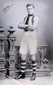
Photograph - Black and white, c.1914
This image is of Arthur Dawson, a well-known local footballer who played for the Fitzroy, St Kilda, Brighton and Moorabbin Football Clubs. As the villages of the Moorabbin area continued to grow and establish, sporting teams for both men and women were created and competitions played. Arthur Dawson went on to play for St. Kilda Football Club in the VFL in 1918, 1919 and 1921. His jumper numbers were 30 and 20. Black and white photograph of a young man wearing a striped football jersey, white shorts, striped knee-high socks and boots. He has his arms crossed and is standing in front of an ornate fence. The date 1914 is underlined in the top lefthand cornerHandwritten in red ink: 30%football, moorabbin, leisure, sport -
 City of Kingston
Photograph - Digital image, c.1918
Roderick William Mills, known as Saltbush Bill, was the inspiration for several poems by A.B. Paterson. Born at Balnarring in 1869, Mills earned the title of Saltbush Bill whilst working on a cattle station in Queensland. On these long droving trips, he learnt the art of cracking stock whips of many different lengths and sizes, a skill that earnt him £100 after a Melbourne saddler, J.K. Jennings, suggested that no man could crack a 65-foot stock whip in three tries. Saltbush Bill succeeded on his first attempt and decided to make a career in entertainment with his skill. Over his career he performed for royalty, travelled and performed extensively overseas and lent his skill to fundraising efforts, particularly during the war. His last concert was given in the Boomerang Hall in Dandenong in 1926.A local resident of the City of Moorabbin, Saltbush Bill was an ambassador for Australia and a literary inspiration to A.B. (Banjo) Paterson. Saltbush Bill, his wife Hannah Louise Porter and their 11 children lived in Old Dandenong Road, Heatherton, where Saltbush Bill and Hannah conducted a market garden for many years. Saltbush Bill is buried in Cheltenham's Pioneer Cemetery.Black and white digital imageheatherton, banjo paterson, saltbush bill, stock whip, entertainment -
 City of Kingston
Photograph - Black and white
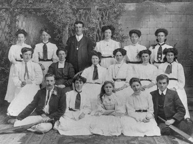
Black and white image of thirteen (13) women dressed in white blouses and skirts, in three rows. The front row of women are sitting on the floor and flanked by men dressed in suits, holding cricket bats across their knees. The middle row are seated and a woman dressed in dark clothes is seated second from left. The back row are standing and man dressed in a suit is standing, third from left. Four women have been identified in the back row (L - R): M Howard, L Ward, G Parry and R Gays.cricket, sport, women, team -
 City of Kingston
Photograph - Black and white, c.1917
Roderick William Mills, known as Saltbush Bill (left) with his sons, James Charles Mills (centre) and John James Mills (right), in London. In 1917 Saltbush Bill travelled from America to London after giving shows in various cities of the US, to spend time with his sons. James and John Mills were serving with the AIF and on leave from the French front in London. Saltbush Bill remained in London for the rest of the war as he was unable to return to Australia. Saltbush Bill, was the inspiration for several poems by A.B. Paterson. Born at Balnarring in 1869, Mills earned the title of Saltbush Bill whilst working on a cattle station in Queensland. On these long droving trips, he learnt the art of cracking stock whips of many different lengths and sizes, a skill that earnt him £100 after a Melbourne saddler, J.K. Jennings, suggested that no man could crack a 65-foot stock whip in three tries. Saltbush Bill succeeded on his first attempt and decided to make a career in entertainment with his skill. Over his career he performed for royalty, travelled and performed extensively overseas and lent his skill to fundraising efforts, particularly during the war. His last concert was given in the Boomerang Hall in Dandenong in 1926.A local resident of the City of Moorabbin, Saltbush Bill was an ambassador for Australia and a literary inspiration to A.B. (Banjo) Paterson. Saltbush Bill, his wife Hannah Louise Porter and their 11 children lived in Old Dandenong Road, Heatherton, where Saltbush Bill and Hannah conducted a market garden for many years. Saltbush Bill is buried in Cheltenham's Pioneer Cemetery.Black and white photograph of three men, one seated behind a table and two standing. The two standing are in military uniformsHandwritten in blue ink: K000733saltbush bill, stock whip, entertainment, heatherton -
 City of Kingston
Photograph - Black and white, 1962
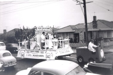
Crofts Stores (a chain of grocery stores) entered this float in the City of Moorabbin centenary procession held in 1962. Crofts had several stores in the City of MoorabbinCrofts Stores was established by Archibald Crofts with a single grocers store in South Melbourne. It eventually expanded to include 137 branches throughout Victoria, trading as Crofts Stores. Several Crofts stores existed in the City of Moorabbin and the chain pioneered self-service food stores in Australia. In 1962 the City of Moorabbin celebrated its centenary, which was marked with a procession through the streetsBlack and white photograph of a float being driven down a busy street. There are five people aboard the float, three behind a counter, and two at the rear. There are small flags reading Crofts (the business name) all around the float. Signage along the long edge of the float reads 'Crofts Stores congratulates the City of Moorabbin 1962'. Signage along the front shorter side reads 'Famous for fine foods', and signage above the counter reads 'Your grocer 1962'. There are people visible on the front porch of a house in the background, watching the float pass. Cars are parked along either side of the road and are also travelling in the opposite direction to the float.Handwritten in red ink: 60%grocery, centenary, city of moorabbin -
 City of Kingston
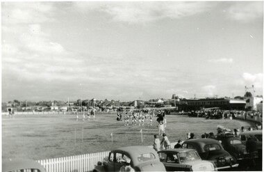
Photograph - Black and white, c.1960
This photograph shows the Linton Street oval in Moorabbin in the early 1960's before it was redeveloped to become the home ground and club headquarters of the St Kilda Football ClubThe arrival of the St Kilda Football Club to Moorabbin was a significant event in the social and commercial development of Moorabbin. The presence of a VFL football team in the community created a sense of identity and belonging for many. Black and white photograph of a sporting oval. There are people on the field and more people lining the outside edge of the field. A row of parked cars is visible across the foreground.Handwritten in red ink: 60%city of moorabbin, moorabbin, st kilda football club, linton street oval -
 City of Kingston
Pamphlet - Black and white, Robert McCamish & John Gilpin (Vendors), For Private Sale Station Entrance Estate, Highett, 1930s
Sales plan for land in the suburb of Highett, bounded by Wickham Road, Railway Parade, Highett Road and Point Nepean Street. The developing urban area of Highett within the City of Kingston. This land sale pamphlet illustrates the subdivision of land within the municipality and the changing demographic of the district as new houses are constructed. The extension of the railway line from the city to Mordialloc opened up the land for development.Black and white pamphlet advertising for private sale the Station Entrance Estate, Highett. Incorporates a map of the estate bordered by Wickham Road, Railway Parade, Highett Road and Point Nepean Road. Handwritten in black ink on reverse: Station Entrance / Estate / Late [indecipherable]highett, land sales, estate -
 City of Kingston
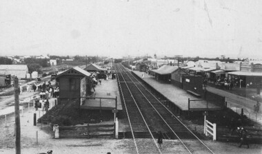
Photograph - Digital image, Black and white, c. 1910
Black and white image of Chelsea Railway Station showing the impact of the railways on the development of the area. Shops and shoppers can be seen behind the station buildings.The extension of the railway line from Mordialloc to Frankston influenced the development of the villages along the train line. Shops and community buildings were built in proximity to the station, along with the subdivision of land for houses. Black and white image of Chelsea Railway Station showing platforms and local shopschelsea, railway station, railway, shopping strip, public transport -
 City of Kingston
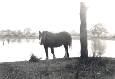
Photograph - Digital image, Black and white, c. 1950
Horse standing by a lake on the property of the Methodist Children's Homes, Cheltenham. The photograph is taken from Tennyson Street, looking towards Point Nepean Road.This image shows the land in Cheltenham, that later became Southland Shopping Centre. The land originally belonged to the Methodist Church, who operated a Children's Home on the property.Black and white image of a horse standing next to a tree trunk by a lake. cheltenham, methodist children's homes, southland, environment -
 City of Kingston
Pamphlet - Black and white, Stott & Burke, Highland Estate Bentleigh, c.1915
Sales plan for land in the suburb of Bentleigh, along Collins and Ross Streets, bounded by Jasper Road.The developing urban area of Bentleigh within the City of Kingston. This land sale pamphlet illustrates the subdivision of land within the municipality and the changing demographic of the district as new houses are constructed.Black and white pamphlet advertising for private sale the Highland Estate, Bentleigh. Incorporates a map of the estate between Collins St and Ross St, bordered by Japser Road. Handwritten in grey pencil on map: additional subdivisions numbered 15-19 drawn along Ross St Handwritten in grey pencil on map: indecipherable annotations to subdivisions 1, 3 and 14land sales, bentleigh, estate -
 City of Kingston
Pamphlet - Colour, H. R. Hill & Co, Walker's Estate, Cheltenham for sale by public auction, c. 1923
Sales plan for land in the suburb of Cheltenham, encompassing both sides of Walker Grove, a section of Centre Dandenong Rd and Axelton St. The developing urban area of Cheltenham within the City of Kingston. This land sale pamphlet illustrates the subdivision of land within the municipality and the changing demographic of the district as new houses are constructed.Black and white pamphlet advertising for private sale the Station Entrance Estate, Highett. Incorporates a map of the estate bordered by Wickham Road, Railway Parade, Highett Road and Point Nepean Road.Handwritten in black pen on subdivision map: 'x' written on subdivisions 2, 3, 8-11, 15-17, 19. Potentially indicating that these properties did not sell at auction. Handwritten in black pen on subdivision map: assumed sale price on subdivisions 1, 4-7, 12-14, 18, 20-31. land sales, cheltenham, estate -
 City of Kingston
Pamphlet - Black and white, J. F. Brady, The Hill Estate, Highett, c. 1905
Sales plan for land in the suburb of Highett, bounded by Sandford Street, Turner Street and Point Nepean RoadThe developing urban area of Highett within the City of Kingston. This land sale pamphlet illustrates the subdivision of land within the municipality and the changing demographic of the district as new houses are constructed close to infrastructure.Black and white pamphlet advertising for sale the Hill Estate, Highett. Incorporates a map of the estate bordered by Sandford Street, Turner Street and Point Nepean Road.Handwritten in grey pencil on reverse: The Hillland sales, highett, estate -
 City of Kingston
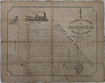
Pamphlet - Black and white, Plan of the town of Beaumaris near Brighton
-
 City of Kingston
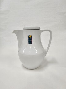
Ceramic - Moorabbin Arts Centre coffee pot, City of Moorabbin, c. 1990
Coffee pot belonging to a set produced for use at the Moorabbin Arts Centre (now Kingston Arts).White ceramic coffee pot with lid and Moorabbin Arts Centre logo on front.Marked on base: Royal Porcelain / Kingdom of Thailand / Oven to Table / Dishwasher - safe / Microwave - safeceramic, ephemera, crockery, moorabbin arts centre -
 City of Kingston
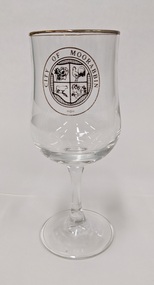
Domestic object - City of Moorabbin white wine glass, Luminarc, c. 1990
... City of Moorabbin white wine glass... Parkdale White wine glass produced for City of Moorabbin ...White wine glass produced for City of Moorabbin, incorporating gold edge and City of Moorabbin logoWhite wine glass with gold edging and City of Moorabbin logo printed in gold on front.Marked on base: France / luminarctableware, glassware, wine glass, city of moorabbin