Showing 147 items matching " back creek bridge"
-
 Bendigo Historical Society Inc.
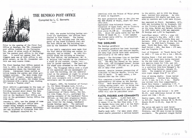
Document - LONG GULLY HISTORY GROUP COLLECTION: THE BENDIGO POST OFFICE
... ... Back Creek Bridge...Names of the pubs are: The Freemasons, The Courthouse, The Commercial Law Courts, The Hamburg, The European, The Prince Bismark, The Lord Kitchener, The Bendigo, The Rosalind Park, The Showgrounds, Atheneum Club, Olivers, Bridge Hotel, Bourkes, The Globe, The Hibernia, Albert, Albion, Abbotts, Australian, Belvidere, Beehive, British Queen, Black Eagle, British and American, Brian Boru, Bakers Arms, Butchers Arms, Brick Layers Arms, Bull and Mouth, Cresent, Clarence, Back Creek Bridge, Cape Clear, Crooked Billet, Cambridgeshire Arms, Camp, Coach and Horses, Cricketers Arms, Diggers Rest, Ellesmere, Five Lions, Franklyn, Golden Square, Golden Gate, Golden Gully, Golden Age, Golden Vine, Gumtree, Glasgow Reef, Great Britain, Haymarket, Daniel O'Connell, Half Way House, Fleece Inn, Ironbark, Johnsons Reef, Lancashire, Live and Let Live, Manchester Arms, Gold Mines, Metropolitan, Crown, National, New Chum, Honeysuckle Street, Pavilion, Napier Arms, Quartz Miners Arms, Retreat Inn, Rainbow, Rose of Australia, Lake View, Robin Hood, Fountain, Southern Cross, Bath, Berlin, Spring Gully, Star, Sir Charles Hotham, Silvermines, Royal Oak, Suburban, Town Hall, Temperance, Ship Inn, View Point, View Bend, Victoria, Exchange, American, Arcade, Belfast, All Nations, Union, United Kingdom, Union Jack, Westend, Washington, Waterloo, Wellington, Whitehorse, Wheat Sheaf, Yorkshire, Niagra and Noahs Ark....Names of the pubs are: The Freemasons, The Courthouse, The Commercial Law Courts, The Hamburg, The European, The Prince Bismark, The Lord Kitchener, The Bendigo, The Rosalind Park, The Showgrounds, Atheneum Club, Olivers, Bridge Hotel, Bourkes, The Globe, The Hibernia, Albert, Albion, Abbotts, Australian, Belvidere, Beehive, British Queen, Black Eagle, British and American, Brian Boru, Bakers Arms, Butchers Arms, Brick Layers Arms, Bull and Mouth, Cresent, Clarence, Back Creek Bridge, Cape Clear, Crooked Billet, Cambridgeshire Arms, Camp, Coach and Horses, Cricketers Arms, Diggers Rest, Ellesmere, Five Lions, Franklyn, Golden Square, Golden Gate, Golden Gully, Golden Age, Golden Vine, Gumtree, Glasgow Reef, Great Britain, Haymarket, Daniel O'Connell, Half Way House, Fleece Inn, Ironbark, Johnsons Reef, Lancashire, Live and Let Live, Manchester Arms, Gold Mines, Metropolitan, Crown, National, New Chum, Honeysuckle Street, Pavilion, Napier Arms, Quartz Miners Arms, Retreat Inn, Rainbow, Rose of Australia, Lake View, Robin Hood, Fountain, Southern Cross, Bath, Berlin, Spring Gully, Star, Sir Charles Hotham, Silvermines, Royal Oak, Suburban, Town Hall, Temperance, Ship Inn, View Point, View Bend, Victoria, Exchange, American, Arcade, Belfast, All Nations, Union, United Kingdom, Union Jack, Westend, Washington, Waterloo, Wellington, Whitehorse, Wheat Sheaf, Yorkshire, Niagra and Noahs Ark. ...Article titled The Bendigo Post Office, compiled by L C Bennetts. Mentioned is the history of the Bendigo Post Office and postmarks, some information on mining, Bendigo foundries, Underground connections of mines, expenses and shaft sinking costs. Also mentioned is Bendigo and Eaglehawk - 60 years ago and the role the pubs played in daily living. They were where theatres, concerts and dances were held, and the meeting rooms for clubs and lodges, even church benefits. Listed is a number of Bendigo hotels. Some even had a few names. Names of the pubs are: The Freemasons, The Courthouse, The Commercial Law Courts, The Hamburg, The European, The Prince Bismark, The Lord Kitchener, The Bendigo, The Rosalind Park, The Showgrounds, Atheneum Club, Olivers, Bridge Hotel, Bourkes, The Globe, The Hibernia, Albert, Albion, Abbotts, Australian, Belvidere, Beehive, British Queen, Black Eagle, British and American, Brian Boru, Bakers Arms, Butchers Arms, Brick Layers Arms, Bull and Mouth, Cresent, Clarence, Back Creek Bridge, Cape Clear, Crooked Billet, Cambridgeshire Arms, Camp, Coach and Horses, Cricketers Arms, Diggers Rest, Ellesmere, Five Lions, Franklyn, Golden Square, Golden Gate, Golden Gully, Golden Age, Golden Vine, Gumtree, Glasgow Reef, Great Britain, Haymarket, Daniel O'Connell, Half Way House, Fleece Inn, Ironbark, Johnsons Reef, Lancashire, Live and Let Live, Manchester Arms, Gold Mines, Metropolitan, Crown, National, New Chum, Honeysuckle Street, Pavilion, Napier Arms, Quartz Miners Arms, Retreat Inn, Rainbow, Rose of Australia, Lake View, Robin Hood, Fountain, Southern Cross, Bath, Berlin, Spring Gully, Star, Sir Charles Hotham, Silvermines, Royal Oak, Suburban, Town Hall, Temperance, Ship Inn, View Point, View Bend, Victoria, Exchange, American, Arcade, Belfast, All Nations, Union, United Kingdom, Union Jack, Westend, Washington, Waterloo, Wellington, Whitehorse, Wheat Sheaf, Yorkshire, Niagra and Noahs Ark.bendigo, history, long gully history group, the long gully history group - the bendigo post office, l c bennetts, mt alexander post office, porcupine inn, cenotaph, pike or pyke, baby health centre, sandhurst post office, government survey office, queen elizabeth oval, sandhurst trustees company, mr h b briston, savings bank, telegraph office, the sub-treasury, sir henry brougham lock kcb, sir john nimmo mla, prince of wales group of mines, the new prince of wales, eaglehawk golf links, new prince of wales no 2, the whip and jersey, mines department, lansell's big 180, new chum and victoria mine and battery, new chum railway, koch's pioneer, south new moon, catherine reef united, new moon, the virginia, south bell vue, central nell gwynne, north nell gwynne, miner's phthisis, hercules engine house, ironbark, new chum syncline, hercules energetic, roberts & sons, harkness & co, horwoods, great southern, ulster, carlisle, lansells big 180, victoria quartz, new st mungo, duchess tribute, south devonshire, hopewell mine, saxby mine, mcnair & co, shamrock, mr king, burke and wills expedition, sandhurst hotel, courthouse, hiberian, the freemasons, the courthouse, the commercial law courts, the hamburg, the european, the prince bismark, the lord kitchener, the bendigo, the rosalind park, the showgrounds, atheneum club, olivers, bridge hotel, bourkes, the globe, the hibernia, albert, albion, abbotts, australian, belvidere, beehive, british queen, black eagle, british and american, brian boru, bakers arms, butchers arms, brick layers arms, bull and mouth, cresent, clarence, back creek bridge, cape clear, crooked billet, cambridgeshire arms, camp, coach and horses, cricketers arms, diggers rest, ellesmere, five lions, franklyn, golden square, golden gate, golden gully, golden age, golden vine, gumtree, glasgow reef, great britain, haymarket, daniel o'connell, half way house, fleece inn, ironbark, johnsons reef, lancashire, live and let live, manchester arms, gold mines, metropolitan, crown, national, new chum, honeysuckle street, pavilion, napier arms, quartz miners arms, retreat inn, rainbow, rose of australia, lake view, robin hood, fountain, southern cross, bath, berlin, spring gully, star, sir charles hotham, silvermines, royal oak, suburban, town hall, temperance, ship inn, view point, view bend, victoria, exchange, american, arcade, belfast, all nations, union, united kingdom, union jack, westend, washington, waterloo, wellington, whitehorse, wheat sheaf, yorkshire, niagra, noahs ark -
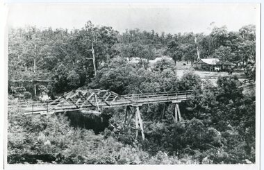 Orbost & District Historical Society
black and white photograph, c1920-1954
... on back - "Boggy Creek bridge - Nowa Nowa 1887 LaTrobe Collection"...BRIDGE AT BOGGY CREEK, NOWA NOWA, LAKE TYERS." which is a Rose Stereograph Co postcard. Boggy Creek Bridge was built in 1916 as part of the Bairnsdale to Orbost extension to the main Gippsland Railway, and is situated in the middle of the township of Nowa Nowa, crossing a steep-sided and well-timbered creek-valley. This section of the line closed in 1987. This bridge plays a major part in the identity and history of the town of Nowa Nowa, This item is associated with the East Gippsland Railway. boggy-creek-bridge East-Gippsland-Railway on back ...This is a copy of "THE BRIDGE AT BOGGY CREEK, NOWA NOWA, LAKE TYERS." which is a Rose Stereograph Co postcard. Boggy Creek Bridge was built in 1916 as part of the Bairnsdale to Orbost extension to the main Gippsland Railway, and is situated in the middle of the township of Nowa Nowa, crossing a steep-sided and well-timbered creek-valley. This section of the line closed in 1987. This bridge plays a major part in the identity and history of the town of Nowa Nowa, This item is associated with the East Gippsland Railway.A large black / white photograph of a large wooden bridge across a creek. There is a house and outbuildings in the background on the right. It is in a bush setting. on back - "Boggy Creek bridge - Nowa Nowa 1887 LaTrobe Collection"boggy-creek-bridge east-gippsland-railway -
 Bendigo Historical Society Inc.
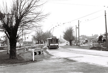
Photograph - Robert Green Collection - Photos of Bendigo Tramways - Sheet 7 of 8, 1960s
... Photos: 11147.7a No 6 to Golden Square in Mcrae Street 11147.7b No 21 to North Bendigo in Mcrae Street 11147.7c No 7 to North Bendigo in Mcrae Street 11147.7d No 7 to North Bendigo in Mcrae Street passes No 21 to Golden Square on the loop 11147.7e The Depot and Back Creek bridge 11147.7f The Depot and Back Creek bridge 11147.7g Nos 25, 23 and 30 in the depot 11147.7h The photographer in Thunder Street North Bendigo, railway line in the background 11147.7i No 21 coming up to the North Bendigo terminus in Thunder or Finn street 11147.7j No 21 leaving the North Bendigo terminus in Thunder or Finn street 11147.7k The Photographer in Thunder Street, North Bendigo 11147.7l No 21 in Thunder or Finn street 11147.7m No 21 in Thunder or Finn street 11147.7n No 17 in Eaglehawk 11147.7o No 17 in Eaglehawk 11147.7p No 26 at the top of Mitchell Street 11147.7q No 26 heading to Eaglehawk in the rain 11147.7r No 2 to Quarry Hill in the rain at the Manchester Arms Loop 11147.7s Passing Trams 11147.7t No 30 Birney Car to Quarry Hill in the rain at the Manchester Arms Loop 11147.7u No 7 to North Bendigo, the rowing Club in the background, Thunder Street 11147.7v No 7 turns into Finn Street from the North Bendigo Terminus 11147.7w The Birney Car turns into the North Bendigo Terminus from Finn Street 11147.7x The Birney Car turns into the North Bendigo Terminus from Finn Street 11147.7y Two trams at the North Bendigo Terminus 11147.7z No 24 approaches the Cemetery gates and horse hitching posts in Quarry Hill 11147.7aa The Cemetery and horse hitching posts in Quarry Hill 11147.7ab No 24 and horse hitching post in Quarry Hill...Photos: 11147.7a No 6 to Golden Square in Mcrae Street 11147.7b No 21 to North Bendigo in Mcrae Street 11147.7c No 7 to North Bendigo in Mcrae Street 11147.7d No 7 to North Bendigo in Mcrae Street passes No 21 to Golden Square on the loop 11147.7e The Depot and Back Creek bridge 11147.7f The Depot and Back Creek bridge 11147.7g Nos 25, 23 and 30 in the depot 11147.7h The photographer in Thunder Street North Bendigo, railway line in the background 11147.7i No 21 coming up to the North Bendigo terminus in Thunder or Finn street 11147.7j No 21 leaving the North Bendigo terminus in Thunder or Finn street 11147.7k The Photographer in Thunder Street, North Bendigo 11147.7l No 21 in Thunder or Finn street 11147.7m No 21 in Thunder or Finn street 11147.7n No 17 in Eaglehawk 11147.7o No 17 in Eaglehawk 11147.7p No 26 at the top of Mitchell Street 11147.7q No 26 heading to Eaglehawk in the rain 11147.7r No 2 to Quarry Hill in the rain at the Manchester Arms Loop 11147.7s Passing Trams 11147.7t No 30 Birney Car to Quarry Hill in the rain at the Manchester Arms Loop 11147.7u No 7 to North Bendigo, the rowing Club in the background, Thunder Street 11147.7v No 7 turns into Finn Street from the North Bendigo Terminus 11147.7w The Birney Car turns into the North Bendigo Terminus from Finn Street 11147.7x The Birney Car turns into the North Bendigo Terminus from Finn Street 11147.7y Two trams at the North Bendigo Terminus 11147.7z No 24 approaches the Cemetery gates and horse hitching posts in Quarry Hill 11147.7aa The Cemetery and horse hitching posts in Quarry Hill 11147.7ab No 24 and horse hitching post in Quarry Hill Photograph Robert Green Collection - Photos of Bendigo Tramways - Sheet 7 of 8 ...This collection contains eight archive sheets (Sheet 1 to Sheet 8) of strips of original 35mm black and white negatives of photographs taken by Robert green during the 1960s and early 1970s of the Bendigo State Electricty Commission of Victoria Tramways prior to their abandonment. The collection also includes two archive quality sheets (Sheet A and Sheet B) of original 35mm colour slides taken by Robert Green during the same period. Sheet B also contains one slide taken by Robert's friend Keigh S King (1928-2019) who was the author of the book 'The Bendigo Tramways an illustrated history, published by the Australian Railway Historical Society Victorian Division Melbourne in February 1972; BHS Item no. 5052. The collection also includes one USB stick which contains images of all photographs described above, except for one colour slide taken by Keith S Kings. Sixteen black and white prints from the images are also included.Robert Green Collection, this item contains 28 Black and White Negatives of the trams at various locations around Bendigo. Photos: 11147.7a No 6 to Golden Square in Mcrae Street 11147.7b No 21 to North Bendigo in Mcrae Street 11147.7c No 7 to North Bendigo in Mcrae Street 11147.7d No 7 to North Bendigo in Mcrae Street passes No 21 to Golden Square on the loop 11147.7e The Depot and Back Creek bridge 11147.7f The Depot and Back Creek bridge 11147.7g Nos 25, 23 and 30 in the depot 11147.7h The photographer in Thunder Street North Bendigo, railway line in the background 11147.7i No 21 coming up to the North Bendigo terminus in Thunder or Finn street 11147.7j No 21 leaving the North Bendigo terminus in Thunder or Finn street 11147.7k The Photographer in Thunder Street, North Bendigo 11147.7l No 21 in Thunder or Finn street 11147.7m No 21 in Thunder or Finn street 11147.7n No 17 in Eaglehawk 11147.7o No 17 in Eaglehawk 11147.7p No 26 at the top of Mitchell Street 11147.7q No 26 heading to Eaglehawk in the rain 11147.7r No 2 to Quarry Hill in the rain at the Manchester Arms Loop 11147.7s Passing Trams 11147.7t No 30 Birney Car to Quarry Hill in the rain at the Manchester Arms Loop 11147.7u No 7 to North Bendigo, the rowing Club in the background, Thunder Street 11147.7v No 7 turns into Finn Street from the North Bendigo Terminus 11147.7w The Birney Car turns into the North Bendigo Terminus from Finn Street 11147.7x The Birney Car turns into the North Bendigo Terminus from Finn Street 11147.7y Two trams at the North Bendigo Terminus 11147.7z No 24 approaches the Cemetery gates and horse hitching posts in Quarry Hill 11147.7aa The Cemetery and horse hitching posts in Quarry Hill 11147.7ab No 24 and horse hitching post in Quarry Hillkeith s king, bendigo, trams, robert green -
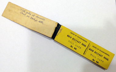 Warrnambool and District Historical Society Inc.
Certificate - Ticket Book, Main Belfast Road Toll, 2s 6d, 1860s
... Creek and on the Geelong Road at the Allansford Bridge. The toll gates were unpopular and unprofitable for the lessees as travellers were able to avoid the tax by skirting around the gates. They had toll houses besides the gates. The printers of these tickets, Fairfax and Laurie were the lessees at the time of the Warrnambool Examiner newspaper. This paper, founded by Richard Osburne and John Wilkinson, and published with some gaps from 1851 to 1880, is a key source today of Warrnambool’s history at that time. These toll gates tickets are significant because:- 1. They date back ...The Shire of Warrnambool operated toll gates from 1866 to 1869 as a means of revenue rai sing for road construction. There were three toll gate locations – on the main Belfast (Port Fairy) Road at Dennington Bridge, on the Woodford Road at Russells Creek and on the Geelong Road at the Allansford Bridge. The toll gates were unpopular and unprofitable for the lessees as travellers were able to avoid the tax by skirting around the gates. They had toll houses besides the gates. The printers of these tickets, Fairfax and Laurie were the lessees at the time of the Warrnambool Examiner newspaper. This paper, founded by Richard Osburne and John Wilkinson, and published with some gaps from 1851 to 1880, is a key source today of Warrnambool’s history at that time. These toll gates tickets are significant because:- 1. They date back to the 1860s and were only issued from 1866 to 1869. 2. They are the only artefacts we hold of the time when toll gates were operating in our local district 3. They are the best example of how the Shire of Warrnambool in its early history raised revenue for road building and maintenance This is a book of toll gate tickets for sale at the Main Belfast (Port Fairy) Road Toll Gate. The tickets (about 50) are yellow and in duplicate with provision to detach the outer ticket for the purchaser to keep. The tickets (two shillings and sixpence) are bound with an adhesive tape and the cover is mottled in pattern (brown and blue). There are also four loose tickets in blue (3 shillings). Back Cover: ‘136’ Tickets in book: ‘Shire of Warrnambool, Main Belfast Road, Toll Gate 2s 6d., Fairfax and Laurie, Printers’ Loose tickets: ‘Shire of Warrnambool, Main Belfast Road, Toll Gate, 3s.’ shire of warrnambool, toll gates -
 Kiewa Valley Historical Society
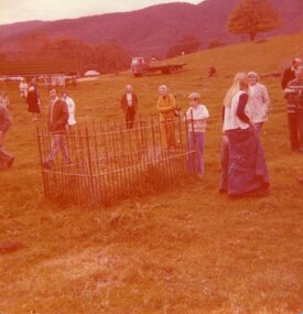
Photograph of pioneer grave, 29th May, 1977
... Bridge. Miss Hobbs, formerly of Running Creek, mentioned that twin babies of the Brigg's family are buried at Mary Holland's feet. Pictorial record of pioneer gravesites in the Kiewa Valley. Social history of people in 1977 showing interested in local history kiewa valley mullagong station tawonga hollonds family brigg's family Handwritten in faint blue ink on back of photograph: Mrs Mary Holland's grave. ...Pictorial record of the grave of pioneer woman Mrs Mary Hollonds, who passed away in 1862. The grave is located at Mullagong Station (farm) in Tawonga, five miles south of Keegan's Bridge. Miss Hobbs, formerly of Running Creek, mentioned that twin babies of the Brigg's family are buried at Mary Holland's feet.Pictorial record of pioneer gravesites in the Kiewa Valley. Social history of people in 1977 showing interested in local historyColour photograph of group visiting the grave of pioneer woman Mrs Mary Hollands at Mullagong on 29th May, 1977Handwritten in faint blue ink on back of photograph: Mrs Mary Holland's grave. Died 1862 Mullagong. 29th May, 1977kiewa valley, mullagong station, tawonga, hollonds family, brigg's family -
 Kiewa Valley Historical Society
3 X photographs of early residents of the Kiewa Valley, 1. 1949-1950
... back of photograph in ink J H Thompson, A fond memory for Mrs. Fisher, Everil & Paddy. Former pupil of Mongan’s Bridge school 3. Handwritten on back of photograph in blue ink – W M Sloan. He and his father built the water wheel 1880’s on Junction Creek...back of photograph in ink J H Thompson, A fond memory for Mrs. Fisher, Everil & Paddy. Former pupil of Mongan’s Bridge school 3. Handwritten on back of photograph in blue ink – W M Sloan. He and his father built the water wheel 1880’s on Junction Creek ...The 3 photographs are of early residents of the Kiewa Valley who have pursued varying careers. Pictorial history of early residents of the Kiewa Valley giving an insight into the accomplishments of some local residents ie: R Nicholls and T Hotter travelled from New Zealand to work in the Kiewa Valley. J.H. Thompson pursued a career as a police officer. W.M. Sloan and his father built the water wheel at Junction Creek.1. Black and white photograph of Rod Nicholls and Tom Hotter, both of Mt Egmont New Zealand 2. Black and white photograph of J.H Thompson Former pupil of Mongan’s Bridge School 3. Black and white photograph of W M Sloan taken in 1880’s. Photograph is an oval within a larger rectangle 1. Handwritten in black pen on back of photo – Rod Nicholls (wearing hat) & Tom Hotter Both of Hawera (Mt Egmont) New Zealand 1949 – 1950 2. Handwritten on the back of photograph in ink J H Thompson, A fond memory for Mrs. Fisher, Everil & Paddy. Former pupil of Mongan’s Bridge school 3. Handwritten on back of photograph in blue ink – W M Sloan. He and his father built the water wheel 1880’s on Junction Creek (Bakers) j h thompson, fisher family, mongan's bridge, w m sloan, kiewa valley -
 Kiewa Valley Historical Society
Photograph - 30 black and white photographs (assorted sizes) plus page from a newspaper and copied article on A4 paper, c1880's c1910 - 1920 (photographs) Newspaper 1961
... Bridge looking up stream". K4 - no inscription. K5: handwritten in ink, back of photo "Running Creek Cricket Team". ...Bridge looking up stream". K4 - no inscription. K5: handwritten in ink, back of photo "Running Creek Cricket Team". ...K2,3 and4 are of the Kiewa River and two of the bridges spanning the river along the valley. K3 and K4 would have been taken in the 1880's and show the type of trees and plant growth along the river prior to land clearing for farming. K5 is of the Running Creek Cricket Team and therefore there was sufficient population in the area to form and maintain a team as well as have other teams in the relatively near vicinity to provide competition. Note the horse drawn cart which provided transport. Date taken is unknown but possibly c 1910. The Mt. Buffalo Chalet was built in 1910 by the Victorian Government. It was Australia's first ski resort and has served generations of skiiers, hikers and families over the years. It was built for 3195 pounds and has had stories and wings added since and is the largest timber building in Australia. B4 is the earliest photo in this group as the garden is in early stages of development - the other photos show the growth of the shrubs and would be taken about c 1920. Note the cars and motor bikes. It closed in 2006. The other photos are of general interest only but interesting to see that there were donkey's grazing. There is no information as to their purpose on Mt. Buffalo. Four different Kiewa Valley families are represented in the photographs. Their descendants still live in the Valley and carry on the traditions of beef and dairy farming. Of particular interest is the photo of Miss Marjorie Clemence, the first School Teacher of Upper Gundowring School. Gundowring pastoral run was taken up in 1838 and occupied by framers in the 1860's. The area was known as Gundowring and Upper Gundowring. The Gundowring School was opened in 1871 and most likely the Upper Gundowring school would be built at the same time. It was School No. 2733 and situated in Boyd Road. It closed in 1953 when the Kiewa Consolidated School opened. The newspaper page describes the activities in which the local community of Kergunyah were in engaged in that period - Red Cross, Fire Brigade, cattle round up and some of the identities involved. The article photocopied from the Yackandandah times states that he (Norman Coad) "was sent to the Ovens District Hospital, Beechworth for treatment" which would mean that this was the closest hospital to the Kiewa Valley for emergencies in 1912.The Kiewa Valley photographs are of social significance showing two of the early bridges allowing the community easy access to both sides of the river and also the tree and plant growth before land clearing for farming. The photos of Mt. Buffalo Chalet have social, architectural and historical significance. the Chalet has been used by skiers, bush walkers and day trippers since its completion in 1910 and its closure in 2006. It is listed in the Victorian Heritage Register. The family photographs are of social and historical significance as they are of early farming families in the Kiewa Valley and also depict the dress, of both men and women) in the late 1880's. The write up in the Weekly Times has social significance as it depicts the social and farming activities and photos of the local residents from around that area. The article from the Yackandandah Times is of a personal nature with concern for the individual involved. Note: There is a photo of the gentleman mentioned in the article (Mr. Norman Coad) in the Families of the Kiewa Valley (F4) as above.30 black and white photographs - 5 of the Kiewa Valley, 8 of families of the Kiewa Vallley and 17 of Mt. Buffalo. Various sized photos. Page from the Weekly times and copied article from the Yackandandah Times on A4 sheet.(Note for easier identification they have been numbered and grouped - K1-5 (Kiewa Valley), F1-8 (Families) and B1-17 (Mt. Buffalo). K1: handwritten in ink, lower L hand corner "Bogong in the distance". K2: handwritten in ink lower L hand corner "Mongan's Bridge or Towonga". K3 handwritten in ink "Taken from Mongan Bridge looking up stream". K4 - no inscription. K5: handwritten in ink, back of photo "Running Creek Cricket Team". F1: handwritten in ink on back "Mrs. Heap" and lower down in pencil "1880's". F2 handwritten in pencil at top of back phot "Land at Tawonga TROVE The Y'dah Times 20/2/1913" and lower down in ink "Henry Ellis Larkin". F3: handwritten in ink bottom edge "Mrs Coad". Note that this photo is a postcard. F4: Written in ink lower edge "Norman Coad". Note this photo is also a postcard. F5: Lower left corner in Ink "Harry Larkin". F6: lower half back of photo, in ink "Bernie Maddison". F7: on back of photograph in ink "Miss Marjorie Clemence first School Teacher Upper Gundowring: and underneath, in pencil "C1880's". F8: Handwritten in ink on back of photo "Frank & Mrs. Keat & Lesley of Tawonga". Lower down in pencil "c1912-1914". B1: Back of photo in ink "The Chalet Mt. Buffalo". B2: no inscription. B3: "chalet at Bufflo" in ink lower left corner. B4: This is a post card. Written in ink is "Mt. Buffalo Chalet". B5 - B10 printed in ink, lower left corner "Buffalo". B11: no inscription. B12: "Mt. Buffalo" lower R corner. B13: "Buffalo?". B15: Printed in ink lower edge "Picnic at Buffalo". B16: "Donkeys on Mt. Buffalo" printed in ink lower edge. B17: handwritten in ink across back of photo "Donkeys & top of Mt. Buffalo with the Monileith in the distance". A4 sheet of paper describing an accident to Mr. Norman Coad. Under article is : Yackandandah Times (Vic: 1890 - 1931), Thursday 18 July 1912, page 3. A page torn from the Weekly Times, June 14, 1961 and entitled "Kergunyah has picturesque setting". kiewa valley, farming, families, kergunyah, gundowring upper, mt. buffalo chalet, briggs family, larki family, coad family, clemence family, laskowski collection -
 Kiewa Valley Historical Society
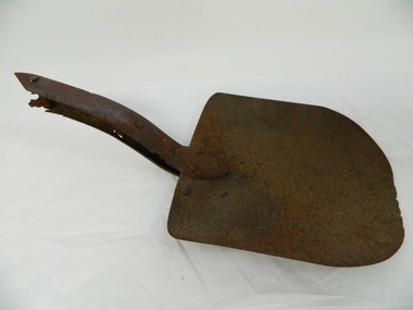
Shovel head - Fainter Falls
... bridge over a creek crossing, car parking and interpretative signage. The shovel was found during work on the Fainter Falls track. It was left there some time ago by a previous visitor to the Falls indicating that the Falls were accessible and attracted visitors many years ago. shovel. fainters falls. bogong. walking track. fire track. water. Rusty metal shovel head curved on each side and rounded at the front. At the back ...The Fainter Falls Walking Track was originally accessible via a fire fighting access trail, which was used by fire-fighters putting out spot fires caused by lightening strikes. The fires in the summer of 2003, highlighted the beauty of this area and provided the residents with the opportunity to consider the redevelopment of the trail. Work to establish a 700 metre grade 2 walking trail with a 50 metre grade 3 extension trail to the Falls began in 2005. It also includes 3 observation decks, a bridge over a creek crossing, car parking and interpretative signage.The shovel was found during work on the Fainter Falls track. It was left there some time ago by a previous visitor to the Falls indicating that the Falls were accessible and attracted visitors many years ago.Rusty metal shovel head curved on each side and rounded at the front. At the back of the blade it is attached on top with 3 nails to the top piece. The top metal piece overlaps the blade by 6.5 cm longitudinally x 5 cm across. On the back the metal piece overlaps the blade by 12 cm both longitudinally and across the handle end but tapers to a point. It has 6 nails attaching it. Both metal pieces are attached to the blade and curve parallel and around so that a wooden handle would fit between them. This would have 2 nails passing through both metal pieces and the handle. (The handle is missing.) shovel. fainters falls. bogong. walking track. fire track. water. -
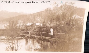 Kiewa Valley Historical Society
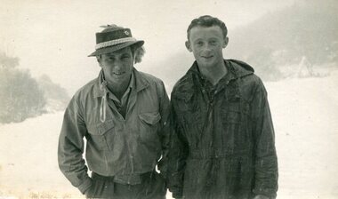
Black and white photograph of Surveyor's Camp, 1938, Kiewa River and surveyor's Camp 25/8/38, 25/08/1938
... bridge across the West Kiewa river. It has been taken from approx. 100m up Simmonds Creek Road. surveyor tawonga west kiewa river bridge camp SECV At the top of the photograph, handwritten in black ink is the inscription "Kiewa River and Surveyor's Camp 25/8/38". The number 4 is stamped towards the right upper corner. On the back ...Surveying under the prevailing conditions at this time was an arduous and demanding task. There were no roads beyond Tawonga and access was by bridle tracks, on foot or horseback. This camp was to provide accommodation to those men who were surveying the road from South Tawonga to the Bogong High Plains which was commenced in April, 1938. The actual work was undertaken by the Country Roads Board, on behalf of the State Electricity Commission, using three Caterpillar diesel crawler tractors equipped with Kay Bruneriei (Brunner) lhydraulically operated trailbuilders (angle dozers)This photograph shows the primitive living conditions that were endured by those carrying out the initial field investigations and surveys for the Kiewa Hydro Electric Scheme. It is possibly one of the few photographs in existence of this camp and of the very rustic timber foot bridge across the West Kiewa river. It has been taken from approx. 100m up Simmonds Creek Road. A black and white photograph showing a small, timber foot bridge across the West Kiewa River. There is a man standing on the bridge and two small huts on the far side of the river, against a backdrop of Mt. Beauty and Mt. Bogong.At the top of the photograph, handwritten in black ink is the inscription "Kiewa River and Surveyor's Camp 25/8/38". The number 4 is stamped towards the right upper corner. On the back, in a circle, about 1.3cm in diameter, are the words "Kodak Print". The word "Velox" is faintly discernible on the back as well.surveyor, tawonga, west kiewa river, bridge, camp, secv -
 Orbost & District Historical Society
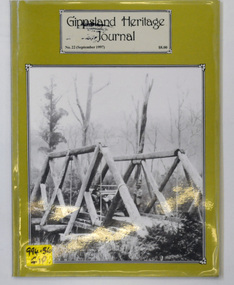
journal, Gippsland Heritage Journal, September 1997
... back cover is a library barcode. On the front is a call no. 994.56 GIP A 64 pp magazine, titled Gippsland Heritage Journal. The cover is olive green with a b/w photograph of the Snowy Creek bridge at Mitta Mitta in 1914. ...This issue was edited by Meredith Fletcher.This item is a useful reference on the history of Gippsland.A 64 pp magazine, titled Gippsland Heritage Journal. The cover is olive green with a b/w photograph of the Snowy Creek bridge at Mitta Mitta in 1914. The magazine is dated September 1997 and is covered in plastic. It contains photographs and articles on the history of Gippsland.On the outside back cover is a library barcode. On the front is a call no. 994.56 GIPgippsland-heritage-journal history-gippsland -
 Eltham District Historical Society Inc
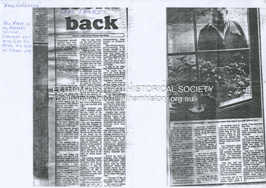
Document - Photocopy, Diamond Valley News, Newspaper article: Fred looks back by Linley Hartley, Diamond Valley News, c.1985
... Creek bridge. He was hospitalised in the little hospital on the east side of Eltham village that served the district in those days. He still carries the scars of the burns he received from the exhaust pipe and recent x-rays have revealed several broken vertebrae. At the time of the accident he was treated for a dislocated neck and was in plaster from his hip to the base of his head for about seven months. But nothing daunted Fred. Bouncing back...Creek bridge. He was hospitalised in the little hospital on the east side of Eltham village that served the district in those days. He still carries the scars of the burns he received from the exhaust pipe and recent x-rays have revealed several broken vertebrae. At the time of the accident he was treated for a dislocated neck and was in plaster from his hip to the base of his head for about seven months. But nothing daunted Fred. Bouncing back ...Fred looks back; Report: Linley Hartley, Picture: Ron Grant Teaching himself German again after 70 years is just one of the many tasks Fred Golgerth, of Greensborough, has undertaken and succeeded in during his lifetime. As the two year old tenth child of a German descendent, Fred learnt to speak German from an Aunt. But World War 1 was raging. Fred’s older brother had gone to Europe with the Australian forces, changing his name … to ….. to sound less German. “I used to get my bottom slapped for speaking German at home,” Fred said. Even his name was changed from Otto to the more anglicised Frederick. Fred claims his involvement with Eltham started two years before he was born! His sister, two years older than him, was a babe in arms when his parents bought a piece of grazing property in Mount Pleasant Rd. “It was about 24 acres on a spur of Mt Pleasant,” Fred said. “My parents bought it from Mr and Mrs Hughes. There was a two-room mud hut in wattle and daub that we lived in from time to time. “My parents had a dairy farm and dairy in West Coburg, and they bought the Mt Pleasant land to put the dry stock on. “At one stage my mother got very ill and my older sister took my younger sister and myself to Eltham for four or five months. I went down to Eltham Primary School then.” That wasn’t the only time Fred stayed in Eltham. His sister, Wilhemina, known as Willa, married Jim Watson who had the Eltham hotel for some years from the end of World War 1. Pillar to post living was the way Fred described his youth, when he stayed with one married sister after another. “After a while Will and Jim lived in the big house at the top of Pitt St, next to the Council depot, and the hotel was managed by Fitzsimmons who had a big place near the river down there on Fitzsimons Lane. There was no bridge in Fitzsimons Lane but we used to cross the river at a ford, rolling up our trouser legs so they wouldn’t get wet, and carrying our shoes. I’d o down to visit some friends I had in Templestowe. And sometimes Jim Watson took his horse drawn lorry across the ford on his way to the brewery, instead of going don through Heidelberg.” “The bridge across the Yarra in Fitzsimons was not built until 1961.” Fred Golgerth, was only a teenager when he was rolled off his pushbike under a car on the bend between Mt Pleasant Rd and the Diamond Creek bridge. He was hospitalised in the little hospital on the east side of Eltham village that served the district in those days. He still carries the scars of the burns he received from the exhaust pipe and recent x-rays have revealed several broken vertebrae. At the time of the accident he was treated for a dislocated neck and was in plaster from his hip to the base of his head for about seven months. But nothing daunted Fred. Bouncing back he began work as an apprentice to a motor mechanic in Bell St, Preston, a man who is still living (at 90) in Queensland and who still communicates with Fred frequently. “He was like a father to me,” Fred declared. He was a marine engineer as well, so I …. that as well as blacksmithing. They taught us properly then.” After finishing his apprenticeship, Fred bought himself a 30 hundredweight Fargo truck and began his own contract carting business, doing most of the work for a firm called Carnegie’s and a subsidiary of that, Howard Radio. It was in the office Fred met his wife. “He taught me to drive the truck giving me lessons in my lunch hours up the Bourke St and Flinders St extension,” she said. “After work I’d have a driving lesson and all the girls from the Howard Radio would pile in the back to get a lift to Richmond Station.” In the 1939 bushfires, the Mt Pleasant Rd property was burnt out and the hut raised. Two years later, Fred and Dorothy were married. Fred paid £7.15.0 ($15.50) for the suit in which he was married. Dorothy had pulled out of the Women’s Air Training Corps to be married. Others with whom she trained went to Darwin and were in a convoy that was bombed. Fred went into the garage business in Brighton and continued his cartage business for a while. His company was employed to do all Brown Gouge’s motor repairs and factory maintenance. Because Fred had a certificate to do steam repair work he often got jobs maintaining industrial boilers. While he was in Brighton, Fred bought an eight-seater 1925 Silver Ghost Rolls Royce from Sir Keith Murdoch. When the couple moved to Rosanna in about 1943, it became a delivery van for the dairy they operated. “I thought I’d like to get back into a dairy business” Fred said. “We used to deliver the milk in the Rolls. “But it was hard work. We couldn’t get the labour and we’d drive to the farm and pick up the milk cans, take them back to the dairy, cool the milk, bottle it and deliver it. The inspectors would come regularly and the walls for bacteria.” Fred was exhausted. The couple gave up the dairy and moved to Eltham to live on the old property where a weatherboard house had now been built. It wasn’t a big house and the glassed in Rolls Royce limousine became the daytime nursery for the Golgerth’s second daughter. We’d put her in there to sleep during the day.” “Dorothy Golgerth was known to drive the Rolls at breakneck speed along Mt Pleasant Rd. Fred took some time off work then began driving a little local bus run by the Lyon Brothers before taking a maintenance job at the Athenaeum Club in the city. He’d ride an old Harley-Davidson to the station and travel into the city by train. Later, when the family moved to Pryor St. (their house stood where McEwans car park is now) Fred could walk to and from the station. “There was no resident doctor in the early days of Eltham,” Fred said. “Dr Cordner used to come from Greensborough to a room in the old house next to the old grocery shop on the corner of York St and Main Rd, Eltham (the grocery shop is now the Eltham Feed and Grain Store). The Golgerths lived in Eltham until “Dollar Day” – the day decimal currency became official. They eventually moved to Greensborough, when they have lived since. Fred has had his share of interesting jobs since then, retiring at 65 seven years ago when he was working in the engineering department at Larundel. Recently, two of his older sisters and a brother died, within a month. They were all in their 80s. They all had a profound influence on Fred, especially during his youth. His sharp wit and amusing anecdotes are the richer for his having been the youngest of a family that made the best of every circumstance. And now, as he enjoys his retirement, he is concentrating on relearning the language of his infancy; teaching himself German from tapes and a ‘teach yourself’ manual. He is fiercely proud of his German ancestry and treasures the diary, written in German in Gothic script, kept by his grandparents during their journey to Australia. On the inside in blue pen: "To Sadie, Wal Margaret & Elizabeth with lots & lots of love & best wishes from Mother"marg ball collection, eltham hotel, herbert james watson, otto (fred) golgerth, wilhemina watson (nee golgerth) -
 Eltham District Historical Society Inc
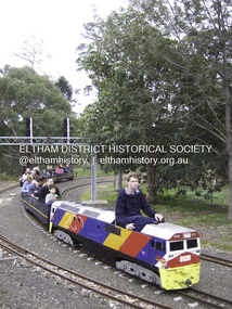
Photograph - Digital Photograph, Marguerite Marshall, Diamond Valley Railway, Eltham Lower Park, 7 September 2008
... back with his whistle and green flag at the ready. The winding track, fringed by native trees and bushes planted by volunteers, stands on crown land managed by Nillumbik Council. The train clatters along the track and crosses a bridge over a drain elevated by name to The Blow Fly Creek. ...back with his whistle and green flag at the ready. The winding track, fringed by native trees and bushes planted by volunteers, stands on crown land managed by Nillumbik Council. The train clatters along the track and crosses a bridge over a drain elevated by name to The Blow Fly Creek. ...Kids of all ages enjoy the Miniature Railway. Published: Nillumbik Now and Then / Marguerite Marshall 2008; photographs Alan King with Marguerite Marshall.; p163 On Sundays in Eltham thousands of children, mums, dads and grandparents can be seen travelling around Lower Eltham Park in tiny trains. They are among the two and half million passengers who have travelled on the Diamond Valley Railway since it officially began in 1961. The miniature railway originally operated from the 1940s at Chelsworth Park, Ivanhoe, until flooding caused it to be moved to the Eltham Lower Park in 1959. The railway is modelled on the 1920s era – the heyday of passenger rail travel – and the trains are built on a scale of two inches to the foot (1/6). Although not exact replicas, trains include models of the Spirit of Progress, Puffing Billy, The Overland, Dog Boxes, Vic Rail S class, G class and a NSW 81 Class. The three and a half kilometres of track is set amongst native plants and picnic areas. A friendly hoot or the clang of a bell occasionally punctuates the tranquillity as a train emerges from a treed bend with passengers excitedly waving to onlookers. For $3 the train takes you on a 13-minute two-kilometre ride. Passengers sit in single file in the narrow train, which clatters along tracks built to the scale of the Australian narrow gauge of three feet six inches (1.1m). These are used in Queensland, South Australia, Tasmania and Western Australia. Safety standards are stringently kept. Even before you buy a ticket notices tell you that you must wear closed shoes. You can even borrow these, and you are given a pair of socks for the ride! Blue-overalled volunteers check tickets, see you aboard, and drive the train. They are mainly retired men who can at last devote their time to what little boys dream of – playing with trains. Passengers are instructed in safe behaviour, then the station master waves a white flag and off we go. The guard sits at the back with his whistle and green flag at the ready. The winding track, fringed by native trees and bushes planted by volunteers, stands on crown land managed by Nillumbik Council. The train clatters along the track and crosses a bridge over a drain elevated by name to The Blow Fly Creek. We pass by Meadmore Junction at a speed of three kilometres an hour. Then on through a tunnel, accompanied by squeals of delight, and after a few moments of blackness, light glimmers at the end. On we go, past the original platform, along another route past busy Main Road through Pine Creek Station, over a bridge and through another tunnel with more screams of delight.Then a signal stops us before the ‘all clear’ to return to our original point of departure. The railway services its passengers – the largest number of any miniature railway in Australia – with a fleet including: six diesel locomotives, three steam locomotives, eight sets of passenger cars and one battery electric Dog Box set. Members also privately own 20 locomotives and powered carriage sets as well as four carriage sets.1 All the trains are stored on-site in workshops, sheds and a tunnel. The railway is entirely run by volunteers, so that all ticket money is used for maintenance and extensions, and some goes to local charities. Since 1991, the entire railway has been rebuilt, including an upgraded signalling system. About half of the 120 volunteer members are active with about 35 working each Sunday, and a dozen or so working every Wednesday. Members are trained to positions of station assistant, booking officer, train guard, train driver or signalman. Members construct new carriages and locomotives as well as maintaining track, signalling and rolling stock.This collection of almost 130 photos about places and people within the Shire of Nillumbik, an urban and rural municipality in Melbourne's north, contributes to an understanding of the history of the Shire. Published in 2008 immediately prior to the Black Saturday bushfires of February 7, 2009, it documents sites that were impacted, and in some cases destroyed by the fires. It includes photographs taken especially for the publication, creating a unique time capsule representing the Shire in the early 21st century. It remains the most recent comprehenesive publication devoted to the Shire's history connecting local residents to the past. nillumbik now and then (marshall-king) collection, diamond valley railway, eltham lower park -
 Eltham District Historical Society Inc
Photograph, Upper Yarra Dam, Spring Tour, 22 Oct 1995, 22/10/1995
... creek named after him), about the 'Eddies'?, and the disliked 'meccano' bridge in Warburton, etc. etc. The hot roast lunch in the old Reefton Hotel was also most welcome. It was easy to imagine it peopled by miners and early settlers. Starting by crossing the new (1974) concrete bridge at Warrandyte we headed through Wonga Park with views to the Christmas Hills and to the escarpment of the Yering Gorge, which causes flood waters to back up through the Yarra Glen plain, so avoiding disasters downstream. ...creek named after him), about the 'Eddies'?, and the disliked 'meccano' bridge in Warburton, etc. etc. The hot roast lunch in the old Reefton Hotel was also most welcome. It was easy to imagine it peopled by miners and early settlers. Starting by crossing the new (1974) concrete bridge at Warrandyte we headed through Wonga Park with views to the Christmas Hills and to the escarpment of the Yering Gorge, which causes flood waters to back up through the Yarra Glen plain, so avoiding disasters downstream. ...EXPLORING THE UPPER YARRA (Newsletter No. 105, November 1995, by Bettina Woodburn) We enjoyed the Spring Excursion, this year "Exploring the Upper Yarra" - in spite of the constant rain and the countryside under the cloud cover, especially in the valleys, being mainly shiny shades of green. The occasional fields of buttercups, clumps of arum lilies and splendid rhododendron and other flowering bushes became very special. The Cobb and Co coach was warm and a cosy retreat as we zig-zagged on the highways and byways to glimpse the Yarra River, upstream and down, its secret places, and particularly the many bridges. Russell excelled as 'Poet Laureate', reading from Dacre Smyth's book. This 1979 publication includes paintings of all the bridges along the river with poems and brief descriptions of each one. Some of the bridges are in out of the way places and are not very well known. We looked forward to hearing the poetry as much as seeing the ' constructions'…Big Pat (was he short or tall, lean or fat? He did win the two hundred pound reward for discovering gold and had the creek named after him), about the 'Eddies'?, and the disliked 'meccano' bridge in Warburton, etc. etc. The hot roast lunch in the old Reefton Hotel was also most welcome. It was easy to imagine it peopled by miners and early settlers. Starting by crossing the new (1974) concrete bridge at Warrandyte we headed through Wonga Park with views to the Christmas Hills and to the escarpment of the Yering Gorge, which causes flood waters to back up through the Yarra Glen plain, so avoiding disasters downstream. At the end of a long driveway we found the wooden, privately owned Henley Bridge (1935 after the 1934 floods). This facilitates access to different parts of Henley Farm and to Lilydale. Everard Park, named after Blanche Shallard's father, a State Member for 17 years, below the Highway Yarra crossing was in need of care. It is 10 miles from Yarra Glen by road but, as "Yarra Marra” canoeists well know, 32 winding miles down by water. After more delightful countryside scenes we joined the Warburton Highway at Woori Yallock. From the old Railway Station at Launching Place the Centennial Trail for walkers, cyclists and ' horse riders has replaced the rails. The line from Lilydale was opened in 1901, and the last diesel freight train ran to Warburton in 1965. It continued to rain as we had morning tea in Warburton in a shelter between footbridges. From here we continued upstream past the Bridge to O'Shannasy Lodge and Reservoir, Starvation Creek, and the Peninsular tunnel (miners dug it as at Pound Bend) which we visited (scrambling down those steps!) on our return after lunch. Our furthermost point was the Upper Yarra Dam Reserve (and vast catchment area). Finished in 1957 after ten years work and 100 years after Yan Yean, it supplies much of Melbourne's water. After crossing the 30m Launching Place Bridge to the Eltham side of the Yarra and Healesville, we saw in the distance the Yarra Glen Timber Trestle Bridge over the river flats "the longest for years in the land it was said!" Harry's dream of "better weather over the Divide" unfortunately didn't come true, but I'm sure we 36 members will retain happy memories of a day that was wet and green and filled with Bridges. Bettina Woodburn - October 1995 Record of the Society's history of activities - Spring 1995 excursionColour photographshire of eltham historical society, activities, upper yarra dam, henley bridge -
 Eltham District Historical Society Inc
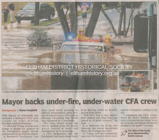
Newsclipping, Shaun Campbell, Mayor backs under-fire, under-water CFA crew, Diamond Valley Leader, December 2011
... bridge opposite the reserve then flooding the Judge Book Village before finally entering the Diamond Creek. Widespread damage occured from hail and flash flooding. Fay Bridge Collection Eltham Flood damage floods Floodwater Main Road Research Fire Brigade Digital file - scanned from newsclipping on loan Mayor backs under-fire, under-water CFA crew, Diamond Valley Leader Newsclipping Shaun Campbell Diamond Valley Leader ...A late afternoon storm on Christmas Day 2011. A flash flood occurred from significant rain fall and hail, which accumulated along an old waterway with floodwater submerging cars along Valonia Drive then down Grove Street flooding houses, through the Bible Street Reserve where it then submerged Main Road washing away the small railway trestle bridge opposite the reserve then flooding the Judge Book Village before finally entering the Diamond Creek. Widespread damage occured from hail and flash flooding.fay bridge collection, eltham, flood damage, floods, floodwater, main road, research fire brigade -
 Eltham District Historical Society Inc
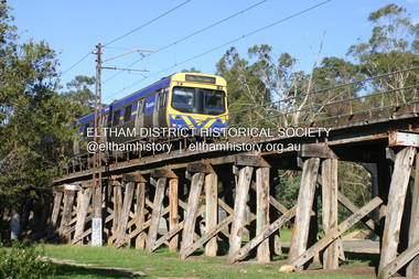
Photograph - Digital Photograph, Alan King, Eltham Railway Trestle Bridge, 28 December 2007
... bridge constructed between 1893 and 1910. At the opening, despite persistent drizzle, 300 children waving flags and banners were among the large crowd welcoming the first train, carrying official dignitaries, to Eltham. It had taken 24 years to bring the railway to Eltham. From then Eltham became a popular destination for outings. Mr Orford of Eltham recalled that after the railway came to Eltham ‘the craze for picnics on weekends and holidays began…. During the wattle season, wattle trains came to Eltham frequently. The visitors roamed the creek pulling great armfuls of wattle blossom to take back...bridge constructed between 1893 and 1910. At the opening, despite persistent drizzle, 300 children waving flags and banners were among the large crowd welcoming the first train, carrying official dignitaries, to Eltham. It had taken 24 years to bring the railway to Eltham. From then Eltham became a popular destination for outings. Mr Orford of Eltham recalled that after the railway came to Eltham ‘the craze for picnics on weekends and holidays began…. During the wattle season, wattle trains came to Eltham frequently. The visitors roamed the creek pulling great armfuls of wattle blossom to take back ...Covered under National Trust of Australia (Victoria) State Significance and Heritage Overlay, Nillumbik Planning Scheme. Published: Nillumbik Now and Then / Marguerite Marshall 2008; photographs Alan King with Marguerite Marshall.; p103 The Eltham railway trestle bridge is the only one of its kind still regularly used in Melbourne’s metropolitan railway network. Opened in 1902, it is also one of Victoria’s very few timber rail bridges that still carries trains.1 The bridge is part of the railway line extension from Heidelberg - extended to Hurstbridge in 1912. This extension resulted in one of the greatest social changes experienced in Eltham Shire, as it considerably lessened its isolation attracting tourists, artists and suburban commuters particularly after World War Two.2 The bridge has been classified by the National Trust as historically, scientifically, aesthetically and socially significant at state level. But this has not always been recognised, and in 1977, locals fought to save it from destruction. The Victorian Railways proposed to replace the bridge with an earth embankment and large culverts to avoid maintenance problems and fire. This was rejected by the Eltham Council who protested that the bridge helped maintain the area’s rural character, historic link and beauty, as well as avoiding possible serious flooding on the flood plain if a culvert was blocked. The bridge stands as part of a National Trust classified landscape which includes the Alistair Knox Park, named after the local conservationist and architect who helped to make Eltham famous for its mud-brick houses. The landscape includes tall and spreading manna gums and candlebarks, and the historic Shillinglaw Cottage. Artist Walter Withers, one of the Heidelberg School of painters, painted the bridge early in the 20th century. The 38 span single-track railway bridge over creek and road has 34 timber-beam spans and four steel-joist spans, supported by four-pile timber piers and timber abutments. It has almost 200m of timber deck. All of the timbers have been replaced over the years, but the only change to the bridge’s character was the addition of pylons and wiring for electric trains in 1923. A petition for a railway to the shire was first made in 1883. A large deputation of local citizens to the Commissioner of Railways proposed a route passing through Alphington to midway between Greensborough and Eltham up the Diamond Creek valley towards Queenstown and Kinglake. As a result the Princes Bridge-Heidelberg Railway was opened in 1888. From 1888 locals demanded a railway extension. Kangaroo Ground farmers in particular, led by Shire Councillor and Member for Evelyn, Ewen Cameron, said it would assist local farmers and orchardists send their produce to the Melbourne market. In 1890, before the severe economic Depression, an extension of the line to Hurst’s Bridge (now Hurstbridge) was included in a new Railways Bill. The parliamentary delegations were regaled with a banquet at Hurst’s barn and entertained by the Diamond Creek Brass Band, but the extension was abandoned when the Depression struck in 1892-1893. The extension of the railway to Eltham, completed in 1902, was one of the few built in those hard times. That is why the Eltham timber-trestle railway bridge is a rare example of a broad-gauge rail bridge constructed between 1893 and 1910. At the opening, despite persistent drizzle, 300 children waving flags and banners were among the large crowd welcoming the first train, carrying official dignitaries, to Eltham. It had taken 24 years to bring the railway to Eltham. From then Eltham became a popular destination for outings. Mr Orford of Eltham recalled that after the railway came to Eltham ‘the craze for picnics on weekends and holidays began…. During the wattle season, wattle trains came to Eltham frequently. The visitors roamed the creek pulling great armfuls of wattle blossom to take back with them to Melbourne’.3 In 1926 the railway line was electrified as part of the metropolitan rail network. But the Victorian Railways decided not to complete the formerly planned Diamond Valley Railway to Queenstown (now St Andrews) and Kinglake.This collection of almost 130 photos about places and people within the Shire of Nillumbik, an urban and rural municipality in Melbourne's north, contributes to an understanding of the history of the Shire. Published in 2008 immediately prior to the Black Saturday bushfires of February 7, 2009, it documents sites that were impacted, and in some cases destroyed by the fires. It includes photographs taken especially for the publication, creating a unique time capsule representing the Shire in the early 21st century. It remains the most recent comprehenesive publication devoted to the Shire's history connecting local residents to the past. nillumbik now and then (marshall-king) collection, eltham railway trestle bridge, eltham trestle bridge -
 Bendigo Historical Society Inc.
Photograph - AXEDALE BRIDGE
... bridge over dry creek ( possibly Campaspe or Axe Creek ?) Dead trees lying in creek. Large group of people, men women and children on bridge. Horse and vehicle at CR. Haystack in centre with stock yards. Inscriptions: On back...bridge over dry creek ( possibly Campaspe or Axe Creek ?) Dead trees lying in creek. Large group of people, men women and children on bridge. Horse and vehicle at CR. Haystack in centre with stock yards. Inscriptions: On back ...Sepia photograph. Wooden bridge over dry creek ( possibly Campaspe or Axe Creek ?) Dead trees lying in creek. Large group of people, men women and children on bridge. Horse and vehicle at CR. Haystack in centre with stock yards. Inscriptions: On back - in pencil 'Mrs Harris Axedale 21/-' Circular stamp and 1/2 circular stamp 'Royal Historical Society of Victoria, Bendigo Branch'. Pencil note front BR - indecipherable. History: Prev. Acc. No. MP211 Research indicates that this is the bridge over Axe Creek, on the Sugarloaf Road, Axedale. The property in the background belonged to Jonathan and Harriet Harris.place, landscape view -
 Bendigo Historical Society Inc.
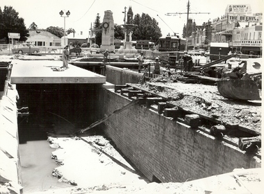
Photograph - BASIL MILLER COLLECTION: CHARING CROSS AND BRIDGE WORKS
... bridge works over creek. Two trams visible, Burnie 'Safety Car' (right) and Bogie Car (left). Baby Health Centre (extreme left), War memorial, Alexandra Fountain (centre), various Pall Mall businesses and Shamrock Hotel (top Right). '31/12/2773' written in pencil on back of photo....bridge works over creek. Two trams visible, Burnie 'Safety Car' (right) and Bogie Car (left). Baby Health Centre (extreme left), War memorial, Alexandra Fountain (centre), various Pall Mall businesses and Shamrock Hotel (top Right). '31/12/2773' written in pencil on back of photo. ...Black and white photo of Charing Cross showing bridge works over creek. Two trams visible, Burnie 'Safety Car' (right) and Bogie Car (left). Baby Health Centre (extreme left), War memorial, Alexandra Fountain (centre), various Pall Mall businesses and Shamrock Hotel (top Right). '31/12/2773' written in pencil on back of photo.person, individual, basil miller -
 Bendigo Historical Society Inc.
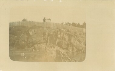
Photograph - POSTCARD - ANTICLINE ON BENDIGO CREEK
... Creek. Sepia print on postcard. Anticline in centre of photo. Paling fence extends along entire back of photo. Behind fence small weatherboard building (outhouse?) Written on back in pencil ' anticline in creek at Golden Square, area of old bridge...Creek. Sepia print on postcard. Anticline in centre of photo. Paling fence extends along entire back of photo. Behind fence small weatherboard building (outhouse?) Written on back in pencil ' anticline in creek at Golden Square, area of old bridge ...Postcard: anticline on Bendigo Creek. Sepia print on postcard. Anticline in centre of photo. Paling fence extends along entire back of photo. Behind fence small weatherboard building (outhouse?) Written on back in pencil ' anticline in creek at Golden Square, area of old bridge over Bgo creek' Stamped in blue ' Bendigo Institute of Technology, Geology Dept. 'place, gold, bendigo, anticline, bendigo creek -
 Bendigo Historical Society Inc.
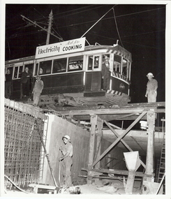
Photograph - BASIL MILLER COLLECTION: TRAM OVER BRIDGE WORKS
... bridge. Note: SEC colour scheme on tram and tram pole behind tram. On back of photo inscription under photo in albums: ''Tram over creek'' in pencil in top right corner. ...bridge. Note: SEC colour scheme on tram and tram pole behind tram. On back of photo inscription under photo in albums: ''Tram over creek'' in pencil in top right corner. ...BHS CollectionBlack and white photo of bogie tram crossing new bridge works on Charing Cross. 3 men visible on tram, 2 working on bridge and 1 underneath bridge. Note: SEC colour scheme on tram and tram pole behind tram. On back of photo inscription under photo in albums: ''Tram over creek'' in pencil in top right corner. 'Reduce to 5 1/2'' x 5. 66% Page 75' written in black ink.person, individual, basil miller -
 Bendigo Historical Society Inc.
Photograph - SANDHURST POST OFFICE
... LH front is creek and primitive wooden bridge (short span). Inscriptions: on back - written in ballpoint pen. ...LH front is creek and primitive wooden bridge (short span). Inscriptions: on back - written in ballpoint pen. ...Black and white photograph of a sketch of building (post office) with high roof and six skylight windows. Lean-to verandahs/ buildings in front of main building. LH front is creek and primitive wooden bridge (short span). Inscriptions: on back - written in ballpoint pen. 'Bendigo Vic Post Office, Sandhurst Vic 1850's' History: James Lerk 18/2/2000: 'View Point Bendigo, Post Office, looking West'buildings, post office, view point -
 Bendigo Historical Society Inc.
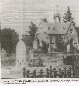
Newspaper - JENNY FOLEY COLLECTION: FINAL RESTING PLACE
... Final resting place: the Sandhurst cemetery in Bridge Street, Sandhurst, circa 1880s. NOTE: Photo incorrectly labelled. This chapel is at the Back Creek Cemetery in Carpenter Street Bendigo....Final resting place: the Sandhurst cemetery in Bridge Street, Sandhurst, circa 1880s. NOTE: Photo incorrectly labelled. This chapel is at the Back Creek Cemetery in Carpenter Street Bendigo. ...Bendigo Advertiser "The way we were" from 1999. Final resting place: the Sandhurst cemetery in Bridge Street, Sandhurst, circa 1880s. NOTE: Photo incorrectly labelled. This chapel is at the Back Creek Cemetery in Carpenter Street Bendigo.newspaper, bendigo advertiser, the way we were -
 Halls Gap & Grampians Historical Society
Photograph - Coloured
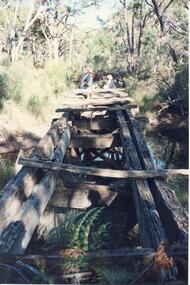
... An old bridge on the Heatherlie Quarry rail line at Back Creek, this line was used to transport sandstone from the quarry to Stawell....Halls Gap & Grampians Historical Society Centennial Hall 117-119 Grampians Road Halls Gap grampians An old bridge on the Heatherlie Quarry rail line at Back Creek, this line was used to transport sandstone from the quarry to Stawell. ...An old bridge on the Heatherlie Quarry rail line at Back Creek, this line was used to transport sandstone from the quarry to Stawell.Photo shows an old bridge with 3 adults at the end, one male standing and 2 adults sitting. The bridge consists of large wooden beams,cross beams and supports .water can be seen at the bottom of the depression. Bush surrounds the bridge.structures, bridges -
 Halls Gap & Grampians Historical Society
Photograph - Coloured
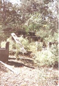
... An old bridge at Back Creek on the Heatherlie Quarry Rail line....Halls Gap & Grampians Historical Society Centennial Hall 117-119 Grampians Road Halls Gap grampians An old bridge at Back Creek on the Heatherlie Quarry Rail line. ...An old bridge at Back Creek on the Heatherlie Quarry Rail line.Photo shows the beginning of a bridge that has become dilapidated with time. Large beams lie around covered in weeds. Bushy growth has grown over the bridge.structures, bridges -
 Eltham District Historical Society Inc
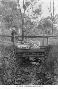
Photograph, The Rose Stereograph Company, Log Bridge, Eltham Road. Greensborough, c.1920
... A woman stands at the end of a log bridge over a creek looking towards the south along the unsealed roadway. The sun illuminates her back. ...Eltham District Historical Society Inc 728 Main Rd Eltham melbourne A woman stands at the end of a log bridge over a creek looking towards the south along the unsealed roadway. The sun illuminates her back. ...A woman stands at the end of a log bridge over a creek looking towards the south along the unsealed roadway. The sun illuminates her back. She is wearing a woollen knit beanie with edges rolled up, dark jacket and skirt, full length dark stockings and slip on dark leather shoes with raised heel, typical of the early 1920s. The creek is possibly feeding into the Karingal Yalloc. The direction of the road based on shadows is northwest as is the Eltham Road to Greensborough (present day Sherbourne, Karingal and St Helena roads). The creek is falling to the foreground so from south west to the north east, possibly feeding into the Karingal Yalloc, somewhere near presenet day Ramptons Road Reserve. This glass plate negative was used to manufacture postcards (1:1 printing) for commercial sale by the Rose Sterograph Company and its subsidiaries. George Rose founded the Rose Stereograph Company in 1880 and was joined by Herbert (Bert) Cutts in the early 20th Century. The pair formed a lifetime working partnership and strong personal friendship. Assisted by George’s two sons, Herbert George and Walter, and later by Neil Cutts, the Rose Stereograph Company continued its operations for more than 140 years. The company was initially built on stereographs, but as cinema took over and stereographs fell out of fashion, the Rose Stereograph Company developed Australia’s first commercially viable photographic postcard business. Specialising in postcards of iconic historical moments and significant landmarks, The Rose Stereograph Company became a staple of the Australian travel industry.This remarkable collection of glass plate negatives, transparencies, and postcards – arguably Australia’s most significant photography collection outside of public hands – has been passed down through the generations, surviving war, relocation, and the harsh Victorian climate. The historic Rose Stereograph collection is the culmination of George Rose’s dream of capturing and preserving precious moments in time and remains the legacy of the Rose and Cutts families. It is with great sadness that the Cutts family says goodbye to a collection that spans five generations and 140 years. The Cutts family understands that for these historically important pieces to rest with one family is to deny others the pleasure of their custodianship.Glass Plate Negative Size: 9.2 x 13.8 cmLog Bridge, Eltham Road, Greensborougheltham, postcard, travel, rose stereograph company, glass plate negative, creek, eltham road, greensborough, karingal road, karingal yallock, log bridge, sherbourne road, st helena road, women's fashion, rampton's road reserve, peter and elizabeth pidgeon collection -
 Eltham District Historical Society Inc
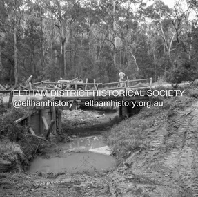
Negative - Photograph, J.A. McDonald, Heidelberg-Kinglake Road, Oct. 1959
... Job 56M431 Contractors Wolf and Wood Yow Yow Creek Bridge Showing condition October 1959 Bypass back upstream side under construction...Eltham District Historical Society Inc 728 Main Rd Eltham melbourne Job 56M431 Contractors Wolf and Wood Yow Yow Creek Bridge Showing condition October 1959 Bypass back upstream side under construction Record of various Shire of Eltham infrastructure works undertaken during the period of 1952-1962 involving bridge and road reconstruction projects, sometimes with Eltham Shire Council Project Reference numbers quoted. ...Job 56M431 Contractors Wolf and Wood Yow Yow Creek Bridge Showing condition October 1959 Bypass back upstream side under constructionRecord of various Shire of Eltham infrastructure works undertaken during the period of 1952-1962 involving bridge and road reconstruction projects, sometimes with Eltham Shire Council Project Reference numbers quoted. It was during this period that a number of significant improvements were made to roads and new bridges constructed within the shire that remain in place as of present day (2022). In many situations, the photos provide a tangible visible record of infrastructure that existed throughout the early days of the Shire. The album was put together by or under the direction of the Shire Engineer, J.A. McDonald.infrastructure, shire of eltham, bridge construction, heidelberg-kinglake road, 1959-10, road construction, scan - 120 format 6x6 negative, yow yow creek -
 Eltham District Historical Society Inc
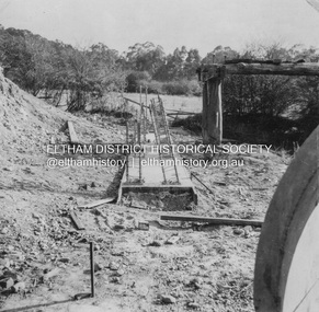
Album - Photograph, J.A. McDonald, Eltham-Greensborough Road, 1957
... Diamond Creek Bridge (Bridge Street Bridge) Greensborough abutment – Piles broken back and false floor poured for columns 1957...Eltham District Historical Society Inc 728 Main Rd Eltham melbourne Diamond Creek Bridge (Bridge Street Bridge) Greensborough abutment – Piles broken back and false floor poured for columns 1957 Record of various Shire of Eltham infrastructure works undertaken during the period of 1952-1962 involving bridge and road reconstruction projects, sometimes with Eltham Shire Council Project Reference numbers quoted. ...Diamond Creek Bridge (Bridge Street Bridge) Greensborough abutment – Piles broken back and false floor poured for columns 1957Record of various Shire of Eltham infrastructure works undertaken during the period of 1952-1962 involving bridge and road reconstruction projects, sometimes with Eltham Shire Council Project Reference numbers quoted. It was during this period that a number of significant improvements were made to roads and new bridges constructed within the shire that remain in place as of present day (2022). In many situations, the photos provide a tangible visible record of infrastructure that existed throughout the early days of the Shire. The album was put together by or under the direction of the Shire Engineer, J.A. McDonald.infrastructure, road construction, shire of eltham, bridge construction, bridge street bridge, eltham, eltham-greensborough road, 1957 -
 Eltham District Historical Society Inc
Album - Photograph, J.A. McDonald, Eltham-Yarra Glen Road, 19 Oct. 1956
... Eltham District Historical Society Inc 728 Main Rd Eltham melbourne Dixons Creek Road 19th October, 1956 Scour developing back onto road from Smedley’s property near Blease Road Record of various Shire of Eltham infrastructure works undertaken during the period of 1952-1962 involving bridge and road reconstruction projects, sometimes with Eltham Shire Council Project Reference numbers quoted. ...Dixons Creek Road 19th October, 1956 Scour developing back onto road from Smedley’s property near Blease RoadRecord of various Shire of Eltham infrastructure works undertaken during the period of 1952-1962 involving bridge and road reconstruction projects, sometimes with Eltham Shire Council Project Reference numbers quoted. It was during this period that a number of significant improvements were made to roads and new bridges constructed within the shire that remain in place as of present day (2022). In many situations, the photos provide a tangible visible record of infrastructure that existed throughout the early days of the Shire. The album was put together by or under the direction of the Shire Engineer, J.A. McDonald.infrastructure, road construction, shire of eltham, bridge construction, eltham-yarra glen road, 1956-10-19, dixons creek bridge, dixon's creek road, floods -
 Eltham District Historical Society Inc
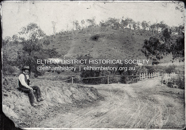
Negative - Photograph, Mr Belot smokes his pipe whilst resting at Cottle's Bridge, c.1990 (c.1890)
... The area, previously known as Back Creek, was named after Thomas Cottle, who settled in the district in the 1870s, and the original bridge over the Diamond Creek on the road to Strathewen. ...The area, previously known as Back Creek, was named after Thomas Cottle, who settled in the district in the 1870s, and the original bridge over the Diamond Creek on the road to Strathewen. ...Copy of original photograph. The area, previously known as Back Creek, was named after Thomas Cottle, who settled in the district in the 1870s, and the original bridge over the Diamond Creek on the road to Strathewen. The original bridge (seen in the photo) was replaced with a new timber bridge at a cost of £1,500, the tender being awarded to a contractor named Birch who commenced work in June 1927. The gentleman in the photo who is resting whilst having a smoke of his pipe is a member of the Belot family.Roll of 35mm Black and White negative film, 3 strips, (1 of 14 frames)Film - Agfa Ortho 25belot, bridge, cottles bridge, cottles bridge-strathewan road, diamond creek (creek), heidelberg-kinglake road -
 Eltham District Historical Society Inc
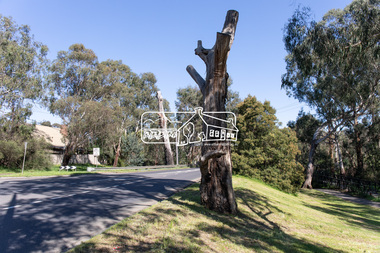
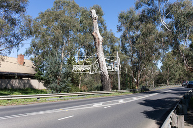
Photograph, Peter Pidgeon, Manna Gum, Main Road, Eltham South, 8 Sep. 2021
... This significant tree located near the Main Road Bridge over the Diamond Creek at Eltham dates back to approximately 1870-1880. ...Eltham District Historical Society Inc 728 Main Rd Eltham melbourne This significant tree located near the Main Road Bridge over the Diamond Creek at Eltham dates back to approximately 1870-1880. ...This significant tree located near the Main Road Bridge over the Diamond Creek at Eltham dates back to approximately 1870-1880. Though dead now, its trunk has been left as a wildlife habitat.These trees are not only significant for the natural environment but also present a navigational beacon back in time as the environmental landscape is developed around them.Born Digitaleltham south, main road bridge, manna gum, significant tree -
 Eltham District Historical Society Inc
Photograph, Peter Pidgeon, Manna Gum, Main Road, Eltham South, 8 Sep. 2021
... This significant tree located near the Main Road Bridge over the Diamond Creek at Eltham dates back to approximately 1870-1880. ...Eltham District Historical Society Inc 728 Main Rd Eltham melbourne This significant tree located near the Main Road Bridge over the Diamond Creek at Eltham dates back to approximately 1870-1880. ...This significant tree located near the Main Road Bridge over the Diamond Creek at Eltham dates back to approximately 1870-1880. Though dead now, its trunk has been left as a wildlife habitat.These trees are not only significant for the natural environment but also present a navigational beacon back in time as the environmental landscape is developed around them.Born Digitaleltham south, main road bridge, manna gum, significant tree