Showing 38 items matching " bluestone quarries"
-
 Flagstaff Hill Maritime Museum and Village
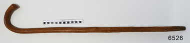
Accessory - Walking Stick, William Dale, early 1900's
... ...dale bluestone quarries...In the words of the Donor, Betty Stone, "This walking stick was made by William Dale from wood obtained from his property Bluestone Quarries situated at Wangoom, Warrnambool. ...Made by William Dale in the early 1900's of wood from his property, "Dale Bluestone Quarries", Wangoom, Warrnambool. From the 'Chamberlain Dale and Lees Collection'....Dale Bluestone Quarries, Wangoom, Warrnambool, Great Ocean Road, Victoria, 3280, Australia...Made by William Dale in the early 1900's of wood from his property, "Dale Bluestone Quarries", Wangoom, Warrnambool. From the 'Chamberlain Dale and Lees Collection'. ...In the words of the Donor, Betty Stone, "This walking stick was made by William Dale from wood obtained from his property Bluestone Quarries situated at Wangoom, Warrnambool. William Dale, the son of William Booth and Hannah (nee Broadbent) Dale was born on 8 July 1828 in Saddleworth, Yorkshire, England. He emigrated to Australia in 1852 and seven years later purchased twenty acres of land in the shire of Wangoom, Warrnambool where he operated a quarry known as The Dale Bluestone Quarries. According to family legend, when William and his wife Elizabeth (nee Chamberlain) first moved into their bluestone cottage on the property, it was surrounded by dense bush that abounded with wildlife. William Dale used this walking stick in his later years. Although physically bent after years of toil, his grandchildren remembered him wheeling his barrow and walking with his stick around the quarries when aged well over eighty years. William Dale died at his residence on 14 December 1913 aged 85 years." (Note: For additional information please refer to Betty Stone’s book “Pioneers and Places - A History of three Warrnambool Pioneering Families” ie. Chamberlain, Dale and Lees Families) This item is associated with the families of Chamberlain, Dale and Lees. These families are listed in the "Pioneers' Register" for Warrnambool Township and Shire, 1835-1900, published by A.I.G.S. Warrnambool Branch. The handmade walking stick was made from local resources.Walking Stick, polished wood with grain and knots showing. Brass tip, 'J' shaped handle. Made by William Dale in the early 1900's of wood from his property, "Dale Bluestone Quarries", Wangoom, Warrnambool. From the 'Chamberlain Dale and Lees Collection'.flagstaff hill, warrnaflagstaff hill, warrnambool, shipwrecked coast, flagstaff hill maritime museum, maritime museum, shipwreck coast, flagstaff hill maritime village, great ocean road, chamberlain, dale, lees, stone, betty stone, warrnambool pioneers, mbool, shipwrecked-coast, flagstaff-hill, flagstaff-hill-maritime-museum, maritime-museum, shipwreck-coast, flagstaff-hill-maritime-village, dale bluestone quarries, william dale, walking aid, walking stick, mobility aid -
 Flagstaff Hill Maritime Museum and Village
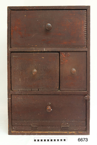
Furniture - Cupboard, c. 1890
... ...dale bluestone quarries...One drawer made from a gelignite packing case is of special significance as the Dale family owned a bluestone quarry known as The Dale Bluestone Quarries at Wangoom situated about three miles east of Warrnambool. ...One drawer made from a gelignite packing case is of special significance as the Dale family owned a bluestone quarry known as The Dale Bluestone Quarries at Wangoom situated about three miles east of Warrnambool. ...The materials used to build the colonial cupboard have been gathered from various sources and recycled. In those days, it was normal to keep all manner of items 'just in case' they could be repurposed for another item. The brand "Laurel" on one of the wooden panels is from the Mobil Oil company's kerosene. There In the words of the donor, Betty Stone, "Made by Ellis Dale of Latrigg Wangoom, Warrnambool c 1890. The cupboard consists of packing cases stamped with original brand names. One drawer made from a gelignite packing case is of special significance as the Dale family owned a bluestone quarry known as The Dale Bluestone Quarries at Wangoom situated about three miles east of Warrnambool. Ellis Dale, second son of William Dale and Elizabeth (nee Chamberlain) Dale, was born in Wangoom, Warrnambool on 21 November 1860. His father, William Dale, a quarryman from Saddleworth, Yorkshire migrated to Australia in 1852; seven years later - in 1859- he purchased the quarries on twenty acres of land situated in Wangoom at the corner of what is now known as Dales and Aberline Roads. Later, when his two eldest sons, William Jnr and Ellis, reached ten or eleven years of age they worked with their father in the quarries. The work was arduous and dangerous as gelignite was used to blast the bluestone. In 1890 Ellis Dale married Ann Lees, daughter of Lees and Sarah (nee Chamberlain) Lees of Wangoom, Warrnambool. Initially Ellis and Ann Dale resided in a two roomed bluestone cottage which Ellis built a little further up the hill from his parents' home on the Dale family property. A few years later, in order to accommodate their growing family, additional rooms were added making a spacious, comfortable weatherboard home situated in Dales Road which they named Latrigg. Ellis Dale constructed this cupboard soon after he and Ann first set up home in their little stone cottage in 1890. When the home was rebuilt, the home-made cupboard was moved into the larger kitchen, and although Latrigg was well furnished, it remained in the corner between the kitchen door and the large wood stove where it served its purpose very well as it was used for storing ironing utensils. The lower compartment with the hinged drop-door was designed to store the flat irons which were heated on the wood stove, while the ironing blanket and cover, iron holders and other items were stored in the drawers. The Dale quarrying and contracting business existed in Wangoom, Warrnambool for over eighty years as after William Dale’s death. Ellis Dale together with his son lvor, continued on until he died in 1940. (Note: For additional information please refer to Betty Stone’s book “Pioneers and Places - A History of three Warrnambool Pioneering Families” i.e. Chamberlain, Dale and Lees Families)This item is associated with families of Chamberlain, Dale and Lees. These families are listed in the "Pioneers' Register" for Warrnambool Township and Shire, 1835-1900, published by A.I.G.S. Warrnambool Branch.Cupboard, rare example of a Colonial Cupboard, wooden. Made by Ellis Dale from packing cases; several brand names are evident inc. Gelignite and Laurel. Cupboard is lined with newspaper and wallpaper. Panels on left side are braced by attaching a metal scraper. Comprises four compartments, three have round wooden handles, lower compartment has a hinged, drop down door. (From the Chamberlain, Dale and Lees Collection)Brands on wooden panels of cupboard include "Gelignite" and "Laurel" (Laurel is a brand of kerosene)flagstaff hill, warrnambool, shipwrecked coast, flagstaff hill maritime museum, maritime museum, shipwreck coast, flagstaff hill maritime village, great ocean road, chamberlain, dale, lees, stone, betty stone, warrnambool pioneers, dale bluestone quarries, wangoom, cupboard, colonial cupboard, furniture, gelignite, packing crate, ellis dale, laurel -
 Sunshine and District Historical Society Incorporated
Photograph - Bluestone quarry
... Bluestone quarry...Bluestone quarry...Stone quarry probably bluestone On the site of where the Sunshine Plaza now stands Service Street Hampshire Road and Hertford Road Note center bottom features head of what appears to be bluestone pitchers used for forming gutters at sides of streets Three horse drawn tip drays and most likely owner drivers This was the most commonly used means of transporting stone up to the early 1930s The structures featured housed stone crushing equipment...Quarry Sunshine Plaza Hampshire Road Sunshine Stone quarry probably bluestone On the site of where the Sunshine Plaza now stands Service Street Hampshire Road and Hertford Road Note center bottom features head of what appears to be bluestone pitchers used for forming gutters at sides of streets Three horse drawn tip drays and most likely owner drivers This was the most commonly used means of transporting stone up to the early 1930s The structures featured housed stone crushing equipment Bluestone quarry Photograph Bluestone quarry ...Stone quarry probably bluestone On the site of where the Sunshine Plaza now stands Service Street Hampshire Road and Hertford Road Note center bottom features head of what appears to be bluestone pitchers used for forming gutters at sides of streets Three horse drawn tip drays and most likely owner drivers This was the most commonly used means of transporting stone up to the early 1930s The structures featured housed stone crushing equipmentquarry, sunshine plaza, hampshire road, sunshine -
 Sunshine and District Historical Society Incorporated
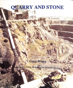
Book - Quarry and Stone, Melbourne's Living Museum of the West, 1993
... Bluestone... Quarry...Quarry and Stone - Bluestone quarrying, stonemasonry and building in Melbourne's west....References to Sunshine are on pages 21, 29 and 30 Bluestone Quarry The history of quarrying bluestone in the 19th century in Melbourne's west Quarry and Stone - Bluestone quarrying, stonemasonry and building in Melbourne's west. ...The history of quarrying bluestone in the 19th century in Melbourne's westSlim A 5 book, well-illustrated, and a picture of Market Street Quarry on the front covernon-fictionThe history of quarrying bluestone in the 19th century in Melbourne's westbluestone, quarry -
 Bendigo Historical Society Inc.
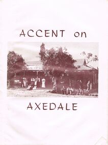
Document - BOOKLET: ACCENT ON AXEDALE
... ... Bluestone Quarries...G. O'Neill Bluestone Quarries Threshing Teams Hotels General Store and Post Office. ...Booklet: ''Accent on Axedale'', published by the Centenary and Back to Axedale Committee 1970. 36 pages with photographs. Chapters on: Early Settlement; Churches; Education; Police; Municipal Affairs; Commerce; Cemeteries; Race Course Reserve; The Railway (O'Keefe); Eppalock Weir; The Hall; The Wars; C.W.A; Camp Sites; C.F.A; Axedale Progress Association; Sport;Alfred Ruskin Publications. Freelance Press, 61-63 City South Melbourne. 3205axedale, history, early settlement, axedale sporting club, indoor bowls, axedale progress association, c.w.a., country fire association.eppalock weir, the railway, race course reserve, cemeteries, axedale farmers club, the pitcher dressers poem by w. g. o'neill, bluestone quarries, threshing teams, hotels, general store and post office. education, churches, early settlement. -
 Hume City Civic Collection
Photograph, Early 1990's
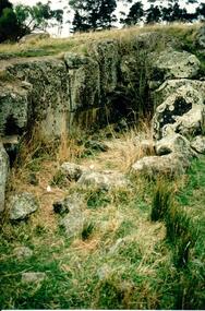
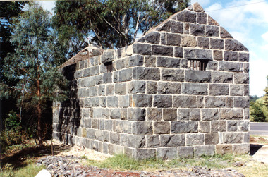
... This is the remains of a bluestone quarry on the 'Oaklands' property at Oaklands Junction....This is the remains of a bluestone quarry on the 'Oaklands' property at Oaklands Junction. stone structures oaklands quarry george evans collection A coloured photograph in portrait format of a basalt rock ruined structure which has been dug into a hillside with a line of trees in the background. ...This is a photograph of one of the many stone ruins which can be seen in the Sunbury area and surrounding districts. These ruins are found in varying degrees of structural damage caused by erosion, vegetation growth and vandalism. This is the remains of a bluestone quarry on the 'Oaklands' property at Oaklands Junction.A coloured photograph in portrait format of a basalt rock ruined structure which has been dug into a hillside with a line of trees in the background.stone structures, oaklands quarry, george evans collection -
 Darebin Parklands Association
Rockbeare Park 1970s, 1973-1980
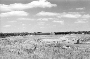
... Shows tip site and makeshift toilet probably from the days of the former bluestone quarry. Darebin Enterprise Centre is in the distance. ...Shows tip site and makeshift toilet probably from the days of the former bluestone quarry. Darebin Enterprise Centre is in the distance. ...B&W photograph of the area which was to become the Darebin Parklands. Shows tip site and makeshift toilet probably from the days of the former bluestone quarry. Darebin Enterprise Centre is in the distance. This item and all other Darebin Parklands Association archival material is now held by State Library Victoria (Accession No: YMS 13746). Please contact State Library Victoria if access is required. -
 Darebin Parklands Association
Rockbeare Park 1970s, 1973-1980
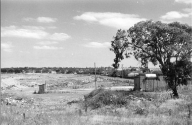
... Shows toilet and other buildings which were probably part of old bluestone quarry operation. The tree at right is still standing (at 2014). ...Shows toilet and other buildings which were probably part of old bluestone quarry operation. The tree at right is still standing (at 2014). ...B&W photograph of the area which was to become the Darebin Parklands. Shows toilet and other buildings which were probably part of old bluestone quarry operation. The tree at right is still standing (at 2014). The path behind is the extension of Separation Street. This item and all other Darebin Parklands Association archival material is now held by State Library Victoria (Accession No: YMS 13746). Please contact State Library Victoria if access is required. -
 Sunshine and District Historical Society Incorporated
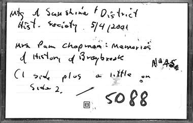
Audio - Mrs Pam Chapman Memories Of The History Of Braybrook Audio Tape, 23/4/1995
... Braybrook's history includes early white settlement in the 1840s, the establishment of the Braybrook Shire in 1871 and a period of industrial development in the late 1800s with activities like bluestone quarrying. In the 1950s the Housing Commission of Victoria developed Braybrook as a social housing hub for the post war population boom. ...Brimbank Library, 301 Hampshire Road, Sunshine 3020. melbourne Braybrook's history includes early white settlement in the 1840s, the establishment of the Braybrook Shire in 1871 and a period of industrial development in the late 1800s with activities like bluestone quarrying. In the 1950s the Housing Commission of Victoria developed Braybrook as a social housing hub for the post war population boom. ...Braybrook's history includes early white settlement in the 1840s, the establishment of the Braybrook Shire in 1871 and a period of industrial development in the late 1800s with activities like bluestone quarrying. In the 1950s the Housing Commission of Victoria developed Braybrook as a social housing hub for the post war population boom. The suburb has since seen a mix of community development, including the establishment of the Vietnamese Buddhist community's Quanh Minh Temple. The original Braybrook Shire became part of the City of Sunshine and then the City of Brimbank.Meeting At Sunshine & District Hist Society 5/4/2001 Mrs Pam Chapman Memories of History of Braybrookshire of braybrook, pam chapman -
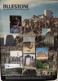 Sunshine and District Historical Society Incorporated
Poster - Bluestone Melbourne's Western Region - Bluestone & basalt quarried rocks in buildings Poster, Living Museum of the West, 1988
... A coloured poster depicting bluestone, basalt and quarrying for buildings in the western region of Melbourne. ...Bluestone Melbourne's Western Region|Dean Bloxidhe Stonemason Geelong Road Footscray|St. Mary's Catholic Church Cecil Street Williamstown|Historic Shearing Shed Werribee Park|Quarry Market Street Sunshine|Primary School No 252 Geelong Road Footscray|Tombstone Footscray Cemetery|Out-building Werribee Park|Bluestone Cottage Albert Street Williamstown|Bluestone Bridge over the Kororoit Creek Keilor-Melton Road...Poster Bluestone Melbourne's Western Region - Bluestone & basalt quarried rocks in buildings Poster Living Museum of the West ...Bluestone Melbourne's Western Region|Dean Bloxidhe Stonemason Geelong Road Footscray|St. Mary's Catholic Church Cecil Street Williamstown|Historic Shearing Shed Werribee Park|Quarry Market Street Sunshine|Primary School No 252 Geelong Road Footscray|Tombstone Footscray Cemetery|Out-building Werribee Park|Bluestone Cottage Albert Street Williamstown|Bluestone Bridge over the Kororoit Creek Keilor-Melton Roadquarry, blue stone -
 Warrnambool and District Historical Society Inc.
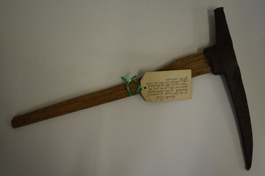
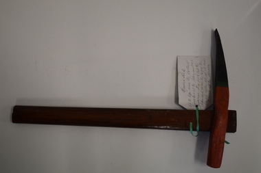
Tools, Miner's Pick, Early 20th century
... Warrnambool also once had several bluestone quarries on the outskirts of the town. ...Warrnambool also once had several bluestone quarries on the outskirts of the town. Limestone Quarries in Warrnambool Quarrying in Warrnambool Warrnambool History This miner’s pick has a wooden handle with rounded sides tapering to a wider end. ...This miner’s pick was of the type used to extract limestone at the Warrnambool limestone quarries, mainly for buildings and walls. This pick cut the sides and the top of the block and then it was levered off with a crowbar at an angle of about 30° to 40°. These blocks were then reduced to the required size using cross cut saws. There were about 12 limestone quarries operating in Warrnambool in the 19th century and limestone was extensively quarried for about 85 years to the 1930s when quarrying ceased. Today there has been a small revival in the Warrnambool area in the use of limestone blocks for building. Warrnambool also once had several bluestone quarries on the outskirts of the town. This miner’s pick has a wooden handle with rounded sides tapering to a wider end. The wood is weather-worn and split in places, especially at the top end. The pick is metal with a curved shape that tapers to a point at one end. The metal near the other end has a cavity into which is inserted the wider end of the wooden handle. limestone quarries in warrnambool, quarrying in warrnambool, warrnambool history -
 Warrnambool and District Historical Society Inc.
Tool, Miner's Pick
... Warrnambool also once had several bluestone quarries on the outskirts of the town. ...Warrnambool also once had several bluestone quarries on the outskirts of the town. This miner’s pick is of considerable interest as an example of the type used in quarrying limestone in Warrnambool . ...This miner’s pick was of the type used to extract limestone at the Warrnambool limestone quarries, mainly for buildings and walls. This pick cut the sides and across the top of the block and then the block was levered off the strata using a crowbar at an angle of 30° or 40°. These blocks were then reduced to the required size using cross-cut saws. There were about 12 limestone quarries operating in Warrnambool in the 19th century and limestone was extensively quarried for about 85 years to the 1930s when the quarrying ceased. Today there has been a small revival in the use of limestone blocks for building. Warrnambool also once had several bluestone quarries on the outskirts of the town. This miner’s pick is of considerable interest as an example of the type used in quarrying limestone in Warrnambool . Quarrying was once an important industry in Warrnambool. This miner’s pick has a short wooden handle with a metal stud inserted at the bottom end. The handle is rounded on the sides and tapers slightly from the top to the bottom. The metal pick has a curved shape with one blunt end and one sharp end. It has a cavity in the end nearest the blunt end and the wooden handle slots into this. The pick is painted black, green and orange, perhaps for display purposes. A handwritten information tag is attached to the handle. quarrying in warrnambool, limestone quarries in warrnambool -
 Lake Bolac & District Historical Society
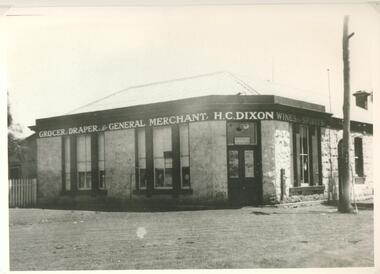
Photograph - Black and white photograph, Dixon's Store Lake Bolac, 1937
... Dixon's Store Lake Bolac built of locally quarried bluestone in 1868. This photo is circa 1938. ...Lake Bolac & District Historical Society 2110 Glenelg Highway Lake Bolac grampians Dixon's Store Lake Bolac built of locally quarried bluestone in 1868. This photo is circa 1938. ...Dixon's Store Lake Bolac built of locally quarried bluestone in 1868. This photo is circa 1938. Harold Dixon proprietor.black and white photographharold dixon, store, draper, grocer, general merchant, wines, spirits, bluestone -
 Bendigo Historical Society Inc.
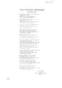
Document - The Pitcher Dressers, W.G. O'Neill, Unknown
... quarry...Napthali Ingham...pitchers...pitcher dressers...bluestone...In the 1860’s Napthali Ingham selected land in Axedale and opened a bluestone quarry beside the river later known as Ingham Hill. ...In the 1860’s Napthali Ingham selected land in Axedale and opened a bluestone quarry beside the river later known as Ingham Hill. ...Axedale is well known for its Bluestone. Early on the quarries employed a large number of people. In the 1860’s Napthali Ingham selected land in Axedale and opened a bluestone quarry beside the river later known as Ingham Hill. The quarry produced dressed curbing and pitchers for use in Bendigo and Melbourne. This bluestone can be seen throughout Axedale in the churches, the bridge over the Campaspe River and guttering in the township. The quarry also supplied bluestone products further afield, for example road metal. Napthali Ingham, the owner of one of the first quarries in Axedale, arrived in Victoria from Lancashire, England, some time before 1860, and settled in Brunswick, Victoria. He may have been building his home in Ewen[sic] Street in 1860, at approximately 31 years of age, when he placed two advertisements in The Argus, October 10. One called for tenders for carting "upwards of 100 perches of rubbish to Sandridge." The other calls for tenders to supply "800 bushels of Geelong Roche Lime." His address, given for the purpose of the advertisements, is Ewen Street, Brunswick. There were a number of quarries and clay pits in Brunswick at this time and by July 9, 1861, Ingham was operating a quarry and contracting services to local councils and boroughs for road works, including Sydney Road. He also operated the True Briton Hotel in Ewen Street. Ingham continued his quarry works and business dealings in the Brunswick area for a few years and, around 1872, was contracting for the City of Bendigo. He eventually moved to Axedale, between Bendigo and Heathcote, where he took up land and opened a bluestone quarry on the east bank of the Campaspe River. As he had difficulty transporting bluestone to Bendigo, he wrote a letter to The Bendigo Advertiser, suggesting a tramway be laid between Sandhurst (Bendigo) and Axedale. Over the next ten years or so, he modified this suggestion to a rail line connecting Sandhurst, Axedale and Heathcote to the North East line at Seymour. This suggestion did not materialise in its entirety, but it eventually resulted in what became the Wandong, Heathcote and Sandhurst Rail Line, the first sections, Bendigo-Heathcote and Wandong-Kilmore, opening October 1, 1888. In the 1870s, Ingham built the Quarry Hotel which is now the crumbling ruins adjoining Ingham Road on the east side of the Campaspe River.. Its condition is worsening as time passes. Ingham intended to have a tramline constructed from his Axedale bluestone quarry to the new rail line. This also did not happen but he was successful in getting a wood siding provided at the location that is today's Hanson's Quarry. Evidence of the rail siding are still evident at the site in 2025. Ingham's quarry is now owned by Hansen Quarries Ingham died in 1909 and the rail line that grew out of his suggestion lasted until 1958 when it was closed from Bendigo to Heathcote. The Heathcote Junction section was closed in 1968. Another quarry was owned and operated by Brasier, Riley and Nelson. 'This well known firm of contractors have a most extensive plant and all the latest improved machinery required for the supply of kerbstone, pitchers, monumental work and dressed bluestone metal for road making. ('Bendigo & District, 1902') 1. One page typed poem, written by W.G. O'Neill, titled 'The Pitcher Dressers, (Quarrymen). The poem tells the story of three Rowan brothers who came to the Axedale Quarry: 'They came to work on Axedale stone, Big contracts came that way, As pitcher dressers they could earn, Their thirty bob a day.' 2. Three copies of newspaper articles relating to quarry work and employees attached to poem: information regarding Brasier, Riley and Nelson, contractors (Bendigo and District 1902); 'The Stone Quarry Grievance' (Bendigo Advertiser, 15 June, 1959, p2); 'A Restriction Upon Industry' (Bendigo Advertiser, 2 June, 1859). Article 'A Restriction Upon Industry" details the anomalies that exist between working the quartz reefs for gold and quarrying for building stone. The cost of obtaining a license to 'quarry stone is 50 pounds sterling which must be paid down in order to merely prospect the ground. Some people who took out a lease to work a reef were actually 'looking for building stone'. On bottom of poem, W.G. O'Neill, Bendigo. Pupil of Axedale School, 1908-1917.axedale, quarry, napthali ingham, pitchers, pitcher dressers, bluestone, campaspe river, quarry hotel, rowan brothers -
 Victoria Police Museum
Police stations (Aitken's Gap)
... The gaol (used to house prisoners and also gold en route to Melbourne) was built in 1857 from bluestone quarried in the area. The roof was made of slate. ...The gaol (used to house prisoners and also gold en route to Melbourne) was built in 1857 from bluestone quarried in the area. The roof was made of slate. ...Aitken's Gap, otherwise known as The Gap or Buttlejork, and 3km west of Sunbury, was established as a township in 1845. It is in the area which is now bordered by the Calder Highway and Gap Road. The village was named after John Aitken, a Port Phillip pastoralist who took up the Mount Aitken run in 1836. Aitken's Gap Police Barracks (in the District of Bourke) opened in 1853 and was staffed by two Mounted Constables and one Foot Constable. The gaol (used to house prisoners and also gold en route to Melbourne) was built in 1857 from bluestone quarried in the area. The roof was made of slate. In 1861 it was staffed by 1 Mounted Senior Constable and 1 Foot Constable. The Barracks closed in 1863 when the Bendigo rail line was completed and the gold was transported to Melbourne by rail. All the buildings, except the gaol, were moved to Sunbury. The land was sold in 1870 and in 1989 the current owner donated the building to the Sunbury Police. The original building was dismantled, restored and rebuilt outside Sunbury police station.15 colour photos and 1 black and white photopolice stations; aitken's gap police station -
 Flagstaff Hill Maritime Museum and Village
Domestic object - Writing Slope, early 20th century
... Ellis Dale, born 21 November 1860, was the second son of William and Elizabeth Dale, of Dale Bluestone Quarries Wangoom. He worked with his father at the quarries, and continued, after his father's death, to operate the family business with his son lvor until he died, aged 79 years, on 2 August 1940. ...Ellis Dale, born 21 November 1860, was the second son of William and Elizabeth Dale, of Dale Bluestone Quarries Wangoom. He worked with his father at the quarries, and continued, after his father's death, to operate the family business with his son lvor until he died, aged 79 years, on 2 August 1940. ...In the words of the donor, Betty Stone, "This fitted writing slope box belonged to Ellis Dale of “Latrigg”, Wangoom, Warrnambool, and has an inscription “E. Dale”, hand written by Ellis on a small brass plaque featured on the lid. Ellis Dale, born 21 November 1860, was the second son of William and Elizabeth Dale, of Dale Bluestone Quarries Wangoom. He worked with his father at the quarries, and continued, after his father's death, to operate the family business with his son lvor until he died, aged 79 years, on 2 August 1940. Although the tradition was that the writing box was originally owned by Ellis's father, William Dale, there is some doubt that he brought it with him from England when he migrated in 1852 - however, we do know that it is at least one hundred years old. (Note: For additional information please refer to my book “Pioneers and Places - A History of three Warrnambool Pioneering Families” ie. Chamberlain, Dale and Lees Families)This item is associated with the Warrnambool pioneer families of Chamberlain, Dale and Lees. These families are listed in the Pioneers' Register for Warrnambool Township and Shire, 1835-1900, published by A.I.G.S. Warrnambool Branch. The item is significant for its association with a ‘glory box’ or hope chest’, a tradition of single ladies making and collecting a range of linen and other domestic items in preparation for their future marriage.Polished wooden Writing Slope or Travellers Desk. Owned by Ellis Dale. Box opens to be a sloped writing desk, with a leather writing surface decorated with a gold leaf border, and several compartments; one has a slightly concaved cover that pivots to open. Leather-covered boards hinge at the centre, and both sides lift, revealing further storage. Brass protectors on top corners, inlaid brass strengthening supports on two corners. Brass slide-releasing catches secure writing base as desk closes. The brass shield centre of the lid is engraved. Part of the 'Chamberlain Dale Lees Collection.Engraved shield on lid "E.Dale / Wangoom"flagstaff hill, warrnambool, shipwrecked coast, flagstaff hill maritime museum, maritime museum, shipwreck coast, flagstaff hill maritime village, great ocean road, chamberlain, dale, lees, stone, betty stone, warrnambool pioneers, writing slope, writing box, traveller's desk, portable desk, lap desk, ellis dale -
 Lake Bolac & District Historical Society
Black and white photograph, Veale Brother's Store
... It was constructed of locally quarried bluestone and still stands in 2016. ...It was constructed of locally quarried bluestone and still stands in 2016. black and white photograph Veale Brother's Store Black and white photograph ...Pictured are wool wagons outside the Veale Brother's store in Lake Bolac. The Veale Family ran this store from 1874 through to 1938 when it was bought by Harold Dixon. It was constructed of locally quarried bluestone and still stands in 2016. black and white photograph -
 Lake Bolac & District Historical Society
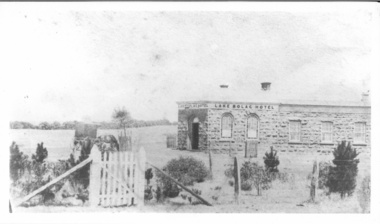
Photograph - Lake Bolac Hotel 1862, Lake Bolac Hotel 1862
... James Brown originally established a "shanty" in 1856, then built a wooden hotel and then erected the current bluestone hotel in 1862. It is made from locally quarried bluestone. ...James Brown originally established a "shanty" in 1856, then built a wooden hotel and then erected the current bluestone hotel in 1862. It is made from locally quarried bluestone. ...Lake Bolac Hotel constructed in 1862 following the establishment of a 'shanty' on the same site by James Brown in 1856. James Brown originally established a "shanty" in 1856, then built a wooden hotel and then erected the current bluestone hotel in 1862. It is made from locally quarried bluestone. In early years the hotel served the community for church services, as a barber-shop and as a morgue. -
 Linton and District Historical Society Inc
Photograph, 'Glenfine' Shearing Shed, 1890
... The present house was built by the Rowes in 1872 of bluestone quarried on the property with a cement render overall. ...The present house was built by the Rowes in 1872 of bluestone quarried on the property with a cement render overall. ...In July 1840, Glenfine, consisting of 31,440 acres, was acquired by Thomas Downie. In March 1842 the 'Right of Run' was taken up by Thomas Chirnside who with an imported stallion 'Delapre' ran a horse stud. He apparently lived here for ten years and employed a gardener with a wife and five children from Hobart, Tasmania. Only some blocks of stone and a few trees remain of their homestead. In 1853 the property was transferred to Dr. John Chirnside, an elder brother of Thomas Chirnside. In 1857, William Rowe of Naringal purchased Glenfiine where he and his family lived until 1904 when it was bought by Richard Howell's estate. It was then 39,000 acres. The present house was built by the Rowes in 1872 of bluestone quarried on the property with a cement render overall. The architect was H.R. Casselli. Gold was found on the property and by 1898 the township of Hollybush was first reported, situated at either side of the front entrance, on the Cressy Road. The land for the township was given by William Rowe. In 1911 R.C. Howell, son of Richard Howell, became the owner, followed by his son in 1960. By 1990 Hollybush had a population of 426 persons. All of the early history of Glenfine, documents etc., were destroyed when Naringal homestead was burnt down in 1944. Glenfine was classified by the National Trust in 1974 and is on the Heritage Commission Register. Mounted black and white image of a large group of men and boys in front of a weatherboard shearing shed. The men are each holding a pair of hand shears. One young man is kneeling on top of a wool bale. A small blue biro 'x' identifies W. Todd. Glenfine was a pastoral station, and the original homestead still stands.shearing sheds, shearers, rural activity, william todd, glenfine pastoral station, thomas chirnside, thomas downie, richard howell, william thomas rowe -
 Flagstaff Hill Maritime Museum and Village
Accessory - Wallet, Daisy Welsh, 1920s
... He arrived in Australia in 1852 and seven years later was operating a quarry on land purchased in Wangoom, Warrnambool known as The Dale Bluestone Quarries. Dale forebears in Yorkshire were first recorded as "clothiers" ( ie weavers of cloth) in the Saddleworth parish records dated 1764; following generations also continued the tradition of producing hand woven cloth as a home industry. ...He arrived in Australia in 1852 and seven years later was operating a quarry on land purchased in Wangoom, Warrnambool known as The Dale Bluestone Quarries. Dale forebears in Yorkshire were first recorded as "clothiers" ( ie weavers of cloth) in the Saddleworth parish records dated 1764; following generations also continued the tradition of producing hand woven cloth as a home industry. ...In the words of the Donor, Betty Stone, "The wallet is one of a set of two items. They were designed, hand-sewn sewn and embroidered with raffia by my mother Daisy Elvena (nee Dale) Welsh. Daisy Elvena Dale (born 27 October 1899) daughter of Ellis and Ann (nee Lees) Dale, of Latrigg, Wangoom, Warrnambool, married Raymond Welsh in 1922. A few years later – approximately 1928- Daisy made these two articles, which she used, particularly during the Depression years. The important factor concerning these bags is that they were made with hand-woven cloth cut from a pair of trousers which her grandfather, William Dale brought with him when he left the family farm Back o-'the Low situated in Saddleworth, Yorkshire, England. He arrived in Australia in 1852 and seven years later was operating a quarry on land purchased in Wangoom, Warrnambool known as The Dale Bluestone Quarries. Dale forebears in Yorkshire were first recorded as "clothiers" ( ie weavers of cloth) in the Saddleworth parish records dated 1764; following generations also continued the tradition of producing hand woven cloth as a home industry. The cloth, from which these two bags were made, is evidence of a tradition begun by the Dale family in Saddleworth, Yorkshire more than two hundred and fifty years ago. My mother, Daisy Elvena (nee Dale) Welsh (granddaughter of William Dale) always referred to the cloth, which is at least 160 years old, as a homespun hopsack.The homespun hopsack fabric for the set of bags was part of the clothing brought from England to Australia, an example of emigrant luggage. It also represents a traditional home industry of 'clothiers'. This item is associated with the families of Chamberlain, Dale and Lees. These families are listed in the "Pioneers' Register" for Warrnambool Township and Shire, 1835-1900, published by A.I.G.S. Warrnambool Branch.Embroidered wallet (purse), rectangular, part of a set, the other part being a shopping bag Decorated with embroidered raffia flowers. The bags were made by Daisy Welsh (nee Dale) c. 1928 from homespun "hopsack' fabric of William Dale's trousers, brought to Australia in 1852. Part of the 'Chamberlain Dale Lees Collection' flagstaff hill, warrnambool, shipwrecked coast, flagstaff hill maritime museum, maritime museum, shipwreck coast, flagstaff hill maritime village, great ocean road, chamberlain, dale, lees, stone, betty stone, warrnambool pioneers, clithier, william dale, daisy welsh, wangoom, hopsack, saddleworth, yorkshire, wallet, purse, hand woven, handmade -
 Flagstaff Hill Maritime Museum and Village
Accessory - Bag, Daisy Welsh, 1928
... He arrived in Australia in 1852 and seven years later was operating a quarry on land purchased in Wangoom, Warrnambool known as The Dale Bluestone Quarries. Dale forebears in Yorkshire were first recorded as "clothiers" ( ie weavers of cloth) in the Saddleworth parish records dated 1764; following generations also continued the tradition of producing hand-woven cloth as a home industry. ...He arrived in Australia in 1852 and seven years later was operating a quarry on land purchased in Wangoom, Warrnambool known as The Dale Bluestone Quarries. Dale forebears in Yorkshire were first recorded as "clothiers" ( ie weavers of cloth) in the Saddleworth parish records dated 1764; following generations also continued the tradition of producing hand-woven cloth as a home industry. ...In the words of the Donor, Betty Stone, "This shopping bag is part of a set of two items. The items were designed, hand sewn and embroidered with raffia by my mother Daisy Elvena (nee Dale) Welsh. Daisy Elvena Dale (born 27 October 1899) daughter of Ellis and Ann (nee Lees) Dale, of Latrigg, Wangoom, Warrnambool, married Raymond Welsh in 1922. A few years later – approximately 1928- Daisy made these two articles, which she used, particularly during the Depression years. The important factor concerning these bags is that they were made with hand-woven cloth cut from a pair of trousers that her grandfather, William Dale brought with him when he left the family farm Back o-the Low situated in Saddleworth, Yorkshire, England. He arrived in Australia in 1852 and seven years later was operating a quarry on land purchased in Wangoom, Warrnambool known as The Dale Bluestone Quarries. Dale forebears in Yorkshire were first recorded as "clothiers" ( ie weavers of cloth) in the Saddleworth parish records dated 1764; following generations also continued the tradition of producing hand-woven cloth as a home industry. The cloth, from which these two bags were made, is evidence of a tradition begun by the Dale family in Saddleworth, Yorkshire more than two hundred and fifty years ago. My mother, Daisy Elvena (nee Dale) Welsh (granddaughter of William Dale) always referred to the cloth, which is at least 160 years old, as a homespun hopsack. (Note: For additional information please refer to Betty Stone’s book “Pioneers and Places - A History of three Warrnambool Pioneering Families” ie. Chamberlain, Dale and Lees Families)The homespun hopsack fabric for the set of bags was part of the clothing brought from England to Australia, an example of emigrant luggage. It also represents a traditional home industry of 'clothiers'. This item is associated with the families of Chamberlain, Dale and Lees. These families are listed in the "Pioneers' Register" for Warrnambool Township and Shire, 1835-1900, published by A.I.G.S. Warrnambool Branch.Embroidered shopping Bag, part of a set, the other part being a wallet (purse). Wooden handles and fabric is decorated with embroidered raffia flowers. The bags were made by Daisy Welsh (nee Dale) c. 1928 from homespun "hopsack' fabric of William Dale's trousers, brought to Australia in 1852. Part of the 'Chamberlain Dale Lees Collection' flagstaff hill, warrnambool, shipwrecked coast, flagstaff hill maritime museum, maritime museum, shipwreck coast, flagstaff hill maritime village, great ocean road, chamberlain, dale, lees, stone, betty stone, warrnambool pioneers, clithier, william dale, daisy welsh, wangoom, hopsack, saddleworth, yorkshire, shopping bag, handbag, homespun, handmade -
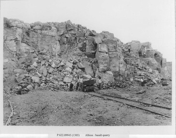 Sunshine and District Historical Society Incorporated
Photograph - Albion Quarry Photographs
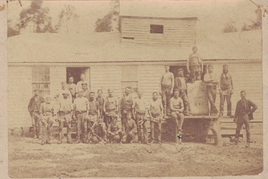
... Albion Quarry began operations in 1888, and became one of the largest bluestone quarries in Australia, later it became the Sunshine municipal tip. ...Brimbank Library, 301 Hampshire Road, Sunshine 3020. melbourne Albion Quarry began operations in 1888, and became one of the largest bluestone quarries in Australia, later it became the Sunshine municipal tip. ...Albion Quarry began operations in 1888, and became one of the largest bluestone quarries in Australia, later it became the Sunshine municipal tip. In 1888, quarrying first began on the site by the Wales family. The quarry extracted high quality bluestone, ideal for road construction, railway ballast, culverts, bridges and public buildings and private homes. The site quickly became one of the most productive basalt quarries in the region. In 1907, the Albion Quarry Company was formed as a partnership between Alexander Wales, James Watter, Peter Rumpf, Thomas Adams, William Wright Wales and Alexander George Wales (later Sir George Wales, Lord Mayor of Melbourne) The company became the largest producer of quarry products in the Commonwealth. The quarry pit was, at one time, the largest in Australia. In January 1965, Boral acquired both Albion Quarry and Reid Quarry, merging them into Albion Reid Pty Ltd. Quarrying there continued until the late 1960s–early 1970s. After quarrying ceased, the enormous pit was used as the Sunshine municipal tip. Dumped into the hole included household waste, industrial waste, chemical waste, radioactive waste and large quantities of unknown fill. Dumping continued until 1990. In the 1990’s, a methane powered electricity plant was installed on the site, but it failed due to insufficient methane production. In 2019, the former quarry made national news due to ground contamination affecting 69 residential homes, 6 commercial properties and a community park. The site is now being reserved for the future Sunshine Energy Park and is awaiting redevelopment. This quarry is historically significant for its scale, its role in Melbourne’s infrastructure, and its later environmental legacy.These photographs document the initial phase of quarrying, featuring manual labour and transportation by horse and cart.Albion basalt quarryalbion quarry, ballarat road, albion, basalt, hulett street -
 City of Melbourne Libraries
Photograph, Bull, Hugh Jones, 1897-1993, Princes Bridge Centenary pylons under construction
... Its main design features are similar to those of Blackfriars Bridge in London (1870). The bluestones were quarried from Footscray, the Malmsbury stones were from quarries at Kyneton, and the granite from Harcourt. ...Its main design features are similar to those of Blackfriars Bridge in London (1870). The bluestones were quarried from Footscray, the Malmsbury stones were from quarries at Kyneton, and the granite from Harcourt. ...Princes Bridge Centenary pylons under construction Possibly taken from Young and Jacksons Hotel (formerly Princes Bridge Hotel) on the corner of Flinders and Swanston streets, Flinders Street Station’s clocks and main entrance dominate, along with its distinctive copper dome and decorative façade. The time on the main clock is 1.40pm, and the sign underneath, reflecting Melbourne’s upcoming Centenary reads, “We must accommodate our Centenary visitors! Citizens! Do your share by taking paying guests.” At left is the original Princes Bridge Station, today the site of Federation Square. The riverside tram terminus advertises a Café/Tobacconist/Refreshment Room selling cigars & cigarettes, fountain drinks & confectionery, and in smaller text: “Leave your boot repairs here”. Nearly everyone is dressed in dark suits, coats and hats. The footpaths are wide and there are no traffic lights. The roadway stretches towards the Shrine of Remembrance, not yet dedicated but very dominant on the skyline. Government House is clearly visible across the wide parkland that would come to be known as Kings Domain and that is an area of deep importance to the people of the Eastern Kulin. Originally, Birrarung was part of a network of swamps and lagoons linked to the course of the river. From 1896, Public Works Department engineer Carlo Catani, oversaw a new channel to straighten the river and the swamps and lagoons were filled with spoil from the channel works. From the same vantage point today, only the top of the tower of Government House would be visible. The photo captures the pylons along Princes Bridge, mid-construction and being installed to mark Melbourne’s Centenary. The pylons were not without controversy. Both The Argus and The Age bemoaned them for being “made almost entirely of imported softwood timber”, denying work to native hardwood timber workers and sawmillers, and leading visitors to think Australia did not have its own exceptional native hardwoods. The pylons were also variously described in their incomplete state, as unimaginative and resembling an oilfield. Published: The Age 5 September 1934 Featured in "Newsworthy: Melbourne in photographs 1933-1936" exhibition at East Melbourne Library, October to December 2023. Exhibition caption by project volunteer, Louise McKenzie Photographer notations on slide: "Pylons + St Kilda Rd C57" Published: Age (Melbourne, Vic. : 1854 - 1954), Wednesday 5 September 1934, page 11 Published title: DECORATIONS -- THEN AND NOW. Published caption: "Although not completed yet, some impression of the effect of the decorations on Princes-bridge may be obtained from the first picture which shows the majestic sweep of St Kilda road with the Shrine of Remembrance and Government House dominating the horizon. The area to the left of St. Kilda-road and in front of Government House is portion of the area which it is proposed to call the King's Domain, which extends to Domain-road and Anderson-street..." Description: East-facing, elevated view of Flinders Street Station and Princes Bridge, featuring partially completed pylons erected for Melbourne's Centenary celebrations. The Shrine of Remembrance and Government House can be seen in the distance. In the foreground are trams, cars and trucks, pedestrians, Batman Avenue tram terminus and refreshment rooms. Signage on Flinders Street Station encourages citizens to accommodate Centenary visitors. The Melbourne Centenary was held 1934-35 in celebration John Batman's proclamation that Melbourne "the place for a village". Centenary events included a visit by Prince Henry, Duke of Gloucester. A Centenary Cake measuring 50 feet in height and ten tons in weight was cut into 250,000 pieces and sold at 1 shilling per piece for charity. Spectacular floodlighting of city landmarks, the creation of the Pioneer Women's Memorial Garden, and the MacRobertson Air Race from London, were other notable activities. Research by project volunteer, Louise McKenzie: The photo in The Age collage of 5 September 1934 has a slightly cropped foreground. The original photo has been taken from an elevated vantage point, most probably the roof of the Nicholas Building on the corner of Flinders and Swanston streets. The right foreground is dominated by the main “clocks” entrance to Flinders Street Station, showing its distinctive copper dome and decorative façade. The time on the main clock is 1.40 pm. The main sign on the front of the Station reads, "We Must Accommodate our Centenary Visitors! Citizens! Do your share by taking paying guests. Write to The Official Centenary Accommodation Bureau, 436 Collins St. City. Tel M 4671”. Another sign at eye level at the main entrance says: “Cheap Trips on Sundays”. The sign on the end of the roof along the eastern side of the station reads, “The Babies Need Your Help! Support Broadmeadows Foundling Hospital Appeal. July and August”. Run by the Sisters of St Joseph of the Sacred Heart, St Joseph’s Foundling Hospital was a purpose built infants’ home for up to 300 babies, plus accommodation for expectant mothers, mainly single women. In the early 1930s, the department (Victorian Children’s Welfare Department) contracted St Joseph’s Foundling Hospital to care for an additional 60 infant state wards, and up to 175 non wards at any given time. In 1931 it also operated a mothercraft training school. The centre foreground shows the commencement of Princes Bridge. Beneath the left side of the bridge was the site of the original Princes Bridge Station, by this time incorporated into Flinders Street Station, and today the area is the site of Federation Square. It was linked to Flinders Street station by the railway tracks that ran underneath the northern approach to the bridge. This photo shows a tram terminus which has a Café/Tobacconist/Refreshment Room, selling cigars & cigarettes, fountain drinks & confectionary, and a sign: Leave your boot repairs here. In the foreground is a wide roadway running south/north, comprising two vehicle lanes each heading north/south, and a central section containing two sets of tram tracks. There are cars, buses and delivery vans on the roadway. The trams visible are Glen Iris (Route No. 6; tram no. 448), Toorak (Route No. 8, tram no. 333), ? (No. 7), ? (No. 1), and ? (No. 2A). The footpaths are extremely wide. There is a square newspaper/magazine stand on the eastern side footpath. And also a “Ferry” sign. There are no traffic lights, but a policeman is visible on the roadway. There are pedestrians – men, women, children, a porter with trolley, women with prams. Clothing comprises dark suits, coats and hats for nearly everyone. There are double headed “Collins Street” lights along the side of the roadway, and along the northern riverbank. The roadway in the foreground is an extension of Swanston Street, which becomes Princes Bridge, then St Kilda Road, stretching towards the Shrine of Remembrance, and diverting past it. The Shrine had not yet been officially dedicated, and looks very white and dominant on the skyline. On the LHS of St Kilda Road, Government House is clearly visible across the wide parkland to be known as Kings Domain. The Kings Domain area is important to the people of the Eastern Kulin nation, and also has historical importance for its association with the early settlement of Melbourne and the foundation of British colonial administration in Victoria. On the southern side of the Yarra River (Birrarung) an historic rowing boathouse is visible, located adjacent to the Alexandra Gardens. Originally Birrarung was part of a network of swamps and lagoons linked to the course of the river. From 1896, under the guidance of engineer Carlo Catani* a new channel to straighten the river was created and the swamps and lagoons were filled with spoil from the channel works. The gardens were then created and completed in time for a Royal visit by the Duke of York in May 1901. The gardens are named after Alexandra of Denmark, the wife of King Edward VII. Both these areas, plus the Royal Botanic Gardens Victoria, Shrine of Remembrance Reserve, Sidney Myer Music Bowl, Government House, and the Queen Victoria Gardens together form the Domain Parklands. The extent of the subsequent plantings is evident today, where from the same vantage point only the top of the tower of Government House would be visible. *Catani was born in Florence in 1852, but after arriving in Melbourne worked as a civil engineer for the Victorian Government. His last major project was the reclamation of the foreshore of St Kilda, envisaged in the style of a European resort, complete with a split level esplanade, bathing pavilions, dance halls, amusements and a French-Italian style of landscape complete with palms. The gardens at the end of Fitzroy Street, St Kilda, now bear his name. The historic boathouse visible across the Yarra is another glimpse into Melbourne’s past. “Boathouse Row” comprises 7 amateur rowing clubs, the first established in 1859 (Melbourne University Boat Club). Other Clubs were Richmond, Melbourne, Banks, Melbourne Grammar School, Yarra Yarra and Mercantile. South of the river and west of the bridge is an area today developed into the Melbourne arts precinct of Hamer Hall and the Arts Centre. But at this time it was the home of Wirths Olympia Circus, which comprised Wirths Pleasure Park (an amusement park), a 5,000 seat auditorium – Hippodrome, a roller skating rink, a glaciarium, a cinema, and the Green Mill Dance Hall. Dog shows were also held at Olympia. The Green Mill Dance Hall closed in 1950, and the remainder of the Wirth buildings on site were destroyed by fire in December 1953. The feature of the photo is the pylons erected along Princes Bridge to mark Melbourne’s Centenary in 1934. The sixteen plastered pylons were designed by Roy Prentice, the second person to qualify as an architect at The University of Melbourne’s Bachelor of Architecture degree, in 1933, aged 27. Simon Reeves in his article marking the 100th birthday of Roy Prentice on 20 June 2006 reports that the State Electricity Commission sponsored this work, and the Argus reported that “… the pylons were “illuminated from within to give the effect of soft radiance”. Australia Home Beautiful 1 Oct 1934 reports in a very detailed and comprehensive article: The 10 taller pylons, including flagpole, were 48 ft, with a base of 8 ft. Timber-framed and faced with fibrous plaster and galvanised sheet iron, each structure was securely bolted to a concrete foundation three feet in depth. Panels of glass let into the shaft of each pylon were indirectly lit by 40, 100 watt lamps, and the upper bank of internal lamps were dyed so as to flood the panels with a deep red light. The decorative painted shields and flagpoles/pennants were illuminated by three 200 watt projectors concealed in the roof of each pylon, and were part of an electric night light decoration scheme involving 28 miles of wire to supply more than 20,000 lights. An article in the Argus on 18 October 1934 provided minute detail of the lighting erected in Melbourne for the Centenary, converting it “… into a coloured fairyland by night.” The estimated cost of 10 pounds per hour the lights were on. The display included 800 standard light poles 30 feet high which were tiered with electric bulbs concealed in inverted cones, 138 specially designed “Venetian poles” draped in flags trophies and streamers. The streets included in the electric night light decoration scheme were Bourke Street from Spring to William, the entire length of Collins Street, Flinders Street from Elizabeth to Spring, Lonsdale Street from Elizabeth to Swanston, Swanston and Elizabeth Streets from Flinders to Lonsdale, and parts of Springs and Spencer Streets. Together with the Princes Bridge pylons, approximately 28 miles of wire was required to supply power to the more than 20,000 lights. And that is just in the city of Melbourne. It was estimated the same amount of lighting was duplicated among other local councils. The pylons were not without controversy. The Argus on 28 August 1934 in an article headed “Imported Timber in Pylons” reported that the Princes Bridge pylons are “made almost entirely of imported softwood timber”, and have therefore denied work to native hardwood timber workers and sawmillers. The same day the Melbourne Age ran a similar story, bemoaning the fact that foreign oregon had been used which may lead tourists to think Australia did not have its own exceptional native hardwoods. A Camberwell City Councillor described the pylons as unimaginative, and the Herald reported that skeletons of pylons for the Centenary decorations in their present form led the area to resemble an oilfield! The Yarra River and Princes Bridge have long been a focal point of Melbourne life. In the early days of European settlement in Melbourne a rope-hauled punt carried people across the Yarra River. A surge in population and increased shipping traffic created a need for a bridge. There was difficulty in agreeing on a suitable site for the bridge (options were crossing at Elizabeth, Swanston, Queen or Market Streets), but the NSW Government favoured Swanston Street and the Melbourne Town Council decided on a temporary bridge across the Yarra spanning from the foot of Swanston Street. This first bridge was a single span timber toll bridge designed by Scottish born bridge designer David Lennox, and completed in 1845. It was 120 feet long, had a roadway of 17 feet wide, and a footpath on one side of 4 feet. It was leased to the Melbourne Bridge Company in the name of Robert A Balbirnie. The tollhouse was on the north side of the river and the toll keeper, Patrick Doherty, was credited with saving nine lives during the four years he was in charge of the toll station. The second bridge was stone (completed 1850), and named Prince’s Bridge after the HRH Prince of Wales, later Edward VII. It was designed with an elliptical single arc and an exceedingly small rise in proportion to the span. However, this design created an obstacle for flood waters, and together with Melbourne’s increasing population it was quickly apparent that a new bridge was required. At its opening on 15 November 1850 coincided with the imminent declaration of Victoria as a separate colony, it provided a moment of great celebration for Melbournians and “The opening ceremony was described as the grandest processional display witnessed in the colony.” (ToMelbourne.com.au) Princes Bridge in its present form, as depicted in this photograph, was designed by Jenkins, D’Ebro and Grainger, and constructed in 1886-88 by David Munro. John Grainger (father of Australian composer Percy Grainger) did the majority of the design work for the bridge. The structure was to have three arches each 96 feet wide measured across the river, and the banks on both sides were raised to allow more space for floodwater to flow. St Kilda Road was originally many feet below the current level. The bridge is of architectural significance for its substantial size, giant half columns, extensive use of wrought and cast iron, decorative elements (cast-iron lamps) and the skilled stonemasonry in the construction of the abutments and piers. Its main design features are similar to those of Blackfriars Bridge in London (1870). The bluestones were quarried from Footscray, the Malmsbury stones were from quarries at Kyneton, and the granite from Harcourt. The cost was met by the State of Victoria, City of Melbourne, and six out of seven of its municipalities, and their coats of arms feature on the bridge. The building of the bridge reflected the boom period of Melbourne, including the Victorian gold rush 1851- late 1860s, and its contractor, David Munro, was also responsible for the construction of Queens Bridge and Sandridge Railway Bridge. The Centenary pylons are no longer in place, but today this intersection still plays a major part in Melbourne’s daily life: people still meet “under the clocks” at Flinders Street station, and the route in and out of the city along St Kilda Road is often a feature of parades such as Moomba, the Grand Final Parade, and of course the Anzac Day Parade which commences at the Princes Bridge intersection and finishes at the Shrine of Remembrance. There are many tram routes, which cross the Bridge, and it directs pedestrians towards the Arts Precinct, the various components of Domain Park, plus the Southbank restaurant and rowing precincts. Even though this is a street scene, it feels very intimate; the viewer is instantly immersed in the activity of a Melbourne afternoon, looking down St Kilda Road from a viewpoint near today’s Federation Square. References: DECORATIONS -- THEN AND NOW. (1934, September 5). The Age (Melbourne, Vic. : 1854 - 1954), p. 11. Retrieved September 21, 2023, from http://nla.gov.au/nla.news-article205880269 'Flinders Street railway station', Wikipedia, https://en.wikipedia.org/wiki/Flinders_Street_railway_station 'St Joseph’s Foundling Hospital (1901-75)', Finding Records, Department of Health and Human Services, State of Victoria, https://www.findingrecords.dhhs.vic.gov.au/collectionresultspage/St-JosephsFoundling-Hospital-Babies-Home#departmental-administration 'Alexandra Gardens', City of Melbourne, https://www.melbourne.vic.gov.au/community/parks-open-spaces/major-parks-gardens/Pages/alexandra-gardens.aspx 'Wirths Circus', Wikipedia, https://en.wikipedia.org/wiki/Wirth's_Circus 'Roy Prentice: Centenary Architect', Built Heritage Pty Ltd, Simon Reeves, https://www.builtheritage.com.au/downloads/prentice.pdf 'Princes Bridge', Heritage Council Victoria, https://vhd.heritagecouncil.vic.gov.au/places/817 PORT PHILLIP. (1846, April 1). The Sydney Morning Herald (NSW : 1842 - 1954), p. 3. Retrieved September 21, 2023, from http://nla.gov.au/nla.news-article12886251 'Edward VII', Wikipedia, https://en.wikipedia.org/wiki/Edward_VII 'Princes Bridge', ToMelbourne.com, https://tomelbourne.com.au/princes-bridge/ 'Princes Bridge', eMelbourne, https://www.emelbourne.net.au/biogs/EM01189b.htm 'Princes Bridge', Australia for everyone, http://australiaforeveryone.com.au/files/melbourne/princes-bridge.html 'Victorian gold rush', Wikipedia, https://en.wikipedia.org/wiki/Victorian_gold_rush IMPORTED TIMBER IN PYLONS (1934, August 28). The Argus (Melbourne, Vic. : 1848 - 1957), p. 9. Retrieved September 21, 2023, from http://nla.gov.au/nla.news-article10952507 Princes-Bridge Pylons. (1934, August 28). The Age (Melbourne, Vic. : 1854 - 1954), p. 7. Retrieved September 21, 2023, from http://nla.gov.au/nla.news-article205532235 Pylons Appear Near Princes Bridge (1934, August 18). The Herald (Melbourne, Vic. : 1861 - 1954), p. 1. Retrieved September 21, 2023, from http://nla.gov.au/nla.news-article243104375 PRINCES-BRIDGE PYLONS. (1934, September 20). The Age (Melbourne, Vic. : 1854 - 1954), p. 10. Retrieved September 21, 2023, from http://nla.gov.au/nla.news-article205873535 28 Miles of Wire (1934, October 18). The Argus (Melbourne, Vic. : 1848 - 1957), p. 1 (The Junior Argus). Retrieved September 21, 2023, from http://nla.gov.au/nla.news-article10977836 'Historical references for Boathouse Row, Melbourne', http://boathouserowmelbourne.com.au/history/ 'ITALIAN DELEGATION TO HONOUR CARLO CATANI, DESIGNER OF THE ST KILDA FORESHORE, St Kilda Historical Society, 2001, https://web.archive.org/web/20070928061938/http://www.skhs.org.au/~SKHSarticles/articles/Carlo_Catani.html# HISTORY IN LIGHTS (1934, July 12). The Herald (Melbourne, Vic. : 1861 - 1954), p. 16. Retrieved September 21, 2023, from http://nla.gov.au/nla.news-article243172436 'Dressing Melbourne for the Duke', The Australian home beautiful: a journal for the home builder. Vol 12 No. 10 (1 October 1934), page 21, 58. Retrieved September 14, 2023, from http://nla.gov.au/nla.obj-2950922209Photographer notations on slide: "Pylons + St Kilda Rd C57".centenaries, bridges, lighting, flinders street railway station -
 Mortlake and District Historical Society
Mt. Shadwell Bush Inn, photograph
... quarry. It did a great trade after if first became licensed ub 1855, when it provided a valuable service to the travelling public and to the increasing agricultural population of the area. At that time it contained three sitting rooms, several large reception rooms, fourteen bedrooms, a bar and two taprooms and was the first known hostelry in Mortlake. In 1863 a bluestone...quarry. It did a great trade after if first became licensed ub 1855, when it provided a valuable service to the travelling public and to the increasing agricultural population of the area. At that time it contained three sitting rooms, several large reception rooms, fourteen bedrooms, a bar and two taprooms and was the first known hostelry in Mortlake. In 1863 a bluestone ...This Mount Shadwell Bush Inn erected in 1854 was situated adjacent to one of the main routes to the diggings (Great Western Road), and was originally built from tufa stone obtained from a local quarry. It did a great trade after if first became licensed ub 1855, when it provided a valuable service to the travelling public and to the increasing agricultural population of the area. At that time it contained three sitting rooms, several large reception rooms, fourteen bedrooms, a bar and two taprooms and was the first known hostelry in Mortlake. In 1863 a bluestone addition (probably done by local architect Andrew Kerr) increased the size of the hotel to 23 rooms with a detached billiard room and ballroom, kitchen, servant's apartments, laundry, storeroom, 12 stalled stable, out office, and stock yards for travelling cattle. The present hotel with its 1928 rendered facade, has had an almost uninterrupted licence since 1855 -
 Flagstaff Hill Maritime Museum and Village
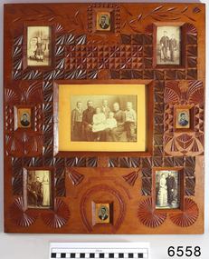
Photograph - Portraits, c. 1904
... quarry beside their father. In 1890 Ellis Dale married Ann Lees. Ann had lived nearby at Wangoom with her parents, Lees and Sarah Lees, who had had her photograph taken when she was a little girl, wearing her black dress. Ellis built a bluestone...quarry beside their father. In 1890 Ellis Dale married Ann Lees. Ann had lived nearby at Wangoom with her parents, Lees and Sarah Lees, who had had her photograph taken when she was a little girl, wearing her black dress. Ellis built a bluestone ...Ann Dale (nee Lees) was given this frame by her younger brother Thomas Chamberlain Lees, who was eighteen at that time. Thomas was the youngest son and seventh child of Lees and Sarah (nee Chamberlain) Lees. Ann loved her little brother’s artistic talents, which are demonstrated in this frame he designed and carefully carved for her. Thomas had cleverly finished the back with timber pieces around the images, and a section of a 1904 calendar. His “GOOD LUCK” is below the image of Ann, her husband Ellis Dale and their five children, c 1900. Sadly, Thomas died in 1911, aged 25. Ellis Dale’s father, William, was a quarryman who sailed from Yorkshire to Australia in 1852. He later bought land for Dale’s Quarries on the edge of Warrnambool in the area of Dale and Aberline roads. From the age of about eleven, Ellis and his brother worked in the quarry beside their father. In 1890 Ellis Dale married Ann Lees. Ann had lived nearby at Wangoom with her parents, Lees and Sarah Lees, who had had her photograph taken when she was a little girl, wearing her black dress. Ellis built a bluestone cottage for himself and Ann on his father’s land in Dales Road. He later added weatherboard rooms, and they named their finished home “Latrigg”. Early in their marriage Ellis recycled some empty dynamite boxes from their quarry to build a cupboard with drawers for Ann’s flat irons and other ironing equipment. The cupboard was used by future generations until recently, when Ann’s granddaughter, Betty Stone, donated it as part of the Chamberlain Dale Lees Collection. It is now in the kitchen of the Port Medical Office. Chamberlain Dale Lees family – local Colonial Pioneers Centre: Ellis Dale and Ann (nee Lees) and their five children - c 1900. Sons lvor William, Robert Ellis, Alfred John, and daughters - Elsie Mary Dale, and Daisy Elvena Dale. Top Left: Ann Lees - c 1868, (the little girl in the black dress) Top Right: William Dale Jnr. and Ellis Dale - c 1871 Lower Left: Ellis Dale and Ann (nee Lees), married 22 Jan. 1890 Lower Right: William Dale Jnr. and Agnes (nee Gillies), married 1883 Oval Photographs: unidentified but presumed to be family members [NB Spelling of Ann Dale – The spelling of Ann’s name has been confirmed by Betty Stone as being “Ann” (Not Anne), by phone conversation with Flagstaff Hill Maritime Village, K P 14th April 2014] (Note: For additional information please refer to Betty Stone’s book “Pioneers and Places - A History of three Warrnambool Pioneering Families” ie. Chamberlain, Dale and Lees Families)This item is associated with the families of Chamberlain, Dale and Lees. These families are listed in the "Pioneers' Register" for Warrnambool Township and Shire, 1835-1900, published by A.I.G.S. Warrnambool Branch. The handmade frame is a unique example of clever craftsmanship and carving skills used by early pioneers with limited access to materials.Family photographs, nine, set into carved, solid wood frame, stained and lacquered. Carving includes leaves, flowers, a horseshoe and a ribbon with the words "GOOD LUCK" Photographs are of the Lees family of Wangoom, from the 'Chamberlain Dale Lees Collection’ Made by Thomas Lees for his sister, Ann. The little girl with black boots on is Betty Stone's grandmother. The back of the frame has a London calendar dated 1904.Words in carved ribbon "GOOD LUCK" Calendar for the year 1904flagstaff hill, warrnambool, shipwrecked coast, flagstaff hill maritime museum, maritime museum, shipwreck coast, flagstaff hill maritime village, great ocean road, chamberlain, dale, lees, stone, betty stone, warrnambool pioneers, thomas lees, wangoom, ann dale, ellis dale, flagstaff hill, warrnambool, shipwrecked coast, flagstaff hill maritime museum, maritime museum, shipwreck coast, flagstaff hill maritime village, great ocean road, chamberlain, dale, lees, stone, betty stone, warrnambool pioneers, thomas lees, wangoom, ann dale, ellis dale, thomas chamberlain lees, handmade photograph frame, carved photograph frame, dynamite -
Glenelg Shire Council Cultural Collection
Photograph - Photograph - Cape Grant Quarry, Portland, 03/08/1953
... The Cape Grant quarry supplied an inexhaustible quantity of bluestone for the building of the new Portland harbour. ...The Cape Grant quarry supplied an inexhaustible quantity of bluestone for the building of the new Portland harbour. ...Port of Portland Authority Archives. From the Port of Portland website: Just 6km south of Portland, the Cape Grant Quarry is located on the eastern cliff of Cape Sir William Grant. This cape represents the core of a volcanic complex between two collapse calderas which underlie Nelson and Grant Bays to the west and east respectively. The Cape Grant quarry supplied an inexhaustible quantity of bluestone for the building of the new Portland harbour. The first stone was tipped at the root of the main breakwater on 17 November 1952. A small band of interested citizens were there to see the historic event. In the building, the breakwater was consolidated by the heavy traffic of Euclid’s and bulldozers and was further solidified by several storms that swept over it. Nowadays, blasting at the quarry is heavily regulated and carried out under the instructions of a qualified “powder monkey.” The days of seeing large explosions, along with the deep long loud BOOM are long gone with techniques of controlled blasting now improving overall environmental and safety standards.Front: Back- Purple PHT Stampport of portland archives, cape grant quarry, harbour development, construction -
Federation University Historical Collection
Book, Historic Sites Survey: North Central Study Area, 1979, 1979
... quarry...harcourt granite...taradale railway viaduct...loddon united waterworks trust...gouldburn weir...carisbrook lock-up...history of tree planting in streets...history of public reserves...r.u. nicholls nurseryman...thomas lang...francis moss...ballarat botanical gardens...ballarat school of mines botanical gardens...lake wendouree...victoria park, ballarat...muont holled smith...ballaarat old cemetery planting...eastern oval...ballarat east botanical gardens...ballarat east town hall gardens...eureka stockade reserve...ballarat observatory plantings...yarrowee creek plantings...yarrowee bluestone...Barker Library (top floor) Mount Helen goldfields The North Central Study Area included the Shires of Avoca, Bet Bet, east Loddon, Goulburn, Untly, Kara Kara, Korong, Maldon, Marong, Metcalfe, McIvor, Newstead, Strathfieldsaye, Stawell, Talbot, Clunes, Tullaroop and Waranga. castlemaine mount alexander goldfield maldon percydale warrenmang moliagul tarnagulla stuart mill the whipstick whroo rushworth graytown ironbark forest st arnoaud new bendigo landsborough inglewood kurting wedderburn wehla kooroora langham flat mcintyre rheola diamond hill fosterville coliban water works green gully newstead muckleford forest costerfield graytown bailieston waranga irrigaiton system eucalyptus distillery mia mia bridge korokubeal township researce concegella slate quarry chewton fryerstown kingower timor talbot majorca carisbroook clunes st arnaud taradale icomos dunolly limestone castlemaine slate quarry harcourt granite taradale railway viaduct loddon united waterworks trust gouldburn weir carisbrook lock-up history of tree planting in streets history of public reserves r.u. nicholls nurseryman thomas lang francis moss ballarat botanical gardens ballarat school of mines botanical gardens lake wendouree victoria park, ballarat muont holled smith ballaarat old cemetery planting eastern oval ballarat east botanical gardens ballarat east town hall gardens eureka stockade reserve ballarat observatory plantings yarrowee creek plantings yarrowee bluestone channels ballarat woollen mill band and albion mullock heap black hill plantings yarrowee creek channels canadian creek channel specimen vale channel poverty point reserve union jack reserve buninyong imperial mine, buninyong victoria street plantings bridge mall sturt street gardens ballarat avenue of honour plantings white flat oval plantings camp street elms burnt creek 153 page book with white plastic binding. ...The North Central Study Area included the Shires of Avoca, Bet Bet, east Loddon, Goulburn, Untly, Kara Kara, Korong, Maldon, Marong, Metcalfe, McIvor, Newstead, Strathfieldsaye, Stawell, Talbot, Clunes, Tullaroop and Waranga. 153 page book with white plastic binding. It is an historic sites survey for the North Central Study Area commissioned by the Land Conservation Council, the Ministry for COnservation and the Australian Heritage Commission. castlemaine, mount alexander goldfield, maldon, percydale, warrenmang, moliagul, tarnagulla, stuart mill, the whipstick, whroo, rushworth, graytown ironbark forest, st arnoaud, new bendigo, landsborough, inglewood, kurting, wedderburn, wehla, kooroora, langham flat, mcintyre, rheola, diamond hill, fosterville, coliban water works, green gully, newstead, muckleford forest, costerfield, graytown, bailieston, waranga irrigaiton system, eucalyptus distillery, mia mia bridge, korokubeal township researce, concegella slate quarry, chewton, fryerstown, kingower, timor, talbot, majorca, carisbroook, clunes, st arnaud, taradale, icomos, dunolly, limestone, castlemaine slate quarry, harcourt granite, taradale railway viaduct, loddon united waterworks trust, gouldburn weir, carisbrook lock-up, history of tree planting in streets, history of public reserves, r.u. nicholls nurseryman, thomas lang, francis moss, ballarat botanical gardens, ballarat school of mines botanical gardens, lake wendouree, victoria park, ballarat, muont holled smith, ballaarat old cemetery planting, eastern oval, ballarat east botanical gardens, ballarat east town hall gardens, eureka stockade reserve, ballarat observatory plantings, yarrowee creek plantings, yarrowee bluestone channels, ballarat woollen mill, band and albion mullock heap, black hill plantings, yarrowee creek channels, canadian creek channel, specimen vale channel, poverty point reserve, union jack reserve buninyong, imperial mine, buninyong, victoria street plantings, bridge mall, sturt street gardens, ballarat avenue of honour plantings, white flat oval plantings, camp street, elms, burnt creek -
 Sunshine and District Historical Society Incorporated
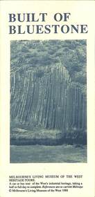
Pamphlet - Built On Bluestone, Melbourne's Living Museum of the West, 1988
... Quarry Built On Bluestone Folded A3 tour information pamphlet giving the background to the use of bluestone and lists significant properties that have been built from bluestone including a touring map Pamphlet Built On Bluestone Melbourne's Living Museum of the West ...Built On Bluestonequarry -
 Hume City Civic Collection
Photograph, Early 1970s
... The Kaolin Quarry at Bulla supplied Kaolin to the Northcote and Brunswick Pottery Works until it ceased operation at that site in the 1950s. The three arched bluestone...A black and white photograph of the Deep Creek and three arched bluestone bridge in the Bulla Township with the Kaolin Quarry in the background. ...Hume City Civic Collection 44 Macedon Street Sunbury melbourne The Kaolin Quarry at Bulla supplied Kaolin to the Northcote and Brunswick Pottery Works until it ceased operation at that site in the 1950s. The three arched bluestone ...The Kaolin Quarry at Bulla supplied Kaolin to the Northcote and Brunswick Pottery Works until it ceased operation at that site in the 1950s. The three arched bluestone bridge r3placed a ford crossing across Deep Creek, which along with Jacksons Creek flows into the Maribyrnong River.A black and white photograph of the Deep Creek and three arched bluestone bridge in the Bulla Township with the Kaolin Quarry in the background. One truck is crossing the bridge with a tanker approaching the bridge at the bottom of the Bulla Hill.deep creek, bridges, kaolin quarries, quarries, george evans collection -
 Uniting Church Archives - Synod of Victoria
Postcard, undated
... bluestone building in the Gothic style and was designed by the Ballarat architect J.A. Doane. Construction began in 1864 and the church was further extended in 1871. The building consists of a broad nave and transepts with galleries, these having cast iron balustrades. The facade incorporates a slate-roofed octagonal turret and spire and a four-light perpendicular Gothic window. The interior includes windows with quarry...bluestone building in the Gothic style and was designed by the Ballarat architect J.A. Doane. Construction began in 1864 and the church was further extended in 1871. The building consists of a broad nave and transepts with galleries, these having cast iron balustrades. The facade incorporates a slate-roofed octagonal turret and spire and a four-light perpendicular Gothic window. The interior includes windows with quarry ...The Wesleyan Methodist Church at Clunes is a distinctive bluestone building in the Gothic style and was designed by the Ballarat architect J.A. Doane. Construction began in 1864 and the church was further extended in 1871. The building consists of a broad nave and transepts with galleries, these having cast iron balustrades. The facade incorporates a slate-roofed octagonal turret and spire and a four-light perpendicular Gothic window. The interior includes windows with quarry glass panes and coloured borders; those on either side of the organ incorporate scrolled texts and may be by the Melbourne makers Ferguson & Urie. With declining congregations, the property was purchased by Wesley College in 1999 and now forms part of its Clunes campus. The church building has received a very extensive restoration, including structural strengthening, the opening out of the interior to its original dimensions and the installation of a new floor. Ref: https://www.ohta.org.au/organs/organs/ClunesUC.html Colour postcard showing a street view of the Clunes Methodist Church,clunes wesleyan methodist church, wesley college