Showing 31 items matching " bluestone structures"
-
 Streatham and District Historical Society
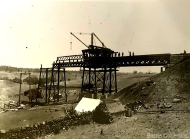
Picture, Jack Balkin & Barney Meek, 1927
... bluestone...structures...Shows the typical dress at the time of the picture and the transport at the time. horse jack children hotel streatham barney meek balkin bluestone structures :Barney Meek & Jack Balkin: Desma Meek, 1927. ...This picture shows the clothing worn of the time of the photo, these would be typical for this time. Demonstrates forms of transport at the stage of the photo. The building is the barn at the local Streatham Hotel and demontrates the building structure and materials. Barney Meek & Jack Balkin were local children.Shows the typical dress at the time of the picture and the transport at the time.Rectangular, Black & white. Two children sitting on a horse infront of a bluestone building. Both children wearing shorts and jumpers. There is someone holding the horses bit and shadows on the ground.:Barney Meek & Jack Balkin: Desma Meek, 1927.horse, jack, children, hotel, streatham, barney, meek, balkin, bluestone, structures -
 Glen Eira Historical Society
Letter - Rosstown Railway
... ... Bluestone Structures...Office Workers CAULFIELD CONTACT Norman Peter Groups Glen Huntly Koornang Road Mills Sugar Mills Caulfield Historical Society Caulfield City Council Caulfield Town Hall Official Buildings Glen Huntly Neville Street Fourteen Parliamentary Representatives Rosstown Rosstown Railway Rosstown Railway Centenary Festivals and Celebrations Centenaries Historical Markers Plaques Monuments and Memorials Ross Murray Railways Land Transport Curraweena Road Parts of Buildings or Structures Bluestone Structures Construction Materials Caulfield Community Liaison Officer Harry Carol Currency Finances Onley Peter Elsternwick Oakleigh Council Meetings Caulfield Council Chambers Caulfield Municipal Chambers Caulfield Municipal Offices Craig A. ...This file contains two items: 1/A group of eight letters, predominantly between Hon. Secretary of Caulfield Historical Society R. Ballantyne and members of the Caulfield City Council written between 1981 and 1983, regarding the installation of a plaque in commemoration of the centenary of the Rosstown Railway. The first two letters are handwritten from R. Ballantyne to G. Calder and Carol Camy, dated 01/06/1981 and 22/02/1982. The letter to G. Calder supports a suggestion in the May edition of the CAULFIELD CONTACT for the installation of a plaque in celebration of the centenary of the Rosstown Railway, suggesting a potential site for another plaque on Curraweena Road. The letter to Carol Harry discusses the costing of the plague and a possible contribution towards this cost from the Caulfield Historical Society. The letter appears to be incomplete, having no sign off from the author. Attached to the letter is what appears to be a suggestion for the inscription of the plaque. The letters addressed to R. Ballantyne are typed and dated 12/06/1981, 24/06/1981, 14/07/19891, 17/12/1981 and 08/09/1983, from A. Craig and D.B. Hogan on behalf of City Manager G.K. Calder and City Liason Officer Carol Harry. All letters concern the commemorative plaque, with these from Carol Harry including handwritten notes which appear to be in R. Ballantyne’s handwriting. The final letter is from Mayoral Secretary Norma Polglase to Miss B. Snowball, dated 23/08/1983, inviting her to attend the unveiling of the plaque. Also included in the item are Council Committee Meeting minutes, dated 16/05/1981, broaching the subject of installing the plaque in Koornang Road. 2/Four colour photographs and two black and white copies of one of the photographs, all dated 18/09/1983 and showing the opening of the commemorative plaque in Marrara Gardens. Two photographs picture Mayor Brian Rudski and City Manager Graham Calder with a crowd of unidentified people present. One photograph and both copies are of the inscription on the plaque, with the wording identical to that of the handwritten note by R. Ballantyne, in item one.caulfield, caulfield south, calder g.k., calder g., hawthorn road, glen eira road, ballantyne r., office workers, caulfield contact, norman peter, groups, glen huntly, koornang road, mills, sugar mills, caulfield historical society, caulfield city council, caulfield town hall, official buildings, glen huntly neville street fourteen, parliamentary representatives, rosstown, rosstown railway, rosstown railway centenary, festivals and celebrations, centenaries, historical markers, plaques, monuments and memorials, ross murray, railways, land transport, curraweena road, parts of buildings or structures, bluestone structures, construction materials, caulfield community liaison officer, harry carol, currency, finances, onley peter, elsternwick, oakleigh, council meetings, caulfield council chambers, caulfield municipal chambers, caulfield municipal offices, craig a., caulfield city manager, city of caulfield, caulfield physical environment committee, public meetings, meetings, ross james, hogan o.b., arrow engraving, campbell f., snowball miss., elsternwick gladstone parade nineteen, walters w.r., marara road gardens, marara road, marara gardens, narrawong road, ceremonies, caulfield mayors, polglase norma, mayoral secretaries, railways routes, documents, correspondence, rudski brian, calder graham, events and activities, official buildings, insignia, local government, local officials and employees, parks and reserves, buildings structures and establishments, official events, festivals and celebrations, occupations, political processes, local history, history, financial economics, local government finance -
 Hume City Civic Collection
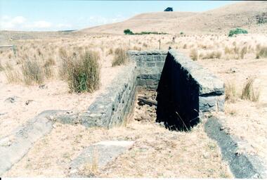
Photograph, Early 1990's
... These ruins are found in varying degrees of structural damage caused by erosion, vegetation growth and vandalism. The bluestone structure was a sheep dip on the 'Karoora Park' property near Jacksons Creek....These ruins are found in varying degrees of structural damage caused by erosion, vegetation growth and vandalism. The bluestone structure was a sheep dip on the 'Karoora Park' property near Jacksons Creek. stone structures sheep dips basalt rock 'karoora park' george evans collection A coloured photograph of the stone remains of a sheep dip constructed from basalt rock. ...This is a photograph of one of the many stone ruins which can be seen in the Sunbury area and surrounding districts. These ruins are found in varying degrees of structural damage caused by erosion, vegetation growth and vandalism. The bluestone structure was a sheep dip on the 'Karoora Park' property near Jacksons Creek.A coloured photograph of the stone remains of a sheep dip constructed from basalt rock. The ground at the entrance slopes down into a narrow walled channel. The surrounding paddocks are covered with tussocks of grass and there are bare hills in the background. The grass is brown.stone structures, sheep dips, basalt rock, 'karoora park', george evans collection -
 Bendigo Historical Society Inc.
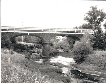
Photograph - BENDIGO HISTORICAL SOCIETY COLLECTION: REDESDALE BRIDGE
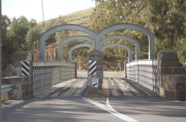
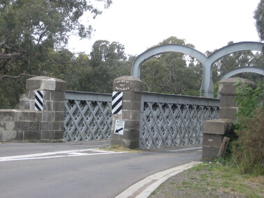
... The Redesdale Bridge is a wrought iron and timber structure with bluestone abutments, located over the Campaspe River near the town of Redesdale. ...The Redesdale Bridge is a wrought iron and timber structure with bluestone abutments, located over the Campaspe River near the town of Redesdale. ...Colour photograph of the Redesdale bridge over the Campaspe River at Redesdale. The Redesdale Bridge is one of the oldest iron lattice-truss bridges in Victoria, Australia. The Redesdale Bridge is a wrought iron and timber structure with bluestone abutments, located over the Campaspe River near the town of Redesdale. Image taken from Redesdale side of bridge showing two lane design. Plaque on bridge in centre of divided road reads ' Shire of Metcalfe'. Photo taken during a BHS tour, possibly 1990's.bridge, redesdale -
 Ballarat Heritage Services
Photograph, Redesdale Bridge, 2016, 18/01/2016
... The Redesdale Bridge is a wrought iron and timber structure with bluestone abutments which was installed over the Campaspe River in January 1868, although the bridge actually bears the date 1867. ...Ballarat Heritage Services PO Box 2209 Bakery Hill Post Office goldfields The Redesdale Bridge is a wrought iron and timber structure with bluestone abutments which was installed over the Campaspe River in January 1868, although the bridge actually bears the date 1867. ...The Redesdale Bridge is a wrought iron and timber structure with bluestone abutments which was installed over the Campaspe River in January 1868, although the bridge actually bears the date 1867. In 1859, the "Herald of the Morning", a ship carrying a cargo including 350 tons of ironwork for the Hawthorn bridge, caught fire and was scuttled a quarter of a mile off the jetty at Sandridge. A Melbourne salvaging firm raised the ironwork from the bottom of the bay, but after details of an arranged sale to the government caused a scandal in Parliament, the material was sold privately to the Melbourne foundry Langlands & Co. Two hundred tons of it was sold to the goldfields shires of McIvor and Metcalfe for only £1000. The bridge was designed by engineer T.B. Muntz and built by a contractor named Doran, and was completed late and considerably over budget at £6274. The bridge spans 45.7m across the river and has two roadways which are carried between three metal lattice girders in a through truss configuration. The design for the Hawthorn bridge had the deck supported over the trusses, and to stiffen the through truss configuration three sets of distinctive paired arches connect the trusses above the roadways. The roadway decking is constructed of longitudinally placed timbers on timber cross girders which rest on the lower chords of the trusses. (Heritage Victoria) A number of colour photographs showing the historic bridge at Metcalfe.metcalfe, shire of metcalfe, bridge, municipal boundary, shire of mcivor, redesdale bridge, campaspe river, t.b. muntz, doran -
 Melton City Libraries
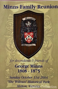
Document, Minns Family Reunion, 2004
... It was envisaged that the farmhouse would form ‘a picturesque centrepiece to Melton’s planned … historical park, along with Dunvegan bluestone cottage … and similar structures as they become available.’ ...It was envisaged that the farmhouse would form ‘a picturesque centrepiece to Melton’s planned … historical park, along with Dunvegan bluestone cottage … and similar structures as they become available.’ ..."A perpetual spring in the adjacent creek provided a steady supply of fresh water to the site on which the homestead is built. Although we can not be certain of the identity of the builder, the first stage of ‘The Willows’ homestead appears to have been constructed in the mid 1850s. The house is situated on Crown Allotment No.1 (No Section), Parish of Kororoit, an allotment of 5 acres 3 roods 4 perches. Although it had surveyed the land, the Crown did not offer it for sale until 22nd November 1861, at which time it was purchased by Charles March Williams. (Although the property is directly opposite and immediately adjacent to the Township of Melton, and was sold as ‘Suburban Allotment 33’, it was situated within the Shire of Braybrook rather than the Shire of Melton until 1917.) Considerable improvements had taken place on the land prior to the Crown sale. When CM Williams purchased the allotment in November 1861 he paid £23.5.0 for the land itself, and valued the improvements at £400. Even allowing for some exaggeration by Williams, this is an extremely high valuation for improvements, and must have included a house. Some local research has claimed that in 1858 Williams had taken over the interest of a Mr Parkinson in the property, and that Parkinson built the house upon taking possession of the land c.1855. It was definitely built by 1861, when a map shows a square building on the site marked as ‘House’. The property is important in the district for its association with the establishment of the pound. The district pound had been established in 1854, when George Scarborough of Mount Cottrell (Mt Cottrell Road, south of Greigs Road) was appointed pound-keeper. Scarborough resigned in 1857. The pound was moved to Melton following agitation from local farmers and Charles March Williams appointed pound-keeper on 26th April 1858. Williams, the son of a doctor, had been born in London. Reminiscences of local residents of the time, as recorded in the Express newspaper, note Williams’ success in breeding horses on the property. Sales of up to 60 guineas were noted. Whether this was from Williams’s own stock or from unclaimed pound stock is not made clear. Williams appeared before a government inquiry in 1860 and advocated registration of all stock brands in the State. Williams died in 1862 leaving a widow, Catherine, and five living children aged 15 years to five months. At the time of his death Williams had entered negotiations with one Matthew Devenish and had a mortgage of £100 on allotments 1 and 2, Parish of Kororoit. Catherine Williams was appointed pound-keeper on 2 September 1863, with her eldest son Charles as her assistant. Her tenure was short for on 22nd March 1864 George Minns senior paid Matthew Devenish £135 for allotments 1 and 2 Parish of Kororoit (considerably less than Williams had claimed the property was worth in 1861) and on the same day paid William Tullidge £45 for the adjoining allotments 3 and 4. In April 1867, James Ebden Minns, the newly married son of George senior became the owner of The Willows property having entered into a mortgage arrangement with his father to the extent of £200. At the time George Minns was residing in Kaarimba having left Melton in 1867 for a short trip to England and upon his return having taken up a selection in the Kaarimba district with his son Frederick who had a hotel licence there. James paid out the mortgage on 2-1-1873. James Minns was appointed pound-keeper in 1872; in 1885 the pound was moved elsewhere and Minns purchased the old pound site and added it to his farm. The Willows residence underwent a major change about this time. A two room extension, similar in style but with a lower elevation was added to the original rear of the house with a chimney matching the distinctive originals. Window arrangements did not match the original but became a feature of the façade when the new addition became the front of the building. Six buttresses were attached to the east and west walls of the old building, two to the south wall and the whole rendered with mortar to give the appearance of dressed stonework around the windows. Galvanized iron was placed over the shingles and a verandah added on three sides. By 1876 The Willows was the homestead for a thriving mixed farm of 340 acres of which 156 was rented from a H. Ruck. In October of that year the Australasian travelling reporter visited and reported on the property. In common with the nearly every other property in the district the farm had ‘recently’ (generally within the last two years) abandoned cultivation of crops, and turned over completely to cattle pasture. Butter making was the principal occupation of the farm, which had about 50 head of cattle, a large proportion of which were milking cows. The reporter also noted that a ‘large number of pigs are kept upon this farm and are found to be very profitable stock’. Their manure was used in an orchard and garden in which ‘large quantities of lucerne and prairie grass are grown for the use of stock when ordinary feed is scarce’. Two bores attached to deep brick lined wells supplied water for the house in addition to the farm. A commodious timber barn and necessary sheds had also been constructed. Access to the property was improved following the construction of the bluestone ford across the creek c.1887, when the recreation ground came into use. Prior to this date it may have been that the crossing referred to as ‘Mr Minns bridge’ was used. This appears to have been a flimsy structure and has but two references in Council reports in the Melton Express in the 1880’s. It is believed that in the late 1890’s a timber building was added near the rear of the building to house a kitchen, ablutions and laundry rooms and rooms for seasonal workers. This was attached to the house by means of a trellised walkway using the original front entry to the house (long since the back door). A photograph of this building appears in a local history of Melton. This was demolished in recent decades during the period when the house was tenanted (after the Minns family had left). James Minns son, George, took over the property following his marriage to Alice Walsh in 1903. James and Caroline moved into a house on the former JH Games property at the eastern end of Henry Street. George held the position of Shire Secretary for Melton for 40 years. He was a most prominent member of the community being Secretary to, among others, the Melton Coursing Club, the Shooting Club and the Cemetery Trust. He also rode with the hunting parties who sported across the Plains and were entertained at Mount Kororoit. George and Alice had one son, Norman who followed his father into local government and became Secretary of the Shire of Werribee completing a record term in this position. George retired to Werribee in 1951, where he died in 1965. The National Trust records note that James Ebden Minns and his sons were ‘leading men of the district, Justices of the Peace, and Shire Councillors’. It claims that Sir Thomas Bent was a frequent visitor. The Willows passed into the hands of George’s grandson, Bruce Minns and the property was let for a number of years. In the 1960s it became vacant and was subject to vandalism. Major structural problems arose with the part demolition of the roof, the loss of windows and doors and holes dug into and under the floorboards. The outbuildings were particularly targeted. Following widespread public support, the Shire of Melton purchased the house, with 3.75 acres of land, in 1972. In 1975 the Shire of Melton and the Melton and District Historical Society were successful in nominating the building for National Trust classification, and then the Australian Heritage Commission’s Register of the National Estate. The AHC particularly noted its ‘townscape importance’. It was envisaged that the farmhouse would form ‘a picturesque centrepiece to Melton’s planned … historical park, along with Dunvegan bluestone cottage … and similar structures as they become available.’ In a time of great Melton’s ‘satellite city’ development the Council spelt out its broader vision in its submission to the AHC: ‘Melton is destined to become, by the end of the present century, a city of between 75,000 and 100,000 people. Significant relics of the past, such as ‘The Willows’, regrettably will be rare in that situation. It is essential that sufficient tangible links with Melton’s pioneering days remain to promote in the new community a sense of history and continuity’. Under the direction of ‘The Willows’ Restoration Committee and consultant architect John Hitch, all outbuildings, with the exception of the garage and toilet, were demolished and the dwelling house restored. Finances were provided by the Shire of Melton and the National Estate Grants Program, and considerable amount of voluntary labour was provided by the local community. The orchard was removed, and remaining wooden buildings were relocated to provide an open vista for visitors to the Park. The property was furnished with donations from district families keen to preserve this example of pioneer life in the area. The Willows became the headquarters of the Melton and District Historical Society". Invitation to the family reunion at the Willowslocal identities, pioneer families -
 Glen Eira Historical Society
Album - Album page, Hotham Street, Circa 1972
... It is aesthetically significant (Criterion E) as an intact nineteenth century structure of its type, many similar girder bridges having been renewed with concrete girders in recent years. The bluestone ...This photograph is part of the Caulfield Historical Album 1972. This album was created in approximately 1972 as part of a project by the Caulfield Historical Society to assist in identifying buildings worthy of preservation. The album is related to a Survey the Caulfield Historical Society developed in collaboration with the National Trust of Australia (Victoria) and Caulfield City Council to identify historic buildings within the City of Caulfield that warranted the protection of a National Trust Classification. Principal photographer thought to be Trevor Hart, member of Caulfield Historical Society. Most photographs were taken between 1966-1972 with a small number of photographs being older and from unknown sources. All photographs are black and white except where stated, with 386 photographs over 198 pages.Victorian Heritage Database - Hotham Street Road Overbridge HO116 Heritage Overlay - City of Glen Eira https://vhd.heritagecouncil.vic.gov.au/places/43557 (as of 04/07/2021) The Hotham Street road overbridge is located on the Sandringham railway line between Ripponlea and Elsternwick railway stations. It is presumed to have been built by contractors Sharp and Campbell who signed a contract on 25th . November, 1881 to construct a second line of railway between Windsor and Elsternwick. This contract was completed during 1882 and the bridge may have been designed in the year when Robert Watson took over from William Elsdon as engineer in chief for the Victorian railways. It is historically, aesthetically and technically significant. It is historically significant (Criterion A) to the extent that it demonstrates the standards of construction adopted by the Victorian Railways Department when it rebuilt the lines acquired from the private railway companies, (compare the Geelong and Melbourne Railway Co's line from Newport to Geelong, acquired in 1860). It is aesthetically significant (Criterion E) as an intact nineteenth century structure of its type, many similar girder bridges having been renewed with concrete girders in recent years. The bluestone abutments demonstrate high standards of stone masonry and are representative of Departmental work of the period. This bridge forms one of a group of historic structures on the railway to Brighton Beach and therefore contributes to the line's cultural importance as a whole. The survival of the riveted iron girders with their bellied angle iron struts is important since these elements are representative of the civil engineering practices of the Victorian Railways at the time and constitute the technical significance (Criterion F) of the structure.Page 96 of Photograph Album with three photographs (one portrait and two landscape) from Hotham Street - two external views of one house and a railway bridge.Handwritten: Hotham Street [top right] / 112 HOTHAM ST [under top left photo] / BRIDGE OVER SANDRINGHAM RAILWAY [under top right photo] / 112 HOTHAM ST CNR MELBY AVE [under bottom left photo] / 96 [bottom right]trevor hart, elsternwick, hotham street, caulfield, houses, brick, bay windows, verandahs, railway bridges, tunnels, gardens, bluestone, civil engineering, victorian railways, sharp and campbell, contractors -
Glen Eira Historical Society
Document - Uniting Church Archives, Orrong Road, 78-66, Elsternwick
... Architect Gothic Revival Architecture Bluestone Architectural Features McCallum Alex Monuments and Memorials Oakleigh Arthur Stained Glass Cato Methodist Ladies College Orrong Road Uniting Church Cato Parish Chapels Architects Crouch T.J. Builders Ireland and Newton Ward Norma Religious Structures ...Five documents about the history of Elsternwick Methodist Church: 1/Two copy of the Centenary History of Orrong Road Uniting Church 14 November 1887-14 November 1987 by Norma Ward. Includes a list of Ministers, supernumeries and members of the male choir. 2/Handwritten updated history by N. Ward. 3/Roneoed copy of history of church by Betty Snowball dated 1978. 4/Caulfield Conservation study by Andrew Ward dated January 1995. 5/Printed extract of minutes dated 28/10/1927, 20/01/1928, 04/04/1928 and 07/06/1928. Details include the design of windows, placement in church, cost incurred of windows, the unveiling of windows, who by and appointment of committee to solicit donations to reduce debt reduction.methodist church, orrong road, elsternwick, snowball betty, foundation stones, campbell james, sunday school, halls, organs, leadlight, cato college, crouch t.j., architect, gothic revival architecture, bluestone, architectural features, mccallum alex, monuments and memorials, oakleigh arthur, stained glass, cato methodist ladies college, orrong road uniting church, cato parish, chapels, architects, crouch t.j., builders, ireland and newton, ward norma, religious structures and establishments, point nepean road, catterall john, daniel george, cook r. osborne, williams spencer, eggleston j., symons f., clergy, johns w.t., knuckey h.m., mitchells a.h., webster n.d.l., butcher t.w., cocks w.h., arthur g.t., warren j.e., williams r., hooper r.e., allen h.f., bennett m.m., walklate c.j., elliot n., hull j.e., chadwick r.j., roberts v., johnson l., coombe m., prior family, prisk family, mclaughlin family, searls family, bartrop family, orames fred, peverill family, brown family, crave e.s., bremer family, lambert family, grimwood family, kenny joe, wilson family, furlong family, oakley r. mck., holt vera, holt thelma, towans furniture removal, bouchier miss, trevena miss, matthews g.f., whitbourn m.j., penhallbrick family, searls beat, charlesworth albert, adams percy, leather tom, crone ted, hill herb, clubs and associations, staniland grove, beck family, rogers family, phillips family, kent family, kemp family, oakley family, bowden family, whiteside jack, bond family, beddoe bob, aston family, eddy r.d., marshman family, blackie family, kerr family, crellin family, towan family, curtis family, clarks, vivian george, lansell family, carmichael family, bright family, borcher family, albury family, cole family, semmens family, symons family, crowe e.s., hill bert, ward les., marriott jack, mcdonald malcolm, frost charles, macalese jack – entertainer ventriloquist, dunnachie frank, fletcher jack, gamley doug sen., old aubrey, gregory fred, roach family, grimwood family, hill frank, hill alan, sprott norm, guard w.h. rev., wellard ralph, bower wally, dunstan bert, hill herb, proctor keith – organist, gamley doug, slate tiles, rowan street, builders, jones and co., elsternwick uniting church – st. john’s, glenhuntly road, fijian assembly of god, victorian synod of the uniting church, plaques, memorials, mcoakley r. mrs., mcoakley r. mr., pensford mr., davies f.e. mr., brooks robinson and co., eddy r.d., whitborn m.j. mrs., whitborn g.f., tarah mr., arthur w. rev., biddoe mr., davies mr., crow mr. -
 Greensborough Historical Society
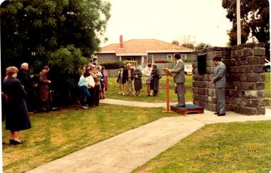
Photograph - Digital image, Dennis Ward, Bridge Plaque - Pioneer Park Greensborough, 27/03/2010
... The bluestones used in the construction of this viewing platform and in the carpark entry structure and retaining wall are from the northern arch of Greensborough's first Plenty River Bridge built in the 1860s adjacent to this site. ...The bluestones used in the construction of this viewing platform and in the carpark entry structure and retaining wall are from the northern arch of Greensborough's first Plenty River Bridge built in the 1860s adjacent to this site. ...Plaque at Pioneer Reserve Greensborough: "Shire of Diamond Valley. The bluestones used in the construction of this viewing platform and in the carpark entry structure and retaining wall are from the northern arch of Greensborough's first Plenty River Bridge built in the 1860s adjacent to this site. The centre span of the original bridge was removed in 1865 when the western half of the existing bridge was constructed leaving the northern and southern stone arches. The southern arch was retained until floods in 1874 necessitated its removal. The picnic shelter in this reserve was constructed using stone from this abutment. The northern arch was removed in 1983 when widening of the existing bridge commenced."Digital copy of colour photograph.plenty river, pioneer reserve greensborough -
 Greensborough Historical Society
Photograph - Photograph (Framed), Greensborough bridge, 1870s
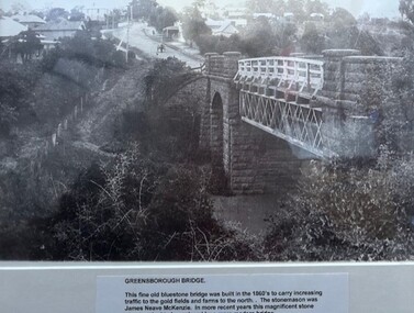
... Greensborough bridge caption reads: "This fine old bluestone bridge was built in the 1860s to carry increasing traffic to the gold fields and farms to the north. The stonemason was James Neave McKenzie. In more recent years this magnificent stone structure...Greensborough Historical Society 34A Glenauburn Road Lower Plenty Lower Plenty melbourne Greensborough bridge caption reads: "This fine old bluestone bridge was built in the 1860s to carry increasing traffic to the gold fields and farms to the north. The stonemason was James Neave McKenzie. In more recent years this magnificent stone structure ...Greensborough bridge caption reads: "This fine old bluestone bridge was built in the 1860s to carry increasing traffic to the gold fields and farms to the north. The stonemason was James Neave McKenzie. In more recent years this magnificent stone structure had to be replaced by a more modern bridge."From the John Davidson collection.Photograph in black plastic frame with typed caption on matte.john davidson, mckenzie bridge, greensborough, blue stone bridge -
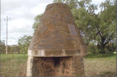 Bendigo Historical Society Inc.
Photograph - BENDIGO HISTORICAL SOCIETY COLLECTION: BURKE AND WILLS CAIRN BARNADOWN
... Colour photograph of bluestone fireplace erected at Barnadown to commemorate the camp site of the Burke and Wills expedition.The stone fireplace is a memorial to the Burke and Wills Expedition which camped near here. It was erected by the Waranga Shire Council to commemorate the centenary of the Victorian Exploring Expedition`s passage through the Barnadown district in 1860. A plaque on the structure...History House 11 Mackenzie Street Bendigo goldfields EXPLORATION Terrestrial burke and wills Colour photograph of bluestone fireplace erected at Barnadown to commemorate the camp site of the Burke and Wills expedition.The stone fireplace is a memorial to the Burke and Wills Expedition which camped near here. It was erected by the Waranga Shire Council to commemorate the centenary of the Victorian Exploring Expedition`s passage through the Barnadown district in 1860. A plaque on the structure ...Colour photograph of bluestone fireplace erected at Barnadown to commemorate the camp site of the Burke and Wills expedition.The stone fireplace is a memorial to the Burke and Wills Expedition which camped near here. It was erected by the Waranga Shire Council to commemorate the centenary of the Victorian Exploring Expedition`s passage through the Barnadown district in 1860. A plaque on the structure reads: 'Burke and Wills Centenary. The party camped near this spot on 28th August 1860 on its outward journey. Erected by the Shire of Waranga 1960'.exploration, terrestrial, burke and wills -
 Bendigo Historical Society Inc.
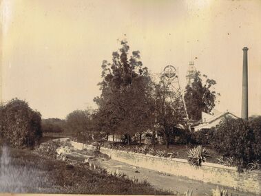
Photograph - HUSTLERS ROYAL RESERVE MINE, BENDIGO CREEK
... bluestone pitchers. On RH side Hustlers Royal Reserve Mine, chimney and poppet head visible. Poppet head has lattice girder legs. Post Office clock behind showing 25 to 4. Image is pre-1910, when mine structure...bluestone pitchers. On RH side Hustlers Royal Reserve Mine, chimney and poppet head visible. Poppet head has lattice girder legs. Post Office clock behind showing 25 to 4. Image is pre-1910, when mine structure ...Sepia image mounted on board: image shows Bendigo Creek, sandstone walls on creek. Creek is not yet paved with bluestone pitchers. On RH side Hustlers Royal Reserve Mine, chimney and poppet head visible. Poppet head has lattice girder legs. Post Office clock behind showing 25 to 4. Image is pre-1910, when mine structure was removed.bendigo, mining, hustlers royal reserve/bendigo creek, bendigo, sandhurst, bendigo creek, mining, huslters royal reserve, post office, poppet head, chimney -
 Glenelg Shire Council Cultural Collection
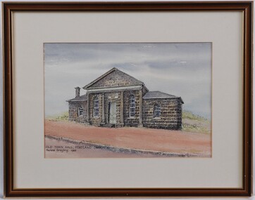
Painting - Painting - Old Town Hall Portland, Pauline Grayling, 1983
... View of bluestone building with false columns decorating front of central structure. The building is situated on the side of a road, with red sand/gravel in front and low-lying greenery behind. ...View of bluestone building with false columns decorating front of central structure. The building is situated on the side of a road, with red sand/gravel in front and low-lying greenery behind. ...View of bluestone building with false columns decorating front of central structure. The building is situated on the side of a road, with red sand/gravel in front and low-lying greenery behind. Mounted in cream matt and framed in a wooden frame.Front: Old Town Hall, Portland (1863) Pauling Grayling 1983 (Black Ink) Back: Old Town Hall/Portland - $100 (Pauline Grayling/42 Greenwood Ave/Ringwood 870 7649 (black felt tip pen on sticker, upper right). -
Federation University Historical Collection
Book, New York Post, The School of Mine Quarterly: A Journal of Applied Science, 1889-1809
... structure of the Starch Molecule...Cerrillos Hills New Mexico...geology...Rossie Lead Veins...practical electrochemistry...lines of graphic statics...Anistic Acid by the ozidation of Anniseed Oil...Bromate method for antimony...John Krom Rees...Trust company of America Building...Helion lamp...Frederick Arthur Goetze...Mine Surveying...Pine Wood Oils...Malleable Cast iron...Electrolytic treatment of Galena...turpentine and pine oils...Bluestone...Barker Library (top floor) Mount Helen goldfields The School of Mines Quarterly was a jpournal of Applied Science from Columbia College, New York City. school of mines new york columbia college schools of mines columbia school of mines Witwatersrand Goldfield INter-continental Railway Mine Ropes Harbor improvememnts on the Pacific coast Glycerine and artificial Butter industry Transit Factors for teh Columbia College Observatory Tables for the Reducation of Transit Observations Ancienct methods for dividing and Recoording time in Japan Assay of tin John Strong Newberry Standards of linnear Measure Comparison of costs of electric lighting Huanchaca Mine Bolivia El Callao Gold Mine Venezuela John Magnus Adams Ores in Saxony Hartz and Rhenish Prussia Hofmann Apparatus Adjustment of Trangulation Determination of Carbonic Acid in White Lead Lower Coals in Western Clearfield County Pennsylvania Old Telegraph Mine Ningham Canon Utah mechanical Preparation of Ores modern waterworks construction curdling of milk French regenerative gas furnace Irrication Canals peruvian salt mine Collection of Metallurgic Dust and fume Permeability of iron and steel Assay of Silver Explosion in a Zinc Fume condenser Teaching archtectural history Liquid air between the mine and the smelter Ballistic Galvonometer Assay of Telluride ores Analytical Chemistry Theory and design of the masonry arch silver pick mine Wilson colorado telegraphy and telephoney mineralogy morse code Michigan mining practices Titaniferous magnetites paradox of the pantheon Rocks from Wyoming Witwatersrand goldfields Gaseous sun Alternating current distribution Engineering tests on direct current Electrical Machinery Thomas Egleston Ore dressing Frederick Morgan Watson Camp Bird Gold Mine and Mills Magnetic properties of Iron and Steel Morphology of Organic compounds Antimony structure of the Starch Molecule Cerrillos Hills New Mexico geology Rossie Lead Veins practical electrochemistry lines of graphic statics Anistic Acid by the ozidation of Anniseed Oil Bromate method for antimony John Krom Rees Trust company of America Building Helion lamp Frederick Arthur Goetze Mine Surveying Pine Wood Oils Malleable Cast iron Electrolytic treatment of Galena turpentine and pine oils Bluestone Ashokan Dam bluestone road resistances Oxy-gas blowtorch Mine dumps segregation of steel ingots masonry dam formulas putnam county magnetic belts gases Continuity of education Hydraulic diagrams standardistion of Potassium permanganate Sewerage Discharge into Sea Water Modern waterworks True Column formula Slags from lead furnaces missouri river tempreture of gases rocks architectural history Modern dome oil machine undulations in railway tracks Irrigation engineering Cleps-tachymeters Electrical Engineering New York Shales fan pump Sucrose Isaac Newton French school of anstronomers Electrolytic polarization Benjamin bowden lawrence diamond drilling New York Ciy Water Front Engineering profession ethics The Index to the School of Mines Quarterlu Volumes X1-XX (1900) and 32 green covered journals The School of Mine Quarterly: A Journal of Applied Science Book New York Post ...The School of Mines Quarterly was a jpournal of Applied Science from Columbia College, New York City.The Index to the School of Mines Quarterlu Volumes X1-XX (1900) and 32 green covered journals school of mines, new york, columbia college, schools of mines, columbia school of mines, witwatersrand goldfield, inter-continental railway, mine ropes, harbor improvememnts on the pacific coast, glycerine and artificial butter industry, transit factors for teh columbia college observatory, tables for the reducation of transit observations, ancienct methods for dividing and recoording time in japan, assay of tin, john strong newberry, standards of linnear measure, comparison of costs of electric lighting, huanchaca mine bolivia, el callao gold mine venezuela, john magnus adams, ores in saxony, hartz and rhenish prussia, hofmann apparatus, adjustment of trangulation, determination of carbonic acid in white lead, lower coals in western clearfield county pennsylvania, old telegraph mine ningham canon utah, mechanical preparation of ores, modern waterworks construction, curdling of milk, french regenerative gas furnace, irrication canals, peruvian salt mine, collection of metallurgic dust and fume, permeability of iron and steel, assay of silver, explosion in a zinc fume condenser, teaching archtectural history, liquid air, between the mine and the smelter, ballistic galvonometer, assay of telluride ores, analytical chemistry, theory and design of the masonry arch, silver pick mine wilson colorado, telegraphy and telephoney, mineralogy, morse code, michigan mining practices, titaniferous magnetites, paradox of the pantheon, rocks from wyoming, witwatersrand goldfields, gaseous sun, alternating current distribution, engineering tests on direct current electrical machinery, thomas egleston, ore dressing, frederick morgan watson, camp bird gold mine and mills, magnetic properties of iron and steel, morphology of organic compounds, antimony, structure of the starch molecule, cerrillos hills new mexico, geology, rossie lead veins, practical electrochemistry, lines of graphic statics, anistic acid by the ozidation of anniseed oil, bromate method for antimony, john krom rees, trust company of america building, helion lamp, frederick arthur goetze, mine surveying, pine wood oils, malleable cast iron, electrolytic treatment of galena, turpentine and pine oils, bluestone, ashokan dam bluestone, road resistances, oxy-gas blowtorch, mine dumps, segregation of steel ingots, masonry dam formulas, putnam county magnetic belts, gases, continuity of education, hydraulic diagrams, standardistion of potassium permanganate, sewerage discharge into sea water, modern waterworks, true column formula, slags from lead furnaces, missouri river, tempreture of gases, rocks, architectural history, modern dome, oil machine, undulations in railway tracks, irrigation engineering, cleps-tachymeters, electrical engineering, new york shales, fan pump, sucrose, isaac newton, french school of anstronomers, electrolytic polarization, benjamin bowden lawrence, diamond drilling, new york ciy water front, engineering profession ethics -
 City of Melbourne Libraries
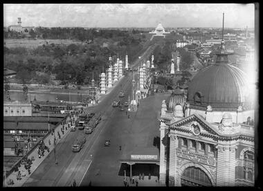
Photograph, Bull, Hugh Jones, 1897-1993, Princes Bridge Centenary pylons under construction
... structure was to have three arches each 96 feet wide measured across the river, and the banks on both sides were raised to allow more space for floodwater to flow. St Kilda Road was originally many feet below the current level. The bridge is of architectural significance for its substantial size, giant half columns, extensive use of wrought and cast iron, decorative elements (cast-iron lamps) and the skilled stonemasonry in the construction of the abutments and piers. Its main design features are similar to those of Blackfriars Bridge in London (1870). The bluestones...structure was to have three arches each 96 feet wide measured across the river, and the banks on both sides were raised to allow more space for floodwater to flow. St Kilda Road was originally many feet below the current level. The bridge is of architectural significance for its substantial size, giant half columns, extensive use of wrought and cast iron, decorative elements (cast-iron lamps) and the skilled stonemasonry in the construction of the abutments and piers. Its main design features are similar to those of Blackfriars Bridge in London (1870). The bluestones ...Princes Bridge Centenary pylons under construction Possibly taken from Young and Jacksons Hotel (formerly Princes Bridge Hotel) on the corner of Flinders and Swanston streets, Flinders Street Station’s clocks and main entrance dominate, along with its distinctive copper dome and decorative façade. The time on the main clock is 1.40pm, and the sign underneath, reflecting Melbourne’s upcoming Centenary reads, “We must accommodate our Centenary visitors! Citizens! Do your share by taking paying guests.” At left is the original Princes Bridge Station, today the site of Federation Square. The riverside tram terminus advertises a Café/Tobacconist/Refreshment Room selling cigars & cigarettes, fountain drinks & confectionery, and in smaller text: “Leave your boot repairs here”. Nearly everyone is dressed in dark suits, coats and hats. The footpaths are wide and there are no traffic lights. The roadway stretches towards the Shrine of Remembrance, not yet dedicated but very dominant on the skyline. Government House is clearly visible across the wide parkland that would come to be known as Kings Domain and that is an area of deep importance to the people of the Eastern Kulin. Originally, Birrarung was part of a network of swamps and lagoons linked to the course of the river. From 1896, Public Works Department engineer Carlo Catani, oversaw a new channel to straighten the river and the swamps and lagoons were filled with spoil from the channel works. From the same vantage point today, only the top of the tower of Government House would be visible. The photo captures the pylons along Princes Bridge, mid-construction and being installed to mark Melbourne’s Centenary. The pylons were not without controversy. Both The Argus and The Age bemoaned them for being “made almost entirely of imported softwood timber”, denying work to native hardwood timber workers and sawmillers, and leading visitors to think Australia did not have its own exceptional native hardwoods. The pylons were also variously described in their incomplete state, as unimaginative and resembling an oilfield. Published: The Age 5 September 1934 Featured in "Newsworthy: Melbourne in photographs 1933-1936" exhibition at East Melbourne Library, October to December 2023. Exhibition caption by project volunteer, Louise McKenzie Photographer notations on slide: "Pylons + St Kilda Rd C57" Published: Age (Melbourne, Vic. : 1854 - 1954), Wednesday 5 September 1934, page 11 Published title: DECORATIONS -- THEN AND NOW. Published caption: "Although not completed yet, some impression of the effect of the decorations on Princes-bridge may be obtained from the first picture which shows the majestic sweep of St Kilda road with the Shrine of Remembrance and Government House dominating the horizon. The area to the left of St. Kilda-road and in front of Government House is portion of the area which it is proposed to call the King's Domain, which extends to Domain-road and Anderson-street..." Description: East-facing, elevated view of Flinders Street Station and Princes Bridge, featuring partially completed pylons erected for Melbourne's Centenary celebrations. The Shrine of Remembrance and Government House can be seen in the distance. In the foreground are trams, cars and trucks, pedestrians, Batman Avenue tram terminus and refreshment rooms. Signage on Flinders Street Station encourages citizens to accommodate Centenary visitors. The Melbourne Centenary was held 1934-35 in celebration John Batman's proclamation that Melbourne "the place for a village". Centenary events included a visit by Prince Henry, Duke of Gloucester. A Centenary Cake measuring 50 feet in height and ten tons in weight was cut into 250,000 pieces and sold at 1 shilling per piece for charity. Spectacular floodlighting of city landmarks, the creation of the Pioneer Women's Memorial Garden, and the MacRobertson Air Race from London, were other notable activities. Research by project volunteer, Louise McKenzie: The photo in The Age collage of 5 September 1934 has a slightly cropped foreground. The original photo has been taken from an elevated vantage point, most probably the roof of the Nicholas Building on the corner of Flinders and Swanston streets. The right foreground is dominated by the main “clocks” entrance to Flinders Street Station, showing its distinctive copper dome and decorative façade. The time on the main clock is 1.40 pm. The main sign on the front of the Station reads, "We Must Accommodate our Centenary Visitors! Citizens! Do your share by taking paying guests. Write to The Official Centenary Accommodation Bureau, 436 Collins St. City. Tel M 4671”. Another sign at eye level at the main entrance says: “Cheap Trips on Sundays”. The sign on the end of the roof along the eastern side of the station reads, “The Babies Need Your Help! Support Broadmeadows Foundling Hospital Appeal. July and August”. Run by the Sisters of St Joseph of the Sacred Heart, St Joseph’s Foundling Hospital was a purpose built infants’ home for up to 300 babies, plus accommodation for expectant mothers, mainly single women. In the early 1930s, the department (Victorian Children’s Welfare Department) contracted St Joseph’s Foundling Hospital to care for an additional 60 infant state wards, and up to 175 non wards at any given time. In 1931 it also operated a mothercraft training school. The centre foreground shows the commencement of Princes Bridge. Beneath the left side of the bridge was the site of the original Princes Bridge Station, by this time incorporated into Flinders Street Station, and today the area is the site of Federation Square. It was linked to Flinders Street station by the railway tracks that ran underneath the northern approach to the bridge. This photo shows a tram terminus which has a Café/Tobacconist/Refreshment Room, selling cigars & cigarettes, fountain drinks & confectionary, and a sign: Leave your boot repairs here. In the foreground is a wide roadway running south/north, comprising two vehicle lanes each heading north/south, and a central section containing two sets of tram tracks. There are cars, buses and delivery vans on the roadway. The trams visible are Glen Iris (Route No. 6; tram no. 448), Toorak (Route No. 8, tram no. 333), ? (No. 7), ? (No. 1), and ? (No. 2A). The footpaths are extremely wide. There is a square newspaper/magazine stand on the eastern side footpath. And also a “Ferry” sign. There are no traffic lights, but a policeman is visible on the roadway. There are pedestrians – men, women, children, a porter with trolley, women with prams. Clothing comprises dark suits, coats and hats for nearly everyone. There are double headed “Collins Street” lights along the side of the roadway, and along the northern riverbank. The roadway in the foreground is an extension of Swanston Street, which becomes Princes Bridge, then St Kilda Road, stretching towards the Shrine of Remembrance, and diverting past it. The Shrine had not yet been officially dedicated, and looks very white and dominant on the skyline. On the LHS of St Kilda Road, Government House is clearly visible across the wide parkland to be known as Kings Domain. The Kings Domain area is important to the people of the Eastern Kulin nation, and also has historical importance for its association with the early settlement of Melbourne and the foundation of British colonial administration in Victoria. On the southern side of the Yarra River (Birrarung) an historic rowing boathouse is visible, located adjacent to the Alexandra Gardens. Originally Birrarung was part of a network of swamps and lagoons linked to the course of the river. From 1896, under the guidance of engineer Carlo Catani* a new channel to straighten the river was created and the swamps and lagoons were filled with spoil from the channel works. The gardens were then created and completed in time for a Royal visit by the Duke of York in May 1901. The gardens are named after Alexandra of Denmark, the wife of King Edward VII. Both these areas, plus the Royal Botanic Gardens Victoria, Shrine of Remembrance Reserve, Sidney Myer Music Bowl, Government House, and the Queen Victoria Gardens together form the Domain Parklands. The extent of the subsequent plantings is evident today, where from the same vantage point only the top of the tower of Government House would be visible. *Catani was born in Florence in 1852, but after arriving in Melbourne worked as a civil engineer for the Victorian Government. His last major project was the reclamation of the foreshore of St Kilda, envisaged in the style of a European resort, complete with a split level esplanade, bathing pavilions, dance halls, amusements and a French-Italian style of landscape complete with palms. The gardens at the end of Fitzroy Street, St Kilda, now bear his name. The historic boathouse visible across the Yarra is another glimpse into Melbourne’s past. “Boathouse Row” comprises 7 amateur rowing clubs, the first established in 1859 (Melbourne University Boat Club). Other Clubs were Richmond, Melbourne, Banks, Melbourne Grammar School, Yarra Yarra and Mercantile. South of the river and west of the bridge is an area today developed into the Melbourne arts precinct of Hamer Hall and the Arts Centre. But at this time it was the home of Wirths Olympia Circus, which comprised Wirths Pleasure Park (an amusement park), a 5,000 seat auditorium – Hippodrome, a roller skating rink, a glaciarium, a cinema, and the Green Mill Dance Hall. Dog shows were also held at Olympia. The Green Mill Dance Hall closed in 1950, and the remainder of the Wirth buildings on site were destroyed by fire in December 1953. The feature of the photo is the pylons erected along Princes Bridge to mark Melbourne’s Centenary in 1934. The sixteen plastered pylons were designed by Roy Prentice, the second person to qualify as an architect at The University of Melbourne’s Bachelor of Architecture degree, in 1933, aged 27. Simon Reeves in his article marking the 100th birthday of Roy Prentice on 20 June 2006 reports that the State Electricity Commission sponsored this work, and the Argus reported that “… the pylons were “illuminated from within to give the effect of soft radiance”. Australia Home Beautiful 1 Oct 1934 reports in a very detailed and comprehensive article: The 10 taller pylons, including flagpole, were 48 ft, with a base of 8 ft. Timber-framed and faced with fibrous plaster and galvanised sheet iron, each structure was securely bolted to a concrete foundation three feet in depth. Panels of glass let into the shaft of each pylon were indirectly lit by 40, 100 watt lamps, and the upper bank of internal lamps were dyed so as to flood the panels with a deep red light. The decorative painted shields and flagpoles/pennants were illuminated by three 200 watt projectors concealed in the roof of each pylon, and were part of an electric night light decoration scheme involving 28 miles of wire to supply more than 20,000 lights. An article in the Argus on 18 October 1934 provided minute detail of the lighting erected in Melbourne for the Centenary, converting it “… into a coloured fairyland by night.” The estimated cost of 10 pounds per hour the lights were on. The display included 800 standard light poles 30 feet high which were tiered with electric bulbs concealed in inverted cones, 138 specially designed “Venetian poles” draped in flags trophies and streamers. The streets included in the electric night light decoration scheme were Bourke Street from Spring to William, the entire length of Collins Street, Flinders Street from Elizabeth to Spring, Lonsdale Street from Elizabeth to Swanston, Swanston and Elizabeth Streets from Flinders to Lonsdale, and parts of Springs and Spencer Streets. Together with the Princes Bridge pylons, approximately 28 miles of wire was required to supply power to the more than 20,000 lights. And that is just in the city of Melbourne. It was estimated the same amount of lighting was duplicated among other local councils. The pylons were not without controversy. The Argus on 28 August 1934 in an article headed “Imported Timber in Pylons” reported that the Princes Bridge pylons are “made almost entirely of imported softwood timber”, and have therefore denied work to native hardwood timber workers and sawmillers. The same day the Melbourne Age ran a similar story, bemoaning the fact that foreign oregon had been used which may lead tourists to think Australia did not have its own exceptional native hardwoods. A Camberwell City Councillor described the pylons as unimaginative, and the Herald reported that skeletons of pylons for the Centenary decorations in their present form led the area to resemble an oilfield! The Yarra River and Princes Bridge have long been a focal point of Melbourne life. In the early days of European settlement in Melbourne a rope-hauled punt carried people across the Yarra River. A surge in population and increased shipping traffic created a need for a bridge. There was difficulty in agreeing on a suitable site for the bridge (options were crossing at Elizabeth, Swanston, Queen or Market Streets), but the NSW Government favoured Swanston Street and the Melbourne Town Council decided on a temporary bridge across the Yarra spanning from the foot of Swanston Street. This first bridge was a single span timber toll bridge designed by Scottish born bridge designer David Lennox, and completed in 1845. It was 120 feet long, had a roadway of 17 feet wide, and a footpath on one side of 4 feet. It was leased to the Melbourne Bridge Company in the name of Robert A Balbirnie. The tollhouse was on the north side of the river and the toll keeper, Patrick Doherty, was credited with saving nine lives during the four years he was in charge of the toll station. The second bridge was stone (completed 1850), and named Prince’s Bridge after the HRH Prince of Wales, later Edward VII. It was designed with an elliptical single arc and an exceedingly small rise in proportion to the span. However, this design created an obstacle for flood waters, and together with Melbourne’s increasing population it was quickly apparent that a new bridge was required. At its opening on 15 November 1850 coincided with the imminent declaration of Victoria as a separate colony, it provided a moment of great celebration for Melbournians and “The opening ceremony was described as the grandest processional display witnessed in the colony.” (ToMelbourne.com.au) Princes Bridge in its present form, as depicted in this photograph, was designed by Jenkins, D’Ebro and Grainger, and constructed in 1886-88 by David Munro. John Grainger (father of Australian composer Percy Grainger) did the majority of the design work for the bridge. The structure was to have three arches each 96 feet wide measured across the river, and the banks on both sides were raised to allow more space for floodwater to flow. St Kilda Road was originally many feet below the current level. The bridge is of architectural significance for its substantial size, giant half columns, extensive use of wrought and cast iron, decorative elements (cast-iron lamps) and the skilled stonemasonry in the construction of the abutments and piers. Its main design features are similar to those of Blackfriars Bridge in London (1870). The bluestones were quarried from Footscray, the Malmsbury stones were from quarries at Kyneton, and the granite from Harcourt. The cost was met by the State of Victoria, City of Melbourne, and six out of seven of its municipalities, and their coats of arms feature on the bridge. The building of the bridge reflected the boom period of Melbourne, including the Victorian gold rush 1851- late 1860s, and its contractor, David Munro, was also responsible for the construction of Queens Bridge and Sandridge Railway Bridge. The Centenary pylons are no longer in place, but today this intersection still plays a major part in Melbourne’s daily life: people still meet “under the clocks” at Flinders Street station, and the route in and out of the city along St Kilda Road is often a feature of parades such as Moomba, the Grand Final Parade, and of course the Anzac Day Parade which commences at the Princes Bridge intersection and finishes at the Shrine of Remembrance. There are many tram routes, which cross the Bridge, and it directs pedestrians towards the Arts Precinct, the various components of Domain Park, plus the Southbank restaurant and rowing precincts. Even though this is a street scene, it feels very intimate; the viewer is instantly immersed in the activity of a Melbourne afternoon, looking down St Kilda Road from a viewpoint near today’s Federation Square. References: DECORATIONS -- THEN AND NOW. (1934, September 5). The Age (Melbourne, Vic. : 1854 - 1954), p. 11. Retrieved September 21, 2023, from http://nla.gov.au/nla.news-article205880269 'Flinders Street railway station', Wikipedia, https://en.wikipedia.org/wiki/Flinders_Street_railway_station 'St Joseph’s Foundling Hospital (1901-75)', Finding Records, Department of Health and Human Services, State of Victoria, https://www.findingrecords.dhhs.vic.gov.au/collectionresultspage/St-JosephsFoundling-Hospital-Babies-Home#departmental-administration 'Alexandra Gardens', City of Melbourne, https://www.melbourne.vic.gov.au/community/parks-open-spaces/major-parks-gardens/Pages/alexandra-gardens.aspx 'Wirths Circus', Wikipedia, https://en.wikipedia.org/wiki/Wirth's_Circus 'Roy Prentice: Centenary Architect', Built Heritage Pty Ltd, Simon Reeves, https://www.builtheritage.com.au/downloads/prentice.pdf 'Princes Bridge', Heritage Council Victoria, https://vhd.heritagecouncil.vic.gov.au/places/817 PORT PHILLIP. (1846, April 1). The Sydney Morning Herald (NSW : 1842 - 1954), p. 3. Retrieved September 21, 2023, from http://nla.gov.au/nla.news-article12886251 'Edward VII', Wikipedia, https://en.wikipedia.org/wiki/Edward_VII 'Princes Bridge', ToMelbourne.com, https://tomelbourne.com.au/princes-bridge/ 'Princes Bridge', eMelbourne, https://www.emelbourne.net.au/biogs/EM01189b.htm 'Princes Bridge', Australia for everyone, http://australiaforeveryone.com.au/files/melbourne/princes-bridge.html 'Victorian gold rush', Wikipedia, https://en.wikipedia.org/wiki/Victorian_gold_rush IMPORTED TIMBER IN PYLONS (1934, August 28). The Argus (Melbourne, Vic. : 1848 - 1957), p. 9. Retrieved September 21, 2023, from http://nla.gov.au/nla.news-article10952507 Princes-Bridge Pylons. (1934, August 28). The Age (Melbourne, Vic. : 1854 - 1954), p. 7. Retrieved September 21, 2023, from http://nla.gov.au/nla.news-article205532235 Pylons Appear Near Princes Bridge (1934, August 18). The Herald (Melbourne, Vic. : 1861 - 1954), p. 1. Retrieved September 21, 2023, from http://nla.gov.au/nla.news-article243104375 PRINCES-BRIDGE PYLONS. (1934, September 20). The Age (Melbourne, Vic. : 1854 - 1954), p. 10. Retrieved September 21, 2023, from http://nla.gov.au/nla.news-article205873535 28 Miles of Wire (1934, October 18). The Argus (Melbourne, Vic. : 1848 - 1957), p. 1 (The Junior Argus). Retrieved September 21, 2023, from http://nla.gov.au/nla.news-article10977836 'Historical references for Boathouse Row, Melbourne', http://boathouserowmelbourne.com.au/history/ 'ITALIAN DELEGATION TO HONOUR CARLO CATANI, DESIGNER OF THE ST KILDA FORESHORE, St Kilda Historical Society, 2001, https://web.archive.org/web/20070928061938/http://www.skhs.org.au/~SKHSarticles/articles/Carlo_Catani.html# HISTORY IN LIGHTS (1934, July 12). The Herald (Melbourne, Vic. : 1861 - 1954), p. 16. Retrieved September 21, 2023, from http://nla.gov.au/nla.news-article243172436 'Dressing Melbourne for the Duke', The Australian home beautiful: a journal for the home builder. Vol 12 No. 10 (1 October 1934), page 21, 58. Retrieved September 14, 2023, from http://nla.gov.au/nla.obj-2950922209Photographer notations on slide: "Pylons + St Kilda Rd C57".centenaries, bridges, lighting, flinders street railway station -
 Sunshine and District Historical Society Incorporated
Photograph - Bluestone quarry
... Stone quarry probably bluestone On the site of where the Sunshine Plaza now stands Service Street Hampshire Road and Hertford Road Note center bottom features head of what appears to be bluestone pitchers used for forming gutters at sides of streets Three horse drawn tip drays and most likely owner drivers This was the most commonly used means of transporting stone up to the early 1930s The structures featured housed stone crushing equipment...Quarry Sunshine Plaza Hampshire Road Sunshine Stone quarry probably bluestone On the site of where the Sunshine Plaza now stands Service Street Hampshire Road and Hertford Road Note center bottom features head of what appears to be bluestone pitchers used for forming gutters at sides of streets Three horse drawn tip drays and most likely owner drivers This was the most commonly used means of transporting stone up to the early 1930s The structures featured housed stone crushing equipment Bluestone quarry Photograph Bluestone quarry ...Stone quarry probably bluestone On the site of where the Sunshine Plaza now stands Service Street Hampshire Road and Hertford Road Note center bottom features head of what appears to be bluestone pitchers used for forming gutters at sides of streets Three horse drawn tip drays and most likely owner drivers This was the most commonly used means of transporting stone up to the early 1930s The structures featured housed stone crushing equipmentquarry, sunshine plaza, hampshire road, sunshine -
 City of Ballarat
Public Artwork, Eternal Flame by Peter Blizzard, 1995
... Engraved into the bluestone shaped tile across the base of the statue is details about conflict areas where Australian Troops were active. The metal structure...Engraved into the bluestone shaped tile across the base of the statue is details about conflict areas where Australian Troops were active. The metal structure ...Eternal Flame was created by Ballarat sculptor Peter Blizzard as a marker of the end of WWII in the Pacific. Engraved into the bluestone shaped tile across the base of the statue is details about conflict areas where Australian Troops were active. The metal structure mimics a moving flame with it's polished golden hue, a feature included in many war memorials around the world. Peter Blizzard also designed the Prisoner of War Memorial in the South Gardens, Ballarat Botanic Gardens. The metal structure mimics the moving flame of polished golden hue that is present in war memorials around the world. Eternal flame is aesthetically and historically significant to the people of BallaratMetal construction on bluestone tile baseConflict areas for Australian Troops are engraved into bluestone shaped tile across the base of the statue. eternal flame, world war ii, conflict, peter blizzard, australian sculpture -
 Hume City Civic Collection
Photograph, 1970s
... The bluestone bridge which spans the Jacksons Creek was built in 1857 and replaced a laminated timber bridge. In the 1970s the stone bridge was replaced with a wider cement structure to accommodate the increased traffic flow....Hume City Civic Collection 44 Macedon Street Sunbury melbourne The bluestone bridge which spans the Jacksons Creek was built in 1857 and replaced a laminated timber bridge. In the 1970s the stone bridge was replaced with a wider cement structure to accommodate the increased traffic flow. macedon street road bridge harris thomas lascelles jacksons creek george evans collection A black and white photograph of the bluestone Macedon road bridge over the Jacksons Creek Photograph ...The bluestone bridge which spans the Jacksons Creek was built in 1857 and replaced a laminated timber bridge. In the 1970s the stone bridge was replaced with a wider cement structure to accommodate the increased traffic flow.A black and white photograph of the bluestone Macedon road bridge over the Jacksons Creekmacedon street road bridge, harris, thomas lascelles, jacksons creek, george evans collection -
 Hume City Civic Collection
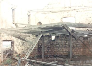
Photograph
... The bluestone is exposed on the lower half of the walls but the walls on the upper storey have either been rendered or painted. Part of the interior wooden structure...The bluestone is exposed on the lower half of the walls but the walls on the upper storey have either been rendered or painted. Part of the interior wooden structure ...Rosenthal Winery in Vineyard Road, Sunbury was one of the first wineries established in the area. It was owned by R. F. Kurrle. The roofless building still stands on the property which was part of the dairy farm owned by Tom and Angela Millett. The last vintage from the property was crushed in 1910.A coloured photograph of shell of the interior of the Rosenthal Winery. The bluestone is exposed on the lower half of the walls but the walls on the upper storey have either been rendered or painted. Part of the interior wooden structure is still standing. There is an open doorway on the LHS with two windows above it. Two smaller windows are on the lower part of another wall with a larger window above them. The building is roofless.rosenthal winery, wineries, vineyards, vineyard road, sunbury wineries, kurrle, r. f., millett, tom, angela, sunbury, george evans collection -
 Hume City Civic Collection
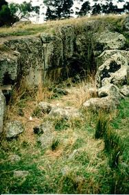
Photograph, Early 1990's
... This is the remains of a bluestone quarry on the 'Oaklands' property at Oaklands Junction. stone structures oaklands quarry george evans collection A coloured photograph in portrait format of a basalt rock ruined structure which has been dug into a hillside with a line of trees in the background. ...This is a photograph of one of the many stone ruins which can be seen in the Sunbury area and surrounding districts. These ruins are found in varying degrees of structural damage caused by erosion, vegetation growth and vandalism. This is the remains of a bluestone quarry on the 'Oaklands' property at Oaklands Junction.A coloured photograph in portrait format of a basalt rock ruined structure which has been dug into a hillside with a line of trees in the background.stone structures, oaklands quarry, george evans collection -
 Hume City Civic Collection
Photograph, late 1990s
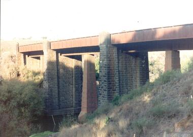
... The bridge constructed from bluestone, brick and iron over the Jacksons Creek at Sunbury is an important structure on the Melbourne-Echuca rail line. ...Hume City Civic Collection 44 Macedon Street Sunbury melbourne The bridge constructed from bluestone, brick and iron over the Jacksons Creek at Sunbury is an important structure on the Melbourne-Echuca rail line. ...The bridge constructed from bluestone, brick and iron over the Jacksons Creek at Sunbury is an important structure on the Melbourne-Echuca rail line. The foundation stone for the bridge was laid on 13 January 1859 and the bridge opened in July 1861. It is of state significance.A coloured photograph of the bluestone and iron railway bridge which is ove the Jacksons Creek. The bridge has 3 bluestone pylons and three iron pylons with 3 sections of the iron spans visible across the top.transport, bridges, rail transport, darbyshire, g. c., jacksons creek, george evans collection -
Hume City Civic Collection
Photograph, St. Mary's Church, Bulla, 1970S
... structure from vibrations caused by lowlying aircraft. Churches St. Mary's Anglican Church - Bulla Bulla Tullamarine Airport A coloured non-digital photograph of a small bluestone church set in an open area with a line of gum trees in the background. ...The church in the image is St. Mary's Church of England in Bulla after it was moved from its original location at the corner of Oaklands and Sunbury Roads to the Bulla township adjacent to the former Bulla Shire Officers. The move was necessary because the building was close to the international airport and its location interfered with the airport's signaling system and cracks were appearing in its structure from vibrations caused by lowlying aircraft.A coloured non-digital photograph of a small bluestone church set in an open area with a line of gum trees in the background.churches, st. mary's anglican church - bulla, bulla, tullamarine airport -
 Port Fairy Historical Society Museum and Archives
Photograph
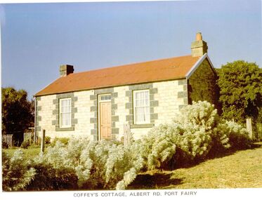
... bluestone quoins, gabled roof, chimneys at each end and a skillion on the western side, added at a later date. It was originally a two-roomed dwelling with kitchen. Behind the cottage is a slab-sided wooden gable ended shed, containing a large limestone rubble chimney and a sleeping area within the south facing skillion section. It is unlikely that it is older than the cottage, but it is an unusual, crude structure...bluestone quoins, gabled roof, chimneys at each end and a skillion on the western side, added at a later date. It was originally a two-roomed dwelling with kitchen. Behind the cottage is a slab-sided wooden gable ended shed, containing a large limestone rubble chimney and a sleeping area within the south facing skillion section. It is unlikely that it is older than the cottage, but it is an unusual, crude structure ...65 Albert Road. the land was first owned by George Bull when he bought it in 1860. The house was built around 1862. Members of the family owned it until 1893 when it was sold to William Johnson. Johnson died in 1897 and Catherine Sara Ryan nee Hain bought it and lived there until she died in 1927. The cottage was then sold to the Coffey family who retained the property until 1974. The cottage is conventional coursed limestone building with bluestone quoins, gabled roof, chimneys at each end and a skillion on the western side, added at a later date. It was originally a two-roomed dwelling with kitchen. Behind the cottage is a slab-sided wooden gable ended shed, containing a large limestone rubble chimney and a sleeping area within the south facing skillion section. It is unlikely that it is older than the cottage, but it is an unusual, crude structure, presumably for general farming purposes.Coloured photographcottage, building, home, house, coffey's cottage, albert road, ryan, hain, johnson, george bull -
 Sunbury Family History and Heritage Society Inc.
Photograph, Bulla Bridge, c 1980s
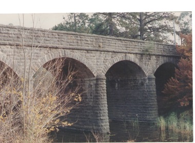
... The bridge in the photograph is the bluestone bridge at Bulla which spans the Deep Creek, a tributary of the Maribyrnong River. It was built in 1869 and replaced a ford crossing which was built further downstream. Many of the buildings and structures... in the area were built from bluestone which is in abundance throughout this volcanic area. This bridge is one of many similar structures built across Western Victoria where the bluestone volcanic rock was found in abundance. ...The bridge in the photograph is the bluestone bridge at Bulla which spans the Deep Creek, a tributary of the Maribyrnong River. It was built in 1869 and replaced a ford crossing which was built further downstream. Many of the buildings and structures in the area were built from bluestone which is in abundance throughout this volcanic area.This bridge is one of many similar structures built across Western Victoria where the bluestone volcanic rock was found in abundance. It has been classified as being of local heritage significance.A non-digital coloured close - up photograph of a four-arched blue stone bridge spanning a waterway. Some greenery is visible on either side of the bridge and above it. bulla bridge, bluestone, bridges, deep creek. -
 Melton City Libraries
Photograph, Melton Uniting Church Opportunity Shop volunteers, 1993
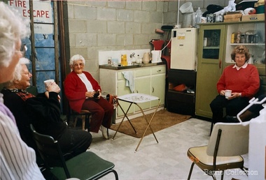
... Bluestone Church (known as Melton Uniting Church - 1977). A large proportion of finance for this project was contributed by the Opp Shop $16,000. Simultaneously finance was being built up to provide further facilities at Brooklyn Rd, resulting in the commencement of a concrete block masonry and steel extension, with facilities & fittings, being commenced during 1986 & completed in 1989. The approximate total cost of this structure...Bluestone Church (known as Melton Uniting Church - 1977). A large proportion of finance for this project was contributed by the Opp Shop $16,000. Simultaneously finance was being built up to provide further facilities at Brooklyn Rd, resulting in the commencement of a concrete block masonry and steel extension, with facilities & fittings, being commenced during 1986 & completed in 1989. The approximate total cost of this structure ...In the early l 970's , when our population was increasing rapidly and resident ministers were needed at both Melton and Bacchus Marsh, and after discussion between both denominations over many months a decision was reached , that in both areas they would unite and be known as Methodist - Presbyterian joint parishes. In 1972 Ministers were appointed, and Melton's minister occupied one of the Bacchus Marsh Manses during the building of Melton's church residence in Y uille Street. Services were held at Scots Presbyterian Church Melton. Youth Club and church meetings were held in the Methodist Church at Brooklyn Road, Melton South. At a joint Parish Committee Meeting held in May 1975 at Melton South - a major item of business was finance, to meet the repayments on the recently built Church Manse and the minister's Stipend. The meeting closed without any solution to this problem being made. As the men restacked the chairs Maisie and I viewed the building with the possibility of opening an Opp Shop on the premises. We then made the suggestion to the other members and during the forthcoming weeks investigations concerning the feasibility of this idea were made, volunteers recruited and the shop opened in July 1975. The first contribution to the Church funds of $1,600 was made in 1976 and was followed by regular contributions to the church budget each year. In 1981 a 30'x 20' steel garage costing $2,000 was erected adjacent to the original Methodist Church to provide more space. Meanwhile an Opp Shop was opened in Melton Markets and operated from 1981 to 1985. Further accommodation was needed at Yuille Street and the Atco Hall was installed at the rear of the Bluestone Church (known as Melton Uniting Church - 1977). A large proportion of finance for this project was contributed by the Opp Shop $16,000. Simultaneously finance was being built up to provide further facilities at Brooklyn Rd, resulting in the commencement of a concrete block masonry and steel extension, with facilities & fittings, being commenced during 1986 & completed in 1989. The approximate total cost of this structure was $60,000. Over the 16 years, members and friends of our church have contributed many many hours to staff the shop and many other supportive works. As an acknowledgement of their efforts, our Minister prepared Certificates for Service and Dedication which were presented to 75 supporters at a special Church Service in June 1991. The assistance that has been given to the community of Melton & District has been extensive and much appreciated by many families. In addition many appeals for goods and clothing have been received and packages sent to many outside supportive agencies. Three volunteers having a tea break in the staffroom of the Op Shoplocal identities, churches -
 Melton City Libraries
Photograph, Melton Railway Bridge, c.1884
... bluestone with drafted margins. The larger half-piers, now usually submerged in the Melton Reservoir have sharp tapered cutwaters and curved coping at the tops. While designed to carry two rail tracks it has only ever been used as a single track line. Despite several alterations to its deck structure...bluestone with drafted margins. The larger half-piers, now usually submerged in the Melton Reservoir have sharp tapered cutwaters and curved coping at the tops. While designed to carry two rail tracks it has only ever been used as a single track line. Despite several alterations to its deck structure ..."The Melton Viaduct, opened in 1886, is of State heritage significance as a very large and visually distinctive wrought iron, lattice girder trestle bridge over the Werribee River (now Melton Reservoir). It comprises 18.3 and 9.1 metre spans, in a generally alternate arrangement, of total length 375 metres, and standing 38 metres over the Werribee River. Wrought iron small section iron was used to build tension trussed trestle legs, which supported four lines of rivetted wrought-iron deck-type double lattice trusses. It has bluestone abutments and pier bases of coursed rock-faced bluestone with drafted margins. The larger half-piers, now usually submerged in the Melton Reservoir have sharp tapered cutwaters and curved coping at the tops. While designed to carry two rail tracks it has only ever been used as a single track line. Despite several alterations to its deck structure, it remains an outstanding example of a lighter structural design employing open metal trestle supports and metal truss girders. The direct Melbourne to Ballarat railway link of which the Melton viaduct was the major engineering work contributed significantly to the history and development of Victoria. This new link reflected Ballarat’s diversifying economy as well as the commercial and political influence of the metropolis. Construction of the bridge, and the associated large workers camp, were extensively photographed, documenting an important episode in local history. The railway enabled the development of new industries in the Melton area, notably the timber industry and a chaff industry of national importance, greatly facilitated the later transition of the Shire from a pastoral to a farming economy, and struck a major blow to Melton township’s era as a wayside town servicing Ballarat road (especially coach) traffic". Melton Railway Bridge being built across the Werribee Rivertransport -
 Bacchus Marsh & District Historical Society
Book, Hills of Home: A Biography of Robert Lawson
... The school building was an imposing bluestone structure which came to be known as Landsberg House.The school was very successful for a time in the 1860s attracting students from across Victoria. ...Robert Lawson was the first Principal of Scotch College in Melbourne. He was Principal of Scotch College from 1851 until 1856. He later acquired land in the Pentland Hills near Bacchus Marsh and operated a school at Blackwood which he called the Landsberg Mains School. It was also known as the Landsberg Academy. The school opened in 1857 and operated under Lawson's direction until 1868. The school building was an imposing bluestone structure which came to be known as Landsberg House.The school was very successful for a time in the 1860s attracting students from across Victoria. Lawson died in 1869 and the school continued to operate until 1880 under a different Principal. Lawson is considered a pioneer educationalist in Australia. This is a substantial and scholarly biography about Lawson and his wife Isabella Wilson. Several chapters explore the time Lawson spent operating his school at Blackwood.Book, hard cover. First edition. Melbourne, Vic., Melbourne University Publishing, 2009. By David Baillieu. 389 pages. BMDHS Location: AR/SU63/S2 non-fictionRobert Lawson was the first Principal of Scotch College in Melbourne. He was Principal of Scotch College from 1851 until 1856. He later acquired land in the Pentland Hills near Bacchus Marsh and operated a school at Blackwood which he called the Landsberg Mains School. It was also known as the Landsberg Academy. The school opened in 1857 and operated under Lawson's direction until 1868. The school building was an imposing bluestone structure which came to be known as Landsberg House.The school was very successful for a time in the 1860s attracting students from across Victoria. Lawson died in 1869 and the school continued to operate until 1880 under a different Principal. Lawson is considered a pioneer educationalist in Australia. This is a substantial and scholarly biography about Lawson and his wife Isabella Wilson. Several chapters explore the time Lawson spent operating his school at Blackwood. schools bacchus marsh region, schools blackwood victoria, landsberg academy, robert lawson 1826-1869, isabella lawson -
 Ballarat Heritage Services
Photograph, Former Buninyong Swimming Pool
... bluestone water reservoir, it was used as a swimming pool from 1872 to the 1930s. The site is listed on the Victorian Heritage Register and remains a significant past of Buninyong's social and recreational history. In 2025 a project was started to stabilise and preseve the 160 year old structure...bluestone water reservoir, it was used as a swimming pool from 1872 to the 1930s. The site is listed on the Victorian Heritage Register and remains a significant past of Buninyong's social and recreational history. In 2025 a project was started to stabilise and preseve the 160 year old structure ...Originally built as a bluestone water reservoir, it was used as a swimming pool from 1872 to the 1930s. The site is listed on the Victorian Heritage Register and remains a significant past of Buninyong's social and recreational history. In 2025 a project was started to stabilise and preseve the 160 year old structure by adding new foundattons, replacing damages wall panels, sealing cracks and improving drainage. Vegetations from inside the pool was cleared and reinsation is planned once works are finishes (around June 2026)Colour photographs of the former Buninyong Baths in the Buninyong Botanical Gardens.buninyong swimming pool, buninyong baths, pre-olympic swimming pool -
 Sunbury Family History and Heritage Society Inc.
Photograph
... Four bluestone gate posts support the entire structure....Four bluestone gate posts support the entire structure. Photograph ...The white painted cast iron gates are at the front entrance to St. Andrews Uniting Church and front onto the former Stawell Street in Sunbury. They were originally manufactured at the H.V.McKay Harvester Works in Sunshine. Over the years the gates fell into disrepair and were eventually restored and reinstalled at the original site.The church gates are of historical importance in Sunbury as a result of H.V.McKay's connection with the former Presbyterian Church. He is buried in the Sunbury Cemetery and also lived at Rupertswood from 1923 until his death in 1926.A coloured photograph of red brick church and the double cast iron gates, flanked by a single gate on each side at the front entrance. Four bluestone gate posts support the entire structure.st. andrews uniting church, main gates, stawell street, sunbury, h.v. mckay -
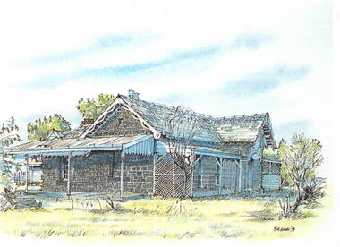 Sunbury Family History and Heritage Society Inc.
Photograph, Bill Walls, c1978
... bluestone walls and a slate roof. There is a closed-in addition building on one side and a verandah across the front with a lean-to structure on the other end of the building....bluestone walls and a slate roof. There is a closed-in addition building on one side and a verandah across the front with a lean-to structure on the other end of the building. ...The building in the sketch is the former Manse for the Bulla Presbyterian Church. The artist was Bill Walls who did a number of similar sketches of historic buildings and sites in the Sunbury and Bulla area in the 1970s.A photograph of a coloured sketch of a house with bluestone walls and a slate roof. There is a closed-in addition building on one side and a verandah across the front with a lean-to structure on the other end of the building.bulla, presbyterian church, manse