Showing 193 items matching " contour"
-
 Greensborough Historical Society
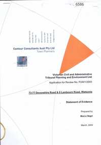
Document, Statement of evidence: VCAT Application P2461/2003, prep. by Marco Negri, Contour Consultants Aust Pty Ltd, 2004_03
... Statement of evidence: VCAT Application P2461/2003, prep. by Marco Negri, Contour Consultants Aust Pty Ltd...Contour Consultants Aust Pty Ltd...Contour Consultants Aust Pty Ltd...Statement of evidence: VCAT Application P2461/2003, prep. by Marco Negri, Contour Consultants Aust Pty Ltd Document Contour Consultants Aust Pty Ltd Marco Negri Contour Consultants Aust Pty Ltd Marco Negri ...Lawyers for the City of Banyule commissioned a report on the town planning implications of a proposal to construct a multi-level building on land at the corner of Lambourn and Devonshire Roads Watsonia, relating to the Council's refusal of a permit and the subsequent hearing by VCAT22 p., black & white with col. plans.watsonia, lambourn road watsonia, devonshire road watsonia -
 University of Melbourne, Burnley Campus Archives
Plan - Photocopy, Contour Map 1891, 1891
... Contour Map 1891...Photocopy of plan showing contour lines from Yarra River. Shows Pavilion and Principal's Residence but not much of the garden design. ..."Contour map 1891" written in biro...University of Melbourne, Burnley Campus Archives 500 Yarra Boulevard Richmond melbourne yarra river pavilion Burnley Horticultural College Burnley Gardens "Contour map 1891" written in biro Photocopy of plan showing contour lines from Yarra River. ...Photocopy of plan showing contour lines from Yarra River. Shows Pavilion and Principal's Residence but not much of the garden design. From Central Plan Office Dept. of Natural Resources."Contour map 1891" written in biroyarra river, pavilion, burnley horticultural college, burnley gardens -
 Robin Boyd Foundation
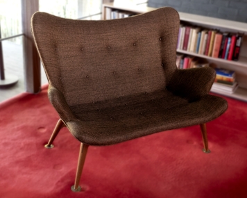
Furniture - Sofa, Grant Featherston, RS161 Featherston Contour Settee, 1951
... RS161 Featherston Contour Settee...This pair of RS161 Grant Featherston Contour Settees (1951) were previously in the Boyd home in Camberwell. ...Twenty five self-covered buttons. Curvaceous contour shape....Twenty five self-covered buttons. Curvaceous contour shape. RS161 Featherston Contour Settee Furniture Sofa Grant Featherston ...This pair of RS161 Grant Featherston Contour Settees (1951) were previously in the Boyd home in Camberwell. Robin Boyd designed the Ivanhoe home and Grant and Mary Featherston (1967).Two two-seater settees, with four timber cigar shaped legs with round flat metal brass feet. Olive green/copper loose weave fabric. Wool/silk blend fabric. Twenty five self-covered buttons. Curvaceous contour shape.walsh st furnishings, settee, featherston, robin boyd -
 National Vietnam Veterans Museum (NVVM)
Map, A Contour Map of South Vietnam
... A Contour Map of South Vietnam....A contour map showing ATF Base Patrols....National Vietnam Veterans Museum (NVVM) 25 Veterans Drive Newhaven phillip-island-and-the-bass-coast ATF Base Patrols A contour map showing ATF Base Patrols. A Contour Map of South Vietnam. ...A contour map showing ATF Base Patrols.atf base patrols -
Broadmeadows Historical Society & Museum
Map - Map of Australia, John Bartholomew & Son Ltd, Contour- coloured world map series: Australia, c. 1955
... Contour- coloured world map series: Australia...Map of Australia - Colour contoured - printed on cloth, scale 1:5,000,000...Broadmeadows Historical Society & Museum 21 Pearcedale Parade Broadmeadows melbourne Printed 1955 Quality Map in good condition, can be used for research purposes Australia Map Historical information Education Map of Australia - Colour contoured - printed on cloth, scale 1:5,000,000 Contour- coloured world map series: Australia Map Map of Australia John Bartholomew & Son Ltd Mr. ...Printed 1955Quality Map in good condition, can be used for research purposesMap of Australia - Colour contoured - printed on cloth, scale 1:5,000,000australia, map, historical information, education -
Surrey Hills Historical Society Collection
Map, Contour map of Surrey Hills showing potential sites for the Telecom Tower
... Contour map of Surrey Hills showing potential sites for the Telecom Tower...Two A3 photocopied sheets of a map showing part of Surrey Hills, roughly between Windsor Crescent and Belmont Street (north / south) and Standard Avenue and Balmoral Crescent (east / west). The map shows contour lines and house sites, 16 of which are numbered. ..."Contour map of potential sites / for the telecommunications tower which / was eventually sited at 2. / Jock Campbell OBE was our neighbour / at 4 Theodore St when we moved into / the area in 1984. ...The location is said to be the second highest site in Melbourne, sometimes described as Delaney's Hill. contour map Telecom tower maps Jock Campbell John Duncan Campbell "Contour map of potential sites / for the telecommunications tower which / was eventually sited at 2. / Jock Campbell OBE was our neighbour / at 4 Theodore St when we moved into / the area in 1984. ...The PMG / Telecom / Telstra tower was built in 1961-1963 as a relay station to support television and radio links between city and regional broadcasting stations. The tower itself was 45 m in height with a 2 storey building for equipment and staff surrounded by garden. From the beginning it was opposed by local residents. The location is said to be the second highest site in Melbourne, sometimes described as Delaney's Hill.Two A3 photocopied sheets of a map showing part of Surrey Hills, roughly between Windsor Crescent and Belmont Street (north / south) and Standard Avenue and Balmoral Crescent (east / west). The map shows contour lines and house sites, 16 of which are numbered. One sheet has been inscribed in top RH corner with notes regarding the significance of the numbers."Contour map of potential sites / for the telecommunications tower which / was eventually sited at 2. / Jock Campbell OBE was our neighbour / at 4 Theodore St when we moved into / the area in 1984. He was responsible in his / job at the PMG in deciding on the /site of the tower - Note site 5 was / behind his (& our) house. / Jack ended his career as Deputy Director / of the PMG. He sat on international committees / after WW2 to decide the split of the electronic / spectrum for radio, TV etc. / His group developed a "mobile phone" using / fixed towers but the phone was a truck full of gear."contour map, telecom tower, maps, jock campbell, john duncan campbell -
Port Melbourne Historical & Preservation Society
Document - Reports, Contour Consultants to panel reviewing C5 amendment to Port Phillip Planning Scheme, Contour Consultants, 1999
... Developer submissions to an independent Panel reviewing the C5 amendment to the Port Phillip Planning Scheme, 1999 Report from Contour Consultants re. 15 Beach St...Contour Consultants...Heritage overlays to protect heritage areas were also under review. town planning built environment - civic heritage becton fox hay timber and hardware pty ltd Developer submissions to an independent Panel reviewing the C5 amendment to the Port Phillip Planning Scheme, 1999 Report from Contour Consultants re. 15 Beach St Document Reports, Contour Consultants to panel reviewing C5 amendment to Port Phillip Planning Scheme Contour Consultants ...The C5 Amendment aimed to create a framework for built form and development controls in the Port Melbourne Mixed Use Area undergoing conversion to residential development. Heritage overlays to protect heritage areas were also under review.Developer submissions to an independent Panel reviewing the C5 amendment to the Port Phillip Planning Scheme, 1999 Report from Contour Consultants re. 15 Beach Sttown planning, built environment - civic, heritage, becton, fox hay timber and hardware pty ltd -
 Federation University Historical Collection
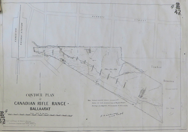
Plan, Contour Plan of the Canadian Rifle Range Ballaarat, 1906, 12/10/1906
... Contour Plan of the Canadian Rifle Range Ballaarat, 1906...Copy of a contour plan of the Canadian Rifle Range, on the outskirts of Ballarat. ...canadian rifle range canadian railway station g.f. wilkinson ranger's quarters magazine bennett street, canadian Copy of a contour plan of the Canadian Rifle Range, on the outskirts of Ballarat. ...Copy of a contour plan of the Canadian Rifle Range, on the outskirts of Ballarat. The Rifle Range was in close proximity to the former Canadian Railway Station.canadian rifle range, canadian railway station, g.f. wilkinson, ranger's quarters, magazine, bennett street, canadian -
 Federation University Historical Collection
Program, Booklet, Newspaper Cuttings, Map, Mount Lyell Contour Map
... Mount Lyell Contour Map...Copy of a contour map of Mount Lyell, Tasmania, showing the mining areas of West Lyell, Glen Lyell. ...mount lyell tasmania contour map Copy of a contour map of Mount Lyell, Tasmania, showing the mining areas of West Lyell, Glen Lyell. ...Copy of a contour map of Mount Lyell, Tasmania, showing the mining areas of West Lyell, Glen Lyell. Gormanston, Cape Horn and Comstock.mount lyell, tasmania, contour map -
 Bendigo Art Gallery
Furniture, Grant FEATHERSTON, A310 Contour chair (pair), 1953
... A310 Contour chair (pair)...... contour...Bendigo Art Gallery 42 View Street Bendigo goldfields decorative arts chair chairs Featherston A310 contour chair contour None A310 Contour chair (pair) Furniture Grant FEATHERSTON ...Nonedecorative arts, chair, chairs, featherston, a310 contour chair, contour -
University of Melbourne, Burnley Campus Archives
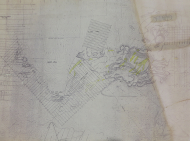
Plan - Photocopy, Edward Owens, Contour Plan of the Town of Richmond, 1873
... Contour Plan of the Town of Richmond...Photocopy of Contour Plan of the Town of Richmond prepared by M. ...Egan Edward Owens Town of Richmond contour plan "State Library Vic." in ink Photocopy of Contour Plan of the Town of Richmond prepared by M. ...Photocopy of Contour Plan of the Town of Richmond prepared by M. Egan, Architect and Edward Owens, Cont. Surveyor, 25.03.1873. Plan C. Shows proposed Main Drains and Horticultural Garden. From State Library of Victorian VSL 821.08 Richmond 1873"State Library Vic." in inkdrainage, burnley horticultural gardens, m. egan, edward owens, town of richmond, contour plan -
 Kew Historical Society Inc
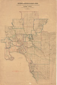
Plan, Melbourne & Metropolitan Board of Works : Contour Plan of Melbourne & Suburbs : Melbourne Sewage, 1894
... Melbourne & Metropolitan Board of Works : Contour Plan of Melbourne & Suburbs : Melbourne Sewage...Digital copy of an original MMBW plan. This contour plan shows the area identified by the MMBW for purposes of drainage and sewerage in 1894. ...This contour plan shows the area identified by the MMBW for purposes of drainage and sewerage in 1894. ...The Melbourne and Metropolitan Board of Works (MMBW) plans were produced from the 1890s to the 1950s. They were crucial to the design and development of Melbourne's sewerage and drainage system. This plan forms part of a large group of MMBW plans and maps that was donated to the Society by the Mr Poulter, City Engineer of the City of Kew in 1989. Within this collection, thirty-five hand-coloured plans, backed with linen, are of statewide significance as they include annotations that provide details of construction materials used in buildings in the first decade of the 20th century as well as additional information about land ownership and usage. The copies in the Public Record Office Victoria and the State Library of Victoria are monochrome versions which do not denote building materials so that the maps in this collection are invaluable and unique tools for researchers and heritage consultants. A number of the plans are not held in the collection of the State Library of Victoria so they have the additional attribute of rarity.Digital copy of an original MMBW plan. This contour plan shows the area identified by the MMBW for purposes of drainage and sewerage in 1894. The suburbs represented extend from Williamstown in the west to Bulleen in the east, and from Preston in the north, south to Sandringham. Suburbs are outlined in coloured ink. Red lines indicate main and branch sewers in existence at the beginning of 1894 in central and inner Melbourne. These extended as far as Williamstown and Brighton, but not yet as far as Kew, where sewering did not commence until 1901. Contour lines show the topography, which was important for indicating the fall of the land for the laying of sewers and drainage channels. Kew appears to be fairly undeveloped at this date except for railway lines and stations (the Kew and Outer Circle lines), main roads, the Kew Lunatic Asylum Reserve and Studley Park. However, the contour plan does not accurately represent the density of settlement, nor the large number of houses, which were being built in Kew and other suburbs from the 1850s to the land boom of the late 1880’s and early 1890’s. This plan is part of a large and historically significant group of MMBW plans and maps that was donated to the Society by the Mr Poulter, City Engineer of the City of Kew in 1989.mmbw contour plan of melbourne and suburbs, melbourne and metropolitan board of works, melbourne sewage, cartography -
 Eltham District Historical Society Inc
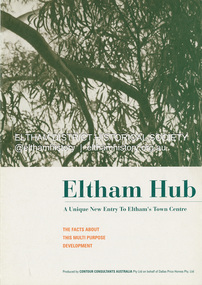
Document - Sales Brochure, Dallas Price Homes Pty Ltd, Eltham Hub: A Unique New Entry To Eltham's Town Centre; the facts about this multi purpose development, 1996
... Produced by Contour Consultants Australia Pty Ltd on behalf of Dallas Price Homes Pty Ltd as part of the planning process for redevelopment of the former Eltham Shire Office site at 895 Main Road. ......Contour Consultants Australia Pty Ltd...Eltham District Historical Society Inc 728 Main Rd Eltham melbourne Produced by Contour Consultants Australia Pty Ltd on behalf of Dallas Price Homes Pty Ltd as part of the planning process for redevelopment of the former Eltham Shire Office site at 895 Main Road. ...Produced by Contour Consultants Australia Pty Ltd on behalf of Dallas Price Homes Pty Ltd as part of the planning process for redevelopment of the former Eltham Shire Office site at 895 Main Road. In 1963 the Shire of Eltham purchased the Shillinglaw property of approximately 2 acres in Main Road, Eltham for the widening of Main Road and as a site for new Council offices. This land, which contained the Shillinglaw Cottage (c1878-80), was the remaining section of the Shillinglaw family holding that originally comprised 30 acres, being Lot 90 of Holloway's 1851 subdivision. Eltham Council intended to demolish this cottage, but through extensive community action it was saved, funds were raised, and it was relocated to the current site adjacent to the Eltham Library. The new Eltham Shire Offices opened in 1965 were designed to ensure retention of the three Italian Cypress trees that were located outside the Shillinglaw Cottage. In 1971 the building was extended at the southern end to provide additional space, including for the Eltham Library and Council's Engineering Department. Renovations were undertaken to the offices during 1987. The Victorian State Government commenced to restructure local government in 1994, which resulted in the establishment of the Shire of Nillumbik and the cessation of the Shire of Eltham. This new Nillumbik Shire Council was headed by government appointed commissioners, who decided in 1995 to put the former Eltham Shire offices on the market. Eventually in June 1996 the property was sold for $1.1 million and the building was subsequently demolished. A planning application for the site was then submitted to Nillumbik Shire Council in September 1996 for construction of a 24-hour service station, convenience store, cafe/takeaway food premises, a retail facility and community facility. There were many objections to this proposed development and in controversial circumstances a planning permit was granted by the Nillumbik Shire Council commissioners. After protracted actions involving a planning panel and a planning advisory committee, established by the Minister for Local Government, the proposal was eventually rejected as not satisfying the requirements of the planning scheme. In December 1997 the purchaser withdrew from the contract of sale, just prior to Council announcing a withdrawal from the contract. While there have been a number of possible development proposals considered by subsequent Nillumbik Shire Councils, this site has remained vacant since July 1996. TIMELINE (Prepared by Jim Connor, Eltham District Historical Society- March 2018- Based on press, council and personal records) June 1996 - Eltham Shire offices sold to Dallas Price Homes for $1.1 million. July 1996 - Shire office building demolished against community's wishes. Council claimed building riddled with asbestos. September 1996 - Planning application submitted to Nillumbik Shire Council to construct on the site a 24 hours Shell service station, convenience store, Hungry Jacks café/takeaway food premises, a retail facility and community facility. 213 objections and petition of over 1400 signatures received. Minister for Planning and Local Government orders an independent investigation into valuation and sale. 9 October 1996 - Permit granted by Nillumbik Shire Council commissioners, in controversial circumstances. A Planning Special Committee consisting of 3 commissioners and 3 community representatives considered 32 community objections. One commissioner declared a potential conflict of interest so only 2 commissioners were able to vote. After hearing all objections, the community representatives moved a foreshadowed motion to refuse a permit. The commissioners then closed the meeting, formerly opened a council meeting (for about a minute) and approved the application. October 1996 - Community members appealed planning decision to Administrative Appeals Tribunal. November 1996 -Minister for Planning and Local Government Robert McClelland calls appeal in and directs MT to refer this 'major policy issue' to the Governor in Council. February 1997 - Planning panel (Dimity Reed and Margaret Pitt) established to consider submissions. March 1997 - New council elected with five councillors. April 1997 - Three of the five new councillors vote to fight Commissioner's decision to grant a permit. April 1997 - Planning panel (Dimity Reed and Margaret Pitt) conducts hearings at Nillumbik Shire offices. June 1997 -Planning panel rejected Dallas Price Homes proposal as being 'totally inappropriate' for the site and recommends the site be rezoned for 'public purposes'. July 1997 - Dallas Price Homes threatened to sue Council and individual councillors. October 1997 - Report released of an Advisory Committee (Paul Jerome) established by the Minister for Planning and Local Government. Committee considered Dallas Price Homes proposal and an alternative concept plan proposal by Council for a gallery, workshop, offices and cinema community-based development. Advisory Committee recommended Dallas Price Homes proposal be rejected as not satisfying the requirements of the planning scheme and recommended further testing of the financial viability of Council's proposal. December 1997 - Dallas Price Homes withdrew from the contract of sale, just prior to Council announcing a withdrawal from the contract, which expired on 28th November and was not renewed by either side, after previously being extended twice pending a decision by the Minister. Council had to pay developer $58,000 for demolition costs. February 1998 - Dallas Price Homes application rejected by Planning and Local Government Minister. October 1998 - Nillumbik Councillors suspended and an Administrator appointed (until March 1999). The demolition of the former Shire of Eltham offices and proposed sale and development driven by the Commissioners for Nillumbik Shire Council brought the community together in substantial protest at the infrigement of ratepayers democratic say in local government and ciommunity assets combined with protests about inappropraite development of Eltham's Gateway. This issue led to the formation of the Eltham Community Action Group which still operates strongly today (2023) on behalf of the community to ensure appropriate development within the community.895 main road, commissioners, dallas price homes, development application, eltham hub, hungry jacks, nillumbik shire council, re-zoning, shell service station, town planning, eltham gateway, eltham gateway action group, eltham shire offices, shillinglaw cottage, shillinglaw farm, shillinglaw trees, jim connor collection -
Whitehorse Historical Society Inc.
Map, Dandenong Ranges Area, 1955
... Scale 10 chains : 1 inch. Contours marked....Scale 10 chains : 1 inch. Contours marked....Scale 10 chains : 1 inch. Contours marked. Maps Vermont South Wantirna Dandenong Creek Sheet 13. ...Sheet 13. Parts of Parishes: Nunawading, Mulgrave and Scoresby.Sheet 13. Parts of Parishes: Nunawading, Mulgrave and Scoresby. Includes area of Vermont South marked as proposed Township of Norwich. Scale 10 chains : 1 inch. Contours marked.Sheet 13. Parts of Parishes: Nunawading, Mulgrave and Scoresby. maps, vermont south, wantirna, dandenong creek -
 Kew Historical Society Inc
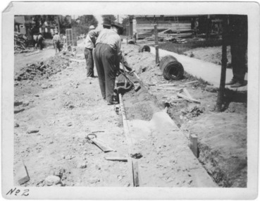
Photograph - Instructional photograph No.2: Using concrete for street kerbs, Portland Cement Association, 1921
... "2nd - Tamping Concrete into Approximate Contour"...The photos demonstrate knowledge about and the use of concrete in street works in a major Melbourne municipality at an early period. street works kerbing gutters concrete portland cement association "2nd - Tamping Concrete into Approximate Contour" Black and white photograph with printed instructions on the reverse showing the production of concrete kerbing on 67th Street, West Allis, Milwaukee, Wisconsin (USA). ...One of seven photographs produced by the Portland Cement Association in 1921 showing how concrete kerbs could be created. Portland Cement Association (PCA) was founded in 1916. From 1917, the association actively promoted the benefits of concrete for road works in Australian newspapers. In the nineteenth century in Melbourne (Vic.) 'made roads' typically had gutters and kerbing lined with bluestone.The photographs are important evidence of the availability of instructional models for the use of concrete in street works in Victoria. While the photographs date from the early 1920s, the use of concrete for kerbing did not reach its maturity until after World War 2. The photos demonstrate knowledge about and the use of concrete in street works in a major Melbourne municipality at an early period.Black and white photograph with printed instructions on the reverse showing the production of concrete kerbing on 67th Street, West Allis, Milwaukee, Wisconsin (USA). The photograph was produced by the Portland Cement Association of Chicago in 1921 and used within the Chief Engineer's Department of the City of Kew (Vic.)."2nd - Tamping Concrete into Approximate Contour"street works, kerbing, gutters, concrete, portland cement association -
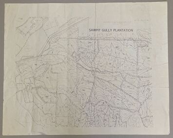 Creswick Campus Historical Collection - University of Melbourne
Map - Sawpit Gully Plantation showing plantation lots up to 1976, Sawpit Gully Plantation W.B.P No. 304
... Printed map, contours at 25 ft....Creswick Campus Historical Collection - University of Melbourne 4 Water Street University of Melbourne Creswick Campus Building 719/718 Creswick goldfields Printed map, contours at 25 ft. Sawpit Gully Plantation W.B.P No. 304 Map Sawpit Gully Plantation showing plantation lots up to 1976 ...Printed map, contours at 25 ft. -
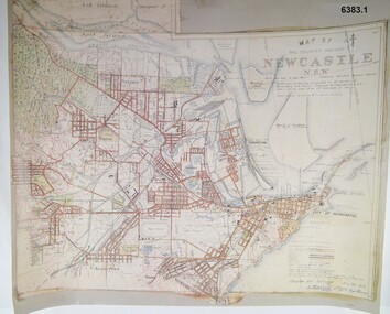 Bendigo Military Museum
Map - Map of Newcastle NSW 4 Inch - 1 Mile 1910, Australian Intelligence Corps, Nov 1910
... It was unique because it was now produced on an accurate gridded base and included contouring. Lynch and Davies transferred to the Royal Australian Engineers (RAE) whilst Barrett and Wilcox returned to the UK in June 1913. ...A gridded Map of Newcastle NSW area scale four inches to one mile with 25 feet interval contouring. Coloured hand drawn map produced in 1910. ...It was unique because it was now produced on an accurate gridded base and included contouring. Lynch and Davies transferred to the Royal Australian Engineers (RAE) whilst Barrett and Wilcox returned to the UK in June 1913. ...In 1909 the Australian Army Headquarters realized that mapping in Australia was either non existent or inadequate for Military use. It was requested that Australia borrow Survey personnel from the UK Royal Engineers (RE) for a two-year detachment. On 11 April 1910 four RE NCOs arrived in Melbourne comprising CPL J Lynch, and LCPLs AH Barrett, EF Davies and R Wilcox. LCPL Barrett had 12yrs experience with RE. They were aiming at producing eight map sheets per year covering about 7,000 square miles (18,000 square Km) This map sheet of the Newcastle area was produced using plane table methods and was surveyed and hand drawn by LCPL A Barrett Oct - Nov 2010. It was unique because it was now produced on an accurate gridded base and included contouring. Lynch and Davies transferred to the Royal Australian Engineers (RAE) whilst Barrett and Wilcox returned to the UK in June 1913. Barrett returned to Australia in 1915 and also enlisted in the RAE and served until 1919.A gridded Map of Newcastle NSW area scale four inches to one mile with 25 feet interval contouring. Coloured hand drawn map produced in 1910. Signed by " A Barrett LCPL Royal Engineers"royal australian survey corps, rasvy, fortuna, army svy regt, army survey regiment -
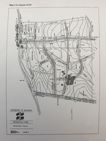 Federation University Historical Collection
Plan, Ballarat Technology Park plans, c1998
... .1) Alotment plan .2) contour plan...Barker Library (top floor) Mount Helen goldfields ballarat technology park mount helen campus canadian wetlands ballarat to buninyong railway line sub-division layout .1) Alotment plan .2) contour plan Ballarat Technology Park plans Plan ....1) Alotment plan .2) contour planballarat technology park, mount helen campus, canadian wetlands, ballarat to buninyong railway line, sub-division layout -
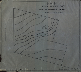 Federation University Historical Collection
Plan, SMB Block at White Flat
... Plan of contours at White Flat, Ballarat Central. ...white flat ballarat school of mines ballarat central Plan of contours at White Flat, Ballarat Central. SMB Block at White Flat Plan Plan ...Plan of contours at White Flat, Ballarat Central. white flat, ballarat school of mines, ballarat central -
 Federation University Historical Collection
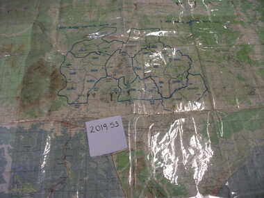
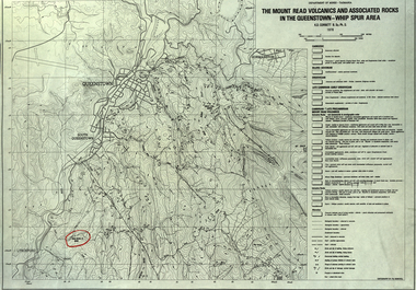
Map, The Mount Read Volcanics and Associated Rocks in the Queenstown - Whip Spur Area, 1978, 1978
... Contour map of the Queenstown area in Tasmania, Australia....department of mines tasmania volcanics mount read queesntown whip spur mining king river gormanston mt owen lynchford Contour map of the Queenstown area in Tasmania, Australia. ...Contour map of the Queenstown area in Tasmania, Australia.department of mines tasmania, volcanics, mount read, queesntown, whip spur, mining, king river, gormanston, mt owen, lynchford -
 Greensborough Historical Society
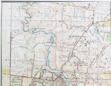
Map, John Monash, 1913 Map of Greensborough, 1913
... Colour map showing land contours and place names...Greensborough - maps 1913 Colour map showing land contours and place names 1913 Map of Greensborough Map Map John Monash ...1913 Map of Greensborough, possibly by John Monash. This map shows the area to the north of the township.Colour map showing land contours and place namesgreensborough - maps, 1913 -
 Bendigo Military Museum
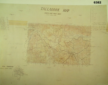
Map - Australian Topographical Survey TALLAROOK SE Sheet, 1 inch:1 Mile, NW portion Plane Table Field sheet 1923, Australian Survey Corps, 1923
... Of particular interest is the fact that this is a heighted compilation with contouring (required for Military use) as many early maps were purely planimetric. ...Reprinted coloured Image of Australian Topographical Survey TALLAROOK SE field Sheet,1 inch:1 Mile, hand drawn contoured Plane Table Field sheet. Signed by Sgt J Cullen Australian Survey Corps November1923. ...Of particular interest is the fact that this is a heighted compilation with contouring (required for Military use) as many early maps were purely planimetric. ...This is a coloured reproduction print of an original Plane Table compilation map sheet of Tallarook area 1inch to 1 Mile scale compiled by Sgt Jack Cullen Australian Survey Corps 12 November 1923 and signed by Capt J Lynch. Capt Lynch and Sgt Cullen were both foundation members of the Australian Survey Corps. Of particular interest is the fact that this is a heighted compilation with contouring (required for Military use) as many early maps were purely planimetric. The reverse side of this print is a copy of the Nagambie plane table South West field sheet.Reprinted coloured Image of Australian Topographical Survey TALLAROOK SE field Sheet,1 inch:1 Mile, hand drawn contoured Plane Table Field sheet. Signed by Sgt J Cullen Australian Survey Corps November1923. An enlargement of YEA Township 2 Inches to 1 Mile Scale.royal australian survey corps, rasvy, fortuna, army survey regiment, army svy regt, asr -
 B-24 Liberator Memorial Restoration Australia Inc
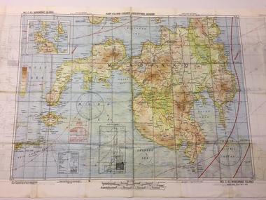
Map - US World War II-coloured map, - Southwest Pacific Area, No.22 Southwestern, No.26 East Java, No.25 Timor, 1943
... A multi-coloured, contoured, double-sided map printed on acetate rayon ...This map, printed on acetate rayon, is an original US 'escape and evasion' kit map from World War II. world war ii silk maps united states of america a188 AAF Cloth Map - Southwest Pacific Area Side 1 - No. 22 Southwestern and No. 26 East Java Side 2 - No. 25 Timor A multi-coloured, contoured, double-sided map printed on acetate rayon Map US World War II-coloured map, - Southwest Pacific Area, No.22 Southwestern, No.26 East Java, No.25 Timor ...Silk and rayon maps were produced by the United States (c. 7.5 million in total), Great Britain (some 1.75 million in total) and Australia during World War II. They were issued to Allied military personnel as part of 'escape and evasion' kits.This map, printed on acetate rayon, is an original US 'escape and evasion' kit map from World War II.A multi-coloured, contoured, double-sided map printed on acetate rayon AAF Cloth Map - Southwest Pacific Area Side 1 - No. 22 Southwestern and No. 26 East Java Side 2 - No. 25 Timorworld war ii, silk maps, united states of america, a188 -
 B-24 Liberator Memorial Restoration Australia Inc
Map - US World War II multi-coloured map - Philippine Series, No. C-43 Mindanao Series, No. C-44 North Borneo, 1944
... A multi-coloured, contoured, double-sided map printed on acetate rayon ...C.44 North Borneo A multi-coloured, contoured, double-sided map printed on acetate rayon Map US World War II multi-coloured map - Philippine Series, No. ...Silk and rayon maps were produced by the United States (c. 7.5 million in total), Great Britain (some 1.75 million in total) and Australia during World War II. They were issued to Allied military personnel as part of 'escape and evasion' kits.This map, printed on acetate rayon, is an original US 'escape and evasion' kit map from World War II.A multi-coloured, contoured, double-sided map printed on acetate rayon AAF Cloth Chart - Philippine Series Side 1 - No. C-43 Mindanao Series Side 2 - No. C.44 North Borneounited states of america, silk and rayon maps, world war ii -
 B-24 Liberator Memorial Restoration Australia Inc
Map - US World War II multi-coloured map, Side 1 - No. C-47 South Borneo, Side 2 - No. C-48 West Java, 1944
... A multi-coloured, contoured, double-sided map printed on acetate rayon ...C.48 West Java A multi-coloured, contoured, double-sided map printed on acetate rayon Map US World War II multi-coloured map, Side 1 - No. ...Silk and rayon maps were produced by the United States (c. 7.5 million in total), Great Britain (some 1.75 million in total) and Australia during World War II. They were issued to Allied military personnel as part of 'escape and evasion' kits.This map, printed on acetate rayon, is an original US 'escape and evasion' kit map from World War II.A multi-coloured, contoured, double-sided map printed on acetate rayon AAF Cloth Chart Side 1 - No. C-47 South Borneo Side 2 - No. C.48 West Javaunited states of america, silk and rayon maps, world war ii, a191 -
 B-24 Liberator Memorial Restoration Australia Inc
Map - US World War II multi-coloured map- Southwest Pacific Area, No. 23 North Celebes, No. 24 South Celebes, 1942-1943
... A multi-coloured, contoured, double-sided map printed on acetate rayon ...This map, printed on acetate rayon, is an original US 'escape and evasion' kit map from World War II. world war ii silk maps united states of america a189 AAF Cloth Map - Southwest Pacific Area Side 1 - No. 23 North Celebes Side 2 - No. 24 South Celebes A multi-coloured, contoured, double-sided map printed on acetate rayon Map US World War II multi-coloured map- Southwest Pacific Area, No. 23 North Celebes, No. 24 South Celebes ...Silk and rayon maps were produced by the United States (c. 7.5 million in total), Great Britain (some 1.75 million in total) and Australia during World War II. They were issued to Allied military personnel as part of 'escape and evasion' kits.This map, printed on acetate rayon, is an original US 'escape and evasion' kit map from World War II.A multi-coloured, contoured, double-sided map printed on acetate rayon AAF Cloth Map - Southwest Pacific Area Side 1 - No. 23 North Celebes Side 2 - No. 24 South Celebesworld war ii, silk maps, united states of america, a189 -
 Bendigo Historical Society Inc.
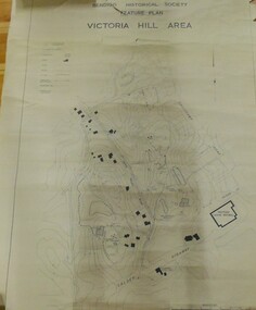
Map - VICTORIA HILL AREA
... Contour plan of the Victoria Hill area, with all of the historical features marked and named...CMF increment May 1971 Contour plan of the Victoria Hill area, with all of the historical features marked and named Map VICTORIA HILL AREA ...Contour plan of the Victoria Hill area, with all of the historical features marked and namedCompiled by AHQ Survey Regt. CMF increment May 1971map, reserves, mining, bendigo goldfield, victoria hill -
 Federation University Historical Collection
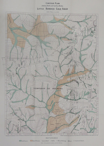
Map - Report, H.S. Whitelaw, Report on the Little Bendigo or Nerrina Gold-Field, Ballarat, 1901, 1901
... Blue soft covered book. Includes Contour plan of the Little Bendigo Goldfield...Barker Library (top floor) Mount Helen goldfields little bendigo nerrena nerrina h.s. whitelaw Blue soft covered book. Includes Contour plan of the Little Bendigo Goldfield Report on the Little Bendigo or Nerrina Gold-Field, Ballarat, 1901 Map Report H.S. ...Blue soft covered book. Includes Contour plan of the Little Bendigo Goldfieldlittle bendigo, nerrena, nerrina, h.s. whitelaw -
Federation University Historical Collection
Architectural Drawing, Ballarat School of Mines Mount Helen Development, c1967
... Architectural Drawing for the Mount Helen campus. Contour plan of Mt Helen campus....mount helen campus ballarat college of advanced education l.h. vernon and associates building f building g Architectural Drawing for the Mount Helen campus. Contour plan of Mt Helen campus. Ballarat School of Mines Mount Helen Development Architectural Drawing L.H. ...Architectural Drawing for the Mount Helen campus. Contour plan of Mt Helen campus.mount helen campus, ballarat college of advanced education, l.h. vernon and associates, building f, building g -
 B-24 Liberator Memorial Restoration Australia Inc
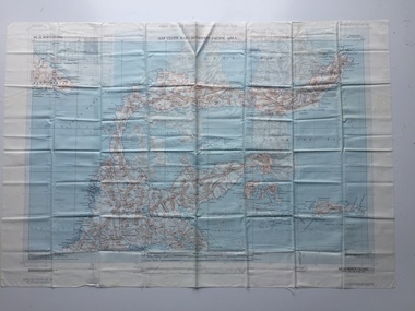
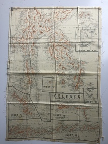
Map - Australian World War II silk map of Celebes, 1940s
... An oblong, cream colour, single-sided map printed in black and white with brown contours, Celebes ...This silk map, one of relatively few produced in Australia (most Australian RAAF pilots and crew were issued with British and US maps), is an original map from World War II. world war ii silk maps australia a185 'Prepared under the direction of RAAF Headquarters' Celebes (with Insets 'A' to 'E') An oblong, cream colour, single-sided map printed in black and white with brown contours, Celebes Map Australian World War II silk map of Celebes ...Silk and rayon maps were produced by Australia, Great Britain (some 1.75 million in total) and the United States (c.7.5 million) during World War II. They were issued to Allied military personnel as part of 'escape and evasion' kits.This silk map, one of relatively few produced in Australia (most Australian RAAF pilots and crew were issued with British and US maps), is an original map from World War II.An oblong, cream colour, single-sided map printed in black and white with brown contours, Celebes 'Prepared under the direction of RAAF Headquarters' Celebes (with Insets 'A' to 'E')world war ii, silk maps, australia, a185