Showing 573 items matching " house in grant street"
-
 Linton and District Historical Society Inc
Photograph, The Downing children, c.1906
... ... House in Grant Street...The house in the photograph, in Grant Street, Linton, was afterwards lived in by Linton doctor and local identity Dr James Blair Donaldson Snr....Downing family Thomas Frederick Downing Frederick (Fred) Downing Gladys Downing Lillian Downing Doris Downing House in Grant Street "Downing family house on hill behind Dr Donaldson's Mr Downing engine driver". ...The Downing family lived in Linton for two periods - the first, from about 1902 to 1907, and the second from about 1908 to 1910. Thomas Frederick Downing, born 1865, worked from 1890 as a fireman with the Victorian Railways. Five of the seven Downing children became teachers. The house in the photograph, in Grant Street, Linton, was afterwards lived in by Linton doctor and local identity Dr James Blair Donaldson Snr.Sepia photograph of three young girls and a boy standing in the gateway at front of a house."Downing family house on hill behind Dr Donaldson's Mr Downing engine driver".downing family, thomas frederick downing, frederick (fred) downing, gladys downing, lillian downing, doris downing, house in grant street -
 Federation University Historical Collection
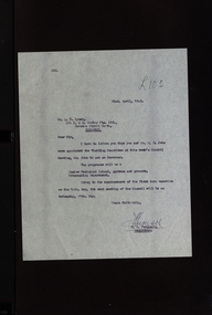
Correspondence - Education Department, Victoria, SMB: Purchase of properties in Grant Street, 1951
... Correspondence between the Education Department and Ballarat School of Mines and Industries in relation to the purchase of houses in Grant Street Ballarat. The acquisition of these properties would allow for the expansion of the School of Mines....Barker Library (top floor) Mount Helen goldfields Correspondence between the Education Department and Ballarat School of Mines and Industries in relation to the purchase of houses in Grant Street Ballarat. The acquisition of these properties would allow for the expansion of the School of Mines. ballarat school of mines education department of victoria grant street ballarat properties SMB: Purchase of properties in Grant Street Correspondence - Education Department, Victoria ...Correspondence between the Education Department and Ballarat School of Mines and Industries in relation to the purchase of houses in Grant Street Ballarat. The acquisition of these properties would allow for the expansion of the School of Mines.ballarat school of mines, education department of victoria, grant street, ballarat, properties -
 Federation University Historical Collection
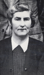
Article - Article - Women, Ballarat Technical Art School: Women of Note; Mary Fogarty, teacher Arts and Crafts.(1910-1981)
... As the school grew they were given space in the Art School. Houses along Grant Street were bought with the intention of building a three storey building. ...As the school grew they were given space in the Art School. Houses along Grant Street were bought with the intention of building a three storey building. ...Mary Fogarty was a student at the School of Mines in the 1920s. She was a member of the Hockey team that was part of the Ballarat Hockey Association Competition. She studied Arts and Crafts and became a teacher at the SMB Technical Arts School. In 1945 she was in charge of the Girls' Preparatory Classes - Years 7 and 8. In 1950 she was asked to start the Technical School for Girls. !951 saw 30 Form 1 students in the ground floor of the old SMB Secondary School (E J Tippett Library/former Gaol Governor's residence). She had an assistant. 1952 saw another 30 students enrolled and two more staff. As the school grew they were given space in the Art School. Houses along Grant Street were bought with the intention of building a three storey building. The girls had Art with Art School Staff, Science in SMB Science Room and Music women of note, teacher, ballarat school of mines, smb campus, mary fogarty, student, hockey team, arts and crafts, technical arts school, girls' preparatory classes, technical school for girls, ballarat girls' technical school -
 Bendigo Military Museum
Legal record - CONSTITUTION, BENDIGO RSL, 1) .2) C. 1952. .3) C.1956
... Street Bendigo with the title dated 9.2.1951, the facility opened on 1.6.1951 but without a Liqueur Licence. Years followed with a failure to be granted one. Finally the facility was sold to Bendigo Legacy and they occupied the building on 7.6.1959 which became known as "Legacy House". ...Street Bendigo with the title dated 9.2.1951, the facility opened on 1.6.1951 but without a Liqueur Licence. Years followed with a failure to be granted one. Finally the facility was sold to Bendigo Legacy and they occupied the building on 7.6.1959 which became known as "Legacy House". ...These Constitutions dated 14.11.1952 with the name's , "A.V. Palmer - President" (Bendigo RSL) "N.D. Wilson - President - Vic Branch R.S.S.A.I.L.A". The small booklets were headed "Rules of the Bendigo Returned Servicemen's Club - 1956" As far back as 1950 there was discussion within the Sub Branch re a Club in suitable premises. A property was purchased being 11 McKenzie Street Bendigo with the title dated 9.2.1951, the facility opened on 1.6.1951 but without a Liqueur Licence. Years followed with a failure to be granted one. Finally the facility was sold to Bendigo Legacy and they occupied the building on 7.6.1959 which became known as "Legacy House". This is a very brief version of the events from the Book by Murray Poustie, refer Cat No 8093, The history of the Bendigo RSL. .3) The Rules of the Welfare Committee were in .1) folded in half. There is 6 paragraphs with a total of 18 Clause's..1) Folder cardboard covers light brown colour with taped binding, cover has typed black heading underlined in red, hand written notes in black pen added, 15 typed pages in black stapled inside with a hand written note in black written on one page. Inside the front cover stapled in is a small grey booklet with 24 pages in black text. .2) Same as .1) but without any hand written notes. .3) Two pages stapled together typed in black re "Welfare Rules".1) .2) Typed text on covers underlined, " Constitution - Bendigo - Returned Sailors Soldiers and Airmen's Imperial League of Australia". Hand written on .1) "Do not take this out of Office - See change of Constitution paragraph 25 Clause 1". .3) Heading, Rules for the Conduct of Welfare Committee"brsl, legal, smirsl -
 Victoria Police Museum
Police Stations (Alexandra)
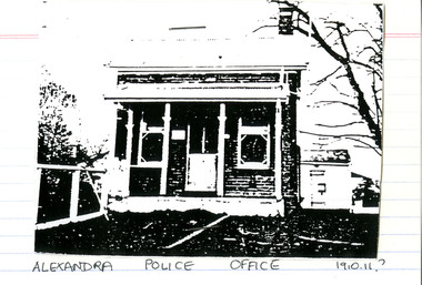
... Grant Street. When the station opened it was staffed by one Senior Constable; one 1st Constable (Mounted); one Foot Constable. The original building was a nine-roomed brick building with an iron roof on land measuring 84' x 97’. The house...Grant Street. When the station opened it was staffed by one Senior Constable; one 1st Constable (Mounted); one Foot Constable. The original building was a nine-roomed brick building with an iron roof on land measuring 84' x 97’. The house ...Alexandra is a regional centre in the Shire of Murrindindi in Victoria, Australia and 130 kilometres north east of Melbourne. Alexandra Police Station opened in the Benalla Police District on 8 May 1867 in Bon Street, on the north side near Grant Street. When the station opened it was staffed by one Senior Constable; one 1st Constable (Mounted); one Foot Constable. The original building was a nine-roomed brick building with an iron roof on land measuring 84' x 97’. The house included a wash-house, pantry, bathroom, office, one W.C., stabling for three horses, a lock-up with two rooms and a single man's room. It closed in June 1977 and was replaced by a new police station which opened on 16 June 1977 in Bon Street, on land adjacent to the old police station. For a list of Officers in Charge 1871 to 1943 contact Victoria Police Museum1 black and white photo and 3 colour photospolice stations; alexandra police station -
 Federation University Historical Collection
Document - Document - Research Paper, University of Ballarat: Applied Social and Political Research; "What has been the History of Lisa Lodge-Haveslee from 1970 - 1980?" Beverlee Leith, 1994
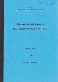
... granted at their meeting on Thursday, 11 August 1994. Dr John McDonald, School of Humanities and Social Sciences was supervisor. honorary probation officers ballarat adolescent girls hayeslee house minutes of meetings correspondence berry street interviews beverlee leith human research ethics committee school of humanities & social sciences dr john mcdonald lisa lodge girls' hostel residential care Name John McDonald written in biro - top right corner of front cover. ...Lisa Lodge Girls' Hostel, Ballarat, was established in 1970 and was run by a committee of women. All the women were Honorary Probation Officers. It provided residential care for eight adolescent girls at a time. Lisa Lodge was located in a number of different properties around Ballarat. The Hostel closed in 1994. Some time after this, Hayeslee House (another home in Ballarat, run by the same committee) became known as Lisa Lodge. This Committee managed a number of institutions in the Ballarat region. Another institution to start in 1994 was Berry Street Incorporated that amalgamated with Sutherland Child, Youth and Family Services. In 2009 Berry Street was the largest independent child and family welfare organisation in Victoria. In 2012 Lisa Lodge merged with Berry Street to strengthen Berry Street's services provided in the Grampians Region of Victoria. This research paper explores the first ten years of Lisa Lodge. Of note is Lisa Lodge was set up by a group of women for a group of women. It depended on donations to continue operating. Data was collected through interviews and analysing minutes of meetings. Correspondence and newspaper clipping were also used. This is a historical report so there are no recommendations. Before proceeding with this project, Beverlee Leith had to seek approval from the Human Research Ethics Committee, University of Ballarat. This was granted at their meeting on Thursday, 11 August 1994. Dr John McDonald, School of Humanities and Social Sciences was supervisor.Booklet of 51 pages. Blue paper cover front and back. Pages are glued together and have black binding. Name John McDonald written in biro - top right corner of front cover. Date of item is 1994honorary probation officers, ballarat, adolescent girls, hayeslee house, minutes of meetings, correspondence, berry street, interviews, beverlee leith, human research ethics committee, school of humanities & social sciences, dr john mcdonald, lisa lodge girls' hostel, residential care -
 Orbost & District Historical Society
book, The Village School, September 1990
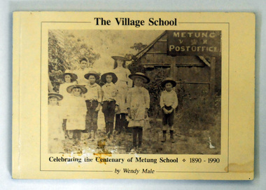
... Street Orbost gippsland The book was written as part of the centenary celebrations of the Metung School. This book is a useful reference for the history of Metung and education in the East Gippsland area. Metung-history education-East Gippsland A 116 pp book titled The Village School. with a b/w photograph of children standing outside a building in 1890. The building is Metung's first school and post office at George Grant's house ...The book was written as part of the centenary celebrations of the Metung School.This book is a useful reference for the history of Metung and education in the East Gippsland area.A 116 pp book titled The Village School. with a b/w photograph of children standing outside a building in 1890. The building is Metung's first school and post office at George Grant's house an Shaving Point. The title and "Celebrating the centenary of Metung School 1890-1990 is in black . The book was written by Wendy L. Male of Metung.metung-history education-east gippsland -
 Eltham District Historical Society Inc
Document - Folder, North, Edley
... He was granted an allotment of 221 acres on Phillip Island 1868-1870. on 7 April 1874 he travelled to Pine Lodge and later moved his wife and five children. He and Caroline later moved to a small farm, Willow Grove in Eltham, purchased between 1905 and 1910 (first mentioned in the rate book in 1908 as being a house and 10 acres on Susan Street, and would also have had frontage on Brougham Street); Their daughter Violet Alice inherited it; she married Walter J Dobson around 1921; he died on 25 March 1948 aged 77 and Violet on 4 January 1947. ...He was granted an allotment of 221 acres on Phillip Island 1868-1870. on 7 April 1874 he travelled to Pine Lodge and later moved his wife and five children. He and Caroline later moved to a small farm, Willow Grove in Eltham, purchased between 1905 and 1910 (first mentioned in the rate book in 1908 as being a house and 10 acres on Susan Street, and would also have had frontage on Brougham Street); Their daughter Violet Alice inherited it; she married Walter J Dobson around 1921; he died on 25 March 1948 aged 77 and Violet on 4 January 1947. ...Joseph Benjamin North was a well-known professional musician in Melbourne in late 1800 to mid 1900s, teaching music and playing in what became the Melbourne Symphony Orchestra. He married Lucinda Matilda and their children were Tralford E and Camille D. With friend Leon Lambert, North purchased 60 acres of land around Karingal Drive and Sherbourne Road and built two houses; they paid for a wooden bridge for access. North eventually sold his house to a family named Green but later the land was sold to the Shire of Eltham, and it is now known as Meruka Park, and the house, Meruka House; Alan Gardner named the park. After Lambert's death, his property was bought by Fred Warne. Edley North was born in 1835, and died 26 March 1923; he married Caroline North, born 1835, died 23 July 1922. Edley's family migrated from England in 1859, settling in Adelaide. He was granted an allotment of 221 acres on Phillip Island 1868-1870. on 7 April 1874 he travelled to Pine Lodge and later moved his wife and five children. He and Caroline later moved to a small farm, Willow Grove in Eltham, purchased between 1905 and 1910 (first mentioned in the rate book in 1908 as being a house and 10 acres on Susan Street, and would also have had frontage on Brougham Street); Their daughter Violet Alice inherited it; she married Walter J Dobson around 1921; he died on 25 March 1948 aged 77 and Violet on 4 January 1947. Willow Grove was later purchased by A George and P Audrey Hester April/May 1947. Edley, Caroline and Violet are all buried in Eltham Cemetery. Marjorie Mary North was born in 1909 ; the family travelled in a horse-drawn waggon from Fitzroy to spend weekends in their little holiday house in Sherbourne Road on 10 acres of land. In 1933, she married Tralford Norman whose parents owned 62 acres of land including Meruka Park. Marjorie and Tralford lived in Looker Road, Montmorency; she died 7 February 2003. Contents Newspaper article: "When life centred on a weekender", Diamond Valley News, 25 September 1984, memories of Montmorency of Marjorie North. Newspaper article: "Worse floods seem likely", Diamond Valley News, 25 September 1984, floods in Eltham Handwritten notes: Information by Marjorie North's about her grandmother, September 1989. Handwritten and typed transcript: "J. B. North", by Marjorie North, history of Joseph Benjamin North. Letter: From Monash University to Marjorie North, 15 November 1989, being unable to assist with her enquiry about the meaning of name [unspecified in the letter but possibly Meruka] Letter: June Stanton (nee Hester) to Eltham District Historical Society, 17 February 1993, seeking information on her great grandfather Edley North and wife Caroline. Christmas card [attached to letter from June Stanton]: Line drawing Eltham Primary School 1856, text history of school Letter: Eltham Historical Society to June Hester, 11 June 1993, providing information held by the Society. Letter: Nancy Chandler (nee Williamson) to Jo McCormick 18 March 2001, providing information about Edley and Carline North, her great grandparents. Email: Patsy Moppett to Eltham District Historical Society October 2010: A photograph of Edley and Caroline North found, wish to return it to family. Family tree: North/Dobson family. Death notice: Marjorie May North, died 7 February 2003.Newspaper clippings, A4 photocopies, etcmarjorie north, tralford norman, sherbourne road montmorency, looker road montmorency, briar hill, montmorency, catholic ladies college, merton hall, melbourne girls grammar school, ivanhoe girls grammar school, wesley college, meruka park, st helena road, st faith's anglican church montmorency, william sapsford, floods in eltham, joseph benjamin north, leon lambert, melbourne symphony orchestra, karingal drive, meruka house, alan gardner, lucinda matilda north, tralford e north, camille d north, montmorency cricket club, diamond creek, eltham railway station, judge book village, fred warne, edley north, caroline north, eltham cemetery., violet alice dobson (nee north), willow farm eltham, edley north family tree, walter john dobson family tree, nancy chandler (nee williamson), pine lodge, elijah north -
 Eltham District Historical Society Inc
Photograph - Digital Photograph, Alan King, Diamond Creek, Barak Bushlands, Eltham, 2008
... Street Reserve2 and 35 families joined from the 90-house Estate. Carolyn Mellor, as the Friends’ Land Manager, undertook a four-year horticulture course to guide this massive project for a volunteer organisation. Since 1999, she has been the Friends’ President. In 1999 the Friends urged the Nillumbik Council to undertake a feasibility study into establishing a wetland system and urban forest. Work began in 2002 with Nillumbik Council funding the project, supplemented by government grants...Street Reserve2 and 35 families joined from the 90-house Estate. Carolyn Mellor, as the Friends’ Land Manager, undertook a four-year horticulture course to guide this massive project for a volunteer organisation. Since 1999, she has been the Friends’ President. In 1999 the Friends urged the Nillumbik Council to undertake a feasibility study into establishing a wetland system and urban forest. Work began in 2002 with Nillumbik Council funding the project, supplemented by government grants ...A habitat corridor and it strengthens the community. Published: Nillumbik Now and Then / Marguerite Marshall 2008; photographs Alan King with Marguerite Marshall.; p185 Barak Bushlands lie west of the Diamond Creek on the corner of Falkiner Street and busy, noisy Main Road. They form part of an important habitat corridor linking the Yarra River to the Kinglake National Park.1 Manna Gums, tawny frogmouths and platypuses are some of the indigenous plants and animals that have made their home there. The bushlands are the result of more than nine years of hard work by the local community with the Nillumbik Council, to transform a degraded flood plain into this refuge of natural beauty. In 1997, shortly after moving into the new Riverside Estate on Falkiner Street, Eltham, several residents noticed the sorry state of the Diamond Creek and surrounding area. Part of it was used as a cow paddock and although small patches of vegetation survived, the area was infested with weeds, rabbits, rubbish and drainage from the housing estate. At various times the 4.4 hectares had been used as a market garden and for shire stock piles. The residents began to restore the area by revegetating land along the Diamond Creek. In 1998 they established the Friends of the Diamond Creek Falkiner Street Reserve2 and 35 families joined from the 90-house Estate. Carolyn Mellor, as the Friends’ Land Manager, undertook a four-year horticulture course to guide this massive project for a volunteer organisation. Since 1999, she has been the Friends’ President. In 1999 the Friends urged the Nillumbik Council to undertake a feasibility study into establishing a wetland system and urban forest. Work began in 2002 with Nillumbik Council funding the project, supplemented by government grants. The Friends also received grants from Melbourne Water and Parks Victoria. Aided by the Friends and other community members, the Council created the Barak Bushlands consisting of a forest, a wetland, a bridge, a path and open space. The beautiful wetland treats most of the estate’s stormwater runoff. Storm water is filtered through plants in the wetland ponds then is released slowly into the billabong, before flowing into the Diamond Creek. The wetland also helps to minimise flooding and the improved water quality provides a flora and fauna habitat. The Friends and other volunteers planted more than 27,000 plants, more than one third of which they grew from seeds they collected at Lower Eltham and Wingrove Parks. Eltham High School students planted thousands of these through a Year Eight program introduced for this purpose. Other groups who assisted were: Green Corps, local Scouts and Guides – 2nd Montmorency, 1st Diamond Creek and 1st Eltham Cub Packs, Eltham College students, Eltham East Primary School, Landcare members, Eltham Lions Club and the Eltham Baptist Church. To maintain enthusiasm for the mammoth task, the Friends and other volunteers ‘adopted’ trees to water and wrote their names on the stakes. In 2004, to recognise the area’s original occupiers, the reserve was named Barak Bushlands. William Barak, who lived from 1824 to 1903, was the last chief of the Yarra Yarra tribe of the Wurundjeri-willam people. Traces of these original inhabitants remain in scar trees (bark sections removed to make a shield or canoe). That same year the Friends’ group was a finalist in the prestigious Federal Government, Banksia Environmental Awards. The Friends have also participated in Clean Up Australia, removing tonnes of rubbish and regularly testing the billabong, wetland and creek, for pollutants. For years the Friends, together with the Australian Platypus Conservancy, have tagged, measured and checked the health of platypuses from the Diamond and Mullum Mullum Creeks. With Latrobe University the Friends have conducted night walks to view owls, possums, bats and sugar gliders. Challenges for the council and the Friends continue with a large rabbit population, some vandalism, weed eradication and maintenance. However, thanks to this community effort, locals can now escape confined urban living on small blocks of land and enjoy the beauty of indigenous plants and animals. Working together has also strengthened the local community,This collection of almost 130 photos about places and people within the Shire of Nillumbik, an urban and rural municipality in Melbourne's north, contributes to an understanding of the history of the Shire. Published in 2008 immediately prior to the Black Saturday bushfires of February 7, 2009, it documents sites that were impacted, and in some cases destroyed by the fires. It includes photographs taken especially for the publication, creating a unique time capsule representing the Shire in the early 21st century. It remains the most recent comprehenesive publication devoted to the Shire's history connecting local residents to the past. nillumbik now and then (marshall-king) collection, barak bushlands, diamond creek (creek), eltham -
 Eltham District Historical Society Inc
Photograph, J.H. Clark, Maria Street, Eltham, c.1910
... It is noted that the Grant of Probate for John H Clark of Eltham South dated 5 April 1957 (513/387) records his occupation as "X Photographer". main road eltham maria street dalton street william jarrold jarrold cottage police residence courthouse J.H. Clark Photo Notations in biro 'A. Petrie', rest in pencil as follows Telegraph poles show one wire No 1918 Avenue of Honour trees c.1907 Jarrolds house ...William Jarrold's cottage on left was used by the Police 1858-1860. The Court house and Police precinct (upper right) were opened in 1859-1860 Photographer: J.H. Clark John Henry Clark was the youngest of three boys born to William Henry Clark (1823-1877) and Maria White (1843-1914). He and his brothers, William Charles Clark (1872-1945), Clement Kent Clark (1874-1912) operated a photography business (Clark Bros.) from 25 Thomas Street, Windsor near Prahran during the period c.1894 to 1914. Following death of Clement in September 1912 and their mother in 1914, the Clark Bros business appears to have dissolved, the premises demolished, and a new house was under construction in 1915. John set up business independently in 1914 operating out of 29 Moor Street, Fitzroy where he is registered in the 1914 and 1915 Electoral Rolls. By 1916 John had relocated to Eltham where he continued his practice as a photographer and took many of the early images around the district of Little Eltham. Around 1930 John changed professions and opened a small cobbler's shop in 1931 near the pond opposite Dalton Street adjacent to the Jarrold family cottage. He never married and continued his profession as a bootmaker from this little shop, maintaining a close relationship with Mrs Jarrold for the rest of their lives. His bootmaker shop remains today beside the Whitecloud cottage and is one of only three remaining shops in the area from the early 20th century. There are a couple of images of Eltham taken by Clark Bros. in the Eltham District Historical Society collection, one such example being Hunniford’s Post Office with Miss Anne Hunniford out front (EDHS_00140 - marked on the back of the print, Clark Bros., 25 Thomas St. Windsor), which would date this image between c.1894 and 1914. Other early images of Eltham taken by John Henry Clark are marked on the face “J. H. Clark Photo” and it is assumed these are dated between 1914 and 1930. It is noted that the Grant of Probate for John H Clark of Eltham South dated 5 April 1957 (513/387) records his occupation as "X Photographer".Sepia postcardNotations in biro 'A. Petrie', rest in pencil as follows Telegraph poles show one wire No 1918 Avenue of Honour trees c.1907 Jarrolds house No shop at White Cloud on fence line Police Residence has extensions Chimney on wash house Office Brickwork on stables Lock-up, entry and window end Light lamp - cnr Dalton and Maria streets Surface damage to lower left cornermain road, eltham, maria street, dalton street, william jarrold, jarrold cottage, police residence, courthouse, j.h. clark photo -
Glen Eira Historical Society
Document - Historic Conservation Areas Project
... houses and architectural features. Historic Conservation Areas Project Niven Barbara Newsletters Town Planning Historic Buildings Heritage Studies Housing Royal Historical Society of Victoria (RHSV) Read Michael Plans Local Government Historical Societies Committee for Urban Action (CUA) National Trust Hopkins Sherry Ms. Ford Hazel Preliminary Conservation Survey Town Planning Heritage Studies Rodda Andrew City of Caulfield Housing Estates Victoria National Estate Grants Program Australia Icomos Burra Charter Buildings Structures and Establishments Land Surveys Suburbs Historic Buildings Architectural Significance ‘Caulfield’s Heritage Study’ Soloman Geulah Dr. Caulfield Library Dandenong Road Nepean Highway Hotham Street ...Contains 4 items relating to historic conservation: 1/Five newsletters (one page each newsletter, dated 07/1975, 08/1975, 09/1975, 10/1975 and the final one 12/1975) describing how the project evolved, project funds, progress, study method, project 1 report, project 2 report and summary as no further funds available. Project was to include all of Melbourne but funding did not allow this. Note: newsletters stamped with Caulfield Historical Society. 2/Letter (one page on official city of Caulfield letterhead) from Andrew Rodda (manager planning) to Hazal Ford (dated 13/11/1989) describing ‘council resolved on 18/07/1989 to proceed with preliminary conservation survey’ and mentions that a copy is included. 3/Preliminary conservation survey for the City of Caulfield (nine pages) describing background, study area, budget, purpose, study outline, timeframe, report format, ownership, tasks and background information (mentions number and types of houses and properties as at 1986 and 1988) and a map of City of Caulfield. 4/Booklet (28 pages) titled ‘Heritage Area – Caulfield North Draft Heritage Guidelines July 1999 – City of Glen Eira’, containing Caulfield North Heritage Area, cultural heritage, Heritage Overlay Area, architectural description, common architectural forms and features, development guidelines, key design checklist. It includes a map of the Caulfield North Heritage Overlay Area, two illustrations about the development envelope and many black-and-white photographs of houses and architectural features.historic conservation areas project niven barbara, newsletters, town planning, historic buildings, heritage studies, housing, royal historical society of victoria (rhsv), read michael, plans, local government, historical societies, committee for urban action (cua), national trust, hopkins sherry ms., ford hazel, preliminary conservation survey, town planning, heritage studies, rodda andrew, city of caulfield, housing estates, victoria national estate grants program, australia icomos, burra charter, buildings structures and establishments, land surveys, suburbs, historic buildings, architectural significance, ‘caulfield’s heritage study’, soloman geulah dr., caulfield library, dandenong road, nepean highway, hotham street, iknerman road, orrong road, north road, poath road, ‘plan of the city of caulfield’, north ward, east ward, south ward, west ward, kooyong road, neerim road, bambra road, balaclava road, shire of caulfield, railways, world war 1914-1918, depression 1929-1939, rippon lea, labassa, parks, mansions, community services, ‘caulfield north draft heritage guidelines july 1999’, city of glen eira, caulfield north heritage area, glen eira heritage management plan, mayfield grove, normanby avenue, carnarvon street, glenferrie street, arthur street, malakoff street, normanby road, heritage advisory service, construction materials, victorian style, mediterranean style, spanish mission style, californian bungalow style, federation style, architectural style, architectural features, heritage conservation design, building construction, building regulations, aboriginal peoples, carnarvon road -
Glen Eira Historical Society
Article - Elizabeth Street, 30, Elsternwick, formerly Trengrove
... Street... Elsternwick... Sargood Fredericl Sir... Bent Thomas... Hannon S J Mrs... Georgian revival style... Gardens... Architectural features... Walling Edna... Flats... House names... Talbot Birner Morley... Trengrove... Architectural styles... Grant...Street. The article includes a brief history of the existence of a 1908 property called "Trengrove", occupancy of the current house built for Mrs SJ Hannon after the demolition of "Trengrove" in 1937, mention of the Edna Walling-designed garden, a description of the property and the interior plan and three colour photographs (168mm x 121mm; 59mm x 78mm; 58mm x 73mm) taken by Maurice Grant-Drew....Street. The article includes a brief history of the existence of a 1908 property called "Trengrove", occupancy of the current house built for Mrs SJ Hannon after the demolition of "Trengrove" in 1937, mention of the Edna Walling-designed garden, a description of the property and the interior plan and three colour photographs (168mm x 121mm; 59mm x 78mm; 58mm x 73mm) taken by Maurice Grant-Drew. ...A one page article from the Southern Cross newspaper, dated 09/12/1998, on page 12, for the auction of the mansion at 30 Elizabeth Street. The article includes a brief history of the existence of a 1908 property called "Trengrove", occupancy of the current house built for Mrs SJ Hannon after the demolition of "Trengrove" in 1937, mention of the Edna Walling-designed garden, a description of the property and the interior plan and three colour photographs (168mm x 121mm; 59mm x 78mm; 58mm x 73mm) taken by Maurice Grant-Drew.rippon lea estate, elizabeth street, elsternwick, sargood fredericl sir, bent thomas, hannon s j mrs, georgian revival style, gardens, architectural features, walling edna, flats, house names, talbot birner morley, trengrove, architectural styles, grant-drew maurice -
Glen Eira Historical Society
Document - Ascog (1900), Orrong Road, 10, Elsternwick
... house, its condition, integrity, history, including previous owners and a statement of its significance. It includes a poor quality photograph (150mm x 100mm). Elsternwick Orrong Road Ascog Muir J F Gardenvale Estate Hamilton Street Riddell Parade Plante Thomas Grant George Donaldson Robert Murdoch Thomas Ward Andrew Mansions Architectural style Architectural features Victorian style Accountants Produce merchants Land subdivision Residential development Document Ascog (1900), Orrong Road, 10, Elsternwick ...A photocopied assessment of Ascog by Andrew Ward as part of the Caulfield Conservation Study in 1994. Assessment includes a description of the house, its condition, integrity, history, including previous owners and a statement of its significance. It includes a poor quality photograph (150mm x 100mm).elsternwick, orrong road, ascog, muir j f, gardenvale estate, hamilton street, riddell parade, plante thomas, grant george, donaldson robert, murdoch thomas, ward andrew, mansions, architectural style, architectural features, victorian style, accountants, produce merchants, land subdivision, residential development -
 Bendigo Historical Society Inc.
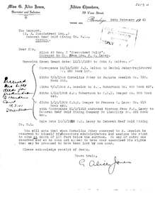
Document - MCCOLL, RANKIN AND STANISTREET COLLECTION: LETTER FROM MISS. G. ALICE JONES RE LAND SALE, 1941
... History House 11 Mackenzie Street Bendigo goldfields ORGANIZATION Mining mccoll rankin and stanistreet McColl Rankin and Stanistreet: Deborah Gold Mines NL. Mr. J. J. Stanistreet Bendigo Deborah Reef Gold Mining Co. NL Miss G. Alice Jones, Barrister and Solicitor Document: Crown Grant ...Document: Crown Grant dated 12/10/1959 to John X. Walton with conveyance 21/3/1912 from F.O. Lacey to Deborah Reef Gold Mining Company no Liability No. 521 Book 460.Miss G. Alice Jones, Barrister and Solicitororganization, mining, mccoll, rankin and stanistreet, mccoll, rankin and stanistreet: deborah gold mines nl., mr. j. j. stanistreet, bendigo, deborah reef gold mining co. nl -
 Bendigo Historical Society Inc.
Document - MCCOLL, RANKIN AND STANISTREET COLLECTION: CENTRAL NAPOLEON GOLD MINING CO. N.L, 28 March 1951
... History House 11 Mackenzie Street Bendigo goldfields ORGANIZATION Business industrial - mining McColl Rankin & Stanistreet mining gold mining Central Napoleon Document: A letter from the Mines Department to Central Napoleon Gold Mining Co. N.L informing them of land application no 94/152 by Mr J. Bakker which a portion of the block is within their lease no 11272 Bendigo, the letter is asking whether or not the Company has any objection to their granting ...Document: A letter from the Mines Department to Central Napoleon Gold Mining Co. N.L informing them of land application no 94/152 by Mr J. Bakker which a portion of the block is within their lease no 11272 Bendigo, the letter is asking whether or not the Company has any objection to their granting of the application.organization, business, industrial - mining, mccoll rankin & stanistreet, mining, gold mining, central napoleon -
 Bendigo Historical Society Inc.
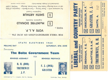
Document - HOW TO VOTE CARDS AND INFORMATION - STATE ELECTIONJUNE 1964
... History House 11 Mackenzie Street Bendigo goldfields ORGANIZATION Government elections 1964 How to Vote cards and information - State Election June 1964. A.: Vote ALP McIntyre, Donald; Smith, Arthur: b.: Bolte Government Team - R. H. (bob) Trethewwy, JP, F. J. (Jock) Granter ...How to Vote cards and information - State Election June 1964. A.: Vote ALP McIntyre, Donald; Smith, Arthur: b.: Bolte Government Team - R. H. (bob) Trethewwy, JP, F. J. (Jock) Granter; c.: Liberal and Country party; Brennan, PG, McIntyre, DRM, Trethewey, RH (LCP), Drechsler, FJ (Lib), Smith, A. On reverse, inscribed: 'Liberals advised 2nd vote to DLP; ALP advised 2nd vote to Lib; DLP advised 2nd vote to Lib'; d.: Pamphlet 'meet your Labor Candidates' - Legislative Council: Smith A and Legislative Assembly DR McL McIntyre; e.: Single sheet flyer - 'To the Electors of Bendigo' with names of candidates (DLP document)organization, government, elections, 1964 -
 Bendigo Historical Society Inc.
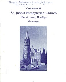
Book - ST JOHN'S PRESBYTERIAN CHURCH, c1972
... House 11 Mackenzie Street Bendigo goldfields CHURCH Centenary st john's bendigo St John's Presbyterian church Forest Street Bendigo Centenary Centenary of St. John's Presbyterian Church Forest Street, Bendigo 1872-1972. List of former Ministers of St. John's Church. A brief account of the history of the church is given. Extracts from minutes of Presbytery Church of Castlemaine 2/7/1872 states that they had not yet held any Sabbath Services in Sandhurst a grant ...Centenary of St. John's Presbyterian Church Forest Street, Bendigo 1872-1972. List of former Ministers of St. John's Church. A brief account of the history of the church is given. Extracts from minutes of Presbytery Church of Castlemaine 2/7/1872 states that they had not yet held any Sabbath Services in Sandhurst a grant not exceeding Twenty Pounds to meet the expenses of such Services necessary to establish a Second Charge in Sandhurst. Services were conducted in the Albion Hall, collections were obtained were liberal, Memorial signed by 104 members and adherents who expressed their desire to be recognized as a Congregation. St. John's first met at the Orderly Room (site of the Art Gallery), then at the Albion Hall (site of the Royal Princess Theatre), they then moved to St. James Hall (now Myer Store). In 1874 a weatherboard church in Forest St. was erected seating 550 persons, and named St. John's Presbyterian Church. It then became known as St John's Free Church and in 1880 it was admitted into the Presbyterian Church of Victoria and named Chalmer's Church. History accounts goes on to explain the further changes which happened within the church to 1972. Many other details have been included in the book such as the costs of the pews the 'Ladies Work Committee', a monthly church paper, Anniversary platform, securing a Manse, the year of the 'black-out', food parcels, the purchase of a building, the pioneering of religious films in church services, renovations, Sunday School, Stewardship Campaign, electronic organ. The history goes on detailing the growth of the organisations in the church; Choir, Sunday School Sunday School Ladies Auxiliary, PWMU, Afernoon Fellowship, Ladies Guild, PGF, Men's Club and Brotherhood, Bible Class, Sporting Clubs, PFA, Mission Band, Creche, Cradle Roll, Board of Management. A list of 'Memorials and Other Gifts Through the Years' from 1904 to 1972. Present 'Office Bearers of the Church'. Photo of present church on front cover, on rear cover is the church erected in 1897. With Indexchurch, centenary, st john's bendigo, st john's presbyterian church forest street bendigo centenary -
 Bendigo Historical Society Inc.
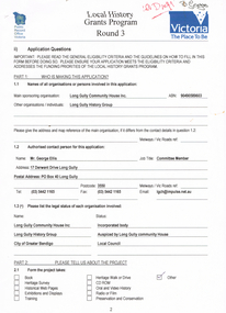
Document - LONG GULLY HISTORY GROUP COLLECTION: LOCAL HISTORY GRANTS PROGRAM ROUND 3
... History House 11 Mackenzie Street Bendigo goldfields BENDIGO History long gully history group The Long Gully History Group - Local History Grants Program Round 3 Public Record Office Victoria Long Gully Community House Inc Long Gully History Group Mr George Ellis City of Greater Bendigo Long Gully Linear Park City of Greater Bendigo Recreation Department City of Greater Bendigo Community Environmental Education Department Long Gully Community Newsletter Eaglehawk Times Bendigo Advertiser Bendigo Tourist Bureau Shared Action Project (St Lukes) Application form to Local History Grants Program Round 3. ...Application form to Local History Grants Program Round 3. Four pages with Public Record Office Victoria and logo in the top left corner and Victoria the Place To Be and logo in the top right corner. Written at the top of the page is ? Draft. Application is for a Poppet Head to acknowledge the Men and their families who worked in the underground mining industry and the achievement that Underground Mining made to make the City of Greater Bendigo what it is today. Also mentioned is estimated cost of of the project.bendigo, history, long gully history group, the long gully history group - local history grants program round 3, public record office victoria, long gully community house inc, long gully history group, mr george ellis, city of greater bendigo, long gully linear park, city of greater bendigo recreation department, city of greater bendigo community environmental education department, long gully community newsletter, eaglehawk times, bendigo advertiser, bendigo tourist bureau, shared action project (st lukes) -
 Bendigo Historical Society Inc.
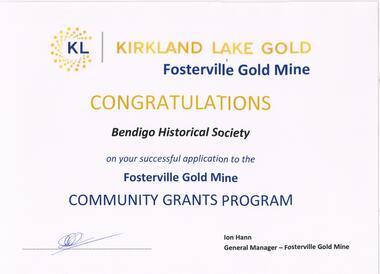
Document - FOSTERVILLE GOLD MINE COLLECTION: CONGRATULATIONS TO BENDIGO HISTORICAL SOCIETY
... History House 11 Mackenzie Street Bendigo goldfields BUSINESS Mining Fosterville Gold Mine Laminated document: 'Kirkland Lake Gold, Fosterville Gold Mine, Congratulations Bendigo Historical Society on your successful application to the Fosterville Gold Mine Community Grants Program. ...Laminated document: 'Kirkland Lake Gold, Fosterville Gold Mine, Congratulations Bendigo Historical Society on your successful application to the Fosterville Gold Mine Community Grants Program. Ion Hann, General manager, - Fosterville Gold Mine' Document un-dated but refers to grant submission received October, 2019.business, mining, fosterville gold mine -
 Bendigo Historical Society Inc.
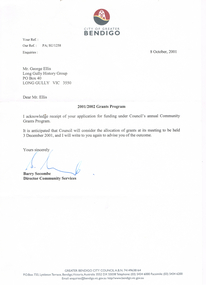
Document - LONG GULLY HISTORY GROUP COLLECTION: LETTER TO MR GEORGE ELLIS
... History House 11 Mackenzie Street Bendigo goldfields BENDIGO History long gully history group The Long Gully History Group - Letter to Mr George Ellis City of Greater Bendigo Long Gully History Group Barry Secombe Letter dated 8 October, 2001 from Barry Secombe, Director Community Services to Mr George Ellis, Long Gully History Group acknowledging his application for funding under Council's Community Grants Program. ...Letter dated 8 October, 2001 from Barry Secombe, Director Community Services to Mr George Ellis, Long Gully History Group acknowledging his application for funding under Council's Community Grants Program. It is anticipated that Council will consider the allocation of grants at its meeting to be held 3 December 2001 and will write again to advise if the application was successful.bendigo, history, long gully history group, the long gully history group - letter to mr george ellis, city of greater bendigo, long gully history group, barry secombe -
 Bendigo Historical Society Inc.
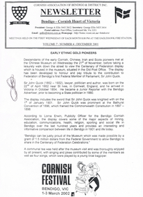
Document - LONG GULLY HISTORY GROUP COLLECTION: CORNISH ASSOCIATION NEWSLETTER DECEMBER 2001
... street to view the Centenary of Federation display which is housed in the Museum, situated in the Old Post Office. Sir John Quick is also mentioned. According to Lorna Erwin, Publicity Officer for the Bendigo Cornish Association, the display covers some of the major aspects of mining, education, communications, health, religion, sporting and social life in Bendigo over the last 100 years and provides an interesting and informative comparison between life in Bendigo in 1901 and life today. Also mentioned is Bendigo can be proud of the Museum which was made possible by a grant...street to view the Centenary of Federation display which is housed in the Museum, situated in the Old Post Office. Sir John Quick is also mentioned. According to Lorna Erwin, Publicity Officer for the Bendigo Cornish Association, the display covers some of the major aspects of mining, education, communications, health, religion, sporting and social life in Bendigo over the last 100 years and provides an interesting and informative comparison between life in Bendigo in 1901 and life today. Also mentioned is Bendigo can be proud of the Museum which was made possible by a grant ...Cornish Association of Bendigo & District Inc. Newsletter Volume 7: Number 4: December 2001. Titled Early Ethnic Gold Pioneers. Members met at the Chinese Museum before taking a walk down the street to view the Centenary of Federation display which is housed in the Museum, situated in the Old Post Office. Sir John Quick is also mentioned. According to Lorna Erwin, Publicity Officer for the Bendigo Cornish Association, the display covers some of the major aspects of mining, education, communications, health, religion, sporting and social life in Bendigo over the last 100 years and provides an interesting and informative comparison between life in Bendigo in 1901 and life today. Also mentioned is Bendigo can be proud of the Museum which was made possible by a grant from the Federal Government to allow Bendigo to share in the Centenary of Federation Celebrations.bendigo, history, long gully history group, the long gully history group - cornish association newsletter december 2001, cornish association of bendigo & district inc, george a ellis, eaglehawk fire statin, chinese museum, centenary of federation, old post office, sir john quick, bendigo advertiser, bathurst convention of 1896, commonwealth constitution 1897 - 1898, lorna erwin -
 Bendigo Historical Society Inc.
Document - STILWELL COLLECTION: EXTRACT FROM THE REGISTRY OF THE TRINIDAD MEDICAL BOARD
... History House 11 Mackenzie Street Bendigo goldfields DOCUMENT Certificate hospital A 3 pages photocopy of the extract from the registry of the Trinidad Medical Board. The following licence to practice medicine and surgery on this island was granted to Charles Stilwell who presented a diploma from the Royal College of Surgeons of England and was found duly qualified. ...A 3 pages photocopy of the extract from the registry of the Trinidad Medical Board. The following licence to practice medicine and surgery on this island was granted to Charles Stilwell who presented a diploma from the Royal College of Surgeons of England and was found duly qualified.document, certificate, hospital -
 Bendigo Historical Society Inc.
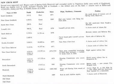
Document - LONG GULLY HISTORY GROUP COLLECTION: NEW CHUM REEF
... History House 11 Mackenzie Street Bendigo goldfields BENDIGO History long gully history group The Long Gully History Group - New Chum Reef Ballerstedt Ashley and Noy Grant South Goldfields New Chum Goldfields South New Chum Lansell's 616 South Bellevue Eureka Eureka Extended New Chum Bellevue New chum Railway Shenandoah North Shenandoah Shamrock Old Chum Little Chum Young Chum Craven Garibaldi Ellesmere South Old Chum New Chum Consolidated North Ellesmere New Chum United Lansell's 222 Lansell's Fortuna Lazarus West End Pioneer Old Chum New Chum Victoria North Old Chum Lansell's Big 180 Sterry Victoria Quartz South Adventure Great Central Victoria Ballerstedt No 3 Adventure Humbold British and American Midway Victoria Consuls Victoria absorbed by Ironbark Hercules and Energetic Victoria Pilot North Hercules and Energetic Great Extended Hercules Pearl Southern Victoria Great Extended Victoria Young Victoria New Catherine Victoria Weatern Victoria New Victoria St Mungo Surprise Mystery Duke of Edinburgh New St Mungo Duchess Tribute South Devonshire Duchess of Edinburgh West United Devonshire Albert United Devonshire Saxon and Celt Hopewell Prince of Wales Phoenix Unicorn South St Mungo Princess Alice Lady Barkly North Devonshire Ranzeau St Mungo Dublin and Cornwall Sadowa Eastwood Ellenborough Belmont and Saxeby Snobs Hill York and Durham La bElle Old Williams United Arcadia Williams United South Catherine Central Catherine Catherine United Murchison New Franklin Catherine Extended Pony Club Oval Housing Commission Mt Alvernia Hospital Fortuna Lunt Army Survey Unit Wybrandt John Brown Factory Canterbury Hercules and Energetic North Red White and Blue Six pages titled New Chum Reef. ...Six pages titled New Chum Reef. No number on the first page, the others are 109 to 113. Mentions location of the reef and some of the rich mines. The mines are mentioned in a table with the Name of Mine; Depth; Production; Dates; Plant, Machinery, Comments and Position. Ballerstedt, Ashley and Noy, and Grant were three of the successful miners. Mines mentioned are: South Goldfields, New Chum Goldfields, South New Chum, Lansell's 616, South Bellevue, Eureka, Eureka Extended, New Chum Bellevue, New chum Railway, Shenandoah, North Shenandoah, Shamrock, Old Chum, Little Chum, Young Chum, Craven, Garibaldi, Ellesmere, South Old Chum, New Chum Consolidated, North Ellesmere, New Chum United, Lansell's 222, Lansell's Fortuna, Lazarus, West End, Pioneer, Old Chum, New Chum Victoria, North Old Chum, Lansell's Big 180, Sterry, Victoria Quartz, South Adventure, Great Central Victoria, Ballerstedt No 3, Adventure, Humbold, British and American, Midway, Victoria Consuls, Victoria absorbed by Ironbark, Hercules and Energetic, Victoria Pilot, North Hercules and Energetic, Great Extended Hercules, Pearl, Southern Victoria, Great Extended Victoria, Young Victoria, New Catherine Victoria, Weatern Victoria, New Victoria St Mungo, Surprise, Mystery, Duke of Edinburgh, New St Mungo, Duchess Tribute, South Devonshire, Duchess of Edinburgh, West United Devonshire, Albert, United Devonshire, Saxon and Celt, Hopewell, Prince of Wales, Phoenix, Unicorn, South St Mungo, Princess Alice, Lady Barkly, North Devonshire, Ranzeau, St Mungo, Dublin and Cornwall, Sadowa, Eastwood, Ellenborough, Belmont and Saxeby, Snobs Hill, York and Durham, La bElle, Old Williams United, Arcadia, Williams United, South Catherine, Central Catherine, Catherine United, Murchison, New Franklin, Catherine Extended, Pony Club Oval, Housing Commission, Mt Alvernia Hospital, Fortuna, Lunt, Army Survey Unit, Wybrandt, John Brown Factory, Canterbury, Hercules and Energetic and the North Red White and Blue.bendigo, history, long gully history group, the long gully history group - new chum reef, ballerstedt, ashley and noy, grant, south goldfields, new chum goldfields, south new chum, lansell's 616, south bellevue, eureka, eureka extended, new chum bellevue, new chum railway, shenandoah, north shenandoah, shamrock, old chum, little chum, young chum, craven, garibaldi, ellesmere, south old chum, new chum consolidated, north ellesmere, new chum united, lansell's 222, lansell's fortuna, lazarus, west end, pioneer, old chum, new chum victoria, north old chum, lansell's big 180, sterry, victoria quartz, south adventure, great central victoria, ballerstedt no 3, adventure, humbold, british and american, midway, victoria consuls, victoria absorbed by ironbark, hercules and energetic, victoria pilot, north hercules and energetic, great extended hercules, pearl, southern victoria, great extended victoria, young victoria, new catherine victoria, weatern victoria, new victoria st mungo, surprise, mystery, duke of edinburgh, new st mungo, duchess tribute, south devonshire, duchess of edinburgh, west united devonshire, albert, united devonshire, saxon and celt, hopewell, prince of wales, phoenix, unicorn, south st mungo, princess alice, lady barkly, north devonshire, ranzeau, st mungo, dublin and cornwall, sadowa, eastwood, ellenborough, belmont and saxeby, snobs hill, york and durham, la belle, old williams united, arcadia, williams united, south catherine, central catherine, catherine united, murchison, new franklin, catherine extended, pony club oval, housing commission, mt alvernia hospital, fortuna, lunt, army survey unit, wybrandt, john brown factory, canterbury, hercules and energetic, north red white and blue -
 Bendigo Historical Society Inc.
Document - MCCOLL, RANKIN AND STANISTREET COLLECTION: NORTH VIRGINIA GOLD MINING CO NL, 1933
... History House 11 Mackenzie Street Bendigo goldfields ORGANIZATION Business gold mine McColl Rankin & Stanistreet North Virginia Gold Mining Co NL Claim No. 115 mining right transfer Quartz Prospecting Claim Transfer New Virginia Syndicate mining right transfer 1933 Lease No. 10027 Claim No 115 Paddys Gully Neanger Mine E/H Bendigo McColl Rankin & Stanistreet, North Virginia Gold Mining Co NL. a/ Agreement dated 13/1/1933 Claim No. 115, mining right transfer from Harold John Veale to J J Hall, J A Michelson, J J Stanistreet & H J Leed owners of lease No. 10027. b/ Consent To Grant Of Lease, Quartz Prospecting Claim or otherwise 13/1/1933. ...McColl Rankin & Stanistreet, North Virginia Gold Mining Co NL. a/ Agreement dated 13/1/1933 Claim No. 115, mining right transfer from Harold John Veale to J J Hall, J A Michelson, J J Stanistreet & H J Leed owners of lease No. 10027. b/ Consent To Grant Of Lease, Quartz Prospecting Claim or otherwise 13/1/1933. Lease No. 10027 Signed by H J Veale in the presence of ?? Leed (p1). Leslie Veale partner of Harold John Veale Claim No. 115 authorizes H J Veale to act on his behalf to transfer the claim to New Virginia Syndicate. Signed by Leslie Veale (p2). Transfer Of Claim etc. to New Virginia Syndicate all right title and interest in Quartz Prospecting Claim numbered 115 known as Paddys Gully line of reef West of Neanger Mine at Sailors Gully Eaglehawk. Signed H J Veale Miner's No. 70059 dated 3/8/1933 (p3). c/ Agreement, North Virginia Mining Company NL application for mining leases from the Crown Numbers 10027 & 10150 Bendigo about 30 acres in Sailors Gully Eaglehawk and Bendigo and a company is intended to be formed and incorporated called North Virginia Gold Mining Company No Liability. Signatures: J J Hall, E D Doyle, J J Stanistreet, E R Grelis, Albert Beischer, J B Young. 3 sheets. d/ Duplicate of 2205.156corganization, business, gold mine, mccoll rankin & stanistreet, north virginia gold mining co nl claim no. 115, mining right transfer quartz prospecting claim transfer new virginia syndicate mining right transfer 1933 lease no. 10027 claim no 115 paddys gully neanger mine e/h bendigo -
 Bendigo Historical Society Inc.
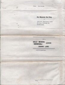
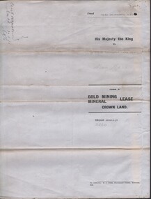
Document - MCCOLL, RANKIN AND STANISTREET COLLECTION: SOUTH DEBORAH GOLD MINES NL: GRANTING OF A TRIBUTE, 20/9/1945
... History House 11 Mackenzie Street Bendigo goldfields ORGANIZATION Mining south deborah gold mines nl Document; McColl, Rankin and Stanistreet; South Deborah Gold Mines; Permission to grant a Tribute on lease 11141, Form K (clause 50); 3 pages Document MCCOLL, RANKIN AND STANISTREET COLLECTION: SOUTH DEBORAH GOLD MINES NL: GRANTING OF A TRIBUTE ...Document; McColl, Rankin and Stanistreet; South Deborah Gold Mines; Permission to grant a Tribute on lease 11141, Form K (clause 50); 3 pagesorganization, mining, south deborah gold mines nl -
 Bendigo Historical Society Inc.
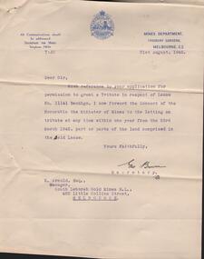
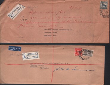
Document - MCCOLL, RANKIN AND STANISTREET COLLECTION: DEBORAH UNITED GOLD MINING CO. NL - CORRESPONDENCE RE AWARD
... House 11 Mackenzie Street Bendigo goldfields ORGANIZATION Business deborah united gold mining co. nl McColl Rankin & Stanistreet: Deborah United Gold Mining Co. NL gold mining correpondence award Document: McColl, Rankin & Stanistreet: Deborah United Gold Mining Co. NL - 2 unopened evelopes addressed to Deborah United Gold Mining Co., Charing Cross, Bendigo, Vic. Sent registered mail from Castlereagh St., New South Wales, No. 9564 and 9305. Written in red on front of (a) in red ink ' aopplication for variation of award ….. ? Increase of 6/- per wek granted ...Document: McColl, Rankin & Stanistreet: Deborah United Gold Mining Co. NL - 2 unopened evelopes addressed to Deborah United Gold Mining Co., Charing Cross, Bendigo, Vic. Sent registered mail from Castlereagh St., New South Wales, No. 9564 and 9305. Written in red on front of (a) in red ink ' aopplication for variation of award ….. ? Increase of 6/- per wek granted April 1948'organization, business, deborah united gold mining co., nl, mccoll, rankin & stanistreet: deborah united gold mining co. nl, gold mining, correpondence, award -
 Bendigo Historical Society Inc.
Document - MCCOLL, RANKIN AND STANISTREET COLLECTION: CENTRAL NAPOLEON GOLD MINING CO. N.L, 3rd November 1943
... History House 11 Mackenzie Street Bendigo goldfields ORGANIZATION Business industry - mining McColl Rankin & Stanistreet mining gold mining grazing application Central Napoleon Daniel Keane Document: Letter sent to Central Napoleon Gold Mining Co from McColl Rankin and Stanistreet regarding Mr Daniel Keane's application for a grazing licence over a block of crown land within the boundaries of the Company's Lease No 10260, this letter is enquiring whether or not the company has any objections to granting Mr Keane's application, the area concerned is marked in grey lead pencil on the map attached to the lease numbered 2205.704a. ...Document: Letter sent to Central Napoleon Gold Mining Co from McColl Rankin and Stanistreet regarding Mr Daniel Keane's application for a grazing licence over a block of crown land within the boundaries of the Company's Lease No 10260, this letter is enquiring whether or not the company has any objections to granting Mr Keane's application, the area concerned is marked in grey lead pencil on the map attached to the lease numbered 2205.704a.organization, business, industry - mining, mccoll rankin & stanistreet, mining, gold mining, grazing application, central napoleon, daniel keane -
 Bendigo Historical Society Inc.
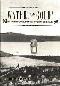
Book - WATER FOR GOLD, 2009
... History House 11 Mackenzie Street Bendigo goldfields VICTORIA History water Bendigo - History Central Victorian Goldfields Coliban Water. Geoffrey Russell Water for Gold, The fight to quench central Victoria's goldfields. Published by Australian Scholarly Publishing with a grant ...Water for Gold, The fight to quench central Victoria's goldfields. Published by Australian Scholarly Publishing with a grant from Coliban Water to celebrate the 15th anniversary of the first serious attempts by the Bendigo Water Works Company in 1859 to supply water to the goldfields of Central Victoria, 288 pages photographs, illustrations & maps. Signed by the author.Geoffrey Russellvictoria, history, water, bendigo - history, central victorian goldfields, coliban water. -
 Bendigo Historical Society Inc.
Document - LA TROBE UNIVERSITY BENDIGO COLLECTION: LEASE OF SANDHURST HOUSE
... A copy of the purchase of a lease contract of the premises known as 'Sandhurst House' (also previously known as Sandhurst Coffee Palace') and its contents, Mitchell Street, Bendigo. It has been granted...History House 11 Mackenzie Street Bendigo goldfields BENDIGO Buildings Sandhurst house La Trobe University Bendigo Collection collection Bendigo Teachers' College ' Sandhurst House ' Bendigo business hostel buildings accommodation Bendigo Teacher's College students female 'Sandhurst Coffee Palace ' 'Coffee Palace ' A copy of the purchase of a lease contract of the premises known as 'Sandhurst House' (also previously known as Sandhurst Coffee Palace') and its contents, Mitchell Street, Bendigo. It has been granted ...A copy of the purchase of a lease contract of the premises known as 'Sandhurst House' (also previously known as Sandhurst Coffee Palace') and its contents, Mitchell Street, Bendigo. It has been granted to The Minister for Public Instruction Melbourne. Dated at Bendigo the 24th day of August, 1944 and signed by N.M. Moore and Lydia S. Heywood. Lease to expire on the 1st July, 1956.The document has a stamped imprint on it with the words R.J. Vicars - Foote Auctioneer Estate Agent Insurance Agent, Commission Agent, Shamrock Blds., Bendigo. Phone 403bendigo, buildings, sandhurst house, la trobe university bendigo collection, collection, bendigo teachers' college, ' sandhurst house, ' bendigo, business, hostel, buildings, accommodation, bendigo teacher's college students, female, 'sandhurst coffee palace, ' 'coffee palace, ' -
 Bendigo Historical Society Inc.
Document - H. A. & S. R. WILKINSON COLLECTION: CONTRACT OF SALE
... History House 11 Mackenzie Street Bendigo goldfields ORGANIZATION Business h.a. & s.r wilkinson real estate Contract of sale of land dated 20th May, 1954 between Mrs. B. S. Grant ...Contract of sale of land dated 20th May, 1954 between Mrs. B. S. Grant (vendor) and Mr. J. C. & Mrs. V. C. Tarr (purchaser). Solicitors for vendor: Noel & Woodward. Solicitor for purchaser: T. M. Williams, Watson & James. Property: that piece of land part of Crown allotment 12 section 19B Parish of Sandhurst City of Bendigo, land described in certificate of title volume 2734 folio 653 and situate No. 30 Shamrock street, Bendigo, together with 5 roomed weatherboard dwelling and all sundry outbuildings, also electric stovette, electric copper, all electric light fittings and shades, rotary clothes line, all blinds and linos. Price: 2,000 pounds.organization, business, h.a. & s.r wilkinson real estate