Showing 1041 items matching " land forms"
-
 Glen Eira Historical Society
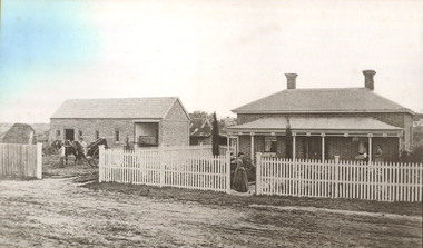
Article - Rosstown Railway
... ... Land Forms...Murray Ross Murray Sugar Beet Mills Mills Elsternwick Land Transport Railways Railway Lines Railway Routes Carnegie Neville Street Carnegie Miller Street Factories Market Gardens Horticulture Peat Soils Land Forms Topography Geology Civic Issues Cone Sugar Industry Elsternwick Plaza Elsternwick Glenhuntly Road Parks and Reserves EE Gunn Reserve Caulfield Racecourse Sportsgrounds Caulfield Carnegie Riddell Parade Clarence Street Aileen Avenue Princes Park Dover Street Marara Road Oakleigh Road Rosanna Street Murrumbeena Crescent North Road Kooyong Road Hawthorn Road Booran Road Koornang Road Poath Road Warragul Road Railway Platforms Railway Buildings Bambra Road Swamps Landforms Landfill Council Landfill Railway Bridges Bridges Railway Underpasses Sporting Clubs Tennis Clubs Bowls Clubs Rosstown Railway Rosanna Street Reserve Maps Railway Maps LIVING IN GLEN EIRA Weickhardt Ian Jowett Des Caulfield South Curraweena Road Oakleigh Caulfield Technical School RETURN TO ROSSTOWN Beet Sugar Industry Crops Land Booms Land Development and Subdivisions Bent Thomas Fink Benjamin Sugar Works Rosstown Hotel Oamdenong Road ROSSTOWN DRY CLEANERS Shops Rosstown Road Rosstown Plate People by Circumstance Migrants Accountants Occupations Professionals THE GRANGE Real Estate Grange Road Financial Agents Judges ROSSTOWN ESTATE Financial Trouble Rabbit Preserving Breweries Political Debates Political Issues Political Electorates Politics Political Science Debt Financial Loans Court Procedures Court Cases Legal Events and Activities MALLESON AND RIGGALL Widowers SEABEACH RAILWAY Economics Economic Deadline Depression 1890s Economic Crash Mortgages Divorce Social Problems Poverty Ross Claude Ross Roderick World War 1914-1918 Wars Military History Servicemen AUSTRALIAN FLYING CORPS Engineers Caulfield Council Swagmen Homelessness Glenhuntly Road Glenhuntly Road Tram Woornack Road Leila Road Wild Cherry Road Melten Avenue Illustrations Steam Trains Trains Horse and Cart Horse-drawn Transport Railway Stations Article Rosstown Railway ...This file contains three items: 1/A review of the ROSSTOWN RAIL TRAIL from LIVING IN GLEN EIRA, vol. 11, 2004, Issue 4, no. 25, date and author unknown. The review explains the purpose of the Rail Trail with a brief narrative of the history behind Rosstown Sugar Mill Railway line. Concluding with information on the location of the Trail and the expected time required to walk the entire track included in the review is a map of the Rail Trail, which marks significant sites along the trail with historic pictures. 2/A newspaper article from THE AGE, dated Tuesday 21/10/1980 and written by Iola Matthews, reporting on the circumstances that led to the publication of the book RETURN TO ROSSTOWN written by Des Jowett and Ian Weickhardt. The article begins with a brief biography of the authors before moving into details of the book’s content, providing a further biography of W. Murray Ross which includes information on his financial ventures – particularly the Rosstown Rail – his marriage and children. The article includes a black and white photograph of Weickhardt and Jowett walking along the route of the railway line, an illustration of the Rosstown sugar works and a map of the area surrounding the site of the mill. 3/Three photocopies of a black and white illustration of the Rosstown sugar works from the east, undated and artist unknown.rosstown rail trail, rosstown, ross william, ross w. murray, ross murray, sugar beet mills, mills, elsternwick, land transport, railways, railway lines, railway routes, carnegie neville street, carnegie miller street, factories, market gardens, horticulture, peat, soils, land forms, topography, geology, civic issues, cone sugar industry, elsternwick plaza, elsternwick, glenhuntly road, parks and reserves, ee gunn reserve, caulfield racecourse, sportsgrounds, caulfield, carnegie, riddell parade, clarence street, aileen avenue, princes park, dover street, marara road, oakleigh road, rosanna street, murrumbeena crescent, north road, kooyong road, hawthorn road, booran road, koornang road, poath road, warragul road, railway platforms, railway buildings, bambra road, swamps, landforms, landfill, council landfill, railway bridges, bridges, railway underpasses, sporting clubs, tennis clubs, bowls clubs, rosstown railway, rosanna street reserve, maps, railway maps, living in glen eira, weickhardt ian, jowett des, caulfield south, curraweena road, oakleigh, caulfield technical school, return to rosstown, beet sugar industry, crops, land booms, land development and subdivisions, bent thomas, fink benjamin, sugar works, rosstown hotel, oamdenong road, rosstown dry cleaners, shops, rosstown road, rosstown plate, people by circumstance, migrants, accountants, occupations, professionals, the grange, real estate, grange road, financial agents, judges, rosstown estate, financial trouble, rabbit preserving, breweries, political debates, political issues, political electorates, politics, political science, debt, financial loans, court procedures, court cases, legal events and activities, malleson and riggall, widowers, seabeach railway, economics, economic deadline, depression 1890s, economic crash, mortgages, divorce, social problems, poverty, ross claude, ross roderick, world war 1914-1918, wars, military history, servicemen, australian flying corps, engineers, caulfield council, swagmen, homelessness, glenhuntly road, glenhuntly road tram, woornack road, leila road, wild cherry road, melten avenue, illustrations, steam trains, trains, horse and cart, horse-drawn transport, railway stations -
 Lakes Entrance Historical Society
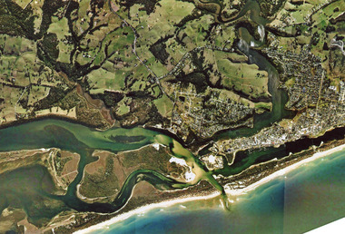
Photograph - Arial View of Lakes Entrance Victoria c2007, 2007c
... Colour aerial photograph of the land forms around the entrance to the Gippsland Lakes, from Kalimna West to Lakes Entrance, North Arm to the ocean. ...Lakes Entrance Historical Society 4 Marine Parade Lakes Entrance gippsland Waterways Navigation Topography Colour aerial photograph of the land forms around the entrance to the Gippsland Lakes, from Kalimna West to Lakes Entrance, North Arm to the ocean. ...Colour aerial photograph of the land forms around the entrance to the Gippsland Lakes, from Kalimna West to Lakes Entrance, North Arm to the ocean. Shows massive sand buildup between Rigby Island and Kalimna, also Bullock Island. Lakes Entrance Victoriawaterways, navigation, topography -
 Bendigo Historical Society Inc.
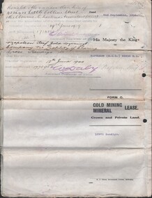
Document - MCCOLL, RANKIN AND STANISTREET COLLECTION: NAPOLEON REEF GOLD MINING CO. N.L, 1938
... 5 Page Legal Document with map of lease area, 6 land application forms (see attached pdf for details)....History House 11 Mackenzie Street Bendigo goldfields ORGANIZATION Business industrial - mining McColl Rankin & Stanistreet mining gold mining Napoleon Reef 5 Page Legal Document with map of lease area, 6 land application forms (see attached pdf for details). ...5 Page Legal Document with map of lease area, 6 land application forms (see attached pdf for details).organization, business, industrial - mining, mccoll rankin & stanistreet, mining, gold mining, napoleon reef -
 Bendigo Historical Society Inc.
Book - STRAUCH COLLECTION: WESTGARTHTOWN
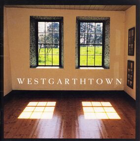
... A history of Westgarthtown, German and Wendish immigrants first settled at Westgarthtown in March 1850, situated 16 Kilometres north of Melbourne this land now forms part of the suburbs of Thomastown and Lalor. ...History House 11 Mackenzie Street Bendigo goldfields VICTORIA History german Victoria-history-German-Westgarthtown A history of Westgarthtown, German and Wendish immigrants first settled at Westgarthtown in March 1850, situated 16 Kilometres north of Melbourne this land now forms part of the suburbs of Thomastown and Lalor. ...A history of Westgarthtown, German and Wendish immigrants first settled at Westgarthtown in March 1850, situated 16 Kilometres north of Melbourne this land now forms part of the suburbs of Thomastown and Lalor. Soft cover 36 pages with black & white and coloured photographs,maps & illustrations. Published by the Heritage Council Victoria and the City of Whittlesea.victoria, history, german, victoria-history-german-westgarthtown -
 Federation University Historical Collection
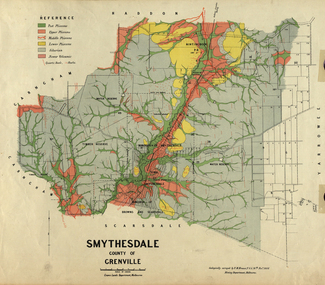
Map, Smythesdale, County of Grenville, 1888, 1889
... Krause, was a professor at the Ballarat School of Mines. This land was printed form the Crown Lands Department, Melbourne. ...Krause, was a professor at the Ballarat School of Mines. This land was printed form the Crown Lands Department, Melbourne. smythesdale krause f.m. krause ferdinand krause nitingbool watson's hill surface hill sugarloaf hill haddon Coloured map of the County of Grenville. ...The map maker, Ferdinand M. Krause, was a professor at the Ballarat School of Mines. This land was printed form the Crown Lands Department, Melbourne. Coloured map of the County of Grenville. The edge has been taped. The scale is 40 chains to 1 inch. The map is accompanied with a foolscap sheet printed by the Mines Department in 1898. It is a Report on the Parish of Smythesdale by F.M. Krause and includes information on the water reserve, worked quartz veins, Watson's Hill, Surface Hill and Sugarloaf Hill, Haddon, Trunk Lead and the Crucible Shaft. smythesdale, krause, f.m. krause, ferdinand krause, nitingbool, watson's hill, surface hill, sugarloaf hill, haddon -
 Kew Historical Society Inc
Plan, J R Mathers & McMillan, Sackville, Thomas & Lytton Streets, Kew, Twentieth Century
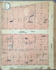
... The land would have originally formed part of the Dumaresq Estate. ...The land would have originally formed part of the Dumaresq Estate. ...The Kew Historical Society's map collection includes a substantial number of real estate subdivision plans, mainly of Kew but also of surrounding suburbs in Melbourne. Most of the subdivision plans date from the 1920s and 1930s when the districts old homes and local farmland were being split up to accommodate residential growth in the postwar period. These early plans were assembled by a local firm, Jas R Mather & McMillan, which had an office in Cotham Road. Many of the plans, and sometimes photos, were annotated by the agents.Subdivision plans are historically important documents used as evidence for the growth of suburbs in Australia. They frequently provide information about when the land was sold as well as evidence relating to surveyors and real estate and financial agents. The numerous subdivision plans in the Kew Historical Society's collection represent working documents, ranging from the initial sketches made in planning a subdivision to printed plans on which auctioneers or agents listed the prices for which individual lots were sold. In a number of cases, the reverse of a subdivision plan in the collection includes a photograph of a house that was also for sale by the agent. These photographs provide significant heritage information relating house design and decoration, fencing and household gardens.The photograph may also be aesthetically significant depending on the importance of the photographic atelier.Lithographed subdivision plan for an un-named estate with 28 allotments facing Lytton, Sackville and Thomas Streets in Kew. The land would have originally formed part of the Dumaresq Estate. subdivision plans - kew, lytton street, sackville street, thomas street - kew -
 Bendigo Historical Society Inc.
Document - KELLY AND ALLSOP COLLECTION: VICTORIA LAND TAX ACT 1910 - FORM, 31/12/1910 to 01/03/1911
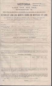
... KELLY AND ALLSOP COLLECTION: VICTORIA LAND TAX ACT 1910 - FORM...'Return of Land and Monies Owing on Mortgage of Land.' Each form partly filled out by Arthur Allsop in pencil, ie 'Particulars of Land' section. ...'Return of Land and Monies Owing on Mortgage of Land.' Each form partly filled out by Arthur Allsop in pencil, ie 'Particulars of Land' section. ...Document. KELLY & ALLSOP COLLECTION. Three copies of Schedule B of Land Tax Act of Victoria 1910. 'Return of Land and Monies Owing on Mortgage of Land.' Each form partly filled out by Arthur Allsop in pencil, ie 'Particulars of Land' section. He owns two houses in Wills St and a vacant block of land at Pyke/Brodie Streets. Instructions to taxpayers 'Every owner of land must furnish a return before 1st March 1911 of all lands owned on 31 Dec 1910.'Taxation Office of Victoriabusiness, stockbroker, kelly & allsop, kelly & allsop collection, victoria land tax act 1910, schedule b -
 Mt Dandenong & District Historical Society Inc.
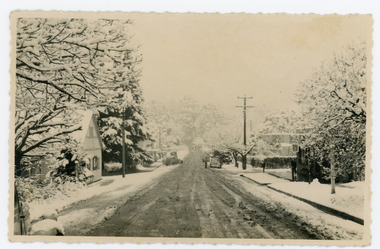
Photograph, Main Street Sassafras in Snow, c1952
... At this time she donated part of her remaining land to form a Village Green. Eva Shugg lived to the age of 106 and died in 2007....At this time she donated part of her remaining land to form a Village Green. Eva Shugg lived to the age of 106 and died in 2007. ...The Main Street of Sassafras c1952 showing Mechanics Institute at left under snow. Note the hedge around the area that is now the Village Green. At the time of the photo the land belonged to Eva Shugg where she ran holiday flats called St Annes. Eva Shugg sold her house to Max Dower to extend his nursery in the 1970s and built a new home around the corner on Mountain Highway. At this time she donated part of her remaining land to form a Village Green. Eva Shugg lived to the age of 106 and died in 2007.Black and white photograph with serrated edge showing the Main Street of Sassafras under snow c1952. Mechanics' Institute is on LHS with cars parked outside the site of Sassafras House.On reverse written in pencil 'Main Street, Sassafras"sassafras, snow, mechanics' institute, mechanics' hall, village green, eva shugg, max dower -
 Cockatoo History & Heritage Group
photograph, Desmond, home of O'Hara family
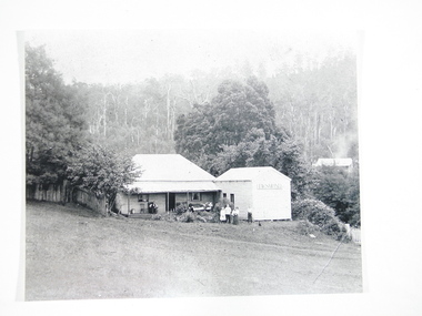
... "Desmond", on the Cockatoo Creek, on land which now forms part of Alma Treloar Reserve, was the home of the O'Hara family ca. 1910. ...Cockatoo History & Heritage Group Cockatoo yarra-valley-and-the-dandenong-ranges "Desmond", on the Cockatoo Creek, on land which now forms part of Alma Treloar Reserve, was the home of the O'Hara family ca. 1910. ..."Desmond", on the Cockatoo Creek, on land which now forms part of Alma Treloar Reserve, was the home of the O'Hara family ca. 1910. The poet John Bernard O'Hara, used to visit his mother there, and remembered many wonderful holidays with the "city folk" who travelled to Cockatoo on "Puffing Billy" and camped along the creek. The family in the foreground is most likely the O'Hara family.The photograph is significant because it shows a Cockatoo home of around 1910.Black and white photograph of "Desmond", home of the O'Hara family, with a family group in foreground. Situated on Cockatoo Creek, on land now known as Alma Treloar Reserve. Circa 1910.cockatoo homes, "desmond", o'hara family, cockatoo creek, john bernard o'hara. -
 City of Moorabbin Historical Society (Operating the Box Cottage Museum)
Photograph - 115 Jasper Road, Bentleigh, Allan / Grewer Estate, c. 1890's
... The block with the house pictured remained in the family until 1969. The land now forms part of Our Lady of Sacred Heart College. ...The block with the house pictured remained in the family until 1969. The land now forms part of Our Lady of Sacred Heart College. ...115 Jasper Road, Bentleigh East was a market garden owned by James Allan. In 1880 the property was transferred to David Grewar (Gruar) who had married James' niece Mary Allan. In 1926 part of the land was subdivided and sold as residential blocks. The block with the house pictured remained in the family until 1969. The land now forms part of Our Lady of Sacred Heart College. The description of the land owned by David Kidd Grewer (also spelt Gruar) in 1885: Fourteen acres or thereabouts at the corner of Jasper Road and Patterson’s Road East Brighton being part of Crown Block of 5720 acres Parish of Moorabbin County of Bourke being land comprised in Certificate of Title Volume 1344 Folio 268692 on which is erected a 4 roomed brick house with 2 rooms of wood at the rear and stable and a 2 roomed weatherboard cottage valued as under: 14 acres of land less crops £629.0.0 4 roomed brick house £250.0.0 Other buildings £50.0.0 2 roomed weatherboard cottage £35.0.0 Early pioneer family of the City of Moorabbin.Black and White photo in picture framegrewar, market garden, moorabbin, bentleigh, jasper road, housing, pioneer, james allan, orchard -
 Mt Dandenong & District Historical Society Inc.
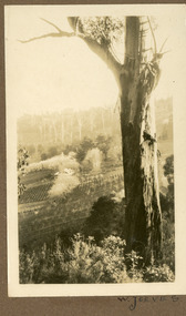
Photograph
... He established a commercial garden, initially growing vegetables but later flowers and shrubs. This land now forms part of Kalorama Park. The building in the photograph is the Kalorama Homestead with shrubs and trees planted in rows on the sloping site. ...He established a commercial garden, initially growing vegetables but later flowers and shrubs. This land now forms part of Kalorama Park. The building in the photograph is the Kalorama Homestead with shrubs and trees planted in rows on the sloping site. ...The photograph is from the album of Ivy May Child. It shows a view across the holding of Walter Jeeves. Walter was the second son of Ellis Jeeves and grandson of Isaac Jeeves, the pioneer. Walter was given the house 'Kalorama' and 20 acres of lnd - most of it sloping. He established a commercial garden, initially growing vegetables but later flowers and shrubs. This land now forms part of Kalorama Park. The building in the photograph is the Kalorama Homestead with shrubs and trees planted in rows on the sloping site. Ivy May Child (1910 – 1989) was the daughter of Arthur Edward (Ted) Child (1878 – 1964) and Ethel May Madden (1888 – 1970). Ted Child was the son of Matthew Francis Child (1839 – 1933) and Martha Jeeves (1857 – 1926). He was the grandson of one of the early pioneers Francis Child. Ivy grew up on the family property on Childs Road and took many photographs. Most of these are glued into her photo album. The album covered the years from c1927 – 1932. Ivy married Henry William Burgess (1906 – 1968) in 1944. The photographs remain in their original state in the album with individual copies made. Black and white photograph with a large gum tree in the foreground, a sloping area of cleared, cultivated land and homestead in the centre and a forested area in the distance.An inscription below the photograph in the album reads: W. JEEVESwalter jeeves, jeeves, kalorama homestead, kalorama park -
 Ballarat Tramway Museum
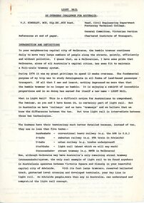
Document - Document - Discussion Paper, Light Rail; An overseas Challenge for Australia
... During 1076 he was overseas to study the developments in all forms of land-based passenger transport. He found the tramcar was enjoying a rebirth and a new name - LIGHT RAIL. ...During 1076 he was overseas to study the developments in all forms of land-based passenger transport. He found the tramcar was enjoying a rebirth and a new name - LIGHT RAIL. ...Ron Bridger was an avid collector of items related to transport, predominately Trams. These items include newspaper cuttings, pamphlets, reports, timetables, fares prices plus special items relating to events. Items from Melbourne and regional Victoria, interstate - Adelaide and Sydney, plus overseas, make up this collection. A discussion paper written by W J Kingsley, Head of Civil Engineering Department at Footscray Technical College. During 1076 he was overseas to study the developments in all forms of land-based passenger transport. He found the tramcar was enjoying a rebirth and a new name - LIGHT RAIL. This paper goes into depth the various forms of transport and compares the efficiency of each. It provides a challenge for Australia to consider the benefits of Light Rail.Six sheets of A4 paper, printed on both sides - 12 page document. Paper titled "Light Rail - An overseas challenge for Australia" Topic divided into sections: Introduction and Definition; The Private Motor Car; Gee-Whizz; Energy; Vehicles; Track; Overhead and Signalling; Standardization; Some Particular Applications of Real Note; CostAuthor W J Kingsley, w jkingsley, civil engineering department, overseas study, light rail, travel comparisons, efficiency of travel options, ron bridger collection, 1976, as box 48a -
 Wangaratta RSL Sub Branch
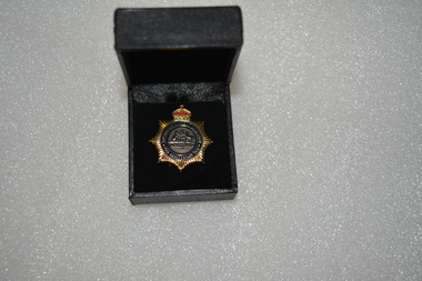
Badge - Boxed badge, 2012
... The Australian Women’s Land Army (AWLA) was formed during the Second World War to combat rising labour shortages in the farming sector. ...The Australian Women’s Land Army (AWLA) was formed during the Second World War to combat rising labour shortages in the farming sector. ...Badge received by Dorothy Kiely in 2012 on the 70th anniversary of the Australian Women's Land Army. The Australian Women’s Land Army (AWLA) was formed during the Second World War to combat rising labour shortages in the farming sector. From December 1941, when Japan entered the war, the nation’s need to build up its armed forces was placed above the needs of other industries. Agricultural labour was steadily diverted to the armed services and war industry To meet the shortfall in rural labour, State and private women’s land organisations were organised, modelled on those established in Great Britain during the First and Second World Wars. A national body was formed on 27 July 1942 under the jurisdiction of the Director General of Manpower. While policy was devised by the Commonwealth Government, the organisation of the AWLA remained State-based. An extensive recruiting campaign was undertaken for new members. Most members of the existing land armies were later incorporated into the AWLA as well. Black box containing gold star shaped badge with red crown above Australian coat of arms Badge:-Australian Women's Land Army 70th Anniversary 2012 Box:- top in gold lettering 70th Anniversary of the Australian Women's Land Armyawla, ww2, dorothy kiely -
 Ararat Gallery TAMA
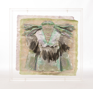
Mixed media, Inga Hunter, Nrat-tuan Boat Leader's Robe, 1986-1989
... Many thousands live entirely on boats and never set foot on any form of land, even avoiding the floating islands. ...Many thousands live entirely on boats and never set foot on any form of land, even avoiding the floating islands. ...“Apart from the vast and sophisticated space fleet, the only forms of transport used by the Nrati-Tuan are boats and rafts. All the inhabitants are more at home in the water than on the land, but some transport is necessary, both for people and freight. Every family has at least two boats and an assortment of rafts. Many thousands live entirely on boats and never set foot on any form of land, even avoiding the floating islands. The Boatleader is really a leading transport official; the top office in a long chain of others, from the smallest boat-boy, to the night boatwatches who keep the waterways safe for traffic. There are several ranks of Boatleader, whose major function is to settle disputes about water rights and water paths. Courts of dispute sit regularly, handling the hundreds of problems which arise about water use, headed by a Boatleader of one rank or another. This robe is worn by the most senior of all. He is the representative of water rights at the great Court of the Imperium. To the Nrat-Tuan it is more a sacrifice than an honour to attend the Court, because none find it easy to stay on still, dry land for extended periods of time. Nrati-Tuan delegates to the Irusaqui Court are rewarded with high honours on their planet, to show public respect and gratitude for their endurance.” -Inga Hunter -
 Eltham District Historical Society Inc
Audio - Audio Recording, Audio Recording; 2018-10-13 Eltham Community Town Hall Meeting, 13 Oct 2018
... . * following meaningful engagement with residents of the Shire, to place sufficient planning controls on the site of the former Eltham Shire Office to ensure that any future development of that land responds to Eltham's form and character and properly protects public amenity, access and use. * to make all proposals for the development of 895 and 903-907 Main Rd, Eltham available for public inspection as soon as they are received by Council. .... * following meaningful engagement with residents of the Shire, to place sufficient planning controls on the site of the former Eltham Shire Office to ensure that any future development of that land responds to Eltham's form and character and properly protects public amenity, access and use. * to make all proposals for the development of 895 and 903-907 Main Rd, Eltham available for public inspection as soon as they are received by Council. ...Meeting to discuss the Nillumbik Shire Council's proposed sale and devlopment of the former Shire Office site at 895 Main Road as well as the Eltham War Memorial including the Maternal and Infant Welfare Centre, Eltham Pre-school and Eltham War Memorial Hall and Memorial Gardens at 903-907 Main Road which also includes thje Eltham Senior Citizen's Centre. The meeting was attended by more than 300 people which considered the following: Motion from public meeting – Saturday 13th October, 2018 1. This meeting has no confidence in Nillumbik Shire Council's proposed process for the re-development of 895 and 903-907 Main Rd, Eltham and we deplore the cursory attention given to public consultation to date. 2. We call on Council: *to preserve the Eltham War Memorial building complex at 903-907 Main Rd, Eltham, and retain their existing uses in accordance with the Eltham War Memorial Trust purpose; and retain the Cenotaph and Eltham Senior Citizens' Centre. * to retain council ownership of all land at 895 and 903-907 Main Rd, Eltham for our community and future generations. * following meaningful engagement with residents of the Shire, to place sufficient planning controls on the site of the former Eltham Shire Office to ensure that any future development of that land responds to Eltham's form and character and properly protects public amenity, access and use. * to make all proposals for the development of 895 and 903-907 Main Rd, Eltham available for public inspection as soon as they are received by Council. Moved: Greg Johnson Seconder: Andrew Lemon * carried unanimously1:28:52 duration Digital MP3 File 30.5 MB 895 main road, 903-907 main road, community meeting, eltham pre-school, eltham shire office, eltham war memorial, eltham war memorial hall, infant welfare centre, nillumbik shire council, senior citizen's centre -
 Ballarat and District Irish Association
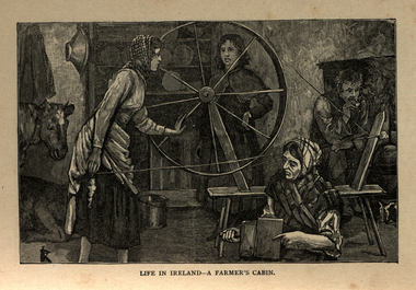
Image, Life in Ireland - A Farmer's Cabin, c1864
... Those who lived close to the sea would collect seaweed and use it spread on their land as a form of manure. The dependency of so much of the population on the Potato as their sole source of food was to prove disastrous during the Famine years. ...Those who lived close to the sea would collect seaweed and use it spread on their land as a form of manure. The dependency of so much of the population on the Potato as their sole source of food was to prove disastrous during the Famine years. ...The tenant lived at the mercy of the resident landlord. Home was a one-roomed house, a chimney of wicker work plastered over with mud or just a hole in the roof. The walls might consist of mud too, or sods of grass. Any windows, were rarely glazed and would be open to the elements all year round. The Pig, if any, was kept in the house, the most valuable possession. Sold for cash at local market. The main items in the house were a potato pot and water bucket. As well as mother, father and children, there could well be grandparents all living in the same cramped conditions. The family would sleep on rushes or straw lain on the floor. Most tenants were tenants 'at will ', which meant they could be evicted at the 'will' of the landlord. Some had a lease for the life of the father and the eldest son, and this meant they were relatively safe from eviction as long as they could pay their rent. There was a tradition of passing on a portion of your land from father to each of the sons, who would build a small dwelling, and in turn pass a portion onto their own sons. This cycle of subdivision meant that many families were surviving on a tiny plot of land from which to derive a crop of potatoes for the year. Women worked hard in this environment, rearing children, cooking, cleaning, tending to any animals such a pigs or chicken and when needed, helping in the potato field. Life was dictated by the annual rent due to the landlord. Other typical expenses could be the Hearth Tax (actually charged by the number of fire places in a house) Turf, Hay (for any farm animals) and tithes. A tax known as the tithes were calculated at one tenth the value of everything saleable. Tithes were a bitter issue. They were for the support of the Church of Ireland, Protestant Bishops and Ministers, and a cess tax for the construction and maintenance of Protestant Church buildings. The problem being that the vast majority of those paying the Tax were Catholic and paying to support something that was contrary to their beliefs. Potatoes were the staple diet from September through to the end of Spring of the following year. But the summer months were months of hunger and hardship as they waited for the following harvest to come in Autumn. During these months people had to resort to eating anything they could find; turnips, cabbage, even wild grass, nettles, wild berries and dandelions. Those who lived close to the sea would collect seaweed and use it spread on their land as a form of manure. The dependency of so much of the population on the Potato as their sole source of food was to prove disastrous during the Famine years. [http://www.youririshroots.com/irishhistory/tenant.php, accessed 14 December 2013]A woman spins wools, while another cards fleece in preparation for spinning. I man smokes a pipe by an open fireplace, while a cow takes shelter in the cabin for warmth. ballarat irish, cabin, spinning, wool, cow -
 Surrey Hills Historical Society Collection
Photograph, Muriel Pornitz (deceased), Quarry on site of Grovedale Road - James Street Park
... The photo is of a painting of the dam formed on land between Grovedale Road and James Street, Surrey Hills. ...Surrey Hills Historical Society Collection 190A Canterbury Road Canterbury melbourne The photo is of a painting of the dam formed on land between Grovedale Road and James Street, Surrey Hills. ...The photo is of a painting of the dam formed on land between Grovedale Road and James Street, Surrey Hills. It was painted in 1927 by Miss Muriel Pornitz, an art teacher, who lived in Grovedale Road. The land had been part of Mr James Maling Snr’s property and in the 1880s clay was removed to build houses, including his own located on the corner of Weybridge and James Streets. Maling grazed cattle on this area and used it as a dam. The land was subsequently made into parkland, the quarry / dam having been filled in after several drownings had occurred in the 1920s/1930s. See also SHP94, another copy of the same. Muriel Hedwig Lucy Pornitz lived at 22 Grovedale Road, Surrey Hills. She was born c1894 in Balwyn; died in Kew on 1 December 1982. She was the daughter of Konrad Pornitz (1864-1903) and his wife Charlotte Richardson Gooderidge (1863-1942), known as Tottie, who married in 1890. Konrad Pornitz is listed in the 1892 directory as living in Edgevale Road, Kew and the business Pornitz and Ross at 291 & 293 Little Collins Street, importers and commission merchants. The 1896 directory gives the Kew address as 176 Edgevale Road, Kew, however the business Pornitz and Ross was dissolved on 1st day of October 1892, by mutual agreement. Legal notice advised that: Mr Pornitz will hereafter carry on the business on his own behalf at the same address, under the style "Pornitz and Ross". Muriel is buried in Box Hill Cemetery (B-086-0042) along with Ulrich Horst Holm Pornitz known as Horst or Bon (d 1957) and Edith Olga Pornitz (d 1951), her brother and sister. A further sibling (Konrad b 1891) died in infancy. He is buried with his mother in Boroondara (Kew) Cemetery - C/E A 0366. Konrad died at his home 'Yarran' in Lane Cove Road, North Sydney on 31 October 1903; reported in the Sydney Morning Herald. Buried Gore Hill Cemetery, St Leonards, North Sydney. The headstone reveals he was born in Chemnitz, Saxony in 1863. Muriel was also known as Muriel Pornett. She studied at the South Australian School of Arts & Crafts in 1911 under James Ashton and Fred Britton, and at the Australian School of Etching in Sydney. She was also an illustrator and cartoonist. The photo, and the painting from which it is derived, documents the landscape prior to close settlement and is material to early building and farming in the Surrey Hills area.A black and white photograph of a painting of a landscape of parkland. Two trees are on top of a rise and are reflected at the bottom in water. The signature of the artist is in the bottom right corner: "AUST MP 192" (and the rest is cut off).(miss) muriel pornitz, grovedale road, james street, surrey hills, artists, parks and reserves, (mr) john butler maling, snr, quarry, dam, (miss) muriel hedwig lucy pornitz, box hill cemetery, muriel pornett -
 Warrnambool and District Historical Society Inc.
Document, Lease of Land by Victorian Railways to Warrnambool Woollen Mill Co Ltd, 1952
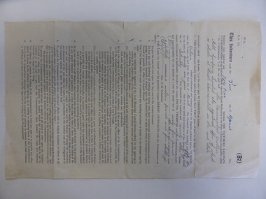
... Printed form with diagram of the land in question coloured in pink . ...land would have been used for parking during the period of 1950's to 1970's which was a successful period of manufacturing and trade for the Woollen Mill. A link between an important infrastructure and one of Warrnambool's most important industries. warrnambool warrnambool woollen mill warrnambool railways lease victorian railways and warrnambool woollen mill Dated 30th April 1952. Signed R Naylor for the Warrnambool Woollen Mill and two unreadable signatures for Victorian Railways. Four page folded document cream in colour . Printed form ...The Warrnambool Woollen Mill was established in 1910 in South Warrnambool by a local company, with the building erected on a site that formerly housed another woollen mill destroyed by fire in 1882. The Warrnambool Woollen Company operated successfully for many years with over 700 employees in the 1940s and a good national reputation for quality goods. It made blankets and other woollen goods and was the first company in Australia to manufacture electric blankets. In the 1960s the mill was sold to the Dunlop Company and for the next thirty years it was bought and sold several times, finally closing in 2000 after 90 years of operation. The woollen Mill was built on a site which was in easy access to the railway line which operated along the original tramway line from the town to the jetty. It is possible that this land would have been used for parking during the period of 1950's to 1970's which was a successful period of manufacturing and trade for the Woollen Mill. A link between an important infrastructure and one of Warrnambool's most important industries.Four page folded document cream in colour . Printed form with diagram of the land in question coloured in pink . Seals of both Victorian railways and Warrnambool Woollen mill are stamped beside signatories on page 3. Dated 30th April 1952. Signed R Naylor for the Warrnambool Woollen Mill and two unreadable signatures for Victorian Railways.warrnambool, warrnambool woollen mill, warrnambool railways, lease victorian railways and warrnambool woollen mill -
 Warrnambool and District Historical Society Inc.
Book - Children's Magazine, Rev. W. Meynell Whittemore, Sunshine for 1886, 1886
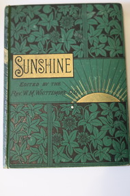
... land in the Tooram, Allansford area. This book is of interest as an example of a prize given at a Warrnambool Sunday School in the late 19th century and as a memento of a pioneering farming family in the Logans Beach area. The book also has antiquarian value. Matilda Logan St. John's Presbyterian Church Warrnambool Logan's Beach A Children's Annual formed ...A Children's Annual formed by re-publishing one year's issues of a monthly magazineThis is a book of 190 pages. It has a green cover with embossed floral patterns and a rising sun sketch outlined in gold. The black printing on the cover and spine has a gold patterned background. The pages contain advertisements, printed material and black and white sketches. fictionA Children's Annual formed by re-publishing one year's issues of a monthly magazine matilda logan, st. john's presbyterian church warrnambool, logan's beach -
 Warrnambool and District Historical Society Inc.
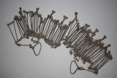
Chain link measure, Gunter's Chain, 19th Century
... Gunter’s Chain Land Measurement Tools history of warrnambool This is a metal tool which consists of 100 metal pieces or links joined together by loops at each end with two metal loops in between each link. The links joined together form ...A Gunter’s Chain, an old land surveying instrument, is named after its inventor, Edmund Gunter (1581-1626), an English mathematician and astronomer. It was first produced in 1620. The tool has 100 links and is 66 feet or one chain long. The links are marked off in groups of ten by metal tags or rings. A quarter chain (25 links) is called a rod or pole and ten chains make a furlong and 80 chains a mile. The traditional cricket pitch is 22 yards or one chain long. This chain is said to have been used by Gilbert Nicol when the Warrnambool to Hamilton Road was constructed in the 19th century. Gilbert Nicol was an early settler in Warrnambool who, with John Craig, established the first hotel (and the first building) in Warrnambool in 1847. Nicol later owned the property ‘Rosehill’ in the Warrnambool area. As the chain was given to the Warrnambool and District Historical Society by the Town Clerk, Keith Arnel, it is likely that the chain was one of the items in the old Warrnambool MuseumThis Gunter’s Chain is of importance because it is an early land measuring device that was used for over 250 years and has great historical and mathematical significance. If it is correct that it was used by Gilbert Nicol when the Warrnambool to Hamilton Road was built then it has considerable local significance and dates back to the 19th century. This is a metal tool which consists of 100 metal pieces or links joined together by loops at each end with two metal loops in between each link. The links joined together form a chain. The two ends of the chain have small metal handles attached. At intervals along the chain there are additional rings or metal pieces attached. The metal is very rusted.gunter’s chain, land measurement tools, history of warrnambool -
 Warrnambool and District Historical Society Inc.
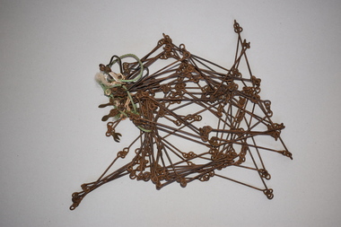
Chain link measure, Gunter, Early 20th century
... It is an early land measuring tool that was used for over 250 years and has great historical and mathematical significance. A Gunter’s Chain would have been used when forming and building local roads from the earliest days of settlement. 2. ...This Gunter’s Chain, an old land surveying instrument, is named after its inventor, Edmund Gunter (1581-1626), an English mathematician and astronomer. It was first produced in 1620. The tool has 100 links and is 66 feet or one chain long. The links are marked off in groups of ten by metal rings or tags. A quarter chain (25 links) is called a rod or pole and ten chains make a furlong and 80 chains make a mile. The traditional cricket pitch is 22 yards or one chain long. This Gunter’s Chain is of considerable significance because: 1. It is an early land measuring tool that was used for over 250 years and has great historical and mathematical significance. A Gunter’s Chain would have been used when forming and building local roads from the earliest days of settlement. 2. It has a possible local connection as it was given to the Historical Society by a local person in 1965 and possibly came from the property of ‘Rosehill’ This is a metal tool which consists of 100 metal pieces or links joined together by loops at each end with two metal loops in between each link. The links joined together form a chain. The two ends of the chain have small metal handles attached At intervals along the chain there are additional rings or metal pieces attached. Some white and green rope material has been used to bundle up the chain. The metal is somewhat rusted. gunter’s chain, land measurement tools, history of warrnambool -
 Warrnambool and District Historical Society Inc.
Clothes brush & holder, Mid 20th century
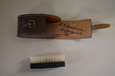
... land. George Tomlinson’s father, also William, continued to farm in the area and was known as a fine judge of cattle and sheep. This case and brush are of interest as an example of the brushes men used in the mid 20th century. The items are also of interest as they belonged to a member of a well-known Ballangeich family (Tomlinsons) Men’s Toiletries Ballangeich history of warrnambool ‘G.E. Tomlinson Ballangeich Victoria’ .1 This is a piece of brown leather rolled over and stitched with yellow thread to form ...The brush in this case could have been used as a hair brush or a clothes brush. It is enclosed in a leather case and was probably an item made for travellers. The brush and case belonged to George Tomlinson of Ballangeich. Ballangeich is a small settlement on the Hopkins Highway about 27 kilometres from Warrambool. George Tomlinson’s grandfather, William Tomlinson , established a farming property at Ballangeich in 1865 and opened a hotel, ‘Half Way House’ on part of the land. George Tomlinson’s father, also William, continued to farm in the area and was known as a fine judge of cattle and sheep. This case and brush are of interest as an example of the brushes men used in the mid 20th century. The items are also of interest as they belonged to a member of a well-known Ballangeich family (Tomlinsons).1 This is a piece of brown leather rolled over and stitched with yellow thread to form a container or case. The case has a closing mechanism – a leather strap and metal buckle. .2 Inside the leather case is a brush with a brown Bakelite back with horsehair inserted. ‘G.E. Tomlinson Ballangeich Victoria’men’s toiletries, ballangeich, history of warrnambool -
 Warrnambool and District Historical Society Inc.
Polaroid Camera, 1980s
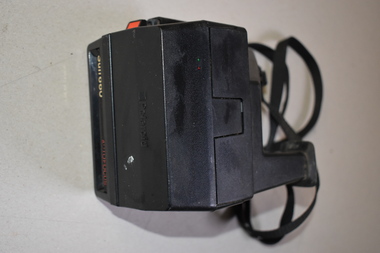
... Land. He developed the concept of instant photography following his production of polarized sunglasses. This Sun 660 model was first produced in 1981. Polaroid cameras were very popular in the 1970s and 80s. The Polaroid Company was re-formed...Land. He developed the concept of instant photography following his production of polarized sunglasses. This Sun 660 model was first produced in 1981. Polaroid cameras were very popular in the 1970s and 80s. The Polaroid Company was re-formed ...The polaroid camera was first produced in Massachusetts, U.S.A. in 1937 by Edwin Land. He developed the concept of instant photography following his production of polarized sunglasses. This Sun 660 model was first produced in 1981. Polaroid cameras were very popular in the 1970s and 80s. The Polaroid Company was re-formed several times and sold to The Impossible Project Company in 2017. Instant cameras can still be purchased today. This camera has no known local provenance but is retained for display purposes.This is a Polaroid brand instant camera enclosed in a black case. It has a cloth strap with plastic attachments. It features sonar autofocus technology.Polaroid Sun 660 Autofocus -
 Warrnambool and District Historical Society Inc.
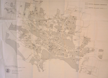
Map - City of Warrnambool Freehold and Managed Crown Land, City of Warrnambool Council, 14th April 1994
... Warrnambool and District Historical Society Inc. 2 Gilles Street (south of Merri St) Warrnambool great-ocean-road This map was drawn up by the City of Warrnambool Council staff to provide information on the land in Warrnambool that was owned or managed by the Council. This map is of considerable importance as it gives information in map form of the Warrnambool land that is owned (freehold) by the City of Warrnambool and the land that is managed Crown land. ...This map was drawn up by the City of Warrnambool Council staff to provide information on the land in Warrnambool that was owned or managed by the Council.This map is of considerable importance as it gives information in map form of the Warrnambool land that is owned (freehold) by the City of Warrnambool and the land that is managed Crown land. This is of interest to researchers and those seeking information on specific areas of land in Warrnambool.This map has digital mapping. The map has a white background with black and white mapping details of Warrnambool. It has the City of Warrnambool seal. Scale of map: 1:7500warrnambool city council, warrnambool -
 Warrnambool and District Historical Society Inc.
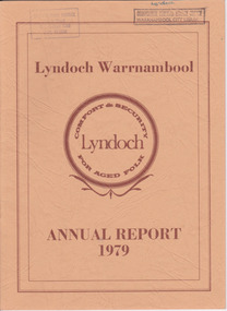
Document - Lyndoch Warrnambool 1979 Annual Report, 1979
... Rolfe acquired the land in the 1870s and named the property Lyndoch after the town in the Barossa Valley where he had lived. He owned Lyndoch for 44 years and it was his stepdaughter, Florence Lake who built in the 1920s the bungalow known as Lyndoch which forms the original building of the Lyndoch Home for the Aged. ...Rolfe acquired the land in the 1870s and named the property Lyndoch after the town in the Barossa Valley where he had lived. He owned Lyndoch for 44 years and it was his stepdaughter, Florence Lake who built in the 1920s the bungalow known as Lyndoch which forms the original building of the Lyndoch Home for the Aged. ...This is the 1979 Annual Report for Lyndoch Home and Hospital for the Aged, Warrnambool. It contains lists of Board Members, a President’s Report, a sketch of a proposed new building, financial reports, photographs and a list of Life Governors. Lyndoch Home for the Aged was established in 1952 and has developed with a wide range of facilities for the aged since that date. The original Lyndoch property near the mouth of the river Hopkins was owned by a Melbourne tea merchant, George Rolfe, who bought the land when there were only on the site a couple of cottages and a larger building which had been a school, Warrnambool Grammar, run by Henry Kemmis. Rolfe acquired the land in the 1870s and named the property Lyndoch after the town in the Barossa Valley where he had lived. He owned Lyndoch for 44 years and it was his stepdaughter, Florence Lake who built in the 1920s the bungalow known as Lyndoch which forms the original building of the Lyndoch Home for the Aged. Today the facility is called Lyndoch Living.This report is kept for the benefit of researchers wanting details of the history of Lyndoch over the past thirty or forty years.This is a booklet with a cardboard buff-coloured cover. There are six double-sided pages with printed material on white paper with a yellow and orange stripe across the top of the pages.On front cover: Lyndoch Warrnambool, Annual Report 1979 In brown circle on front cover: Lyndoch, Comfort and Security for Aged Folk Two library stamps on front cover (Warrnambool Library) lyndoch, aged care facility, warrnambool, hopkins, warrnambool grammar -
 Warrnambool and District Historical Society Inc.
Document - Lyndoch Warrnambool 1982 Annual Report
... Rolfe acquired the land in the 1870s and named the property Lyndoch after the town in the Barossa Valley where he had lived. He owned Lyndoch for 44 years and it was his stepdaughter, Florence Lake who built in the 1920s the bungalow known as Lyndoch which forms the original building of the Lyndoch Home for the Aged, Today the facility is called Lyndoch Living. ...Rolfe acquired the land in the 1870s and named the property Lyndoch after the town in the Barossa Valley where he had lived. He owned Lyndoch for 44 years and it was his stepdaughter, Florence Lake who built in the 1920s the bungalow known as Lyndoch which forms the original building of the Lyndoch Home for the Aged, Today the facility is called Lyndoch Living. ...This is the 1982 Annual Report for Lyndoch Home and Hospital for the Aged, Warrnambool. It contains lists of Board Members, a President’s Report, Lyndoch’s Aims, financial reports, photographs and a list of Life Governors. Lyndoch Home for the Aged was established in 1952 and has developed with a wide range of facilities for the aged since that date. The original Lyndoch property near the mouth of the Hopkins River was owned by a Melbourne tea merchant, George Rolfe, who bought the land when there were on the site only a couple of cottages and a larger building which had been a school, Warrnambool Grammar, run by Henry Kemmis. Rolfe acquired the land in the 1870s and named the property Lyndoch after the town in the Barossa Valley where he had lived. He owned Lyndoch for 44 years and it was his stepdaughter, Florence Lake who built in the 1920s the bungalow known as Lyndoch which forms the original building of the Lyndoch Home for the Aged, Today the facility is called Lyndoch Living. This 1982 report is kept for the benefit of researchers wanting details of the history of Lyndoch over the past 30 or 40 years. This is a booklet with a plasticized cover with a white back and a multi-coloured front cover. The front cover has a photograph of a Lyndoch building. There are six double-sided pages with printed material and photographs on white paper and a yellow and orange strip across the top of the pages. The pages are stapled.On front cover: Lyndoch Warrnambool Annual Report 1982 Stamp of Warrnambool Library On back cover: A red circle with the words ‘Lyndoch, Comfort and Security for Aged Folk’ lyndoch aged care facility, warrnambool, lyndoch warrnambool -
 Warrnambool and District Historical Society Inc.
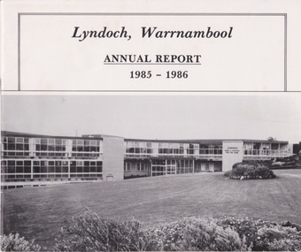
Document - Lyndoch Warrnambool Annual Report 1985-86, 1986
... Rolfe acquired the land in the 1870s and named the property Lyndoch after the town in the Barossa Valley where he had lived. He owned Lyndoch for 44 years ad it was his stepdaughter Florence Lake who built in the 1920s the bungalow known as Lyndoch which forms the original building of Lyndoch Home for the Aged. ...Rolfe acquired the land in the 1870s and named the property Lyndoch after the town in the Barossa Valley where he had lived. He owned Lyndoch for 44 years ad it was his stepdaughter Florence Lake who built in the 1920s the bungalow known as Lyndoch which forms the original building of Lyndoch Home for the Aged. ...This is the 1985-6 Annual Report for Lyndoch Home and Hospital for the Aged, Warrnambool. It contains lists of Board Members, a President’s Report, photographs, Lyndoch’s Aims, financial reports and a list of Life Governors. Lyndoch Home for the Aged was established in 1952 and has developed with a wide range of facilities for the aged since that date. The original Lyndoch property near the mouth of the River Hopkins was owned by a Melbourne tea merchant, George Rolfe, who bought the land when there were on the site only a couple of cottages and a larger building which had been a school, Warrnambool Grammar, run by Henry Kemmis. Rolfe acquired the land in the 1870s and named the property Lyndoch after the town in the Barossa Valley where he had lived. He owned Lyndoch for 44 years ad it was his stepdaughter Florence Lake who built in the 1920s the bungalow known as Lyndoch which forms the original building of Lyndoch Home for the Aged. Today the facility is called Lyndoch Living. This 1985-6 report is kept for the benefit of researchers wanting details of the history of Lyndoch over the past 30 or 40 years.This is a booklet with a plasticized white cover with a black and white photograph of a Lyndoch building on the front cover. There are eight double-sided pages with printed material and photographs. The pages are stapled.On front cover: ‘Lyndoch, Warrnambool, Annual Report, 1985-1986 On back cover: A black circle with the words: ‘Lyndoch, Comfort and Security for Aged Folk’. lyndoch aged care facility, warrnambool -
 Warrnambool and District Historical Society Inc.
souvenir cup, Warrnambool Congregational Church
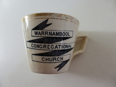
... It remained on this site until the site was sold to the T & G Assurance in 1939 and land known as Kianga Estate was purchased on the corner of Lava and Henna Streets.It became part of the amalgamation with other churches to form the Uniting Church in 1977.This cup is possibly a souvenir from the 50th anniversary celebrations held in 1912. ...It remained on this site until the site was sold to the T & G Assurance in 1939 and land known as Kianga Estate was purchased on the corner of Lava and Henna Streets.It became part of the amalgamation with other churches to form the Uniting Church in 1977.This cup is possibly a souvenir from the 50th anniversary celebrations held in 1912. ...The Warrnambool Congregational Church was established with a meeting called in April 1862 and over the ensuing months a congregation with first pastor Rev W Pentland was established. After initially meeting at the small Temperence Hall in Liebig St, land was purchased at the corner of Liebig and lava St and the first church opened in March 1864. It remained on this site until the site was sold to the T & G Assurance in 1939 and land known as Kianga Estate was purchased on the corner of Lava and Henna Streets.It became part of the amalgamation with other churches to form the Uniting Church in 1977.This cup is possibly a souvenir from the 50th anniversary celebrations held in 1912. A common object which is linked to one of warrnambool's longest running churches.Cream china cup with thick gold rim and black test in banner style on one side of the cup. Warrnambool Congregational Church on front of cup . 338 written on bottom and 4 on paper labelwarrnambool, warrnambool congregational church -
 Warrnambool and District Historical Society Inc.
Plate, Rolfe dinner plates x 4, 1864
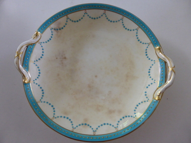
... land at the mouth of the Hopkins River in Warrnambool from the 1880s on as a holiday home. He developed the property over the years, adding a windmill and reservoir, bone and chaff sheds, a stable, jetty and boathouse and an extensive garden. In 1891 he married Mrs Annie Lake and it was his stepdaughter, Florence Lake who built the house, Lyndoch in the 1920s. This building today forms...land at the mouth of the Hopkins River in Warrnambool from the 1880s on as a holiday home. He developed the property over the years, adding a windmill and reservoir, bone and chaff sheds, a stable, jetty and boathouse and an extensive garden. In 1891 he married Mrs Annie Lake and it was his stepdaughter, Florence Lake who built the house, Lyndoch in the 1920s. This building today forms ...These dishes were part of a crockery set used in the George Rolfe household at Lyndoch, Warrnambool. George Rolfe (1836-1919) was a Melbourne tea merchant who acquired land at the mouth of the Hopkins River in Warrnambool from the 1880s on as a holiday home. He developed the property over the years, adding a windmill and reservoir, bone and chaff sheds, a stable, jetty and boathouse and an extensive garden. In 1891 he married Mrs Annie Lake and it was his stepdaughter, Florence Lake who built the house, Lyndoch in the 1920s. This building today forms part of an Aged Care Facility. This item is part of the larger Rolfe dinner set as described on Victorian Collections at VC001421 and VC001422These dishes are of importance as they belonged to the George Rolfe family of Lyndoch, Warrnambool. They demonstrate the quality of the household goods used by more affluent families in the second half of the 19th century. These are four china serving dishes or plates which are part of a set of crockery used in the Rolfe Lyndoch household in Warrnambool. The dishes have a circular base with a circular dish resting on the base. The dishes have or had two handles with these handles and the edges of the dishes being gold trimmed. Around the rim of the dishes is a pattern of loops and dots etc of teal and gold. One dish (.1) has no handles, one dish (.4) has one handle only and two dishes are cracked (.3 & .4) . Two dishes are stained, one severely (.2 & .4) ‘Minton’ george rolfe, florence lake -
 Warrnambool and District Historical Society Inc.
China, Cups x 4, 1864
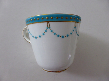
... land at the mouth of the Hopkins River in Warrnambool from the 1880s on as a holiday home. He developed the property over the years, adding a windmill and reservoir, bone and chaff sheds, a stable, jetty and boathouse and an extensive garden. In 1891 he married Mrs Annie Lake and it was his stepdaughter, Florence Lake who built the house, Lyndoch in the 1920s. This building today forms...land at the mouth of the Hopkins River in Warrnambool from the 1880s on as a holiday home. He developed the property over the years, adding a windmill and reservoir, bone and chaff sheds, a stable, jetty and boathouse and an extensive garden. In 1891 he married Mrs Annie Lake and it was his stepdaughter, Florence Lake who built the house, Lyndoch in the 1920s. This building today forms ...These dishes were part of a crockery set used in the George Rolfe household at Lyndoch, Warrnambool. George Rolfe (1836-1919) was a Melbourne tea merchant who acquired land at the mouth of the Hopkins River in Warrnambool from the 1880s on as a holiday home. He developed the property over the years, adding a windmill and reservoir, bone and chaff sheds, a stable, jetty and boathouse and an extensive garden. In 1891 he married Mrs Annie Lake and it was his stepdaughter, Florence Lake who built the house, Lyndoch in the 1920s. This building today forms part of an Aged Care Facility. This item is part of the larger Rolfe dinner set as described on Victorian Collections at VC001421 and VC001422These cups are part of a crockery set, and are kept because they belonged to George Rolfe, a prominent property owner and farmer in Warrnambool in the late 19th century and early 20th century. The items, dating from 1864, have social significance showing the type of crockery used by a more affluent family in the 19th century.Four small white cups decorated with aqua band around the top of each cup . A scalloped pattern of dots are suspended from the solid band which is decorated with a row of gold dots. There is a gold rim at the base of the cup.Mintonrolfe, lyndoch, warrnambool, minton cups, mrs annie lake