Showing 145 items matching " nepean road/highway"
-
 Chelsea & District Historical Society Inc
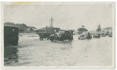
Photograph - Chelsea Flood December 1934, Point Nepean Road (Nepean Highway)
... Point Nepean Road (Nepean Highway)...Nepean Highway...Point Nepean Road...Black and white photo of flood waters across Point Nepean Road (now Nepean Highway). Cars and trucks are driving through the water....Cars and trucks are driving through the water. Point Nepean Road (Nepean Highway) Photograph Chelsea Flood December 1934 ...In December 1934, 700 houses were inundated with water, when the Dandenong Creek and Patterson River broke their banks.Black and white photo of flood waters across Point Nepean Road (now Nepean Highway). Cars and trucks are driving through the water.flood, chelsea, dandenong creek, nepean highway, point nepean road -
 Chelsea & District Historical Society Inc
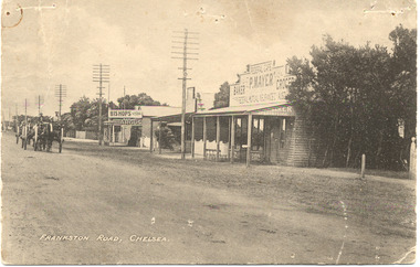
Photograph - Main Road (now Nepean Highway) Chelsea, c 1915
... Main Road (now Nepean Highway) Chelsea...Black and white postcard of the main road, Chelsea (now Nepean Highway) showing P. Mayer's Store and Bishop's Store. ...Photograph Main Road (now Nepean Highway) Chelsea ...Black and white postcard of the main road, Chelsea (now Nepean Highway) showing P. Mayer's Store and Bishop's Store. Bishop's store is on the corner of Wimbourne Avenue, Chelsea. The road is unmade and two wagons are traveling down the road.Frankston Road, Chelseachelsea, mr p. mayer, mr bishop, wagons -
 Glen Eira Historical Society
Document - BOX FAMILY
... ... Nepean Road/Highway...Kilda Road Nepean Road/Highway McKinnon Ormond Carnegie Oakleigh Murrumbeena Moorabbin Mordialloc Heathcote Bentleigh Brighton East Manchester Road Brighton Council City of Moorabbin West Joseph Porter Harriet Moore Henry Moeller A (Moller) Box Mary Lindsay McCurry Elizabeth Lindsay Elizabeth Lindsay Henry Lindsay Frederick Schmidt William Robilliard James Cpt. ...Extensively detailed family history from 1838 in UK to present day. Provides much local history and social history into early pioneering and market gardening families. Forty one page computer print out with numerous black and white photographs.box w.h. george, box george, box mary nee cripps, box caroline, box william, box henry, box john, box anna, box eliza, box elizabeth nee avis, box francis, box lydia, moeller a., mclean n., robilliard george james, box ester, box fanny (downard), box eleanor, philbrick richard, fairlam richard, hale jasper, dendy henry, renick mark, renick stefanie (nee riemann), brighton cemetery, ormond, east brighton, prahran, centre road, jasper road, manchester road, mckinnon road, north road, brighton, box cottage, moorabbin historical society, thomas street, elsternwick, paterson road, east bentleigh, tucker road, jasper road, harwood thomas, box violet, hordeen lebbens, augustus arthur, wattle, pioneers, ancient order of foresters, council of moorabin, elster creek, primitive methodist church, lewis’ timber yard, grape growing, paling house, wells, water wagon, market gardens, farming, aboriginal people, king billy, chinese, kayon (?), kay you (yu?), cheong ki, boxer rebellion, chinese missionary, brickmakers, midwife, corben’s monumental masons, sculptor, cottage, parlour, verandah, scullery, le man’s swamp, flower nursery, chook houses, ladies college, moorabbin roads board, western market, eastern market, victoria market, st. kilda road, nepean road/highway, mckinnon, ormond, carnegie, oakleigh, murrumbeena, moorabbin, mordialloc, heathcote, bentleigh, brighton east, manchester road, brighton council, city of moorabbin, west joseph, porter harriet, moore henry, moeller a (moller), box mary, lindsay mccurry elizabeth, lindsay elizabeth, lindsay henry, lindsay frederick, schmidt william, robilliard james cpt., beckett ida, beckett nellie, beckett martha, beckett martha maud, robinson eleanor, robinson joyce, dowling thomas, anderson william snowden, mccurry henry mr & mrs, box emily jane (nee mccurry), jorgensen justin, jorgensen dr., jorgenson bertha, ross william murray, st. kilda, merrie creek, pentridge (now coburg), murray road, wyuna dunoos st, grange road, rosstown, tucker rd, elizabeth st, common school no 213 east brighton, bentleigh, steel roads tracks, rabbits, cheltenham, brighton cemetery, cheltenham cemetery, paterson road, east boundary road, baptist church, lay preachers, missionaries- china, oakleigh tyre works, belfast hotel sandhurst (bendigo), mornington, gas street lighting, brighton historical society, moorabbin primary school, bravis road, lewis street, chalmers street, grange road, butcher shops, ormond state school, oakleigh council, wedding dress, methodist children’s home cheltenham, bentleigh baptist church, auctioneer, lindsay mark, balkham jane, balkham stephen, reitman august william, fitzwilliam catherine, quashdorf (?phonetic) mr, box violet, montford paul, reitman stephanie (renick mrs), reitman william, box ada, downard alicia (lill), downard arthur, downard edward, graham elizabeth, downard octavia rose, downard william alfred, downard arthur henry (harvey), downard fanny, thompson eliza jane, box lena caroline, viloudaki rebecca, box anna (pay), pay henry, box eliza (gurr), johnson geoffrey, rushall eleanor (nellie), gurr eliza nee box, gurr jabez henry tasman, marriot william mrs, ross william murray, box gladys (nee battersby), box dulcie (bussell), bussell samuel robert, bussell norma (hoult), bussell darren lyle, bussell craig andrew, bussell sylvia june (barry), barry j. haydon, barry rachael alexandra, barry phillipa anne, barry vanessa kate, bussell joan lorraine (millie), millie john, bussell harold leslie, euston mr, purdue edgar robert, box lydia elizabeth, wilkinson coral doreen, mitchell donald, centre road, court pride of st george aof, dunoon street, vickery street, darey street/ave., oakleigh state school, methodist church, mill street, koornang road, regent street, marriage road, box olivia christina, box ernest charles, box walter william, lawson robert, lawson nancy eunice (curtis), box walter stanley, box eleanor (nellie) rushall, box martha, box john, box nellie gladys, andrews william (bill), box ray, mccurry mrs elizabeth, box william henry george, schreiber family, jorgensen family, downward arthur, downward alicia – lill, downward octavia rose, downward william alfred, downward arthur henry/harvey, cummings ida, cummings william, downward alice (nee cleary), downward ada, downward lucy (mrs bailey), downward alice, downward arthur harvey, bailey lawrence, bailey ian, bailey carol viola (bartlett), bailey colin harvey, bailey julie alison (hardware), bailey val, bailey adina, bailey david, bartlett brian, bartlett bradley grant, bartlett clayton lawrence, hardware michael, hardware dion michael colin, hardware jevon michael bailey, box elanor, box alice amelia (dale), dale george, dale elizabeth, dale lilly, dale john, dale thomas, dale rose, dale ethelbert, dale george, dale elsie, box thomas henry, box annie lavinia (rogers), rogers annie elizabeth, rogers william richard, box arthur walter, nelson dagma marie (box), box walter kingston, box marie, box cecilia eliza (ainger), ainger james, box ida may, cumming william george, cumming wendy (nee mansell), cumming susan, cumming paul, cumming felicity (steel), cumming shane, cumming melissa, cumming angel, box harold, box dorothy may (jackson), jackson frederick, jackson margaret (walker), jackson judith, walker david, walker michelle (neville), neville andrew, walker darren, walker rebecca (coyne), walker joshua, walker bradley, johnson steven, johnson carl, johnson judith (jackson), johnson peter, johnson melissa (hamid), johnson craig, ely johnson/jackson judith, ely steven, linham arthur, box thelma elizabeth (eagle), eagle keith, eagle nancye elizabeth (harpin), harkin john, harkin mary anne (howe), howe barry, howe samuel, harkin michael, harkin christopher, harkin elizabeth, eagle roddan, eagle carolyn (mansell), eagle gerard, eagle kerri – lee, box avis ann (eldridge), eldridge alf, eldridge robert, eldridge sandra, eldridge adam, eldridge nicholas, eldridge patric, eldridge john, eldridge carol (biggs), eldridge robert james, eldridge catherine elizabeth, eldridge meredith, box william john, box maud (nee hanchette), box malcome, box sandra (ede), box stephen, box nicolle, box andrew, box christine (dormer), box corrina, box jennifer (turpin), turpin phillip, box herbert, box olwyn (richard), box elaine henry, henry bruce, henry james, henry robin, henry david, box richard, box nerida (bowen), box duncan, box john, box cerwiden, box ewan, box bryan, box collen (malony), box kieran, box eden, box christopher, box pam (smith), box sue (tirchett), box thomas, box william, box george frederick, box olive (cameron), box eliza jane (thompson), box francis george, box lena caroline, box-hembrow mable alma, box charles francis, clinch mr., box robinson jessie melinda, box clay edith florence, north brighton, waun alex, waun robert, marquis peter, sheppard w., warnbach mr, marriott william mrs, box dorothy (seabrook), box hazel, box jessie, box frank (francis), seabrook len, box henry, seabrook albert, seabrook stanley allan, barry j. haydon, barry rachel alexandra, millie john, bussell harold leslie, bussell sue, bussell leanne melinda, bussell benjamin leslie, bussell lynette, box george, box jean (holms), box george, box alisa (hughes), hughes justin, hughes ebony, hughes tasman, box robin, box veronica (roman), box andrea roman, box lisa roman, box jodi roman, box malcome, box sue (kerrison), box amanda, box anthony, clay john (jack) francis, clay lynda blanche (nee sibte), clay vivien, clay majory joy, lipman vernon (vern) ronald, clay kenneth graham, clay laura jean -
 City of Moorabbin Historical Society (Operating the Box Cottage Museum)
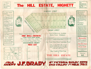
Flyer - Hill Estate, Highett
... Point Nepean Road (Nepean Highway)...Example of the progress of the Municipality of Moorabbin Point Nepean Road (Nepean Highway) Turner Street Sanford Street Real Estate Highett The Hill Estate, Highett - 24 Housing Blocks - J. ...Land sales in the Municipality of Moorabbin increased when the train line from the City to Frankston was electrified.Example of the progress of the Municipality of MoorabbinAdvertising flyer for auction of real estate sales - plan of building blocks for saleThe Hill Estate, Highett - 24 Housing Blocks - J. F. Bradypoint nepean road (nepean highway), turner street, sanford street, real estate, highett -
 City of Moorabbin Historical Society (Operating the Box Cottage Museum)
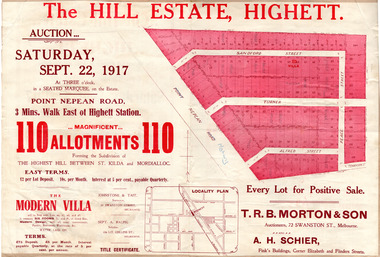
Flyer - The Hill Estate, Highett, 1917
... Point Nepean Road (Nepean Highway)...Example of the progress of the Municipality of Moorabbin Point Nepean Road (Nepean Highway) Turner Street Sanford Street Alfred Street Peace Street Highett Real Estate Moorabbin The Hill Estate, Highett - 110 allotments - Auction Saturday September 22, 1917 T.R.B. ...The land sales in the area stopped due to the 1890s depression. For the next 20 years real estate sales virtually stopped until after WWI.Example of the progress of the Municipality of MoorabbinAdvertising flyer for auction of real estate sales - plan of building blocks for saleThe Hill Estate, Highett - 110 allotments - Auction Saturday September 22, 1917 T.R.B. Morton & Sonpoint nepean road (nepean highway), turner street, sanford street, alfred street, peace street, highett, real estate, moorabbin -
 City of Moorabbin Historical Society (Operating the Box Cottage Museum)
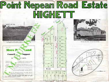
Flyer - Point Nepean Road Estate, Highett, 1937
... Point Nepean Road (Nepean Highway)...Example of the progress of the Municipality of Moorabbin Point Nepean Road (Nepean Highway) Alison Street William Street Point Nepean Road Estate, Highett T.M. ...Land sales in the Municipality of Moorabbin increased when the train line from the City to Frankston was electrified.Example of the progress of the Municipality of MoorabbinAdvertising flyer for auction of real estate sales - plan of building blocks for sale, pictures of landmarks.Point Nepean Road Estate, Highett T.M. Bourkepoint nepean road (nepean highway), alison street, william street -
 City of Moorabbin Historical Society (Operating the Box Cottage Museum)
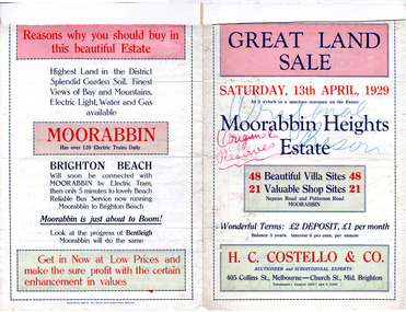
Flyer - Moorabbin Heights Estate, Moorabbin, 1929
... Point Nepean Road (Nepean Highway)...Example of the progress of the Municipality of Moorabbin Point Nepean Road (Nepean Highway) Harding Street Howell Street North Avenue Coates Street Moorabbin Heights Estate, Moorabbin 48 Villa sties, 21 Shop sites Sale on Saturday 13 April 1929 - H. ...The train line from the city to Frankston was electrified which intensified the sale in the municipality of Moorabbin, particularly land which was in the vicinity of the railway stations.Example of the progress of the Municipality of MoorabbinAdvertising flyer for auction of real estate sales - plan of building blocks for saleMoorabbin Heights Estate, Moorabbin 48 Villa sties, 21 Shop sites Sale on Saturday 13 April 1929 - H. C. Costello & CO.point nepean road (nepean highway), harding street, howell street, north avenue, coates street -
 City of Moorabbin Historical Society (Operating the Box Cottage Museum)
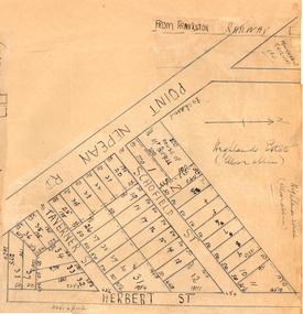
Plan - Highlands Estate, Moorabbin
... Point Nepean Road (Nepean Highway)...Example of the progress of the Municipality of Moorabbin Point Nepean Road (Nepean Highway) Schofield Street Taverner Street Herbert Street (now Linton Street) moorabbin real estate auction Highlands Estate, Moorabbin plan. ...The train line from the city to Frankston was electrified in 1922 which intensified the sale in the municipality of Moorabbin, particularly land which was in the vicinity of the railway stations. This estate was auctioned on Saturday, October 20, 1923.Example of the progress of the Municipality of MoorabbinAdvertising flyer for auction of real estate sales - plan of building blocks for saleHighlands Estate, Moorabbin plan.point nepean road (nepean highway), schofield street, taverner street, herbert street (now linton street), moorabbin, real estate, auction -
 Chelsea & District Historical Society Inc
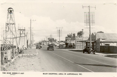
Photograph - Shopping Area, Aspendale, c 1930's
... Nepean Road...Nepean Highway...Chelsea & District Historical Society Inc The Chelsea Activity Hub 3-5 Showers Ave Chelsea 3196 melbourne Point Nepean Road Nepean Highway Aspendale Taylor Avenue shops Aspendale fire station Aspendale Picnic Grounds The Rose Series P. 1037 MAIN SHOPPING AREA IN ASPENDALE, VIC. ...Black and white postcard showing shops on the right hand side of Point Nepean Road and the railway line, Aspendale railway station and the Aspendale Fire Station with the bell tower beside it. One car driving along the road and two cars parked. The shops in view are a cafe, a general store, the Aspendale Picnic Grounds, which included Palais De Dance.The Rose Series P. 1037 MAIN SHOPPING AREA IN ASPENDALE, VIC.point nepean road, nepean highway, aspendale, taylor avenue, shops, aspendale fire station, aspendale picnic grounds -
 Chelsea & District Historical Society Inc
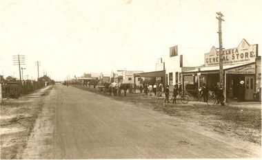
Photograph - Point Nepean Road, Chelsea
... Nepean Road...Nepean Highway...Chelsea & District Historical Society Inc The Chelsea Activity Hub 3-5 Showers Ave Chelsea 3196 melbourne Chelsea Point Nepean Road Nepean Highway railway Black and white photo of Chelsea, showing Point Nepean Road, the railway line, people, shops, horse and cart and bicycles. ...Black and white photo of Chelsea, showing Point Nepean Road, the railway line, people, shops, horse and cart and bicycles. Chelsea Railway Station can be seen in the distance. Shops that can be identifies are the Chelsea General Store, J & C Caudwell and Timber Merchant.chelsea, point nepean road, nepean highway, railway -
 Chelsea & District Historical Society Inc
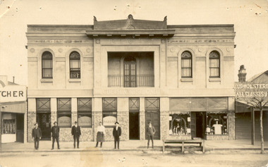
Photograph - Chelsea Shops, Butcher shop - Chelsea Wine Bar - Upholsterer, 1920's
... Nepean road...Nepean Highway...Nepean Highway opposite the Chelsea railway station. It offered meals, accommodation and wine. In late 1936 the building was pulled down. Chelsea Chelsea Wine Cafe Point Nepean road ...The Chelsea Wine Cafe was situated in Point Nepean Highway opposite the Chelsea railway station. It offered meals, accommodation and wine. In late 1936 the building was pulled down.Two black and white photos of Chelsea Wine Cafe also in the photos are a butcher shop and an upholsterer.Chelsea Wine Cafe Cash Butcher Upholsterer - All classes of Furniture chelsea, chelsea wine cafe, point nepean road, nepean highway -
 City of Kingston
Photograph - Black and white, c. 1950
... The intersection of Warrigal Road and Nepean Highway is now a major intersection, serviced by traffic lights. ...Black and white photograph of the intersection of Warrigal Road and Nepean Highway, Mentone. ...City of Kingston Parkdale Library 96 Parkers Road, Parkdale Parkdale The intersection of Warrigal Road and Nepean Highway is now a major intersection, serviced by traffic lights. ...The intersection of Warrigal Road and Nepean Highway is now a major intersection, serviced by traffic lights. In the 1950s it was a joining of two sealed roads, although covered in gravel, and with wide gravel shoulders. There are no traffic signs and the few houses visible are not set very far back from the road. This image is one of many in the collections that focuses on either roads or the railway. The development of roads and the railway was crucial to the ongoing development of the area.Black and white photograph of the intersection of Warrigal Road and Nepean Highway, Mentone. Handwritten in blue ink on reverse: 218 Handwritten in red ink on reverse: 75%mentone, roads, suburbs -
Glen Eira Historical Society
Book - Local Government Act First Report of the Assistant Commissioner of Roads and Bridges
... Nepean Road... Nepean Highway...F. the Honourable Caulfield Moorabbin Road Districts Point Nepean Road Nepean Highway Dandenong Road Princes Highway Brown Edwin Osher Joseph Cosgrove John Ferres John Roads and Bridges Offices Caulfield Roads District Moorabbin Roads District Road Construction and Maintenance Roads and Streets Acts of Parliament Book Local Government Act First Report of the Assistant Commissioner of Roads and Bridges ...This file contains 1 item: 1/The Local Government Act, First Report of the Assistant Commissioner of Roads and Bridges, printed by order of the Victorian Legislative Assembly on 08/03/1865. The document is the first annual report of John Steavenson, Assistant Commissioner of Roads and Bridges under s330 of the Local Government Act no. 176 (1863), and relates to transactions which took place from 02/09/1863 to 31/12/1864. The report outlines operations carried out by the Department of Roads and Bridges in this period. In the Glen Eira area this includes: separating electoral subdivisions of single districts (Moorabbin), adding detached portions of territory to road districts and shires (Caulfield), appointing of and altering in polling places, appointing of polling places for ridings of shires and subdivisions of road districts (Moorabbin), preparing and transmitting of forms of books also of pro forma accounts for guidance of local bodies in keeping their accounts, appointment of main roads, construction of a main road, ‘Dandenong’, in the Caulfield and Gardiner districts, proclaiming of Common Toll Roads, names of and security given by Managers of Common Toll Roads. The report also gives some information about the Shire of Caulfield, which contained 24 road districts and 340 rate payers in 8¼ square miles, and the Shire of Moorabbin, which contained 62 road districts and 713 rate payers in 30 square miles.local government act, assistant commissioner of roads and bridges, legislative council, caulfield historical soceity, steavenson john, sullivan j. f. the honourable, caulfield, moorabbin, road districts, point nepean road, nepean highway, dandenong road, princes highway, brown edwin, osher joseph, cosgrove john, ferres john, roads and bridges offices, caulfield roads district, moorabbin roads district, road construction and maintenance, roads and streets, acts of parliament -
 City of Moorabbin Historical Society (Operating the Box Cottage Museum)
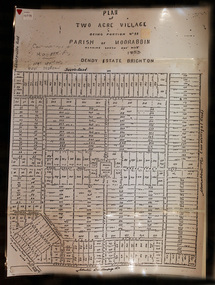
Document,photocopy plan 'Two Acre Village 'c1852, c1960
... John, Holloway Josiah, whorral charles, arthur’s seat road, nepean highway , Cheltenham inn hotel, henry dendy special survey 1841...In the 1852 Josiah Holloway, a developer, purchased 625 acres from the squatters Richard and John King and sectioned '2 acre allotments' south of Henry Dendy's Brighton Survey along the Arthur's Seat Road ( later Nepean Highway) for sale @ £10 It became known as The Two Acre Village as settlers took up the allotments and established market gardens, general stores, butchers, blacksmiths, post office and 2 hotels. ...John, Holloway Josiah, whorral charles, arthur’s seat road, nepean highway , Cheltenham inn hotel, henry dendy special survey 1841 A photocopy of the Plan for the 2 Acre Village in Moorabbin Parish c1852. ...In the 1852 Josiah Holloway, a developer, purchased 625 acres from the squatters Richard and John King and sectioned '2 acre allotments' south of Henry Dendy's Brighton Survey along the Arthur's Seat Road ( later Nepean Highway) for sale @ £10 It became known as The Two Acre Village as settlers took up the allotments and established market gardens, general stores, butchers, blacksmiths, post office and 2 hotels. Charles Whorral opened The Cheltenham Inn and it became so popular as a meeting place that the area was called Cheltenham. The early settlers, who were predominantly English and Scottish immigrants initially leased their allotments and, because the sandy soil was so fertile, they were soon able to purchase the land and increase their acreage. Cheltenham became a very important part of the large Moorabbin Shire1871 and City of Moorabbin 1934 In the 1994 Amalgamation of Councils, when the large City of Moorabbin was divided between the newly formed Glen Eira, Kingston and Bayside Councils, the Cheltenham area was assigned to the City of Kingston A photocopy of the Plan for the 2 Acre Village in Moorabbin Parish c1852. A3 laminatedmoorabbin, brighton, cheltenham, market gardeners, pioneers, early settlers, , king. john, holloway josiah, whorral charles, arthur’s seat road, nepean highway , cheltenham inn hotel, henry dendy special survey 1841 -
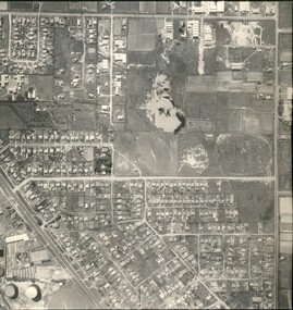
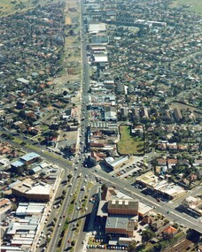 City of Kingston
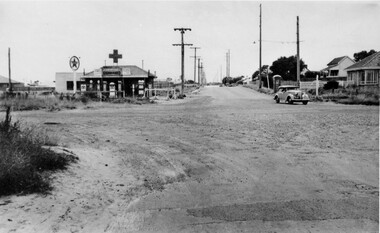
Photograph - Colour, c. 1982
... Nepean Highway...South Road...This aerial photograph of South Road and Nepean Highway, Moorabbin shows the area where houses and shops on the south side of the Nepean Highway have demolished for the widening of the highway. ...Colour photograph of an aerial view of South Road and Nepean Highway, Moorabbin. The image shows houses on the south side of the Nepean Highway that have demolished for widening of road. ...City of Kingston Parkdale Library 96 Parkers Road, Parkdale Parkdale This aerial photograph of South Road and Nepean Highway, Moorabbin shows the area where houses and shops on the south side of the Nepean Highway have demolished for the widening of the highway. ...This aerial photograph of South Road and Nepean Highway, Moorabbin shows the area where houses and shops on the south side of the Nepean Highway have demolished for the widening of the highway. The pressures of rapid urban development in Moorabbin and beyond, especially to the south of Moorabbin caused bottlenecks and delays, especially at the South Road and Nepean Highway intersection, hence the scheme to widen Nepean Highway.The pressures of rapid urban development in terms of people, housing construction, industrial development and commercial activity, in Moorabbin and beyond, especially to the south would put pressure on road infrastructure in the region. In the early 1980s, a major road expansion of the Nepean Highway was implemented to increase capacity on this major thoroughfare for vehicle commuters. Car use had also increased with commuters from the increasingly populous southern suburbs travelling to their place of work in the Melbourne CBD.Colour photograph of an aerial view of South Road and Nepean Highway, Moorabbin. The image shows houses on the south side of the Nepean Highway that have demolished for widening of road. It features housing and commercial buildings looking north towards Cummins Road.Handwritten blue ink: 82 - 5452 - 11 Handwritten red ink: 112% Handwritten black ink: Ch. 7nepean highway, south road, moorabbin, roads, transport, infrastructure -
Glen Eira Historical Society
Book - CAULFIELD CENTENARY 1957
... Road... Nepean Highway...Ward boundaries Dandenong Road Queens Avenue Normanby Road Station Street Bond Street Glen Eira Road Orrong Road Poath Road North Road Booran Road Nepean Highway Glen Huntly Road Glenhuntly Road Inkerman Road Hotham Street Nelson H.G. ...This file contains four items 1/Two copies of a twenty-four page booklet titled CITY OF CAULFIELD CENTENARY 1857-1957, created by the Caulfield City Council and printed by Peter Isaacson Pty Limited, Melbourne. The booklet details important aspects of Caulfield’s history including council procedures, the Caulfield Road District Proclamation, the first election and a summary of 100 years of local government with a description of the present Caulfield in 1957. The booklet also includes several pictures of various Caulfield landmarks and people including one of Caulfield City Councillors (11 men and 1 woman). Also one photocopied version of this booklet. 2/Eleven pages of typed notes for the City of Caulfield Centenary booklet. All notes are undated and incomplete. Two pages titled NOTES on THE HISTORY and PROGRESS OF THE CITY OF CAULFIELD, author unknown. Three and a half pages titled THE STRUCTURE OF LOCAL GOVERNMENT IN VICTORIA, author unknown. Five pages titled 100 YEARS OF LOCAL GOVERNMENT – EARLY CAULFIELD, by Mrs A. P. Bell. 3/A typed letter to Miss V. Webb-Langdon from the Town Clerk H.G. Nelson, acknowledging her contribution to historical details for the Caulfield Council’s Centenary booklet, dated 24/12/1957. 4/A handwritten letter and a handwritten note regarding the acquisition of notes for the Caulfield Centenary booklet. The letter is dated 03/08/2006 and the note is dated 09/02/2007.city of caulfield centenary, caulfield road district, sinclair a.j.g., city hall, war memorials, gamble h.a., machin l.r., bunny f.c.d., caulfield park, koornang reserve, parton e.m., sims h.e., thomson w.r., gunn e.e., yorston j.s., wallace g.e. mrs, green w.c., jenner e.r., ward boundaries, dandenong road, queens avenue, normanby road, station street, bond street, glen eira road, orrong road, poath road, north road, booran road, nepean highway, glen huntly road, glenhuntly road, inkerman road, hotham street, nelson h.g., fullard w.r., mackley g.j., ellis k.i, crosbie m.r., nutting b.i., body j.h., pritchard r.j., guildford l.t.g., lund l.m., street h.c., reynolds a.w., elections , political processes, local government, springthorpe reserve, greenmeadows gardens, business and finance, roads and streets, caulfield racecourse, east caulfield reserve, mackinnon reserve, hawthorn road, balaclava road, murrumbeena road, lempriere avenue, victoria street, koornang road, lord reserve, lyons street, murrumbeena reserve, kangaroo road, ormond park, beatty crescent, foch street, packer reserve, oakleigh road, leila road, prices park, bambra road, riley reserve, playgrounds, town hall, maternal and child health centres, truganini road, grange road, senior citizens centre, barkley sir henry, moore david, handasyde gilbert, caulfield school room, harris g.w., semple john, dempsey william, brooks w.a., wilson thomas, lyall william, murrum murrumbeen lifestyle, ‘greenmeadows’ house, lempriere family, aboriginal culture, ‘rippon lea’ house, caulfield john, ‘slaney’s’ home, alma road, paddy’s swamp, racecourse hotel, caulfield technical college, bevan mr., ‘grosmont’, hart john, railways, mansions, ‘rosecraddock’, langdon h. j., caulfield cup, ‘crotonhurst’, webb judge, ‘kilwinning’, service james, ricketson henry, ‘glen eira’, house names, garden vale, ross william murray, ‘ross’s folly’, outer circle railway, caulfield grammar school, davies j. henry, lagdon william, grimwade f.s., loyd charles du plan, hope george, ‘airdrie’, kooyong hill, market gardens, dairies, lady talbot milk supply, jenner family, o’niell college, presentation sisters, glenferrie road, grimwade frederick sheppard, grimwade alice, ‘harlston’, grimwade house, ‘saint aubin’s’, ‘st. aubin’s’, ‘caulfield hall’, caulfield john p.t., st georges road, caulfield military hospital, nursing homes, health establishments, dover street, sports and recreations, rosanna street, ‘cantala’, health services, parks and reserves, community services, town planning, local government finance, local officials and employees -
Glen Eira Historical Society
Document - Historic Conservation Areas Project
... Road... Nepean Highway...Caulfield Library Dandenong Road Nepean Highway Hotham Street Iknerman Road Orrong Road North Road Poath Road ‘Plan of the City of Caulfield’ North Ward East Ward South Ward West Ward Kooyong Road Neerim Road Bambra Road Balaclava Road Shire of Caulfield Railways World War 1914-1918 Depression 1929-1939 Rippon Lea Labassa Parks Mansions Community Services ‘Caulfield North Draft Heritage Guidelines July 1999’ City of Glen Eira Caulfield North Heritage Area Glen Eira Heritage Management Plan Mayfield Grove Normanby Avenue Carnarvon Street Glenferrie Street Arthur Street Malakoff Street Normanby Road Heritage Advisory Service Construction Materials Victorian Style Mediterranean Style Spanish Mission Style Californian Bungalow Style Federation Style Architectural Style Architectural Features Heritage Conservation Design Building Construction Building Regulations Aboriginal Peoples Carnarvon Road Document Historic Conservation Areas Project ...Contains 4 items relating to historic conservation: 1/Five newsletters (one page each newsletter, dated 07/1975, 08/1975, 09/1975, 10/1975 and the final one 12/1975) describing how the project evolved, project funds, progress, study method, project 1 report, project 2 report and summary as no further funds available. Project was to include all of Melbourne but funding did not allow this. Note: newsletters stamped with Caulfield Historical Society. 2/Letter (one page on official city of Caulfield letterhead) from Andrew Rodda (manager planning) to Hazal Ford (dated 13/11/1989) describing ‘council resolved on 18/07/1989 to proceed with preliminary conservation survey’ and mentions that a copy is included. 3/Preliminary conservation survey for the City of Caulfield (nine pages) describing background, study area, budget, purpose, study outline, timeframe, report format, ownership, tasks and background information (mentions number and types of houses and properties as at 1986 and 1988) and a map of City of Caulfield. 4/Booklet (28 pages) titled ‘Heritage Area – Caulfield North Draft Heritage Guidelines July 1999 – City of Glen Eira’, containing Caulfield North Heritage Area, cultural heritage, Heritage Overlay Area, architectural description, common architectural forms and features, development guidelines, key design checklist. It includes a map of the Caulfield North Heritage Overlay Area, two illustrations about the development envelope and many black-and-white photographs of houses and architectural features.historic conservation areas project niven barbara, newsletters, town planning, historic buildings, heritage studies, housing, royal historical society of victoria (rhsv), read michael, plans, local government, historical societies, committee for urban action (cua), national trust, hopkins sherry ms., ford hazel, preliminary conservation survey, town planning, heritage studies, rodda andrew, city of caulfield, housing estates, victoria national estate grants program, australia icomos, burra charter, buildings structures and establishments, land surveys, suburbs, historic buildings, architectural significance, ‘caulfield’s heritage study’, soloman geulah dr., caulfield library, dandenong road, nepean highway, hotham street, iknerman road, orrong road, north road, poath road, ‘plan of the city of caulfield’, north ward, east ward, south ward, west ward, kooyong road, neerim road, bambra road, balaclava road, shire of caulfield, railways, world war 1914-1918, depression 1929-1939, rippon lea, labassa, parks, mansions, community services, ‘caulfield north draft heritage guidelines july 1999’, city of glen eira, caulfield north heritage area, glen eira heritage management plan, mayfield grove, normanby avenue, carnarvon street, glenferrie street, arthur street, malakoff street, normanby road, heritage advisory service, construction materials, victorian style, mediterranean style, spanish mission style, californian bungalow style, federation style, architectural style, architectural features, heritage conservation design, building construction, building regulations, aboriginal peoples, carnarvon road -
Glen Eira Historical Society
Document - History of the City of Caulfield
... Road... Nepean Highway...Mary’s Church Caulfield Council Kooyong Road Neerim Road Bambra Road Greenmeadows House Caulfield Park Paddy’s Swamp Dandenong Road Caulfield Grammar School Chisholm Institute of Technology Murrumbeena Glen Eira Road Alma Road Orrong Road Balaclava Road Inkerman Road ‘Grosmont’ Caulfield School Room Caulfield Road Board Caulfield Road District Crimean War Victorian Amateur Turf Club Caulfield Cup Glenhuntly Road North Road Glenhuntly Station Ormond Station Outer Circle Railway Local Government Gardenvale Carnegie Rosstown Poath Road Nepean Highway Hotham Street Ormond Park Princes Park Ross William Murray Caulfield Institute of Technology ‘Ross’ Folly’ Hawthorn Road Glenhuntly Ormond Morris T. ...This file contains 4 items: 1/Typewritten document titled ‘The City of Caulfield’. Author and date unknown. 1 page (back and front), 2 copies. Document covers topics such as origins of the name ‘Caulfield’, early settlement and the Caulfield Cup. 2/Typewritten document titled ‘History of Caulfield Council’. Author and date unknown. 6 pages, 3 copies. Document covers subjects such as early settlement, Aboriginal influence, Caulfield Road Board, Shire of Caulfield, Borough and town boundaries, coat of arms, and Freedom of Entry to the City. 3/Typewritten document (undated + author unknown) titled ‘The Structure of Local Government in Victoria with a history of the City of Caulfield’. 13 pages. Covers the following subjects: Powers, Planning, Public Works, Trading Undertakings, Health Services, Municipalities, Wards Electors or Ratepayers, Voters Roll, Councillors, Officers, Finance, Nature of Soil and Vegetation, Parks and Gardens and Reserves, Coat of Arms, Boundaries, How Did Caulfield get its Name, Aboriginal Influence, Caulfield Road Board, Shire of Caulfield, Borough and Town and the City of Caulfield. Also covered is early settlement. Note at the end of the document mentions that the historical content contained in the last section was based upon a thesis for the Department of Town and Regional Planning, University of Melbourne, 1968 by L. Alwis, P. Rowe, N. Wootten. Melbourne, ‘City of Caulfield: An Illustrated City Report’. 4/Typewritten document (undated) titled ‘The Structure of Local Government in Victoria with notes on the history of the City of Caulfield’. 8 pages, 2 copies. This document also includes a map/diagram of the city with boundaries and wards showing locations of railway stations and parks. Document covers the structure of local government and its functions then goes on to focus on City of Caulfield with subjects similar to those covered in item 3. Document signed off by Deputy Town Clerk.city of caulfield, caulfield john, caulfield baron, caulfield racecourse, elsternwick, ripponlea, st. mary’s church, caulfield council, kooyong road, neerim road, bambra road, greenmeadows house, caulfield park, paddy’s swamp, dandenong road, caulfield grammar school, chisholm institute of technology, murrumbeena, glen eira road, alma road, orrong road, balaclava road, inkerman road, ‘grosmont’, caulfield school room, caulfield road board, caulfield road district, crimean war, victorian amateur turf club, caulfield cup, glenhuntly road, north road, glenhuntly station, ormond station, outer circle railway, local government, gardenvale, carnegie, rosstown, poath road, nepean highway, hotham street, ormond park, princes park, ross william murray, caulfield institute of technology, ‘ross’ folly’, hawthorn road, glenhuntly, ormond, morris t. w., lloyd charles du plan, meals on wheels, shire of caulfield, caulfield railway station, caulfield rsl, bouran road, murrum murrumbeen, kooyong road, great dandenong road, neerim road, trams, prahran and malvern tramways trust, fisher andrew, mackinnon reserve, dover street, ‘glen eira’, blair max cr., insignia, third ordnance services unit, schools, street lighting, lampriere, mr. bevan, the caulfield leader, davies j. henry, curraweena road, st. georges road, o’neill college, hope george, market gardens, koornang reserve, packer reserve, murrumbeena reserve, hopetoun gardens, greenmeadows gardens, mirambeena, caulfield technical college, hart john, langdon h. j., ‘rosecraddock’, judge webb, ‘crotonhurst’, service james, ‘kilwinning’, ricketson henry, grimwade frederick sheppard, airdrie, jenner, st. aubin’s, caulfield john p. t., harlston, lempriere, lord reserve, ‘cantala’ -
Glen Eira Historical Society
Document - National Trust Register
... Road... Nepean Highway...Georges Road Willow Street Grange Road Station Place Railway Parade Alexandra Street Wood Crescent Elizabeth Street Halstead Street Mavho Street Tucker Road McKinnon Road Nepean Highway Wheatly Road Uniting Church Carnegie Athole St Stephen's Uniting Church Caulfield St Aloysius' Catholic Church Halstead St Mary's Anglican Church Caulfield Caulfield Town Hall Anseln The Glen Woolamai Caulfield House Caulfield Hospital Lirrewa Labassa Fairfield Hall Bellecourt Bagatelle Myoora Rosecraddock Adam and Eve - Karl Duldig The Family - Karl Duldig Caulfield Primary School Septimus Miller Memorial Chapel Brighton Cemetery Hopetoun Gardens State Savings Bank Elsternwick Anderson Organ Hopetoun Private Hospital (Melrose) Rippon Lea Ripponlea Burreel O'Neill College Lisbon House Elsternwick Club Merkin-Schutze Organ Presentation Convent Duldig Mural - Kadimah Cultural Centre Glenmoore Craigellachie St James the Great Glenfern Grimwade House Dacre Trinity Congregational Uniting Church Glenhuntly Alnwick Holmwood New Alexandra Joscelyne Organ Smith Organ Fincham Organ St George's Bentleigh McKinnon Progress Hall Wurlitzer Organ Moorabbin Town Hall Christ Anglican Church St Mary's Jubilee School St Stephen's Presbyterian Church Elsternwick Congregational Church St Mary's Church of England Former Metropolitan Fire Brigade Station No. 31 St Mary's Jubilee Church Belle Court Trinity Congregational Church Heatherbrae Carnegie Caulfield Caulfield North Caulfield South Elsternwick Glen Huntly Glenhuntly Murrumbeena St Kilda East Bentleigh McKinnon Moorabbin Ormond National Trust of Australia National Trust Register Houses Churches Schools Organs Vallati Gladys Mansions Document National Trust Register ...This file contains two items relating to historic buildings in Glen Eira listed on the National Trust Registry: 1/A fax, sent to Gladys Vallati on 02/03/1995 from the National Trust of Australia listing buildings on the Trust’s registry in the Glen Eira area, as well as their addresses and status on the register (5 pages). (Additional photocopy taken for preservation purposes). 2/A typed list of buildings in the Glen Eira area (mainly Caulfield) which are on the National Trust list, including address, approximate date of construction and status on the register. Date of production of the list is unknown. (6 pages).neerim road, poplar grove, avoca grove, balaclava road, orrong road, bambra road, glen eira road, hood crescent, hawthorn road, glenferri street, glenhuntly road, glen huntly road, kambrook road, kooyong road, lirrewa grove, manor grove, north road, pearson avenue, seymour road, alma road, craddock avenue, dandenong road, lyndoch avenue, orrong crescent, hotham street, nagle avenue, inkerman street, iknerman road, sandham street, selwyn street, st. georges road, willow street, grange road, station place, railway parade, alexandra street, wood crescent, elizabeth street, halstead street, mavho street, tucker road, mckinnon road, nepean highway, wheatly road, uniting church carnegie, athole, st stephen's uniting church caulfield, st aloysius' catholic church, halstead, st mary's anglican church caulfield, caulfield town hall, anseln, the glen, woolamai, caulfield house, caulfield hospital, lirrewa, labassa, fairfield hall, bellecourt, bagatelle, myoora, rosecraddock, adam and eve - karl duldig, the family - karl duldig, caulfield primary school, septimus miller memorial chapel, brighton cemetery, hopetoun gardens, state savings bank elsternwick, anderson organ, hopetoun private hospital (melrose), rippon lea, ripponlea, burreel, o'neill college, lisbon house, elsternwick club, merkin-schutze organ, presentation convent, duldig mural - kadimah cultural centre, glenmoore, craigellachie, st james the great, glenfern, grimwade house, dacre, trinity congregational uniting church glenhuntly, alnwick, holmwood, new alexandra, joscelyne organ, smith organ, fincham organ, st george's bentleigh, mckinnon progress hall, wurlitzer organ, moorabbin town hall, christ anglican church, st mary's jubilee school, st stephen's presbyterian church, elsternwick congregational church, st mary's church of england, former metropolitan fire brigade station no. 31, st mary's jubilee church, belle court, trinity congregational church, heatherbrae, carnegie, caulfield, caulfield north, caulfield south, elsternwick, glen huntly, glenhuntly, murrumbeena, st kilda east, bentleigh, mckinnon, moorabbin, ormond, national trust of australia, national trust register, houses, churches, schools, organs, vallati gladys, mansions -
 City of Moorabbin Historical Society (Operating the Box Cottage Museum)
Document, photocopy of Plan of Beaumaris 1853, c1960
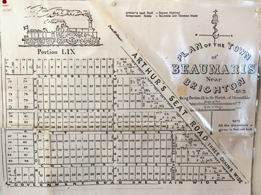
... John, Holloway Josiah, whorral charles, arthur’s seat road, nepean highway, morabbin district roads board, sandringham, mordialloc, mentone...John, Holloway Josiah, whorral charles, arthur’s seat road, nepean highway, morabbin district roads board, sandringham, mordialloc, mentone A Photocopy of the Plan of Beaumaris 1853 A3 Document, photocopy of Plan of Beaumaris 1853 CMHS member ...Beaumaris includes two early estates in the parish of Moorabbin developed by Josiah Holloway from 1852. Named Beaumaris Town and Beaumaris Estate (after the pastoral run in the area and ultimately after Beaumaris in Wales), the lots comprising them were marketed by Mr Holloway's suggesting that the railway was imminent and a canal would be built. The township developed slowly, a Post Office opened on 1 March 1868, but was replaced next month by Gipsy Village office (now Sandringham) In 1862 Beaumaris was one of the early settler communities within the boundaries of the Moorabbin District Roads Board , the region’s first local government authority. Beaumaris is a suburb in Melbourne, Victoria, Australia, 19 km south-east from Melbourne's central business district. .Since the Amalgamation of Councils 1994 the local government area is the City of Bayside which includes Brighton. A Photocopy of the Plan of Beaumaris 1853 A3moorabbin, county of bourke, brighton, beaumaris, pioneers, early settlers. market gardeners, cheltenham, king. john, holloway josiah, whorral charles, arthur’s seat road, nepean highway, morabbin district roads board, sandringham, mordialloc, mentone -
 City of Moorabbin Historical Society (Operating the Box Cottage Museum)
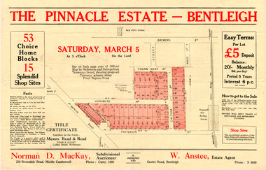
Flyer - Pinnacle Estate, Benteligh, 1927
... ...Pt. Nepean Road (now Nepean Highway)...Example of the progress of the Municipality of Moorabbin Patterson Road Pt. Nepean Road (now Nepean Highway) Vunabere Ave Galtum Ave Tovan-Akas Ave Patterson Bentleigh Auction Real Estate The Pinnacle Estate, Bentleigh - 53 Home sites & 15 Shop Sites - Auction Saturday March 5, 1927 - Norman D. ...The train line from the city to Frankston was electrified in 1922 which intensified the sale in the municipality of Moorabbin, particularly land which was in the vicinity of the railway stations.Example of the progress of the Municipality of MoorabbinAdvertising flyer for auction of real estate sales - plan of building blocks for saleThe Pinnacle Estate, Bentleigh - 53 Home sites & 15 Shop Sites - Auction Saturday March 5, 1927 - Norman D. MacKay and W. Ansteepatterson road, pt. nepean road (now nepean highway), vunabere ave, galtum ave, tovan-akas ave, patterson, bentleigh, auction, real estate -
City of Moorabbin Historical Society (Operating the Box Cottage Museum)
Booklet - Church of St Matthew Cheltenham Souvenir Diamond Jubilee (of current building) 1867 - 1927, 1927
... Road...Nepean Highway...St Matthew's Church of England was erected in Cheltenham beside the Nepean Highway near Charman Road. The early settlers established a tennis club, cricket team and social groups....St Matthew's Church of England Cheltenham was erected in 1867 and was integral to the spiritual well being and social life of the early settlers. st. matthew's church of england cheltenham anglican church early settlers parish of moorabbin city of moorabbin county of bourke shire of moorabbin were j.b. market gardeners Cheltenham Charman Road Nepean Highway Souvenir booklet of text and pictures produced for the Diamond Jubilee for the St Matthew's Church of England, Cheltenham - 18 pages Booklet Church of St Matthew Cheltenham Souvenir Diamond Jubilee (of current building) 1867 - 1927 ...St Matthew's celebrated it Silver Jubilee in September 1927 with Church Services and social gatherings, a concert, a social and a dance. St Matthew's Church of England was erected in Cheltenham beside the Nepean Highway near Charman Road. The early settlers established a tennis club, cricket team and social groups.St Matthew's Church of England Cheltenham was erected in 1867 and was integral to the spiritual well being and social life of the early settlers.Souvenir booklet of text and pictures produced for the Diamond Jubilee for the St Matthew's Church of England, Cheltenham - 18 pagesst. matthew's church of england cheltenham, anglican church, early settlers, parish of moorabbin, city of moorabbin, county of bourke, shire of moorabbin, were j.b., market gardeners, cheltenham, charman road, nepean highway -
City of Moorabbin Historical Society (Operating the Box Cottage Museum)
Booklet - Eightieth Celebration of the Patronal Festival - St Matthew's Church Cheltenham - commemoration of the Dedication 1867-1947, 1947
... Road...Nepean Highway...St Matthew's Church of England was erected in Cheltenham beside the Nepean Highway near Charman Road. The early settlers established a tennis club, cricket team and social groups....St Matthew's Church of England Cheltenham was erected in 1867 and was integral to the spiritual well being and social life of the early settlers. st. matthew's church of england cheltenham anglican church early settlers parish of moorabbin city of moorabbin county of bourke shire of moorabbin were j.b. market gardeners Cheltenham Charman Road Nepean Highway Booklet on the history of St Matthew's Church, Cheltenham Booklet Eightieth Celebration of the Patronal Festival - St Matthew's Church Cheltenham - commemoration of the Dedication 1867-1947 ...St Matthew's Church of England was erected in Cheltenham beside the Nepean Highway near Charman Road. The early settlers established a tennis club, cricket team and social groups.St Matthew's Church of England Cheltenham was erected in 1867 and was integral to the spiritual well being and social life of the early settlers.Booklet on the history of St Matthew's Church, Cheltenhamst. matthew's church of england cheltenham, anglican church, early settlers, parish of moorabbin, city of moorabbin, county of bourke, shire of moorabbin, were j.b., market gardeners, cheltenham, charman road, nepean highway -
City of Moorabbin Historical Society (Operating the Box Cottage Museum)
Book - Pioneers of Faith - St Matthew's Cheltenham 1867 - 1992, by Sue Polites, 1992
... Road...Nepean Highway...St Matthew's Church of England was erected in Cheltenham beside the Nepean Highway near Charman Road. The early settlers established a tennis club, cricket team and social groups....St Matthew's Church of England Cheltenham was erected in 1867 and was integral to the spiritual well being and social life of the early settlers. st. matthew's church of england cheltenham anglican church early settlers parish of moorabbin city of moorabbin county of bourke shire of moorabbin market gardeners Cheltenham Charman Road Nepean Highway Book about the history of St Matthew's Church, Cheltenham from 1867 to 1992. ...St Matthew's Church of England was erected in Cheltenham beside the Nepean Highway near Charman Road. The early settlers established a tennis club, cricket team and social groups.St Matthew's Church of England Cheltenham was erected in 1867 and was integral to the spiritual well being and social life of the early settlers.Book about the history of St Matthew's Church, Cheltenham from 1867 to 1992. The book contains photos.st. matthew's church of england cheltenham, anglican church, early settlers, parish of moorabbin, city of moorabbin, county of bourke, shire of moorabbin, market gardeners, cheltenham, charman road, nepean highway -
City of Moorabbin Historical Society (Operating the Box Cottage Museum)
Booklet - A History of the Cheltenham Methodist Church, Charman Road 1854 - 1954, by Dr. K. A. Stephenson, 1954
... Road...Nepean Highway...Cheltenham Methodist Church was integral to the spiritual well being and social life of the early settlers. early settlers parish of moorabbin city of moorabbin county of bourke shire of moorabbin market gardeners Cheltenham Charman Road Nepean Highway methodist church religion A booklet with 24 pages containing text and pictures by Dr. ...Cheltenham Methodist Church, history of the Methodist Congregation in Cheltenham and the building of their churches.Cheltenham Methodist Church was integral to the spiritual well being and social life of the early settlers.A booklet with 24 pages containing text and picturesearly settlers, parish of moorabbin, city of moorabbin, county of bourke, shire of moorabbin, market gardeners, cheltenham, charman road, nepean highway, methodist church, religion -
 Bayside Gallery - Bayside City Council Art & Heritage Collection
Photograph, Department of Crown Lands and Survey, Victoria, Brighton, Brighton East and Bentleigh, c. 1965-71
... Road...nepean highway...The significant landmark featured is Dendy Park, on the corner of Dendy Street and Nepean Highway. The main roads shown include Centre Road at the top, Nepean Highway diagonally across the photograph and South Road at the bottom....Brighton Department of Crown Lands and Survey Aerial photograph Bayside Port Phillip Bay Map cartographic material Bentleigh Brighton East Dendy Park Dendy Street Centre Road nepean highway South Road Football Black and white photograph. ...The Department of Crown Lands and Survey (1857-1983) was responsible for the administration of survey and mapping and the sale, occupation and management of crown land throughout its existence. This aerial photograph shows parts of Brighton, Brighton East and Bentleigh and was taken circa 1965-71.brighton, department of crown lands and survey, aerial photograph, bayside, port phillip bay, map, cartographic material, bentleigh, brighton east, dendy park, dendy street, centre road, nepean highway, south road, football -
 Bayside Gallery - Bayside City Council Art & Heritage Collection
Photograph, Department of Crown Lands and Survey, Victoria, Brighton, Brighton East and Bentleigh, c. 1965-71
... Road...nepean highway...The main roads shown include Centre Road at the top, Hampton Street on the left, a section of Nepean Highway diagonally across the right and South Road at the bottom....Brighton Department of Crown Lands and Survey Aerial photograph Bayside Port Phillip Bay Map cartographic material Brighton East Dendy Park Dendy Street Centre Road nepean highway South Road Brighton Golf Course Golf Black and white photograph. ...The Department of Crown Lands and Survey (1857-1983) was responsible for the administration of survey and mapping and the sale, occupation and management of crown land throughout its existence. This aerial photograph shows parts of Brighton and Brighton East and was taken circa 1965-71.brighton, department of crown lands and survey, aerial photograph, bayside, port phillip bay, map, cartographic material, brighton east, dendy park, dendy street, centre road, nepean highway, south road, brighton golf course, golf -
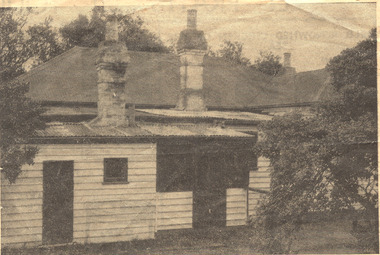 Chelsea & District Historical Society Inc
Photograph - Captain Lonsdale's Cottage, At Carrum
... Nepean Highway...Point Nepean Road...Alexander and put up as a beach house in Point Nepean Road (Nepean Highway). In 1959, the cottage was removed from Carrum and was recovered by the National Trust....Alexander and put up as a beach house in Point Nepean Road (Nepean Highway). In 1959, the cottage was removed from Carrum and was recovered by the National Trust. ...The cottage was built for Captain William Lonsdale (1799-1864), the first Police Magistrate of Melbourne. The cottage was built by the Royal Engineers in Sydney and flat packed to Melbourne in 1837, erected at Jolimont. In 1891 the cottage had to be removed to make way for the Jolimont Railway. It was bought by A. M. Alexander and put up as a beach house in Point Nepean Road (Nepean Highway). In 1959, the cottage was removed from Carrum and was recovered by the National Trust.Newspaper cutting, picture of Captain Lonsdale's Cottage, when it was situated in Point Nepean Road, Carrumcottage, beach house, nepean highway, point nepean road, captain lonsdale, carrum -
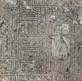
 City of Kingston
Photograph - Black and white, Aerial photograph Highett, 26 March 1956
... Aerial photograph Highett - Highett Reserve, Sandpits, Gasworks, Nepean Highway, Chesterville Road, Wickham Road....City of Kingston Parkdale Library 96 Parkers Road, Parkdale Parkdale Part of broad aerial photographic survey of the area. Aerial photograph Highett - Highett Reserve, Sandpits, Gasworks, Nepean Highway, Chesterville Road, Wickham Road. ...Part of broad aerial photographic survey of the area. Aerial photograph Highett - Highett Reserve, Sandpits, Gasworks, Nepean Highway, Chesterville Road, Wickham Road.The photograph shows the development of the city of Highett, suburban expansion and industrialisationsquare black and white photographic print on paper, with thick black border; printed text on bottom indicating date and other reference codeshighett, city of moorabbin, aerial photograph, suburbs, highett gas works, recreation, infrastructure -
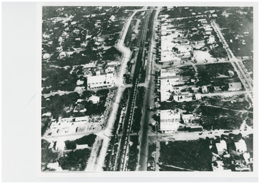 Chelsea & District Historical Society Inc
Photograph - Aerial Photo of Chelsea, c 1923
... Road...The Strand...Bath Street...Fox Theatre...Masons Theatre...Chelsea Railway Station...Thames Promenade...Nepean Highway...Street in photo are Station Street, Chelsea Road, Nepean Highway, Thames Promenade, Bath Street and The Strand. ...Street in photo are Station Street, Chelsea Road, Nepean Highway, Thames Promenade, Bath Street and The Strand. ...Points of interest in the photo are Fox Theatre in Station Street and Masons Theatre on the corner of Chelsea Road and Station Street; Chelsea Railway Station with a goods train going past. Street in photo are Station Street, Chelsea Road, Nepean Highway, Thames Promenade, Bath Street and The Strand. Black and white aerial photo of Chelsea. chelsea, aerial photo, station street, chelsea road, the strand, bath street, fox theatre, masons theatre, chelsea railway station, thames promenade, nepean highway