Showing 57 items matching " park rangers"
-
 Sunshine and District Historical Society Incorporated
Administrative record - City of Sunshine - Commissioner Mr Alexander "Alex" George Gillon Collection 1976 - 1982 - Memo from the City Engineer to Director of Parks & Recreation - Park Rangers and security inspections engineering depot and tip, City of Sunshine, 8/06/1978
... City of Sunshine - Commissioner Mr Alexander "Alex" George Gillon Collection 1976 - 1982 - Memo from the City Engineer to Director of Parks & Recreation - Park Rangers and security inspections engineering depot and tip...Park Rangers and secutiry inspections engineering depot and tip...City of Sunshine Alexander "Alex" George Gillon Park Rangers and secutiry inspections engineering depot and tip Paper Report Administrative record City of Sunshine - Commissioner Mr Alexander "Alex" George Gillon Collection 1976 - 1982 - Memo from the City Engineer to Director of Parks & Recreation - Park Rangers and security inspections engineering depot and tip City of Sunshine ...Park Rangers and secutiry inspections engineering depot and tip city of sunshine, alexander "alex" george gillon -
 Musculoskeletal Health Australia (now held by the Glen Eira Historical Society)
Photograph - Group photo, 19/03/2002
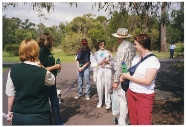
... ... park rangers...Guided by two Parks Victoria rangers, the group tried out a few walking paths consisting of varying levels of difficulty. ...COL photo of a small group of people of varying ages standing on a flat concrete path at a park, with two park rangers. Several people in the group are holding up a branded green plastic water bottle. ...Guided by two Parks Victoria rangers, the group tried out a few walking paths consisting of varying levels of difficulty. ...On Tuesday the 19th of March 2002, a small group of people of varying ages took part in assessing the level of difficulty of some walking paths at Jells Park in Wheeler's Hill. Their assessments would inform the development of a guide of graded walks as part of the Healthy Parks, Healthy People program. Guided by two Parks Victoria rangers, the group tried out a few walking paths consisting of varying levels of difficulty. Aterwards, they enjoyed a light lunch.COL photo of a small group of people of varying ages standing on a flat concrete path at a park, with two park rangers. Several people in the group are holding up a branded green plastic water bottle. One person has a dog on a leash.arthritis foundation of victoria, afv, healthy parks healthy people, graded walks trial, graded walks guide, jells park, walking paths, accessible walks, assessment, survey, park rangers, water bottle, dog, leash, wheelers hill, 2002 -
 Ballarat Heritage Services
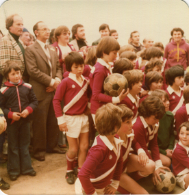
Photograph - Colour photograph, Opening of the Soccer Pavilion in Kew, 1980, 1980
... In 1981 the South Melbourne United club moved away from Middle Park to Kew, becoming Kew Park Rangers, eventually merging with Moreland at the end of 1985 to form Moreland Park Rangers....A number of soccer players of the Kew Park Rangers Soccer Club and men at the opening of the soccer pavilion. ...Ballarat Heritage Services PO Box 2209 Bakery Hill Post Office goldfields In 1981 the South Melbourne United club moved away from Middle Park to Kew, becoming Kew Park Rangers, eventually merging with Moreland at the end of 1985 to form Moreland Park Rangers. city of kew stranbroke park alan hutchinson john hogan gervasoni jack gervasoni rupert hamer A number of soccer players of the Kew Park Rangers Soccer Club and men at the opening of the soccer pavilion. ...In 1981 the South Melbourne United club moved away from Middle Park to Kew, becoming Kew Park Rangers, eventually merging with Moreland at the end of 1985 to form Moreland Park Rangers.A number of soccer players of the Kew Park Rangers Soccer Club and men at the opening of the soccer pavilion. city of kew, stranbroke park, alan hutchinson, john hogan gervasoni, jack gervasoni, rupert hamer -
 Musculoskeletal Health Australia (now held by the Glen Eira Historical Society)
Photograph - Group photo, 19/03/2002
... ... park rangers...Guided by two Parks Victoria rangers, the group tried out a few walking paths consisting of varying levels of difficulty. ...Guided by two Parks Victoria rangers, the group tried out a few walking paths consisting of varying levels of difficulty. ...On Tuesday the 19th of March 2002, a small group of people of varying ages took part in assessing the level of difficulty of some walking paths at Jells Park in Wheeler's Hill. Their assessments would inform the development of a guide of graded walks as part of the Healthy Parks, Healthy People program. Guided by two Parks Victoria rangers, the group tried out a few walking paths consisting of varying levels of difficulty. Aterwards, they enjoyed a light lunch.COL photo of a small group of people of varying ages posing for a photo along a flat concrete path at a park. Several people in the group are holding up a branded green plastic water bottle. One person has a dog on a leash (partially obcured).arthritis foundation of victoria, afv, healthy parks healthy people, graded walks trial, graded walks guide, jells park, walking paths, accessible walks, assessment, survey, park rangers, water bottle, wheelers hill, 2002 -
 Sunbury Family History and Heritage Society Inc.
Photograph, School Camp, 1988
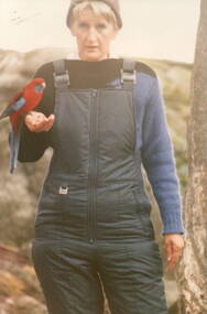
... A non-digital coloured photograph of a park ranger with a crimson rosella perched on her arm....School Camps Beechworth Crimson Rosellas Bulla Primary School MIckleham Primary SChool A non-digital coloured photograph of a park ranger with a crimson rosella perched on her arm. ...The ranger was helping the students from Bulla and MIckleham Primary Schools how to encourage the birds, that they were studying, to perch on their arms.The children were attending a school camp at Beechworth and one of their activities was to become acquainted with the native birds in the area.A non-digital coloured photograph of a park ranger with a crimson rosella perched on her arm.school camps, beechworth, crimson rosellas, bulla primary school, mickleham primary school -
 Ballarat Heritage Services
Photograph - Colour photograph, 1978
... In 1981 the South Melbourne United club moved away from Middle Park to Kew, becoming Kew Park Rangers, eventually merging with Moreland at the end of 1985 to form Moreland Park Rangers....Ballarat Heritage Services PO Box 2209 Bakery Hill Post Office goldfields In 1981 the South Melbourne United club moved away from Middle Park to Kew, becoming Kew Park Rangers, eventually merging with Moreland at the end of 1985 to form Moreland Park Rangers. city of kew john hogan gervasoni jack gervasoni kathleen gervasoni dorothy Benyei lazlo Benyei Left to right: Dorothy Benyei, Lazlo Benyei, Kathleen Gervasoni, Cr Jack Gervasoni in a City of Kew Town Hall. ...In 1981 the South Melbourne United club moved away from Middle Park to Kew, becoming Kew Park Rangers, eventually merging with Moreland at the end of 1985 to form Moreland Park Rangers.Left to right: Dorothy Benyei, Lazlo Benyei, Kathleen Gervasoni, Cr Jack Gervasoni in a City of Kew Town Hall.city of kew, john hogan gervasoni, jack gervasoni, kathleen gervasoni, dorothy benyei, lazlo benyei -
Whitehorse Historical Society Inc.
Document, Tiffany's Natural Order, 2005
... Article on ex-park ranger and agricultural journalist Carrie Tiffany. ...Article on ex-park ranger and agricultural journalist Carrie Tiffany. ...Article on ex-park ranger and agricultural journalist Carrie Tiffany.Article on ex-park ranger and agricultural journalist Carrie Tiffany. Her first novel 'Everyman's rules for scientific living' is set on the Better Farming Train in 1930s Victoria. Photo of Tiffany outside the barn at Schwerkolt Cottage & Museum Complex.Article on ex-park ranger and agricultural journalist Carrie Tiffany.better farming train, schwerkolt cottage & museum complex, tiffany, carrie -
 Sunbury Family History and Heritage Society Inc.
Photograph, Gellibrand Hill, 1987
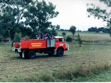
... The children from Bulla Primary School were taken for a ride around Gellibrand Hill on the back of a truck used by the park rangers at Gellibrand Hill near Bulla. The rangers were responsible for maintaining the bushland in the park and the students were at the park doing some tree planting....Sunbury Global Learning Centre Macedon Street Sunbury melbourne The children from Bulla Primary School were taken for a ride around Gellibrand Hill on the back of a truck used by the park rangers at Gellibrand Hill near Bulla. The rangers were responsible for maintaining the bushland in the park and the students were at the park doing some tree planting. ...The children from Bulla Primary School were taken for a ride around Gellibrand Hill on the back of a truck used by the park rangers at Gellibrand Hill near Bulla. The rangers were responsible for maintaining the bushland in the park and the students were at the park doing some tree planting.The excursion was included in then children's science and environmental studies.A non-digital photograph of a group of children in the back of a red conservation and environment truck in a bushland park.tree planting, gellibrand hill, bulla primary school, conservation -
 Sunbury Family History and Heritage Society Inc.
Photograph, Gellibrand Hill, 1987
... The students from Bulla Primary School were enjoying a tree-planting excursion at Gellibrand Hill and while they were taken for a ride around the park by the park ranger, the entire group were caught in a sudden shower of rain and had to take shelter under a large tarpaulin....Sunbury Global Learning Centre Macedon Street Sunbury melbourne The students from Bulla Primary School were enjoying a tree-planting excursion at Gellibrand Hill and while they were taken for a ride around the park by the park ranger, the entire group were caught in a sudden shower of rain and had to take shelter under a large tarpaulin. ...The students from Bulla Primary School were enjoying a tree-planting excursion at Gellibrand Hill and while they were taken for a ride around the park by the park ranger, the entire group were caught in a sudden shower of rain and had to take shelter under a large tarpaulin.A non-digital coloured photograph of children huddled under a large waterproof sheet to shelter from a sudden shower of rain with the truck which they were all on is parked a short distance from them.gellibrand hill, school excursions, bulla primary school -
 Sunbury Family History and Heritage Society Inc.
Photograph, Science excursion, 31st March 1996
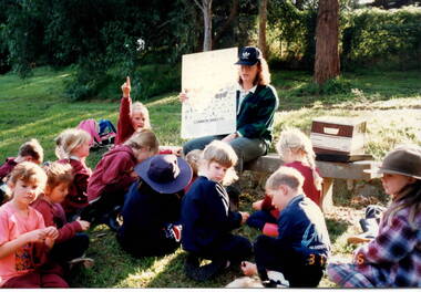
... They were studying the number and types of insects that could be found in the plants and water in the area. The park ranger then asked them to identify any insects on the chart that they found. ...They were studying the number and types of insects that could be found in the plants and water in the area. The park ranger then asked them to identify any insects on the chart that they found. ...The students from Bulla Primary School were taken on a nature excursion to a nearby nature park as part of their scientific and environmental studies. They were studying the number and types of insects that could be found in the plants and water in the area. The park ranger then asked them to identify any insects on the chart that they found. Nature and environmental studies give the students of the importance of caring for the environment and are included in their science work.A non-digital coloured photograph of a group of children sitting on the ground in front of a teacher who is holding up a chart featuring common insects. One child has her hand up while others are looking down onto the grass.bulla, bulla primary school, nature studies, school excursion -
 Sunbury Family History and Heritage Society Inc.
Photograph, Gellibrand Hill, 1987
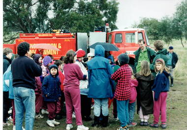
... After the ride a park ranger spoke to the group about the park and its importance in the local area....After the ride a park ranger spoke to the group about the park and its importance in the local area. ...The students from Bulla Primary School were taken on an excursion to Gellibrand Hill, a native parkland near Bulla. They did tree-planting and were taken for a ride around the park in the conservation and environment truck. After the ride a park ranger spoke to the group about the park and its importance in the local area.The excursion was included as part of the students science and environmental studies.A non-digital photograph of a group of children gathered around a red truck controlled by the Conservation and Environment personnel while a man explains to the children the importance of the vehicle. They are in a semi-bushland area. gellibrand hill, tree planting, bulla primary school, school excursions -
 Halls Gap & Grampians Historical Society
Photograph - B/W, Oct-86
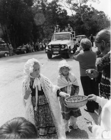
... A Toyota land cruiser with people dressed in what appears to be park ranger or scout uniforms standing in the tray is driving down the road and an old car can be seen behind that. ...A Toyota land cruiser with people dressed in what appears to be park ranger or scout uniforms standing in the tray is driving down the road and an old car can be seen behind that. ...This is part of a parade held on the main street of Halls Gap in conjunction with the 150th anniversary of Major Mitchell's visit to the area. The photo shows two young girls wearing flower patterned dresses, frilly hats and shawls standing on the edge of a road. The front girl is offering flowers in a straw basket to people lining the street. A Toyota land cruiser with people dressed in what appears to be park ranger or scout uniforms standing in the tray is driving down the road and an old car can be seen behind that. People and cars line the far side of the road and trees can be seen behind them.events, parades -
 Parks Victoria - Mount Buffalo Chalet
Cutlery
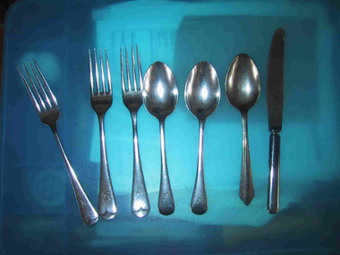
... These pieces of cutlery were found by a Parks Victoria ranger in a hollow log after the 2003 bushfires. ...Parks Victoria - Mount Buffalo Chalet Mount Buffalo Road Mount Buffalo National Park Mt Buffalo high-country These pieces of cutlery were found by a Parks Victoria ranger in a hollow log after the 2003 bushfires. ...These pieces of cutlery were found by a Parks Victoria ranger in a hollow log after the 2003 bushfires. It is possible these items were hidden for Chalet guests for picnics when they went out horseriding . There is reference to this practice in the "Mt Buffalo Story" 'Holidaymakers planning all day treks to distant features on the Plateau - Mount Macloed, the Great Wall of China of the Sarcophagus - collecteda packed lunch and anorange." (Pg 88. the Mount Buffalo Story)Listed in Draft Inventory of Significant Collection items. Appendix A.3.Tableware. (Pg 166 Historica).Three stainless steel forks with Victorian Railways insignia. Three stainless steel spoons, two with Victorian Railways insiginia. One stainless steel knife with Victorian Railways insiginia. (knife is burnt)On the two forks,"ALLBRITE STAINLESS STEEL" & "VR" On the two spoons,"ALLBRITE STAINLESS STEEL / VR" On burnt knife,"ALLBRITE FIRTH C....LY STAINLESS, VR" -
 Musculoskeletal Health Australia (now held by the Glen Eira Historical Society)
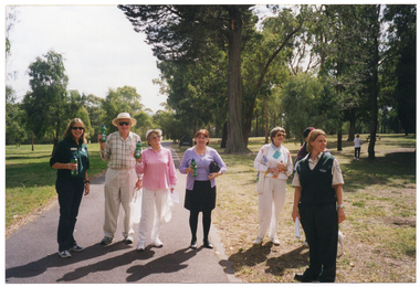
Photograph - Objects, 19/03/2002
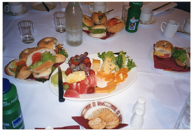
... Guided by two Parks Victoria rangers, the group tried out a few walking paths consisting of varying levels of difficulty. ...Guided by two Parks Victoria rangers, the group tried out a few walking paths consisting of varying levels of difficulty. ...On Tuesday the 19th of March 2002, a small group of people of varying ages took part in assessing the level of difficulty of some walking paths at Jells Park in Wheeler's Hill. Their assessments would inform the development of a guide of graded walks as part of the Healthy Parks, Healthy People program. Guided by two Parks Victoria rangers, the group tried out a few walking paths consisting of varying levels of difficulty. Aterwards, they enjoyed a light lunch.COL photo of various items of food. set up on a table covered with a white tablecloth. The food consists of salad rolls, a fruit and cheese platter, and a small plate of crackers. Also on the table is a glass bottle of water, two 'Healthy Parks Healthy People' branded green plastic water bottles, some glasses and various pieces of white crockery (cups and saucers, a small white milk jug, and a set of salt and pepper shakers).arthritis foundation of victoria, afv, healthy parks healthy people, graded walks trial, lunch, salad rolls, fruit platter, crackers, water bottle, 2002 -
 Conservation Volunteers
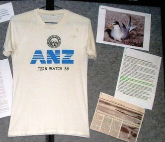
Tern Watch ANZ Bank promotional T shirt 1988 For five summers from 1987 to 1992 ATCV volunteers were landed on Rigby Island in Victoria’s Gippsland Lakes to “baby-sit” Little Terns, 1988
... Volunteers paid their own way to and from Bairnsdale railway station. Park Ranger and former ATCV employee Robert Brouwers with Helen Schneider (UK naturalist) and Tim Cox ‘maroon’ Tern Watch volunteers at Rigby Island in the Gippsland Lakes Vic > ...Volunteers paid their own way to and from Bairnsdale railway station. Park Ranger and former ATCV employee Robert Brouwers with Helen Schneider (UK naturalist) and Tim Cox ‘maroon’ Tern Watch volunteers at Rigby Island in the Gippsland Lakes Vic > In 2010 the status of the Little Tern populations in Australia was assessed under the ECBP Act and the determination was that, while the Gippsland Lakes population will continue to benefit from conservation action, they are no longer a threatened species. ...For five summers from 1987 to 1992 ATCV volunteers were landed on Rigby Island in Victoria’s Gippsland Lakes to “baby-sit” Little Terns (Sterna Albifrons) which breed in Asia and visit Australia in the Northern winter. By the mid 1980s the visiting population had dwindled dangerously due to predation and its very slow rate of reproduction. Conservation volunteers patrolled from dawn to dusk on a rotating 4 hour shift, educating visitors why they should stay away from the birds, and kept watch for pests. Terry Peacock’s logistics were heroic In support of the volunteers’ vigil: a boat, bunks, tents, tools, and a kitchen were bussed from Bendigo to Lakes Entrance. There were no outside funds at first, and only sale of promotional T-shirts together with small grants from the ANZ Bank and from Yellow Pages kept things going. Volunteers paid their own way to and from Bairnsdale railway station. Park Ranger and former ATCV employee Robert Brouwers with Helen Schneider (UK naturalist) and Tim Cox ‘maroon’ Tern Watch volunteers at Rigby Island in the Gippsland Lakes Vic > In 2010 the status of the Little Tern populations in Australia was assessed under the ECBP Act and the determination was that, while the Gippsland Lakes population will continue to benefit from conservation action, they are no longer a threatened species. White T shirt with ANZ in large blue letters with Tern Watch 1988 belowtern watch, atcv -
 Bayside Gallery - Bayside City Council Art & Heritage Collection
Photograph - sepia photograph, City of Brighton Mayor, Councillors and Officers - Peace & City Year - August 1919, 1919
... ...park ranger...Top row, L to R: T. Vincent, Park Ranger; J.N. Clark, Overseer; F. Blackham, Press; R.J. ...Top row, L to R: T. Vincent, Park Ranger; J.N. Clark, Overseer; F. Blackham, Press; R.J. ...brighton, council, mayor, councillors, officers, brighton town hall, t. vincent, park ranger, j.n. clark, overseer, f. blackham, press, r.j. lawrence, bank manager, a. vogt, assistant, j. clementson, inspector, l.w.p baker, assistant town clerk, g.w. woodward, hallkeeper, g. marsh, curator, a.f. magill c.e., city engineer, w. turner, cr. w.e. briggs, dr w.c. mcclelland, health officer, cr c.h.j. pickett, c.h. livesey, rate collector, cr j.a. grant, cr. j.w. satchwell, cr p.a. oakley, j. ritson, librarian, cr c.a. hack, cr j. richards, cr h.e. hall, cr t. wilson, j.h. taylor, town clerk, cr. w.p. francis, cr j.b. grout j.p., cr h.e. pullman, g.h. jefferson, solicitor, miss d.m. grout, typist, d. thomas, office boy, peace and city year -
 Musculoskeletal Health Australia (now held by the Glen Eira Historical Society)
Photograph - Objects, 19/03/2002
... Guided by two Parks Victoria rangers, the group tried out a few walking paths consisting of varying levels of difficulty. ...Guided by two Parks Victoria rangers, the group tried out a few walking paths consisting of varying levels of difficulty. ...On Tuesday the 19th of March 2002, a small group of people of varying ages took part in assessing the level of difficulty of some walks at Jells Park in Wheeler's Hill. Their assessments would inform the development of a guide of graded walks as part of the Healthy Parks, Healthy People program. Guided by two Parks Victoria rangers, the group tried out a few walking paths consisting of varying levels of difficulty. Aterwards, they enjoyed a light lunch. This photo depicts some Healthy Parks, Healthy People promotional water bottles, some branded bottles of water, some graded walks guide surveys, and a map on a table.COL photo of various items on a table covered with a white tablecloth. There are several 'Healthy Parks Healthy People' branded green plastic water bottles, some clear plastic water bottles, a can of Aeroguard mosquito spray, a bottle of sunscreen (partially obscured), a pen, some survey forms, and a printed flyer showing a map.arthritis foundation of victoria, afv, healthy parks healthy people, graded walks trial, graded walks guide, jells park, walking paths, accessible walks, assessment, survey, water bottle, wheelers hill, 2002 -
 Musculoskeletal Health Australia (now held by the Glen Eira Historical Society)
Photograph - Group photo, 19/03/2002
... Guided by two Parks Victoria rangers, the group tried out a few walking paths consisting of varying levels of difficulty. ...Guided by two Parks Victoria rangers, the group tried out a few walking paths consisting of varying levels of difficulty. ...On Tuesday the 19th of March 2002, a small group of people of varying ages took part in assessing the level of difficulty of some walking paths at Jells Park in Wheeler's Hill. Their assessments would inform the development of a guide of graded walks as part of the Healthy Parks, Healthy People program. Guided by two Parks Victoria rangers, the group tried out a few walking paths consisting of varying levels of difficulty. Aterwards, they enjoyed a light lunch. In this photo, the group poses for a photo. Front row, L to R: Max Atkins, Alix Atkins, Val Sakys, Barbara Kean, Robert Kean, Allan Stewart, Ruth Stewart. Back row, L to R: Kathy McCormack, Nicole Riley, Tim Bryar.COL photo of a group of people of varying ages posing for a group photo under a shelter, behind some wooden benches. In the background, there are several trees covered in green foliage.[Handwritten in black ink directly onto the photo, in the top right corner] 5 [circled]. [On a MOVE branded sticky note, handwritten in black ink - archivist's notes] UPDATE HEALTHY PARKS HEALTHY PEOPLE WALK JELLS PARK UPDATE WINTER 2002 (p. 3) Back L to R: Kathy McCormack, Nicole Riley, Tim Bryar, Front L to R: Max Atkins, Alix Atkins, Val Sakys, Barbara Kean, Robert Kean, Allan Stewart, Ruth Stewartarthritis foundation of victoria, afv, healthy parks healthy people, graded walks trial, graded walks guide, jells park, walking paths, accessible walks, assessment, survey, max atkins, alix atkins, val sakys, barbara kean, robert kean, allan stewart, ruth stewart, kathy mccormack, nicole riley, tim bryar, water bottle, wheelers hill, 2002 -
 Eltham District Historical Society Inc
Photograph - Digital Photograph, Alan King, St Andrews Anglican Church, St Andrews, 30 January 2008
... In 1928 he became Kinglake National Park’s first park ranger. Robert’s daughter Elizabeth, taught needlework at Queenstown State School, and later ran the post office in Kinglake....In 1928 he became Kinglake National Park’s first park ranger. Robert’s daughter Elizabeth, taught needlework at Queenstown State School, and later ran the post office in Kinglake. ...Built c.1868, St Andrew’s Anglican Church is Nillumbik Shire’s oldest timber church and is historically, socially, and spiritually significant to the Shire of Nillumbik. The church is historically significant because it may have given its name 'St Andrews' to the town (another suggestion is that the name came from the local hotel), it is also historically significant as one of only four buildings that remain from the Caledonian goldfields era of Queenstown (now St Andrews) and one of only a handful of buildings that survived the 1960s bushfires. The church is historically, socially, and spiritually significant because it has played an important part in community life for more than 150 years; a proposal to move the church in 1984 met with strenuous opposition. Much of the fires on Black Saturday 2009 were the north of the town. The town itself remained intact - as did this heritage building. Covered under Heritage Overlay, Nillumbik Planning Scheme. National Trust of Australia (Victoria) Local significance Published: Nillumbik Now and Then / Marguerite Marshall 2008; photographs Alan King with Marguerite Marshall.; p69 The St Andrews Anglican Church and former St Andrews Primary School, are two reminders of the district’s early days, when it was founded on gold. St Andrews, then called Queenstown, was the earliest goldfield in the Caledonia Diggings.1 It was the Upper Diamond Gold Mining and Administrative Centre, with 3000 miners. Queenstown was also the seat of the Court of Petty Sessions. The church and school then stood close to European and Chinese stores, three hotels, a brewery and a quartz mill.2 In 1861, Queenstown was officially proclaimed a township. From 1865, the name Queenstown was interchangeable with St Andrews, until 1952, when the town was officially named St Andrews. As gold declined from the early 1880s, Queenstown changed dramatically into a settlement of small farms. St Andrew’s Anglican Church, built in 1868, is the Shire’s oldest timber church and possibly gave its name to the township.3 The small timber church was opened on November 1, 1869, by the Dean of Melbourne. Anniversary tea meetings helped raise funds, and in 1889, a three-bedroom parsonage was built alongside. In 1910, the vicar, the Rev Selwyn Chase (and friend of the Scouting Movement’s founder, Baden Powell), established the 1st Queenstown Scout Troop, only two years after Scouting began in Australia. The church was important to the lives of many local residents who were baptised, married and had funeral services there. But by the 1950s the population had decreased and so did the weekly attendances. Around the mid-1960s the church closed, then fell into disrepair. So in the mid 1980s it was sold to the Education Department and was under threat of relocation or demolition. However this caused such opposition from locals,4 that instead, the Anglican church leased it as part of the Panton Hill parish5 and it was reconsecrated in 1987. Queenstown’s first school was held in a tent after transferring from Andersons Creek, Warrandyte.6 From 1858 a church school, Caledonia Diggings, stood west of the main road, a quarter of a mile (0.4km) before Buttermans Track. In 1882 the school was moved from a leased building, owned by headmaster Robert Harris, into a larger building on the corner of the School and the Heidelberg-Kinglake Roads. It had been moved from Smiths Gully and included a teacher’s three-roomed residence.7 In 1887 the school was replaced by the Queenstown State School No 128, although it was also called Caledonia Diggings until 1891. In 1956 it was renamed St Andrews. Still standing, this building is now used as the St Andrews Community Centre and the residence is leased for private use. The original timber-lined room remains alongside the extensions, and is distinctive with its high ceiling and tall small-paned windows. In 1984 a new school was built 500 metres west of the old school. Many residents have contributed much to St Andrews but one family that has done so for several generations is the Harris family. Robert Harris was an active member of the St Andrew’s Anglican Church, and worked hard at improving the town’s amenities until his death in 1887. He was a signatory to the successful 1863 petition to the Chief Commissioner of Police, against the proposed removal of the Court of Petty Sessions and police station at the Caledonia Diggings. The police station stayed in the town until 1917. Harris was Head Teacher of Queenstown State School from 1864 to 1874, then of the Smiths Gully school until it closed in 1882, and he continued teaching at Panton Hill until his death. His son, Robert Charles Harris, was editor and printer of the local newspaper, The Evelyn Observer, from 1873 until 1915. Robert’s son, William Shelley Harris, served in the Boer War and in World War One. In 1928 he became Kinglake National Park’s first park ranger. Robert’s daughter Elizabeth, taught needlework at Queenstown State School, and later ran the post office in Kinglake.This collection of almost 130 photos about places and people within the Shire of Nillumbik, an urban and rural municipality in Melbourne's north, contributes to an understanding of the history of the Shire. Published in 2008 immediately prior to the Black Saturday bushfires of February 7, 2009, it documents sites that were impacted, and in some cases destroyed by the fires. It includes photographs taken especially for the publication, creating a unique time capsule representing the Shire in the early 21st century. It remains the most recent comprehenesive publication devoted to the Shire's history connecting local residents to the past. nillumbik now and then (marshall-king) collection, st andrews, st andrews anglican church -
Marysville & District Historical Society
THE TRIANGLE NEWS-VOL 38 NO 11-APRIL 1 2011
... park...black saturday fires...parks victoria...chief ranger...Marysville & District Historical Society 39 Darwin Street Marysville yarra-valley-and-the-dandenong-ranges marysville victoria australia marsyville & district chamber of commerce black spur inn late night shopping at marysville central sugarloaf saddle rebuilt cindy mcleish cathedral range state park black saturday fires parks victoria chief ranger andrew markwick advertisements buxton primary school cartwheels creative arts wellbeing program marysville construction update darwin street reconstruction vbrra gallipoli park THE TRIANGLE NEWS-VOL 38 NO 11-APRIL 1 2011 ...marysville, victoria, australia, marsyville & district chamber of commerce, black spur inn, late night shopping at marysville central, sugarloaf saddle rebuilt, cindy mcleish, cathedral range state park, black saturday fires, parks victoria, chief ranger andrew markwick, advertisements, buxton primary school, cartwheels creative arts wellbeing program, marysville construction update, darwin street reconstruction, vbrra, gallipoli park -
 Federation University Historical Collection
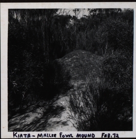
Photograph, Mallee Fowl Mounds, Little Desert
... A visit in 1972 to the Little Desert National Park by a group from Murtoa headed by ranger K Hateley to observe mallee fowls' mounds....Barker Library (top floor) Mount Helen goldfields A visit in 1972 to the Little Desert National Park by a group from Murtoa headed by ranger K Hateley to observe mallee fowls' mounds. ...A visit in 1972 to the Little Desert National Park by a group from Murtoa headed by ranger K Hateley to observe mallee fowls' mounds.Black and white photograph of a mallee fowl mound at Kiata..1 Front ; Kiata - Mallee Fowl mound Feb. 72 Verso: Little Desert .2 Front: Mallee Fowl incubator mound - Little Desert verso: Little Desert 1972 .3 Practise Mound Mallee Fowl 72 Verso: Little Desert Feb 1972 .4 Verso: Visited Mallee Hen Nest: Jack Watson, Herbert Smith, Lance Yung, H Hately - Ranger Kiata .5 Rev. H Smith K Hatelley Kiata L.D. Verso:Mallee Fowl Mounds Little Desert Feb 1972 Agfa -4.2.72 .6 Dad Lance Bert Smith K Hateley Verso: John R Watson Lance Yung (brother -in-law of John (Jack)) Bert Smith, (uncle of Lance ) Feb1972 Little Desertmallee fowls, mallee fowls mounds, mallee fowl incubator mounds, k hateley, john r watson, lance yung, herbert smith, bert smith, jack watson -
 Eltham District Historical Society Inc
Photograph, Fay Bridge, Book launch of Laughing Waters Road by Jane Woollard at Montsalvat, Eltham, 30 January 2016
... The dedication page is to our very own Ranger Campbell Beardsell OAM of Parks Vic who taught Jane to be “passionate about the environment of this special place” (p260). ...The dedication page is to our very own Ranger Campbell Beardsell OAM of Parks Vic who taught Jane to be “passionate about the environment of this special place” (p260). ...Laughing Waters Road , the book was launched at Montsalvat in Eltham. On Saturday, January 30, 2016, Nillumbik Council launched this book. The weather was cool; just as well, considering over 500 people attended this very pleasant event where food and drink were plentiful. The Australian Government and Nillumbik Shire Council funded the book and it was designed by Wayne Rankin of North Warrandyte. The dedication page is to our very own Ranger Campbell Beardsell OAM of Parks Vic who taught Jane to be “passionate about the environment of this special place” (p260). FOWSP members Val Polley, Linda Rogan and Ken Crook contributed to the content and photos. David Wandin, Wurundjeri Elder, gave a Welcome to Country and officially launched the book after the Mayor of Nillumbik, Cr Hattam, made introductions. Jane Woollard followed with a brief outline of how she came to write the book (her very first) and read out loud the last paragraph which focuses on reconciliation and shared culture. Jane declared in her preface that the book “has been formed by attending to the connection between rivulets of memories, creeks of hearsay, rivers of tales, the meanders of local legend and the deep, still pools of the archive.” Very poetic! - Lynda Gilbert Newsletter; Friends of Warrandyte State Park March 2016, Volume 34 Number 2 Laughing Waters Road , the book was launched at Montsalvat in Eltham ON SATURDAY 30 JANUARY Nillumbik Council launched this book. The weather was cool; just as well, considering over 500 people attended this very pleasant event where food and drink were plentiful. The Australian Government and Nillumbik Shire Council funded the book and it was designed by Wayne Rankin of North Warrandyte. The dedication page is to our very own Ranger Campbell Beardsell OAM of Parks Vic who taught Jane to be “passionate about the environment of this special place” (p260). FOWSP members Val Polley, Linda Rogan and Ken Crook contributed to the content and photos. David Wandin, Wurundjeri Elder, gave a Welcome to Country and officially launched the book after the Mayor of Nillumbik, Cr Hattam, made introductions. Jane Woollard followed with a brief outline of how she came to write the book (her very first) and read out loud the last paragraph which focuses on reconciliation and shared culture. Jane declared in her preface that the book “has been formed by attending to the connection between rivulets of memories, creeks of hearsay, rivers of tales, the meanders of local legend and the deep, still pools of the archive.” Very poetic! - Lynda Gilbert Newsletter; Friends of Warrandyte State Park March 2016, Volume 34 Number 2 https://fowsp.org.au/docs/News_2016/34_02_March.pdffay bridge collection, 2016-01-30, book launch, bronnie hattam, jane woollard, laughing waters road, montsalvat, sigmund jorgensen, harry gilham, maurice hurry -
Eltham District Historical Society Inc
Folder, Shelley Harris
... Folder of information on Shelley Harris, ranger, Kinglake National Park...Eltham District Historical Society Inc 728 Main Rd Eltham melbourne Shelley Harris Folder of information on Shelley Harris, ranger, Kinglake National Park Shelley Harris Folder ...Folder of information on Shelley Harris, ranger, Kinglake National Parkshelley harris -
Glen Eira Historical Society
Letter - GIRL GUIDES CAULFIELD
... Parks (two packs), with dates of formation and officers. Handwritten list (one page, undated) of Carnegie Girl Guides companies (3 companies) with dates of formation and officers Handwritten list (one page, undated) of Elsternwick Girl Guides Companies (one existing company, 2 previous companies), with officers. Handwritten list (undated), of Caulfield Division, Girl Guides’ Companies (6 Companies), with list of officers. Handwritten list (undated) of Girl Guides’ Ranger...Parks (two packs), with dates of formation and officers. Handwritten list (one page, undated) of Carnegie Girl Guides companies (3 companies) with dates of formation and officers Handwritten list (one page, undated) of Elsternwick Girl Guides Companies (one existing company, 2 previous companies), with officers. Handwritten list (undated), of Caulfield Division, Girl Guides’ Companies (6 Companies), with list of officers. Handwritten list (undated) of Girl Guides’ Ranger ...This file contains 20 items: A photocopy of a Girl Guides registration form, 1st Oakleigh Girl Guides, formed 6th August 1925, with names of captains, etc. A photocopy of a Girl Guides registration form Oakleigh and Murrumbeena district, 1st Oakleigh Trinity Company, 6th August 1925, with names of captains etc. A photocopy of a Girl Guides registration form, Oakleigh and Murrumbeena district, 1st Oakleigh Holy Trinity pack, formed 6th June 1929, with names of ‘Brown Owls’. This appears to be a component of the previous company. A photocopy of a Girl Guides registration form, 1st Murrumbeena Ranger company, formed 6th June 1933. A handwritten note states it was ‘disbanded April 1938.’ A photocopy of a Girl Guides registration form, 1st Murrumbeena Brownie Pack, formed 29th March 1930, with names of Brown Owls, etc. A photocopy from Matilda, December 1925, ‘Mrs. Maloprop’s Account of the Hamilton District Rally.’ Also lists of appointments as District Commissioners. A photocopy from Matilda March 1929, account of ‘Interstate Camp 1928/29.’ A photocopy from Matilda, September 1929, of ‘Imperial Headquarters Building Fund,’ etc. Handwritten letter (undated) from Meriel Hunt, Vic. Archivist to Mrs Ascup and (separately) Goula Astrup, ‘These are all the Rangers Units I could find.’ A photocopied cut-out (12 pages) of lists of Girl Guides Divisions and their officers in the South-Eastern Suburbs region. Includes 1945/46, 1947/48, 1948/49, 1949/50, 1950/51, 1951/52, 1952/53, 1953/54, 1955, 1956, 1957, 1958, 1959, 1960, 1961, 1962, 1963, 1964, 19654. Handwritten letter (2 pages, undated) from Irene to Goula concerning the Girl Guides’ records of companies formed after 1945. Handwritten list (two pages, undated) of Caulfield Girl Guides packs (7 packs) with dates of formation and officers. Date of formation range from 1957 to 1986. Handwritten list (one page, undated) of Carnegie Girl Guides Parks (two packs), with dates of formation and officers. Handwritten list (one page, undated) of Carnegie Girl Guides companies (3 companies) with dates of formation and officers Handwritten list (one page, undated) of Elsternwick Girl Guides Companies (one existing company, 2 previous companies), with officers. Handwritten list (undated), of Caulfield Division, Girl Guides’ Companies (6 Companies), with list of officers. Handwritten list (undated) of Girl Guides’ Ranger Units formed since 1945. Typewritten list (photocopy) of Queens Guides (by name if individual) in Caulfield, Murrumbeena,m Carnigie, and Elsternwick. Photocopied cut-outs (19 pages) of lists of Division and their officer bearers in South-Eastern Region of the Girl Guides. Includes 1967, 1968, 1969, 1970, 1971, 1972, 1973, 1974, 1975, 1976, 1977, 1978, 1979, 1980, 1981, 1982, 1983, 1984, 1985, 1986, 1987, 1988. 61st Annual Report Girl Guides Association of Victoria, 1986/87, 18 page printed booklet. 62nd Annual Report, Girl Guide of Victoria, 1987/88, 18 page printed booklet.girl guides, caulfield, murrumbeena, elsternwick, guide groups -
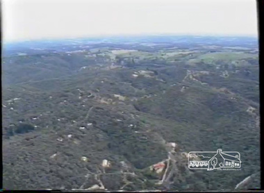
 Eltham District Historical Society Inc
Photograph - Digital Photograph, Alan King, Kinglake National Park, 27 March 2008
... Professor Laver was one of several people who gave land for the park, donating around 50 acres (20ha), including the Jehosaphat Gully.4 Laver chaired the park’s first Committee of Management, which raised money to employ a ranger and provide facilities, including tracks and roads for fire protection vehicles, toilets and shelters. ...Professor Laver was one of several people who gave land for the park, donating around 50 acres (20ha), including the Jehosaphat Gully.4 Laver chaired the park’s first Committee of Management, which raised money to employ a ranger and provide facilities, including tracks and roads for fire protection vehicles, toilets and shelters. ...Fern gullies around Jehosaphat Gully Covered under National Estate. Published: Nillumbik Now and Then / Marguerite Marshall 2008; photographs Alan King with Marguerite Marshall.; p125 The magnificent Kinglake National Park, fringing Nillumbik’s north, is the largest national park close to Melbourne. Thanks to the vision and hard work of a band of local people, the park was created from what was rapidly becoming degraded land. Seeing a threat to Kinglake’s indigenous flora and fauna, several prominent local people campaigned for a national park, which was established in 1928.1 Since then, the park has grown through donations and acquisitions of land, from around 13,800 acres of land (5585ha) to 22,360 hectares. The Sugarloaf and Everard Blocks – of almost 8000 hectares – stand in Nillumbik and the park extends into Mitchell and Murrundindi Shires and the City of Whittlesea. Mt Everard commemorates William Hugh Everard, State member for Evelyn when the park was established. Before 1928, European settlers had degraded the Kinglake area, which was named after the celebrated English author and lawyer, Alexander William Kinglake. Remains of gold shafts and diggings in the park are reminders of Kinglake’s first settlers, who hoped to strike it rich at the gold diggings. But like other gold fields in this shire, they proved not very lucrative and soon timber cutting replaced mining in importance. However, before long, the accessible timber supply ran out, so in the 1920s agriculture took over – particularly potatoes and berry fruits – which involved large-scale clearing.2 The park’s instigator was retired Melbourne University Professor of Music, William Laver.3 As chair of the Kinglake Progress Association he began negotiations to have crown lands on the southern scarp of the Great Dividing Range reserved as a national park. Even before the park was proclaimed, from 1927, KPA members cut tracks to the major scenic points. Professor Laver was one of several people who gave land for the park, donating around 50 acres (20ha), including the Jehosaphat Gully.4 Laver chaired the park’s first Committee of Management, which raised money to employ a ranger and provide facilities, including tracks and roads for fire protection vehicles, toilets and shelters. The committee charged fees for firewood collection, some grazing of livestock, and visitor entrance, and obtained small State Government and Eltham Shire grants. In 1957 the State Government provided revenue for national parks. Then, in 1975, the State Government took over the management and the Committee of Management became an advisory committee, which disbanded in 1978. Originally, the park covered crown land in the Shires of Eltham and Whittlesea; then Wombelano Falls in Yea and other areas were added. In 1970 the park extended into the Shires of Eltham, Healesville, Whittlesea and Yea.5 Bush fires have been an ongoing problem. In 1939 hundreds of eucalypts and acacias had to be sown around the Jehosaphat Gully to rejuvenate the forest. To manage bushfires, the Committee of Management, then the State Government, worked closely with the Forestry Commission, shire councils and local fire brigades. Early national parks focussed on recreation. But by the 1980s, conservation, education and scientific research became more important, playing a vital role in preserving representative samples of the natural environment. Each year many thousands of people use the park’s extensive network of walking tracks amongst the protected plant and animal life as well as camping, cycling and horse riding. The park, along the slopes of the Great Dividing Range, has lookouts revealing magnificent views of the Melbourne skyline, Port Phillip Bay, the Yarra Valley and the You Yangs. Vegetation in the Masons Falls area includes messmate forest, Austral grass-trees, ferns and Hazel Pomaderris. In spring, orchids, lilies, everlasting daisies, correas, grevillea and heath appear. Around Jehosaphat Gully are wet and dry forest, fern gullies and banksia. Animal life includes wallabies, kangaroos, koalas, echidnas, possums, gliders and bandicoots. Male lyrebirds can be heard mimicking in the Jehosaphat Gully, particularly in the Everard Block in winter.This collection of almost 130 photos about places and people within the Shire of Nillumbik, an urban and rural municipality in Melbourne's north, contributes to an understanding of the history of the Shire. Published in 2008 immediately prior to the Black Saturday bushfires of February 7, 2009, it documents sites that were impacted, and in some cases destroyed by the fires. It includes photographs taken especially for the publication, creating a unique time capsule representing the Shire in the early 21st century. It remains the most recent comprehenesive publication devoted to the Shire's history connecting local residents to the past. nillumbik now and then (marshall-king) collection, kinglake national park, jehosaphat gully -
 Bendigo Historical Society Inc.
Document - CORONATION CIVIC SERVICE, BENDIGO 1953, 1953
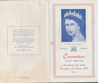
... Park, Bendigo, 2nd June 1953. $4 Page leaflet. Includes (on back page) a list of the organizations participating in the parade: Air Cadets, Australian Naval Cadet Corps, Boy Scouts and Cubs, Brownies, Girl Guides and Sea Rangers. ...Park, Bendigo, 2nd June 1953. $4 Page leaflet. Includes (on back page) a list of the organizations participating in the parade: Air Cadets, Australian Naval Cadet Corps, Boy Scouts and Cubs, Brownies, Girl Guides and Sea Rangers. ...Order of Service for Coronation Civic Service, Upper Rosalind Park, Bendigo, 2nd June 1953. $4 Page leaflet. Includes (on back page) a list of the organizations participating in the parade: Air Cadets, Australian Naval Cadet Corps, Boy Scouts and Cubs, Brownies, Girl Guides and Sea Rangers. Music provided by Band of the Northern Regiment, Bendigo Highland Pipe Band.place -
 Phillip Island and District Historical Society Inc.
Photograph, Kodak, 1940's
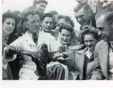
... Bert West was a ranger at the Nature Park on Phillip Island....Phillip Island and District Historical Society Inc. phillip-island-and-the-bass-coast Bert West was a ranger at the Nature Park on Phillip Island. bert west wildlife - shearwaters wildlife - mutton birds anne davie julie box Black & White photograph of Bert West holding a Mutton Bird - Shearwater - surrounded by a group of tourists. ...Bert West was a ranger at the Nature Park on Phillip Island.Black & White photograph of Bert West holding a Mutton Bird - Shearwater - surrounded by a group of tourists.bert west, wildlife - shearwaters, wildlife - mutton birds, anne davie, julie box -
 Eltham District Historical Society Inc
Film - Video (VHS), Phil Burke et al, Shire of Eltham Grants Commsission Submission (Series 69, Item 7), 1993
... ranger services...recreational facilities...research...richard allen...roads...rural areas...wingrove park...Video finishes with aerial views and parklands, streetscapes and rural areas. shire of eltham video recording shire of eltham archives eltham shire council eltham building permits cricket ground development applications eltham copper butterfly garbage collection graders green wedge lower plenty meals on wheels montmorency pat vaughan pauline toner reserve planning applications planning permits ranger services recreational facilities research richard allen roads rural areas wingrove park Victoria Grants Commission VHS Video cassette Converted to MP4 file format 00:07:39; 89MB Shire of Eltham Grants Commsission Submission (Series 69, Item 7) Film Video (VHS) Phil Burke Stuart Miller Roslyn Cohen Peter Mumme Gary Bartlett ...Shire of Eltham Archives: Series 69, Item 7 Opens with aerial views of the Shire, 85% of the shire covered by the Green wedge principal. Discusses the obligations required of the Shire to maintain the Green Wedge. The Shire covers over 27,000 hectares with a population in excess of 45,000 residents, more than 70% living in the southern 10% of the Shire in suburbs of Eltham, Montmorency, Lower Plenty and Research. 85% of the Shire in the more sparsely populated northern area which is covered by the Green Wedge. Council is committed to providing a parity of services to all residents such as garbage collection and maintenance of roads. Views of rubbish collection trucks in Montmorency. It is emphasised that the cost of these services in highly populated areas is relatively low whereas in the sparsely populated Green Wedge areas, considerable. There are hundreds of kilometres of roads throughout the Shire, many unmade and maintenance is high to check overhanging trees and erosion especially on the steep hills is expensive and disproportionate to servicing the population in the dense urban areas. Shows views of hilly gravel roads and graders at work maintaining them. Shows scenes of assessing planning applications in these rural areas which takes significantly more time as well as other services provided such as Meals on Wheels, building permits, Ranger services. Provision of recreational facilities in hilly areas requires the acquisition of expensive river flats (views of cricket ground surrounded by hills) and where not possible, costly earthmoving required. Also, views highlighting extensive tracks of natural habitat home to significant bird, animal and plant life. Shire emphasises its commitment highlighted by the Eltham Copper Butterfly which the Shire maintains small pockets of bushland to ensure its survival at significant expense (views of Pauline Toner Copper Butterfly Reserve.) Short interview with Pat Vaughan, Environmental Officer for the Shire discussing the Eltham Copper Butterfly who also mentions many other species in the Shire of high significance from bats to mammals to plants as well as the importance of the Green Wedge to Melbourne – the lungs of Melbourne - and ensuring the protection of very important habitat which requires a great deal of planning and management to look after. Views of Wingrove Park to emphasise this maintenance by machinery in some areas is too damaging and introduced species, etc must be removed by hand. Balancing the services and facilities expected by the community with the needs of the environment requires careful planning demands requires careful planning and the principals of the Green Wedge require constant attention in the face of growing need for housing. Director of Planning & Environment, Richard Allen advises there are approximately 1,300 planning permits and development applications each year ranging from simple subdivision, boundary realignments to further complicated non-urban developments for agricultural pursuits and the level of expertise required from architectural and engineering to land degradation, flora and fauna. Video finishes with aerial views and parklands, streetscapes and rural areas. VHS Video cassette Converted to MP4 file format 00:07:39; 89MBshire of eltham, video recording, shire of eltham archives, eltham shire council, eltham, building permits, cricket ground, development applications, eltham copper butterfly, garbage collection, graders, green wedge, lower plenty, meals on wheels, montmorency, pat vaughan, pauline toner reserve, planning applications, planning permits, ranger services, recreational facilities, research, richard allen, roads, rural areas, wingrove park, victoria grants commission -
 Eltham District Historical Society Inc
Postcard, L-R: Charlie Harris, Shelley Harris, Robert Harris, c. August 1915, 1915
... He embarked at Melbourne 26 August 1915 bound for Gallipoli and was killed in France, 19 July 1916. https://www.awm.gov.au/collection/P10238019 In the middle is his Uncle, Shelley Harris who later in life was the Ranger at Kinglake National Park 1936 'LIFE OF SERVICE', Advertiser (Hurstbridge, Vic. : 1922 - 1939), 19 June, p. 3. , viewed 03 Oct 2018, http://nla.gov.au/nla.news-article56842659 His brother Charlie Harris is on the far left. ...He embarked at Melbourne 26 August 1915 bound for Gallipoli and was killed in France, 19 July 1916. https://www.awm.gov.au/collection/P10238019 In the middle is his Uncle, Shelley Harris who later in life was the Ranger at Kinglake National Park 1936 'LIFE OF SERVICE', Advertiser (Hurstbridge, Vic. : 1922 - 1939), 19 June, p. 3. , viewed 03 Oct 2018, http://nla.gov.au/nla.news-article56842659 His brother Charlie Harris is on the far left. ..."Best wishes on the eve of his departure for the war from your old tennis mate, Private Robert Harris, No. 2073, 8th Reinforcements, 24th Battalion" Private Robert Jubilee Harris, printer of Kangaroo Ground, on the far right, was the son of Robert Charles Harris, printer and former editor of the Evelyn Observer which preceded the Advertiser. He embarked at Melbourne 26 August 1915 bound for Gallipoli and was killed in France, 19 July 1916. https://www.awm.gov.au/collection/P10238019 In the middle is his Uncle, Shelley Harris who later in life was the Ranger at Kinglake National Park 1936 'LIFE OF SERVICE', Advertiser (Hurstbridge, Vic. : 1922 - 1939), 19 June, p. 3. , viewed 03 Oct 2018, http://nla.gov.au/nla.news-article56842659 His brother Charlie Harris is on the far left. Their sister was Mrs H. Thomson.Digital file only - scanned by EDHS from item on loan aif, charles (charlie) thomas harris, charles thomas harris, charlie harris, first world war, honour roll, kangaroo ground, letters, lew howard collection, robert jubilee harris, shelley harris, william shelley harris, ww1 -
 Eltham District Historical Society Inc
Photograph, Kinglake National Park, Committee of Management
... park...prof. greenwood...prof. laver...ranger...It is significant in being the first community sourced collection representing the places and people of the Shire's first one hundred years. sepp shire of eltham pioneers photograph collection kinglake committee of management hewitt kinglake national park prof. greenwood prof. laver ranger shelley harris Digital image Kinglake National Park, Committee of Management. ...Left to Right: Prof. Laver, Prof. Greenwood, S. Harris (Hon. Ranger), Mr. Hewitt. Source: Dr. Edith J. Hewitt and Mrs. McMinn, KinglakeThis photo forms part of a collection of photographs gathered by the Shire of Eltham for their centenary project book,"Pioneers and Painters: 100 years of the Shire of Eltham" by Alan Marshall (1971). The collection of over 500 images is held in partnership between Eltham District Historical Society and Yarra Plenty Regional Library (Eltham Library) and is now formally known as the 'The Shire of Eltham Pioneers Photograph Collection.' It is significant in being the first community sourced collection representing the places and people of the Shire's first one hundred years.Digital imagesepp, shire of eltham pioneers photograph collection, kinglake, committee of management, hewitt, kinglake national park, prof. greenwood, prof. laver, ranger, shelley harris