Showing 40 items matching "air plotting"
-
 Moorabbin Air Museum
Booklet - Air Navigation, Air Navigation Plotting
... Air Navigation Plotting...Moorabbin Air Museum Moorabbin Airport 12 First Street Moorabbin melbourne Air Navigation Hanbook on air navigation plotting for prospective pilots & observers, circa 1943 Air Navigation Plotting Booklet Air Navigation ...Hanbook on air navigation plotting for prospective pilots & observers, circa 1943non-fictionHanbook on air navigation plotting for prospective pilots & observers, circa 1943 -
Moorabbin Air Museum
Book - Navigation, The Observer's Book on Dead Reckoning Navigation
... ...Air plotting...Moorabbin Air Museum Moorabbin Airport 12 First Street Moorabbin melbourne Navigation General remarks Position lines Air plotting Relative velocity Radius of action Overview of all forms of dead reckoning navigation, circa 1940 The Observer's Book on Dead Reckoning Navigation Book Navigation ...Overview of all forms of dead reckoning navigation, circa 1940non-fictionOverview of all forms of dead reckoning navigation, circa 1940general remarks, position lines, air plotting, relative velocity, radius of action -
 Bendigo Military Museum
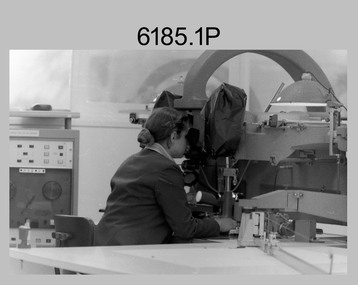
Photograph - Capturing Topographic Features with a Wild B8 – Army Survey Regiment, Fortuna, Bendigo, c1980
... This is a set of four photographs of a technician capturing topographic Features with a Wild B8 stereo plotter in Air Survey Squadron – Army Survey Regiment, Fortuna, Bendigo. 1980. ...This is a set of four photographs of a technician capturing topographic Features with a Wild B8 stereo plotter in Air Survey Squadron – Army Survey Regiment, Fortuna, Bendigo. 1980. ...These four photographs of SPR Santina (Argetto) Straube capturing topographic features – plotting with a Wild B8 stereo plotter were most likely taken in c1980. Introduced in 1966, the Wild B8 stereo plotter was used for plotting topographic detail and contours. These analogue machines were manually controlled by adjusting the control knobs for the orientation of the 3D image. The B8s used a nine-inch square photo image on a film or glass diapositive which allowed highly accurate extraction of map features. At first, plotting by B8 and B9 equipment was undertaken at the aerial photography scale of 1:80,000 in pencil onto a controlled plotting sheet. Sheets were then inked up and reduced photographically to the 1: 100,000 publication scale for scribe impression production. In these photos SPR Santina (Argetto) Straube was plotting with a pencil or ink pen mounted at the far end of the pantograph arm. The plotting procedure was upgraded to direct plotting in ink with photographic reduction to publication scale. In 1975 four B8s were upgraded with tri-axis locaters as part of the Input Sub-system to enable digital extraction to AUTOMAP 1’s topographic database. When AUTOMAP 2 was introduced in 1982 these B8s were upgraded, and additional machines added to expand the Army Survey Regiment’s digital capture capability. This is a set of four photographs of a technician capturing topographic Features with a Wild B8 stereo plotter in Air Survey Squadron – Army Survey Regiment, Fortuna, Bendigo. 1980. The photographs were on 35mm negative film and were scanned at 96 dpi. They are part of the Army Survey Regiment’s Collection. .1) to .4) Photo, black & white, c1980. SPR Santina (Argetto) Straube operating a Wild B8 stereo plotter..1P to .4P – no annotations.royal australian survey corps, rasvy, army survey regiment, army svy regt, fortuna, asr, air survey, photogrammetry -
 Bendigo Military Museum
Administrative record - Australian Survey Corps - Liaison Letters 1936 - 1939, 1st, 2nd, 3rd and 4th Military Districts, Australia, July 1936 - June 1939
... Carter Methods of plotting from air photographs. .... Editor, Canadian Surveyor -- The Australian Survey Corps Para 2. ...Carter Methods of plotting from air photographs. .... Editor, Canadian Surveyor -- The Australian Survey Corps Para 2. ...Liaison Letters details happenings within the various Sections of the Australian Survey Corps to inform all members of current information and practices. 9137.1 Liaison Letter No 1. 21 July 1937. Para 1. Object of Letter. See context section. Para 3. Progress of work. Incomplete, rest of Letter missing only 1 page. 9137.2 Liaison Letter No 2 Letter missing. 9137.3 Liaison Letter No 3. Jan 1937. Para 1. Our thanks are due to the following for articles contributed. .... W/O H. Rossiter. -- "Aerial Surveying". -- Article missing. .... W/O W. M. Sarll. -- "A day in the Draughting Office". -- Report on No 1 Field Sheet, Sale. -- Article missing. .... W/O H. A. Johnson. -- "Semigraphic methods of resection and intersection". -- Article missing. .... Capt. J.J. Raisbeck "Rapid production and reproduction of Military maps". Article missing. .... Lt. L. Fitzgerald. report "Survey Exercise at Sale". Article missing. .... W/O W. M. Sarll. report on No1. Field Sheet, Sale. Article missing. Para 3. Progress of work. .... "No1 Draughting Section". .... Printing. .... No1 Survey Section. .... No2 Survey Section. .... Pages 3 - 6 Missing. .... Article by W/O W. M. Sarll. "A day in the Draughting Office". Pages 7 - 10. 9137.4 Liaison Letter No 4. April 1937. Para 1. Our thanks are due to the following for articles contributed. .... Lieut. H. W. G. Clews. -- Notes on the non-ascertained Base problem. -- Article missing. .... W/O W. M. Sarll. -- Helpful hints on air photos. -- Article missing. .... Capt. T. H. B. Foott. .... & Capt. J.J. Raisbeck. -- A short history of the Military Survey of Australia. -- Article missing. .... W/O H. Rossiter. -- Notes on Aerial Surveying. -- Article missing. .... W/O H. A. Johnson. -- A type of Beacon. -- Article missing. Para 2. Progress of work. ..... No1 Draughting Section. ..... No1 Survey Section. ..... Pages missing. 9137.5 Liaison Letter No 5, July 1937. Para 1. Our thanks are due to the following for articles contributed .... Lt L. Fitzgerald -- A new section and its job. -- Article missing. .... WO G.R.L. Remington. .... & H. E. Eggeling. Azimuth of the Plane table. -- Article missing. .... W.O. B. M. Sarll. -- The Second Annual Smoke Night of the Members of the Aust.Survey Corps stationed in Victoria. .... Also included is a very interesting article on the United States Geological Survey by J. F. Staask, extracted from the Canadian Surveyor. February 1936. -- Article missing. Para 2. Progress of work. .... No1. Draughting Section. .... No 1 Topographical Section. No further articles till page 7. .... The Second Annual Smoke Night of the members of the Aust. Survey Corps. Stationed in Victoria. Pages 7 - 9. 9137.6 Liaison Letter No 6, September 1937. Para 1. Our thanks are due to the following for articles contributed .... Lt L. Fitzgerald. -- Geodetic Triangulation reconnaissance. Article missing. -- Article missing. .... Lt. R.F. Rule, M.M. -- A suggested Form for Field Book 3rd Order Traverses. -- Article missing. .... W/O. H. A. Johnson. -- A suggested Form for Quadrilateral Adjustments. -- Article missing. Para 2. Progress of work. .... No1. Draughting Section. .... No 1 Topographical Section. No further pages to letter 6. 9137.7 Liaison Letter No 7. January 1938. Para 1. Our thanks are due to the following for articles contributed. .... Major T. A. Vance. -- Report on the Survey of a Training Area in Tasmania. -- Article missing. .... W/O D. Macdonald. -- The naming of Trigonometrical Stations. -- Article missing. Para 2. Progress of work. .... No1 Draughting Section A.H.Q. .... No1 Topographical Section, 4 M.D. .... No2 Topographical Section 3 M.D. .... No3 Topographical Section 2 M.D. .... No4 Topographical Section A.H.Q. No further pages to letter 7. 9137.8 Liaison Letter No 8. April 1938. Para 1. Our thanks are due to the following for articles contributed .... Capt. H.P.G.Clews. -- A possible method of estimating Stereoscopic ability. -- Article missing. .... W/O. A.L.Smith. -- Hints to Topographers from a Draughtsman's point of view. .... W/O. W.W. Sarll. -- Seeing that which a Surveyor sees. Para 1.a. -- Relative to article on naming of trig stations which appeared in No7. This contribution has examples of naming. Para 1.d. Enlistment. -- George Gladstone Bolwell was enlisted as W/O.II. Draughtsman in the No. 1 Draughting Section A.H.Q. on the 26th April 1938. Mr. Bolwell was of the Victorian Lands Department. Para 1.e. Embarkation. -- Major T.A. Vance. O.C. Aust Survey Corps, embarked S.S. "Monterey". 28 Mar 1938 to undergo six months training in USA and Canada. Para 1.f. Promotions. -- To be Capt. (prov.) Lieut. H.P.G. Clews 9.11.1937. Para 1.g. Medals -- Award of Aust. Meritorious Service Medal -- W/O.H. Rossiter. .... Award of Aust. Medal for Long Service and Good Conduct -- W/O, A.L. Smith. Para 2. Progress of work. .... No.1 Draughting Section A.H.Q. .... No.1 Topographical Section, 4 M.D. .... No.2 Topographical Section 3 M.D. .... No.3 Topographical Section 2 M.D. .... No.4 Topographical Section A.H.Q. Article missing by Capt. H.P.G.Clews. -- A possible method of estimating Stereoscopic ability. Article by W/O. A.L.Smith. -- Hints to Topographers from a Draughtsman's point of view. Contains 3 pages. Article by W/O. W.W. Sarll. -- Seeing that which a Surveyor sees. Contains 3 pages. 9137.9 Liaison Letter No 9. July 1938. Para 1. Our thanks are due to the following for articles contributed .... Captain H.P.G.Clews -- Computation of log p and log v; also Abbreviated interpolation. .... W/O. G.R.L. Rimington. -- Light Weight Camping Gear. .... W/O. H.A. Johnson. -- The use of the Calculating Machine on Resections, etc,; also comments by O.C.No.4 Topographical Section on this article. Para 1.a. A.A.O. 104. Examination for Appointment to the Rank of Lieutenant. February - March,1938. .... W.O.I. A.L. Smith. .... W.O.I. W.M. Sarll. .... W/O. II. G.R.L. Rimington. .... W/O. II. A.F. Kurrle. .... W/O. II. H.A. Johnson. .... W/O. II. D. MacDonald. .... W/O. II. H.F.Eggeling. .... For Captain. .... Capt. (p) H.P.G. Clews. .... Lieut. L. FitzGerald. .... Lieut. R.K. Rule M.M. Para.1. b. A.A.O. 109. Allotment W/O. II. W.B. Relf to No.3 Topo Section 2 M.D., 5.4.38. Para.1. c. Gaz. No. 37 -- Promotions. -- To be Captain, Lieut. L FitzGerald. 5th July 1938. -- The provisional promotion of Captain H.P.G. Clews is confirmed. Para. 2. Progress of Work. .... No.1 Draughting Section A.H.Q. .... No.1 Topographical Section, 4 M.D. .... No.2 Topographical Section 3 M.D. .... No.3 Topographical Section 2 M.D. .... No.4 Topographical Section 2 M.D. 9137.10 Liaison Letter No 10. October 1938. Para 1. Our thanks are due to the following for articles contributed. .... Lieut. R.K. Rule M.M. -- Barometric levelling in Forest Areas. .... W/O. H.A. Roseblade -- Adjustment of principal points on master grid. .... W/O. II. A.F. Kurrle. -- The Hunter short base applied to photo control. .... W/O. W.B. Relf -- Reunion at Newcastle. .... The articles are all missing Para. 1. a. A.A.O. 184. Discharge -- W/O. II. G.G. Bolwell. 15th July 1938. Para. 1. b. A.A.O. 174-195, 31.8.38. Vacancy for Draughtsman. Para. 1. c. Obituary. -- Major John Lynch. 29th July 1938. Para. 2. Progress of Work. .... No.1 Draughting Section A.H.Q. .... No.1 Topographical Section, 4 M.D. .... No.2 Topographical Section 3 M.D. .... No.3 Topographical Section 2 M.D. .... No.4 Topographical Section A.H.Q. 9137.11 Liaison Letter No 11. January 1939. Para 1. Our thanks are due to the following for articles contributed. .... Major T.A. Vance. -- Training Abroad, Canada and U.S.A. .... Captain L. Fitzgerald -- Air Reconnaissance for 1st Order Triangulation. .... W/O C.E. Stewart. -- Reunion at Traralgon. Para 2. A.A.O. 301/38. .... a. Appointments. -- Royal Ormond Worcester, on enlistment in the Aust Permanent Military Forces is appointed W/O II. 30th November 1938. -- Thomas Micheal Connolly, on enlistment in the Aust Permanent Military Forces is appointed W/O II. 30th November 1938. .... b. Discharge. -- No. 3614 W/O II. G.R.L. Rimington. 30th November 1938. .... c. Awards of the Australian Military Medal for Long Service and Good Conduct (Military). -- No.1175, W/O I, E.T. Johnson. .... d. Return of Officers to Australia. -- Major T.A. Vance, having completed training in the United States of America, Canada and New Zealand, returned to Aust. on the S.S. "Awatea", disembarked Sydney on 3rd December 1938. .... e. Allotment. -- No.3689, W/O. II A.F. Kurrle, allotted to No. 4 Topographical Section, A.H.Q., 1 January 1939. Para. 2. Progress of Work. .... Cartographic Section, A.H.Q. .... Geodetic Section, A.H.Q. .... No.1 Survey Section, 4 M.D. .... No. 2 Survey Section, 3 M.D. .... No. 3 Survey Section, 2 M.D. 9137.12 Liaison Letter No 12. March 1939. Para 1. Our thanks are due to the following for articles contributed. .... W/O H.F. Eggeling -- Topographical Survey and Barometric Levelling. .... W/O G.T.P. Carter Methods of plotting from air photographs. .... Editor, Canadian Surveyor -- The Australian Survey Corps Para 2. A.A.O. 57 -- .... a. Promotion. -- No. 3577 S/Sgt G.T.P. Carter. appointed Topographer promoted to W/O II. 15th January 1939. .... b. Allotment -- The following are allotted to No. 3 Topographical Section 2 M.D. 1st February 1939. .... No, 171 W/O I B. Rossiter. .... No. 178 W/O. I V.W. Aldred. .... No. 150 W/O. I A.T. Smith. .... c. Transfer. -- No. 369 W.O. A.F.Kurrle. to No. 4 Topo Section A.H.Q. 1st January 1939. .... d. Promotions -- To be Major J.J. Raisbeck. and Lieut. W.M. Sarll as of 1st January 1939. Para. 3. Progress of Work. .... Cartographic Section, A.H.Q. .... No.4 Topographical Section, A.H.Q. .... No.2 Topographical Section, 3 M.D. .... No.3 Topographical Section, 2 M.D. .... Articles Missing -- W/O H.F. Eggeling -- Topographical Survey and Barometric Levelling. -- W/O G.T.P. Carter Methods of plotting from air photographs .... Article -- Editor, Extract from "The Canadian Surveyor" -- The Australian Survey Corps. 9137.13 Liaison Letter No 13. June 1939. Para 1. Our thanks are due to the following for articles contributed. .... Lieut. W.M. Sarll -- Meeting a crisis with maps and equipment; also comments by O.C. Cartographic Section. .... W/O H.F. Eggeling -- Design and description of an Epidiascope. -- Article missing. .... Editor, Melbourne Herald -- "They do a Vital Task". 6th July, 1939. .... Also enclosed is a Corps Seniority Roll. -- Article missing. Para 2. a. A.A.O. 118/39. -- Appointment to Lieutenant, February, March, 1939. .... 3572 W/O. I. H.C. Raisbeck. .... 3684 W/O. I.I. T.R. Westgarth. .... 3686 W/O. I.I. C.E.B. Stewart. .... 3702 W/O. I.I. C. S. Tyler. .... 4479 W/O. I.I. W.B. Relf. Para. 2. b. A.A.O. 127/39 -- Appointment to W/O. I.I. .... G. V. Brooke. 5.4.39. .... L. J. Lockwood. 5.4.39. .... J. P. Hanley. 17.4.39. .... W. J. Harrison. 24.4.39. .... J. K. C. Herridge. 1.5.39. Para 2. c Gaz. 26/39. Awards of the Aust. Medal for Long Service and Good Conduct Military. .... No. 1439 W/O. I. H. A. Roseblade. .... No. 1176 W/O. I. J. Cullen. Para. 3. Progress of Work. .... Cartographic Section, A.H.Q. .... Geodetic Section A.H.Q. .... No. 2 Survey Section, 3 M.D. .... No. 3 Survey Section, 2 M.D. .... Editor, Melbourne Herald -- "They do a Vital Task". 6th July, 1939. .... Lieut. W.M. Sarll -- Meeting a crisis with maps and equipment; also comments by O.C. Cartographic Section. 9137.1 Liaison Letter No 1. 21 July 1937. Para 1. Object of Letter. The object of these letters, which it is to be proposed quarterly, is to enable members of the Australian Survey Corps to stimulate interest in the progress of the work as a whole. It is also intended as a means to invite helpful criticism and suggestions for improvements in methods in any branch of the work. All members of the Corps are invited to contribute. Their suggestion should be forwarded to the O.C. section for transmission to O, C. Survey Corps and, if considered of sufficient merit, will be included in the next letter. It may often happen that a method, that may appear obvious and of little consequence to a member or Section using it, may not be followed by the others. In any case a discussion of detail in methods should be helpful to all.54 x A4 Photocopied pages of typed text. 9137.1 Liaison Letter No 1. 21 July 1937. 9137.2 Liaison Letter No 2 Letter missing. 9137.3 Liaison Letter No 3. Jan 1937. 9137.4 Liaison Letter No 4. April 1937. 9137.5 Liaison Letter No 5, July 1937. 9137.6 Liaison Letter No 6, September 1937. 9137.7 Liaison Letter No 7. January 1938. 9137.8 Liaison Letter No 8. April 1938. 9137.9 Liaison Letter No 9. July 1938. 9137.10 Liaison Letter No 10. October 1938. 9137.11 Liaison Letter No 11. January 1939. 9137.12 Liaison Letter No 12. March 1939. 9137.13 Liaison Letter No 13. June 1939. royal australian survey corps, army survey regiment, fortuna, rasvy, army svy regt, asr -
 Warrnambool and District Historical Society Inc.
Article, Newspaper S McDonald, 1940’s
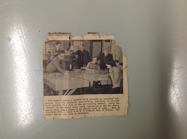
... Here the plotters are marking positions of aircraft with symbols on a map of the surrounding district while the Teller in the raised chair sends reports on to the Air Force, which thus has a check of all planes left to right Mrs. ...Air Observers Corps, Mrs. S Hamilton, Mrs. J Lees, F/O E F English Mrs. R Picton Mr. Ralph Barnes Miss S McDonald warrnambool The picture shows a control room manned by volunteer personnel. Here the plotters ...The Volunteers Air Observers was formed in 1941 with the aim of observing aircraft flying over Australia. There were over 24000 civilians volunteering their services and as the military threat to Australia subsided they took on roles as coast and weather watching. This photograph shows a group of local volunteers at their work. Mrs. S Hamilton, Mrs. J Lees, F/O E F English, Mrs. R Picton, Mr. Ralph Barnes and Miss S McDonaldA local item which relates to an organization which operated around Australia in the 1940’s. Small newspaper cutting with photograph with six people around a table. Text is underneath the photo. The back has an advertisement for Fletcher Jones clothingThe picture shows a control room manned by volunteer personnel. Here the plotters are marking positions of aircraft with symbols on a map of the surrounding district while the Teller in the raised chair sends reports on to the Air Force, which thus has a check of all planes left to right Mrs. S Hamilton, Mrs. J Lees, F/O E F English, Mrs. R Picton, Mr. Ralph Barnes and Miss S McDonald volunteer air observers corps,, volunteer air observers corps,, mrs. s hamilton,, mrs. j lees,, f/o e f english, mrs. r picton, mr. ralph barnes, miss s mcdonald warrnambool -
 Bendigo Military Museum
Photograph - Capturing Topographic Features with a Wild B8, AUTOMAP 2 Systems Operations – Army Survey Regiment, Fortuna, Bendigo, 1990
... This is a set of two photographs of Air Survey Squadron technicians - LCPL Peter Murphy and SPR Rachel (Stanford) Scott capturing topographic features with a Wild B8 stereo plotter with AUTOMAP 2 equipment at the Army Survey Regiment, Fortuna, Bendigo, c1990. ...This is a set of two photographs of Air Survey Squadron technicians capturing topographic features with a Wild B8 stereo plotter with AUTOMAP 2 equipment at the Army Survey Regiment at Fortuna, Bendigo, c1990. ...plotter. The history of the AUTOMAP 2 system is covered in more detail with additional historic photographs in pages 119, 137-142 and 180 of Valerie Lovejoy’s book 'Mapmakers of Fortuna – A history of the Army Survey Regiment’ ISBN 0-646-4: 2120-4. See items 6087.10P and 6223.23P for additional photographs of the AUTOMAP 2 system. Royal Australian Survey Corps RASvy Army Survey Regiment Army Svy Regt Fortuna ASR Photogrammetry .1P to .2P – no annotations This is a set of two photographs of Air ...This is a set of two photographs of Air Survey Squadron technicians - LCPL Peter Murphy and SPR Rachel (Stanford) Scott capturing topographic features with a Wild B8 stereo plotter with AUTOMAP 2 equipment at the Army Survey Regiment, Fortuna, Bendigo, c1990. Refer to item 6185.4P and 6204.8P for detailed information and additional photographs of the Wild B8 stereo plotter. The history of the AUTOMAP 2 system is covered in more detail with additional historic photographs in pages 119, 137-142 and 180 of Valerie Lovejoy’s book 'Mapmakers of Fortuna – A history of the Army Survey Regiment’ ISBN 0-646-4: 2120-4. See items 6087.10P and 6223.23P for additional photographs of the AUTOMAP 2 system.This is a set of two photographs of Air Survey Squadron technicians capturing topographic features with a Wild B8 stereo plotter with AUTOMAP 2 equipment at the Army Survey Regiment at Fortuna, Bendigo, c1990. The photographs are on 35mm negative film. They are part of the Army Survey Regiment’s Collection. The photographic negatives were scanned at 96 dpi. .1) - Photo, colour, 1990. LCPL Peter Murphy operating a Wild B8 stereo plotter. .2) - Photo, colour, 1990. SPR Rachel (Stanford) Scott operating a Wild B8 stereo plotter..1P to .2P – no annotationsroyal australian survey corps, rasvy, army survey regiment, army svy regt, fortuna, asr, photogrammetry -
 Bendigo Military Museum
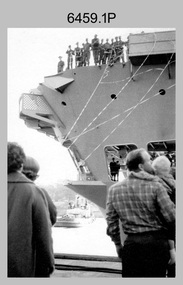
Photograph - A Section, 1st Topographic Survey Troop, Vung Tau, Vietnam, 1966
... air on the chartered Qantas 707B ‘City of Longreach'. A Section’s main tasks were to establish a Theatre Grid, map compilation and map revision; Engineer Survey Support in the camp and to the civil community; give assistance to the Cordon Search Missions by producing large scale plots from aerial photos with every house and fence etc plotted; and then reproduce these by silk screening usually, within a 24-hour period. ...air on the chartered Qantas 707B ‘City of Longreach'. A Section’s main tasks were to establish a Theatre Grid, map compilation and map revision; Engineer Survey Support in the camp and to the civil community; give assistance to the Cordon Search Missions by producing large scale plots from aerial photos with every house and fence etc plotted; and then reproduce these by silk screening usually, within a 24-hour period. ...This is a set of 12 photographs of A Section, 1st Topographic Survey Troop taken from the 25th of May to the 12th of June 1966 during their deployment to Vung Tau, Vietnam. Led by OC CAPT Bob Skitch, the ten personnel from A Section 1st Topo Svy Tp and six personnel from supporting units were the first contingent from the Royal Australian Survey Corps deployed to provide topographic support to the Australian Task Force in Vietnam. They arrived in Saigon, Vietnam on the 10th of June 1966 enroute to the Australian Reinforcement Unit (ARU) “back beach” camp in Vung Tau. The ten RA Svy technical personnel from 1st Topo Svy Tp deployed were: WO2 David Christie, SGT Stan Campbell, SGT Dave King, CPL Jim Roberts, CPL Dennis Duquemin, CPL Des Ceruti, SPR Derek Chambers, SPR Brian Firns, SPR Joe O’Connor and SPR Ron Smith. External personnel deployed were: WO2 Snow Rollston from Northern Command Field Survey Unit, T/CPL Peter Clarke – orderly room corporal, T/CPL Alan Carew – Technical Storeman, SPR Stan Johns – Map Storeman, SPR Boots Campbell – batman/driver and PTE BNF Brunning – cook. The ship featured in photos .1P and .2P was the aircraft carrier HMAS Sydney on its 4th voyage to Vietnam. On board were SGT Stan Campbell and SPR Brian Firns, tasked to manage A Section’s stores and equipment. The rest of A Section deployed to Vietnam by air on the chartered Qantas 707B ‘City of Longreach'. A Section’s main tasks were to establish a Theatre Grid, map compilation and map revision; Engineer Survey Support in the camp and to the civil community; give assistance to the Cordon Search Missions by producing large scale plots from aerial photos with every house and fence etc plotted; and then reproduce these by silk screening usually, within a 24-hour period. RA Svy’s support concluded with the withdrawal of Australian troops from Vietnam in 1972. More information on the A Section, 1st Topographic Survey Troop and the Army Survey Regiment’s supporting role is provided in pages 89 to 94 of Valerie Lovejoy’s book 'Mapmakers of Fortuna – A history of the Army Survey Regiment’ ISBN: 0-646-42120-4.This is a set of 12 photographs of A Section, 1st Topographic Survey Troop (1st Topo Svy Tp), taken from the 25th of May to the 12th of June 1966 during their deployment to Vung Tau, Vietnam. The black and white photographs were printed on photographic paper and are part of the Army Survey Regiment’s Collection. The photographs were scanned at 300 dpi. .1) &.2) - Photo, black & white, 1966. HMAS Sydney departing Woolloomooloo wharf en-route to Vietnam. .3) - Photo, black & white, 1966. A Section 1 Topo Svy Tp relaxing in a bar before deployment. OC CAPT Bob Skitch in centre of photo. .4) - Photo, black & white, 1966. Unidentified A Section 1 Topo Svy Tp personnel and troops from other units relaxing in a bar before deployment. .5) - Photo, black & white, 1966. A Section 1 Topo Svy Tp personnel arrival by bus at Saigon (Tan Son Nhut) Airport. OC CAPT Bob Skitch 4th from right. .6) - Photo, black & white, 1966. A Section 1 Topo Svy Tp personnel boarding the USAF Hercules aircraft enroute from Saigon (Tan Son Nhut) Airport to Vung Tau Airfield. OC CAPT Bob Skitch on left. .7) - Photo, black & white, 1966. A Section 1 Topo Svy Tp personnel and troops from other units boarding the USAF Hercules aircraft enroute from Saigon (Tan Son Nhut) Airport to Vung Tau Airfield. .8) & .9) - Photo, black & white, 1966. A Section 1 Topo Svy Tp personnel arrive at the Australian Reinforcement Unit (ARU) “back beach” camp. .10) - Photo, black & white, 1966. A Section 1 Topo Svy Tp personnel in oppressive conditions work on map products. .11) - Photo, black & white, 1966. Group photo of A Section 1 Topo Svy Tp. OC CAPT Bob Skitch on far right. .12) - Photo, black & white, 1966. Group photo of A Section 1 Topo Svy Tp. OC CAPT Bob Skitch 3rd from right.Annotated with the photo set - ‘ DET 1 Topo Svy Tp Vung Tau 25 May to 12 of Jun 66’royal australian survey corps, rasvy, army survey regiment, army svy regt, fortuna, asr, 1st topographical survey troop -
 Bendigo Military Museum
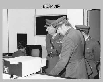
Photograph - Visit by the Chief of the General Staff to the Army Survey Regiment, Fortuna, Bendigo, 1979
... Air Survey Squadron. LTGEN General Sir Donald Dunstan AC, KBE, CB; and unidentified technician view 3D stereoscopic aerial photography on a Wild B8 stereo plotter. .6) - Photo, black and white, 1979. ...Air Survey Squadron. LTGEN General Sir Donald Dunstan AC, KBE, CB; and unidentified technician view 3D stereoscopic aerial photography on a Wild B8 stereo plotter. .6) - Photo, black and white, 1979. ...This is a set of 14 photographs of a visit to the Army Survey Regiment, Fortuna, Bendigo on the 5th of June 1979 by the Chief of the General Staff (CGS) Lieutenant General Sir Donald Dunstan AC, KBE, CB. He was accompanied by his wife. They were escorted through the production areas of the Army Survey Regiment by the CO LTCOL Bob Skitch. Lieutenant General Sir Donald Dunstan AC, KBE, CB was an esteemed Australian Army officer, who was CGS from 1977 to 1982. Upon retirement from the Army in 1982, he was appointed to the position of Governor of South Australia from 1982 to 1991. LTCOL Bob Skitch was the CO of the Army Svy Rgt from 1976 to 1980. Also featuring in these photos is MAJ Peter Eddy, who was the OC of Air Survey Squadron. He was later promoted to LTCOL and was CO of the Army Svy Rgt from 1981 to 1982. See item 6035.9P for photos of the CGS’s presentation of the Defence Force Service Medal to four recipients.This is a set of 14 photographs of a visit by the Chief of the General Staff to the Army Survey Regiment Fortuna, Bendigo on the 5th of June 1979. The photographs were printed on photographic paper and are part of the Army Survey Regiment’s Collection. They were scanned at 300 dpi. .1) - Photo, black and white, 1979. Tour of Air Survey Squadron. L to R: unidentified, LTGEN General Sir Donald Dunstan AC, KBE, CB; OC MAJ Peter Eddy, unidentified. .2) - Photo, black and white, 1979. Tour of Air Survey Squadron. LTGEN General Sir Donald Dunstan AC, KBE, CB; views 3D stereoscopic aerial photography on a Zeiss (Jena) Stecometer. OC MAJ Peter Eddy is on his right. .3) - Photo, black and white, 1979. Tour of Air Survey Squadron. L to R: unidentified, CO LTCOL Bob Skitch, OC MAJ Peter Eddy, LTGEN General Sir Donald Dunstan AC, KBE CB viewing an aerial photograph. WO1 Brian Mead and others are operating a Wild PUG4 point transfer device. .4) - Photo, black and white, 1979. Enlargement of photo .3). Tour of Air Survey Squadron. L to R: unidentified, CO LTCOL Bob Skitch, OC MAJ Peter Eddy, LTGEN General Sir Donald Dunstan AC, KBE CB viewing an aerial photograph. .5) - Photo, black and white, 1979. Tour of Air Survey Squadron. LTGEN General Sir Donald Dunstan AC, KBE, CB; and unidentified technician view 3D stereoscopic aerial photography on a Wild B8 stereo plotter. .6) - Photo, black and white, 1979. Tour of Air Survey Squadron. L to R: OC MAJ Peter Eddy LTGEN General Sir Donald Dunstan AC, KBE CB; CO LTCOL Bob Skitch, view the output of a verification plot on an AUTOMAP 1 Gerber 1442 drum plotter. .7) - Photo, black and white, 1979. Tour of Air Survey Squadron. L to R: CO LTCOL Bob Skitch, unidentified aide de camp officer, LTGEN General Sir Donald Dunstan AC, KBE CB; OC MAJ Peter Eddy discuss aero triangulation planning documents. CAPT Don Maskew in background. .8) - Photo, black and white, 1979. Tour of Cartographic Squadron. L to R: CPL Dennis Learmonth, acting OC CAPT Bob Roche, CAPT Eddy Schulze, LTGEN General Sir Donald Dunstan AC, KBE CB; SSGT John ‘JB’ Barrie discuss cartographic map compilation procedures .9) - Photo, black and white, 1979. Tour of Cartographic Squadron. L to R: Tech WO WO1 Roger Rix, acting OC CAPT Bob Roche, CAPT Eddy Schulze, unidentified visitor, Mrs Dunstan with examples of map products. .10) - Photo, black and white, 1979. Tour of Cartographic Squadron. L to R: CPL Terry Danger, CO LTCOL Bob Skitch, LTGEN General Sir Donald Dunstan AC, KBE CB; discuss terrain embossing (hill shading) procedures. .11) - Photo, black and white, 1979. Tour of Cartographic Squadron. L to R: CO LTCOL Bob Skitch, LTGEN General Sir Donald Dunstan AC, KBE CB; acting OC CAPT Bob Roche, SSGT Dick Manley, CAPT Don Maskew and CAPT Steve Cooper in background. SPR Cheryl Lofthouse is retouching blemishes on a map separation film negative. .12) - Photo, black and white, 1979. Tour of Lithographic Squadron. L to R: CAPT Stan Vote, unidentified aide de camp officer, CO LTCOL Bob Skitch, LTGEN General Sir Donald Dunstan AC, KBE CB; MAJ Sam Schwartz EXCH-US, LT John Harrison discuss bulk map printing processes with an Ultra-MAN-III Printing Press. .13) - Photo, black and white, 1979. Officers Mess L to R: LTGEN General Sir Donald Dunstan AC, KBE CB; with CO LTCOL Bob Skitch. .14) - Photo, black and white, 1979. Officers Mess L to R: MAJ Peter Eddy, LTGEN General Sir Donald Dunstan AC, KBE CB..1P to .14P – no annotationsroyal australian survey corps, rasvy, army survey regiment, army svy regt, fortuna, asr -
 Bendigo Military Museum
Photograph - Photogrammetric Equipment – Army Survey Regiment, Bendigo and School of Military Survey Bonegilla, c1960s to c1980s
... This is a set of 14 photographs of RA Svy technicians operating photogrammetric equipment in Air Survey Squadron, Army Survey Regiment, Fortuna, Bendigo; and the School of Military Survey Bonegilla c1960s to c1980s. The Wild B9 stereo plotter...Bendigo Military Museum 37 - 39 Pall Mall Bendigo goldfields This is a set of 14 photographs of RA Svy technicians operating photogrammetric equipment in Air Survey Squadron, Army Survey Regiment, Fortuna, Bendigo; and the School of Military Survey Bonegilla c1960s to c1980s. The Wild B9 stereo plotter ...This is a set of 14 photographs of RA Svy technicians operating photogrammetric equipment in Air Survey Squadron, Army Survey Regiment, Fortuna, Bendigo; and the School of Military Survey Bonegilla c1960s to c1980s. The Wild B9 stereo plotter were introduced in 1962 and the Wild B8 stereo plotter was introduced in 1966. The Wild B9 and B8 stereo plotters were used for plotting topographic detail and contours. These analogue machines were manually controlled by adjusting the control knobs for the orientation of the 3D image. The B9s used a four and a half square, and the B8s used a nine-inch square photo image on a film or glass diapositive which allowed highly accurate extraction of map features. At first, plotting with B8 and B9 stereo plotters was undertaken at the aerial photography scale of 1:80,000 in pencil onto a controlled plotting sheet. Sheets were then inked up and reduced photographically to the 1: 100,000 publication scale for scribe impression production. In the early days topographic detail and contours were plotted with a pencil or ink pen mounted at the far end of the pantograph arm. The plotting procedure was upgraded to direct plotting in ink with photographic reduction to publication scale. In 1975 four B8s were upgraded with tri-axis locaters as part of the Input Sub-system to enable digital extraction to AUTOMAP 1’s topographic database. When AUTOMAP 2 was introduced in 1982 these B8s were upgraded, and additional machines added to expand the Army Survey Regiment’s digital capture capability. There are several more photos catalogued in the Victorian Collections database of RA Svy personnel operating Wild B9 and B8 stereo plotters.Photogrammetric Equipment – Army Survey Regiment, Fortuna, Bendigo c.1981. . .7) – Unidentified technician operating Wild B8 stereo plotter in AUTOMAP 1 at ASR. .8) - Wild B8 stereo plotter in AUTOMAP 1 at ASR. Photogrammetric Equipment – Army Survey Regiment, Fortuna, Bendigo. c1981. .9) – ASR’s CPL Dave Cook in AUTOMAP 1 operating a Wild B8 stereo plotter. This is a set of 14 photographs of RA Svy technicians operating photogrammetric equipment at the Army Survey Regiment (ASR), Bendigo and the School of Military Survey (SMS) Bonegilla. c1960s to c1980s. The photographs are on 35mm colour slides and were scanned at 96 dpi. .1) - Photo, colour, c1964. Unidentified ASR technicians operating analogue Wild B9 stereo plotters. .2) - Photo, colour, c1974. ASR’s SPR Mick Minchin operating an analogue Wild B8 stereo plotter. .3) to .6) - Photo, colour, c1980. Photogrammetry Instructor SGT Neil ‘Ned’ Kelly at the SMS operating an analogue Wild B8 stereo plotter. .7) - Photo, colour, c1981. Unidentified technician operating Wild B8 stereo plotter in AUTOMAP 1 at ASR. .8) - Photo, colour, c1981. Wild B8 stereo plotter in AUTOMAP 1 at ASR. .9) to .14) - Photo, colour, c1981. ASR’s CPL Dave Cook in AUTOMAP 1 operating a Wild B8 stereo plotter..1P to .14P - Some of the equipment is annotated on the frame of the 35mm slides.royal australian survey corps, rasvy, army survey regiment, army svy regt, fortuna, asr, photogrammetry -
 Bendigo Military Museum
Photograph - Technical Tour of the Army Survey Regiment, 1963, c1965
... plotter featured in photo .2P and the M.A.N. Ultraman 3 Offset printing press probably featured in the background of photos .3P and .5P. Royal Australian Survey Corps RASvy Army Survey Regiment Army Svy Regt Fortuna ASR printing air survey .1 to .5 - annotated “Visit by General” This is a set of photographs of a visiting Australian Army General’s technical tour of the Army Survey Regiment, Bendigo. ...These photographs were most likely taken in 1963 and c1965 on two separate occasions of an Australian Army General’s visit to the Army Survey Regiment, Fortuna, Bendigo. As there are no annotations on the photos, the exact date and the names of the Generals are unknown. Some RASvy personnel are positively identified. The technical tour included the photogrammetric and printing areas of the Regiment. The newly introduced Wild B8 stereo plotter featured in photo .2P and the M.A.N. Ultraman 3 Offset printing press probably featured in the background of photos .3P and .5P.This is a set of photographs of a visiting Australian Army General’s technical tour of the Army Survey Regiment, Bendigo. The photographs were printed on photographic paper and are part of the Army Survey Regiment’s Collection. The photographs were scanned at 300 dpi. .1) - Photo, black & white, c1965. L to R: unidentified General, CAPT Carol Castor .2) - Photo, black & white, c1965. L to R: unidentified, unidentified General, Director Survey - COL Don Macdonald AM, CO – LTCOL Frank Buckland OBE. .3) - Photo, black & white, c1965. L to R: 2LT Dennis Puniard, unidentified, unidentified General, CAPT Reg Smith, MAJ Don Ridge, WO1 Aub Harvey .4) - Photo, black & white, c1965. L to R: CAPT Reg Smith, unidentified General. .5) - Photo, black & white, 1963. L to R: WO2 Ken Rich, MAJ GEN Taylor, MAJ Bill Howarth..1 to .5 - annotated “Visit by General”royal australian survey corps, rasvy, army survey regiment, army svy regt, fortuna, asr, printing, air survey -
 Bendigo Military Museum
Map - RASvy " Map Makers Exhibition 2025 "- Map display, RAN Hydrographic Office, 1972 - 1992
... PLOTTING CHART. NP 43-7 SOLOMON ISLANDS. MERCATOR PROJECTION. Used for the planning of RAAF flights. .6 RAAF AIR STAFF PLANNING CHART NS 137-1 DARWIN NORTH WEST. ...Current as at 30 Jun 92. .2 Extract of Navigational Plotting Chart " NP22-2 Tasmania " .3 Extract of Navigational Plotting Chart " NP 27 RAAF PLOTTING CHART AUSTRALIA - SOUTHEAST " .4 Extract of Navigational Plotting Chart " RAAF LONG RANGE PLOTTING CHART NP43-4 AUSTRALIA WESTERN " .5 Extract of Navigational Plotting Chart " RAAF LONG RANGE PLOTTING CHART NP43-7 SOLOMON ISLANDS " .6 Extract of Navigational Series " RAAF AIR STAFF PLANNING CHART NS 137-2 DARWIN NORTH WEST " .7 Extract of Navigational Series " RAAF AIR STAFF PLANNING CHART NS 137-1 DARWIN NORTH EAST " .8 Extract of Navigational Series " RAAF AIR STAFF PLANNING CHART NS 137-4 DARWIN SOUTH WEST " .9 Extract of Navigational Series " RAAF AIR STAFF PLANNING CHART NS 137-3 DARWIN SOUTH EAST " .10 Extract of Tactical Pilotage Chart " TPC R-13B " .11 Extract of Hydrographic Chart " PORT PHILLIP SOUTH and WEST CHANNELS " .12 Extract of Hydrographic Chart " GEELONG HARBOUR and APPROACHES " .13 Extract of En Route Chart " AUSTRALIA ERC HIGH " " H1 and H2 " ...PLOTTING CHART. NP 43-7 SOLOMON ISLANDS. MERCATOR PROJECTION. Used for the planning of RAAF flights. .6 RAAF AIR STAFF PLANNING CHART NS 137-1 DARWIN NORTH WEST. ...All of these Charts / Maps were used for the RSL Museum display " The Mapmakers " ( of RASvy. ) 10 Jun - 10 Aug 2025. .1 Catalogue of Tactical Pilotage Charts, 1:500 000 Scale. Digital Data Base available as at 30Jun 92. This catalogue page shows the extent of the Australian area of responsibility for aeronautical charting. .2 RAAF PLOTTING CHART. NP 22-2 (Navigational Plotting) Tasmania. MERCATOR PROJECTION. This series of charts were used for the training of RAAF Navigators. These charts were produced and printed at the Army Survey Regiment, Bendigo. .3 RAAF PLOTTING CHART AUSTRALIA - SOUTHEAST. NP 27 is Based on LAMBERT CONFORMAL CONIC PROJECTION. This series of charts was used by RAAF Navigators for the planning of RAAF flights. These charts were produced and printed at the Army Survey Regiment, Bendigo. .4 RAAF LONG RANGE PLOTTING CHART. NP 43-4 AUSTRALIA WESTERN. MERCATOR PROJECTION. This series of maps were used for the planning of RAAF flights. Of Particular note these charts were used to plot "Rhumb Lines or loxodromes" where a course crosses all Meridians (Lines of latitude and longitude) at the same angle. On Mercator projection charts Rhumb lines are conveniently shown as straight lines and are also lines of constant compass bearing. Rhumb lines are usually longer than the shortest distance between two points. The shortest distance between two points on the earth's surface is called a "Great Circle Route" which is a route on a circular path on the surface of the earth where the centre of that circle is also the centre of the earth. Great Circle Routes on a Mercator Projection are however curves and harder to plot. These charts were produced and printed at the Army Survey Regiment, Bendigo. .5 RAAF LONG RANGE PLOTTING CHART. NP 43-7 SOLOMON ISLANDS. MERCATOR PROJECTION. Used for the planning of RAAF flights. .6 RAAF AIR STAFF PLANNING CHART NS 137-1 DARWIN NORTH WEST. AZIMUTHAL EQUIDISTANT PROJECTION. This series of charts were used for planning by the staff. The whole chart was produced by joining the four quadrant maps together. The charts are based on a single point of tangency (in this case Darwin) and shows radius (distance) in nautical miles to and from that point. A series of charts were produced centred on each of the major airfields in Northern Australia. These charts were produced and printed at the Army Survey Regiment, Bendigo. .7 RAAF AIR STAFF PLANNING CHART NS 137-2 DARWIN NORTH EAST. AZIMUTHAL EQUIDISTANT PROJECTION. Used for the planning by the staff. The charts are based on a point of tangency and show radius in nautical miles. .8 RAAF AIR STAFF PLANNING CHART NS 137-4 DARWIN SOUTH WEST. AZIMUTHAL EQUIDISTANT PROJECTION. Used for the planning by the staff. The charts are based on a point of tangency and show radius in nautical miles. .9 RAAF AIR STAFF PLANNING CHART NS 137-3 DARWIN SOUTH EAST. AZIMUTHAL EQUIDISTANT PROJECTION. Used for the planning by the staff. The charts are based on a point of tangency and show radius in nautical miles. .10 TACTICAL PILOTAGE CHART. TPC R-13B. LAMBERT CONFORMAL PROJECTION. Used by pilots for flight planning and could be used in flight if necessary for visual navigation using major ground features shown on the chart. These charts also contained aeronautical information such as airfields, radio navigation beacons and obstructions. Contours and height information was shown in feet to be compatible with aircraft altimeters. Each graticule square also contained a Maximum Safe Elevation Figure (MEF) also in feet. Coverage of this series over Australia's area of interest were produced and printed at the Army Survey Regiment, Bendigo. .11 HYDROGRAPHIC CHART. AUS 158. PORT PHILLIP SOUTH and WEST CHANNELS. PROJECTION TRANSVERSE MERCATOR. Used by all people needing to navigate a vessel. Hydrographic charts were printed at the Army Survey Regiment, Bendigo. .12 HYDROGRAPHIC CHART. AUS 157. GEELONG HARBOUR and APPROACHES. PROJECTION TRANSVERSE MERCATOR. Used by all people needing to navigate a vessel. .13 EN ROUTE CHART. AUSTRALIA ERC HIGH. H1 and H2. LAMBERT CONFORMAL CONIC PROJECTION. This series of charts were regularly produced by the RAAF Aeronautical Information Service (AIS) and contained current aeronautical information for pilots. These charts were printed at the Army Survey Regiment, Bendigo..1 Tactical Pilotage Chart Series Catalogue. Current as at 30 Jun 92. .2 Extract of Navigational Plotting Chart " NP22-2 Tasmania " .3 Extract of Navigational Plotting Chart " NP 27 RAAF PLOTTING CHART AUSTRALIA - SOUTHEAST " .4 Extract of Navigational Plotting Chart " RAAF LONG RANGE PLOTTING CHART NP43-4 AUSTRALIA WESTERN " .5 Extract of Navigational Plotting Chart " RAAF LONG RANGE PLOTTING CHART NP43-7 SOLOMON ISLANDS " .6 Extract of Navigational Series " RAAF AIR STAFF PLANNING CHART NS 137-2 DARWIN NORTH WEST " .7 Extract of Navigational Series " RAAF AIR STAFF PLANNING CHART NS 137-1 DARWIN NORTH EAST " .8 Extract of Navigational Series " RAAF AIR STAFF PLANNING CHART NS 137-4 DARWIN SOUTH WEST " .9 Extract of Navigational Series " RAAF AIR STAFF PLANNING CHART NS 137-3 DARWIN SOUTH EAST " .10 Extract of Tactical Pilotage Chart " TPC R-13B " .11 Extract of Hydrographic Chart " PORT PHILLIP SOUTH and WEST CHANNELS " .12 Extract of Hydrographic Chart " GEELONG HARBOUR and APPROACHES " .13 Extract of En Route Chart " AUSTRALIA ERC HIGH " " H1 and H2 " royal australian survey corps, rasvy, fortuna, detachment - army survey regiment, army svy regt, asr -
 Bendigo Military Museum
Photograph - Aerotriangulation Production – Army Survey Regiment, Fortuna, Bendigo, c1989
... Air Survey Squadron aerotriangulation equipment and personnel was taken at the Army Survey Regiment, Fortuna, Bendigo, circa 1989. The PDP 11/70 minicomputer was the operating system introduced in 1977 as the mainframe system for the control of the APC4, aerial triangulation block adjustments, SORA OP Analytical Orthophoto control, APR Analytical Terrain Profile Recorder computation, graphics, and general computing. The OMI/Nistri AP/C-3 analytical plotter...Air Survey Squadron aerotriangulation equipment and personnel was taken at the Army Survey Regiment, Fortuna, Bendigo, circa 1989. The PDP 11/70 minicomputer was the operating system introduced in 1977 as the mainframe system for the control of the APC4, aerial triangulation block adjustments, SORA OP Analytical Orthophoto control, APR Analytical Terrain Profile Recorder computation, graphics, and general computing. The OMI/Nistri AP/C-3 analytical plotter ...This collection of 17 photographs of Air Survey Squadron aerotriangulation equipment and personnel was taken at the Army Survey Regiment, Fortuna, Bendigo, circa 1989. The PDP 11/70 minicomputer was the operating system introduced in 1977 as the mainframe system for the control of the APC4, aerial triangulation block adjustments, SORA OP Analytical Orthophoto control, APR Analytical Terrain Profile Recorder computation, graphics, and general computing. The OMI/Nistri AP/C-3 analytical plotter shown in photo .1P to .6P and .9P was introduced in 1972–1973. The Zeiss (Jena) Stecometer analytic stereocomparator for air photography shown in photo .16P was introduced at Air Survey Squadron in 1963. Aerotriangulation production was expedited using computers for analytical photogrammetric processes. The technician accurately measured between pass, tie, and survey control points on aerial photographs. Wild PUG4 point transfer devices as shown in photo .17P, were introduced in c1968 superseding the PUG2 devices. PUG4 devices were used by technicians to stereoscopically view the photography containing the survey control points and the mapping aerial photography. The Control points were transferred from the control photography to the mapping diapositives of aerial photography by drilling their locations into the photographic emulsion. See item 6195.19P for more photos of aerotriangulation equipment and their operation in map production.This is a set of 17 photographs of Air Survey Squadron aerotriangulation equipment and personnel taken at the Army Survey Regiment at Fortuna, Bendigo, circa 1989. The photographs are on 35mm negative film and scanned at 96 dpi. They are part of the Army Survey Regiment’s Collection. .1) to .7) - Photo, black & white, c1989, OMI/Nistri APC/3-1 analytical stereoplotter. .8) - Photo, black & white, c1989, miscellaneous aerotriangulation equipment. .9) to.10) - Photo, black & white, c1989, Digital Equipment Corporation (DEC) 11 VO3-L Superminicomputer, with VT52 DECScope terminal. .11) to .15) - Photo, black & white, c1989, miscellaneous aerotriangulation equipment. .16) - Photo, colour, c1989, Zeiss (Jena) Stecometer, unidentified technician. .17) - Photo, black & white, c1989, Wild PUG4 point transfer device, unidentified technician..1P to .17P – There are no annotationsroyal australian survey corps, rasvy, fortuna, army survey regiment, air survey, aerotrig -
 Bendigo Military Museum
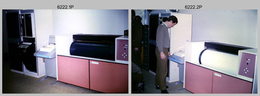
Photograph - AUTOMAP 2 Production - Army Survey Regiment, Fortuna, Bendigo, c1992
... Air Survey and Cartographic Squadrons, was most likely taken in circa 1992. The AUTOMAP 2 system was an upgrade to the AUTOMAP 1 system, comprising Intergraph graphic edit workstation terminals networked to VAX 750/785 main frame computers. Unlike AUTOMAP 1, operators could display digital topographic features on monitors for editing. Successful adaptation of this system meant RASvy was at the forefront of digital mapping/cartographic systems in Australia and overseas. The system comprised Input (Wild B8 Aviograph feature extraction) Raster Scanning (digitising from compilation sheets, Graphic Edit (cartographic completion) and Plot...Air Survey and Cartographic Squadrons, was most likely taken in circa 1992. The AUTOMAP 2 system was an upgrade to the AUTOMAP 1 system, comprising Intergraph graphic edit workstation terminals networked to VAX 750/785 main frame computers. Unlike AUTOMAP 1, operators could display digital topographic features on monitors for editing. Successful adaptation of this system meant RASvy was at the forefront of digital mapping/cartographic systems in Australia and overseas. The system comprised Input (Wild B8 Aviograph feature extraction) Raster Scanning (digitising from compilation sheets, Graphic Edit (cartographic completion) and Plot ...This collection of 16 photos of map production on the AUTOMAP 2 computer-based system in Air Survey and Cartographic Squadrons, was most likely taken in circa 1992. The AUTOMAP 2 system was an upgrade to the AUTOMAP 1 system, comprising Intergraph graphic edit workstation terminals networked to VAX 750/785 main frame computers. Unlike AUTOMAP 1, operators could display digital topographic features on monitors for editing. Successful adaptation of this system meant RASvy was at the forefront of digital mapping/cartographic systems in Australia and overseas. The system comprised Input (Wild B8 Aviograph feature extraction) Raster Scanning (digitising from compilation sheets, Graphic Edit (cartographic completion) and Plot Verification Sub Systems. The system was operational from 1984 to its ‘Newheart’ upgrade in 1993. Throughout its life, the system was progressively refined with productivity gains, achieved from award winning technical development in-house by talented and innovative Army Survey Regiment personnel. See Item 6223.23P for more photos of AUTOMAP 2 production. This is a set of 16 photograph of AUTOMAP 2 production at the Army Survey Regiment at Fortuna, Bendigo, c1992. The photographs are on 35mm negative film and scanned at 96 dpi. They are part of the Army Survey Regiment’s Collection. .1) to .3) - Photo, colour, c1992, AUTOMAP 2 Graphic Edit Workstation, SGT Rick van der Bom. .4) - Photo, colour, c1992, AUTOMAP 2 Benson 5342 verification plotter. .5) - Photo, colour, c1992, AUTOMAP 2 Intergraph verification plotter. .6) & .7) - Photo, colour, c1992, AUTOMAP 2 Graphic Edit Workstation, SGT Phil Smalley. .8) - Photo, colour, c1992, AUTOMAP 2 Mapsetter Scanner/Plotter Workstation, SPR Ken Labouchardiere. .9) - Photo, colour, c1992, AUTOMAP 2 Mapsetter 4900 Scanner/Plotter. .10) - Photo, colour, c1992, AUTOMAP 2 Graphic Edit Workstation, CPL Mick McConnell. .11) - Photo, colour, c1992, AUTOMAP 2 Graphic Edit Workstation, CPL Peter Smyth. .12) - Photo, colour, c1992, AUTOMAP 2 Graphic Edit Workstation, SPR Annette (Odgers) Wynn. SGT Sherri (Dally) Burke in background. .13) - Photo, colour, c1992, AUTOMAP 2 Graphic Edit Workstation, SPR Rachel (Stanford) Scott. .14) - Photo, colour, c1992, AUTOMAP 2 Graphic Edit Workstation, unidentified technician. .15) - Photo, colour, c1992, AUTOMAP 2 Graphic Edit Workstation, SPR Bob Bousfield. .16) - Photo, colour, c1992, AUTOMAP 2 Stereo Workstation, CPL Brian Johnson..1P to .16P – There are no annotationsroyal australian survey corps, rasvy, fortuna, army survey regiment, automap 2 -
 Bendigo Military Museum
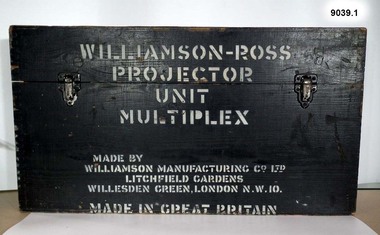
Instrument - Multiplex Unit Projector, Williamson Manufacturing Co, Circa 1950
... Multiplex plotting was a productive advancement replacing the ‘Arundel’ method of graphical plotting planimetric detail that was expensive and slow, especially in timbered mountainous terrain. Air...Multiplex plotting was a productive advancement replacing the ‘Arundel’ method of graphical plotting planimetric detail that was expensive and slow, especially in timbered mountainous terrain. Air ...Multiplex mechanical stereoplotting equipment was used at the Army Survey Regiment, Fortuna Bendigo. c1950s. Multiplex equipment was imported from the UK in 1951 and introduced in the following year, to accelerate map production output covering CMF training areas at 1:25,000 map scale. Multiplex plotting was a productive advancement replacing the ‘Arundel’ method of graphical plotting planimetric detail that was expensive and slow, especially in timbered mountainous terrain. Air photos were made into small diapositives and mounted on racks in the exact position relative to when the aerial photos were taken. The technicians operated the Multiplex in a darkened room, with one photo projected with a green filter and the other through a red filter to form a 3D view of the overlapping photos. The 3D model projected onto a platen, which was a small platform that was raised up and down. The technician viewed the 3D image with special glasses fitted with red and green lenses. In the centre of the platen was a small pinhole that served as a floating mark, with a vertical pencil located exactly below the pinhole. This tracing table was moved to follow the topographic feature or contour line and draw it on the paper underneath. The technician raising or lowering the platform’s floating mark to match the height of the 3D terrain. It also replaced the slotted template method of mechanical adjustment of strips of aerial photography, however was restricted to each strip rather than between strips in the block. Although the Multiplex was phased out of production in 1968, it was used in the training of photogrammetry and aero-triangulation at the School of Military Survey located at Bonegilla, Victoria until the early 1990s. The history of the Multiplex is covered in more detail with additional historic photographs, in pages 50 to 51 of Valerie Lovejoy’s book 'Mapmakers of Fortuna – A history of the Army Survey Regiment’ ISBN: 0-646-42120-4. This instrument is only one of the projectors of a set and is unfortunately missing its coloured filters and coloured glasses. Another instrument is in the collection as Item 9003.4A black wooden box containing a Multiplex Unit Projector (incomplete). The Multiplex has a Lamp Head, Barrel Housing, Body of the Projector and a Platen. .1 Protective wooden box .2 Multiplex Instrument .3 Multiplex Instrument Parts Diagram .4 A bank of Multiplex projectors in operation WILLIAMSON MANUFACTURING CO, PHOTOGRAPHIC ENGINEERS, SERIAL NUMBER 3187, TYPE MPC, LITCHFIELD GARDENS, LONDON AND READING.royal australian survey corps, rasvy, fortuna, army survey regiment, army svy regt -
 Bendigo Military Museum
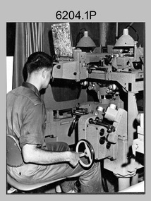
Photograph - Capturing Topographic Features with a Wild B8, AUTOMAP 1 Systems Operations – Army Survey Regiment, Fortuna, Bendigo, 1980
... This is a set of 24 photographs of Air Survey Squadron technicians capturing topographic Features with a Wild B8 stereo plotter and operating AUTOMAP 1 equipment at the Army Survey Regiment at Fortuna, Bendigo, 1980. 17 of these photographs were taken of SPR Nick Van Dalen and SPR Santina (Argetto) Straube capturing topographic features – plotting with a Wild B8 stereo plotter were most likely taken in 1980. ...This is a set of 24 photographs of Air Survey Squadron technicians capturing topographic features with a Wild B8 stereo plotter and operating AUTOMAP 1 equipment at the Army Survey Regiment at Fortuna, Bendigo, c1980. ...plotter. The history of the AUTOMAP 1 system is covered in more detail with additional historic photographs in pages 116-118 of Valerie Lovejoy’s book 'Mapmakers of Fortuna – A history of the Army Survey Regiment’ ISBN: 0-646-42120-4. See items 6122.20P, 6183.19P, 6184.20P, 6200.5P, and 6222.17P for additional photographs of the AUTOMAP 1 system. automap 1 Royal Australian Survey Corps RASvy Army Survey Regiment Army Svy Regt Fortuna ASR Photogrammetry .1P to .24P – no annotations. This is a set of 24 photographs of Air ...This is a set of 24 photographs of Air Survey Squadron technicians capturing topographic Features with a Wild B8 stereo plotter and operating AUTOMAP 1 equipment at the Army Survey Regiment at Fortuna, Bendigo, 1980. 17 of these photographs were taken of SPR Nick Van Dalen and SPR Santina (Argetto) Straube capturing topographic features – plotting with a Wild B8 stereo plotter were most likely taken in 1980. See item 6185.4P for black & white copies of photos of SPR Santina (Argetto) Straube operating the Wild B8 stereo plotter. Refer to item 6204.8P for detailed information and additional photographs of the Wild B8 stereo plotter. The history of the AUTOMAP 1 system is covered in more detail with additional historic photographs in pages 116-118 of Valerie Lovejoy’s book 'Mapmakers of Fortuna – A history of the Army Survey Regiment’ ISBN: 0-646-42120-4. See items 6122.20P, 6183.19P, 6184.20P, 6200.5P, and 6222.17P for additional photographs of the AUTOMAP 1 system.This is a set of 24 photographs of Air Survey Squadron technicians capturing topographic features with a Wild B8 stereo plotter and operating AUTOMAP 1 equipment at the Army Survey Regiment at Fortuna, Bendigo, c1980. The photographic proofs were printed on photographic paper and are part of the Army Survey Regiment’s Collection. The photographic proof prints were scanned at 600 dpi. .1) to .8) Photo, black & white, 1980. SPR Santina (Argetto) Straube operating a Wild B8 stereo plotter. .9) to .17) Photo, black & white, 1980. SPR Nick Van Dalen operating a Wild B8 stereo plotter. .18) to .24) Photo, black & white, 1980. CPL Gerry Gunn undertaking AUTOMAP 1 computer system duties..1P to .24P – no annotations.automap 1, royal australian survey corps, rasvy, army survey regiment, army svy regt, fortuna, asr, photogrammetry -
 Bendigo Military Museum
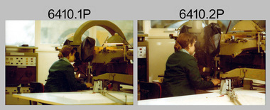
Photograph - AUTOMAP 1 Production – Army Survey Regiment, Fortuna, Bendigo, c1979
... Air Survey Squadron military and civilian personnel operating AUTOMAP 1 equipment at the Army Survey Regiment at Fortuna, Bendigo, c1979. The photographs were on 35mm negative film and were scanned at 96 dpi. They are part of the Army Survey Regiment’s Collection. .1) - Photo, colour, c1979, Gradicon edit table, SSGT John Bennett. .2) - Photo, colour, c1979, Gradicon edit table. .3) - Photo, colour, c1979, HP21MX computer General Purpose Sub-system. .4) - Photo, colour, c1979, HP21MX computer General Purpose Sub-system. L to R: CAPT Graham Baker, SPR Ian Belmont. .5) - Photo, colour, c1979, Gerber verification drum plotter...Air Survey Squadron military and civilian personnel operating AUTOMAP 1 equipment at the Army Survey Regiment at Fortuna, Bendigo, c1979. The photographs were on 35mm negative film and were scanned at 96 dpi. They are part of the Army Survey Regiment’s Collection. .1) - Photo, colour, c1979, Gradicon edit table, SSGT John Bennett. .2) - Photo, colour, c1979, Gradicon edit table. .3) - Photo, colour, c1979, HP21MX computer General Purpose Sub-system. .4) - Photo, colour, c1979, HP21MX computer General Purpose Sub-system. L to R: CAPT Graham Baker, SPR Ian Belmont. .5) - Photo, colour, c1979, Gerber verification drum plotter ...This collection of 19 photos was most likely taken in 1980. The AUTOMAP 1 computer assisted cartography and mapping system was introduced in 1975. The components of AUTOMAP 1 were the Input Sub-System of four Wild B8s stereoplotters and three Gradicon digitising tables, the Optical Line Following Sub-System – Gerber OLF, the Verification Sub-System – Gerber 1442 drum plotter, the General Purpose Sub-system – HP21MX computer and the Output Sub-System – Gerber 1232 flatbed plotter). The first map was published in 1978 (Strickland 3665-3, 1:50,000). AUTOMAP 1 was the first computer assisted cartography and mapping system utilised by the Survey Corps and was the first system used by Australian mapping organisations. The history of the AUTOMAP 1 system is covered in more detail with additional historic photographs, in pages 116-118 of Valerie Lovejoy’s book 'Mapmakers of Fortuna – A history of the Army Survey Regiment’ ISBN: 0-646-42120-4. See items 6122.20P, 6410.24P, 6184.20P, 6200.5P, and 6222.17P for additional photographs of the AUTOMAP 1 system.This is a set of 19 photographs of Air Survey Squadron military and civilian personnel operating AUTOMAP 1 equipment at the Army Survey Regiment at Fortuna, Bendigo, c1979. The photographs were on 35mm negative film and were scanned at 96 dpi. They are part of the Army Survey Regiment’s Collection. .1) - Photo, colour, c1979, Gradicon edit table, SSGT John Bennett. .2) - Photo, colour, c1979, Gradicon edit table. .3) - Photo, colour, c1979, HP21MX computer General Purpose Sub-system. .4) - Photo, colour, c1979, HP21MX computer General Purpose Sub-system. L to R: CAPT Graham Baker, SPR Ian Belmont. .5) - Photo, colour, c1979, Gerber verification drum plotter. 1130 System administration, unidentified. .6) - Photo, colour, c1979, Gerber Optical Line Follower (OLF). .7) - Photo, colour, c1979, Gerber OLF .8) - Photo, black & white, c1979, Programming and system administration, L to R: WO1 Don Taylor, Robert Cox, Tony Spurling, SSGT John Bennett, SGT Alan Toogood. .9) to .14) - Photo, black & white, c1979, .15) - Photo, black & white, c1979, Gerber OLF, unidentified. .16) - Photo, black & white, c1979, Gerber verification drum plotter, unidentified using Gradicon edit table. .17) to .18) - Photo, black & white, c1979, - Photo, black & white, c1979, Programming and system administration, SSGT John Bennett. .19)- Photo, black & white, c1979, - Photo, black & white, c1979, HP21MX computer General Purpose Sub-system..1P to .19P No personnel are identified.royal australian survey corps, rasvy, army survey regiment, army svy regt, fortuna, asr, automap 1 -
 Bendigo Military Museum
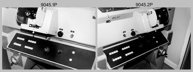
Photograph - Aerotriangulation Production – Army Survey Regiment, Fortuna, Bendigo, c1979
... Air Survey Squadron in 1963. Aerotriangulation production was expedited using computers for analytical photogrammetric processes. The technician accurately measured between pass, tie, and survey control points on aerial photographs. The OMI/Nistri AP/C-3 analytical plotter...Royal Australian Survey Corps RASvy Army Survey Regiment Army Svy Regt Fortuna ASR aerotrig air survey .5P is annotated ‘OMI-Nistri AP/C Analytical Plotter’ and ’Topo 36’. .12P is annotated ‘Zeiss Jena Stecometer Stereocomparator’ and ’Topo 35’. ...This collection of 19 photos was most likely taken in 1979 in Air Survey Squadron. The PDP 11/70 minicomputer shown in photos .2P to .3P was the operating system introduced in 1977 as the mainframe system for the control of the APC4, aerial triangulation block adjustments, SORA OP Analytical Orthophoto control, APR Analytical Terrain Profile Recorder computation, graphics, and general computing. The Zeiss (Jena) Stecometer analytic stereocomparator for air photography shown in photos .5P to .9P was introduced at Air Survey Squadron in 1963. Aerotriangulation production was expedited using computers for analytical photogrammetric processes. The technician accurately measured between pass, tie, and survey control points on aerial photographs. The OMI/Nistri AP/C-3 analytical plotter shown in photos .10P and .11P was introduced in 1972–1973. Photo .11P shows a coordinatorgraph attached to the AP/C-3. The Zeiss D2 Planimat Stereoplotter shown in photo .12P was used for analytical orthophoto control. Wild PUG4 point transfer devices shown in photos .17P to .19P were introduced in c1968 superseding the PUG2 devices. PUG4 devices were used by technicians to stereoscopically view the photography containing the survey control points and the mapping aerial photography. The Control points were transferred from the control photography to the mapping diapositives of aerial photography by drilling their locations into the photographic emulsion.See item 9045.17P for more photos of aerotriangulation equipment and their operation in map production.This is a set of 19 photographs of Air Survey Squadron personnel operating aerotriangulation equipment at the Army Survey Regiment at Fortuna, Bendigo, c1979. Black and white photos are on photographic paper and were scanned at 300 dpi. They are part of the Army Survey Regiment’s Collection. .1) - Photo, black & white, c1979, Aerotriangulation tasks, unidentified technicians. .2) to .3) - Photo, black & white, c1979, PDP-11 minicomputers tasks, unidentified technician. .4) - Photo, black & white, c1979, Aerotriangulation tasks, unidentified technician. .5) - Photo, colour, c1979, Zeiss (Jena) Stecometer, unidentified technician. .6) to.9) - Photo, black & white, c1979, Zeiss (Jena) Stecometer, unidentified technician. .10) - Photo, black & white, c1984, OMI/Nistri APC/3-1 analytical stereoplotter, SPR Kristin (Isaac) Skidmore. .11) - Photo, colour, c1979, OMI/Nistri APC/3-1 analytical stereoplotter, unidentified technician. .12) - Photo, colour, c1979, Zeiss D2 Planimat Stereoplotter, unidentified technician. .13) - Photo, black & white, c1979, Aerotriangulation tasks, unidentified technician. .14) - Photo, black & white, c1979, Aerotriangulation tasks, unidentified technician. .15) - Photo, black & white, c1979, Aerotriangulation tasks, CPL Ken Talbot-Smith .16) - Photo, black & white, c1979, Aerotriangulation tasks, SPR David Jobe. .17) - Photo, black & white, c1979, Wild PUG4 point transfer device, WO2 Brian Mead. .18) - Photo, black & white, c1979, Wild PUG4 point transfer device, CPL Andy Wilson. .19) - Photo, black & white, c1979, Wild PUG4 point transfer device, unidentified technician..5P is annotated ‘OMI-Nistri AP/C Analytical Plotter’ and ’Topo 36’. .12P is annotated ‘Zeiss Jena Stecometer Stereocomparator’ and ’Topo 35’. There are no annotations on the other photos.royal australian survey corps, rasvy, army survey regiment, army svy regt, fortuna, asr, aerotrig, air survey -
 Bendigo Military Museum
Photograph - Multiplex mechanical stereoplotting equipment, Army Survey Regiment, Fortuna Bendigo, c1950s
... Multiplex plotting was a productive advancement replacing the ‘Arundel’ method of graphical plotting planimetric detail that was expensive and slow, especially in timbered mountainous terrain. Air...Multiplex plotting was a productive advancement replacing the ‘Arundel’ method of graphical plotting planimetric detail that was expensive and slow, especially in timbered mountainous terrain. Air ...This is a set of five photographs of Multiplex mechanical stereoplotting equipment at the Army Survey Regiment, Fortuna Bendigo. c1950s. Multiplex equipment was imported from the UK in 1951 and introduced in the following year, to accelerate map production output covering CMF training areas at 1:25,000 map scale. Multiplex plotting was a productive advancement replacing the ‘Arundel’ method of graphical plotting planimetric detail that was expensive and slow, especially in timbered mountainous terrain. Air photos were made into small diapositives and mounted on racks in the exact position relative to when the aerial photos were taken. The technicians operated the Multiplex in a darkened room, with one photo projected with a green filter and the other through a red filter to form a 3D view of the overlapping photos. The 3D model projected onto a platen, which was a small platform that was raised up and down. The technician viewed the 3D image with special glasses fitted with red and green lenses. In the centre of the platen was a small pinhole that served as a floating mark, with a vertical pencil located exactly below the pinhole. This tracing table was moved to follow the topographic feature or contour line and draw it on the paper underneath. The technician raising or lowering the platform’s floating mark to match the height of the 3D terrain. It also replaced the slotted template method of mechanical adjustment of strips of aerial photography, however was restricted to each strip rather than between strips in the block. Although the Multiplex was phased out of production in 1968, it was used in the training of photogrammetry and aero-triangulation at the School of Military Survey located at Bonegilla, Victoria until the early 1990s. The history of the Multiplex is covered in more detail with additional historic photographs, in pages 50 to 51 of Valerie Lovejoy’s book 'Mapmakers of Fortuna – A history of the Army Survey Regiment’ ISBN: 0-646-42120-4.This is a set of five photographs of Multiplex mechanical stereoplotting equipment at the Army Survey Regiment, Fortuna, Bendigo. c1950s. The photographs were printed on photographic paper and are part of the Army Survey Regiment’s Collection. The photographs were scanned at 300 dpi. .1) - Photo, black & white, c1950s, unidentified personnel operating Multiplex equipment. .2) - Photo, black & white, c1950s, Multiplex equipment. .3) - Photo, black & white, c1950s, Multiplex components identified. .4) - Photo, black & white, c1950s, Multiplex optical components. .5) - Photo, black & white, c1950s. Unidentified technician laying down individual Multiplex plots..1P to .2P, .4P – No annotations. .3P annotations identifying Multiplex components on front of photo. .5P annotated on front ‘Lay down of individual Multiplex plots at 1/14000 to framework of master grid to form Composite Compilation Sheet – Material Duralex.’royal australian survey corps, rasvy, army survey regiment, army svy regt, fortuna, asr, photogrammetry -
 Bendigo Military Museum
Photograph - AUTOMAP 1 Production – Army Survey Regiment, Fortuna, Bendigo, c1980
... Air Survey Squadron military personnel operating AUTOMAP 1 equipment at the Army Survey Regiment at Fortuna, Bendigo, c1980. Black and white photos are on photographic paper and were scanned at 300 dpi. They are part of the Army Survey Regiment’s Collection. .1) - Photo, black & white, c1980, SGT Cliff Webb operating AUTOMAP 1 terminal. .2) - Photo, black & white, c1980, HP21MX computer General Purpose Sub-system. .3) - Photo, black & white, c1980, Gerber verification drum plotter. .4) and .5) - Photo, black & white, c1980, unidentified personnel operating AUTOMAP 1 terminal. ...Air Survey Squadron military personnel operating AUTOMAP 1 equipment at the Army Survey Regiment at Fortuna, Bendigo, c1980. Black and white photos are on photographic paper and were scanned at 300 dpi. They are part of the Army Survey Regiment’s Collection. .1) - Photo, black & white, c1980, SGT Cliff Webb operating AUTOMAP 1 terminal. .2) - Photo, black & white, c1980, HP21MX computer General Purpose Sub-system. .3) - Photo, black & white, c1980, Gerber verification drum plotter. .4) and .5) - Photo, black & white, c1980, unidentified personnel operating AUTOMAP 1 terminal. ...This collection of five photos was most likely taken in c1980. The AUTOMAP 1 computer assisted cartography and mapping system was introduced in 1975. The components of AUTOMAP 1 were the Input Sub-System of four Wild B8s stereoplotters and three Gradicon digitising tables, the Optical Line Following Sub-System – Gerber OLF, the Verification Sub-System – Gerber 1442 drum plotter, the General Purpose Sub-system – HP21MX computer and the Output Sub-System – Gerber 1232 flatbed plotter). The first map was published in 1978 (Strickland 3665-3, 1:50,000). AUTOMAP 1 was the first computer assisted cartography and mapping system utilised by the Survey Corps and was the first system used by Australian mapping organisations. The history of the AUTOMAP 1 system is covered in more detail with additional historic photographs, in pages 116-118 of Valerie Lovejoy’s book 'Mapmakers of Fortuna – A history of the Army Survey Regiment’ ISBN: 0-646-42120-4. See items 6410.24P, 6122.20P, 6183.19P, 6184.20P and 6222.17P for more photos of the AUTOMAP 1 computer system.This is a set of five photographs of Air Survey Squadron military personnel operating AUTOMAP 1 equipment at the Army Survey Regiment at Fortuna, Bendigo, c1980. Black and white photos are on photographic paper and were scanned at 300 dpi. They are part of the Army Survey Regiment’s Collection. .1) - Photo, black & white, c1980, SGT Cliff Webb operating AUTOMAP 1 terminal. .2) - Photo, black & white, c1980, HP21MX computer General Purpose Sub-system. .3) - Photo, black & white, c1980, Gerber verification drum plotter. .4) and .5) - Photo, black & white, c1980, unidentified personnel operating AUTOMAP 1 terminal. .1P to .5P - No personnel are identified.royal australian survey corps, rasvy, army survey regiment, army svy regt, fortuna, asr, automap 1 -
 Bendigo Military Museum
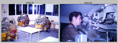
Photograph - Photogrammetric Equipment – Army Survey Regiment, Fortuna, Bendigo, c1960s to c1980s
... This is a set of eight photographs of technicians operating photogrammetric equipment in Air Survey Squadron, Army Survey Regiment, Fortuna, Bendigo. c1960s to c1980s. The Wild A9 Stereocomparator and Wild B9 stereo plotter were introduced in 1962. ...Air Survey Squadron, Army Survey Regiment, Fortuna, Bendigo. c1960s to c1980s. Black and white and colour photos are on photographic paper and scanned at 300 dpi. .1) - Photo, black & white, c1965. Unidentified technician operating a Wild A9 Stereocomparator. .2) - Photo, black & white, c1965. Unidentified technician operating a Wild B9 stereo plotter...Bendigo Military Museum 37 - 39 Pall Mall Bendigo goldfields This is a set of eight photographs of technicians operating photogrammetric equipment in Air Survey Squadron, Army Survey Regiment, Fortuna, Bendigo. c1960s to c1980s. The Wild A9 Stereocomparator and Wild B9 stereo plotter were introduced in 1962. ...This is a set of eight photographs of technicians operating photogrammetric equipment in Air Survey Squadron, Army Survey Regiment, Fortuna, Bendigo. c1960s to c1980s. The Wild A9 Stereocomparator and Wild B9 stereo plotter were introduced in 1962. The Wild B8 stereo plotter was introduced in 1966. Technicians used the Wild A9 Stereocomparator to accurately measure between pass, tie, and survey control points on aerial photographs. The Wild B9 and B8s were used for plotting topographic detail and contours. These analogue machines were manually controlled by adjusting the control knobs for the orientation of the 3D image. The B9s used a four and a half square, and the B8s used a nine-inch square photo image on a film or glass diapositive which allowed highly accurate extraction of map features. At first, plotting with B8 and B9 stereo plotters was undertaken at the aerial photography scale of 1:80,000 in pencil onto a controlled plotting sheet. Sheets were then inked up and reduced photographically to the 1: 100,000 publication scale for scribe impression production. In the early days topographic detail and contours were plotted with a pencil or ink pen mounted at the far end of the pantograph arm. The plotting procedure was upgraded to direct plotting in ink with photographic reduction to publication scale. In 1975 four B8s were upgraded with tri-axis locaters as part of the Input Sub-system to enable digital extraction to AUTOMAP 1’s topographic database. When AUTOMAP 2 was introduced in 1982 these B8s were upgraded, and additional machines added to expand the Army Survey Regiment’s digital capture capability. This is a set of eight photographs of technicians operating photogrammetric equipment in Air Survey Squadron, Army Survey Regiment, Fortuna, Bendigo. c1960s to c1980s. Black and white and colour photos are on photographic paper and scanned at 300 dpi. .1) - Photo, black & white, c1965. Unidentified technician operating a Wild A9 Stereocomparator. .2) - Photo, black & white, c1965. Unidentified technician operating a Wild B9 stereo plotter. .3) - Photo, black & white, c1967. L to R: Unidentified technician, SPR Ken Jeffery operating a Wild B9 stereo plotter. .4) - Photo, colour, c1974. Unidentified technician, operating a Wild B8 stereo plotter. .5) - Photo, black & white, c1974. Unidentified technician operating a Wild B8 stereo plotter. .6) to .7) - Photo, black & white, c1979. Unidentified technicians operating a Wild B8 stereo plotter. .8) - Photo, black & white, c1985. Unidentified technician in AUTOMAP 2 operating a Wild B8 stereo plotter..1P, .2P, .4P, .5P, .7P – no annotations. .3P – annotated ‘Standing - , Seated SPR Ken Jefferies (sic). .6P – annotated with date ‘1979’ .8P – annotated ‘AUTOMAP 2’royal australian survey corps, rasvy, army survey regiment, army svy regt, fortuna, asr, air survey, photogrammetry -
 Bendigo Military Museum
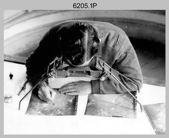
Photograph - Stereoscopic Equipment – Army Survey Regiment, Fortuna, Bendigo
... plotters introduced in the 1960s. Royal Australian Survey Corps Army Svy Regt RASvy Army Survey Regiment Fortuna ASR air survey Photogrammetry Photo .4P is annotated on back - ‘Bill Shapcott (CPL)’ This is a set of six photographs of stereoscopic equipment and personnel at the Army Survey Regiment, Fortuna, Bendigo, c1950s to c1960s. ...This is a set of six photographs of stereoscopic equipment and personnel at the Army Survey Regiment, Fortuna, Bendigo, c1950s to c1960s. The stereoscopes shown in photos .1P and .2P were used to stereoscopically view and interpret features in overlapping aerial photographs. The stereoscopic plotters shown in photos .3P and .4P were used to stereoscopically plot topographic detail from overlapping aerial photographs using a pantograph arm with pencil onto a controlled plotting sheet. The Ryker Model PL-3 Wernstedt-Mahan type stereoscopic plotter shown in photos .5P and .6P was used for precision contouring, planimetry and profiling. It was a comparatively simple stereoscopic mapping instrument designed to use ordinary contact prints of aerial photographs. It provides for plotting on a constant scale and approximate tilt correction but does not provide refinements such as correction for lens distortion. The plotter in Photo .6P does not have its pantograph arm attached. These plotters pre-date the Wild B9 and B8 stereo plotters introduced in the 1960s.This is a set of six photographs of stereoscopic equipment and personnel at the Army Survey Regiment, Fortuna, Bendigo, c1950s to c1960s. Black and white photos are on photographic paper and were scanned at 300 dpi. .1) - Photo, black & white, c1950s to c1960s, Universal Stereoscope, unidentified technician. .2) - Photo, black & white, c1950s to c1960s, Old Delft Scanning Stereoscopes, unidentified technicians. .3) - Photo, black & white, c1950s to c1960s, Unidentified stereoscopic plotters and technicians. .4) - Photo, black & white, c1950s to c1960s, Unidentified stereoscopic plotter, CPL Bill Shapcott. .5) and .6) - Photo, black & white, c1950s to c1960s, Ryker Model PL-3 stereoscopic plotter.Photo .4P is annotated on back - ‘Bill Shapcott (CPL)’royal australian survey corps, army svy regt, rasvy, army survey regiment, fortuna, asr, air survey, photogrammetry -
 Bendigo Military Museum
Photograph - AUTOMAP 1 Production – Army Survey Regiment, Fortuna, Bendigo, c1978-1980
... Air Survey Squadron military and civilian personnel operating AUTOMAP 1 equipment at the Army Survey Regiment at Fortuna, Bendigo, c1978-1980. The photographs were on 35mm colour slides and were scanned at 96 dpi. They are part of the Army Survey Regiment’s Collection. .1) - Photo, colour, c1978-1980, Gerber 1442 verification drum plotter...Air Survey Squadron military and civilian personnel operating AUTOMAP 1 equipment at the Army Survey Regiment at Fortuna, Bendigo, c1978-1980. The photographs were on 35mm colour slides and were scanned at 96 dpi. They are part of the Army Survey Regiment’s Collection. .1) - Photo, colour, c1978-1980, Gerber 1442 verification drum plotter ...This collection of 17 photos was most likely taken in c1978-1980. The AUTOMAP 1 computer assisted cartography and mapping system was introduced in 1975. The components of AUTOMAP 1 were the Input Sub-System of four Wild B8s stereoplotters and three Gradicon digitising tables, the Optical Line Following Sub-System – Gerber OLF, the Verification Sub-System – Gerber 1442 drum plotter, the General Purpose Sub-system – HP21MX computer and the Output Sub-System – Gerber 1232 flatbed plotter). The first map was published in 1978 (Strickland 3665-3, 1:50,000). AUTOMAP 1 was the first computer assisted cartography and mapping system utilised by the Survey Corps and was the first system used by Australian mapping organisations. The history of the AUTOMAP 1 system is covered in more detail with additional historic photographs, in pages 116-118 of Valerie Lovejoy’s book 'Mapmakers of Fortuna – A history of the Army Survey Regiment’ ISBN: 0-646-42120-4. See items 6122.20P, 6410.24P, 6183.19P, 6184.20P, and 6200.5P for additional photographs of the AUTOMAP 1 system.This is a set of 17 photographs of Air Survey Squadron military and civilian personnel operating AUTOMAP 1 equipment at the Army Survey Regiment at Fortuna, Bendigo, c1978-1980. The photographs were on 35mm colour slides and were scanned at 96 dpi. They are part of the Army Survey Regiment’s Collection. .1) - Photo, colour, c1978-1980, Gerber 1442 verification drum plotter. .2) - Photo, colour, c1978-1980, Gerber 1442 verification drum plotter, SPR Garry Ames. In background - Hewlett Packard (HP) 2100A Minicomputer Input Subsystem controlling Wild B8 Aviograph stereo plotters. .3) - Photo, colour, c1978-1980, Gerber 1442 verification drum plotter. .4) - Photo, colour, c1978-1980, digitising topographic features with a Wild B8 Aviograph stereo plotter, CPL Adrian Rynberk. .5) to .6) - Photo, colour, c1978-1980, Wild PEB8 stereo profiler. .7) - Photo, colour, c1980, HP 9640A Programming System. .8) - Photo, colour, c1980, HP 9640A Programming System, L to R: unidentified, SGT Alan Toogood. .9) - Photo, colour, c1978-1980, Gerber Optical Line Follow (OLF), CAPT Rob Bridge. .10) - Photo, colour, c1978-1980, Gerber OLF. .11.) to .12) - Photo, colour, c1978-1980, Gerber OLF, SPR Gerry Gunn. .13) - Photo, colour, c1978-1980, Gerber OLF. .14) - Photo, colour, c1979, Gradicon edit table. .15) to .16) - Photo, colour, c1981, Gradicon edit table, SPR Chris Gordon. .17) - Photo, colour, c1981, Gradicon edit table, L to R: SPR Chris Brown, unidentified..1P to .17P - Some of the equipment is annotated on the frame of the 35mm slides.royal australian survey corps, rasvy, army survey regiment, army svy regt, fortuna, asr, automap 1 -
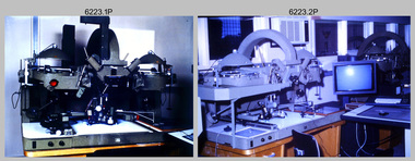 Bendigo Military Museum
Photograph - AUTOMAP 2 Production - Army Survey Regiment, Fortuna, Bendigo, c1986
... Air Survey and Cartographic Squadrons, was most likely taken in 1986. The AUTOMAP 2 system was an upgrade to the AUTOMAP 1 system, comprising Intergraph graphic edit workstation terminals networked to VAX 750/785 main frame computers. Unlike AUTOMAP 1, operators could display digital topographic features on monitors for editing. Successful adaptation of this system meant RASvy was at the forefront of digital mapping/cartographic systems in Australia and overseas. The system comprised Input (Wild B8 Aviograph feature extraction) Raster Scanning (digitising from compilation sheets, Graphic Edit (cartographic completion) and Plot...Air Survey and Cartographic Squadrons, was most likely taken in 1986. The AUTOMAP 2 system was an upgrade to the AUTOMAP 1 system, comprising Intergraph graphic edit workstation terminals networked to VAX 750/785 main frame computers. Unlike AUTOMAP 1, operators could display digital topographic features on monitors for editing. Successful adaptation of this system meant RASvy was at the forefront of digital mapping/cartographic systems in Australia and overseas. The system comprised Input (Wild B8 Aviograph feature extraction) Raster Scanning (digitising from compilation sheets, Graphic Edit (cartographic completion) and Plot ...This collection of 23 photos of map production on the AUTOMAP 2 computer-based system in Air Survey and Cartographic Squadrons, was most likely taken in 1986. The AUTOMAP 2 system was an upgrade to the AUTOMAP 1 system, comprising Intergraph graphic edit workstation terminals networked to VAX 750/785 main frame computers. Unlike AUTOMAP 1, operators could display digital topographic features on monitors for editing. Successful adaptation of this system meant RASvy was at the forefront of digital mapping/cartographic systems in Australia and overseas. The system comprised Input (Wild B8 Aviograph feature extraction) Raster Scanning (digitising from compilation sheets, Graphic Edit (cartographic completion) and Plot Verification Sub Systems. The system was operational from 1984 to its ‘Newheart’ upgrade in 1993. Throughout its life, the system was progressively refined with productivity gains, achieved from award winning technical development in-house by talented and innovative Army Survey Regiment personnel.This is a set of 23 photograph of AUTOMAP 2 production at the Army Survey Regiment at Fortuna, Bendigo, c1986. The photographs were on 35mm colour slides and were scanned at 96 dpi. Photos .5P and .6P are also printed on photographic and scanned at 300 dpi. They are part of the Army Survey Regiment’s Collection. .1) - Photo, colour, c1986, AUTOMAP 2 Production - Army Survey Regiment, Fortuna, Bendigo. c1986. .2) - Photo, colour, c1986, AUTOMAP 2 Wild B8 Aviograph stereoplotter. .3) - Photo, colour, c1986, AUTOMAP 2 Wild B8 Aviograph stereoplotter feature extraction, unidentified technician. .4) - Photo, colour, c1986, Wild B8 Aviograph stereoplotter feature extraction, LCPL Raelene (Munting) Brodie. .5) - Photo, colour, c1986, AUTOMAP 2 computer tape maintenance, SPR Steve Linane. .6) - Photo, colour, c1986, AUTOMAP 2 Graphic Edit Workstation, SPR Steve Linane. .7) to .8) - Photo, colour, c1986, AUTOMAP 2 Graphic Edit Workstation, unidentified technician. .9 to .10) - Photo, colour, c1986, AUTOMAP 2 Graphic Edit Workstation. .11) - Photo, colour, c1986, AUTOMAP 2 Graphic Edit Workstation feature coding and command menu. .12) - Photo, colour, c1986, AUTOMAP 2 high resolution computer monitor. .13) to .16) - Photo, colour, c1986, AUTOMAP 2 production output comparison to AUTOMAP 1. .17) to .18) - Photo, colour, c1986, AUTOMAP 2 computer system components. .19) - Photo, colour, c1986, AUTOMAP 2 Intergraph 7596 verification plotter. .20) - Photo, colour, c1986, AUTOMAP 2 Benson verification plotter, SPR Steve Coulson. .21) - Photo, colour, c1986, AUTOMAP 2 drainage, contour, roads and cultural digital data verification plot. .22) - Photo, colour, c1986, AUTOMAP 2 drainage, contour, roads and cultural digital data on computer monitor. .23) - Photo, colour, c1986, AUTOMAP 2 3D digital terrain model on computer monitor. .1P to .23P - Some of the equipment is annotated on the frame of the 35mm slides. .5P & .6P prints annotated incorrectly ‘Steve Lenane’. Correct spelling is - ‘Steve Linane’ royal australian survey corps, rasvy, army survey regiment, army svy regt, fortuna, asr, automap 2 -
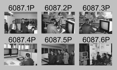 Bendigo Military Museum
Photograph - Technical Tour of the Army Survey Regiment, Fortuna, Bendigo, c1984
... It’s evident in these photos the visitors were taken on a tour through the production areas of Air Survey Squadron, with Wild B8 photogrammetic plotting workstations featured in the first three photos and demonstrations of the AUTOMAP 2 production system in the following photos. ...It’s evident in these photos the visitors were taken on a tour through the production areas of Air Survey Squadron, with Wild B8 photogrammetic plotting workstations featured in the first three photos and demonstrations of the AUTOMAP 2 production system in the following photos. ...This collection of 10 photos was most likely taken in 1984. It’s evident in these photos the visitors were taken on a tour through the production areas of Air Survey Squadron, with Wild B8 photogrammetic plotting workstations featured in the first three photos and demonstrations of the AUTOMAP 2 production system in the following photos. The AUTOMAP 2 system was an upgrade to the AUTOMAP 1 system comprising Intergraph graphic edit workstation terminals networked to VAX 750/785 main frame computers. Unlike AUTOMAP 1, operators could display digital topographic features on monitors for editing. Successful adaptation of this system meant RASvy was at the forefront of digital mapping/cartographic systems in Australia and overseas. The system comprised Input (B8 feature extraction) Raster Scanning (digitising from compilation sheets, Graphic Edit (cartographic completion) and Plot Verification Sub Systems. CAPT Rob John was the project officer responsible for the acceptance trials and implementation of AUTOMAP 2. The system was operational from 1984 to its ‘Newheart’ upgrade in 1993. Throughout its life, the system was progressively refined with productivity gains, achieved from award winning technical development in-house by talented and innovative Army Survey Regiment personnel.This is a set of 10 photograph of a technical tour of the Army Survey Regiment at Fortuna, Bendigo, c1985. The photographs were printed on 35mm photographic proofing paper and are part of the Army Survey Regiment’s Collection. The photographs were scanned at 600 dpi. .1) - Photo, black & white, c1984, unidentified visitors, CAPT Rob John, MAJ Jim Mitchell, unidentified. .2) - Photo, black & white, c1984, unidentified visitor. .3) - Photo, black & white, c1984, unidentified visitor. .4) - Photo, black & white, c1984, unidentified SGT .5) - Photo, black & white, c1984, L to R: LTCOL Jorge Gruszka, unidentified visitors. .6) - Photo, black & white, c1984, L to R: SGT George Timmins, unidentified visitors. .7) - Photo, black & white, c1984, MAJ John Charland – US Exchange Officer. .8) - Photo, black & white, c1984, L to R: unidentified visitors and personnel, MAJ John Charland – US Exchange Officer. .9) - Photo, black & white, c1984, unidentified visitors and personnel, MAJ John Charland – US Exchange Officer in background. .10) - Photo, black & white, c1984, L to R: MAJ Bob Roche, CAPT Mick Byrne in Officers Mess..1P to .10P No personnel are identifiedroyal australian survey corps, rasvy, army survey regiment, army svy regt, fortuna, asr, air survey, automap -
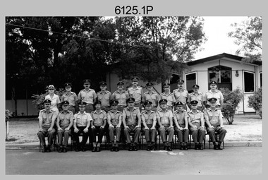 Bendigo Military Museum
Photograph - Army Survey Regiment’s Officers, Warrant Officers and Sergeants and Squadrons, at Fortuna, Bendigo, 1982
... Air Survey Squadron was responsible for aerotriangulation, photogrammetric feature extraction and the AUTOMAP 1 system. Typical tasks were flight planning the acquisition of aerial photography, pugging, mensuration and block adjustments, photogrammetric extraction of topographic features from aerial photography, digital feature editing, map compilation, operating the scanner/plotter, operating the AUTOMAP 1 system and computer programming by civilians. ...Air Survey Squadron was responsible for aerotriangulation, photogrammetric feature extraction and the AUTOMAP 1 system. Typical tasks were flight planning the acquisition of aerial photography, pugging, mensuration and block adjustments, photogrammetric extraction of topographic features from aerial photography, digital feature editing, map compilation, operating the scanner/plotter, operating the AUTOMAP 1 system and computer programming by civilians. ...This is a set of six staff photographs of the Army Survey Regiment’s Officers, Warrant Officers and Sergeants, and each of its four Squadrons at Fortuna, Bendigo in December 1982. Note - Air Survey Squadron’s photo was probably taken in July 1982 as they appear in winter dress. Air Survey Squadron was responsible for aerotriangulation, photogrammetric feature extraction and the AUTOMAP 1 system. Typical tasks were flight planning the acquisition of aerial photography, pugging, mensuration and block adjustments, photogrammetric extraction of topographic features from aerial photography, digital feature editing, map compilation, operating the scanner/plotter, operating the AUTOMAP 1 system and computer programming by civilians. Cartographic Squadron was responsible for the production of the following military products: Joint Operation Graphics, small-scale RAAF Air Charts, large-scale topographic line maps and orthophotomaps. Cartographic technician tasks were scribing, compiling, retouching, masking, type setting, type stickup, terrain embossing, correcting and proving quality control. Headquarters Squadron was responsible for the planning and coordination of map production and contracts. It also performed administrative and support functions such as personnel administration, pay, finance, transportation, records, map Library, kitchens, messes and facility maintenance. It was staffed by Army personnel from RASvy, RACT, AACC, RAAOC and RAEME corps. Other supporting staff at this time included the RAAF Liaison Officer, RAN Liaison Officer and several civilians employed in administration, the Q-Store and grounds maintenance. A component of the Army Svy Regt’s cartographic map production was carried out by the Detachment, a sub-unit located at Bonegilla next to the School of Military Survey. Lithographic Squadron was responsible for the reproduction of map materials and printing of military map products. The main tasks undertaken by photographic technicians were photographic enlargements, reductions and duplication of map reproduction material and processing of aerial photography. Printing technician tasks included platemaking, offset printing, map stock despatching and proofing.This is a set of six staff photographs of the Army Survey Regiment’s Officers, Warrant Officers and Sergeants, and its four Squadrons, at Fortuna, Bendigo, 1982. The black and white photographs were printed on photographic paper and are part of the Army Survey Regiment’s Collection. The photograph was scanned at 300 dpi. No personnel are identified. No personnel are identified. .1P – Annotated on front “OFFICERS MESS DEC ’82” .2P – Annotated on back “SGTS MESS DEC ’82” .4P– Annotated on front “CARTO SQN DEC ’82” .5P– Annotated on front “HQ SQN DEC ’82”royal australian survey corps, rasvy, army survey regiment, army svy regt, fortuna, asr, air survey, carto, litho -
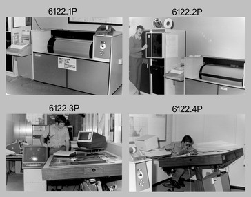 Bendigo Military Museum
photograph - AUTOMAP 1 Production – Army Survey Regiment, Fortuna, Bendigo, c1980
... Air Survey Squadron military and civilian personnel operating AUTOMAP 1 equipment at the Army Survey Regiment at Fortuna, Bendigo, c1980. The photographs were on 35mm negative film and were scanned at 96 dpi. They are part of the Army Survey Regiment’s Collection. Photos .19P and .20P are printed on photographic and scanned at 300 dpi. .1) - Photo, black & white, c1980, Gerber plotter...Air Survey Squadron military and civilian personnel operating AUTOMAP 1 equipment at the Army Survey Regiment at Fortuna, Bendigo, c1980. The photographs were on 35mm negative film and were scanned at 96 dpi. They are part of the Army Survey Regiment’s Collection. Photos .19P and .20P are printed on photographic and scanned at 300 dpi. .1) - Photo, black & white, c1980, Gerber plotter ...This collection of 20 photos was most likely taken in 1980. The AUTOMAP 1 computer assisted cartography and mapping system was introduced in 1975. The components of AUTOMAP 1 were the Input Sub-System of four Wild B8s stereoplotters and three Gradicon digitising tables, the Optical Line Following Sub-System – Gerber OLF, the Verification Sub-System – Gerber 1442 drum plotter, the General Purpose Sub-system – HP21MX computer and the Output Sub-System – Gerber 1232 flatbed plotter). The first map was published in 1978 (Strickland 3665-3, 1:50,000). AUTOMAP 1 was the first computer assisted cartography and mapping system utilised by the Survey Corps and was the first system used by Australian mapping organisations. The history of the AUTOMAP 1 system is covered in more detail with additional historic photographs, in pages 116-118 of Valerie Lovejoy’s book 'Mapmakers of Fortuna – A history of the Army Survey Regiment’ ISBN: 0-646-42120-4. See items 6410.24P, 6183.19P, 6184.20P, 6200.5P, and 6222.17P for additional photographs of the AUTOMAP 1 system.This is a set of 20 photographs of Air Survey Squadron military and civilian personnel operating AUTOMAP 1 equipment at the Army Survey Regiment at Fortuna, Bendigo, c1980. The photographs were on 35mm negative film and were scanned at 96 dpi. They are part of the Army Survey Regiment’s Collection. Photos .19P and .20P are printed on photographic and scanned at 300 dpi. .1) - Photo, black & white, c1980, Gerber plotter. .2) - Photo, black & white, c1980, Gerber plotter, LT Rob John .3) - Photo, black & white, c1980, Gradicon edit table, SPR Jamie McRae .4) - Photo, black & white, c1980, Gradicon edit table, SPR Steve Linane .5) - Photo, black & white, c1980, 1130 System administration, unidentified. .6) - Photo, black & white, c1980, Wild B8 stereo plotter, SPR Van Dalen? .7) - Photo, black & white, c1980, Wild B8 stereo plotter, SPR Van Dalen? .8) - Photo, black & white, c1980, Gerber Optical Line Follower (OLF). .9) - Photo, black & white, c1980, Gerber OLF. .10) - Photo, black & white, c1980, Gerber OLF. .11) - Photo, black & white, c1980, Gerber OLF. .12) - Photo, black & white, c1980, Gerber OLF. .13) - Photo, black & white, c1980, Data management, CPL Greg Gilbert. .14) - Photo, black & white, c1980, Data management, CPL Greg Gilbert. .15) - Photo, black & white, c1980, 1130 Operating System administration, SGT Denis Marshall. .16) - Photo, black & white, c1980, Programming System, L to R: unidentified, SGT Alan Toogood. .17) - Photo, black & white, c1980, Programming System, L to R: Robert Cox, WO1 Bob Mason, John Dean. .18) - Photo, black & white, c1980, Programming System, L to R: Robert Cox, WO1 Bob Mason, John Dean. .19) - Photo, black & white, c1980, Gradicon edit table, CPL Chris Carter. .20) - Photo, black & white, c1980, Gerber plotter, LT Rob John..1P to .18P - No personnel are identified .19P - ‘CPL Chris Carter’ annotated on backroyal australian survey corps, rasvy, army survey regiment, army svy regt, fortuna, asr, air survey, automap -
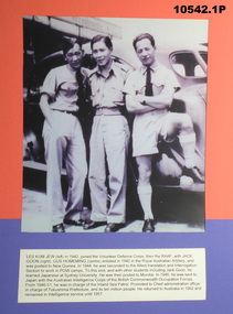 Bendigo Military Museum
Photograph - AUSTRALIAN CHINESE SERVICEMEN/WOMEN, WW2, Bendigo & District RSL Club, Unknown
... plotter with the WAAAF, and her brother MAX (bottom right) went with the British Commonwealth Occupation Forces to Japan after the War. 3. PETER MOO (top right) served with the Australian Army in the Northern Territory, his brother FRANK MOO (top centre) served with the Australian Imperial Force in Rabaul and Bougainville, Frank's children CLARENCE MOO (top right) served with the Royal Australian Engineers and then transferred to the Royal Australian Air Force HARRY MOO (bottom left) served with the Royal Australian Air Force's 31 Beaufighter Squadron in Darwin and Morotai, MAVIS MOO (bottom centre) served with the Australian Army Medical Women's Service and ARTHUR MOO (bottom right) served with the Australian Army and later the Royal Australian Air Force. ...plotter with the WAAAF, and her brother MAX (bottom right) went with the British Commonwealth Occupation Forces to Japan after the War. 3. PETER MOO (top right) served with the Australian Army in the Northern Territory, his brother FRANK MOO (top centre) served with the Australian Imperial Force in Rabaul and Bougainville, Frank's children CLARENCE MOO (top right) served with the Royal Australian Engineers and then transferred to the Royal Australian Air Force HARRY MOO (bottom left) served with the Royal Australian Air Force's 31 Beaufighter Squadron in Darwin and Morotai, MAVIS MOO (bottom centre) served with the Australian Army Medical Women's Service and ARTHUR MOO (bottom right) served with the Australian Army and later the Royal Australian Air Force. 1.2.3. ...Australian Chinese Servicemen from WW2 photographs - Exhibition held at the Bendigo & District RSL, post 2010.1.2.3. Photographs on photographic paper, enlarged black and white portraits. Mount - red and blue colour cardboard, double mount with top area containing the photograph, lower area printed information. 1. Three servicemen in informal group. 2. Two servicewomen, one serviceman and a civilian - group portrait. 3. Five servicemen and one service woman in uniform - collection of small portraits.Printed information - black ink print. 1. LES KUM JEW (left)- in 1942, joined the Volunteer Defence Corps, then the RAAF, with JACK GOON (right). GUS HOMEMING (centre) enlisted in 1942 in the Royal Australian Artillery, and was posted to New Guinea. In 1944, he was seconded to the Allied translation and Interrogation Section to work in POW camps. To this end, and with other students including Jack Goon, he learned Japanese at Sydney University. He was then posted to Morotai. In 1946, he was sent to Japan with the Australian Intelligence Corps of the British Commonwealth Occupation Forces. From 1946-51, he was in charge of the Inland Sea Patrol. Promoted to Chief Administration Officer in charge of Tokushima Prefecture and its ten million people. He returned to Australia in 1952 and remained in Intelligence service until 1957. 2. EUNICE LEONG (top left) worked from 1940 as a wireless operator for the Army in Melbourne, Sydney and Alice Springs, and as a signals instructor at Bonegilla. Her sister, VALDA (top right) worked as a radar plotter with the WAAAF, and her brother MAX (bottom right) went with the British Commonwealth Occupation Forces to Japan after the War. 3. PETER MOO (top right) served with the Australian Army in the Northern Territory, his brother FRANK MOO (top centre) served with the Australian Imperial Force in Rabaul and Bougainville, Frank's children CLARENCE MOO (top right) served with the Royal Australian Engineers and then transferred to the Royal Australian Air Force HARRY MOO (bottom left) served with the Royal Australian Air Force's 31 Beaufighter Squadron in Darwin and Morotai, MAVIS MOO (bottom centre) served with the Australian Army Medical Women's Service and ARTHUR MOO (bottom right) served with the Australian Army and later the Royal Australian Air Force. photographs, chinese/australians, ww2 -
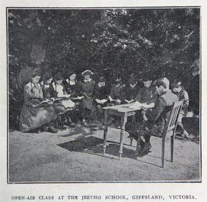 Federation University Historical Collection
Book, Victoria Education Gazette and Teachers' Aid, 1911-1919, 1910-1919
... Black hard covered book with red spine, holding Victorian Education Gazettes for one calendar year. .1) 1910 .2) 1912 .3) 1911 .4) 1914 .5) 1918 Images: Open Air Classroom Black Rock; Open Air Classroom, Jeetho, Gippsland; Open Air Nurses bedroom, Mildura; Gym at Canterbury School ; Babies and Nurses at Melbourne Foundling Hospital; Camp at Portland; Alexander Peacock Opens a Melbourne School; Unveiling Major Mitchell Memorial at Mt Arapiles; Agricultural Plot; School Interior; Swimming Drill; Graham Dux Prize Board; Bathing Place; Classroom with blackboard and pictures; Major Mitchell's Map; Melbourne, Derbyshire; Market Place Melbourne; The Blackwood; World War One Send-off at The Athenaeum; Scarsdale Old Boy's logo; Sloyd articles for the Field Hospital; World War One; Gifts for Transport to the Wharf; soldiers; ANZAC Day; ANZAC Day Medalion .5) 1915: Education Department's War Relief Fund, William Park obituary, Closer Settlement Act 1912, Agriculture, needlework, Swimming and Life Saving, explorers, Gregory Blaxland, Matthew Flinders, Composition, Geography, potatoes, onions, gardens, Needlework for Infants, Iona and Staffa, Trained Primary Teacher's Course, Electricity, Electrical Technology, hygiene, Arbour Day, Horticulture, Wattle Day, Bird Day, Technical Schools, Landing at Gaba Tepe, Evils of Alcohol, Old Boys of Scarsdale, Belgium, Teachers' College Images: The British at War, The Sonnet, History and Patriotism, Male Swimming Teachers Summer School at Geelong, Women Swimming Teachers at Port Fairy, Buln Buln State School, Burwood East State School, needlework plans, methods of Rescue and Resucitation. plan of the journey of Gregory Blaxland, Macquarie House, teachers killed (William Ross Hoggart, Stanley Robert Close, William Roy Hodgson, Campbell McDiarmid Peter, William Henry Dawkins, William Hugh Hamilton, Frederick McRae Neal, Vernon Brookes, Frank J. ...Bailey Black hard covered book with red spine, holding Victorian Education Gazettes for one calendar year. .1) 1910 .2) 1912 .3) 1911 .4) 1914 .5) 1918 Images: Open Air Classroom Black Rock; Open Air Classroom, Jeetho, Gippsland; Open Air Nurses bedroom, Mildura; Gym at Canterbury School ; Babies and Nurses at Melbourne Foundling Hospital; Camp at Portland; Alexander Peacock Opens a Melbourne School; Unveiling Major Mitchell Memorial at Mt Arapiles; Agricultural Plot; School Interior; Swimming Drill; Graham Dux Prize Board; Bathing Place; Classroom with blackboard and pictures; Major Mitchell's Map; Melbourne, Derbyshire; Market Place Melbourne; The Blackwood; World War One Send-off at The Athenaeum; Scarsdale Old Boy's logo; Sloyd articles for the Field Hospital; World War One; Gifts for Transport to the Wharf; soldiers; ANZAC Day; ANZAC Day Medalion .5) 1915: Education Department's War Relief Fund, William Park obituary, Closer Settlement Act 1912, Agriculture, needlework, Swimming and Life Saving, explorers, Gregory Blaxland, Matthew Flinders, Composition, Geography, potatoes, onions, gardens, Needlework for Infants, Iona and Staffa, Trained Primary Teacher's Course, Electricity, Electrical Technology, hygiene, Arbour Day, Horticulture, Wattle Day, Bird Day, Technical Schools, Landing at Gaba Tepe, Evils of Alcohol, Old Boys of Scarsdale, Belgium, Teachers' College Images: The British at War, The Sonnet, History and Patriotism, Male Swimming Teachers Summer School at Geelong, Women Swimming Teachers at Port Fairy, Buln Buln State School, Burwood East State School, needlework plans, methods of Rescue and Resucitation. plan of the journey of Gregory Blaxland, Macquarie House, teachers killed (William Ross Hoggart, Stanley Robert Close, William Roy Hodgson, Campbell McDiarmid Peter, William Henry Dawkins, William Hugh Hamilton, Frederick McRae Neal, Vernon Brookes, Frank J. ...Black hard covered book with red spine, holding Victorian Education Gazettes for one calendar year. .1) 1910 .2) 1912 .3) 1911 .4) 1914 .5) 1918 Images: Open Air Classroom Black Rock; Open Air Classroom, Jeetho, Gippsland; Open Air Nurses bedroom, Mildura; Gym at Canterbury School ; Babies and Nurses at Melbourne Foundling Hospital; Camp at Portland; Alexander Peacock Opens a Melbourne School; Unveiling Major Mitchell Memorial at Mt Arapiles; Agricultural Plot; School Interior; Swimming Drill; Graham Dux Prize Board; Bathing Place; Classroom with blackboard and pictures; Major Mitchell's Map; Melbourne, Derbyshire; Market Place Melbourne; The Blackwood; World War One Send-off at The Athenaeum; Scarsdale Old Boy's logo; Sloyd articles for the Field Hospital; World War One; Gifts for Transport to the Wharf; soldiers; ANZAC Day; ANZAC Day Medalion .5) 1915: Education Department's War Relief Fund, William Park obituary, Closer Settlement Act 1912, Agriculture, needlework, Swimming and Life Saving, explorers, Gregory Blaxland, Matthew Flinders, Composition, Geography, potatoes, onions, gardens, Needlework for Infants, Iona and Staffa, Trained Primary Teacher's Course, Electricity, Electrical Technology, hygiene, Arbour Day, Horticulture, Wattle Day, Bird Day, Technical Schools, Landing at Gaba Tepe, Evils of Alcohol, Old Boys of Scarsdale, Belgium, Teachers' College Images: The British at War, The Sonnet, History and Patriotism, Male Swimming Teachers Summer School at Geelong, Women Swimming Teachers at Port Fairy, Buln Buln State School, Burwood East State School, needlework plans, methods of Rescue and Resucitation. plan of the journey of Gregory Blaxland, Macquarie House, teachers killed (William Ross Hoggart, Stanley Robert Close, William Roy Hodgson, Campbell McDiarmid Peter, William Henry Dawkins, William Hugh Hamilton, Frederick McRae Neal, Vernon Brookes, Frank J. Olle, Alfred J. Collins, Ernest R. Fairlie, William J. McLaren, A.E. Smith, Thomas Patton, Francis W. Kemp, Frederick G. Hall, Rupert O. Hepburn, Woolston J. Govan), Frederick Harold Tubb VC, Botanic Gardens Red Gum, Shelter Pavillions, Head of Wheat, Australian Commonwealth Flag, Iona Cathedral, Drawing exercises, ANZAC Madallion, School Rolls of Honor .6) 1916 - Nature Study, war relief, school gardening, horticulture, singing class, geography of the war, School Rolls of Honour, Ponsonby Carew-Smyth, Astronomy, ANZAC Day, Empire Day, Arbor Day, "Some Suul of Goodness in Things Evil" by Frank Tate, War Relief Gardeners' League, ANZAC Day medallion, Solar System, Abolition of German Schools in Victoria, ANZAC Avenues, avenues of honour, Geography of the War: The West, War relief and handwork, Victorian State Schools Horticultural Society, Patrick Maloney obituary, formalin lamps, Victoria League of Victoria, Wonwondah East Roll of Honor Images - Teachers killed (John Clarke, A.C.H. Jackson, Alexander Robertson, Noel Gambetta, Ralp E. Leyland, Laurance J. Woodruff, Walter E. Cass, Percy D. Moncur, Thomas M. Carmichael, Edward G. Brain, Reginald N.F. Woods, George E. James, William Colvin, David Dobson, Stanley L. Robinson, Charles Allen, G.E. James, H.F. Curnow, Franl L. Cousins, James R. Thompson, Henry H. Campbell, George E. Read, Ernest D. Morshead, Wilfred S. Merlin, Henry R. Wright, George B. Webb, Noel Nicholas, David H. Thomas, Charles A. Levens, Thomas R. Fenner, John M. Daniell, P.J. Larkin, Ralph Smith, Philip Ormsby), school rolls of honour, Swimming Instructors at Queenscliff, The Southern Sky, Map of the North Sea and its Littorals, Easter School of Horticulture at Oakleigh, Map of the Eastern Front, Map of Mesopotamia, Map of the War Area in the Egyptian Campaign, leeches for the Melbourne Hospital .7) 1917 - Swimming and Life-Saving, Childre's FLower Day, Education Department's War Relief Fund, State War Council, Horticulture, Bird Day, Swimming, Growing Chicory at Cowes Images - Teachers killed during World War One (G.M. Nicholas, William C.W. Spencer, J.W.C. Profitt, Ivon C. Bromilow, John Colwell, Robert W. Campbell, Arthur P. Bourchier, Francid G. Houston, Claude N. Harrison, Edgar Williams, Leslie A. Stevens, Charles E. W. Chester, Stanley R. Green, Walter Baker, Arthur G. Scott, Harry L. Swinburne, Horace W. Brown, Arnold Bretherton, Edward W. Jenkins Aubrey Liddelow, Ewen A. Cameron, Edmund R. Lyall, John H. Martin, Harry Bell, Frank L. Nicholls, Melville R. Hughes, Edwin W. Hauser, Walter S. Filmer, Walter G. Barlow, Henry A. Donaldson, Edward H. Jones, Walter W. Raw, Alfred W. Dean, Wiliam Lea, Frederick G. Drury, J.T. Richards, Norman G. Pelton, Lance-Corporal Doran, Kenneth F. McKenzie, William F. Robertson, Wiliam Jarrott, Norman Graham, George G. Paul, Victor Green, Arthur William Rennie, Alfred J. Glendinning, Robert B. Liston, Eward P. Toll, George Jones, Errol E. Rodda, Christian P. Christensen, Charles F. Sydes, H.G. Clements, Norman C. Fricker, J.M. Romeo. Eric N. Lear, Thomas J. Bartley, Norval Birrell, Frederick H. Tubb. J.T. Hamilton Aram, Arthur Wilcock, William M. Conroy, Alex. H. Miller, Patrick J. Cunningham, Charles S. Mitchell, John R. Maddern, James Roadknight, Harry Arundel, Jack C. McKellar, duncan M. McKellar, George S. Manfield, Edgar C. Holmes, George A. Young, Raymond A. Gardiner, William B. Bell, William Opie, George R. Scott, Richard V.B. Vine, Herbery S. Marshall, Hugh St Omer Dentry, George B. Fullerton, Harry Oulton, Iva F. Morieson), School Honor Books, Drawing, Presentation of 30,000 pounds to the British Red Cross at Melbourne Town Hall .8) 1918 .9) 1919 - Photographs of World War One soldiers from the Education Department, Margaret Montgomery Memorial, 1918 Act relating to State School Teachers, State Scolarships, Victorian State Schools' Horticultural Society, Pneumonic Influenza, Spanish Flu, epedemic, swimming and life savinfJunior cadet training, vacancies in Fiji, School Committees, Arbor Day, Arbour Day, Henry Harding of Yinnar, Planting Trees and Shrubs, Juvenile Crime, The use of 'Get', Soldier-Teachers from Overseas in Congress London, Australia's Effort in the War, Military, Working Bees, Tree Planting, fence building, Welcoming Home a Returned Soldier, Avenue of Honour planting, Discipline, Unveiling an Honor Board, School gymnasium, school tennis court, E. E. Crogger grave at Aldershot, The School Honor Book. War Relief Fund, Commonwealth War Record, Caulfield Military Hosptial, ANZAC Day Pilgrimage, Jimmie Panikin, Donald Fraser, Arthur Mee, Card Sun Dial, Balboa Day in Honolulu, William Hamilton, Alfred Jackson, The Backward Child, Flies, Language Teaching and Learning, Spelling, The Education of the Adolescent, victorian education gazette, education gazette and teachers' aid, sloyd, william a. cavanagh, james i froebel, school, education, world war one, memorials, alfred williams, exploration and settlement, cadets, australian naval college, bernard o;dowd, birds, swimming, drawingempire league, eucalypts, paper in history, forestry, arbor day, identification of trees, forestrey museums, fiji, gravel hill school band, horticulture, hygiene, gould league of bird lovers, life saving, la perouse, bandin, j. holland, w. hamilton, charles sturt, principles of archimedes, james holland, william hamilton, scarsdale old boys' reunion, foundling home melbourne, montessori education, open air schools, james hughes, marie corelli, flinders sydney harbour, major mitchell's map, tooth brushing, r.h.s. bailey -
 Bendigo Military Museum
Photograph - CGS LTGEN Coates and RSM-A WO1 Wendt Visit to the Army Survey Regiment, Fortuna, Bendigo, 1990
... Air Survey Squadron tour. CGS LTGEN John Coates AC MBE views stereo aerial photography on a Wild B8 stereo plotter. .16) - Photo, colour, 1990. ...Air Survey Squadron tour. CGS LTGEN John Coates AC MBE views stereo aerial photography on a Wild B8 stereo plotter. .16) - Photo, colour, 1990. ...This set of 43 photographs was taken in August 1990 during the Australian Army Chief of the General Staff (CGS) and Regimental Sergeant-Major of the Australian Army (RSM-A) visit to the Army Survey Regiment, Fortuna, Bendigo. Lieutenant General Henry John Coates AC MBE was a senior officer in the Australian Army who served as Chief of the General Staff from 1990 to 1992. RSM-A WO1 Kevin ‘Lofty’ Wendt OAM BEM was the 2nd RSM to be appointed to the position of RSM-A, the most senior Warrant Officer position in the Australian Army. His appointment was from 1987 to 1990. The name of the CGS’s aide de camp officer is unknown. The CGS and RSM-A visit to the Army Survey Regiment is covered on page 145 of Valerie Lovejoy’s book 'Mapmakers of Fortuna – A history of the Army Survey Regiment’ ISBN: 0-646-42120-4. See Item 6154.6P for additional photos taken during the visit.This is a set of 43 photographs taken on the occasion of the Chief of the General Staff - Lieutenant General Henry John Coates AC MBE visit to the Army Survey Regiment, Bendigo in August 1990. Colour photographs are on 35mm negative film and scanned at 2400 dpi. They are part of the Army Survey Regiment’s Collection. .1) - Photo, colour, 1990. Arrival of the CGS at Fortuna Villa. L to R: unidentified RACT driver, CO LTCOL Rene van den Tol., unidentified aide de camp officer. .2) - Photo, colour, 1990. The CGS’s staff car, noting the 3 stars on red plate below the number plate. .3) - Photo, colour, 1990. Partners accompanying the tour delegation arrive at Fortuna Villa. Mrs Ruth van den Tol is 2nd from right, remainder unidentified. .4) - Photo, colour, 1990. The visitors gather at Fortuna Villa’s front steps. L to R: unidentified (x2), RSM-A WO1 Kevin ‘Lofty’ Wendt OAM BEM, unidentified (x2), Mrs Ruth van den Tol, unidentified. In background L to R: CGS LTGEN John Coates AC MBE, CO LTCOL Rene van den Tol. .5) - Photo, colour, 1990. The visitors gather at Fortuna Villa’s front steps. L to R: RSM WO1 Neville Stone, unidentified, RSM-A WO1 Kevin ‘Lofty’ Wendt OAM BEM, Mrs Ruth van den Tol, unidentified (x2). .6) - Photo, colour, 1990. The visitors gather at Fortuna Villa’s front steps. L to R: unidentified, RSM-A WO1 Kevin ‘Lofty’ Wendt OAM BEM, Mrs Ruth van den Tol, unidentified (x4). In background – RSM WO1 Neville Stone. .7) - Photo, colour, 1990. The visitors gather at Fortuna Villa’s front steps. L to R: RSM WO1 Neville Stone. unidentified, RSM-A WO1 Kevin ‘Lofty’ Wendt OAM BEM, unidentified (x4). Mrs Ruth van den Tol. .8) - Photo, colour, 1990. At Fortuna Villa’s front steps. L to R: RSM WO1 Neville Stone. RSM-A WO1 Kevin ‘Lofty’ Wendt OAM BEM. .9) - Photo, colour, 1990. CO LTCOL Rene van den Tol at left invites CGS LTGEN John Coates AC MBE to sign the Visitors’ Book outside the Messes. .10) - Photo, colour, 1990. Production Control Office. L to R: CO LTCOL Rene van den Tol, CAPT Roger Hancock, CGS LTGEN John Coates AC MBE, WO1 Colin Cuskelly. .11) - Photo, colour, 1990. Fortuna Villa Historic Tour. Unidentified visitors in the entrance foyer guided by CPL Le-Anne (Smallshaw) Shirley at far right. Mrs Ruth van den Tol faces the camera. .12) - Photo, colour, 1990. Descending the external stairway L to R: 2IC Maj Duncan Burns, CGS LTGEN John Coates AC MBE, unidentified aide de camp officer, CO LTCOL Rene van den Tol. .13) - Photo, colour, 1990. Air Survey Squadron brief L to R: LT Simon Buckpitt, OC MAJ Peter Clark, CO LTCOL Rene van den Tol, CGS LTGEN John Coates AC MBE, unidentified aide de camp officer. .14) - Photo, colour, 1990. Air Survey Squadron tour. CGS LTGEN John Coates AC MBE watches as CPL Darren Wilkinson operates a B8 stereo plotter on the AUTOMAP 2 system. .15) - Photo, colour, 1990. Air Survey Squadron tour. CGS LTGEN John Coates AC MBE views stereo aerial photography on a Wild B8 stereo plotter. .16) - Photo, colour, 1990. Air Survey Squadron tour. L to R: SSGT Andy Boath guides the CGS LTGEN John Coates AC MBE’s operation of a Wild B8 stereo plotter fitted with dual optics on the AUTOMAP 2 system. .17) - Photo, colour, 1990. Air Survey Squadron tour. L to R: SSGT Andy Boath explains a AUTOMAP 2 system feature coding menu to the CGS LTGEN John Coates AC MBE next to a Wild B8 stereo plotter. .18) - Photo, colour, 1990. Air Survey Squadron tour. L to R: SPR Paula (Golding) Brinsmead explains off-table map editing procedure to RSM-A WO1 Kevin ‘Lofty’ Wendt OAM BEM. RSM WO1 Neville Stone stands on the background. .19) - Photo, colour, 1990. Air Survey Squadron tour. L to R: SPR Paula (Golding) Brinsmead explains off-table map editing procedure to RSM-A WO1 Kevin ‘Lofty’ Wendt OAM BEM. .20) - Photo, colour, 1990. Cartographic Squadron brief. L to R: CGS LTGEN John Coates AC MBE, CAPT Dave McLachlan, CO LTCOL Rene van den Tol. .21) - Photo, colour, 1990. Cartographic Squadron tour. SPR Ian Baldwin demonstrates AUTOMAP 2 system cartographic editing on a Graphic Editing Workstation. Standing L to R: CAPT Dave McLachlan, CGS LTGEN John Coates AC MBE, CO LTCOL Rene van den Tol. .22) - Photo, colour, 1990. Cartographic Squadron tour. AUTOMAP 2 system cartographic editing demonstrated on a Graphic Editing Workstation. Standing L to R: LT Steve Hledik, unidentified aide de camp officer CAPT Dave McLachlan, 2IC MAJ Duncan Burns, CGS LTGEN John Coates AC MBE. .23) - Photo, colour, 1990. Lithographic Squadron brief. L to R: OC MAJ Bob Coote, CGS LTGEN John Coates AC MBE. .24) - Photo, colour, 1990. Lithographic Squadron tour. Aerial photograph film processing brief. L to R: CGS LTGEN John Coates AC MBE. OC MAJ Bob Coote, LT Marty Lyons in background. .25) - Photo, colour, 1990. Lithographic Squadron tour. Map separation film processing brief. L to R: OC MAJ Bob Coote, CGS LTGEN John Coates AC MBE. .26) - Photo, colour, 1990. Lithographic Squadron tour. Production of an orthophotomap proof brief. L to R: CGS LTGEN John Coates AC MBE. OC MAJ Bob Coote .27) - Photo, colour, 1990. Lithographic Squadron tour. KLIMCH large format camera brief. L to R: CGS LTGEN John Coates AC MBE, WO1 Bill Jones. .28) - Photo, colour, 1990. Lithographic Squadron tour. KLIMCH large format camera brief. L to R: CO LTCOL Rene van den Tol, CGS LTGEN John Coates AC MBE. .29) - Photo, colour, 1990. Lithographic Squadron tour. KLIMCH large format camera brief. L to R: CGS LTGEN John Coates AC MBE, WO1 Bill Jones, SPR Gavin Craggs. .30) - Photo, colour, 1990. Lithographic Squadron tour. Film enlargement/reduction process brief. L to R: WO1 Bill Jones, CGS LTGEN John Coates AC MBE, OC MAJ Bob Coote. Unidentified aide de camp officer, 2IC MAJ Duncan Burns in background. .31) - Photo, colour, 1990. Lithographic Squadron tour. Colour topographic map proof production brief. L to R: OC MAJ Bob Coote, CGS LTGEN John Coates AC MBE, WO1 Bill Jones. .32) - Photo, colour, 1990. Lithographic Squadron tour. L to R: CGS LTGEN John Coates AC MBE, OC MAJ Bob Coote. .33) - Photo, colour, 1990. Lithographic Squadron entrance. L to R: RSM WO1 Neville Stone, RSM-A WO1 Kevin ‘Lofty’ Wendt OAM BEM, unidentified, WO2 Rob Bogimul. .34) - Photo, colour, 1990. Lithographic Squadron entrance. L to R: RSM-A WO1 Kevin ‘Lofty’ Wendt OAM BEM. .35) - Photo, colour, 1990. Lithographic Squadron entrance. L to R: RSM-A WO1 Kevin ‘Lofty’ Wendt OAM BEM, WO2 Rob Bogimul. .36) - Photo, colour, 1990. Lithographic Squadron entrance. L to R: RSM WO1 Neville Stone, RSM-A WO1 Kevin ‘Lofty’ Wendt OAM BEM, WO2 Rob Bogimul. .37) - Photo, colour, 1990. Lithographic Squadron tour. Print Room introductions. L to R: in background – WO2 Rob Bogimul, Unidentified aide de camp officer. In foreground - CGS LTGEN John Coates AC MBE, OC MAJ Bob Coote, WO2 Jeff Willey, 2IC MAJ Duncan Burns. .38) & .39) - Photo, colour, 1990. Lithographic Squadron. RSM-A WO1 Kevin ‘Lofty’ Wendt OAM BEM addresses Army Survey Regiment personnel in the Print Room. .40) - Photo, colour, 1990. Lithographic Squadron. Presentation of the Army Survey Regiment unit plaque. L to R: RSM-A WO1 Kevin ‘Lofty’ Wendt OAM BEM, RSM WO1 Neville Stone. .41) to .43) - Photo, colour, 1990. Lithographic Squadron. RSM-A WO1 Kevin ‘Lofty’ Wendt OAM BEM addresses Army Survey Regiment personnel in the Print Room..1P to .43P – Not annotated. Stored with ‘CMDR 3MD Visit Mar 90’ film negative sleeve sets.royal australian survey corps, rasvy, army survey regiment, army svy regt, fortuna -
 Marysville & District Historical Society
Book, Arthur Catherall, Vanished Whaler, 1953
... air pilot and observer employed as scouts by a Norwegian whaling expedition. Sent out to find the Oslo, a whale-chaser which seems to be out of wireless touch with the parent ship, they find her all right, but deserted! Deserted in that desert of snow and ice the Antartic Circle. This is only the beginning of a great adventure, of plots ...Jim and his friend Nugget are air pilot and observer employed as scouts by a Norwegian whaling expedition. Sent out to find the Oslo, a whale-chaser which seems to be out of wireless touch with the parent ship, they find her all right, but deserted! Deserted in that desert of snow and ice the Antartic Circle. This is only the beginning of a great adventure, of plots and counter plots centered around a Spanish treasure-ship locked for three centuries in the ice.No dust cover. Book is bound in blue with the title and author in black on the front cover and the spine.fictionJim and his friend Nugget are air pilot and observer employed as scouts by a Norwegian whaling expedition. Sent out to find the Oslo, a whale-chaser which seems to be out of wireless touch with the parent ship, they find her all right, but deserted! Deserted in that desert of snow and ice the Antartic Circle. This is only the beginning of a great adventure, of plots and counter plots centered around a Spanish treasure-ship locked for three centuries in the ice.whaling, whaling ship, adventure, arthur catherall, fiction